Yamal-Land-Cover Land-Use Change (NASA LCLUC) Workshop A.V.Khomutov, M.O.Leibman
|
|
|
- Augusta Waters
- 5 years ago
- Views:
Transcription


1 Yamal-Land-Cover Land-Use Change (NASA LCLUC) Workshop A.V.Khomutov, M.O.Leibman Earth Cryosphere Institute SB RAS, Tyumen-Moscow

2
3 Landscape and Vegetation zoning of Yamal Peninsula E.S.Melnikov s scheme of landscape zoning of the North of West Siberia and Melnikov et al s map of landscape complexes of Western Siberia oil&gas province (Landscapes 1983, Pemafrost 2002) Yamal province of marine tundra plains (mt) is divided into 3 subprovinces: -northern tundra marine plains (mt 1 ) -middle tundra marine plains (mt 2 ) -southern tundra marine plains (mt 3 ). Each subprovince is subdivided into several landscape regions. The scheme of zonal structure of vegetation (Il ina et al. 1985, Nature , Monitoring 1997) Yamal Peninsula is subdivided into: -arctic tundra subzone (I)=bioclimate subzone C -typical tundra of subarctic tundra subzone (II 1 ) =bioclimate subzone D -shrub tundra of subarctic tundra subzone (II 2 ) =bioclimate subzone E.


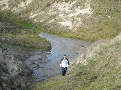
4 Research location Vaskiny Dachi: Dachi: overview map Panzananayakha river
, upper than 35 m above sea level (Terrace IV) 3-III fluvial-marine plain, upper than 25 m above sea level (Terrace III) 4-Terrace II 5-Terrace I 6-flood plain of Mordyyakha river")
5 Research location Vaskiny Dachi: landscape pattern Map of geomorphological levels 1-V marine plain ( Salekhardskaya ), upper than 45 m above sea level (Terrace V) Camp site 2-IV coastal-marine plain ( Kazancevskaya ), upper than 35 m above sea level (Terrace IV) 3-III fluvial-marine plain, upper than 25 m above sea level (Terrace III) 4-Terrace II 5-Terrace I 6-flood plain of Mordyyakha river Legend Lakes Landscape units

6 Camp site Research location Vaskiny Dachi: landscape pattern Landscape-geomorphological map Legend for landscape units was composed. Based on table with data of geomorphological levels, slope steepness, active-layer deposits and vegetation. Examples of landscape units: 1 drained partly bare flat&convex surfaces of marine plain with unclosed grassshrub-moss-lichen tundra on sandy&loamy-sand deposits with gruss and gravel Flat surfaces (steepnees <1 ) drained boggy peaty Gentle slopes (steepness 1-3 ) Cryogenic landslides 1989 old Gentle slopes (steepness 3-7 ) drained boggy Steep slopes (steepness >7 ) Stream valleys boggy peaty Lakes Landscape units 14 boggy vegetated low lake terraces of costal-marine plain with herb-shrub-lichen-moss tussocky bogs on peaty loamysand&loam deposits with peat 33 irregular-drained vegetated gentle slopes of fluvial-marine plain with herbmoss-shrub tundra on loamyclayey deposits.


 7c 7b Hill top with shrublichen")


 7a vegetation 7b Landslide")
7 Research location Vaskiny Dachi: : landscape pattern of CALM grid 8 6 Hummocky slope with shrub-herb-moss tundra (Betula nana is dominant in shrubs) 6 Landslide body (partly rumpled) with rare herbmoss-willow complexes 8 Landslide share surface with pioneer vegetation Hill top with shrubherb-moss-lichen tundra Huge wind-blown sands 7a 9 Gully Gentle slope with herbmoss-shrub tundra (Salix is dominant) 7c 7b Hill top with shrublichen tundra with spot-medallions Gully branch With wet thick shrub-sedge complex Hummockytussocky concave slope with herb-shrub moss tundra Hummocky slope with herb-moss-shrub tundra (Betula nana is dominant) 7a Landslide share surface with pioneer vegetation 7b Landslide share surface with rare herb-shrub complexe 9 Gully

8 Disturbances classification in out of immediate gas field development zone Disturbances Natural Natural-technogenic Technogenic Areal Linear Cryogenic landsliding Reindeer overgrazing Quarries Vehicle tracks Deflation Parkings Thermoerosion


9 Cryogenic landsliding Landslide share surface Undisturbed slope Landslide body «Frontal zone» Landslide share surface Landslide body «Frontal zone»


10 Thermoerosion Catchment, river head Valley Valley train


11 Cryogenic landsliding and thermoerosion paragenesis Flat bare surface Fast cutting in the share surface Flattened gully slopes on landslide share surface 1989 Bare surface with vegetated landslide blocks, deep narrow gully in the center 2007 Overgrown surface with pioneer herb complexes, deep wide gully on most of the surface,


12 Convex undisturbed surfaces Deflation Spot-medalionhymmocky suface overgrown by lichens with initial blowout spots Wind-blown sands 2006 Repeated windblow, secondary wind-blown area forming 2005


13 Natural-technogenic disturbances: sequence of events Vegetated surface Trampled-down surface (organic substrate without vegetation) Overgrowing Vegetated surface Overgrazed and trampleddown wind-blown area Overgrown wind-blown area Trampling down Secondary wind-blown area Vegetated gully slope Overgrazing and trampling-down Cryogenic landslide activation


14 Technogenic disturbances Linear Vegetation diversity changing 2007 Areal Vegetation diversity changing (parkings) Vegetation cover destruction (quarries)


15 Research location Laborovaya: : overview


16 Research location Laborovaya: : landscape pattern overview Mountain part Plain part


17 Research location Laborovaya: : overview of disturbances Natural Deflation Curum forming Solifluction River mechanics Technogenic as a result of Obskaya-Bovanenkovo railway construction Quarries


18 Field data 2007 within the framework of NASA-LCLUC project Research location Laborovaya LAB-1 site LAB-2 site cm cm T0 9 T1 0 T1 1 T1 2 T1 3 T1 4 T1 5 T1 6 T1 7 T1 8 AL depth range: cm cm


19 Research location Vaskiny Dachi VD-1 site cm AL depth range: cm VD-3 site AL depth range: cm cm T29 T30 T19 T20 T21 T22 T23 VD-2 site cm AL depth range: cm T31 T32 T24 T25 T26 T27 T28 T33
 VD-2")

20 Research location Vaskiny Dachi VD CALM grid 2007 (for comparison) VD-2 site cm cm T24 T25 T26 T27 T28 AL depth range: cm AL depth range: cm


21 Research location Vaskiny Dachi Comparison of active layer depths on VD CALM grid in 1995 and cm cm AL depth range: cm AL depth range: cm
")
22 Potential Research locations Kharasavey Bely (White) Island


23 Research locations Kharasavey Herb-moss tundra in depressions and shrub-lichen-moss tundra on watershed tops and slopes. Meadow ecosystems in low sea coast

24 Bely (White) Island Popov s s Polar Station Low marine plain with marine and lake-marine sandy and loamy deposits Limited number of landscape units Arctic lichen tundra and sites of moss tundra
25 Conclusions: There is correlation between main landscape controls and active-layer dynamics, cryogenic processes and degree of landscape change under natural and technogenic disturbances. Vegetation as one of the main landscape components is subject to severe disturbance and responds to environmental changes faster than other landscape components. Research locations on study are representative of southern, middle and northern subzones of Yamal Peninsula when studying landscape pattern

26
Global Level GIS. Geocryological Map of the USSR, 1: , 1991
 Geocryological Map of the USSR, 1: 2 500 000, 1991 (Editor E.D.Ershov, Moscow State University, Faculty of Geology, Geocryological department) Global Level GIS Compiled for almost 20 years; Based on modeling
ACTIVE LAYER MONITORING IN NORTHERN WEST SIBERIA
 ACTIVE LAYER MONITORING IN NORTHERN WEST SIBERIA A. V. Pavlov Earth Cryosphere Institute, B RAS 142452, Zeleny-village, 5-67, Noginsk district, Moscow region, Russia e-mail: emelnikov@glas.apc.org Abstract
Circumpolar Arctic greening:
 Circumpolar Arctic greening: Relationships to summer sea-ice concentrations, land temperatures and disturbance regimes D.A. Walker, U.S. Bhatt, H.E. Epstein, M.K. Raynolds, G.V. Frost, M.O. Liebman, A.V.
Interactions between vegetation and permafrost on some CALM grids in Russia
 Permafrost, Phillips, Springman & Arenson (eds) 2003 Swets & Zeitlinger, Lisse, ISBN 90 5809 582 7 Interactions between vegetation and permafrost on some CALM grids in Russia N.G. Moskalenko Earth Cryosphere
Application of space-based technologies and models to address land-cover/land-use change problems on the Yamal Peninsula, Russia
 Application of space-based technologies and models to address land-cover/land-use change problems on the Yamal Peninsula, Russia Photo: Bryan and Cherry Alexander Authors D.A. Walker, U.S. Bhatt, V.E.
Cumulative effects of resource development, reindeer herding, and climate change on the Yamal Peninsula, Russia
 Cumulative effects of resource development, reindeer herding, and climate change on the Yamal Peninsula, Russia Photo: Bryan and Cherry Alexander D. A. (Skip) Walker, University of Alaska Fairbanks, and
Essential Questions. What is erosion? What is mass wasting?
 Erosion Essential Questions What is erosion? What is mass wasting? What is Erosion? Erosion The transportation of sediment from one area to another Caused mainly by running water but also caused by glaciers,
Second Yamal Land-Cover and Land-Use Change Workshop Arctic Centre, Rovaniemi, Finland 8-10 March 2010
 Second Yamal Land-Cover and Land-Use Change Workshop Arctic Centre, Rovaniemi, Finland 8-10 March 2010 Welcome, goals of the workshop, and overview of the project Skip Walker Welcome! Important that we
The Yamal Transect: Vegetation Analysis and Mapping (a plant to planet approach)
") The Yamal Transect: Vegetation Analysis and Mapping (a plant to planet approach) D.A. Walker, H.E. Epstein, H. A. Maier, G.V. Frost, M.K. Raynolds, U.S. Bhatt, J. Comiso, R. Daanen, D.S. Drozdov, B. Forbes,
The Yamal Transect: Vegetation Analysis and Mapping (a plant to planet approach) D.A. Walker, H.E. Epstein, H. A. Maier, G.V. Frost, M.K. Raynolds, U.S. Bhatt, J. Comiso, R. Daanen, D.S. Drozdov, B. Forbes,
OVERVIEW of VEGETATION, DYNAMICS, DISTURBANCE and RECOVERY STUDIES in the NADYM and YAMAl AREAS NATALIYA MOSKALENKO
 OVERVIEW of VEGETATION, DYNAMICS, DISTURBANCE and RECOVERY STUDIES in the NADYM and YAMAl AREAS NATALIYA MOSKALENKO nat-moskalenko@hotmail.com Earth Cryosphere Institute SB RAS YAMAL PLANT COMMUNITY MAP
Arctic Tundra land cover and biomass change on the Central Yamal peninsula, Russia
 Arctic Tundra land cover and biomass change on the Central Yamal peninsula, Russia ArcticBiomass Workshop, 20-23 Ocrobertember 2015, Svalbard Kumpula, T.*, Verdonen, M*., Macias-Fauria, M***, Skarin A.****
Recent temporal dynamics of arctic tundra vegetation within the context of spatial biomass-temperature relationships Howard E. Epstein and Leah M.
 Recent temporal dynamics of arctic tundra vegetation within the context of spatial biomass-temperature relationships Howard E. Epstein and Leah M. Reichle - Department of Environmental Science, University
What is a landform? These shapes (except for bodies of water) on the earth s surface are all examples of landforms.
 on the earth s surface are all examples of landforms.") Landforms What is a landform? These shapes (except for bodies of water) on the earth s surface are all examples of landforms. archipelago a large group of many islands. The Hawaiian Islands Lighthouse
Landforms What is a landform? These shapes (except for bodies of water) on the earth s surface are all examples of landforms. archipelago a large group of many islands. The Hawaiian Islands Lighthouse
Physical Geology, 15/e
 Lecture Outlines Physical Geology, 15/e Plummer, Carlson & Hammersley Deserts & Wind Action Physical Geology 15/e, Chapter 13 Deserts Desert any arid region that receives less than 25 cm of precipitation
What is a landform? These shapes (except for bodies of water) on the earth s surface are all examples of landforms.
 on the earth s surface are all examples of landforms.") Landforms What is a landform? These shapes (except for bodies of water) on the earth s surface are all examples of landforms. archipelago a large group of many islands. The Hawaiian Islands Lighthouse
Landforms What is a landform? These shapes (except for bodies of water) on the earth s surface are all examples of landforms. archipelago a large group of many islands. The Hawaiian Islands Lighthouse
Permafrost-influenced Geomorphic Processes
 Section 4 Permafrost-influenced Geomorphic Processes Geomorphic processes vary greatly among ecoregions in northern Alaska, extending from the Beaufort Sea coast to the Brooks Range (Figure 4.1). Regional
Unit 2. United States Physical Geography
 Unit 2 United States Physical Geography Physical Geography U.S. extends from the Atlantic to Pacific U.S. is the 3rd largest country U.S. has fertile soils, vast forests, and variety of minerals All major
Topographical Maps ANSWER KEY- Assignment 6
 Topographical Maps ANSWER KEY- Assignment 6 Question 1 (To be answered using toposheet 45 D/7, Grid reference 76 to 85) 1. Cite two differences between the Sipu River and the Mahadeviyo Nala? Sipu River
Erosion and Deposition
 Erosion and Deposition Erosion Sediment natural forces move rock/soil from one place to another. gravity, water, wind, glaciers, waves are causes material moved by erosion Deposition when erosion lays
Developed in Consultation with Florida Educators
 Developed in Consultation with Florida Educators Table of Contents Next Generation Sunshine State Standards Correlation Chart... 7 Benchmarks Chapter 1 The Practice of Science...................... 11
The elevations on the interior plateau generally vary between 300 and 650 meters with
 11 2. HYDROLOGICAL SETTING 2.1 Physical Features and Relief Labrador is bounded in the east by the Labrador Sea (Atlantic Ocean), in the west by the watershed divide, and in the south, for the most part,
Erosion Surface Water. moving, transporting, and depositing sediment.
 + Erosion Surface Water moving, transporting, and depositing sediment. + Surface Water 2 Water from rainfall can hit Earth s surface and do a number of things: Slowly soak into the ground: Infiltration
Landscape. Review Note Cards
 Landscape Review Note Cards Last Ice Age Pleistocene Epoch that occurred about 22,000 Years ago Glacier A large, long lasting mass of ice which forms on land and moves downhill because of gravity. Continental
CANADA S LANDFORM REGIONS
 CANADA S LANDFORM REGIONS Canada s Regions Canada is divided into Eight major regions. A Region is an area that is defined on the basis of the presence or absence of certain characteristics: Age of rock
The Effect of Weather, Erosion, and Deposition in Texas Ecoregions
 The Effect of Weather, Erosion, and Deposition in Texas Ecoregions 7.8B: I can analyze the effects of weathering, erosion, and deposition on the environment in ecoregions of Texas Weathering The breakdown
2/23/2009. Visualizing Earth Science. Chapter Overview. Deserts and Drylands. Glaciers and Ice Sheets
 Visualizing Earth Science By Z. Merali and B. F. Skinner Chapter 6 Deserts, Glaciers and Ice Sheets Chapter Overview Deserts and Drylands Glaciers and Ice Sheets Deserts Geography Categorization of deserts
Notes and Summary pages:
 Topographic Mapping 8.9C Interpret topographical maps and satellite views to identify land and erosional features and predict how these shapes may be reshaped by weathering ATL Skills: Communication taking
Pratice Surface Processes Test
 1. The cross section below shows the movement of wind-driven sand particles that strike a partly exposed basalt cobble located at the surface of a windy desert. Which cross section best represents the
Soil Map Polk County, Florida
 Soil Map Polk County, Florida 28 9' 21'' 28 8' 23'' 3113000 3113200 3113400 3113600 3113800 3114000 3114200 3114400 3114600 81 51' 19'' 81 51' 19'' 416000 416000 ± 416200 416200 68 416400 68 416400 7 13
A HIERARCHIC GEOGRAPHIC INFORMATION SYSTEM FOR NORTHERN ALASKA: INSIGHTS TOWARD A CIRCUMPOLAR ARCTIC VEGETATION MAP
 A HIERARCHIC GEOGRAPHIC INFORMATION SYSTEM FOR NORTHERN ALASKA: INSIGHTS TOWARD A CIRCUMPOLAR ARCTIC VEGETATION MAP Skip Walker Institute of Arctic and Alpine Research, University of Colorado, Boulder,
4.3. Geomorphologic route along the Urasalakh River
 The Expedition Lena-Anabar 2003 4 Periglacial studies around Cape Mamontov Klyk 4.3. Geomorphologic route along the Urasalakh River Dimitri Bolshiyanov and Alexander Makarov 4.3.1 Structure of Quaternary
SESSION 9: CLIMATE AND WEATHER, FLUVIAL PROCESSES AND MAPWORK
 SESSION 9: CLIMATE AND WEATHER, FLUVIAL PROCESSES AND MAPWORK KEY CONCEPTS: In this session we will: Integrate theory and mapwork. Look specifically at how climate and weather and fluvial processes can
Topographic Maps. Take Notes as you view the slides
 Topographic Maps Take Notes as you view the slides Lesson Objectives Define a topographic map and state its uses. Describe how contour lines show the elevations, shape, and slope of the land. Identify
Changes to Land 5.7B. landforms: features on the surface of Earth such as mountains, hills, dunes, oceans and rivers
 All the landforms on Earth have changed over time and continue to change. Many of the changes were caused by wind, moving water, and moving ice. Mountains have grown and shrunk. Rivers have cut away land
Environmental Science
 Environmental Science A Study of Interrelationships Cui Jiansheng Hebei University of Science and Technology CH06 Kinds of Ecosystems and Communities Chapter Objectives After reading this chapter, you
Think about the landforms where you live. How do you think they have changed over time? How do you think they will change in the future?
 reflect All the landforms on Earth have changed over time and continue to change. Many of the changes were caused by wind, moving water, and moving ice. Mountains have grown and shrunk. Rivers have cut
mountain rivers fixed channel boundaries (bedrock banks and bed) high transport capacity low storage input output
 high transport capacity low storage input output") mountain rivers fixed channel boundaries (bedrock banks and bed) high transport capacity low storage input output strong interaction between streams & hillslopes Sediment Budgets for Mountain Rivers Little
mountain rivers fixed channel boundaries (bedrock banks and bed) high transport capacity low storage input output strong interaction between streams & hillslopes Sediment Budgets for Mountain Rivers Little
SESSION 6: FLUVIAL LANDFORMS
 SESSION 6: FLUVIAL LANDFORMS KEY CONCEPTS: Fluvial Landforms Management of River Catchment Areas Slope Elements X-PLANATION: FLUVIAL LANDFORMS Rivers form landforms as they erode the landscape. These landforms
every continent has an extensive dry region! " deserts are as much as 1/3 of Earth s surface!
 deserts! deserts! every continent has an extensive dry region! " deserts are as much as 1/3 of Earth s surface! Hollywood portrayal of vast stretches of sand dune! " Sahara has only 10% covered by sand!
Unit 1: Geography GeoTrekkers in the Western Hemisphere. Illustrated Glossary
 Unit 1: Geography GeoTrekkers in the Western Hemisphere Illustrated Glossary adapt to change in order to fit new condi/ons archipelago a group or chain of islands clustered together in a sea or ocean bodies
1/6/ th Grade Earth s Surface. Chapter 3: Erosion and Deposition. Lesson 1 (Mass Movement)
") Lesson 1 (Mass Movement) 7 th Grade Earth s Surface Chapter 3: Erosion and Deposition Weathering the chemical and physical processes that break down rock at Earth s surface Mechanical weathering when rock
Lesson 1 (Mass Movement) 7 th Grade Earth s Surface Chapter 3: Erosion and Deposition Weathering the chemical and physical processes that break down rock at Earth s surface Mechanical weathering when rock
Geology and New England Landscapes
 Geology and New England Landscapes Jim Turenne, CPSS USDA-NRCS Warwick, RI. http://nesoil.com Why Geology? Provides the big picture of site conditions. Major part of soil formation (parent material and
Pan-Arctic, Regional and Local Land Cover Products
 Pan-Arctic, Regional and Local Land Cover Products Marcel Urban (1), Stefan Pöcking (1), Sören Hese (1) & Christiane Schmullius (1) (1) Friedrich-Schiller University Jena, Department of Earth Observation,
4. The map below shows a meandering stream. Points A, B, C, and D represent locations along the stream bottom.
 1. Sediment is deposited as a river enters a lake because the A) velocity of the river decreases B) force of gravity decreases C) volume of water increases D) slope of the river increases 2. Which diagram
What is weathering and how does it change Earth s surface? Answer the question using
 7 th Grade Lesson What is weathering and how does it change Earth s surface? Answer the question using the sentence frame. You have 4 minutes. Weathering is. This changes the Earth s surface because. 1
Science EOG Review: Landforms
 Mathematician Science EOG Review: Landforms Vocabulary Definition Term canyon deep, large, V- shaped valley formed by a river over millions of years of erosion; sometimes called gorges (example: Linville
Science and Health EFFECT OF EROSION ON THE CONDITION OF SOIL AND LAND SHAPE
 4 Module 51 Science and Health EFFECT OF EROSION ON THE CONDITION OF SOIL AND LAND SHAPE A DepEd-BEAM Distance Learning Program supported by the Australian Agency for International Development To the Learner
Surface Water and Stream Development
 Surface Water and Stream Development Surface Water The moment a raindrop falls to earth it begins its return to the sea. Once water reaches Earth s surface it may evaporate back into the atmosphere, soak
discussion of North America s physical features, including its landforms and bodies of
 Chapter 7 Natural Environments of North America Chapter 7 focuses on the natural environments of North America. The chapter opens with a discussion of North America s physical features, including its landforms
EROSION AND DEPOSITION
 CHAPTER 8 EROSION AND DEPOSITION SECTION 8 1 Changing Earth s Surface (pages 252-255) This section explains how sediment is carried away and deposited elsewhere to wear down and build up Earth s surface.
EQ: Discuss main geographic landforms of the U.S. & Canada and examine varied landforms in relation to their lifestyles.
 EQ: Discuss main geographic landforms of the U.S. & Canada and examine varied landforms in relation to their lifestyles. Places & Terms for Discussion Appalachian Mountains Great Plains Canadian Shield
Chapter 6, Part Colonizers arriving in North America found extremely landscapes. It looked different to region showing great.
 Social Studies 9 Unit 1 Worksheet Chapter 6, Part 1. 1. Colonizers arriving in North America found extremely landscapes. It looked different to region showing great. 2. The Earth is years old and is composed
Laboratory Exercise #4 Geologic Surface Processes in Dry Lands
 Page - 1 Laboratory Exercise #4 Geologic Surface Processes in Dry Lands Section A Overview of Lands with Dry Climates The definition of a dry climate is tied to an understanding of the hydrologic cycle
Changing Earth s Surface
 Name Date Class Changing Earth s Surface What processes wear down and build up Earth s surface? What causes the different types of mass movement? Erosion is the process by which natural forces move weathered
Which map shows the stream drainage pattern that most likely formed on the surface of this volcano? A) B)
 B)") 1. When snow cover on the land melts, the water will most likely become surface runoff if the land surface is A) frozen B) porous C) grass covered D) unconsolidated gravel Base your answers to questions
1. When snow cover on the land melts, the water will most likely become surface runoff if the land surface is A) frozen B) porous C) grass covered D) unconsolidated gravel Base your answers to questions
The United States & Canada. A Regional Study of Anglo America
 A Regional Study of Anglo America Landform Regions of the United States & Canada world leaders in agricultural and industrial production because of... VAST LANDS stretch from the Atlantic Ocean on the
COMBINING ALOS DATA AND FIELD INVESTIGATIONS FOR THE RECONSTRUCTION OF THERMOKARST EVOLUTION IN THE NORTH SIBERIAN LENA DELTA
 COMBINING ALOS DATA AND FIELD INVESTIGATIONS FOR THE RECONSTRUCTION OF THERMOKARST EVOLUTION IN THE NORTH SIBERIAN LENA DELTA Anne Morgenstern (1), Mathias Ulrich (1), Frank Guenther (1), Sebastian Roessler
Lab 7: Sedimentary Structures
 Name: Lab 7: Sedimentary Structures Sedimentary rocks account for a negligibly small fraction of Earth s mass, yet they are commonly encountered because the processes that form them are ubiquitous in the
Custom Soil Resource Report for Forrest County, Mississippi
 United States Department of Agriculture Natural Resources Conservation Service A product of the National Cooperative Soil Survey, a joint effort of the United States Department of Agriculture and other
***When doing the lab report write-up, be sure to follow the guidelines.***
 Topographic Maps Lab Vocabulary: topography - study of the shapes and features of the earth's surface elevation - height above sea level bench mark - a point that has been accurately measured for its position
THE ROLE OF NEOTECTONICS IN PERMAFROST ORIGIN AND FEATURES OF THE BAIKAL-AMUR MAINLINE REGION, RUSSIA
 THE ROLE OF NEOTECTONICS IN PERMAFROST ORIGIN AND FEATURES OF THE BAIKAL-AMUR MAINLINE REGION, RUSSIA S.M. Fotiev, M.O. Leibman Earth Cryosphere Institute SB RAS, Vavilov str.,30/6-74a, Moscow 117982,
Fluvial Systems Lab Environmental Geology Lab Dr. Johnson
 Fluvial Systems Lab Environmental Geology Lab Dr. Johnson *Introductory sections of this lab were adapted from Pidwirny, M. (2006). "Streamflow and Fluvial Processes". Fundamentals of Physical Geography,
CH. 3: Climate and Vegetation
 CH. 3: Climate and Vegetation GROUP WORK RUBRIC Score of 50 (5): Superior - 100% A 5 is superior work, and has completed all requirements of the assignments, it is in order and its presentation is almost
UNIT 2 WARM UP. List the OCEANS. Bonus: Name the Largest LAKE on Earth
 UNIT 2 WARM UP List the OCEANS Bonus: Name the Largest LAKE on Earth Land Forms Land Mountain Hill Cliff Butte Mesa Plateau Cave Volcano Desert Plains Prairie Steppe Marsh Swamp Tundra Glacier Continent
Prentice Hall EARTH SCIENCE
 Prentice Hall EARTH SCIENCE Tarbuck Lutgens Chapter 7 Glaciers, Desert, and Wind 7.1 Glaciers Types of Glaciers A glacier is a thick ice mass that forms above the snowline over hundreds or thousands of
Ch 10 Deposition Practice Questions
 1. Base your answer to the following question on the data table below. Six identical cylinders, A through F, were filled with equal volumes of sorted spherical particles. The data table shows the particle
Landscape evolution. An Anthropic landscape is the landscape modified by humans for their activities and life
 Landforms Landscape evolution A Natural landscape is the original landscape that exists before it is acted upon by human culture. An Anthropic landscape is the landscape modified by humans for their activities
Study Site FBG1 (non-tussock sedge, dwarf shrub, moss tundra)
") C.1 I Study Site FBG1 (non-tussock sedge, dwarf shrub, moss tundra) Location Name Location Latitude Longitude Altitude FBG1 Franklin Bluffs, Arctic North Slope, Alaska, United States of America 69.674377-148,720972
C.1 I Study Site FBG1 (non-tussock sedge, dwarf shrub, moss tundra) Location Name Location Latitude Longitude Altitude FBG1 Franklin Bluffs, Arctic North Slope, Alaska, United States of America 69.674377-148,720972
MAPPING THE EARTH HOW DO YOU FIND A LOCATION ON THE EARTH?
 MAPPING THE EARTH HOW DO YOU FIND A LOCATION ON THE EARTH? UNIT TOPICS TOPIC 1: LATITUDE & LONGITUDE TOPIC 2: FIELD MAPS TOPIC 3: TOPOGRAPHIC MAPS TOPIC 4: NYS LANDSCAPES TOPIC 1: LATITUDE & LONGITUDE
Landform Regions of Canada
 Landform Regions of Canada The movement of the earth s plates, and the resulting folding, faulting, and volcanic activity, have combined with the forces of erosion and weathering to create a variety of
1 Supplement: land unit types and site characteristics for the soil profiles considered
 1 Supplement: land unit types and site characteristics for the soil profiles considered 2 3 4 Vegetation codes 1: alpine grassland; 1a: alpine grassland invaded by larch; 2: coniferous forest; 3: alpine
Landforms. Why does the land look like it does? 1. Controlled by water 2. Controlled by the rocks
 Landforms Why does the land look like it does? 1. Controlled by water 2. Controlled by the rocks Landforms Made by Running Water Stream erosion The evolution of a river system Entrenched meanders Fluvial
DATING AND SOIL ORGANIC MATTER DYNAMICS IN ARCTIC AND SUBARCTIC ECOSYSTEMS
 [RADIOCARBON, VOL. 38, No. 2,19%, P. 241-245] 14C DATING AND SOIL ORGANIC MATTER DYNAMICS IN ARCTIC AND SUBARCTIC ECOSYSTEMS A. E. CHERKINSKY Krueger Enterprises, Inc., Geochron Laboratories Division,
 Page 1 of 9 Name: Base your answer to the question on the diagram below. The arrows show the direction in which sediment is being transported along the shoreline. A barrier beach has formed, creating a
APPENDIX E. GEOMORPHOLOGICAL MONTORING REPORT Prepared by Steve Vrooman, Keystone Restoration Ecology September 2013
 APPENDIX E GEOMORPHOLOGICAL MONTORING REPORT Prepared by Steve Vrooman, Keystone Restoration Ecology September 2 Introduction Keystone Restoration Ecology (KRE) conducted geomorphological monitoring in
Day 3 Weathering and Erosion.notebook. October 02, Section 7.2. Erosion and Deposition. Objectives
 Objectives Describe the relationship of gravity to all agents of erosion. Contrast the features left from different types of erosion. Analyze the impact of living and nonliving things on the processes
Water Erosion (pages )
") Water Erosion (pages 272 281) Runoff and Erosion (pages 273 274) Key Concept: Moving water is the major agent of the erosion that has shaped Earth s land surface. Falling raindrops can loosen and pick
Water Erosion (pages 272 281) Runoff and Erosion (pages 273 274) Key Concept: Moving water is the major agent of the erosion that has shaped Earth s land surface. Falling raindrops can loosen and pick
Erosion and Deposition
 Erosion and Deposition The Erosion-Deposition Process What do you think? Read the two statements below and decide whether you agree or disagree with them. Place an A in the Before column if you agree with
Oceanography is the scientific study of oceans Oceans make up over 70% of the Earth s surface
 Oceanography Oceanography is the scientific study of oceans Oceans make up over 70% of the Earth s surface An ocean must be large and have features which set it apart from other oceans (currents, water
CHAPTER 6 & 7 VOCABULARY
 CHAPTER 6 & 7 VOCABULARY 1. Biome 2. Climate 3. Latitude 4. Altitude 5. Emergent layer 6. Epiphyte 7. Understory 8. Permafrost 9. Wetland 10.Plankton 11.Nekton 12.Benthos 13.Littoral zone 14.Benthic zone
Permafrost & climate change in northern Finland Dr Steve Gurney
 Permafrost & climate change in northern Finland Dr Steve Gurney Senior Lecturer in Geomorphology University of Reading, UK Docent in cold climate geomorphology University of Turku, Finland Topics Introduction
GLOBAL CLIMATES FOCUS
 which you will learn more about in Chapter 6. Refer to the climate map and chart on pages 28-29 as you read the rest of this chapter. FOCUS GLOBAL CLIMATES What are the major influences on climate? Where
EARTH S CHANGING SURFACE
 EARTH S CHANGING SURFACE Weathering Together, weathering and erosion work continuously to wear down the material on Earth s surface. weathering process that breaks down rock and other substances of Earth
Earth Science Chapter 9. Day 6 - Finish Capillary Action Lab - Quiz over Notes - Review Worksheets over Sections 9.2 and 9.3
 Earth Science Chapter 9 Day 1 Day 2 Day 3 Read Section 9.1 Surface Water Chapter 9 Term Sheet Notes over Section 9.1 Surface Water Section 9.1 Review Worksheets Quiz over Section 9.1 Notes Virtual Lab
A journey through the earth history of Australia s Coastal Wilderness Part 3 The backdrop - a 70 million year old plain
 A journey through the earth history of Australia s Coastal Wilderness Part 3 The backdrop - a 70 million year old plain Monaro Plain 3. The Cretaceous Plain The western horizon behind Moruya is dominated
Module 11: Meteorology Topic 3 Content: Climate Zones Notes
 Introduction Latitude is such an important climate factor that you can make generalizations about a location's climate based on its latitude. Areas near the equator or the low latitudes are generally hot
Geography is the study of the earth, it s land, it s people and it s environments. When you study geography, you should be looking at five distinct
 I.N pg. 9 Geography is the study of the earth, it s land, it s people and it s environments. When you study geography, you should be looking at five distinct themes. LOCATION PLACE REGION MOVEMENT HUMANENVIRONMENTAL
Impact of the Danube River on the groundwater dynamics in the Kozloduy Lowland
 GEOLOGICA BALCANICA, 46 (2), Sofia, Nov. 2017, pp. 33 39. Impact of the Danube River on the groundwater dynamics in the Kozloduy Lowland Peter Gerginov Geological Institute, Bulgarian Academy of Sciences,
Water on the Earth. The distribution of all the water found on the earth's surface.
 Earth s Waters This is one of the water canals of the present-day system in Phoenix, Arizona. These canals were reconstructed from a system that was built by American Indians, then abandoned. Phoenix is
Ms. A. Mormando's Class *
 8 th Grade Science Essential Standard: 8.E.1.1 Explain the structure of the hydrosphere including: Water distribution on Earth; Local river basin and water availability Stream - A stream is a body of water
Application of Space-based Technologies and Models to Address Land-cover/Land-use Change problems on the Yamal Peninsula, Russia
 Application of Space-based Technologies and Models to Address Land-cover/Land-use Change problems on the Yamal Peninsula, Russia Annual Report to NASA January 16, 2007 By Skip Walker University of Alaska
depression above scarp scarp
 1 LAB 1: FIELD TRIP TO McKINLEYVILLE AND MOUTH OF THE MAD RIVER OBJECTIVES: a. to look at geomorphic and geologic evidence for large scale thrust-faulting of young sediments in the Humboldt Bay region
Physiographic Provinces (West, Ch. 13)
") Geology 229 Engineering Geology Lecture 13 Physiographic Provinces (West, Ch. 13) The definition of the term Physiography Physiography (n.) The science which treats of the earth's exterior physical features,
Geology 229 Engineering Geology Lecture 13 Physiographic Provinces (West, Ch. 13) The definition of the term Physiography Physiography (n.) The science which treats of the earth's exterior physical features,
Soil Map Boulder County Area, Colorado (Planet Blue Grass) Web Soil Survey National Cooperative Soil Survey
 Web Soil Survey National Cooperative Soil Survey") 475910 476000 476090 476180 476270 476360 105 16' 21'' W 476450 476540 476630 476720 476810 4453350 4453440 4453260 4453350 4453170 4453260 4453080 4453170 4453080 475820 475910 4452990 476000 476090 476180
475910 476000 476090 476180 476270 476360 105 16' 21'' W 476450 476540 476630 476720 476810 4453350 4453440 4453260 4453350 4453170 4453260 4453080 4453170 4453080 475820 475910 4452990 476000 476090 476180
STUDY GUIDE FOR CONTENT MASTERY. Surface Water Movement
 Surface Water SECTION 9.1 Surface Water Movement In your textbook, read about surface water and the way in which it moves sediment. Complete each statement. 1. An excessive amount of water flowing downslope
2. PHYSICAL FEATURES OF INDIA
 2. PHYSICAL FEATURES OF INDIA Question 1: Choose the right answer from the four alternatives given below. (i) A landmass bound by sea on three sides is referred to as (a) Coast (c) Peninsula (b) Island
Four Mile Run Levee Corridor Stream Restoration
 Four Mile Run Levee Corridor Stream Restoration 30% Design Summary U.S. Army Corps of Engineers, Baltimore District Presentation Outline Four Mile Run 1.) Historic Perspective 2.) Existing Conditions 3.)
Weathering, Erosion, Deposition, and Landscape Development
 Weathering, Erosion, Deposition, and Landscape Development I. Weathering - the breakdown of rocks into smaller particles, also called sediments, by natural processes. Weathering is further divided into
Objectives. Introduction to Soils. Terms to know: What is soil? Study of Soils. The Soil Body 11/9/2012
 Objectives Explain what soil is and where it comes from Define a soil body List examples of the five soil-forming factors Explain how soils develop Introduction to Soils Terms to know: What is soil? Alluvial
Landscapes & Hydric Soils Bruce Vasilas University of Delaware
 Landscapes & Hydric Soils Bruce Vasilas University of Delaware Hydric soils are defined as soils that formed under conditions of saturation, flooding, or ponding long enough during the growing season to