FINE-GRAINED INORGANIC SEDIMENT CHARACTERISTICS AND SIZE. Paul Robert Auerbach
|
|
|
- Ellen McCarthy
- 5 years ago
- Views:
Transcription


1 FINE-GRAINED INORGANIC SEDIMENT CHARACTERISTICS AND SIZE Paul Robert Auerbach SUBMITTED IN PARTIAL FULFILLMENT OF THE REQUIREMENTS FOR THE DEGREE OF COMBINED HONOURS BACHELOR OF SCIENCE IN EARTH SCIENCES AND OCEANOGRAPHY AT DALHOUSIE UNIVERSITY, HALIFAX, NOVA SCOTIA MARCH 2006
2 Dalhousie University Department of Earth Sciences Halifax, Nova Scotia Canada B3H 3J5 (902) FAX (902) DATE: AUTHOR: TITLE: TC\,o( i. j^e. :' 5 O o A:. Cow3 31 AJ Degree:.So Convocation: Year:, Permission is herewith granted to Dalhousie University to circulate and to have copied for non-commercial purposes, at its discretion, the above title upon the request of individuals or institutions. Signature of Author THE AUTHOR RESERVES OTHER PUBLICATION RIGHTS, AND NEITHER THE THESIS NOR EXTENSIVE EXTRACTS FROM IT MAY BE PRINTED OR OTHERWISE REPRODUCED WITHOUT THE AUTHOR'S WRITTEN PERMISSION. THE AUTHOR ATTESTS THAT PERMISSION HAS BEEN OBTAINED FOR THE USE OF ANY COPYRIGHTED MATERIAL APPEARING IN THIS THESIS (OTHER THAN BRIEF EXCERPTS REQUIRING ONLY PROPER ACKNOWLEDGEMENT IN SCHOLARLY WRITING) AND THAT ALL SUCH USE IS CLEARLY ACKNOWLEDGED.
3
4
5
6
7
8
9


10
11
12
13
14
15
16

17
18
19
20


21
22
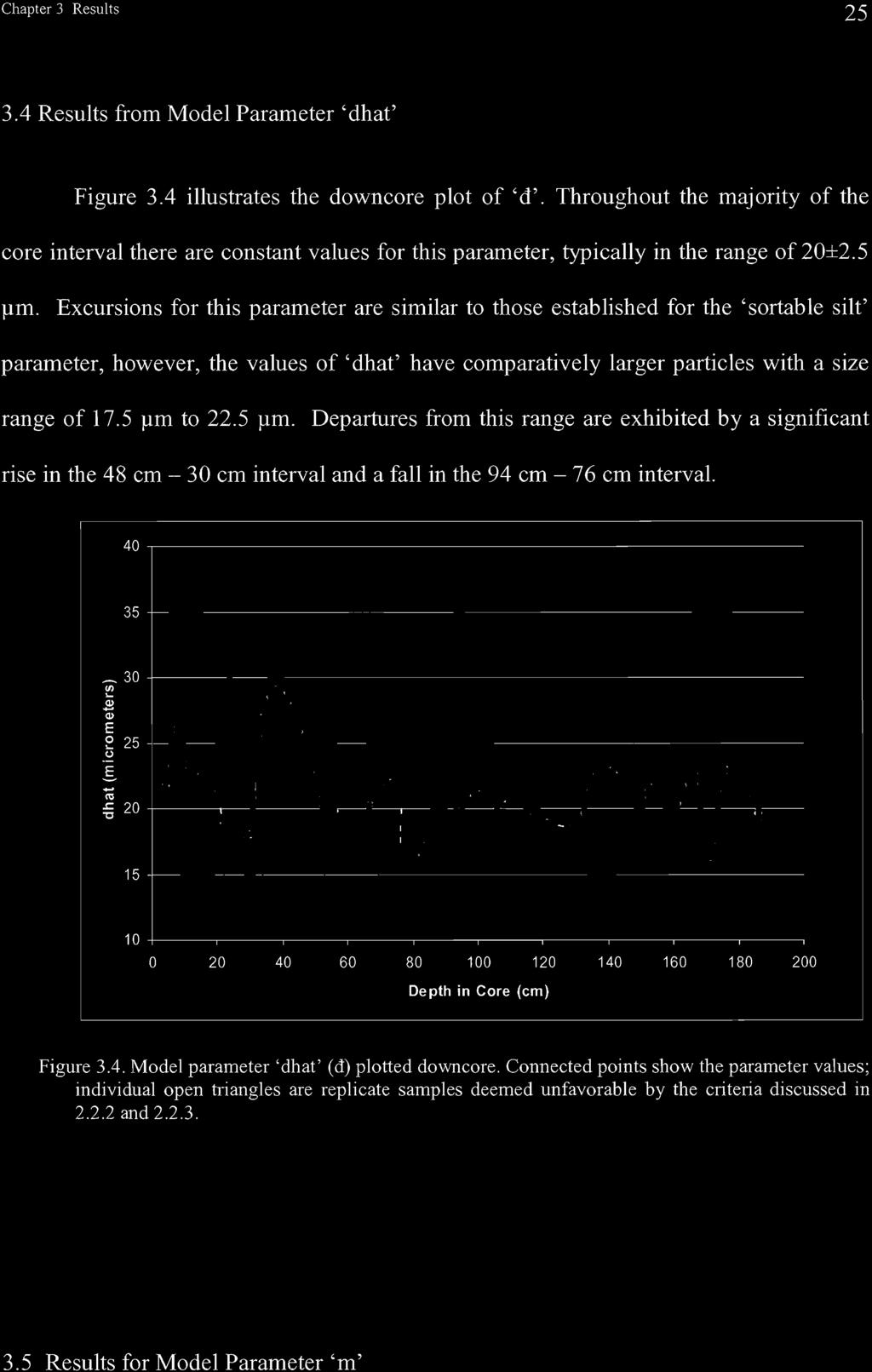
23
24 Chapter 2 Methods and Parameterizations i o (assuming 0 cm = 0 ky B.P.). Thus, this core chronology is a best estimate for the studied interval and cannot be considered as yielding exact ages. This cautionary note acknowledges one of the uncertainties regarding age resolution when considering core chronology between closely spaced age horizons described by Francois et al. (2004). Another caveat regarding the MAR method for estimating sediment flux, which this study addresses in more detail, is that it does not distinguish whether the sediment input was vertical or horizontal Thorium-230 Isotope vs. MAR Proxy The production of Thorium-230 (half-life = 75.2 ky) is from the decay of the conservative element Uranium-234 in seawater. Th-230 is insoluble in seawater and is readily adsorbed by settling particles in the water column (Bacon and Anderson 1982). Theoretically, the amount of Thorium-230 scavenged to the seafloor should equal the known amounts produced by the decay of Uranium-234 in the water column for a known time period and is thus useful in estimating the vertical flux of particles to the sea floor (Brown et al. 2002). In practice, observed Thorium concentration in sediments which deviate from the known production rate is accounted for by the sediment redistribution (Paytan et al. 2004). The total vertical flux is calculated as (Bacon and Anderson 1982); prfv-bulk = P*z/ xs230th(0) (2.7)
25 Chapter 2 Methods and Parameterizations ] Q where P is the production of Th-230 from U decay in the water column ( dpm m3y'), z is water depth (m), and xs230th(o) is the decay corrected excess of Thorium activity of the sample (dpm/g). Various authors (Francois et al. 2004; Suman and Bacon 1989) have devised and employed the parameter (vj/), termed the focusing factor, which identifies the ratio between measured MAR and Th-230-based estimates of vertical mass flux where; - MAR/prFv-bulk (2.8) This ratio is assumed to gauge the relative amount of sedimentary material ending up on the seafloor from vertical versus horizontal transport such that focusing factors exceeding 1 imply horizontal addition of sediment to the site. As a result, the focusing factor may serve as a valuable proxy for estimating sediment removal through winnowing or, on the other hand, sediment focusing during a particular interval ( Zabel et al. 2000). Regarding the region of this study, debate concerning the accuracy of Th-230- based vertical flux estimates has arisen5 (Francois et al. 2004; Paytan et al. 2004; Lyle et al. 2005). Specifically, the latter two papers suggest that sediment focusing is exaggerated by the dissolution of Th-230 in bed sediments. The dissolved Th-230 may leak back into the water column in areas of slowly accumulating surface sediments and then redeposit via particulate scavenging in areas of elevated vertical flux (Lyle et al. 2005). Furthermore, it has been suggested that Th-230 could be preferentially adsorbed 5 Kienast, S.S., Kienast,.M, Francois, R., Mix, A.C., Mollenhhauer G., Eglington, T.I., and S.E. Calvert 2005, submitted manuscript
26 Chapter 2 Methods and Parameterizations 90 onto particles with high surface areas (Lyle et al. 2005), so its flux may be affected by particle size distribution and packaging in the water column.
27

28

29


30

31

32
33
34


35


36
37

38


39


40
41
42
43
44
45


46
47
 and 88cm (red). The spectrum produced from the difference between them in the >2um fraction is shown with black triangles.")

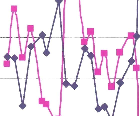
48 Chapter 4 Discussion n t k A A A & ized Volume (0 0 z ii* A A AA ± A^^AV A" A AAA A A AA A A AA A A A A O -i 1. DO Grain Diameter (micrometers) Figure 4.9 DIGS distribution plot for depths 106cm (green) and 88cm (red). The spectrum produced from the difference between them in the >2um fraction is shown with black triangles. The variability in 'm' is easily recognized by the differences in the slopes of the fine tails segments of the two DIGS spectra. The difference between them produces a relatively well-sorted distribution with a modal value around 10 urn. Biogenic opal is the frustules, or hard parts, of diatomaceous organisms, and smaller microscopic diatoms has diameters in the range of 5 urn - 20 urn (Seibold and Berger 1993; Brown et al. 2002), so a causal link is proposed. The correlation of 'm' and percent biogenic opal is caused by variable addition of a well-sorted distribution of diatom frustules. This idea agrees with the "size-composition slicing" parameter described by McCave et al. (1995) in determining the proportions and size characteristics of the spectrum. These authors
49 Chapter4 Discussion A'l suggest that, in theory, a component subtraction method could be employed to yield the size distribution of carbonate, opal, and terrigenous fraction. It should be cautioned, though, that the structure of opaline frustules is delicate and fragmentation is common in the water column and during burial. Furthermore, sample preparation procedure and handling (Sect. 2.2) could have broken down the opaline tests. A distinction, then, between intact frustules or fragments in the samples cannot be made. It is not within the scope of this study to comment on the compositional or structural state of diatom tests. Rather, in the analysis of grain size and their distribution in and between samples, coarsening of sediments is attributed, in part, to the opal fraction. Consider the difference between the two size distributions in Figure 4.9 as a function of a compositional change in time. Let the sample at 106 cm equal Tj and the sample at 88 cm equal T2. Based on the composition of the sediments in the core described in Section 2.1, the inorganic and calcite free fraction of the samples consists mainly of siliclastic material (L) and biogenic silica (Op). Since we can quantify the change in percent opal, it is worthwhile to perform a simple exercise to explore the covariate 'm' vs. percent opal relationship. To quantify the effect of a changing opal fraction, consider the addition of particles >2 urn between the two depths (Fig. 4.9) in terms of a change in time (T) of the total normalized volume percent (V) occupied by the silt sized particles from Vi( TI) to V2 (12) where; V, (T,) = L(Ti) + Op,(T,) = (4.1) and V2 (T2) = L(T2) + Op 2(T2) (4.2)
50 Chapter 4 Discussion A A Thus, from TI to T2 there is a 38 % increase in the total volume of silt sized particles. The corresponding increase in percent opal (Op 2 - Op i) is 87 %. A similar calculation was carried out for sample depths of 56 cm and 34 cm and yielded a 13 % decrease in total volume of silt fraction accompanied by a 19 % decrease in percent opal. Because these numbers are similar to within 1 order of magnitude and, as such, demonstrate a simple quantification of the observed covariate relationship, it is feasible to attribute some of the textural coarsening of the sediment sample to an increase in opal delivery to the site. Notably, the influence of the opal fraction on the DIGS distribution established in this study is not accurate enough to definitely partition size spectra into terrigenous and opal populations. The relative opal amount in the bulk composition is approximately 15 % and, as such, positioned close to the 10 % composition minimum for obtaining quantitatively precise estimates (McCave et al. 1995). Also, the overlapping sizes between the terrigenous and diatom/sponge spicule fractions make it difficult to distinguish between them. A sizing analysis with "compositional slicing" of bulk (including the dominating carbonate fraction) EEP deep-sea sediments may provide robust results and likely would offer insights into mass accumulation rates, productivity, and lysocline variability. The correlation between 'm' and percent biogenic opal breaks down for the 7 - ~1 ky B.P interval in the core (Fig. 4.8). One possibility for this departure is that a more gradual correlation may exist, similar to that of the ky B.P interval, but is not yet resolved in time. This seems unlikely based on a several factors. First, changes in 'm'
51 Chapter 4 Discussion A 5 coeval with changes in percent opal are exhibited on significantly shorter time scales in other parts of the core. Covariations of 'm' and percent opal in the rest of the core have periods of ~2 ky and thus a 6 ky interval should produce, in the least, a loose correlation. Second, excluding the single spike at ~2 ky B.P, the Holocene values of'm' remain quite stable while opal enrichment takes place. The latter point illustrates, most clearly, the complexity of the decoupling between 'm' and percent opal after 7.5 ky B.P. If it is accepted that an addition of opal coarsens the sample, logic follows that while enrichment in opal takes place but sediment texture remains the same, then some population of certain grain sizes in the pre-7.5 ky B.P interval must have been removed. As well, an addition of finer grains would produce the same end result. One possibility is that the current intensity, as discussed in the previous sections, played a role in fining the Holocene sediments. This would suggest a relatively slower and stable current regime to produce higher clay-to-silt ratios not observed in the top of the core (Fig. 4.4.). Although the 1-15 ky B.P interval is characterized by a regime with a slower background current, the scenario fails because flow variability during this period is assumed to have caused frequent events of erosion thereby advecting finer material away from the site. So if it is not an issue of hydrodynamic removal, per se, then another possibility is that coarser material in the pre-7.5 ky B.P period was not delivered to the site at all. Recall from Section that 'm' describes the size distribution of the parent material. The dominant modes of delivery for such hemi-pelagic materials to the ocean are either by glacial, fluvial or wind-driven agents of transport (Seibold and Berger 1993). Based on time and latitude, direct delivery of sediments by glaciers to the site is unlikely. Fluvial delivery is viable but is hard to constrain both in time and space when considering the abyssal
52 Chapter4 Discussion At* location and inferred hydrodynamic regime at the core site. Wind transport, however, can move fine material, and can vary on relatively short time-scales (Seibold and Berger 1993). For example, Anderson et al. (2006) delineate several features concerning terrestrially-derived aerosol delivery to the Equatorial Pacific: (1) dust in the sediment samples is compositionally similar to the hemi-pelagic sediments found in the coastal areas off of northern South America, (2) eolian transport of fine lithogenic material to the region has operated continuously, at least, since the LGM (~21 ky B.P) however, (3) fluxes of aerosols to the Equatorial Pacific decreased from the LGM to the Holocene by a range of 0.5 to a factor of 2 (Fig 4.10). Present day records of surface wind patterns off of northern South America show a NWN flow direction (Stuut and Lamy 2004, and references therein) in the general direction of the study site.


53
54
55
56
57
58
59
60
61
62
63
64
65
Supplementary Figure 1. New downcore data from this study. Triangles represent the depth of radiocarbon dates. Error bars represent 2 standard error
 Supplementary Figure 1. New downcore data from this study. Triangles represent the depth of radiocarbon dates. Error bars represent 2 standard error of measurement (s.e.m.). 1 Supplementary Figure 2. Particle
Laboratory#6 Sediment Particle Size Distribution and Turbidity Flows
 Laboratory#6 Sediment Particle Size Distribution and Turbidity Flows Although this laboratory will pertain to oceanic sediments similar processes can also be observed on land and other aquatic systems
SCOPE 35 Scales and Global Change (1988)
") 1. Types and origins of marine sediments 2. Distribution of sediments: controls and patterns 3. Sedimentary diagenesis: (a) Sedimentary and organic matter burial (b) Aerobic and anaerobic decomposition
1. Types and origins of marine sediments 2. Distribution of sediments: controls and patterns 3. Sedimentary diagenesis: (a) Sedimentary and organic matter burial (b) Aerobic and anaerobic decomposition
Ocean Sediments. Key Concepts
 Ocean Sediments Key Concepts 1. What are the processes that control what types of sediments are deposited in which places? 2. Conversely, how can we use the sedimentary record to figure out tectonic and
Making Sediments: Biogenic Production, Carbonate Saturation and Sediment Distributions
 Making Sediments: Biogenic Production, Carbonate Saturation and Sediment Distributions OCN 623 Chemical Oceanography Reading: Libes, Chapters 15 and 16 Outline I. Deep sea sedimentation Detrital sediments
Ocean Sediments OCN Nov 2016
 Ocean Sediments OCN 401 10 Nov 2016 Outline Significance & terms Origin & distribution of major types of marine sediments Delivery - dissolution destruction mid-ocean ridges Significance of ocean sediments
Marine Sediments. Introductory Oceanography. Ray Rector: Instructor
 Marine Sediments Introductory Oceanography Ray Rector: Instructor Ocean Basins are Vast Sinks for Huge Amounts of Sediment from Numerous Different Sources Four Major Types of Seafloor Sediments 1. Lithogenous
Sediment and Sedimentary rock
 Sediment and Sedimentary rock Sediment: An accumulation of loose mineral grains, such as boulders, pebbles, sand, silt or mud, which are not cemented together. Mechanical and chemical weathering produces
Supplementary Figure 1: Modern burial of organic carbon in deep sea sediment (gc m -2 a -1 ) 1.
 1.") Supplementary Figure 1: Modern burial of organic carbon in deep sea sediment (gc m -2 a -1 ) 1. Supplementary Figure 2: The 7 province maps used in this study. Each color corresponds to a single province:
Supplementary Figure 1: Modern burial of organic carbon in deep sea sediment (gc m -2 a -1 ) 1. Supplementary Figure 2: The 7 province maps used in this study. Each color corresponds to a single province:
Earth and Planetary Science Letters
 Earth and Planetary Science Letters 299 (2010) 138 149 Contents lists available at ScienceDirect Earth and Planetary Science Letters journal homepage: www.elsevier.com/locate/epsl The response of excess
Marine Sediments EPSS15 Spring 2017 Lab 4
 Marine Sediments EPSS15 Spring 2017 Lab 4 Why Sediments? Record of Earth s history - Tectonic plate movement - Past changes in climate - Ancient ocean circulation currents - Cataclysmic events 1 Classification
Processes affecting continental shelves
 Marine Sediments Continental Shelves Processes affecting continental shelves 1. Glaciation 2. Sea-level change (±130 m during continental glaciation) 3. Waves and currents 4. Sedimentation 5. Carbonate
Opal burial in the equatorial Atlantic Ocean over the last 30 ka: Implications for glacial-interglacial changes in the ocean silicon cycle
 Click Here for Full Article PALEOCEANOGRAPHY, VOL. 22,, doi:10.1029/2007pa001443, 2007 Opal burial in the equatorial Atlantic Ocean over the last 30 ka: Implications for glacial-interglacial changes in
Sediment and sedimentary rocks Sediment
 Sediment and sedimentary rocks Sediment From sediments to sedimentary rocks (transportation, deposition, preservation and lithification) Types of sedimentary rocks (clastic, chemical and organic) Sedimentary
Chapter 4 Marine Sediments
 Chapter 4 Marine Sediments Chapter Overview Marine sediments are important because contain a record of Earth history & provide clues to understand it Marine organism distribution Ocean floor movements
Chapter 6 Sedimentary and Metamorphic Rock
 Chapter 6 Sedimentary and Metamorphic Rock Weathering and Erosion Wherever rock is exposed at Earth s surface, it is continuously being broken down by weathering a set of physical and chemical processes
Reading Material. See class website. Sediments, from Oceanography M.G. Gross, Prentice-Hall
 Reading Material See class website Sediments, from Oceanography M.G. Gross, Prentice-Hall Materials filling ocean basins Dissolved chemicals especially from rivers and mid-ocean ridges (volcanic eruptions)
Marine Sediments Chapter Four Chapter Overview Marine Sediments Approaching the bottom (Alvin) Marine Sediments Classification of Marine Sediments
 Marine Sediments Classification of Marine Sediments") 1 2 3 4 5 6 7 8 9 10 11 Marine Sediments Chapter Four Chapter Overview Marine sediments contain a record of Earth history. Marine sediments provide many important resources. Marine sediments have origins
1 2 3 4 5 6 7 8 9 10 11 Marine Sediments Chapter Four Chapter Overview Marine sediments contain a record of Earth history. Marine sediments provide many important resources. Marine sediments have origins
UNIT 4 SEDIMENTARY ROCKS
 UNIT 4 SEDIMENTARY ROCKS WHAT ARE SEDIMENTS Sediments are loose Earth materials (unconsolidated materials) such as sand which are transported by the action of water, wind, glacial ice and gravity. These
Chapter 3 Sedimentation of clay minerals
 Chapter 3 Sedimentation of clay minerals 3.1 Clay sedimentation on land 3.2 From land to sea 3.3 Clay sedimentation in the sea 1 3.1 Clay sedimentation on land Deserts Glaciers Rivers Lacustrine 2 University
Question. What caused the recent explosive eruptions of hot ash and gas at Kilauea s Halema uma u crater:
 OCN 201 Deep Sea Sediments Question What caused the recent explosive eruptions of hot ash and gas at Kilauea s Halema uma u crater: A. The interaction of lava with seawater B. Drainage of the lava lake
2/16/2014. Chapter Overview. Marine Sediments. Approaching the bottom (Alvin) Classification of Marine Sediments. Marine Sediments
 Classification of Marine Sediments. Marine Sediments") Chapter Overview Marine sediments contain a record of Earth history. Marine sediments provide many important resources. Marine sediments have origins from a variety of sources. Marine Sediments Chapter
Chapter Overview Marine sediments contain a record of Earth history. Marine sediments provide many important resources. Marine sediments have origins from a variety of sources. Marine Sediments Chapter
OCN 201: Deep-Sea Sediments
 OCN 201: Deep-Sea Sediments Eric Heinen De Carlo, F2011 Where is the Sediment? Continental Margins: 87% (covers ~21% of ocean area) Deep-ocean floor: 13% ~21% ~87% Sediment Deposition Rates (time to deposit
Elements of Ocean Engineering Prof. Ashoke Bhar Department of Ocean Engineering and Naval Architecture Indian Institute of Technology, Kharagpur
 Elements of Ocean Engineering Prof. Ashoke Bhar Department of Ocean Engineering and Naval Architecture Indian Institute of Technology, Kharagpur Lecture - 4 Physical Oceanography - IV (Refer Slide Time:
Ocean Sciences 101 The Marine Environment Midterm #1
 Part 1. Multiple Choice Questions. Choose the one best answer from the list, and write the correct letter legibly in the blank to the left of the question. 2 points each. 1. Many of the unique properties
Ratio of coccolith CaCO 3 to foraminifera CaCO 3 in late Holocene deep sea sediments
 PALEOCEANOGRAPHY, VOL. 24,, doi:10.1029/2009pa001731, 2009 Ratio of coccolith CaCO 3 to foraminifera CaCO 3 in late Holocene deep sea sediments Wallace Broecker 1 and Elizabeth Clark 1 Received 30 December
The Ocean Floor Chapter 14. Essentials of Geology, 8e. Stan Hatfield and Ken Pinzke Southwestern Illinois College
 The Ocean Floor Chapter 14 Essentials of Geology, 8e Stan Hatfield and Ken Pinzke Southwestern Illinois College The vast world ocean Earth is often referred to as the water planet 71% of Earth s surface
Announcements. First problem set due next Tuesday. Review for first exam next Thursday. Quiz on Booth (1994) after break today.
 after break today.") Announcements First problem set due next Tuesday. Review for first exam next Thursday. Quiz on Booth (1994) after break today. Intertidal, Lowes Cove, ME Marine Sediments: Clues to the ocean s past There
Announcements First problem set due next Tuesday. Review for first exam next Thursday. Quiz on Booth (1994) after break today. Intertidal, Lowes Cove, ME Marine Sediments: Clues to the ocean s past There
A Broecker Brief Origin of the Atlantic s glacial age lower deep water
 A Broecker Brief Origin of the Atlantic s glacial age lower deep water Today s deep Atlantic shows no hint of nutrient stratification (see Figure 1). By contrast, during the last glacial maximum (LGM),
Essentials of Oceanography
 Chapter Chapter 1 4 Clickers Lecture Essentials of Oceanography Eleventh Edition Marine Sediments Alan P. Trujillo Harold V. Thurman Chapter Overview Marine sediments contain a record of Earth history.
EPSS 15 Fall 2017 Introduction to Oceanography. Marine Sediments
 EPSS 15 Fall 2017 Introduction to Oceanography Marine Sediments INTRODUCTION There are two basic methods used for classification of marine sediments: genetic and descriptive. Genetic classifications distinguish
Lecture 26: Marine Geology Read: Chapter 21 Homework due December 3
 Learning Objectives (LO) Lecture 26: Marine Geology Read: Chapter 21 Homework due December 3 What we ll learn today:! 1. Describe the world s five oceans! 2. Understand patterns of ocean circulation! 3.
Sediments, Sedimentation, and Paleoceanography. -Types of sediments -Distribution of ocean sediments and Processes of sedimentation -Paleoceanography
 Sediments, Sedimentation, and Paleoceanography -Types of sediments -Distribution of ocean sediments and Processes of sedimentation -Paleoceanography Sediments Sources of sediment: 1. living organisms (biogenic:
To get you thinking Explain how these different layers of rock formed? Why are these layers different colors? Sedimentary Rocks
 To get you thinking Explain how these different layers of rock formed? Why are these layers different colors? Sedimentary Rocks Bryce Canyon, Utah Badlands, South Dakota Weathering Whenever rock is exposed
Lecture Outline Wednesday - Friday February 14-16, 2018
 Lecture Outline Wednesday - Friday February 14-16, 2018 Quiz 2 scheduled for Friday Feb 23 (Interlude B, Chapters 6,7) Questions? Chapter 6 Pages of the Past: Sedimentary Rocks Key Points for today Be
Lecture Outlines PowerPoint. Chapter 13 Earth Science 11e Tarbuck/Lutgens
 Lecture Outlines PowerPoint Chapter 13 Earth Science 11e Tarbuck/Lutgens 2006 Pearson Prentice Hall This work is protected by United States copyright laws and is provided solely for the use of instructors
Iron control of past productivity in the coastal upwelling system off the Atacama Desert, Chile
 PALEOCEANOGRAPHY, VOL. 19,, doi:10.1029/2004pa001006, 2004 Iron control of past productivity in the coastal upwelling system off the Atacama Desert, Chile Laurent Dezileau, 1,2 Osvaldo Ulloa, 1 Dierk Hebbeln,
13. Sedimentary Rocks I (p )
") 13. Sedimentary Rocks I (p. 194-208) Sediment Deposition Weathering results in rock being broken down into smaller fragments, called regolith. This regolith is then broken down to form soil. The regolith
13. Sedimentary Rocks I (p. 194-208) Sediment Deposition Weathering results in rock being broken down into smaller fragments, called regolith. This regolith is then broken down to form soil. The regolith
NC Earth Science Essential Standards
 NC Earth Science Essential Standards EEn. 2.1 Explain how processes and forces affect the Lithosphere. EEn. 2.1.1 Explain how the rock cycle, plate tectonics, volcanoes, and earthquakes impact the Lithosphere.
Foundations of Earth Science, 6e Lutgens, Tarbuck, & Tasa
 Foundations of Earth Science, 6e Lutgens, Tarbuck, & Tasa Oceans: The Last Frontier Foundations, 6e - Chapter 9 Stan Hatfield Southwestern Illinois College The vast world ocean Earth is often referred
Topic 6: Weathering, Erosion and Erosional-Deposition Systems (workbook p ) Workbook Chapter 4, 5 WEATHERING
 Workbook Chapter 4, 5 WEATHERING") Topic 6: Weathering, Erosion and Erosional-Deposition Systems (workbook p. 95-125) Workbook Chapter 4, 5 THE BIG PICTURE: Weathering, erosion and deposition are processes that cause changes to rock material
Topic 6: Weathering, Erosion and Erosional-Deposition Systems (workbook p. 95-125) Workbook Chapter 4, 5 THE BIG PICTURE: Weathering, erosion and deposition are processes that cause changes to rock material
Lab 7: Sedimentary Structures
 Name: Lab 7: Sedimentary Structures Sedimentary rocks account for a negligibly small fraction of Earth s mass, yet they are commonly encountered because the processes that form them are ubiquitous in the
Sedimentary Rocks. Origin, Properties and Identification. Physical Geology GEOL 100. Ray Rector - Instructor
 Sedimentary Rocks Origin, Properties and Identification Physical Geology GEOL 100 Ray Rector - Instructor Sedimentary Rock Origin and Identification Lab Pre-Lab Internet Link Resources 1) http://www.rockhounds.com/rockshop/rockkey/index.html
The Marine Environment
 The Marine Environment SECTION 16.1 Shoreline Features In your textbook, read about erosional landforms, beaches, estuaries, longshore currents, and rip currents. For each statement below, write or. 1.
EPS 50 Lab 4: Sedimentary Rocks
 Name: EPS 50 Lab 4: Sedimentary Rocks Grotzinger and Jordan, Chapter 5 Introduction In this lab we will classify sedimentary rocks and investigate the relationship between environmental conditions and
SUPPLEMENTARY INFORMATION
 SUPPLEMENTARY INFORMATION DOI: 1.138/NGEO168 "Strength and geometry of the glacial Atlantic Meridional Overturning Circulation" S2 Map of core locations Core locations of the Holocene and LGM 231 / 23
A comparison of multiple proxies for export production in the equatorial Pacific
 PALEOCEANOGRAPHY, VOL. 19,, doi:10.1029/2004pa001005, 2004 A comparison of multiple proxies for export production in the equatorial Pacific Kristen B. Averyt and Adina Paytan Department of Geological and
Global phosphorus cycle
 Global phosphorus cycle OCN 623 Chemical Oceanography 11 April 2013 2013 Arisa Okazaki and Kathleen Ruttenberg Outline 1. Introduction on global phosphorus (P) cycle 2. Terrestrial environment 3. Atmospheric
Depositional Environment
 Depositional Environment Sedimentary depositional environment describes the combination of physical, chemical and biological processes associated with the deposition of a particular type of sediment. Types
Quantifying the opal belt in the Atlantic and southeast Pacific sector of the Southern Ocean by means of 230 Th normalization
 GLOBAL BIOGEOCHEMICAL CYCLES, VOL. 19,, doi:10.1029/2005gb002465, 2005 Quantifying the opal belt in the Atlantic and southeast Pacific sector of the Southern Ocean by means of 230 Th normalization Walter
Chapter 9 Lecture Outline. Oceans: The Last Frontier
 Chapter 9 Lecture Outline Oceans: The Last Frontier The Vast World Ocean Earth is referred to as the blue planet 71% of Earth s surface is oceans and marginal seas Continents and islands comprise the remaining
Early diagenesis in marine sediments
 Early diagenesis in marine sediments Why study this part of the ocean? Particle flux to the sea floor ocean surface sediments early diagenesis layer Biogeochemical reactions Why study this part of the
Ice Ages and Changes in Earth s Orbit. Topic Outline
 Ice Ages and Changes in Earth s Orbit Topic Outline Introduction to the Quaternary Oxygen isotopes as an indicator of ice volume Temporal variations in ice volume Periodic changes in Earth s orbit Relationship
Directed Reading. Section: The Water Planet. surface is called the a. Earth s ocean. b. Pacific Ocean. c. salt-water ocean. d. global ocean.
 Skills Worksheet Directed Reading Section: The Water Planet 1. The body of salt water covering nearly three-quarters of the Earth s surface is called the a. Earth s ocean. b. Pacific Ocean. c. salt-water
B-1. Attachment B-1. Evaluation of AdH Model Simplifications in Conowingo Reservoir Sediment Transport Modeling
 Attachment B-1 Evaluation of AdH Model Simplifications in Conowingo Reservoir Sediment Transport Modeling 1 October 2012 Lower Susquehanna River Watershed Assessment Evaluation of AdH Model Simplifications
17. DATA REPORT: CARBONATE, ORGANIC CARBON, AND OPAL CONCENTRATIONS SOUTHWEST AFRICA MARGIN 1
 Wefer, G., Berger, W.H., and Richter, C. (Eds.) Proceedings of the Ocean Drilling Program, Scientific Results Volume 175 17. DATA REPORT: CARBONATE, ORGANIC CARBON, AND OPAL CONCENTRATIONS AND ORGANIC
Quantifying the opal belt in the Atlantic and Southeast. Pacific Sector of the Southern Ocean by means of 230 Thnormalization
 Quantifying the opal belt in the Atlantic and Southeast Pacific Sector of the Southern Ocean by means of 230 Thnormalization Walter Geibert* 1, Michiel M. Rutgers van der Loeff 1, Regina Usbeck 2, Rainer
Chapter 6 9/25/2012. Weathering, Erosion and Soils. Introduction. How Are Earth Materials Altered? Introduction. How Are Earth Materials Altered?
 Chapter 6 Introduction Rocks and minerals are disintegrated and decomposed by the processes of mechanical and chemical weathering. Weathering, Erosion and Soils This breakdown occurs because the parent
Earth s Dynamic Surface
 Earth s Dynamic Surface Key Concepts What is the difference between physical and chemical weathering? How do water, ice, and wind change Earth s surface? Changing Earth s Surface What do you think? Read
Lesson II. Biological components of sediments and nutrient ratio considerations
 Lesson II Biological components of sediments and nutrient ratio considerations Sediment classification Silica cycle The steady state concept Feedbacks Controls on ocean sedimentation Sediment classification?
Erosion and Deposition
 Erosion and Deposition The Erosion-Deposition Process What do you think? Read the two statements below and decide whether you agree or disagree with them. Place an A in the Before column if you agree with
Actual bathymetry (with vertical exaggeration) Geometry of the ocean 1/17/2018. Patterns and observations? Patterns and observations?
 Geometry of the ocean 1/17/2018. Patterns and observations? Patterns and observations?") Patterns and observations? Patterns and observations? Observations? Patterns? Observations? Patterns? Geometry of the ocean Actual bathymetry (with vertical exaggeration) Continental Continental Basin
Patterns and observations? Patterns and observations? Observations? Patterns? Observations? Patterns? Geometry of the ocean Actual bathymetry (with vertical exaggeration) Continental Continental Basin
Processes Affecting Exchange of Mud Between Tidal Channels and Flats
 DISTRIBUTION STATEMENT A: Approved for public release; distribution is unlimited. Processes Affecting Exchange of Mud Between Tidal Channels and Flats Timothy G. Milligan and Brent A. Law Fisheries and
An Investigation of Antarctic Circumpolar Current Strength in Response to Changes in Climate. Presented by Matt Laffin
 An Investigation of Antarctic Circumpolar Current Strength in Response to Changes in Climate Presented by Matt Laffin Presentation Outline Introduction to Marine Sediment as a Proxy Introduction to McCave
Sedimentary Features in Expedition 341 Cores: A Guide to Visual Core Description
 Sedimentary Features in Expedition 341 Cores: A Guide to Visual Core Description 1. Typical Deep water Sediments in the Gulf of Alaska 1A & B: Mud and 1C: Laminated mud Description: Mud is representative
The physical breakdown and chemical alteration of rocks and minerals at or near Earth s surface.
 The physical breakdown and chemical alteration of rocks and minerals at or near Earth s surface. The material that is chemically and mechanically weathered to yield sediment and soil. Regolith consisting
Your teacher will show you a sample or diagram of each, and show you a settling column. Draw these, and label your diagrams (8 pts) Ungraded:
 Ungraded:") From Sand to Stone: How do we recognize and interpret sedimentary rocks in the rock record? (Based closely on the University of Washington ESS 101 Lab 5: Sedimentary Rocks) Introduction: This lab consists
From Sand to Stone: How do we recognize and interpret sedimentary rocks in the rock record? (Based closely on the University of Washington ESS 101 Lab 5: Sedimentary Rocks) Introduction: This lab consists
33. EVIDENCE FOR DISSOLUTION AND SORTING OF PLANKTONIC FORAMINIFERS IN PLEISTOCENE SEDIMENTS AT HOLE 708A 1
 Duncan, R. A., Backman, J., eterson, L. C, et al., roceedings of the Ocean Drilling rogram, Scientific Results, Vol.. EVIDENCE FOR DISSOLUION AND SORING OF LANKONIC FORAMINIFERS IN LEISOCENE SEDIMENS A
Diatom productivity in the equatorial Pacific Ocean from the last glacial period to the present: A test of the silicic acid leakage hypothesis
 Click Here for Full Article PALEOCEANOGRAPHY, VOL. 21,, doi: 10.1029/2006PA001282, 2006 Diatom productivity in the equatorial Pacific Ocean from the last glacial period to the present: A test of the silicic
Flocculation, Optics and Turbulence in the Community Sediment Transport Model System: Application of OASIS Results
 DISTRIBUTION STATEMENT A: Approved for public release; distribution is unlimited. Flocculation, Optics and Turbulence in the Community Sediment Transport Model System: Application of OASIS Results Emmanuel
4. The map below shows a meandering stream. Points A, B, C, and D represent locations along the stream bottom.
 1. Sediment is deposited as a river enters a lake because the A) velocity of the river decreases B) force of gravity decreases C) volume of water increases D) slope of the river increases 2. Which diagram
Earth s Seafloors. Ocean Basins and Continental Margins. Introductory Oceanography Ray Rector - Instructor
 Earth s Seafloors Ocean Basins and Continental Margins Introductory Oceanography Ray Rector - Instructor OCEAN BASINS and CONTINENTAL PLATFORMS Key Concepts I. Earth s rocky surface covered by of two types
The Sea Floor and Its Sediments OCEA 101
 The Sea Floor and Its Sediments OCEA 101 Measuring the depth of the ocean 85BC Posidonius measured depth of Med using rope and rock as ~2000m. Same idea used for next 2000 yrs using graduated ropes and
The Impact of Changing Winds on Estuarine Evolution, Copano Bay, TX
 The Impact of Changing Winds on Estuarine Evolution, Copano Bay, TX Purpose: The fulfillment of partial requirements for the Degree of Master of Science in Geology Oklahoma State University, Stillwater
Lecture 05: Ocean Basins. Hypsometric Curve. Consider Ocean Basins: What is the elevation of Chambana?
 Lecture 05: Ocean Basins 1 Hypsometric Curve What is the elevation of Chambana? Shows distribution of surface relative to sea level ~67% below sea level Mean ocean depth ~ -3.7 km (well below sea level)
1/31/2013. Weathering Includes Physical, Chemical, Biological processes. Weathering Mechanisms. Wind abrasion forming Ventifacts
 Monument Valley, Utah. What weathering processes contributed to the development of these remarkable rock formations? Weathering Includes Physical, Chemical, Biological processes Weathering Mechanisms Physical
INSIGHTS INTO PARTICLE FORMATION AND REMINERALIZATION USING THE SHORT-LIVED RADIONUCLIDE, THORUIM-234 LA Woods Hole, MA 02543
 1 1 2 3 4 INSIGHTS INTO PARTICLE FORMATION AND REMINERALIZATION USING THE SHORT-LIVED RADIONUCLIDE, THORUIM-234 Kanchan Maiti 1,2, Claudia R. Benitez-Nelson 3 and Ken O. Buesseler 2 5 6 7 8 9 10 1 Department
ESC102. Sedimentary Rocks. Our keys to the past. Monday, February 11, 13
 ESC102 Sedimentary Rocks Our keys to the past Sedimentary Rocks Sedimentary rocks are rocks that form through the accumulation of sediment and the process of lithification. Lithification occurs after deposition
Sediments and Sedimentary Rocks
 Sediments and Sedimentary Rocks (Shaping Earth s Surface, Part 2) Science 330 Summer 2005 What is a sedimentary rock? Products of mechanical and chemical weathering Account for about 5 percent of Earth
Chapter 5. The Sedimentary Archives
 Chapter 5 The Sedimentary Archives Factors affecting Sedimentary Characteristics 1. Tectonic setting 2. Physical, chemical, and biological processes in the depositional environment 3. Method of sediment
Mechanical Weathering
 Weathering is the disintegration and decomposition of material at or near the surface. Erosion is the incorporation and transportation of material by a mobile agent, usually water, wind, or ice. Geologists
Physiography Ocean Provinces p. 1 Dimensions p. 1 Physiographic Provinces p. 2 Continental Margin Province p. 2 Deep-Ocean Basin Province p.
 Physiography Ocean Provinces p. 1 Dimensions p. 1 Physiographic Provinces p. 2 Continental Margin Province p. 2 Deep-Ocean Basin Province p. 2 Mid-Ocean Ridge Province p. 3 Benthic and Pelagic Provinces
fluxes during the late Quaternary
 PALEOCEANOGRAPHY, VOL. 19,, doi:10.1029/2003pa000939, 2004 230 Th normalization: An essential tool for interpreting sedimentary fluxes during the late Quaternary Roger Francois, 1 Martin Frank, 2 Michiel
Oceanography is the scientific study of oceans Oceans make up over 70% of the Earth s surface
 Oceanography Oceanography is the scientific study of oceans Oceans make up over 70% of the Earth s surface An ocean must be large and have features which set it apart from other oceans (currents, water
Weathering, Erosion and Deposition
 Weathering, Erosion and Deposition Shaping the Earth s Surface Weathering the process of breaking down rocks into smaller fragments Erosion the transport of rock fragments from one location to another
Bowen s Chemical Stability Series
 Lab 5 - Identification of Sedimentary Rocks Page - Introduction Sedimentary rocks are the second great rock group. Although they make up only a small percentage of the rocks in the earth s crust (~5%)
Geology Merit Badge Workbook
 Merit Badge Workbook This workbook can help you but you still need to read the merit badge pamphlet. This Workbook can help you organize your thoughts as you prepare to meet with your merit badge counselor.
GEOLOGY MEDIA SUITE Chapter 5
 UNDERSTANDING EARTH, SIXTH EDITION GROTZINGER JORDAN GEOLOGY MEDIA SUITE Chapter 5 Sedimentation Rocks Formed by Surface Processes 2010 W.H. Freeman and Company Mineralogy of sandstones Key Figure 5.12
Exercise 3 Texture of siliciclastic sediments
 Exercise 3 Texture of siliciclastic sediments Siliciclastic sediments are derived from the weathering and erosion of preexisting rocks. Once a sedimentary particle is loosened from its parent rock, it
Sedimentary Rocks. Origin, Properties and Identification. Geology Laboratory GEOL 101 Lab Ray Rector - Instructor
 Sedimentary Rocks Origin, Properties and Identification Geology Laboratory GEOL 101 Lab Ray Rector - Instructor Sedimentary Rock Origin and Identification Lab Pre-Lab Internet Link Resources 1) http://www.rockhounds.com/rockshop/rockkey/index.html
G 3. AN ELECTRONIC JOURNAL OF THE EARTH SCIENCES Published by AGU and the Geochemical Society
 Geosystems G 3 AN ELECTRONIC JOURNAL OF THE EARTH SCIENCES Published by AGU and the Geochemical Society Forum Volume 5, Number 4 6 April 2004 Q04002, doi:10.1029/2003gc000670 ISSN: 1525-2027 Switching
Engineering Geology ECIV 3302
 Engineering Geology ECIV 3302 Instructor : Dr. Jehad Hamad 2019-2018 Chapter (5) Weathering & Soil Chapter 5: Weathering, Soil, and Mass Wasting External processes include : (1) Weathering (2) Mass wasting
The Marine Environment
 The Marine Environment SECTION 16.1 Shoreline Features In your textbook, read about erosional landforms, beaches, estuaries, longshore currents, and rip currents. For each statement below, write true or
Sedimentary Rocks. All sedimentary rocks begin to form when existing rocks are broken down into sediments Sediments are mainly weathered debris
 Rocks! Objectives Describe the major processes involved in the formation of sedimentary rock Distinguish between clastic sedimentary rocks and chemical sedimentary rocks Identify the features that are
Where is all the water?
 Where is all the water? The distribution of water at the Earth's surface % of total Oceans 97.25 Ice caps and glaciers 2.05 Groundwater 0.68 Lakes 0.01 Soils 0.005 Atmosphere (as vapour) 0.001 Rivers 0.0001
Name Class Date. In your textbook, read about the nature of igneous rocks. Use each of the terms below just once to complete the following statements.
 CHAPTER 5 Igneous Rocks SECTION 5.1 What are igneous rocks? In your textbook, read about the nature of igneous rocks. Use each of the terms below just once to complete the following statements. basaltic
PSRD: A Complication in Determining the Precise Age of the Solar System
 January 21, 2010 A Complication in Determining the Precise Age of the Solar System --- The presence of short-lived isotope Curium-247 in the early Solar System complicates the job of dating the earliest
Landslides and Ground Water Permeability with Respect to the. Contact Point of Glacial Lake Vermont and the Champlain Sea
 Landslides and Ground Water Permeability with Respect to the Contact Point of Glacial Lake Vermont and the Champlain Sea Sediments at Town Line Brook, Winooski, VT Michala Peabody Lara Vowles Abstract:
Ocean Sciences 101 The Marine Environment OCEA 101 THE MARINE ENVIRONMENT MID-TERM EXAM
 OCEA 101 THE MARINE ENVIRONMENT MID-TERM EXAM Part I. Multiple Choice Questions. Choose the one best answer from the list, and write the letter legibly in the blank to the left of the question. 2 points
Sediment. Weathering: mechanical and chemical decomposition and disintegration of rock and minerals at the surface
 Sediment Some basic terminology Weathering: mechanical and chemical decomposition and disintegration of rock and minerals at the surface Erosion: removal of weathered rock and minerals from one place to