Development and Application of Groundwater Flow and Solute Transport Models. Randolf Rausch
|
|
|
- Anthony Phillips
- 5 years ago
- Views:
Transcription
1 Development and Application of Groundwater Flow and Solute Transport Models Randolf Rausch
2 Overview Groundwater Flow Modeling Solute Transport Modeling Inverse Problem in Groundwater Modeling


3 Groundwater Flow Modeling


4 Flow modeling in fractured and karstified media Model approaches for fractured / karstified sytems Double porosity flow models Parameter identification


5 Problem: Flow in fractures and pipes

6 Large dynamics in head and discharge

7 Matrix and pipe network
8 Matrix and pipe network + observation wells
9 Interpolated head distribution
10 Interpolated head distribution and reality


11 Classification of fractured media Granite Sandstone Limestone Karstified Limestone Mesh of fractures and impermeable matrix Fractures with permeable matrix Fractured system with minor karstification Conduit system with a karstified rock matrix Waste Disposal Water Supply

12 Possible model approaches Single Porosity Model Double Porosity Model Discrete model Equivalent continuum Two coupled fracture systems Fracture network and continuum Two equivalent continua

13 Double continuum flow model Karst system Double continuum system Linear exchange depends on: head difference exchange coefficient Different aquifer parameters: Hydraulic conductivity low in fissured system high in conduit system Storage coefficient: high in fissured system low in conduit system
14 System of coupled flow equations: ( ) ( ) (x,y,z,t) f and h (x,y,z,t) f h Solution : h h W t h S z h k z y h k y x h k x h h W t h S z h k z y h k y x h k x b a b a b b b b b zz b b yy b b xx b a a a a a a zz a a yy a a xx = = α + = α + =


15 Parameter identification interpretation of heads Classification by standard deviation heads from fracture system: large standard deviation same range as continuum b (conduit system) heads from matrix system: only one point with same standard deviation as continuum a (fissured system)

16 Double continuum model: Stubersheimer Alb steady state model calibration using measured head and discharge data distribution of hydraulic conductivity sensitivity study for transient flow: simulate the measured characteristics to investigate the exchange behavior


17 Simulation results Double continuum model shows same characteristics as measured data Heads Transient exchange between fracture and matrix system Continuum a: smooth curve Continuum b: large dynamics Discharge


18 Solute Transport Modeling
19 Application of solute transport models interpretation of concentration data mass balance of contaminants predictions of pollutant plumes design of pump and treat management planning of monitoring strategy risk assessment in case of waste disposals

20 Simulation of a contamination plume

21 Relation between groundwater flow and transport models
22 Representation of transport processes Transport in 1-D-aquifer Advection Advection + Dispersion (+ Diffusion) Advection + Dispersion + Adsorption Advection + Dispersion + Adsorption + Decay
23 Transport equation c t = q n ( D c uc) + σ c c ) f ( in The temporal change of pollutant mass for every volume element is given by the in- / outflows from Dispersion Advection Reaction Sources / Sinks ( D c) ( uc) σ q n f ( c cin)
24 1-D transport equation c t = D 2 c 2 x u c x Measure for the relation advective / dispersive transport is given by the PECLET-number: P e = L u DL Lu = αl u L: typical length scale of transport problem P e = 0 pure dispersive transport P e = pure advective transport
25 Solution methods for transport equation - Analytical solutions Simple flow conditions / simple initial and boundary conditions, homogeneity - Neglecting Diffusion / Dispersion Path lines, travel times, concentration along path lines - Numerical Solutions Grid methods: FD, FV, FE Particle-Tracking Methods: MOC, Random-Walk


26 Numerical solution methods Grid Methods: Finite Differences Finite Elements Finite Volumes Particle-Tracking Methods: Method of Characteristics Random-Walk-Method

27 Problems with grid methods - Numerical dispersion - Oscillations Possible solution: grid refinement
28 Possible solution: adaptive grid Adaptive gridding methods consists in dynamically refining the grid size to eliminate numerical dispersion Example of grid refinement

29 Adaptive refinement: nested iteration
30 Error indicator for adaptive griding The selection of elements for refinement and coarsening is based on an error indicator. Typical error indicators are The gradient of the solution c, Concentration variation between neighbor elements. In case of time step methods the solution of the proceeding time step is considered.

31 Example of an adaptive refined grid from a simulation


32 The Inverse Problem in Groundwater Modeling
33 Direct problem Given: Wanted: parameters, boundary and initial conditions head / flow distribution (or concentration) Usually parameters are not known completely! Therefore: Calibration (i.e. completion of parameters) using measurements of heads / flows (or concentration) is required.
34 Inverse problem Given: Wanted: heads / flows, (concentrations) parameter distribution Problem: Ways out: ill-posedness No unique solution may exist Measurement errors make result unreliable Reduction of degrees of freedom and regression Introduction of a priori knowledge Joint use of head, flow and / or concentration measurements Estimate of uncertainty

35 Example for non uniqueness of the inverse problem Q = B T (h 1 -h 2 )/L Where: Q: discharge B: width T: transmissivity h: head L: length Identification problem of steady state calibration. Every T leads to the same head distribution, only Q varies!
36 Criterion for goodness of fit (maximum likelihood) Without prior knowledge minimize S( p = measured computed 2 1,..., pm) ( fi fi ( pk )) i or with a priori knowledge S( p = measured computed 2 prior 2 1,..., pm) ( fi fi ( pk )) wi + ( p j p j ) i j w i w j (p j parameter, f i heads or flow, w i weights) Minimization can be done manually ( trial and error ) or by automatic methods: e.g. MARQUARDT-LEVENBERG algorithm
 Interpolation and pivot")
37 Concepts for parameterization of spatial structures Reduction of degrees of freedom by: Zonation (N zones) Interpolation and pivot points


38 Spatial transmissivity distribution (Jurassic karst aquifer) Frequency distributions: all data valleys plateau

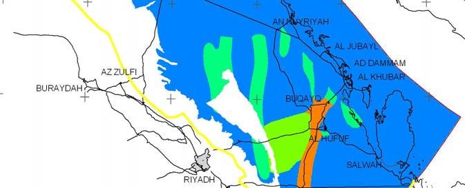
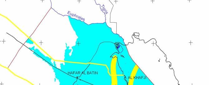
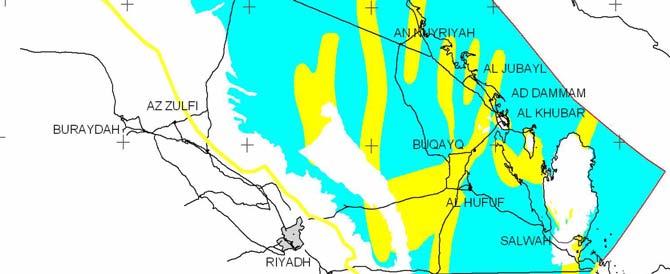
39 Umm Er Radhuma aquifer system in Saudi Arabia

40 Euphrates Geological and hydrogeological units of the Umm Er Radhuma aquifer system Tigris I R A N Tdm I R A Q Q K U W A I T Ka Tu HAFAR AL BATIN AL KHAFJI ARABIAN GULF AN NUYRIYAH Tsm AL JUBAYL BURAYDAH AZ ZULFI BUQAYQ AD DAMMAM AL KHUBAR BAHRAIN Tdm Ka AL HUFUF QATAR RIYADH AL KHARJ Tr HARAD Q SALWAH U. A. E. Legend YABRIN Q Quaternary Tu Tsm Tsm Neogene LAYLA Tdm Dammam Tr Rus Tu Umm Er Radhuma Ka Aruma AS SULAYYIL Kilometers
41 Geological structure and stratification Geological Cross Sections


42 Geological structure and tectonic features Main Anticlinal Structures and Faults Colored sub crop surface: base of Umm Er Radhuma


43 Vertical hydraulic conductivity distribution Rus aquitard Dammam / Neogene

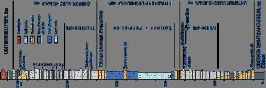


44 Muschelkalk lithology
45 Time needed for the change of rocks within an aquifer depends on rock type Important features for the Muschelkalk are: - the dissolution of evaporites, - and the karstification of carbonate rocks. The processes depend on the exposition to the ground surface.


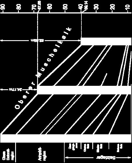
46 Thickness reduction of the Mittlerer Muschelkalk by salt and sulphate dissolution


47 Consequence: 50 m thickness reduction within a relative short time Cracking of rocks Intensification of fractures Acceleration of karstification
48 What are the major processes for dissolution? The main factor is the exposition to the ground surface. The exposition to the ground surface depends on the cuesta development.

49 Cuesta development in Baden-Württemberg Location of cuestas and rivers during Oligocene and Late Miocene (34 20 Ma)

50 Cuesta development in Baden-Württemberg Location of cuestas and rivers during Upper Miocene (11 5 Ma)

51 Cuesta development in Baden-Württemberg Location of cuestas and rivers during Lower Pleistocene ( Ma)


52 Cuesta development in northern Baden-Württemberg Cuesta development and location of Muschelkalk aquifers from Oligocene - Quarternary
53 Consequence Adjacent areas within the cuesta landscape developed successively over a long time and represent different states of karstification.


54 Present Muschelkalk aquifer systems 1-3: present areas of Muschelkalk aquifers

55 Development of karstification Area / Stage of Development Start of karstification Not yet started Miocene Oligocene Salinar in Mittleren Muschelkalk no dissolution Salt mostly dissoluted, Sulphates start of dissolution Salt completely dissoluted, Sulphates mostly dissoluted Dolines, sinkholes none mo: numerous mo: numerous, but sealed mm + mu: many mm + mu: existing Areas with no surface runoff none mo: many mo + mm: rare (sealing) mu: existing Caves none mo: many mo: very rare (sealing) mm: none mu: existing Perched aquifers none mo: existing (wide areas) mm + mu: none mo: rare mu: existing
56 Palaeo-climatology Precipitation Fluctuations Temperature Fluctuations Precipitation [mm/year] COLE 2004 BRICE 1978 DIESTER-HAAS 1973 DIESTER-HAAS 1973 VAN ZINDEREN BAKKER 1980 BRICE 1978 BRICE 1978 VAN ZINDEREN BAKKER 1980 BRICE 1978 BUTZER 1958 BRICE BRICE BARTH BRICE 1978 COLE COLE BRICE ISSAR Temperature [ C] Years Before Present Years Before Present Recharge Estimation 60 Recharge [mm/y] Years Before Present


57 Isotopes information: estimation of river infiltration Temporal distribution of d18 O in river water and groundwater Spatial distribution of Iller infiltration
58 Isotopes information: groundwater age Simulated travel time to the Al Hassa oasis (mean residence time 12,000 a) Groundwater Age Umm Er Radhuma Aquifer 14 C-Groundwater Age and 3 H- Detection Line
59 Modeling under uncertainty worst case best case analysis scenario techniques sensitivity analysis stochastic modeling
60 Stochastic modeling Required: Parameter distribution, mean, variance, correlation length Result: Mean, deviation, confidence limits Methods: Monte Carlo Simulation FOSM (First Order Second Moment)
61 Monte Carlo method Principle: - generation of a large number N of equally probable random realizations of the aquifer - the ensemble of N calculated solutions (Z i ) is analyzed statistically Z = N i= 1 N Z i σ = N i= 1 ( Z i Z ) N 1 2


62 Delineation of groundwater protection area Sample problem: Pumping rate: Q = m 3 /s Groundwater recharge: I = 8 l/s/km 2
63 Statistical analysis of field data

64 Simulation steps using Monte Carlo method


65 Simulation steps using Monte Carlo method Repeated simulation of catchment areas Unconstrained sampling Sampling under calibration constraint

66 Simulation steps using Monte Carlo method Probability distribution
67 Convergence of Monte Carlo method A large number of realizations N may be necessary in order to get meaningful convergent statistics Problem: this number is not known a priori!
68 Never forget: a good model includes important features of reality a model does not replace data acquisition a good modeler explores the uncertainty of her/his predictions what we really want are robust decisions do not overstretch a model a model is not reality
69
70
The Hydrogeology of Al Hassa Springs
 The 3 rd International Conference on Water Resources and Arid Environments (2008) and the 1 st Arab Water Forum The Hydrogeology of Al Hassa Springs Ali Saad Al Tokhais 1 and Randolf Rausch 2 1. Ministry
Water Resources of Saudi Arabia
 Water Resources of Saudi Arabia Resources of Saudi Arabia 1 Water Resources of Saudi Arabia Water Supply in KSA Surface water (48-10%) Groundwater (49-80% @ 70m- 1000m depth) Desalinated water (3-6%) Reclaimed
STUDY GUIDE FOR CONTENT MASTERY. Movement and Storage of Groundwater
 Groundwater SECTION 10.1 Movement and Storage of Groundwater In your textbook, read about the hydrosphere, precipitation and groundwater, and groundwater storage. Use the following terms to complete the
Safety assessment for disposal of hazardous waste in abandoned underground mines
 Safety assessment for disposal of hazardous waste in abandoned underground mines A. Peratta & V. Popov Wessex Institute of Technology, Southampton, UK Abstract Disposal of hazardous chemical waste in abandoned
4.11 Groundwater model
 4.11 Groundwater model 4.11 Groundwater model 4.11.1 Introduction and objectives Groundwater models have the potential to make important contributions in the mapping and characterisation of buried valleys.
Wisconsin s Hydrogeology: an overview
 2012 Soil and Water Conservation Society Conference Stevens Point, WI Feb 9, 2012 Wisconsin s Hydrogeology: an overview Ken Bradbury Wisconsin Geological and Natural History Survey University of Wisconsin-Extension
Karst: multiple concepts for a unique geological object Dr Michel Bakalowicz
 Karst: multiple concepts for a unique geological object Dr Michel Bakalowicz Michel.Bakalowicz@gmail.com By way of an introduction The project of exploiting a lignite deposit in a limestone environment
the Quarrying Industry Dewatering and the Quarrying Industry the Quarrying Industry
 Dewatering and the Quarrying Industry Dewatering and Dewatering and the Quarrying Industry the Quarrying Industry Les Brown Eugene P. Daly John Kelly Objectives 1) To present a summary of water management
Groundwater Resources Management under. Uncertainty Harald Kunstmann*, Wolfgang Kinzelbach* & Gerrit van Tender**
 Groundwater Resources Management under Uncertainty Harald Kunstmann*, Wolfgang Kinzelbach* & Gerrit van Tender**, C/f &OP3 Zwnc/?, Email: kunstmann@ihw. baum. ethz. ch Abstract Groundwater resources and
11/22/2010. Groundwater in Unconsolidated Deposits. Alluvial (fluvial) deposits. - consist of gravel, sand, silt and clay
 deposits. - consist of gravel, sand, silt and clay") Groundwater in Unconsolidated Deposits Alluvial (fluvial) deposits - consist of gravel, sand, silt and clay - laid down by physical processes in rivers and flood plains - major sources for water supplies
Groundwater in Unconsolidated Deposits Alluvial (fluvial) deposits - consist of gravel, sand, silt and clay - laid down by physical processes in rivers and flood plains - major sources for water supplies
URBAN HYDROLOGY: WATER IN THE CITY OF TSHWANE Plant Sciences Auditorium, University of Pretoria January 2014 URBAN HYDROGEOLOGY
 URBAN HYDROLOGY: WATER IN THE CITY OF TSHWANE Plant Sciences Auditorium, University of Pretoria 23 24 January 2014 URBAN HYDROGEOLOGY MATTHYS A. DIPPENAAR DEPARTMENT GEOLOGY, UNIVERSITY OF PRETORIA HYDROGEOLOGY
Chapter 14: Groundwater. Fig 14.5b
 Chapter 14: Groundwater Fig 14.5b OBJECTIVES Recognize that groundwater is a vital source of accessible freshwater. Describe how groundwater forms below the water table. Explain the origin of aquifers,
Karst Topography In order to understand karst topography we must first have a basic understanding of the water cycle, the formation of limestone (carb
 Karst Topography The formation of caves and other associated features in limestone bedrock is called karst topography. Limestone, a sedimentary rock made mostly of the mineral calcite and small amounts
Karst found mostly in limestone (rock with at least 50% carbonate minerals), depends on 1) permeability & porosity
, depends on 1) permeability & porosity") KARST LANDFORMS produced by weathering & erosion in regions of carbonate rocks and evaporites processes called karstification mainly below ground surface predominantly underground drainage poorly-developed
KARST LANDFORMS produced by weathering & erosion in regions of carbonate rocks and evaporites processes called karstification mainly below ground surface predominantly underground drainage poorly-developed
Essentials of Geology, 11e
 Essentials of Geology, 11e Groundwater Chapter 10 Instructor Jennifer Barson Spokane Falls Community College Geology 101 Stanley Hatfield Southwestern Illinois Co Jennifer Cole Northeastern University
Hydrochemical evaluation of the Umm-er-Radhuma aquifer system, Saudi Arabia
 Hydrochemistry (Proceedings of the Rabat Symposium, April 1997) IAHSPubl.no. 244,1997. 13 Hydrochemical evaluation of the Umm-er-Radhuma aquifer system, Saudi Arabia A.M. AL BASSAM KingSaoud University,
Inverse Modelling for Flow and Transport in Porous Media
 Inverse Modelling for Flow and Transport in Porous Media Mauro Giudici 1 Dipartimento di Scienze della Terra, Sezione di Geofisica, Università degli Studi di Milano, Milano, Italy Lecture given at the
Chapter 13. Groundwater
 Chapter 13 Groundwater Introduction Groundwater is all subsurface water that completely fills the pores and other open spaces in rocks, sediments, and soil. Groundwater is responsible for forming beautiful
Homogenization Theory
 Homogenization Theory Sabine Attinger Lecture: Homogenization Tuesday Wednesday Thursday August 15 August 16 August 17 Lecture Block 1 Motivation Basic Ideas Elliptic Equations Calculation of Effective
 12 10 8 6 4 2 0 40-50 50-60 60-70 70-80 80-90 90-100 Fresh Water What we will cover The Hydrologic Cycle River systems Floods Groundwater Caves and Karst Topography Hot springs Distribution of water in
INTRODUCTION Water resources are vitally important for the future of humankind. Groundwater from karst aquifers is among the most important drinking w
 Vulnerability Mapping for the Protection of Carbonate (Karst) Aquifers (Ramallah-Al Bireh District) Eng. Amjad da Assi House of fw Water and de Environment May, 2007 INTRODUCTION Water resources are vitally
Soils, Hydrogeology, and Aquifer Properties. Philip B. Bedient 2006 Rice University
 Soils, Hydrogeology, and Aquifer Properties Philip B. Bedient 2006 Rice University Charbeneau, 2000. Basin Hydrologic Cycle Global Water Supply Distribution 3% of earth s water is fresh - 97% oceans 1%
Groundwater. (x 1000 km 3 /y) Reservoirs. Oceans Cover >70% of Surface. Groundwater and the. Hydrologic Cycle
 Reservoirs. Oceans Cover >70% of Surface. Groundwater and the. Hydrologic Cycle") Chapter 13 Oceans Cover >70% of Surface Groundwater and the Hydrologic Cycle Oceans are only 0.025% of Mass Groundwater Groundwater is liquid water that lies in the subsurface in fractures in rocks and
Chapter 13 Oceans Cover >70% of Surface Groundwater and the Hydrologic Cycle Oceans are only 0.025% of Mass Groundwater Groundwater is liquid water that lies in the subsurface in fractures in rocks and
What we will cover. The Hydrologic Cycle. River systems. Floods. Groundwater. Caves and Karst Topography. Hot springs
 Fresh Water What we will cover The Hydrologic Cycle River systems Floods Groundwater Caves and Karst Topography Hot springs On a piece of paper, put these reservoirs of water in to order from largest to
Simultaneous use of hydrogeological and geophysical data for groundwater protection zone delineation by co-conditional stochastic simulations
 Simultaneous use of hydrogeological and geophysical data for groundwater protection zone delineation by co-conditional stochastic simulations C. Rentier,, A. Dassargues Hydrogeology Group, Departement
GG655/CEE623 Groundwater Modeling. Aly I. El-Kadi
 GG655/CEE63 Groundwater Modeling Model Theory Water Flow Aly I. El-Kadi Hydrogeology 1 Saline water in oceans = 97.% Ice caps and glaciers =.14% Groundwater = 0.61% Surface water = 0.009% Soil moisture
SEASONAL WATER STORAGE AND REPLENISHMENT OF A FRACTURED GRANITE AQUIFER USING ASR WELLS
 SEASONAL WATER STORAGE AND REPLENISHMENT OF A FRACTURED GRANITE AQUIFER USING ASR WELLS Mario R. Lluria; Phillip M. Paski; Gary G. Small HydroSystems, Incorporated Phoenix, Arizona USA Presentation Contents
Groundwater. (x 1000 km 3 /y) Oceans Cover >70% of Surface. Groundwater and the. Hydrologic Cycle
 Oceans Cover >70% of Surface. Groundwater and the. Hydrologic Cycle") Chapter 17 Oceans Cover >70% of Surface Groundwater and the Hydrologic Cycle Vasey s Paradise, GCNP Oceans are only 0.025% of Mass Groundwater Groundwater is liquid water that lies in the subsurface in
Chapter 17 Oceans Cover >70% of Surface Groundwater and the Hydrologic Cycle Vasey s Paradise, GCNP Oceans are only 0.025% of Mass Groundwater Groundwater is liquid water that lies in the subsurface in
EVALUATION OF CRITICAL FRACTURE SKIN POROSITY FOR CONTAMINANT MIGRATION IN FRACTURED FORMATIONS
 ISSN (Online) : 2319-8753 ISSN (Print) : 2347-6710 International Journal of Innovative Research in Science, Engineering and Technology An ISO 3297: 2007 Certified Organization, Volume 2, Special Issue
DATA ACQUISITION METHODS FOR GROUNDWATER INVESTIGATION AND THE SITING OF WATER SUPPLY WELLS
 DATA ACQUISITION METHODS FOR GROUNDWATER INVESTIGATION AND THE SITING OF WATER SUPPLY WELLS M.B.J. Foster Tetra Tech EM Inc., San Francisco, CA, USA Keywords: Groundwater, water wells, drilled wells, geophysical
Prof. Stephen A. Nelson EENS 111. Groundwater
 Page 1 of 8 Prof. Stephen A. Nelson EENS 111 Tulane University Physical Geology This page last updated on 20-Oct-2003 is water that exists in the pore spaces and fractures in rock and sediment beneath
Groundwater Sensitivity Regions of Kentucky
 Groundwater Sensitivity Regions of Kentucky by Kentucky Department for Environmental Protection Division of Water Groundwater Branch 1994 Interpreted by Joseph A. Ray James S. Webb Phillip W. O'dell Scale
Intra-symposium field trip to Torcal de Antequera and Alta Cadena Karst systems
 Intra-symposium field trip to Torcal de Antequera and Alta Cadena Karst systems Key features Departure: Wednesday 15 th October (8.30 am) from Malaga city (Hotel Malaga Palacio) Return: Same day 15 th
Impact of the Danube River on the groundwater dynamics in the Kozloduy Lowland
 GEOLOGICA BALCANICA, 46 (2), Sofia, Nov. 2017, pp. 33 39. Impact of the Danube River on the groundwater dynamics in the Kozloduy Lowland Peter Gerginov Geological Institute, Bulgarian Academy of Sciences,
Mathematical model of Baltic artesian basin
 Mathematical model of Baltic artesian basin Juris Sennikovs, Janis Virbulis, and Uldis Bethers Laboratory for Mathematical Modelling of Environmental and Technological Processes UNIVERSITY OF LATVIA Contents
International Workshop on Groundwater Systems in Europe, August, 2013 Berlin
 Hydrogeological Mapping in Albania From the IHME contribution to larger scale national maps R. Eftimi, I. Tafilaj, G. Bisha & Xh. Sheganaku Mali me Gropa karst plateau Selita spring The hydrogeological
11280 Electrical Resistivity Tomography Time-lapse Monitoring of Three-dimensional Synthetic Tracer Test Experiments
 11280 Electrical Resistivity Tomography Time-lapse Monitoring of Three-dimensional Synthetic Tracer Test Experiments M. Camporese (University of Padova), G. Cassiani* (University of Padova), R. Deiana
Chapter 14. Groundwater
 Chapter 14 Groundwater Importance of groundwater! Groundwater is water found in the pores of soil and sediment, plus narrow fractures in bedrock! Groundwater is the largest reservoir of fresh water that
Hydrogeology of Karst NE Wisconsin. Dr. Maureen A. Muldoon UW-Oshkosh Geology Department
 Hydrogeology of Karst NE Wisconsin Dr. Maureen A. Muldoon UW-Oshkosh Geology Department WI Bedrock Outline Karst Landscapes Existing WQ Data Flow in Karst Aquifers Overview of Silurian Aquifer Water Level
Evaluation of the hydraulic gradient at an island for low-level nuclear waste disposal
 A New Focus on Groundwater Seawater Interactions (Proceedings of Symposium HS1001 at IUGG2007, Perugia, July 2007). IAHS Publ. 312, 2007. 237 Evaluation of the hydraulic gradient at an island for low-level
Chapter 8 Fetter, Applied Hydrology 4 th Edition, Geology of Groundwater Occurrence
 Chapter 8 Fetter, Applied Hydrology 4 th Edition, 2001 Geology of Groundwater Occurrence Figure 8.42. Alluvial Valleys ground-water region. Fetter, Applied Hydrology 4 th Edition, 2001 Fetter, Applied
Karst springs, groundwater and surface runoff in the calcareous Alps: assessing quality and reliance of long-term water supply
 Hydrology, Water Resources and Ecology in Headwaters (Proceedings of the HeadWater'98 Conference held at Meran/Merano, Italy, April 1998). IAHS Publ. no. 248, 1998. i A Q 1 4 y Karst springs, groundwater
Lecture Outlines PowerPoint. Chapter 5 Earth Science 11e Tarbuck/Lutgens
 Lecture Outlines PowerPoint Chapter 5 Earth Science 11e Tarbuck/Lutgens 2006 Pearson Prentice Hall This work is protected by United States copyright laws and is provided solely for the use of instructors
Stochastic methods for aquifer protection and management
 Stochastic methods for aquifer protection and management Dr Adrian Butler Department of Civil & Environmental Engineering G-WADI 07 International Workshop on Groundwater Modeling for Arid and Semi-arid
AGENDA ITEM 6 APPENDIX /0151/DET GROUND WATER & SURFACE WATER MANAGEMENT PLAN
 CAIRNGORMS NATIONAL PARK AUTHORITY Planning Committee Agenda Item 6 Appendix 18 12/10/2018 AGENDA ITEM 6 APPENDIX 18 2018/0151/DET GROUND WATER & SURFACE WATER MANAGEMENT PLAN Dalwhinnie Quarry Ground
Saltwater injection into a fractured aquifer: A density-coupled mass-transport model
 Saltwater injection into a fractured aquifer: A density-coupled mass-transport model Junfeng Luo 1, Martina aus der Beek 2, Joachim Plümacher 2, Sven Seifert 1, Bertram Monninkhoff 1 1 DHI-WASY GmbH, Volmerstr.
ABSTRACT INTRODUCTION
 Development and Calibration of Dual-Permeability Models in Complex Hydrogeologic Settings: An Example from the T-Tunnel Complex, Rainier Mesa, Nevada National Security Site Donald M. Reeves, Rishi Parashar,
RADIONUCLIDE DIFFUSION IN GEOLOGICAL MEDIA
 GEOPHYSICS RADIONUCLIDE DIFFUSION IN GEOLOGICAL MEDIA C. BUCUR 1, M. OLTEANU 1, M. PAVELESCU 2 1 Institute for Nuclear Research, Pitesti, Romania, crina.bucur@scn.ro 2 Academy of Scientists Bucharest,
Real-time prediction during TBM advance.
 Real-time prediction during TBM advance. Risk management through the BEAM in Doha Metro Project F. Bove Seli Overseas S.p.A., Rome, Italy. R. Grandori Seli Overseas S.p.A., Rome, Italy. ABSTRACT: The Bore
1 st Draft Tullamore GWB Description 6 th January 2004
 Hydrometric Area Local Authority 25 Brosna Offaly & Westmeath Co. Co. s Topography Tullamore GWB: Summary of Initial Characterisation. Associated surface water features Associated terrestrial ecosystem(s)
Location of protection zones along production galleries: an example of methodology
 Tracers and Modelling in Hydrogeology (Proceedings of the TraM'2000 Conference held at Liège, Belgium, May 2000). IAHS Publ. no. 262, 2000. 141 Location of protection zones along production galleries:
An approach for the host rock assessment methodology. based on URLs site investigation data
 1 An approach for the host rock assessment methodology development tin JAEA, based on URLs site investigation data Workshop on Assessing the suitability of host rock Yokohama Minato Mirai, Landmark Tower
Ensemble Kalman filter assimilation of transient groundwater flow data via stochastic moment equations
 Ensemble Kalman filter assimilation of transient groundwater flow data via stochastic moment equations Alberto Guadagnini (1,), Marco Panzeri (1), Monica Riva (1,), Shlomo P. Neuman () (1) Department of
INDIAN INSTITUTE OF SCIENCE STOCHASTIC HYDROLOGY. Course Instructor : Prof. P. P. MUJUMDAR Department of Civil Engg., IISc.
 INDIAN INSTITUTE OF SCIENCE STOCHASTIC HYDROLOGY Course Instructor : Prof. P. P. MUJUMDAR Department of Civil Engg., IISc. Course Contents Introduction to Random Variables (RVs) Probability Distributions
PRECAMBRIAN CRYSTALLINE AQUIFER (METAMORPHIC ROCKS)
") HAYWARD QUADRANGLE: Groundwater Production by Aquifer In the 56-square-mile area of the Hayward Quadrangle, groundwater is produced from metamorphic crystalline rocks of the Precambrian basement (in the
HAYWARD QUADRANGLE: Groundwater Production by Aquifer In the 56-square-mile area of the Hayward Quadrangle, groundwater is produced from metamorphic crystalline rocks of the Precambrian basement (in the
Groundwater. Earth Chapter 17
 Groundwater Earth Chapter 17 Chapter 17 Groundwater Importance of Groundwater Groundwater is water found in the pores of soil and sediment, plus narrow fractures in bedrock Groundwater and the Hydrosphere
Assessment of Artificial Groundwater Recharge in Some Wadies in UAE by using Isotope Hydrology Techniques
 Assessment of Artificial Groundwater Recharge in Some Wadies in UAE by using Isotope Hydrology Techniques Presented by : Ahmed Saif Al Matri Head, Water Resources Section Ministry of Environment & Water
Construction Technical Specifications on Rock-Foundation Excavating Engineering of Hydraulic Structures
 DL Electric Power Industry Standard of the People's Republic of China P DL I T 5389-- Construction Technical Specifications on Rock-Foundation Excavating Engineering of Hydraulic Structures DL/T 5389-
ELECTRICAL RESISTIVITY IMAGING FOR QUATERNARY AQUIFER IN WADI MURAYKHAT AND WADI SA A, AL AIN AREA, UAE.
 ELECTRICAL RESISTIVITY IMAGING FOR QUATERNARY AQUIFER IN WADI MURAYKHAT AND WADI SA A, AL AIN AREA, UAE. By: Ahmed. El-Mahmoudi KFU University, Water Studies Centre, KSA Figure (#) Map of Al Jaww Plain
LBJWC - Sinkhole Lesson
 LBJWC - Sinkhole Lesson Concept Caves and sinkholes are major openings in the ground that recharge water to the Edwards Aquifer. Objective - Students will: 1) identify a sinkhole, cave, fracture, fault,
PROBABILISTIC TRANSPORT PATH ANALYSIS THROUGH THREE-DIMENSIONAL DISCRETE FRACTURE NETWORKS FOR UNDERGROUND RADIOACTIVE WASTE DISPOSAL FACILITIES
 th International Conference on Probabilistic Safety Assessment and Management (PSAM ) PROBABILISTIC TRANSPORT PATH ANALYSIS THROUGH THREE-DIMENSIONAL DISCRETE FRACTURE NETWORKS FOR UNDERGROUND RADIOACTIVE
A NOVEL APPROACH TO GROUNDWATER MODEL DEVELOPMENT. Thomas D. Krom 1 and Richard Lane 2
 A NOVEL APPROACH TO GROUNDWATER MODEL DEVELOPMENT Thomas D. Krom 1 and Richard Lane 2 1 Touch Water Ltd., P.O. Box 143, Lincoln, Christchurch, New Zealand; email: touchwater@gmail.com 2 Applied Research
1.72, Groundwater Hydrology Prof. Charles Harvey Lecture Packet #5: Groundwater Flow Patterns. Local Flow System. Intermediate Flow System
 1.72, Groundwater Hydrology Prof. Charles Harvey Lecture Packet #5: Groundwater Flow Patterns c Local Flow System 10,000 feet Intermediate Flow System Regional Flow System 20,000 feet Hydrologic section
The Generalized Likelihood Uncertainty Estimation methodology
 CHAPTER 4 The Generalized Likelihood Uncertainty Estimation methodology Calibration and uncertainty estimation based upon a statistical framework is aimed at finding an optimal set of models, parameters
MODELING THE SALTWATER INTRUSION PHENOMENON IN COASTAL AQUIFERS - A CASE STUDY IN THE INDUSTRIAL ZONE OF HERAKLEIO IN CRETE
 Global NEST Journal, Vol. 7, No 2, pp 197-203, 2005 Copyright 2005 Global NEST Printed in Greece. All rights reserved MODELING THE SALTWATER INTRUSION PHENOMENON IN COASTAL AQUIFERS - A CASE STUDY IN THE
Saltwater intrusions in the low-lying coastal areas of South-Western Jutland
 Saltwater intrusions in the low-lying coastal areas of South-Western Jutland Rena Meyer* Peter Engesgaard*, Torben O. Sonnenborg^ *University of Copenhagen, Denmark ^Geological Survey of Denmark and Greenland,
Statistical Rock Physics
 Statistical - Introduction Book review 3.1-3.3 Min Sun March. 13, 2009 Outline. What is Statistical. Why we need Statistical. How Statistical works Statistical Rock physics Information theory Statistics
Characterizing Seal Bypass Systems at the Rock Springs Uplift, Southwest Wyoming, Using Seismic Attribute Analysis*
 Characterizing Seal Bypass Systems at the Rock Springs Uplift, Southwest Wyoming, Using Seismic Attribute Analysis* Yuri Ganshin 1 and Fred McLaughlin 1 Search and Discovery Article #80483 (2015)** Posted
Soluble rocks. November Overview. What are soluble rocks? What are the hazards from soluble rocks? What is the cost to the UK economy?
 Soluble rocks Overview Soluble (or karstic) rocks in the UK cause underground cavities leading to ground collapse, ranging from slight subsidence to dramatic sinkholes. These rocks, in increasing order
1 HYDROGEOLOGY AND AQUIFER CHARACTERISTICS
 1 HYDROGEOLOGY AND AQUIFER CHARACTERISTICS 1.1 DEFINITIONS Groundwater is one of the smallest components of the hydrosphere. Groundwater flow and the inherent hydrochemical processes belong to the hydrological
Thermal Modeling of the Mountain Home Geothermal Area
 PROCEEDINGS, 41st Workshop on Geothermal Reservoir Engineering Stanford University, Stanford, California, February 22-24, 2016 SGP-TR-209 Thermal Modeling of the Mountain Home Geothermal Area Sabodh K.
Conceptual models for karstic aquifers
 Speleogenesis and Evolution of Karst Aquifers The Virtual Scientific Journal www.speleogenesis.info Conceptual models for karstic aquifers William B. White Department of Geosciences and Materials Research
Evaluation of hydrodynamic dispersion parameters in fractured rocks
 Journal of Rock Mechanics and Geotechnical Engineering. 2010, 2 (3): 243 254 Evaluation of hydrodynamic dispersion parameters in fractured rocks Zhihong Zhao 1, anru Jing 1, Ivars Neretnieks 2 1 Department
Heterogeneity: Why important? What to do?
 Heterogeneity: Why important? What to do? Jesus Carrera Institut Jaume Almera (IJA) for Earth Sciences Higher Council for Scientific Research (CSIC) Barcelona, Spain 1 Transport Effect of space and time
ENVIRONMENTAL EFFECTS OF GROUNDWATER WITHDRAWAL IN SOUTH NYÍRSÉG
 PhD thesis ENVIRONMENTAL EFFECTS OF GROUNDWATER WITHDRAWAL IN SOUTH NYÍRSÉG János Szanyi Szeged, 2004 ENVIRONMENTAL EFFECTS OF GROUNDWATER WITHDRAWAL IN SOUTH NYÍRSÉG Preliminaries, the aims of the dissertation
Capabilities of TOUGH Codes for Modeling Geologic Sequestration and Leakage of CO 2
 Capabilities of TOUGH Codes for Modeling Geologic Sequestration and Leakage of CO 2 Karsten Pruess Earth Sciences Division Lawrence Berkeley National Laboratory Presented at Workshop on Leakage Modeling
Numerical investigation of the river-groundwater interaction characteristics in the downstream desert of the Heihe River, China
 Numerical investigation of the river-groundwater interaction characteristics in the downstream desert of the Heihe River, China B.B. WANG1,a, W.R. HUANG1,a *, Y.CAI1,a, F.TENG1,a, Q.ZHOU1,a 1 Department
Hydraulic properties of porous media
 PART 5 Hydraulic properties of porous media Porosity Definition: Void space: n V void /V total total porosity e V void /V solid Primary porosity - between grains Secondary porosity - fracture or solution
Evaluation of reactive transport parameters to assess specific vulnerability in karst systems
 Evaluation of reactive transport parameters to assess specific vulnerability in karst systems M. Sinreich, F. Cornaton & F. Zwahlen Centre of Hydrogeology (CHYN), Neuchâtel University, Switzerland ABSTRACT:
Groundwater Level Monitoring of the Quaternary Aquifer at Al Ain City, United Arab Emirates (UAE) using Geophysical Methods
 using Geophysical Methods") Groundwater Level Monitoring of the Quaternary Aquifer at Al Ain City, United Arab Emirates (UAE) using Geophysical Methods Ahmed Murad & Amir Gabr Geology Department UAE University Outlines Introduction
Groundwater Level Monitoring of the Quaternary Aquifer at Al Ain City, United Arab Emirates (UAE) using Geophysical Methods Ahmed Murad & Amir Gabr Geology Department UAE University Outlines Introduction
FRACTURED ROCK Characterization and Remediation. Allan Horneman September 30, 2016
 FRACTURED ROCK Characterization and Remediation Allan Horneman September 30, 2016 Disclaimers and Notices The materials herein are intended to furnish viewers with a summary and overview of general information
Modeling pressure response into a fractured zone of Precambrian basement to understand deep induced-earthquake hypocenters from shallow injection
 Modeling pressure response into a fractured zone of Precambrian basement to understand deep induced-earthquake hypocenters from shallow injection S. Raziperchikolaee 1 and J. F. Miller 1 Abstract Analysis
WESTCARB Phase I Results Review
 WESTCARB Phase I Results Review Arizona Geologic Characterization Errol Montgomery Principal Errol L. Montgomery & Associates (520) 881-4912 emontgomery@elmontgomery.com November 9, 2005 Site Characterization
HID 362 MESLEKİ İNGİLİZCE 2
 HID 362 MESLEKİ İNGİLİZCE 2 Hafta 5 Prof. Dr. N. Nur ÖZYURT 2017-2018 Bahar Dönemi http://www.philippe-crochet.com/galerie/karst/details/18/lapiaz-et-sites-ruiniformes/236104/rr-14-0032-pic-saint-loupherault-figures-de-karstification-sur-la-crete-ouest
Development of geophysical investigation for verifying treatment efficiency of underground cavities
 Development of geophysical investigation for verifying treatment efficiency of underground cavities Hasan A. Kamal* Kuwait Institute for Scientific Research, Infrastructure Risk and Reliability Program,
HYDROGEOLOGICAL CONCEPTUAL MODEL OF A COMPLEX AQUIFER SYSTEM CENTRAL KALAHARI BASIN (BOTSWANA) DATE: 27 OCTOBER 2016 VENUE: GICC
 DATE: 27 OCTOBER 2016 VENUE: GICC") HYDROGEOLOGICAL CONCEPTUAL MODEL OF A COMPLEX AQUIFER SYSTEM CENTRAL KALAHARI BASIN (BOTSWANA) DATE: 27 OCTOBER 2016 VENUE: GICC MR. M. LEKULA DR. M.W. LUBCZYNSKI PROF. E.M. SHEMANG PRESENTATION OUTLINE
HYDROGEOLOGICAL CONCEPTUAL MODEL OF A COMPLEX AQUIFER SYSTEM CENTRAL KALAHARI BASIN (BOTSWANA) DATE: 27 OCTOBER 2016 VENUE: GICC MR. M. LEKULA DR. M.W. LUBCZYNSKI PROF. E.M. SHEMANG PRESENTATION OUTLINE
REINJECTION INTO WELL ST0902 AND TRACER TESTING IN THE XIONGXIAN GEOTHERMAL FIELD, HEBEI PROVINCE, CHINA
 GEOTHERMAL TRAINING PROGRAMME Reports 2010 Orkustofnun, Grensásvegur 9, Number 25 IS-108 Reykjavík, Iceland REINJECTION INTO WELL ST0902 AND TRACER TESTING IN THE XIONGXIAN GEOTHERMAL FIELD, HEBEI PROVINCE,
PRINCIPAUX ENJEUX LIÉS AUX AQUIFÈRES DE SOCLE
 PRINCIPAUX ENJEUX LIÉS AUX AQUIFÈRES DE SOCLE John M. Sharp, Jr. Department of Geological Sciences Jackson School of Geosciences The University of Texas Austin, Texas, USA Uwe Troeger* Lehrstuhl fuer Hydrogeologie
The use of straddle packer testing to hydraulically characterize rock boreholes for contaminant transport studies
 The use of straddle packer testing to hydraulically characterize rock boreholes for contaminant transport studies Patryk Quinn, John Cherry, Beth Parker Presentation for the Solinst Symposium November
A. Baiocchi 1, W. Dragoni 2, F. Lotti 1, S.M. Piacentini 2, V. Piscopo 1
 A. Baiocchi 1, W. Dragoni 2, F. Lotti 1, S.M. Piacentini 2, V. Piscopo 1 (1) Department of Ecological and Biological Sciences, University of Tuscia, Viterbo, Italy (2) Department of Physics and Geology,
WATER ON AND UNDER GROUND. Objectives. The Hydrologic Cycle
 WATER ON AND UNDER GROUND Objectives Define and describe the hydrologic cycle. Identify the basic characteristics of streams. Define drainage basin. Describe how floods occur and what factors may make
Appendix D Fractured Rock Appendix
 Appendix D Fractured Rock Appendix 1.0 Introduction The behavior of LNAPL in fractured bedrock is not necessarily intuitive and is not as easily described using the principles and techniques adopted for
Newcastle West GWB: Summary of Initial Characterisation.
 Newcastle West GWB: Summary of Initial Characterisation. Hydrometric Area Local Authorities 24 - Deel/ Shannon Estuary Limerick Co. Co. Topography Associated surface water features Rivers: Deel, Daar,
Stochastic Ground Water Flow Simulation with a Fracture Zone Continuum Model by Christian D. Langevin 1
 Stochastic Ground Water Flow Simulation with a Fracture Zone Continuum Model by Christian D. Langevin 1 Abstract A method is presented for incorporating the hydraulic effects of vertical fracture zones
Effects of Antecedent Hydrogeologic Conditions on Flood Magnitude and Recharge to the Floridan Aquifer in North- Central Florida
 Effects of Antecedent Hydrogeologic Conditions on Flood Magnitude and Recharge to the Floridan Aquifer in North- Central Florida Carolyn Ball and Dr. Jonathan B. Martin College of Liberal Arts and Sciences,
How Can We Sustain Groundwater Quality in Karst and Fracturedcarbonate. Maureen A. Muldoon Geology Department Univ. Of Wisconsin-Oshkosh
 How Can We Sustain Groundwater Quality in Karst and Fracturedcarbonate Aquifers? Maureen A. Muldoon Geology Department Univ. Of Wisconsin-Oshkosh The Question Karst and fracturedcarbonates form productive,
CONTRIBUTION OF SATELLITE IMAGERY TO SEARCH CLUES OF SURFACE DRAINAGE WITHIN AAC
 Pléiades Days, 2014 CONTRIBUTION OF SATELLITE IMAGERY TO SEARCH CLUES OF SURFACE DRAINAGE WITHIN 1. Methods, remote sensing 2. Applications of achieved results 3. Contact : Sébastien RUCQUOI & Christelle
UNIT 4: Earth Science Chapter 21: Earth s Changing Surface (pages )
") CORNELL NOTES Directions: You must create a minimum of 5 questions in this column per page (average). Use these to study your notes and prepare for tests and quizzes. Notes will be turned in to your teacher
CORNELL NOTES Directions: You must create a minimum of 5 questions in this column per page (average). Use these to study your notes and prepare for tests and quizzes. Notes will be turned in to your teacher
HEAT TRANSFER IN A LOW ENTHALPY GEOTHERMAL WELL
 HEAT TRANSFER IN A LOW ENTHALPY GEOTHERMAL WELL Marcel Rosca University of Oradea, Armata Romana 5, RO-37 Oradea, Romania Key Words: low enthalpy, numerical modeling, wellbore heat transfer, Oradea reservoir,
Radon production and migration in karstic environment: experimental data and numerical modelling (Fourbanne site, French Jura Mountains)
") Radon production and migration in karstic environment: experimental data and numerical modelling (Fourbanne site, French Jura Mountains) Mansouri N. 1, Gréau C. 1, Ielsch G. 1, Saâdi Z. 2, Bertrand C.
Radon production and migration in karstic environment: experimental data and numerical modelling (Fourbanne site, French Jura Mountains) Mansouri N. 1, Gréau C. 1, Ielsch G. 1, Saâdi Z. 2, Bertrand C.