Paleocene Eocene Drawdown and Refill of the Gulf of Mexico Concept History and Status by Joshua Rosenfeld
|
|
|
- Alannah Gilbert
- 5 years ago
- Views:
Transcription

1 Paleocene Eocene Drawdown and Refill of the Gulf of Mexico Concept History and Status by Joshua Rosenfeld
2 The Concept: The Gulf was isolated from the world ocean as the Cuban Arc docked against the Florida/Bahamas Block at about the Paleocene-Eocene boundary Subsequent evaporation lowered the level of the Gulf within several thousand years by some 2,000 meters. Isolation lasted about 1 million years. The Gulf refilled rapidly upon reconnection with the world ocean.
3 History Print References Rosenfeld and Pindell: Offshore Magazine, January 2002 Rosenfeld and Pindell: AAPG Memoir 79, 2003 Berman and Rosenfeld: World Oil Magazine, July, 2007 Berman and Rosenfeld: GCSSEPM Perkins Conf. Proceedings, 2007 Rosenfeld: HGS Bulletin, October, 2008 Rosenfeld: GCSSEPM Perkins Conf. Proceedings, 2014
4 Paleocene - Eocene GOM Anomalies Lobo Slide blocks Chattahoochee River unconformity Suwanee Channel / DeSoto Canyon Unconformity & karst In deep water Chicontepec, et.al. paleocanyons Campeche Veracruz Basin calcarenites salt and canyons El Bosque redbeds

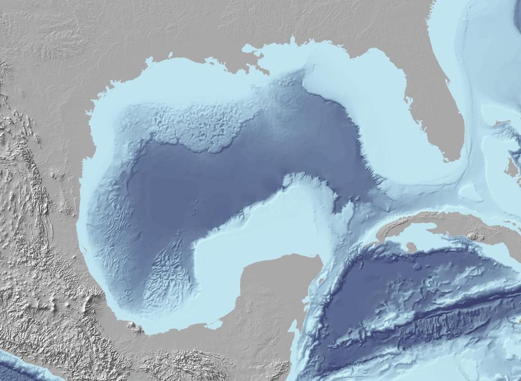
5 Bathymetry of the eastern GOM 700 mt 1800 mt 400 mt

6 Isolation Mechanism

7 Cuba - Florida Collision LATE CRETACOUS PALEOCENE PALEOCENE / EOCENE Slab separation Adapted from Hutson, Mann and Renne, 1998


8 Climax Drawdown Shoreline LAND
9 Isolation Effects Rapid evaporative drawdown of Gulf Isostatic + tectonic uplift created a land bridge across Florida, Cuba, the Bahamas and Yucatan Extensive slumping of clastic shelf edges and slopes Canyon incision across shelves and slopes Bypass and recycling of sediments into the central Gulf Karsting of exposed shallow and deep basin carbonates Salt deposition in barred basins (i.e. Veracruz Basin) Massive hydocarbon release from hydrates and breached reservoirs triggered P/E Thermal Maximum(?)


10 Wilcox section Union Oil Trident well (2001) feet Green zones = oil sands ~400 mts. >70% sand Blickwede et al., 2004
11 Whopper Sand in the Great White well Contemporaneous shelf break 400 mts. Note the sharp base and top = sudden, not gradational changes Berman and Rosenfeld, 2008

12 Wilcox Regional Cross Section AC 857 Great White #1 AC 859 Tobago AC 903 #1 Trident 1 AC 818 Tiger AC 951 Toledo 1 AC 557 BAHA 2 GR 13 mi. 5 mi. 7 mi. 10 mi. 27 mi. 0 KC 681 Sardinia 1 KC 919 Hadrian 1 WR 759 Jack 1 WR 678 St Malo 2 WR 724 Das Bump WR 469 Chinook WR 206 Cascade 0.1 Feet TVD MD mi. 57 mi. 39 mi. 7 mi. 22 mi. 33 mi. 16 mi. 32 mi. 58 mi. AT 63 Champlain #4 AT 336 Showboat 38 mi. 34 mi. 1 A Rains, Zarra & Meyer, B C 1 AT 182 Sturgis DRES 150 Top Wilcox 51.8 DLS (Wilcox 1a) 55.5 SB (Wilcox 1b) AT 574 Neptune #1 3 E 4 F G 57.5 Ma SB (Wilcox 2) 2 Announced Discovery H 58.5 Ma SB (Wilcox 3) Davy Jones Dry hole (non-commercial hydrocarbons encountered Well Log Cross Section 3 I 59.2 Ma SB (Wilcox 4) 0.8 my >1500 m/my Midway 60.0 SB Cretaceous 65.5 SB Whopper Sandstone Sturgis Showboat North Platte Tiber 4 Kaskida BAHA Tucker Sardinia Tobago Diamond Back 600 kms. end-to-end Champlain Great White Trident Tiger Toledo Hadrian St. Malo Jack Tonga Neptune Atlan tis Cascade Chinook Stones Das Bump
13 Deep Water Wilcox Sandstone Trend = Proven sandstone area Yoakum Hardin St. Landry Late Paleocene Shelf Margin Rio Grande Davy Jones Mexican Perdido Bejuco - La Laja Chicontepec Puskón Coatzacoalcos Grijalva - Usumacinta KMZ
14 "Forced Regression" Sequence 15 cm. Successive cannibalization of earlier fans by continual lowering of base level Posamentier et al, 1992
15 Paleocanyons Yoakum Paleocanyon Late Paleocene Shelf Margin Gulf of Mexico From Galloway, Dingus and Paige, 1991

16 Yoakum Paleocanyon ~ 100 kms long 1200 meters deep Cuts across shelf SHELF SHELF From Galloway, Dingus and Paige, 1991

17 Seismic Section Yoakum Paleocanyon P. Britt, HGS Bulletin April, 2006

18 Yoakum Paleocanyon Upper Wilcox Upper Wilcox Massive Sands Shelf Sands 3 Km m. Decompacted Shale fill Shale ~800 mt., Lower Wilcox Shelf Sands V.E. = ~3X From Hoyt, 1959

19 Central Mexico Paleocanyons Bejuco-La Laja Paleocanyon Chicontepec Paleocanyon Tuxpan Platform Youngest subcrop = Paleocene Oldest Fill = Eocene Nautla Paleocanyon Adapted from Pemex, 1999
20 Chicontepec Paleocanyon eroded into lithified carbonates Poza Rica Field Cretaceous subcrop Jurassic subcrop Adapted from Busch and Govela, 1978

21 Poza Rica 3D Seismic (Time slice) Sinkholes in Cretaceous deep water carbonates Horbury, 2004
22 Campo Poza Rica Faja de Oro SO NE 1500 mt. From Coogan, Bebout and Maggio, 1972 Adapted from Coogan, Bebout and Maggio, 1972

23 Cerro Azul # 4: February, ,858 bopd 24 degree API TD = 2,000 feet

24 Veracruz Basin-Oceanic Crust VCB From Bird et. al, 2005
 Mataespino 101-B well Veracruz Basin Bird et.")
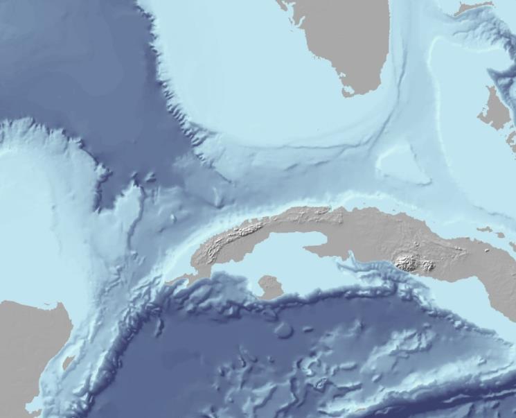
25 N Veracruz Basin separated from main GOM by a basaltic transform ridge (Anegada High) Mataespino 101-B well Veracruz Basin Bird et. al, 2005
26 Copied with permission of Pemex Pemex Mataespino-101B 0.0 GAMMA SONIC NEUTRON 's of meters of gray EOCENE shale 30 m. of red-brown saltbearing section (dip corrected) Core is in Veracruz
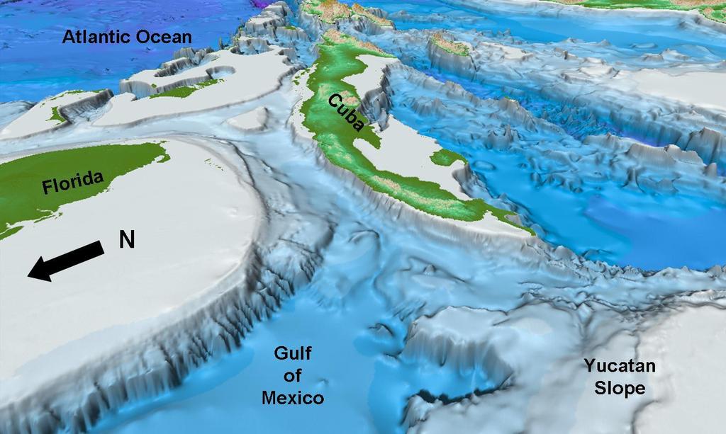
27 The Southeastern Gulf (Florida and Yucatan margins)

28

29 Erosional Aspect of the Florida and Yucatán Carbonate Escarpments Abyssal Plain >3,000 mts. below sea level Detailed Bathymetry FLORIDA CARBONATE PLATFORM Florida Canyon YUCATAN SLOPE NOTE: No Paleocene/Eocene tectonic activity, topographic relief, nor major rivers.

30 1803 Florida Canyon (depths in meters)

31 Typical minor canyon kms. 1 : 1 2,000 mt. 3,000 mt

32 A: Sinkholes on Florida Slope > 3300

33 Seismic Line Location SF-6B CUBA YUCATAN

34 Seismic Line SF-6B To Cuba 3,000 mt. water depth UK/T Water depth > 3,000 m. Basal Eocene Erosion Surface MCSB From Marton and Buffler, 1999


35 A B Chicxulub Crater

36 Area A Starved margin (no barrier reef) No nearby topographic relief No major surface drainage Lithified carbonate outcrops


37 3700 m 1100 m 900 m 20 km 135 m 730 m


38 Area A - detail = sink holes

")
39 Area B (NW Yucatan Margin)
40 Reconnection and Refill
41 Breakthrough and Refill


42 Thalweg >800 meters into lithified mid-cretaceous carbonates DSDP Leg 77, 1981 Straits of Florida Site 535
43 DSDP Leg 77, Site 535 (site is on the flank of the thalweg)

44 Sinkholes and Erosion in Deep Florida Strait Florida Slope Approx. area of Cuban 3D Bathymetry in meters Shown at Barcelona AAPG, 2005


45 S Sinkholes and Erosion in Florida Strait on 3D Seismic Water depth~ 2,000 mt. Sinkholes N Cretaceous Basinal Carbonates

46

 Bahamas")
47 Bahamas Channel Top Cretaceous (Bahamas Petroleum Company website) Bahamas Platform CUBA

48 SW Bahamas Channel Seismic NE Erosion surface From Bahamas Petroleum Company website
49 Conclusion: Anomalies that the drawdown explains and other hypotheses don t: Sudden inception and cessation of massive sheet sand deposition at least 450 kms outboard of the shelfbreak. Rapid excavation of deep canyons across tens of kms of shelf without tectonic uplift or global drop in sea level. Erosion of hard rock in the deep basin (karst and canyons). Deep thalweg in the Cuba - Florida/Bahamas suture zone.

50 Everyone s an Expert on the Gulf


51 Occam s Razor Rules! "Everything should be made as simple as possible, but not simpler. A. Einstein
Paleocene-Eocene Drawdown and Refill of the Gulf of Mexico*
 Paleocene-Eocene Drawdown and Refill of the Gulf of Mexico* Joshua Rosenfeld 1 Search and Discovery Article #30455 (2016)** Posted May 16, 2016 *Adapted from oral presentation given at AAPG Geosciences
Salt Geology and New Plays in Deep-Water Gulf of Mexico* By Abu Chowdhury 1 and Laura Borton 1
 Salt Geology and New Plays in Deep-Water Gulf of Mexico* By Abu Chowdhury 1 and Laura Borton 1 Search and Discovery Article #10131 (2007) Posted August 25, 2007 *Adapted from extended abstract prepared
THE NORPHLET SANDSTONE AND OTHER PETROLEUM PLAYS ALONG AND OUTBOARD OF THE FLORIDA ESCARPMENT, EASTERN GULF OF MEXICO
 THE NORPHLET SANDSTONE AND OTHER PETROLEUM PLAYS ALONG AND OUTBOARD OF THE FLORIDA ESCARPMENT, EASTERN GULF OF MEXICO Glyn Roberts 1, Joe Erickson 2 1 Consultant, Bedford, UK; 2 Spectrum, Houston, TX.
Prospective Resources as of January 1, 2008
 Prospective Resources as of January 1, 2008 3 Mexico s prospective resources and their distribution in the most important producing basins are listed in this chapter. Pemex Exploración y Producción has
EGAS. Ministry of Petroleum
 EGAS Ministry of Petroleum EGAS Ministry of Petroleum About The Block Location: N. El Arish offshore block is located in the extreme eastern part of the Egypt s economic water border and bounded from the
Controls on clastic systems in the Angoche basin, Mozambique: tectonics, contourites and petroleum systems
 P2-2-13 Controls on clastic systems in the Angoche basin, Mozambique: tectonics, contourites and petroleum systems Eva Hollebeek, Olivia Osicki, Duplo Kornpihl Schlumberger, London, UK Introduction Offshore
EGAS. Ministry of Petroleum
 EGAS Ministry of Petroleum EGAS Ministry of Petroleum About The Block Location: N. Thekah offshore block is located at about 56 km to the north of the Mediterranean shore line, 85 km to the north west
The Perdido and the Southwestern Gulf of Mexico
 Im Fifth Annual AAPG-SPE Deepwater Reservoirs, Geosciences Technology Workshop The Perdido and the Southwestern Gulf of Mexico Milena Colmenares, January, 2014 1 Exploration blocks PEMEX Perdido Fold Belt
A comparison of structural styles and prospectivity along the Atlantic margin from Senegal to Benin. Peter Conn*, Ian Deighton* & Dario Chisari*
 A comparison of structural styles and prospectivity along the Atlantic margin from Senegal to Benin Overview Peter Conn*, Ian Deighton* & Dario Chisari* * TGS, Millbank House, Surbiton, UK, KT6 6AP The
Reading Material. See class website. Sediments, from Oceanography M.G. Gross, Prentice-Hall
 Reading Material See class website Sediments, from Oceanography M.G. Gross, Prentice-Hall Materials filling ocean basins Dissolved chemicals especially from rivers and mid-ocean ridges (volcanic eruptions)
EXTENSION, SEDIMENTATION AND MODIFICATION OF THE GREATER GULF OF MEXICO BASIN
 EXTENSION, SEDIMENTATION AND MODIFICATION OF THE GREATER GULF OF MEXICO BASIN --AND THE PLACE OF THE EAST TEXAS BASIN WITHIN IT Thomas E. Ewing, Frontera Exploration Consultants, San Antonio TX tewing@fronteraexploration.com
The Late Tertiary Deep-Water Siliciclastic System of the Levant Margin - An Emerging Play Offshore Israel*
 The Late Tertiary Deep-Water Siliciclastic System of the Levant Margin - An Emerging Play Offshore Israel* Michael A. Gardosh 1, Yehezkel Druckman 2 and Binyamin Buchbinder 2 Search and Discovery Article
Kilometre-Scale Uplift of the Early Cretaceous Rift Section, Camamu Basin, Offshore North-East Brazil*
 Kilometre-Scale Uplift of the Early Cretaceous Rift Section, Camamu Basin, Offshore North-East Brazil* Iain Scotchman 1 and Dario Chiossi 2 Search and Discovery Article #50183 (2009) Posted May 20, 2009
In 1990, 50% of the U.S. population lived within 75 km of a coast. By 2010, 75% of the U.S. population will live within 75 km of a coast.
 In 1990, 50% of the U.S. population lived within 75 km of a coast. By 2010, 75% of the U.S. population will live within 75 km of a coast. High Tech Methods for Surveying the Deep Sea Floor Fig. 20.18 1
Case Study of the Structural and Depositional-Evolution Interpretation from Seismic Data*
 Case Study of the Structural and Depositional-Evolution Interpretation from Seismic Data* Yun Ling 1, Xiangyu Guo 1, Jixiang Lin 1, and Desheng Sun 1 Search and Discovery Article #20143 (2012) Posted April
Ministry of Oil and Minerals Petroleum Exploration & Production Authority BLOCK 85 (Al Uqlah North)
") Ministry of Oil and Minerals Petroleum Exploration & Production Authority BLOCK 85 (Al Uqlah North) The Al Uqlah North Block (85) occupies an area of 597 km 2 in the Sabatayn Basin in the province of Shabwah
Ministry of Oil and Minerals Petroleum Exploration & Production Authority BLOCK 85 (Al Uqlah North) The Al Uqlah North Block (85) occupies an area of 597 km 2 in the Sabatayn Basin in the province of Shabwah
Seismic Expressions of Submarine Channel - Levee Systems and Their Architectural Elements
 Seismic Expressions of Submarine Channel - Levee Systems and Their Architectural Elements Summary D.V. Ramana, Santanu De* and Kalyanbrata Datta KDMIPE, ONGC, Dehradun E-mail- devvenram@rediffmail.com
Earth s Continents and Seafloors. GEOL100 Physical Geology Ray Rector - Instructor
 Earth s Continents and Seafloors GEOL100 Physical Geology Ray Rector - Instructor OCEAN BASINS and CONTINENTAL PLATFORMS Key Concepts I. Earth s rocky surface covered by of two types of crust Dense, thin,
Blocks offered in Sri Lanka s Second Licensing Round
 Blocks offered in Sri Lanka s Second Licensing Round Sri Lankan Main Basins Cauvery Basin Cauvery Deep Water sub-basin Mannar Basin 2 Structural Framework Sri Lanka Basins Cauvery & Mannar Basins were
Downloaded 11/20/12 to Redistribution subject to SEG license or copyright; see Terms of Use at
 AVO crossplot analysis in unconsolidated sediments containing gas hydrate and free gas: Green Canyon 955, Gulf of Mexico Zijian Zhang* 1, Daniel R. McConnell 1, De-hua Han 2 1 Fugro GeoConsulting, Inc.,
Vail et al., 1977b. AAPG 1977 reprinted with permission of the AAPG whose permission is required for further use.
 Well 5 Well 4 Well 3 Well 2 Well 1 Vail et al., 1977b AAPG 1977 reprinted with permission of the AAPG whose permission is required for further use. Well 5 Well 4 Well 3 Well 2 Well 1 Vail et al., 1977b
Geologic Mapping Invitational Trial Event
 Geologic Mapping Invitational Trial Event A TEAM OF UP TO: 2 Team Name AVAILABLE TIME: 50 min Required Materials: Each team MUST have a protractor, ruler, non-programmable calculator, colored pencils,
GEOLOGY MEDIA SUITE Chapter 5
 UNDERSTANDING EARTH, SIXTH EDITION GROTZINGER JORDAN GEOLOGY MEDIA SUITE Chapter 5 Sedimentation Rocks Formed by Surface Processes 2010 W.H. Freeman and Company Mineralogy of sandstones Key Figure 5.12
The Ocean Floor Earth Science, 13e Chapter 13
 The Ocean Floor Earth Science, 13e Chapter 13 Stanley C. Hatfield Southwestern Illinois College The vast world ocean Earth is often referred to as the blue planet Seventy-one percent of Earth s surface
Maturity Modeling of Gomin and South Gomin fields Southern Pattani Basin, Gulf of Thailand
 Maturity Modeling of Gomin and South Gomin fields Southern Pattani Basin, Gulf of Thailand Patinya Jaithan Petroleum Geoscience Program, Department of Geology, Faculty of Science, Chulalongkorn University,
14.2 Ocean Floor Features Mapping the Ocean Floor
 14.2 Ocean Floor Features Mapping the Ocean Floor The ocean floor regions are the continental margins, the ocean basin floor, and the mid-ocean ridge. 14.2 Ocean Floor Features Continental Margins A continental
Horizontal Well Injector/Producer Pair Platong Field, Pattani Basin, Thailand*
 Horizontal Well Injector/Producer Pair Platong Field, Pattani Basin, Thailand* Abhiphat Pakdeesirote 1, Sonchawan Ackagosol 3, Sarayoot Geena 3, Nualjun Kitvarayut 3, Kenneth Lewis 2, Tom Tran 3, Nancy
Sequence Stratigraphic Analysis of Mixed, Reefal Carbonate and Siliciclastic Systems. Ashton Embry. Geological Survey of Canada.
 Sequence Stratigraphic Analysis of Mixed, Reefal Carbonate and Siliciclastic Systems Ashton Embry Geological Survey of Canada Outline Sequence Stratigraphy Sequence Surfaces and Sequence Boundaries for
Salt tectonic styles in the spreading basin: Yucatan, Offshore Mexico Purnima Bhowmik*, Rodolfo Hernandez and Katarina Rothe, TGS
 1 Purnima Bhowmik*, Rodolfo Hernandez and Katarina Rothe, TGS Summary The TGS Gigante project is comprised of 188,497 km of 2D seismic data acquired in 2016 and primarily covering the offshore Mexican
Education Days Moscow Closing Session
 Education Days Moscow 2013 Basin and Petroleum Systems Modelling: Applications for Conventional and Unconventional Petroleum Exploration Risk and Resource Assessments By Dr Bjorn Wygrala Schlumberger 21-22
RELINQUISHMENT REPORT. License P1546 Block April 2009
 RELINQUISHMENT REPORT License P1546 Block 110-01 14 April 2009 Sherritt International Oil and Gas Limited 2000, 425-1 st street S.W., Calgary, Alberta Canada T2P 3L8 Telephone (403) 260-2900 Fax (403)
II CENTRAL & NORTH ATLANTIC CONJUGATE MARGINS CONFERENCE
 http://metododirecto.pt/cm2010 IB: 978-989-96923-1-2 Volume VI p. 167-171 II CETRAL & ORTH ATLATIC COJUGATE MARGI COFERECE Hydrocarbon Prospectivity of a ew Deepwater Petroleum Province, Offshore enegal
MARINE GEOLOGY & GEOGRAPHY
 MARINE GEOLOGY & GEOGRAPHY Bathymetry BATHYMETRY BATHYMETRY THE UNDERWATER EQUIVALENT TO TOPOGRAPHY THE STUDY OF WATER DEPTH A BATHYMETRIC MAP SHOWS FLOOR RELIEF OR TERRAIN AS CONTOUR LINES Bathymetry
Meandering Miocene Deep Sea Channel Systems Offshore Congo, West Africa
 Meandering Miocene Deep Sea Channel Systems Offshore Congo, West Africa S. Baer* (PGS), J. E. Comstock (PGS), K. Vrålstad (PGS), R. Borsato (PGS), M. Martin (PGS), J.P. Saba (SNPC), B. Débi-Obambé (SNPC)
Offshore Neogene Plays, Salina del Istmo Basin, Southeast of Mexico
 Offshore Neogene Plays, Salina del Istmo Basin, Southeast of Mexico ROBLES-NOLASCO, J.; PLIEGO-VIDAL, E.; TOLEDO-BANTE, C.; PIMIENTA-LUGO, M.; ORTEGA-GONZALEZ, V.; MARTINEZ-PEÑA, B. and HEREDIA-CERVANTES,
Ministry of Oil and Minerals Petroleum Exploration & Production Authority BLOCK 6 (Iryam)
") Ministry of Oil and Minerals Petroleum Exploration & Production Authority BLOCK 6 (Iryam) The Iryam Block (6) occupies an area of 3,911 km 2 in the Sabatayn Basin in the province of Shabwah in central
Ministry of Oil and Minerals Petroleum Exploration & Production Authority BLOCK 6 (Iryam) The Iryam Block (6) occupies an area of 3,911 km 2 in the Sabatayn Basin in the province of Shabwah in central
REGIONAL GEOLOGY IN KHMER BASIN
 CONTENTS 1-Khmere Basin 2-Regional Geology Khmer Basin 3-Regime Tectonic 4-Seismic Database -a/ Acquisition Data -b/ Prospect Angkor -C/ Cross Section Seismic 5-Play Type -a/ Play Schematic -b/ Structure
Geologic Mapping Regional Tournament Trial Event
 Geologic Mapping Regional Tournament Trial Event A TEAM OF UP TO: 2 Team Name AVAILABLE TIME: 50 min Required Materials: Each team MUST have a protractor, ruler, non-programmable calculator, colored pencils,
Figure 1 Extensional and Transform Fault Interaction, Influence on the Upper Cretaceous Hydrocarbon System, Equatorial Margin, West Africa.
 Figure 1 Extensional and Transform Fault Interaction, Influence on the Upper Cretaceous Hydrocarbon System, Equatorial Margin, West Africa. Presented to the 10th PESGB/HGS Conference on Africa E + P September
MULTIPLE CHOICE. Choose the one alternative that best completes the statement or answers the question.
 Geology 300, Physical Geology Spring 2019 Quiz Chapter 18, Seafloor Name MULTIPLE CHOICE. Choose the one alternative that best completes the statement or answers the question. 1) Abyssal fans are made
Clint Moore with Bill Lefler, Tom Uphoff, Rich Heaney, & Mike Neese
 The Evolution of a Proven Giant Oil & Gas Play in Subsalt Miocene Lower Slope Sands-Reservoirs of the Federal Offshore OCS Shelf, US Gulf of Mexico Clint Moore with Bill Lefler, Tom Uphoff, Rich Heaney,
Figure 1: Location and bathymetry of the study area. Gulf of Guinea. Cameroon. Congo. Gabon. PGS/DGH Gabon MegaSurvey Coverage (35000Km 2 ) Eq.
 Eq.") Deepwater hydrocarbon prospectivity analysis of offshore North and South Gabon Muhammad S Tamannai (*), Thomas Hansen (1), Ron Borsato (1), Jennifer Greenhalgh (1) Martial-Rufin Moussavou (2) & Landry
Deepwater hydrocarbon prospectivity analysis of offshore North and South Gabon Muhammad S Tamannai (*), Thomas Hansen (1), Ron Borsato (1), Jennifer Greenhalgh (1) Martial-Rufin Moussavou (2) & Landry
Effects of Tides on Deltaic Deposition: Causes and Responses*
 Effects of Tides on Deltaic Deposition: Causes and Responses* Piret Plink-Bjorklund 1 Search and Discovery Article #50626 (2012)** Posted June 25, 2012 *Adapted from oral presentation at AAPG Annual Convention
Last Time. Submarine Canyons and Fans. Turbidites. MAS 603: Geological Oceanography. Lecture 16: Greenhouse vs. Icehouse Earths
 UNIVERSITY OF SOUTH ALABAMA Last Time MAS 603: Geological Oceanography Lecture 16: Greenhouse vs. Icehouse Earths Submarine Fans Definition and morphology Transport mechanisms (density currents) Submarine
Marine Science and Oceanography
 Marine Science and Oceanography Marine geology- study of the ocean floor Physical oceanography- study of waves, currents, and tides Marine biology study of nature and distribution of marine organisms Chemical
RELINQUISHMENT REPORT FOR LICENCE P.1663, BLOCK 29/4b and 29/5e
 RELINQUISHMENT REPORT FOR LICENCE P.1663, BLOCK 29/4b and 29/5e Licence: P.1663 Blocks: 29/4b & 29/5e 25th Round Traditional Licence Operator: Ithaca Energy UK(Ltd) 100% Work Programme Summary The agreed
Foundations of Earth Science, 6e Lutgens, Tarbuck, & Tasa
 Foundations of Earth Science, 6e Lutgens, Tarbuck, & Tasa Oceans: The Last Frontier Foundations, 6e - Chapter 9 Stan Hatfield Southwestern Illinois College The vast world ocean Earth is often referred
Exploration, Drilling & Production
 Nontechnical Guide to PETMOLEUM Geology, Exploration, Drilling & Production Third Edition Norman J. Hyne, Ph.D. Contents Preface *i Introduction 1 The Nature of Gas and Oil 1 Petroleum 1 The Chemistry
The Marine Environment
 The Marine Environment SECTION 16.1 Shoreline Features In your textbook, read about erosional landforms, beaches, estuaries, longshore currents, and rip currents. For each statement below, write or. 1.
OCN 201 Physiography of the Seafloor
 OCN 201 Physiography of the Seafloor Hypsometric Curve for Earth s solid surface Note histogram Hypsometric curve of Earth shows two modes. Hypsometric curve of Venus shows only one! Why? Ocean Depth vs.
Continental Landscapes
 Continental Landscapes Landscape influenced by tectonics, climate & differential weathering Most landforms developed within the last 2 million years System moves toward an equilibrium Continental Landscapes
The Marine Environment
 The Marine Environment SECTION 16.1 Shoreline Features In your textbook, read about erosional landforms, beaches, estuaries, longshore currents, and rip currents. For each statement below, write true or
NORTHEAST RAMADAN BLOCK
 LOCATION : The block lies in the eastern side of the central part of the Gulf of Suez basin north and south of BP Ramadan, SB and Morgan fields. 2D &3D SEISMIC COVERAGE AREA : 219 km 2 WELLS : 5 Wells
Orphan Basin, Offshore Newfoundland: New seismic data and hydrocarbon plays for a dormant Frontier Basin
 Orphan Basin, Offshore Newfoundland: New seismic data and hydrocarbon plays for a dormant Frontier Basin Jerry Smee* G&G Exploration Consulting, 301 400-3rd Avenue SW, Calgary, AB, T2P 4H2 Sam Nader, Paul
Structural Geology of the Mountains
 Structural Geology of the Mountains Clinton R. Tippett Shell Canada Limited, Calgary, Alberta clinton.tippett@shell.ca INTRODUCTION The Southern Rocky Mountains of Canada (Figure 1) are made up of several
Investigation of Devonian Unconformity Surface Using Legacy Seismic Profiles, NE Alberta
 Investigation of Devonian Unconformity Surface Using Legacy Seismic Profiles, NE Alberta Elahe P. Ardakani and Douglas R. Schmitt Department of Physics, University of Alberta Summary The Devonian Grosmont
Biostratigraphic and Lithostratigraphic Correlation of Sedimentary Strata in the Atlantic Coastal Plain
 Biostratigraphic and Lithostratigraphic Correlation of Sedimentary Strata in the Atlantic Coastal Plain Introduction to the Atlantic Coastal Plain (Please read this page prior to doing the lab) The Atlantic
Search and Discovery Article #40536 (2010) Posted June 21, 2010
 Posted June 21, 2010") Modern Examples of Mass Transport Complexes, Debrite and Turbidite Associations: Geometry, Stratigraphic Relationships and Implications for Hydrocarbon Trap Development* Fabiano Gamberi 1, Marzia Rovere
Modern Examples of Mass Transport Complexes, Debrite and Turbidite Associations: Geometry, Stratigraphic Relationships and Implications for Hydrocarbon Trap Development* Fabiano Gamberi 1, Marzia Rovere
Bulletin of Earth Sciences of Thailand
 Quantitative Seismic Geomorphology of Early Miocene to Pleistocene Fluvial System of Northern Songkhla Basin, Gulf of Thailand Oanh Thi Tran Petroleum Geoscience Program, Department of Geology, Faculty
UNIT 3 GEOLOGY VOCABULARY FLASHCARDS THESE KEY VOCABULARY WORDS AND PHRASES APPEAR ON THE UNIT 3 CBA
 UNIT 3 GEOLOGY VOCABULARY FLASHCARDS THESE KEY VOCABULARY WORDS AND PHRASES APPEAR ON THE UNIT 3 CBA A map that shows Earth s Topographic Map surface topography, which is Earth s shape and features Contour
Gulf of México Mapping NATCARB Atlas
 Gulf of México Mapping NATCARB Atlas Presenter: Ramón Treviño Gulf Coast Carbon Center University of Texas at Austin, Bureau of Economic Geology NACAP Cuernavaca, Morelos, México March 9, 2010 Acknowledgements
Small area of the ocean that is partially surrounded by land. The Ocean Basins. Three Major Oceans. Three Major Oceans. What is a SEA?
 The Ocean Basins How Deep is the Ocean? 1 2 Three Major Oceans Three Major Oceans Pacific Atlantic the shallowest ocean (3.3km average depth) Indian second shallowest ocean (3.8km average depth) Pacific
Prospective Resources as of January 1, 2009
 Hydrocarbon Reserves of Mexico Prospective Resources as of January 1, 2009 3 Mexico s prospective resources and their distribution in the most important producing basins are listed in this chapter. Petróleos
Geoscience 001 Fall Rock Identification and Contextual Interpretation
 Geoscience 00 Fall 2005 Rock Identification and Contextual Interpretation The purpose of this week s lab is to gain some more experience and practice in identifying rocks and then interpreting the geologic
Laboratory Exercise #4 Geologic Surface Processes in Dry Lands
 Page - 1 Laboratory Exercise #4 Geologic Surface Processes in Dry Lands Section A Overview of Lands with Dry Climates The definition of a dry climate is tied to an understanding of the hydrologic cycle
Petroleum Prospectivity in the Namibe and Southern Benguela Basins, Offshore Angola
 Petroleum Prospectivity in the Namibe and Southern Benguela Basins, Offshore Angola C. Koch* (PGS), F. Pepe (PGS), R. Vasconcelos (PGS), F. Mathew (PGS), R. Borsato (PGS) & M.P.C. de Sá (Sonangol) SUMMARY
MUHAMMAD S TAMANNAI, DOUGLAS WINSTONE, IAN DEIGHTON & PETER CONN, TGS Nopec Geological Products and Services, London, United Kingdom
 Geological and Geophysical Evaluation of Offshore Morondava Frontier Basin based on Satellite Gravity, Well and regional 2D Seismic Data Interpretation MUHAMMAD S TAMANNAI, DOUGLAS WINSTONE, IAN DEIGHTON
Ocean Basins, Bathymetry and Sea Levels
 Ocean Basins, Bathymetry and Sea Levels Chapter 4 Please read chapter 5: sediments for next class and start chapter 6 on seawater for Thursday Basic concepts in Chapter 4 Bathymetry the measurement of
Distribution of Overpressure and its Prediction in Saurashtra Dahanu Block, Western Offshore Basin, India*
 Distribution of Overpressure and its Prediction in Saurashtra Dahanu Block, Western Offshore Basin, India* Kanak R. Nambiar 1, B.K. Singh 2, R.N. Goswami 2, and K.R.K. Singh 2 Search and Discovery Article
Chapter 5. The Sedimentary Archives
 Chapter 5 The Sedimentary Archives Factors affecting Sedimentary Characteristics 1. Tectonic setting 2. Physical, chemical, and biological processes in the depositional environment 3. Method of sediment
Chapter 9 Lecture Outline. Oceans: The Last Frontier
 Chapter 9 Lecture Outline Oceans: The Last Frontier The Vast World Ocean Earth is referred to as the blue planet 71% of Earth s surface is oceans and marginal seas Continents and islands comprise the remaining
APPENDIX C GEOLOGICAL CHANCE OF SUCCESS RYDER SCOTT COMPANY PETROLEUM CONSULTANTS
 APPENDIX C GEOLOGICAL CHANCE OF SUCCESS Page 2 The Geological Chance of Success is intended to evaluate the probability that a functioning petroleum system is in place for each prospective reservoir. The
BALOCHISTAN FOLDBELT BASIN
 INTRODUCTION BALOCHISTAN FOLDBELT BASIN The Kharan-3 block is located in the Kharan Trough of Balochistan Basin. GEOLOGICAL SETTING The Balochistan Province is an Upper Cretaceous to Recent structurally
Play fairway mapping in the Northeast Atlantic Margin Comparison between mature and immature basins. David Mudge, Joanne Cranswick
 Play fairway mapping in the Northeast Atlantic Margin Comparison between mature and immature basins David Mudge, Joanne Cranswick Contents Ternan North Sea Play fairway mapping Tertiary case study Northeast
Downloaded 09/29/16 to Redistribution subject to SEG license or copyright; see Terms of Use at
 Richard Wright*, James Carter, Ian Atkinson, Erin Gillis, Deric Cameron, and Leona Stead, Nalcor Energy Tom Neugebauer, TGS Jerry Witney, PGS Daniel Hughes and Michael Hall, Airbus Defence and Space Summary
Neogene Uplift of The Barents Sea
 Neogene Uplift of The Barents Sea W. Fjeldskaar A. Amantov Tectonor/UiS, Stavanger, Norway FORCE seminar April 4, 2013 The project (2010-2012) Funding companies Flat Objective The objective of the work
Geologic Trips San Francisco and the Bay Area
 Excerpt from Geologic Trips San Francisco and the Bay Area by Ted Konigsmark ISBN 0-9661316-4-9 GeoPress All rights reserved. No part of this book may be reproduced without written permission in writing,
The Mesozoic. Wednesday, November 30, 11
 The Mesozoic Periods of the Mesozoic Triassic- First period of the Mesozoic era Jurassic Cretaceous- Last period of the Mesozoic era Breakup of Pangaea Stage one (Triassic) Rifting and volcanism, normal
NORTHEAST EL HAMD BLOCK
 NORTHEAST EL HAMD BLOCK NORTHEAST EL HAMD BLOCK LOCATION : The block is locating in the eastern side of the central part of the Gulf of Suez basin west and south of Belayim fields. NORTHEAST EL HAMD BLOCK
Vertical Hydrocarbon Migration at the Nigerian Continental Slope: Applications of Seismic Mapping Techniques.
 ROAR HEGGLAND, Statoil ASA, N-4035 Stavanger, Norway Vertical Hydrocarbon Migration at the Nigerian Continental Slope: Applications of Seismic Mapping Techniques. Summary By the use of 3D seismic data,
CLASTICS FIELD TRIP. Dynamic stratigraphy, facies, architecture and fracture analysis of coastal depositional systems
 CLASTICS FIELD TRIP Dynamic stratigraphy, facies, architecture and fracture analysis of coastal depositional systems MAY 2-5 SEPTEMBER 17-20, 2018 Appraisal and development of clastic reservoirs rely on
Perspectives from Offshore Argentina & Uruguay
 Perspectives from Offshore Argentina & Uruguay A Prospectivity Overview Hannah Kearns October 2018 Introduction Argentina Offshore License Round 1 14 blocks Argentina North, 24 Austral-Malvinas Offshore
Education Days Moscow Opening Session
 Education Days Moscow 2013 Basin and Petroleum Systems Modelling: Applications for Conventional and Unconventional Petroleum Exploration Risk and Resource Assessments By Dr Bjorn Wygrala Schlumberger 21-22
Module 10: Resources and Virginia Geology Topic 4 Content: Virginia Geology Notes
 Virginia is composed of a very diverse landscape that extends from the beaches and barrier islands all of the way to the highly elevated Appalachian Plateau. Geologists have discovered ancient shallow
Plate Tectonics 3. Where Does All the Extra Crust Go?
 Plate Tectonics 3 Where Does All the Extra Crust Go? Unless otherwise noted the artwork and photographs in this slide show are original and by Burt Carter. Permission is granted to use them for non-commercial,
Seismic stratigraphy, some examples from Indian Ocean, interpretation of reflection data in interactive mode
 Seismic stratigraphy, some examples from Indian Ocean, interpretation of reflection data in interactive mode K. S. Krishna National Institute of Oceanography, Dona Paula, Goa-403 004. krishna@nio.org Seismic
Unit 6: The Sea Floor
 Unit 6: The Sea Floor Turn to Page 62 in Introduction to the World s Oceans Study the bathymetric chart What features do you see? How do the Atlantic and Pacific Oceans differ? What do you think accounts
Ocean Floor. Continental Margins. Divided into 3 major regions. Continental Margins. Ocean Basins. Mid-Ocean Ridges. Include:
 Ocean Floor Divided into 3 major regions Continental Margins Ocean Basins Mid-Ocean Ridges Continental Margins Include: Continental Shelves Continental Slopes Continental Rise 1 Continental Shelves Part
Overview of Selected Shale Plays in New Mexico*
 Overview of Selected Shale Plays in New Mexico* Ron Broadhead 1 Search and Discovery Article #10627 (2014)** Posted August 18, 2014 *Adapted from presentation at RMAG luncheon meeting, Denver, Colorado,
OCN 201 Physiography of the Seafloor
 OCN 201 Physiography of the Seafloor 1 Ocean Depth versus Continental Height Why do we have dry land? Solid surface of Earth is dominated by two levels: Land with a mean elevation of +840 m (29% of Earth
B.C. s Offshore Oil and Gas: a Guide to the Geology and Resources.
 B.C. s Offshore Oil and Gas: a Guide to the Geology and Resources. Introduction Beneath the offshore regions of British Columbia are four moderately large, geologically young sedimentary basins (Figure
Oceanography is the scientific study of oceans Oceans make up over 70% of the Earth s surface
 Oceanography Oceanography is the scientific study of oceans Oceans make up over 70% of the Earth s surface An ocean must be large and have features which set it apart from other oceans (currents, water
Quiz 12 Bonus 2 (9:30-9:35 AM)
") Quiz 12 Bonus 2 (9:30-9:35 AM) UNIVERSITY OF SOUTH ALABAMA GY 112: Earth History Lectures 32 and 33: Mesozoic Sedimentation Instructor: Dr. Douglas W. Haywick Last Time Mesozoic Tectonics A) The Triassic
Quiz 12 Bonus 2 (9:30-9:35 AM) UNIVERSITY OF SOUTH ALABAMA GY 112: Earth History Lectures 32 and 33: Mesozoic Sedimentation Instructor: Dr. Douglas W. Haywick Last Time Mesozoic Tectonics A) The Triassic
Paleogene low stand deepwater canyon fill deposits in Mahanadi Offshore Basin: can it prove to be the elusive major hydrocarbon discovery?
 P-317 Paleogene low stand deepwater canyon fill deposits in Mahanadi Offshore Basin: can it prove to be the elusive major Summary *Pradipta Kumar Das & Sudipto Datta, ONGC Mahanadi Deepwater Offshore Basin
35th Annual GCSSEPM Foundation Bob F Perkins Research Conference 2016
 35th Annual GCSSEPM Foundation Bob F Perkins Research Conference 2016 Mesozoic of the Gulf Rim and Beyond: New Progress in Science and Exploration of the Gulf of Mexico Basin Houston, Texas, USA 8 9 December
Seismic interpretation of carbonate turbidites in Central Luconia
 GeoL. Soc. MaLayaia, BuLLetin 47, December 2005; pp. 77-85 Seismic interpretation of carbonate turbidites in Central Luconia FRANcis Ho, GUENTER JAEGER AND PmT LAMBREGTS Sarawak Shell Berhad SMEP Exploration
Licence P1368: Relinquishment Report (end of 2 nd term) Hurricane Exploration PLC
 Hurricane Exploration PLC") Licence P1368: Relinquishment Report (end of 2 nd term) Hurricane Exploration PLC March 2012 1. Header Licence Number: P1368 Licence Round: 23 rd Licence Type: Frontier Block Numbers: 202/4, 202/5, 204/30,
Licence P1368: Relinquishment Report (end of 2 nd term) Hurricane Exploration PLC March 2012 1. Header Licence Number: P1368 Licence Round: 23 rd Licence Type: Frontier Block Numbers: 202/4, 202/5, 204/30,
East Africa Transform Margin The View from Tanzania and Madagascar
 East Africa Transform Margin The View from Tanzania and Madagascar Richard Higgins and Mark Sofield 10 th PESGB/HGS Conference on African E & P, London, September 7-8, 2011 Acknowledgements Legal Notice:
Finding Oil by Utilizing Play Analysis
 Finding Oil by Utilizing Play Analysis Gulf of Mexico Outer Continental Shelf An Overview of the Plio-Pleistocene and Miocene Shelf Trends Chris Williams, PG. Geoscientist Gulf of Mexico Outer Continental
Map shows 3 main features of ocean floor
 Map shows 3 main features of ocean floor 2017 Pearson Education, Inc. Chapter 3 Marine Provinces 2017 Pearson Education, Inc. 1 Chapter 3 Overview The study of bathymetry determines ocean depths and ocean