The combination of factors required for the accumulation of sulphides occurs in three distinct environments (Pons and van Breemen 1982):
|
|
|
- Edmund Dawson
- 5 years ago
- Views:
Transcription
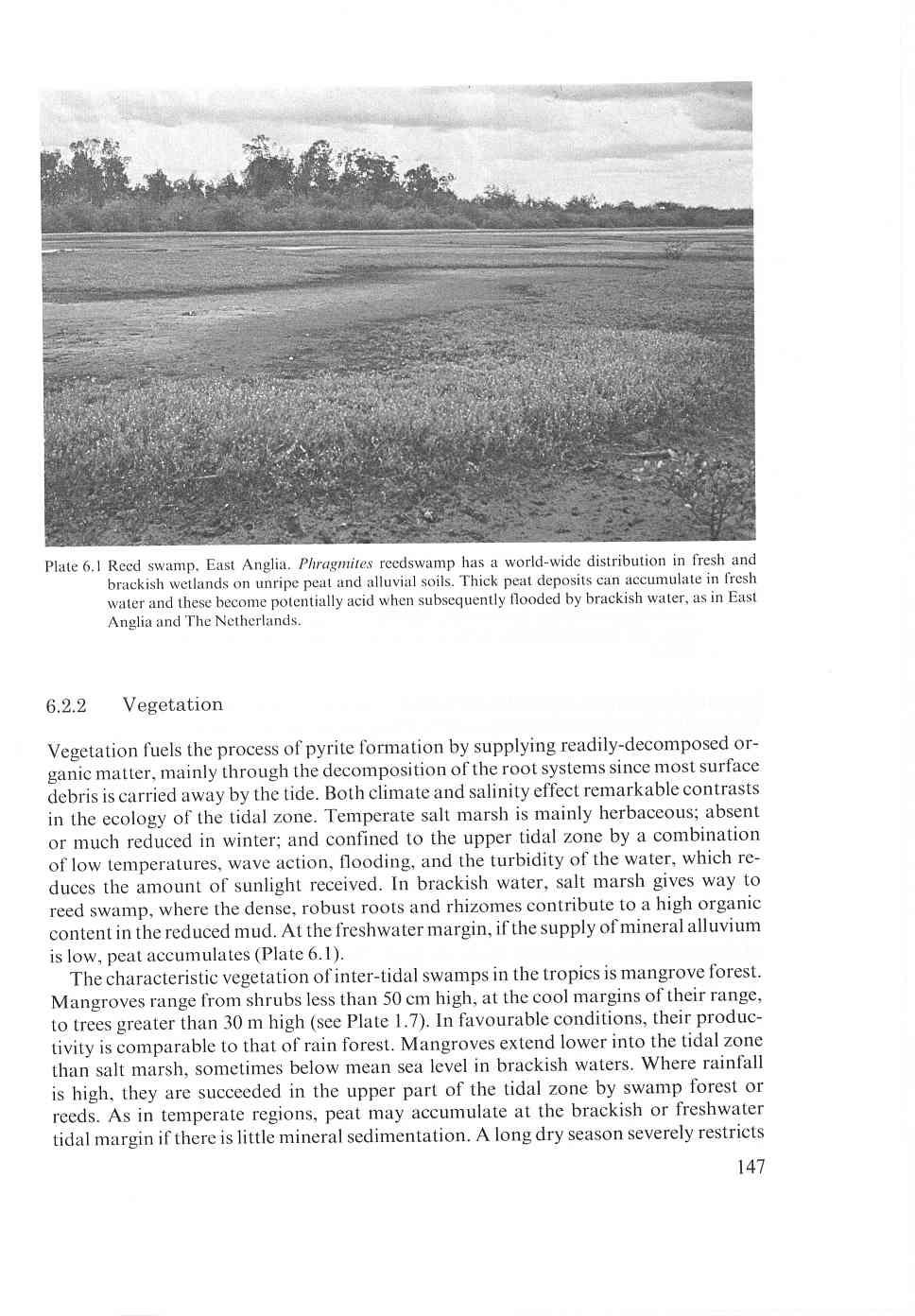
1 6 Soil patterns 6.1 Potential acid sulphate environments Soil variation is always a problem for land-use planning and management. Acid sulphate soils are notoriously localised. Even within a single area of acid sulphate soil, the severity of acidity, or potential acidity, can vary significantly from point to point. Relationships between soil characteristics and other facets of the landscape operate from the largest scale to the smallest. In this section, some generalisations are developed to help in identifying those parts of the landscape where acid sulphate soils can be expected. Because the detailed soil pattern of each area will be unique, this section can only give samples of the local links between acid sulphate soils and landforms, climate, ecology, and management. The combination of factors required for the accumulation of sulphides occurs in three distinct environments (Pons and van Breemen 1982): - Marshy inland valleys and basinsflushed by sulphate-rich waters draining from older sulphidic sediments. These are not extensive, but there are several local examples including sulphidic peats in Uganda (Chenery 1954) and Leningrad (Krym 1982), and sulphidic sands in The Netherlands (Poelman 1973); - Bottoms of saline and brackish seas and lakes. Organic-rich sediments deposited in saline or brackish water may accumulate significant concentrations of reduced sulphur, both as Fe (11) monosulphide and pyrite. The Littorina bottom sediments of the Baltic contain up to 2 per cent reduced sulphur. Isostatic recovery of the land, following glaciation, has brought some of these sediments above sea level, leading to the development of acid sulphate soils in coastal areas of Sweden and Finland (Wicklander et al. 1950; Kivinen 1950); - Saline and brackish water tidal swamp and marsh, which includes tidal flats, salt marsh, and mangrove swamp. This is the principal potential acid sulphate environment. 6.2 Soil patterns in the tidal zone Landforms Sulphidic soils develop most extensively where clayey sediment accretes slowly in saline and brackish water and, simultaneously, copious organic matter is supplied by swamp vegetation. The longer the duration of saline or brackish swamp conditions, and the greater the input of organic matter, the greater the accumulation of pyrite. Shelter from strong currents and wave action is conducive to the accumulation of mud and to its colonisation by vegetation. Favourable conditions occur in deltas, sheltered estuaries, coastlines protected by offshore islands and bars, and even open shores where wave energy is dissipated across a broad, gently-sloping coastal shelf. 145
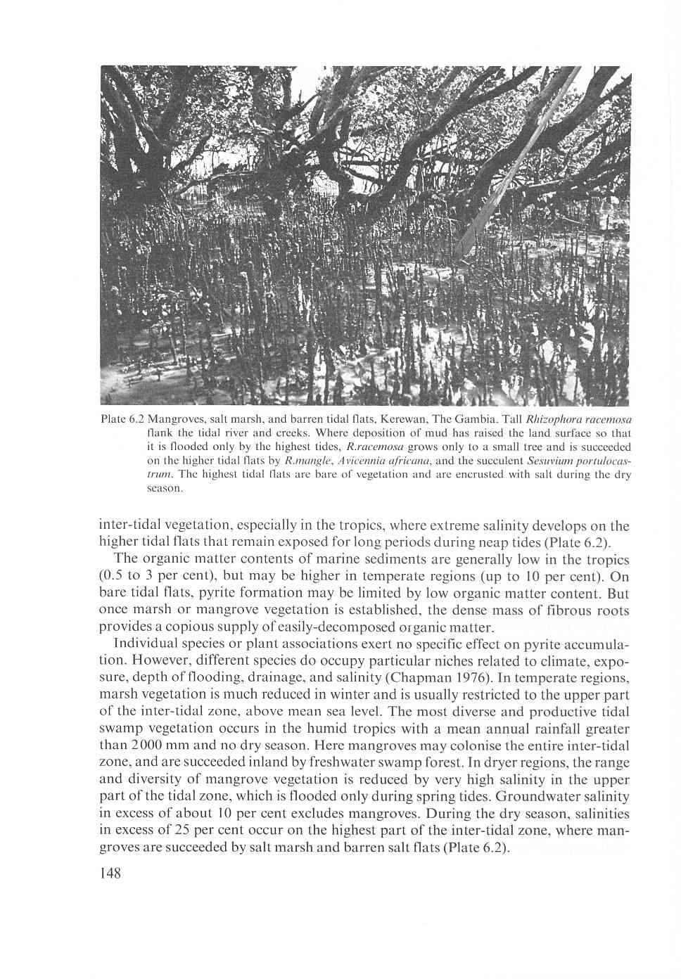
2 The lowest parts of the inter-tidal zone are flooded most of the time, so these soils are permanently reduced. In the higher parts of the tidal landscape, the upper horizons of the soil are predominantly oxidised. The tidal range, and the effectiveness of drainage, determine the thickness of oxidised, non-sulphidic material that will accrete above the permanently reduced, sulphidic substratum. The greater the tidal range, the broader the tidal zone, and the thicker the ultimate development of the oxidised surface horizon. Several hundreds of years seem to be needed for pyrite to accumulate in excess of the neutralising capacity of the soil. Therefore, potentially acid soils are likely to develop only in relatively stable systems, where sediment is accumulating slowly. Rapidly-accreting systems, or systems subject to alternate erosion and deposition, will not accumulate high concentrations of pyrite. Sandy sediments generally occur in less stable tidal environments. They rarely contain large amounts of pyrite, but only a small proportion of pyrite will produce severe acidity in a quartz sand, because there is little neutralising capacity. Striking differences in chemistry between soils of a relatively straight mudflat coast and an estuarine area dissected by tidal creeks are reported by Diemont and van Wijngaarden (1974), working in West Malaysia. In the reduced horizon of the straight coast, field ph values varied between 8 and 8.4, reflecting high concentrations of HCO; (10-26 mol m-3) in the interstitial water, and pyrite S contents were less than 0.5 per cent. In contrast, in the estuarine swamps, ph values of the reduced horizon were between 6.2 and 6.8, interstitial water was lower in dissolved HCO; (2-10 mol m-3), organic matter contents were higher, and pyrite S contents were between 1 and 2.5 per cent. Concentrations of dissolved sulphide were similar in the two environments, except during spring tides when they were reduced to undetectable levels in the estuarine soils. Pons and van Breemen (1982) attribute the apparent removal of dissolved sulphide and bicarbonate, and the increased accumulation of pyrite, to more effective tidal flushing. Flushing will be enhanced by the network of tidal creeks, and by greater soil permeability associated with a higher content of organic matter. Tidal flushing should promote pyrite formation, by removing HCO,, supplying the limited amount of dissolved oxygen necessary to form pyrite from reduced sulphide, and by accelerating rate-limiting processes that are otherwise dependent on diffusion. The different pyrite contents found along the Malaysian coast may equally be explained by the differing stability of the coastline. The straight coast is subject to strong tidal currents, and appears to be continually eroding and rebuilding. The rate of sedimentation, and the age and stability of the landscape determine the time available for the accumulation of pyrite. Where the rate of sedimentation is slow, and conditions for pyrite accumulation have persisted over a long period, very high reduced sulphur contents may occur (up to 25 kg S m-3 under Avicennia mangrove in northern New Zealand; up to 50 kg S m-3 under Rhizophora mangrove in The Gambia). Rapid sedimentation and a rapidly-aggrading coastline result in a much shorter period of favourable conditions for pyrite accumulation and, consequently, in sediments of low sulphur content. 146
3
4
5 .... I.. In a particular locality, the different swamp and marsh species indicate current differences in microtopography, hydrology, or salinity, which can be significant in land reclamation or management, but are not necessarily related to the pyrite content of the underlying soil, which may have developed under somewhat different conditions. In general, the largest areas of high pyrite content (more than 30 kg S m-3) are formed under big mangroves and Nypa, or other brackish water plant communities, succeeding mangrove. Very high pyrite contents also occur in peat soils that have been subject to a long period of brackish water flooding Changing sedimentary environments The relationship between post-glacial sea levels, the rate of sedimentation, and the regional distribution of acid sulphate soils was introduced in Section 1.3. During the last glacial period, the world sea level stood some 80 m below its present level. From about 18 or 19 O00 years ago, the sea level rose rapidly, reaching about'5 m below the present level about 7 O00 years ago. During the last 7 O00 years, the sea level has risen more slowly with cyclical fluctuations of about I m amplitude (Morner 1971; Tooley 1976; Blackwelder et al. 1979). Against this background of a eustatic rise in sea level, many areas have been subject to isostatic or tectonic uplift or subsidence, resulting in a variety of regional trends of relative sea level (see Figure 1.1). In each sedimentary basin, the combined effects of sea level changes and rates of sedimentation have affected the sedimentary environment, and also the time available for pyrite accumulation. Where sedimentation keeps pace with a rising sea level, a broad, stationary zone of tidal swamp or marsh vegetation may develop; tidal flushing remains active, and thick layers of sulphidic material can accumulate. Even under a stable sea level, strongly sulphidic sediments may accumulate if the rate of sedimentation is slow - so that favourable conditions for pyrite accumulation persist over a long period. Under the influence of a falling sea level, or very rapid sedimentation, accumulation of pyrite may be limited by the shorter period of suitable environment. Regional and local changes in sea level, sedimentation, hydrology, or water chemistry can result in the burial of sulphidic material by non-sulphidic alluvium or peat, so that potential acid sulphate soils may be found in freshwater or dryland environments, or pyrite may accumulate in peat or alluvium originally laid down in fresh water. 6.3 Regional soil patterns Contrasting regional patterns in South East Asia, resulting from different rates of sedimentation and rising sea level, were described briefly in Section Figure 6.1 shows the general soil pattern of the Chao Phraya Delta in Thailand. Here the sulphidic older marine clays, laid down in a broad, stationary tidal zone under a rapidly-rising sea level, are succeeded, about 40 km from the present coastline, by younger marine clays, laid down along a rapidly-advancing coastline. The younger clays are mostly not potentially acid. Inland, some of the older sulphidic clays are covered by a blanket of non-sulphidic 149

6
7
8
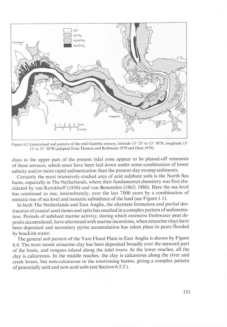
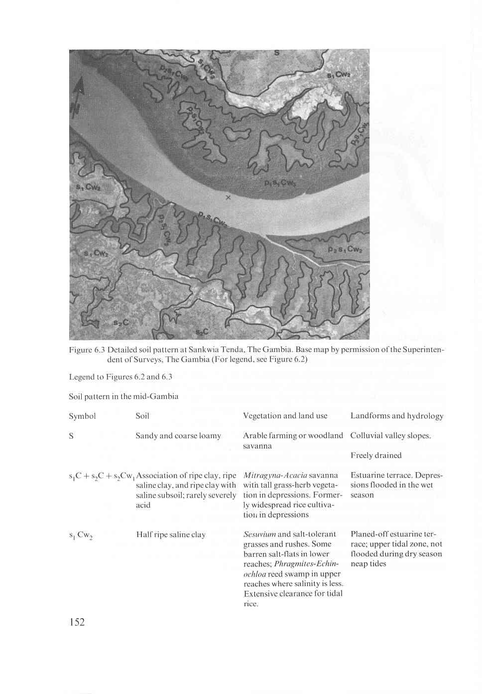
9 P2SICW2 Half ripe saline sulphidic clay A vicennia africana, Rhizophora mangle and R. racemosa mangroves; Phragmites- Echinochloa reed swamp. Extensive clearance for tidal rice.- PISICW3 Unripe saline sulphidic clay Tall Rhizophora racemosa mangroves Tidal flats, flooded by every high tide 6.4 Detailed soil patterns in the inter-tidal zone The soil patterns of the tidal zone evolve in concert with the sedimentary landscape. Regional soil patterns are related to changes in sea level and gross sedimentation. The characteristics of detailed patterns that are relevant to project feasibility and management commonly include: - An intricate distribution pattern of acid and non-acid soils; - Within any large area of acid sulphate or potential acid sulphate soils, a tenfold variation in pyrite content; - Lower pyrite content in the topsoil than in the subsoil; variation in thickness of non-acid topsoil; - Usually pyrite contents are greatest, and acid or potentially acid layers closest to the surface, in the lowest parts of the landscape (for example on the Bangkok Plain, van Breemen 1976); - Depositional landforms, such as sand bars and levees, and erosional features, such as estuarine terraces and relict islands or shields of sediment deposited under a relatively higher sea level, are conspicuous features of the soil pattern (for example Andriesse and Sim 1968; Dent 1980). Each sedimentary basin has a unique soil pattern. This is related to its particular environment and sedimentary history. The range of contrasting soil patterns is illustrated here by examples of detailed surveys from New Zealand and The Gambia. In Northland, New Zealand (see Figure 4.6), relative sea level seems to have been fairly stable over the last 2000 years. Extensive tidal landscapes in wide harbours have developed an intricate pattern of meandering tidal creeks, levees, and backswamps, illustrated by Figure 6.5. A more disciplined pattern, representative of constricted tidal river landscapes, is illustrated by Figure 6.6. In both landscapes, there is a correspondence between landform and soil morphology (Figures 6.7 and 6.8). Half ripe clays, with Go-Gro-Gr profiles, are developed on raised flats and levees that can drain quickly at low tide. Half ripe or unripe clays, with thick, sulphidic Gr horizons, are developed in the backswamps. Soil profile morphology is indicative of a range of chemical and physical soil properties. Pyrite content has been discussed already in relation to the characteristic horizons of the tidal soils (see Section 4.2). A comparison between Figures 6.7 and 6.9 illustrate the field relationships of the important geotechnical property, shear strength. In this instance, the shear strength of the saturated tidal soils is determined firstly by soil texture; the characteristics of sandy materials are quite distinct from clays. Within the clay soils, shear strength is most closely related to ripeness. 153
10
The Coast: Beaches and Shoreline Processes
 1 2 3 4 5 6 7 8 9 The Coast: es and Shoreline Processes Trujillo & Thurman, Chapter 10 Oceanography 101 Chapter Objectives Recognize the various landforms characteristic of beaches and coastal regions.
The Coast: Beaches and Shoreline Processes Trujillo & Thurman, Chapter 10
 The Coast: es and Shoreline Processes Trujillo & Thurman, Chapter 10 Oceanography 101 Chapter Objectives Recognize the various landforms characteristic of beaches and coastal regions. Identify seasonal
Types of Wetlands. Tidal Systems
 Types of Wetlands Tidal Systems 1 COASTAL WETLAND ECOSYSTEMS Tidal Salt Marshes Tidal Freshwater Marshes Mangrove Wetlands 2 Tidal Estuarine Wetland 3 Definition and Formation of Estuaries Estuary: : partially
Subtidal permanently flooded with tidal water. Irregularly exposed surface exposed by tides less often than daily
 Types of Wetlands Tidal Systems COASTAL WETLAND ECOSYSTEMS Tidal Salt Marshes Tidal Freshwater Marshes Mangrove Wetlands Tidal Estuarine Wetland 1 Definition and Formation of Estuaries u Estuary : partially
1 Shoreline Landforms 2. 2 Emergent v. Submergent 2. 3 Wavecutting 3. 4 Planview 4. 5 Marine Terraces 5. 6 California 7. 7 Tombolos, Sea Stacks 8
 Shorelines November 9, 2008 Contents 1 Shoreline Landforms 2 2 Emergent v. Submergent 2 3 Wavecutting 3 4 Planview 4 5 Marine Terraces 5 6 California 7 7 Tombolos, Sea Stacks 8 8 Active Processes 9 9 Emergence
Streams. Stream Water Flow
 CHAPTER 14 OUTLINE Streams: Transport to the Oceans Does not contain complete lecture notes. To be used to help organize lecture notes and home/test studies. Streams Streams are the major geological agents
Geol 117 Lecture 18 Beaches & Coastlines. I. Types of Coastlines A. Definition:
 I. Types of Coastlines A. Definition: 1. Shore = narrow zone where ocean meets land (e.g. beach) 2. Coast is a broad area where both ocean and land processes act a. Includes onshore marshes, dunes, sea
Supplemental Slides. Shore: Junction of Land & Water. Junction of Land & Water. Sea Level Variations. Shore vs. Coast. Sea Level Variations
 Shore: Junction of Land & Water Supplemental Slides Sediments come off land Most get dumped at the beach Sediment interacts with ocean waves and currents Junction of Land & Water Features: Breaking waves,
Shore: Junction of Land & Water. Sediments come off land Most get dumped at the beach Sediment interacts with ocean waves and currents
 Shore: Junction of Land & Water Supplemental Slides Sediments come off land Most get dumped at the beach Sediment interacts with ocean waves and currents Junction of Land & Water Features: Breaking waves,
Running Water Earth - Chapter 16 Stan Hatfield Southwestern Illinois College
 Running Water Earth - Chapter 16 Stan Hatfield Southwestern Illinois College Hydrologic Cycle The hydrologic cycle is a summary of the circulation of Earth s water supply. Processes involved in the hydrologic
EXTERNAL LAND FORMING PROCESSES
 NAME SCHOOL INDEX NUMBER DATE EXTERNAL LAND FORMING PROCESSES WEATHERING 1 1998 Q 7 (a) (i) What is the difference between weathering and mass wasting (ii) List five processes involved in chemical weathering
Science EOG Review: Landforms
 Mathematician Science EOG Review: Landforms Vocabulary Definition Term canyon deep, large, V- shaped valley formed by a river over millions of years of erosion; sometimes called gorges (example: Linville
2.2.7 Backbarrier flats
 FIGURE 24. VERTICAL PHOTOGRAPH SHOWING THE DEVELOPMENT OF SMALL PARABOLIC DUNES FROM BLOWOUTS IN A LARGE RELICT FOREDUNE NORTHWEST OF HUNTER'S CREEK. PHOTOGRAPH COURTESY OF CAR'T'ER HOLT HARVEY FORESTS
Chapter 2. Wearing Down Landforms: Rivers and Ice. Physical Weathering
 Chapter 2 Wearing Down Landforms: Rivers and Ice Physical Weathering Weathering vs. Erosion Weathering is the breakdown of rock and minerals. Erosion is a two fold process that starts with 1) breakdown
FLUVIAL LANDFORMS. Floodplains
 FLUVIAL LANDFORMS Floodplains fairly flat & continuous surface occupying much of a valley bottom normally underlain by unconsolidated sediments subject to periodic flooding (usually once every year or
Landscape Development
 Landscape Development Slopes Dominate Natural Landscapes Created by the interplay of tectonic and igneous activity and gradation Deformation and uplift Volcanic activity Agents of gradation Mass wasting
STREAM SYSTEMS and FLOODS
 STREAM SYSTEMS and FLOODS The Hydrologic Cycle Precipitation Evaporation Infiltration Runoff Transpiration Earth s Water and the Hydrologic Cycle The Hydrologic Cycle The Hydrologic Cycle Oceans not filling
Precipitation Evaporation Infiltration Earth s Water and the Hydrologic Cycle. Runoff Transpiration
 STREAM SYSTEMS and FLOODS The Hydrologic Cycle Precipitation Evaporation Infiltration Earth s Water and the Hydrologic Cycle Runoff Transpiration The Hydrologic Cycle The Hydrologic Cycle Oceans not filling
Developed in Consultation with Florida Educators
 Developed in Consultation with Florida Educators Table of Contents Next Generation Sunshine State Standards Correlation Chart... 7 Benchmarks Chapter 1 The Practice of Science...................... 11
Year 6. Geography. Revision
 Year 6 Geography Revision November 2017 Rivers and World knowledge How the water cycle works and the meaning of the terms evaporation, condensation, precipitation, transpiration, surface run-off, groundwater
Chapter 2. Denudation: Rivers and Ice
 Chapter 2. Denudation: Rivers and Ice DENUDATION: process that lowers level of land - caused by rivers, glaciers, waves & wind - involves processes of WEATHERING & EROSION Weathering Def: breakdown of
4.2 Tidal Wetlands. Phragmites Australis
 4.2 Tidal Wetlands Few topics elicit such strong emotions in Guilford as the current state of salt marshes. These marshes, more broadly known as tidal wetlands, are undergoing a transformation as sea level
Earth Science Chapter 9. Day 6 - Finish Capillary Action Lab - Quiz over Notes - Review Worksheets over Sections 9.2 and 9.3
 Earth Science Chapter 9 Day 1 Day 2 Day 3 Read Section 9.1 Surface Water Chapter 9 Term Sheet Notes over Section 9.1 Surface Water Section 9.1 Review Worksheets Quiz over Section 9.1 Notes Virtual Lab
Erosion Surface Water. moving, transporting, and depositing sediment.
 + Erosion Surface Water moving, transporting, and depositing sediment. + Surface Water 2 Water from rainfall can hit Earth s surface and do a number of things: Slowly soak into the ground: Infiltration
Fresh Water: Streams, Lakes Groundwater & Wetlands
 Fresh Water:, Lakes Groundwater & Wetlands Oct 27 Glaciers and Ice Ages Chp 13 Nov 3 Deserts and Wind and EXAM #3 Slope hydrologic cycle P = precip I = precip intercepted by veg ET = evapotranspiration
1. Any process that causes rock to crack or break into pieces is called physical weathering. Initial product = final product
 Weathering 1. Any process that causes rock to crack or break into pieces is called physical weathering. Initial product = final product End Result of physical weathering is increased surface area. 2. Physical
STUDY AREA AND METHODOLOGY
 . CHAPTER 2 STUDY AREA AND METHODOLOGY 26 CHAPTER 2 STUDY AREA AND METHODOLOGY Kundalika is a major river in konkan region of Maharashtra. River originates in Western Ghats at an altitude of 820 m ASL
Surface Processes Focus on Mass Wasting (Chapter 10)
") Surface Processes Focus on Mass Wasting (Chapter 10) 1. What is the distinction between weathering, mass wasting, and erosion? 2. What is the controlling force in mass wasting? What force provides resistance?
Surface Processes Focus on Mass Wasting (Chapter 10) 1. What is the distinction between weathering, mass wasting, and erosion? 2. What is the controlling force in mass wasting? What force provides resistance?
Landscapes & Hydric Soils Bruce Vasilas University of Delaware
 Landscapes & Hydric Soils Bruce Vasilas University of Delaware Hydric soils are defined as soils that formed under conditions of saturation, flooding, or ponding long enough during the growing season to
accumulation or sedimentation of pyrite and acid neutralizing components
 FACTORS INFLUENCING THE FORMATION OF POTENTIAL ACIDITY IN TIDAL SWAMPS L. J. Pons and N. van Breemen Department of Soil Science and Geology, Agricul tural University Wageningen, The Netherlands Summary
RALPH SIMMONS STATE FOREST 2016 LAND MANAGEMENT PLAN EXHIBITS
 RALPH SIMMONS STATE FOREST 2016 LAND MANAGEMENT PLAN EXHIBITS EXHIBIT A Location Map Exhibit A EXHIBIT B Management Accomplishment Summary for RSSF EXHIBIT C Proximity to Other Public Lands Exhibit C
Physical Geography A Living Planet
 Physical Geography A Living Planet The geography and structure of the earth are continually being changed by internal forces, like plate tectonics, and external forces, like the weather. Iguaçu Falls at
Coastal Oceanography. Coastal Oceanography. Coastal Waters
 Coastal Oceanography Coastal Oceanography 95% of ocean life is in coastal waters (320 km from shore) Estuaries and wetlands are among most productive ecosystems on Earth Major shipping routes, oil and
9 th INTECOL Orlando, Florida June 7, 2012
 Restoration of the Everglades Saline Wetlands and Florida Bay: Responses Driven from Land and Sea David Rudnick 1, Colin Saunders 2, Carlos Coronado 2, Fred Sklar 2 Erik Stabenau 1, Vic Engel 1, Rene Price
3.3 CLIMATE, GEOLOGY, TOPOGRAPHY, AND SOILS CLIMATE GEOLOGY TOPOGRAPHY
 3.3 CLIMATE, GEOLOGY, TOPOGRAPHY, AND SOILS This section describes the climate, geology, topography, and soil resource characteristics of the Yolo Bypass Wildlife Area (Wildlife Area). Agricultural soil
Erosion and Deposition
 CHAPTER 3 LESSON 2 Erosion and Deposition Landforms Shaped by Water and Wind Key Concepts What are the stages of stream development? How do water erosion and deposition change Earth s surface? How do wind
Cattaraugus Creek: A Story of Flowing Water and the Geology of the Channel It Flows Through Presentation to West Valley Citizen Task Force 4/27/16
 Cattaraugus Creek: A Story of Flowing Water and the Geology of the Channel It Flows Through Presentation to West Valley Citizen Task Force 4/27/16 Raymond C. Vaughan, Ph.D. What happens if you drop a
Weathering, Erosion, Deposition, and Landscape Development
 Weathering, Erosion, Deposition, and Landscape Development I. Weathering - the breakdown of rocks into smaller particles, also called sediments, by natural processes. Weathering is further divided into
Taunton River Salt Marsh Assessment Results from 2014 season
 Taunton River Salt Marsh Assessment Results from 2014 season December, 2014 During the late summer and fall of 2014, Save The Bay evaluated salt marshes in Assonet Bay, Freetown and Broad Cove in Dighton
RIVERS, GROUNDWATER, AND GLACIERS
 RIVERS, GROUNDWATER, AND GLACIERS Delta A fan-shaped deposit that forms when a river flows into a quiet or large body of water, such as a lake, an ocean, or an inland sea. Alluvial Fan A sloping triangle
Extra Credit Assignment (Chapters 4, 5, 6, and 10)
") GEOLOGY 306 Laboratory Instructor: TERRY J. BOROUGHS NAME: Extra Credit Assignment (Chapters 4, 5, 6, and 10) For this assignment you will require: a calculator and metric ruler. Chapter 4 Objectives:
GEOLOGY 306 Laboratory Instructor: TERRY J. BOROUGHS NAME: Extra Credit Assignment (Chapters 4, 5, 6, and 10) For this assignment you will require: a calculator and metric ruler. Chapter 4 Objectives:
Reading Material. See class website. Sediments, from Oceanography M.G. Gross, Prentice-Hall
 Reading Material See class website Sediments, from Oceanography M.G. Gross, Prentice-Hall Materials filling ocean basins Dissolved chemicals especially from rivers and mid-ocean ridges (volcanic eruptions)
Geology and New England Landscapes
 Geology and New England Landscapes Jim Turenne, CPSS USDA-NRCS Warwick, RI. http://nesoil.com Why Geology? Provides the big picture of site conditions. Major part of soil formation (parent material and
Final Exam. Running Water Erosion and Deposition. Willamette Discharge. Running Water
 Final Exam Running Water Erosion and Deposition Earth Science Chapter 5 Pages 120-135 Scheduled for 8 AM, March 21, 2006 Bring A scantron form A calculator Your 3 x 5 paper card of formulas Review questions
What landforms make up Australia?!
 What landforms make up Australia? The tectonic forces of folding, faulting and volcanic activity have created many of Australia's major landforms. Other forces that work on the surface of Australia, and
Earth Science Chapter 6 Section 2 Review
 Name: Class: Date: Earth Science Chapter 6 Section Review Multiple Choice Identify the choice that best completes the statement or answers the question. 1. Most streams carry the largest part of their
Moosehead Lake and the Tale of Two Rivers
 Maine Geologic Facts and Localities June, 2005 45 o 53 5.09 N, 69 o 42 14.54 W Text by Kelley, A.R.; Kelley, J.T.; Belknap, D.F.; and Gontz, A.M. Department of Earth Sciences, University of Maine, Orono,
Streams. Water. Hydrologic Cycle. Geol 104: Streams
 Streams Why study streams? Running water is the most important geologic agent in erosion, transportation and deposition of sediments. Water The unique physical and chemical properties of water make it
STUDY GUIDE FOR CONTENT MASTERY. Surface Water Movement
 Surface Water SECTION 9.1 Surface Water Movement In your textbook, read about surface water and the way in which it moves sediment. Complete each statement. 1. An excessive amount of water flowing downslope
Bell Ringer. Are soil and dirt the same material? In your explanation be sure to talk about plants.
 Bell Ringer Are soil and dirt the same material? In your explanation be sure to talk about plants. 5.3 Mass Movements Triggers of Mass Movements The transfer of rock and soil downslope due to gravity is
Name. 4. The diagram below shows a soil profile formed in an area of granite bedrock. Four different soil horizons, A, B, C, and D, are shown.
 Name 1. In the cross section of the hill shown below, which rock units are probably most resistant to weathering? 4. The diagram below shows a soil profile formed in an area of granite bedrock. Four different
Australian Coastal Councils Conference
 Australian Coastal Councils Conference 11 March 2015 Estimating Future Coastal Inundation and Erosion Hazards Dr Andrew McCowan Dr Christine Lauchlan-Arrowsmith Warwick Bishop Background Victorian Future
Chapter 5. The Sedimentary Archives
 Chapter 5 The Sedimentary Archives Factors affecting Sedimentary Characteristics 1. Tectonic setting 2. Physical, chemical, and biological processes in the depositional environment 3. Method of sediment
Weathering, Erosion and Deposition
 Weathering, Erosion and Deposition Shaping the Earth s Surface Weathering the process of breaking down rocks into smaller fragments Erosion the transport of rock fragments from one location to another
6.1 Water. The Water Cycle
 6.1 Water The Water Cycle Water constantly moves among the oceans, the atmosphere, the solid Earth, and the biosphere. This unending circulation of Earth s water supply is the water cycle. The Water Cycle
GEOL 1121 Earth Processes and Environments
 GEOL 1121 Earth Processes and Environments Wondwosen Seyoum Department of Geology University of Georgia e-mail: seyoum@uga.edu G/G Bldg., Rm. No. 122 Seyoum, 2015 Chapter 6 Streams and Flooding Seyoum,
Wetland Sediment Dynamics at Crissy Field Marsh Annual Report
 Wetland Sediment Dynamics at Crissy Field Marsh 27 Annual Report John Callaway Department of Environmental Science University of San Francisco 217 Fulton St. San Francisco, CA 94117 (415) 422-572 callaway@usfca.edu
Terrain Units PALEOGEOGRAPHY: LANDFORM CREATION. Present Geology of NYS. Detailed Geologic Map of NYS
 NYS TOPOGRAPHY Why so? PALEOGEOGRAPHY: LANDFORM CREATION Prof. Anthony Grande AFG 014 Present Geology of NYS Detailed Geologic Map of NYS Generalized Geology Detailed Geology Hot links to the fold out
Soil Formation. Lesson Plan: NRES B2-4
 Soil Formation Lesson Plan: NRES B2-4 1 Anticipated Problems 1. What are five different factors that affect soil formation? 2. What are some different types of parent material that affect soils? 3. What
Name: Date: Class: Louisiana: Our History, Our Home Chapter 1: Louisiana s Geography - Section 2: Natural Regions Guided Reading
 Instructions: Read the section and complete each item with words from the passages in this section. 1. The diversity of Louisiana s can surprise residents and visitors alike. 2. Physical geography is concerned
' International Institute for Land Reclamation and Improvement. 2 Groundwater Investigations. N.A. de Ridder'? 2.1 Introduction. 2.
 2 Groundwater Investigations N.A. de Ridder'? 2.1 Introduction Successful drainage depends largely on a proper diagnosis of the causes of the excess water. For this diagnosis, one must consider: climate,
COASTAL QUATERNARY GEOLOGY MAPPING FOR NSW: EXAMPLES AND APPLICATIONS
 COASTAL QUATERNARY GEOLOGY MAPPING FOR NSW: EXAMPLES AND APPLICATIONS A Troedson Geological Survey of New South Wales Abstract Detailed geological mapping of the coastal plains of regional NSW was undertaken
Changes in Texas Ecoregions
 Comment On Lesson Changes in Texas Ecoregions The state of Texas can be divided into 10 distinct areas based on unique combinations of vegetation, topography, landforms, wildlife, soil, rock, climate,
Erosion and Deposition
 Erosion and Deposition Erosion Sediment natural forces move rock/soil from one place to another. gravity, water, wind, glaciers, waves are causes material moved by erosion Deposition when erosion lays
Ms. A. Mormando's Class *
 8 th Grade Science Essential Standard: 8.E.1.1 Explain the structure of the hydrosphere including: Water distribution on Earth; Local river basin and water availability Stream - A stream is a body of water
Page 1. Name:
 Name: 1) Which event is the best example of erosion? dissolving of rock particles on a limestone gravestone by acid rain breaking apart of shale as a result of water freezing in a crack rolling of a pebble
PALEOGEOGRAPHY of NYS. Definitions GEOLOGIC PROCESSES. Faulting. Folding 9/6/2012. TOPOGRAPHIC RELIEF MAP of NYS GRADATIONAL TECTONIC
 TOPOGRAPHIC RELIEF MAP of NYS PALEOGEOGRAPHY of NYS Prof. Anthony Grande AFG 2012 Definitions GEOLOGIC PROCESSES Geography: study of people living on the surface of the earth. Geology: the scientific study
ON THE EVOLUTION OF A HOLOCENE BARRIER COAST
 ON THE EVOLUTION OF A HOLOCENE BARRIER COAST Response to sea-level change and sediment supply DANCORE Seminar 2014 COADAPT - Danish Coasts and Climate Adaptation Flooding Risk and Coastal Protection Mikkel
ES 105 Surface Processes I. Hydrologic cycle A. Distribution % in oceans 2. >3% surface water a. +99% surface water in glaciers b.
 ES 105 Surface Processes I. Hydrologic cycle A. Distribution 1. +97% in oceans 2. >3% surface water a. +99% surface water in glaciers b. >1/3% liquid, fresh water in streams and lakes~1/10,000 of water
Topic 6: Weathering, Erosion and Erosional-Deposition Systems (workbook p ) Workbook Chapter 4, 5 WEATHERING
 Workbook Chapter 4, 5 WEATHERING") Topic 6: Weathering, Erosion and Erosional-Deposition Systems (workbook p. 95-125) Workbook Chapter 4, 5 THE BIG PICTURE: Weathering, erosion and deposition are processes that cause changes to rock material
Topic 6: Weathering, Erosion and Erosional-Deposition Systems (workbook p. 95-125) Workbook Chapter 4, 5 THE BIG PICTURE: Weathering, erosion and deposition are processes that cause changes to rock material
Mangrove Erosion in the Mekong delta
 Mangrove Erosion in the Mekong delta 1. Introduction a. Mangrove coast - a balance between different forcing factors Mangroves are coastal environments frequently observed in the tropical muddy coasts.
Laboratory Exercise #3 The Hydrologic Cycle and Running Water Processes
 Laboratory Exercise #3 The Hydrologic Cycle and Running Water Processes page - 1 Section A - The Hydrologic Cycle Figure 1 illustrates the hydrologic cycle which quantifies how water is cycled throughout
Chapter 3 Sedimentation of clay minerals
 Chapter 3 Sedimentation of clay minerals 3.1 Clay sedimentation on land 3.2 From land to sea 3.3 Clay sedimentation in the sea 1 3.1 Clay sedimentation on land Deserts Glaciers Rivers Lacustrine 2 University
Permafrost-influenced Geomorphic Processes
 Section 4 Permafrost-influenced Geomorphic Processes Geomorphic processes vary greatly among ecoregions in northern Alaska, extending from the Beaufort Sea coast to the Brooks Range (Figure 4.1). Regional
Surface Water and Stream Development
 Surface Water and Stream Development Surface Water The moment a raindrop falls to earth it begins its return to the sea. Once water reaches Earth s surface it may evaporate back into the atmosphere, soak
Summary. Streams and Drainage Systems
 Streams and Drainage Systems Summary Streams are part of the hydrologic cycle and the chief means by which water returns from the land to the sea. They help shape the Earth s surface and transport sediment
Essential Questions. What is erosion? What is mass wasting?
 Erosion Essential Questions What is erosion? What is mass wasting? What is Erosion? Erosion The transportation of sediment from one area to another Caused mainly by running water but also caused by glaciers,
Biosphere. All living things, plants, animals, (even you!) are part of the zone of the earth called the biosphere.
 are part of the zone of the earth called the biosphere.") Unit 1 Study Guide Earth s Spheres Biosphere All living things, plants, animals, (even you!) are part of the zone of the earth called the biosphere. Hydrosphere Water covers ¾ of the earth, made up mostly
Unit 1 Study Guide Earth s Spheres Biosphere All living things, plants, animals, (even you!) are part of the zone of the earth called the biosphere. Hydrosphere Water covers ¾ of the earth, made up mostly
Landforms in Canada. Canada is made up of three dis;nct types of landforms: Canadian Shield Highlands Lowlands
 Canada s Landforms What is a Landform? A landform is any physical feature of the Earth s surface having a characteris;c, recognizable shape, produced by natural causes. Landforms include major features
Coasts Key Word Glossary
 Coasts Key Word Glossary Abrasion Also known as corrosion. It is the wearing away of the cliff by sand, fragments of rock and boulders that are being hurled at the cliff by the waves. It causes grinding
Day 3 Weathering and Erosion.notebook. October 02, Section 7.2. Erosion and Deposition. Objectives
 Objectives Describe the relationship of gravity to all agents of erosion. Contrast the features left from different types of erosion. Analyze the impact of living and nonliving things on the processes
The Marine Environment
 The Marine Environment SECTION 16.1 Shoreline Features In your textbook, read about erosional landforms, beaches, estuaries, longshore currents, and rip currents. For each statement below, write or. 1.
L7/ Historical Perspec=ve, Deltas
 Colin Woodroffe (2002) Coasts: Form, Process and Evolu=on, Outline of Chapter 7: L7/1 L7/2 7.1. Historical Perspec=ve, 7.1.1. Deltas Herodotus (450, B.C.) delta = Shape of Nile River Delta = Δ Gilbert
The Marine Environment
 The Marine Environment SECTION 16.1 Shoreline Features In your textbook, read about erosional landforms, beaches, estuaries, longshore currents, and rip currents. For each statement below, write true or
Controlling Processes That Change Land
 1 Name Date Controlling Processes That Change Land People try to control some of the processes that change land. To do this, people apply technology- the use of science to solve problems in everyday life.
What are the different ways rocks can be weathered?
 Romano - 223 What are the different ways rocks can be weathered? Weathering - the breakdown of rocks and minerals at the Earth s surface 1. 2. PHYSICAL WEATHERING Rock is broken into smaller pieces with
EARTH S CHANGING SURFACE
 EARTH S CHANGING SURFACE Weathering Together, weathering and erosion work continuously to wear down the material on Earth s surface. weathering process that breaks down rock and other substances of Earth
Coastal Tidal Marshes
 Virginia s Wetlands Coastal Tidal Marshes Hydrology driven by lunar tides; Stresses include tidal inundation and/or salts; Found along high latitudes along intertidal coasts; Comprise ~ 70% wetlands of
Chapter 2. Regional Landscapes and the Hydrologic Cycle
 Chapter 2. Regional Landscapes and the Hydrologic Cycle W. Lee Daniels Department of Crop and Soil Environmental Sciences, Virginia Tech Table of Contents Introduction... 23 Soils and landscapes of the
Quick Clay: (Leda Clay gone bad!) Origin, Mineralogy, Chemistry and Landslides
 Origin, Mineralogy, Chemistry and Landslides") Quick Clay: (Leda Clay gone bad!) Origin, Mineralogy, Chemistry and Landslides What is Leda Clay? The fine-grained (silty clay and clayey silt) sediments that accumulated in the St. Lawrence drainage basin,
Quick Clay: (Leda Clay gone bad!) Origin, Mineralogy, Chemistry and Landslides What is Leda Clay? The fine-grained (silty clay and clayey silt) sediments that accumulated in the St. Lawrence drainage basin,
Section 2.1 Ocean Basins. - Has helped determine where ocean basins are located. - Tectonic plates move changing the position of the continents.
 Science 8 Unit 1: Water Systems on Earth Chapter 2: Oceans Control the Water Cycle Section 2.1 Ocean Basins Oceans are important because: 1. Primary water source for the water cycle 2. Control weather
Weathering, Erosion, Deposition
 Weathering, Erosion, Deposition The breakdown of rocks at or near the Earth s Surface. Physical Chemical - The breakdown of rock into smaller pieces without chemical change. - Dominant in moist /cold conditions
mountain rivers fixed channel boundaries (bedrock banks and bed) high transport capacity low storage input output
 high transport capacity low storage input output") mountain rivers fixed channel boundaries (bedrock banks and bed) high transport capacity low storage input output strong interaction between streams & hillslopes Sediment Budgets for Mountain Rivers Little
mountain rivers fixed channel boundaries (bedrock banks and bed) high transport capacity low storage input output strong interaction between streams & hillslopes Sediment Budgets for Mountain Rivers Little
Pratice Surface Processes Test
 1. The cross section below shows the movement of wind-driven sand particles that strike a partly exposed basalt cobble located at the surface of a windy desert. Which cross section best represents the
The Effect of Weather, Erosion, and Deposition in Texas Ecoregions
 The Effect of Weather, Erosion, and Deposition in Texas Ecoregions 7.8B: I can analyze the effects of weathering, erosion, and deposition on the environment in ecoregions of Texas Weathering The breakdown
MISSISSIPPI RIVER DELTA OVERVIEW
 MISSISSIPPI RIVER DELTA OVERVIEW Science and Engineering Special Team Conference Louisiana State University October 9, 2012 Introduction Basics of the Mississippi Delta Natural and Human-Induced Land Loss
GLY Coastal Geomorphology Notes
 GLY 4734 - Coastal Geomorphology Notes Dr. Peter N. Adams Spring 2011 2 Coastal Classification In this lecture, we discuss some successful classification schemes of the coastal landscape, and pay particular
Science 8 - Water Systems Test - Chapters 1-2
 Science 8 - Water Systems Test - Chapters 1-2 Multiple Choice (30 marks) Identify the choice that best completes the statement or answers the question. 1. What percentage represents the amount of fresh
Physical landscapes River landscapes in the UK
 Physical landscapes River landscapes in the UK The shape of river valleys change s as rivers flow downstream - PROCESSES Erosion Abrasion or corrasion Attrition Hydraulic Action Solution or corrosion Deposition
PART 4 GEOLOGIC SETTING AND FOUNDATION CONDITIONS IN NEW ORLEANS
 PART 4 GEOLOGIC SETTING AND FOUNDATION CONDITIONS IN NEW ORLEANS The modern Mississippi Delta has been deposited during the past 6000 years, in four major areas. Current interpretation of the modern delta.