Development and formation process of sand dunes in Finland
|
|
|
- Elisabeth Lyons
- 5 years ago
- Views:
Transcription


1 Development and formation process of sand dunes in Finland Prof. Jukka Käyhkö Department of Geography and Geology University of Turku
2 Wind action aeolian processes Airflow: erodes land surface, transports and accumulates sediment Aeolian action is strongest in windy areas with dry, fine-grained sediment (+/- sand fraction) and sparse vegetation cover Deserts and semi-deserts (steppes) Coasts, river deltas etc. with abundant sediment source Glacial / periglacial environments

3 Global distribution of major deposits of aeolian derived sediments Physical Geography.net
. Information on dune coasts from Carter et al.")
4 Global distribution of aeolian sediments, and current activity status (after Thomas, 1997). Information on dune coasts from Carter et al. (1990)
5 Dunes in Finland Three main types / regions: Coastal dunes along the Baltic coast active Inland dunes adjacent to glaciofluvial deposits (forested) stable, vegetated Inland dunes in Lapland adjacent to glaciofluvial deposits near the pine forest line partially/cyclically active

6 Large inactive parabolic dune field at Rokuanvaara, on the western shore of Lake Oulujärvi (Airborne Lidar-DEM; maankamara.fi)

7 Small stable parabolic dune field at Lake Muddusjärvi, Inari, Lapland (Airborne Lidar-DEM: maankamara.fi)

 Kiellajoki,")
8 n. 500 m Stable parabolic dunes with reactivated crests (white) Kiellajoki, Inari


9 Largest occurrences of aeolian activity coincide with major glaciolacustrine deposits outside pine forest Aeolian activity in northern Lapland Käyhkö 1997


10 The largest active parabolic dune in Finland, Melajärvi, Enontekiö Mountain birch scrub (false-colour air photo) Fine sand Resistant exposed silty deposit Buried trees 100 m

11 Europe during the last glaciation, approximately 20,000 to 70,000 years before present. Finnish coastal dunes and land uplift

12 Deglaciation pattern and chronology for the Fennoscandian Ice Sheet. Stroeven et al Quaternary Science Reviews 147, Yyteri
 By Erik Ivins, JPL.")

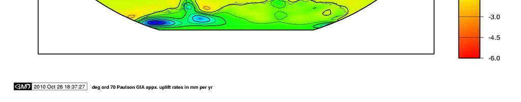
13 Glacial isostatic uplift (GIA), or Postglacial rebound (PGR) By Erik Ivins, JPL. - ftp://podaac.jpl.nasa.gov/alldata/tellus/l3/pgr/browse/pgr_paulson2007_rate_of_lithospheric_uplift_due_to_pgr.png, Public Domain,


14 Land uplift rate mm/year Yyteri ca. 6.5 mm Supra- and subaquatic regions in Finland

15
 November 2002 & Stroeven et al.")
16 Finland and the Yoldia Sea ca 12,700 cal BP Fennia Vol. 180, No. 1 2 (incl. CD) November 2002 & Stroeven et al. QSR 2016

17 1400 AD
18 Sea level (cm, N2000) Year Finnish Met. Inst. FMI:


19


20 Dunes on Finnish coasts are located adjacent to glaciofluvial deposits Esker, delta (gravel and sand) Rather rare feature only 1300 ha of coastal dunes in Finland Sandy sediments of the sea bottom become exposed due to land uplift Sediment source for coastal dunes Nylén 2015
21 Sediment transport Key factors: 1) Airflow atmospheric boundary layer 2) Forces that affect sand grain 3) Threshold shear velocity 4) Other factors that affect particle entrainment (e.g. moisture content, salinity) 5) Particle flight paths and chain reactions caused by bouncing particles
22 Aeolian processes (1) Airflow properties: Low viscosity (+15 C: n = m -2 s -1 ) Low density (r = 1.23 kg m -3 ) High speed > turbulent flow Reynolds number determines the threshold between laminar and turbulent flow Re = LU/n, where L is length (here: diameter), U speed, and n viscosity Re > 6000 = turbulent flow; in practice > 0.1 m/s speed Wind speed 0-height: d/30, where d is particle size Logarithmic velocity gradient
23 Logarithmic wind speed profile determined by surface roughness (friction)
24 Aeolian processes (2) Wind speed at sand surface ( wind stress ) Shear stress u * ( u-star ) u * = U/[(1/κ)ln(z/d) + C], where U is wind speed (m/s) at elevation z (m), d is sediment grain size (m), κ [kappa] is von Kármán constant (0,4), C is empirical constant 8,48
25 When does sand start to move? threshold wind speed for sand (Bagnold 1941) s - r u * t = A gd Ł r ł where A is constant 0.1 (when d > 80 µm) σ is particle density ρ is air density g is acceleration of gravity d is particle diameter

26
27 How much sand is moved? transport amount (Bagnold 1941) q = C where Ł ł g q is mass of transported sand per gate width and time C is constant (between 1.5 and 3.5, for normal dune sand 1.8) ρ is air density g is acceleration of gravity and d is mean particle size (=d50) D is particle standard diameter of 250 mm u * is shear stress d D r u*3,
28 Sand dunes A bedform of loose sand Typically quartz grains (resistant), also other minerals ca. 200 μm diameter three scales: ripples; centimetres desimetres dunes; tens of metres hundreds of metres draa-formations; hundreds of meters - kilometers these formations do not grow from one form to another, but occur simultaneously (overlapping)

29 Gary Nichols: Sedimentology & Stratigraphy. Wiley.


30 Ripple dynamics Dune dynamics Gary Nichols: Sedimentology & Stratigraphy. Wiley.
31 Sand Dune Development Starts from an embryo dune (nebkha) accumulation is triggered by an obstacle (grass tussock, rock, hump etc.) that causes turbulence Many dunes migrate gradually downwind Sand grain climbs up the stoss slope, over the dune crest and falls down on the slip face (=lee face), which has a typical angle of repose (ca. 30 )
32 Angle of repose (lepokulma in Finnish) The steepest possible angle for a sediment (in the absence of vegetation, excessive moisture etc.) Measurement of the angle of repose: Different sediments have slightly different angles of repose:
33 Coastal dunes system in Yyteri four dune types from the beach towards inland Shifting embryo dunes deposited on the back beach with the help of Leymus (sea lyme grass) and Honkenya (sea sandwort) Shifting foredunes covered with Leymus ( white dunes ) Fixed coastal dunes with grasses, herbs, mosses, lichens ( grey dunes ) Forested dunes with Pinus (Scots pine) on stoss slopes and deciduous species (Betula, Sorbus, Alnus) on steep slipfaces
34 Council Directive 92/43/EEC of 21 May 1992 on the conservation of natural habitats and of wild fauna and flora 2. COASTAL SAND DUNES AND INLAND DUNES 21. Sea dunes of the Atlantic, North Sea and Baltic coasts The dune types found in Yyteri are marked with red (approx. area in ha) 2110 Embryonic shifting dunes (2 ha) 2120 Shifting dunes along the shoreline with Ammophila arenaria ( white dunes ) (10 ha) 2130 * Fixed coastal dunes with herbaceous vegetation ( grey dunes ) (25 ha) 2140 * Decalcified fixed dunes with Empetrum nigrum 2150 * Atlantic decalcified fixed dunes (Calluno-Ulicetea) 2160 Dunes with Hippophaë rhamnoides 2170 Dunes with Salix repens ssp. argentea (Salicion arenariae) 2180 Wooded dunes of the Atlantic, Continental and Boreal region (55 ha) 2190 Humid dune slacks (0.4 ha) 21A0 Machairs (* in Ireland) Total area of the five different dune types: 93 ha, or ca. 1 km 2

35


36 Natural habitat types of Yyterinsannat (for codes in English, see slide 34)
37 Wind erosion: deflation Occurs naturally on many dune types (e.g. parabel) and regions (e.g. surrounding glaciated terrains) Often accelerated by human activity (agriculture, grazing) when vegetation cover is sparse and sediment is fine (silt, loess) Ultimate example: the Dust Bowl of the 1930 s in the United States


38 Wind furrows Exposed roots, deflation Burial by deposition Yyteri Sands; examples of practical challenges
39 Summary: Dunes along the coasts of Finland are governed by: sandy glaciofluvial deposits on the shore and the sea bottom gentle coastal profile isostatic land uplift when these circumstances are met coastal dune formation Concern about dune management specifically in two environments: Active coastal dunes with high anthropogenic pressure Partially active dunes of Lapland, related to e.g. grazing pressure by reindeer (although much of the activity seems to be natural)
EOLIAN PROCESSES & LANDFORMS
 EOLIAN PROCESSES & LANDFORMS Wind can be an effective geomorphic agent under conditions of sparse vegetation & abundant unconsolidated sediment egs. hot & cold deserts, beaches & coastal regions, glacial
every continent has an extensive dry region! " deserts are as much as 1/3 of Earth s surface!
 deserts! deserts! every continent has an extensive dry region! " deserts are as much as 1/3 of Earth s surface! Hollywood portrayal of vast stretches of sand dune! " Sahara has only 10% covered by sand!
Physical Geology, 15/e
 Lecture Outlines Physical Geology, 15/e Plummer, Carlson & Hammersley Deserts & Wind Action Physical Geology 15/e, Chapter 13 Deserts Desert any arid region that receives less than 25 cm of precipitation
GEOL 440 Sedimentology and stratigraphy: processes, environments and deposits. Lectures 17 & 18: Aeolian Facies
 GEOL 440 Sedimentology and stratigraphy: processes, environments and deposits Lectures 17 & 18: Aeolian Facies Today: Processes air/water differences Deposits bedforms Facies a little on models and controls
Mass Movements, Wind, and Glaciers
 Mass Movements,, and Glaciers SECTION 8.1 Mass Movement at Earth s Surface In your textbook, read about mass movement. Use each of the terms below just once to complete the passage. avalanche creep landslide
MASS MOVEMENTS, WIND, AND GLACIERS
 Date Period Name MASS MOVEMENTS, WIND, AND GLACIERS SECTION.1 Mass Movements In your textbook, read about mass movements. Use each of the terms below just once to complete the passage. avalanche creep
2/23/2009. Visualizing Earth Science. Chapter Overview. Deserts and Drylands. Glaciers and Ice Sheets
 Visualizing Earth Science By Z. Merali and B. F. Skinner Chapter 6 Deserts, Glaciers and Ice Sheets Chapter Overview Deserts and Drylands Glaciers and Ice Sheets Deserts Geography Categorization of deserts
Chapter 9 Notes: Ice and Glaciers, Wind and Deserts
 Chapter 9 Notes: Ice and Glaciers, Wind and Deserts *Glaciers and Glacial Features glacier is a mass of ice that moves over land under its own weight through the action of gravity Glacier Formation must
Aeolian Environments and Controls on Sedimentation. Alex Bryk, Ron Cash, Jacob Wikle, Rebecca Alberts
 Aeolian Environments and Controls on Sedimentation Alex Bryk, Ron Cash, Jacob Wikle, Rebecca Alberts Aeolian dunes develop in desert systems where there is an abundance of sand-grade material available
Essential Questions. What is erosion? What is mass wasting?
 Erosion Essential Questions What is erosion? What is mass wasting? What is Erosion? Erosion The transportation of sediment from one area to another Caused mainly by running water but also caused by glaciers,
Patrick Hesp. Department of Geography and Anthropology, Louisiana State University
 Patrick Hesp Department of Geography and Anthropology, Louisiana State University Incipient ( embryo ) Foredunes - new, or developing foredunes formed by aeolian sand deposition within pioneer plant communities
The Effect of Weather, Erosion, and Deposition in Texas Ecoregions
 The Effect of Weather, Erosion, and Deposition in Texas Ecoregions 7.8B: I can analyze the effects of weathering, erosion, and deposition on the environment in ecoregions of Texas Weathering The breakdown
Name: Class: Date: Multiple Choice Identify the letter of the choice that best completes the statement or answers the question.
 Name: Class: Date: geology ch 7 test 2008 Multiple Choice Identify the letter of the choice that best completes the statement or answers the question. 1. Which of the following is true about ice sheets?
Pratice Surface Processes Test
 1. The cross section below shows the movement of wind-driven sand particles that strike a partly exposed basalt cobble located at the surface of a windy desert. Which cross section best represents the
The Agents of Erosion
 The Agents of Erosion 1. Erosion & Deposition 2. Water 3. Wind 4. Ice California Science Project 1 1. Erosion and Deposition Erosion is the physical removal and transport of material by mobile agents such
Prentice Hall EARTH SCIENCE
 Prentice Hall EARTH SCIENCE Tarbuck Lutgens Chapter 7 Glaciers, Desert, and Wind 7.1 Glaciers Types of Glaciers A glacier is a thick ice mass that forms above the snowline over hundreds or thousands of
Erosion and Deposition
 Erosion and Deposition Erosion Sediment natural forces move rock/soil from one place to another. gravity, water, wind, glaciers, waves are causes material moved by erosion Deposition when erosion lays
Erosion and Deposition
 CHAPTER 3 LESSON 2 Erosion and Deposition Landforms Shaped by Water and Wind Key Concepts What are the stages of stream development? How do water erosion and deposition change Earth s surface? How do wind
E1212 Vol. 3 I~~~~~~~~~~~~~~~~~~~~~~~~~~~~~~~~~~~~~~~~~~~~~~~~~~~~~~~~~~~~~~~~~~~~~~~~~~~~~~~~~~~~~~~~~~~~~~~~~~~~~~~~~~~~~~
 Public Disclosure Authorized Public Disclosure Authorized Public Disclosure Authorized Public Disclosure Authorized EU Tacis: Joint Environment Programme 11 FOREST PROTECTION AND REFORESTATION PROJECT,
Aeolian Environments. And Controls on Sedimentation. John Luchok, Kyle Balling, Cristopher Alvarez
 Aeolian Environments And Controls on Sedimentation John Luchok, Kyle Balling, Cristopher Alvarez The Aeolian Environment Aeolian Processes - geologic activity with regards to wind Desert Environments (Hyper-Arid,
UNIT SEVEN: Earth s Water. Chapter 21 Water and Solutions. Chapter 22 Water Systems. Chapter 23 How Water Shapes the Land
 UNIT SEVEN: Earth s Water Chapter 21 Water and Solutions Chapter 22 Water Systems Chapter 23 How Water Shapes the Land Chapter Twenty-Three: How Water Shapes the Land 23.1 Weathering and Erosion 23.2
Holocene dune reactivation along the northern Curonian Spit: geological, paleoecological, and archaeological implications
 Holocene dune reactivation along the northern Curonian Spit: geological, paleoecological, and archaeological implications Ilya Buynevich Temple University (USA) Collaborators: Albertas Bitinas Donatas
Aqueous and Aeolian Bedforms
 Aqueous and Aeolian Bedforms 1 Further reading & review articles R.A. Bagnold, 1941, The physics of blown sand and desert dunes Charru et al., 2013, Sand ripples and dunes, Ann. Review of Fluid Mech. 2
Chapter 5: Glaciers and Deserts
 I. Glaciers and Glaciation Chapter 5: Glaciers and Deserts A. A thick mass of ice that forms over land from the compaction and recrystallization of snow and shows evidence of past or present flow B. Types
GEL 109 Midterm W01, Page points total (1 point per minute is a good pace, but it is good to have time to recheck your answers!
 GEL 109 Midterm W01, Page 1 50 points total (1 point per minute is a good pace, but it is good to have time to recheck your answers!) 1. Where in a water flow is there usually a zone of laminar flow even
EXAMPLES (SEDIMENT TRANSPORT) AUTUMN 2018
 AUTUMN 2018") EXAMPLES (SEDIMENT TRANSPORT) AUTUMN 2018 Q1. Using Cheng s formula estimate the settling velocity of a sand particle of diameter 1 mm in: (a) air; (b) water. Q2. Find the critical Shields parameter diameter
EXAMPLES (SEDIMENT TRANSPORT) AUTUMN 2018 Q1. Using Cheng s formula estimate the settling velocity of a sand particle of diameter 1 mm in: (a) air; (b) water. Q2. Find the critical Shields parameter diameter
NAME: GEL 109 Final Study Guide - Winter 2008 Questions 6-24 WILL be on the final exactly as written here; this is 60% of the test.
 GEL 109 Final Study Guide - Winter 2008 Questions 6-24 WILL be on the final exactly as written here; this is 60% of the test. 1. Sketch a map view of three types of deltas showing the differences in river,
Loess and dust. Jonathan A. Holmes Environmental Change Research Centre
 Loess and dust Jonathan A. Holmes Environmental Change Research Centre Why is dust important? Mineral dust is an important constituent of the solid load in Earth's atmosphere, the total atmospheric aerosol
Google Mars: Wind Processes
 Google Mars: Wind Processes This assignment will require the use of the latest version of Google Earth (version 5.0 or later), which you can download for free from http://earth.google.com. You must have
Orbital-Scale Interactions in the Climate System. Speaker:
 Orbital-Scale Interactions in the Climate System Speaker: Introduction First, many orbital-scale response are examined.then return to the problem of interactions between atmospheric CO 2 and the ice sheets
EROSION AND DEPOSITION
 CHAPTER 8 EROSION AND DEPOSITION SECTION 8 1 Changing Earth s Surface (pages 252-255) This section explains how sediment is carried away and deposited elsewhere to wear down and build up Earth s surface.
Bell Ringer. Are soil and dirt the same material? In your explanation be sure to talk about plants.
 Bell Ringer Are soil and dirt the same material? In your explanation be sure to talk about plants. 5.3 Mass Movements Triggers of Mass Movements The transfer of rock and soil downslope due to gravity is
Changing Earth s Surface
 Name Date Class Changing Earth s Surface What processes wear down and build up Earth s surface? What causes the different types of mass movement? Erosion is the process by which natural forces move weathered
Anticipation guide # 3
 Wind Anticipation guide # 3 Creep is a type of mass movement that happens slowly over many years Oxidation is a type of physical weathering A delta is a depositional feature that occurs with glaciers The
Namib Desert, Namibia DESERTS
 Namib Desert, Namibia DESERTS ORIGIN OF DESERTS - Hadley cells Rising air Figure 15.1 Distribution of deserts on Earth Figure 15.15 Deserts in time: Modern aeolian regions Glacial-maximum (18ka) aeolian
 Page 1 of 9 Name: Base your answer to the question on the diagram below. The arrows show the direction in which sediment is being transported along the shoreline. A barrier beach has formed, creating a
Glacial processes and landforms NGEA01, 2014
 Glacial processes and landforms NGEA01, 2014 Cecilia Akselsson Department of Physical Geography and Ecosystem Science Lund University Geomorphological processes and landforms all over the world Periglacial
Lab 7: Sedimentary Structures
 Name: Lab 7: Sedimentary Structures Sedimentary rocks account for a negligibly small fraction of Earth s mass, yet they are commonly encountered because the processes that form them are ubiquitous in the
The Marine Environment
 The Marine Environment SECTION 16.1 Shoreline Features In your textbook, read about erosional landforms, beaches, estuaries, longshore currents, and rip currents. For each statement below, write true or
Lecture Outlines PowerPoint. Chapter 6 Earth Science 11e Tarbuck/Lutgens
 Lecture Outlines PowerPoint Chapter 6 Earth Science 11e Tarbuck/Lutgens 2006 Pearson Prentice Hall This work is protected by United States copyright laws and is provided solely for the use of instructors
Topic 6: Weathering, Erosion and Erosional-Deposition Systems (workbook p ) Workbook Chapter 4, 5 WEATHERING
 Workbook Chapter 4, 5 WEATHERING") Topic 6: Weathering, Erosion and Erosional-Deposition Systems (workbook p. 95-125) Workbook Chapter 4, 5 THE BIG PICTURE: Weathering, erosion and deposition are processes that cause changes to rock material
Topic 6: Weathering, Erosion and Erosional-Deposition Systems (workbook p. 95-125) Workbook Chapter 4, 5 THE BIG PICTURE: Weathering, erosion and deposition are processes that cause changes to rock material
15. Physics of Sediment Transport William Wilcock
 15. Physics of Sediment Transport William Wilcock (based in part on lectures by Jeff Parsons) OCEAN/ESS 410 Lecture/Lab Learning Goals Know how sediments are characteried (sie and shape) Know the definitions
1. Any process that causes rock to crack or break into pieces is called physical weathering. Initial product = final product
 Weathering 1. Any process that causes rock to crack or break into pieces is called physical weathering. Initial product = final product End Result of physical weathering is increased surface area. 2. Physical
Name. 4. The diagram below shows a soil profile formed in an area of granite bedrock. Four different soil horizons, A, B, C, and D, are shown.
 Name 1. In the cross section of the hill shown below, which rock units are probably most resistant to weathering? 4. The diagram below shows a soil profile formed in an area of granite bedrock. Four different
Sediment and sedimentary rocks Sediment
 Sediment and sedimentary rocks Sediment From sediments to sedimentary rocks (transportation, deposition, preservation and lithification) Types of sedimentary rocks (clastic, chemical and organic) Sedimentary
The Geology of Sebago Lake State Park
 Maine Geologic Facts and Localities September, 2002 43 55 17.46 N, 70 34 13.07 W Text by Robert Johnston, Department of Agriculture, Conservation & Forestry 1 Map by Robert Johnston Introduction Sebago
2.2.7 Backbarrier flats
 FIGURE 24. VERTICAL PHOTOGRAPH SHOWING THE DEVELOPMENT OF SMALL PARABOLIC DUNES FROM BLOWOUTS IN A LARGE RELICT FOREDUNE NORTHWEST OF HUNTER'S CREEK. PHOTOGRAPH COURTESY OF CAR'T'ER HOLT HARVEY FORESTS
THE DEPOSITS OF TSUNAMIS WESLEY PESANTEZ, CATHERINE NIELD, COLIN WINTER
 THE DEPOSITS OF TSUNAMIS WESLEY PESANTEZ, CATHERINE NIELD, COLIN WINTER AN OVERVIEW OF OUR SEMINAR WHAT IS A TSUNAMI WHY STUDY TSUNAMIS PROPERTIES OF TSUNAMIS TSUNAMI HYDRODYNAMICS IDEALIZED DEPOSITS SEDIMENT
Science EOG Review: Landforms
 Mathematician Science EOG Review: Landforms Vocabulary Definition Term canyon deep, large, V- shaped valley formed by a river over millions of years of erosion; sometimes called gorges (example: Linville
Erosion and Deposition
 Erosion and Deposition The Erosion-Deposition Process What do you think? Read the two statements below and decide whether you agree or disagree with them. Place an A in the Before column if you agree with
Weathering/ Erosion/ Deposition in the Texas Ecoregions
 Practice Test Study these answers Weathering/ Erosion/ Deposition in the Texas Ecoregions 1. In the Texas Panhandle, physical weathering by abrasion is usually caused by wind, water and gravity 2. Two
Unit 3 Review - Surface Processes
 Unit 3 Review - Surface Processes 1. Why is the surface of Mercury covered with meteor impact craters, while Earth s surface has relatively few craters? A) Mercury is larger than Earth, so it gets hit
Day 3 Weathering and Erosion.notebook. October 02, Section 7.2. Erosion and Deposition. Objectives
 Objectives Describe the relationship of gravity to all agents of erosion. Contrast the features left from different types of erosion. Analyze the impact of living and nonliving things on the processes
1/6/ th Grade Earth s Surface. Chapter 3: Erosion and Deposition. Lesson 1 (Mass Movement)
") Lesson 1 (Mass Movement) 7 th Grade Earth s Surface Chapter 3: Erosion and Deposition Weathering the chemical and physical processes that break down rock at Earth s surface Mechanical weathering when rock
Lesson 1 (Mass Movement) 7 th Grade Earth s Surface Chapter 3: Erosion and Deposition Weathering the chemical and physical processes that break down rock at Earth s surface Mechanical weathering when rock
Weathering and Erosion
 Weathering and Erosion OBJECTIVE: Explain how erosion and deposition shape Earth s surface by matching and using models How do erosion and deposition shape Earth s surface? Deposition Formation Transported
Dust Storm, Tunisia, (D. Heron Photo)
") Dust Storm, Tunisia, (D. Heron Photo) Many of The Images Used in This Presentation Were Obtained From a Web Site Constructed by Duncan Heron, Duke University Http://www.Geo.Duke.Edu/geo41/win.Htm Aeolian
Dust Storm, Tunisia, (D. Heron Photo) Many of The Images Used in This Presentation Were Obtained From a Web Site Constructed by Duncan Heron, Duke University Http://www.Geo.Duke.Edu/geo41/win.Htm Aeolian
3.2.2 Ecological units of the Des Quinze lake proposed biodiversity reserve
 3.2.2 Ecological units of the proposed biodiversity reserve An intact forest mass The proposed biodiversity reserve (see appendix 3) protects terrestrial environments almost exclusively. Proximity of Des
Dunes Growth Estimation for Coastal Protection
 Dunes Growth Estimation for Coastal Protection Muhammad Zikra Department of Ocean Engineering, Faculty of Marine Technology, ITS, Kampus ITS Keputih Sukolilo, Surabaya 60111 Abstract: This paper describes
Weathering, Erosion, Deposition, and Landscape Development
 Weathering, Erosion, Deposition, and Landscape Development I. Weathering - the breakdown of rocks into smaller particles, also called sediments, by natural processes. Weathering is further divided into
Supplemental Slides. Shore: Junction of Land & Water. Junction of Land & Water. Sea Level Variations. Shore vs. Coast. Sea Level Variations
 Shore: Junction of Land & Water Supplemental Slides Sediments come off land Most get dumped at the beach Sediment interacts with ocean waves and currents Junction of Land & Water Features: Breaking waves,
Shore: Junction of Land & Water. Sediments come off land Most get dumped at the beach Sediment interacts with ocean waves and currents
 Shore: Junction of Land & Water Supplemental Slides Sediments come off land Most get dumped at the beach Sediment interacts with ocean waves and currents Junction of Land & Water Features: Breaking waves,
The Lee River Landslide
 The Lee River Landslide Meghan O'Donnell Jon Bevan Geomorphology December 5, 2003 Abstract: Steep hillslopes that lie adjacent to active stream channels are prone to landsliding. Glaciolacustrine material
What are the different ways rocks can be weathered?
 Romano - 223 What are the different ways rocks can be weathered? Weathering - the breakdown of rocks and minerals at the Earth s surface 1. 2. PHYSICAL WEATHERING Rock is broken into smaller pieces with
Ecoregions Glossary. 7.8B: Changes To Texas Land Earth and Space
 Ecoregions Glossary Ecoregions The term ecoregions was developed by combining the terms ecology and region. Ecology is the study of the interrelationship of organisms and their environments. The term,
Overview of fluvial and geotechnical processes for TMDL assessment
 Overview of fluvial and geotechnical processes for TMDL assessment Christian F Lenhart, Assistant Prof, MSU Research Assoc., U of M Biosystems Engineering Fluvial processes in a glaciated landscape Martin
Soil Mechanics. Chapter # 1. Prepared By Mr. Ashok Kumar Lecturer in Civil Engineering Gpes Meham Rohtak INTRODUCTION TO SOIL MECHANICS AND ITS TYPES
 Soil Mechanics Chapter # 1 INTRODUCTION TO SOIL MECHANICS AND ITS TYPES Prepared By Mr. Ashok Kumar Lecturer in Civil Engineering Gpes Meham Rohtak Chapter Outlines Introduction to Soil Mechanics, Soil
Erosion and Deposition
 Erosion and Deposition Chapter Test A Multiple Choice Write the letter of the correct answer on the line at the left. 1. Water erosion begins when runoff from rainfall flows in a thin layer over the land
1 Shoreline Erosion and Deposition
 CHAPTER 12 1 Shoreline Erosion and Deposition SECTION Agents of Erosion and Deposition BEFORE YOU READ After you read this section, you should be able to answer these questions: What is a shoreline? How
THE ACTION OF GLACIERS
 Surface processes THE ACTION OF GLACIERS Glaciers are enormous masses of ice which are formed due to accumulation, compaction and re-crystallisation of the snow deposited in very cold regions (the majority
7/4/2018. Deserts and Winds
 1 2 3 4 5 6 7 8 9 10 11 12 13 14 15 16 17 18 Deserts and Winds Earth Chapter 19 Chapter 19 Deserts & Winds What Is Meant by Dry? A dry climate is one where yearly precipitation is not as great as the potential
Sediment and Sedimentary rock
 Sediment and Sedimentary rock Sediment: An accumulation of loose mineral grains, such as boulders, pebbles, sand, silt or mud, which are not cemented together. Mechanical and chemical weathering produces
CANADA S LANDFORM REGIONS
 CANADA S LANDFORM REGIONS Canada s Regions Canada is divided into Eight major regions. A Region is an area that is defined on the basis of the presence or absence of certain characteristics: Age of rock
UNIT 4. ECOSYSTEMS ACTIVITIES
 UNIT 4. ECOSYSTEMS ACTIVITIES Tania Ostolaza Fernández sharpandsavvy.es CHECK YOUR LEARNING Answer the following questions. Use full sentences and be careful with your handwriting. ELEMENTS OF AN ECOSYSTEM
Summary. Streams and Drainage Systems
 Streams and Drainage Systems Summary Streams are part of the hydrologic cycle and the chief means by which water returns from the land to the sea. They help shape the Earth s surface and transport sediment
The Marine Environment
 The Marine Environment SECTION 16.1 Shoreline Features In your textbook, read about erosional landforms, beaches, estuaries, longshore currents, and rip currents. For each statement below, write or. 1.
Eolian Landscapes and Deposits
 1 Eolian Landscapes and Deposits Relevant differences in air versus water as the transporting fluid ρwater ρair 800 density µ water µ air 55 dynamic viscosity Good match between present-day distribution
STUDY GUIDE FOR CONTENT MASTERY. Surface Water Movement
 Surface Water SECTION 9.1 Surface Water Movement In your textbook, read about surface water and the way in which it moves sediment. Complete each statement. 1. An excessive amount of water flowing downslope
Rivers T. Perron
 1 Rivers T. Perron 12.001 After our discussions of large-scale topography, how we represent topography in maps, and how topography interacts with geologic structures, you should be frothing at the mouth
Landslides and Ground Water Permeability with Respect to the. Contact Point of Glacial Lake Vermont and the Champlain Sea
 Landslides and Ground Water Permeability with Respect to the Contact Point of Glacial Lake Vermont and the Champlain Sea Sediments at Town Line Brook, Winooski, VT Michala Peabody Lara Vowles Abstract:
Weathering, Erosion and Deposition
 Weathering, Erosion and Deposition Shaping the Earth s Surface Weathering the process of breaking down rocks into smaller fragments Erosion the transport of rock fragments from one location to another
What is weathering and how does it change Earth s surface? Answer the question using
 7 th Grade Lesson What is weathering and how does it change Earth s surface? Answer the question using the sentence frame. You have 4 minutes. Weathering is. This changes the Earth s surface because. 1
Chapter 7 Case study. Sand dune coastal environment: Studland Bay
 Sand dune coastal environment: Studland Bay Sand dunes are common features of low-lying stretches of coastline in the UK and elsewhere in the world. They form in places where there is a plentiful supply
SHORELINE AND BEACH PROCESSES: PART 2. Implications for Coastal Engineering
 SHORELINE AND BEACH PROCESSES: PART 2 Implications for Coastal Engineering Objectives of the lecture: Part 2 Show examples of coastal engineering Discuss the practical difficulties of ocean engineering
Examining the Terrestrial Planets (Chapter 20)
") GEOLOGY 306 Laboratory Instructor: TERRY J. BOROUGHS NAME: Examining the Terrestrial Planets (Chapter 20) For this assignment you will require: a calculator, colored pencils, a metric ruler, and your geology
GEOLOGY 306 Laboratory Instructor: TERRY J. BOROUGHS NAME: Examining the Terrestrial Planets (Chapter 20) For this assignment you will require: a calculator, colored pencils, a metric ruler, and your geology
ES 105 Surface Processes I. Hydrologic cycle A. Distribution % in oceans 2. >3% surface water a. +99% surface water in glaciers b.
 ES 105 Surface Processes I. Hydrologic cycle A. Distribution 1. +97% in oceans 2. >3% surface water a. +99% surface water in glaciers b. >1/3% liquid, fresh water in streams and lakes~1/10,000 of water
EARTH S CHANGING SURFACE
 EARTH S CHANGING SURFACE Weathering Together, weathering and erosion work continuously to wear down the material on Earth s surface. weathering process that breaks down rock and other substances of Earth
How do glaciers form?
 Glaciers What is a Glacier? A large mass of moving ice that exists year round is called a glacier. Glaciers are formed when snowfall exceeds snow melt year after year Snow and ice remain on the ground
Chapter 3 Erosion and Deposition. The Big Question:
 Chapter 3 Erosion and Deposition The Big Question: 1 Design a way to represent and describe the 4 types of mass movement. You may use pictures, diagrams, list, web, chart, etc 2 Chapter 3: Erosion and
NAME: GEL 109 Final Winter 2010
 GEL 109 Final Winter 2010 1. The following stratigraphic sections represents a single event followed by the slow accumulation of background sedimentation of shale. Describe the flows that produced the
Biosphere. All living things, plants, animals, (even you!) are part of the zone of the earth called the biosphere.
 are part of the zone of the earth called the biosphere.") Unit 1 Study Guide Earth s Spheres Biosphere All living things, plants, animals, (even you!) are part of the zone of the earth called the biosphere. Hydrosphere Water covers ¾ of the earth, made up mostly
Unit 1 Study Guide Earth s Spheres Biosphere All living things, plants, animals, (even you!) are part of the zone of the earth called the biosphere. Hydrosphere Water covers ¾ of the earth, made up mostly
Permafrost & climate change in northern Finland Dr Steve Gurney
 Permafrost & climate change in northern Finland Dr Steve Gurney Senior Lecturer in Geomorphology University of Reading, UK Docent in cold climate geomorphology University of Turku, Finland Topics Introduction
GLOBAL WARMING: GLOBAL WARMING. landscape implications. Andrew Goudie St Cross College Oxford
 GLOBAL WARMING: GLOBAL WARMING landscape implications Andrew Goudie St Cross College Oxford THE PROCESS OF CHANGE HAS STARTED IPCC 2007 Increased Glacier retreat since the early 1990s Area of seasonally
Lecture Outline Wednesday - Friday February 14-16, 2018
 Lecture Outline Wednesday - Friday February 14-16, 2018 Quiz 2 scheduled for Friday Feb 23 (Interlude B, Chapters 6,7) Questions? Chapter 6 Pages of the Past: Sedimentary Rocks Key Points for today Be
Foundations of Earth Science, 6e Lutgens, Tarbuck, & Tasa
 Foundations of Earth Science, 6e Lutgens, Tarbuck, & Tasa Glacial and Arid Landscapes Foundations, 6e - Chapter 4 Stan Hatfield Southwestern Illinois College Glaciers Glaciers are parts of two basic cycles
1. Erosion by Running Water Most powerful cause of erosion
 I. Destructive Forces Notes: Destructive force: a process in which land is destroyed or changed such as weathering and erosion. All landforms are a result of a combination of constructive and destructive
Depositional Environments. Depositional Environments
 Depositional Environments Geographic area in which sediment is deposited Characterized by a combination of geological process & environmental conditions Depositional Environments Geological processes:
Earth s Dynamic Surface
 Earth s Dynamic Surface Key Concepts What is the difference between physical and chemical weathering? How do water, ice, and wind change Earth s surface? Changing Earth s Surface What do you think? Read
4. The map below shows a meandering stream. Points A, B, C, and D represent locations along the stream bottom.
 1. Sediment is deposited as a river enters a lake because the A) velocity of the river decreases B) force of gravity decreases C) volume of water increases D) slope of the river increases 2. Which diagram
Soil is formed from the weathering of rocks. Weathering: the breaking down of parent material (rock). There are 3 types of weathering:
. There are 3 types of weathering:") Soil is formed from the weathering of rocks. Weathering: the breaking down of parent material (rock). There are 3 types of weathering: Physical, Chemical Biological. The natural forces carry this out:
Soil is formed from the weathering of rocks. Weathering: the breaking down of parent material (rock). There are 3 types of weathering: Physical, Chemical Biological. The natural forces carry this out:
Objectives: Define Relative Age, Absolute Age
 S6E5. Students will investigate the scientific view of how the earth s surface is formed. c. Classify rocks by their process of formation. g. Describe how fossils show evidence of the changing surface