Potential for dissolution breccia in Paleozoic carbonate units in the Rosemont area of the northern Santa Rita Mountains
|
|
|
- Miranda Johnson
- 5 years ago
- Views:
Transcription
1 Potential for dissolution breccia in Paleozoic carbonate units in the Rosemont area of the northern Santa Rita Mountains Jon Spencer, Senior Geologist Arizona Geological Survey 416 W Congress St., #100 Tucson, AZ jon.spencer@azgs.az.gov Introduction The Santa Rita Mountains are a small, rugged mountain range in the Basin and Range tectonic and physiographic province of southwestern North America, and are located on the southeast flank of the Tucson Basin in southeastern Arizona. The geology of the range is highly complex and lithologically diverse, and includes the Rosemont porphyry copper deposit in the northern Santa Rita Mountains (Fig. 1). The proposed Rosemont mine site includes Paleozoic limestone units that are known at several locations in southeastern Arizona to contain caves that were produced by natural dissolution of limestone over geologic time. This brief article addresses the potential for cave and karst features in the area of the proposed Rosemont mine, and the potential for groundwater flow in caves and dissolution breccias in these limestone units. Caves and Karst The word karst refers to A type of topography that is formed on limestone, gypsum, and other rocks by dissolution, and that is characterized by sinkholes, caves, and underground drainage (Bates and Jackson, 1980). Rainwater interacts with carbon dioxide in the atmosphere to produce carbonic acid. When slightly acidic rain water falls on limestone or percolates through limestone, it slowly dissolves the rock, and can produce underground caves, sinkholes (collapsed underground caves), and dissolution breccia (the rubbly remains of dissolved limestone). Limestone dissolution to produce karst topography is especially effective with more pure limestone, such as the Escabrosa Limestone in southeastern Arizona, and in high rainfall climates, which are more characteristic of other areas such as the southeastern U.S. (e.g., Tihansky and Knochenmus, 2001; Brezinski and Reger, 2002; Orndorff and Harlow, 2002). Groundwater may flow readily through dissolution breccias, especially where caves are present. Some dissolution breccias are millions of years old and deep underground. Typically in this situation, dissolution is no longer occurring because the deep groundwater is not acidic, and karst topography may no longer be present (the dissolution breccia might be referred to as a paleokarst ). In general, karst topography results from active dissolution, while a paleokarst refers to buried karst rubble that formed 1
2 long ago. The Redwall Limestone in the Grand Canyon region contains paleokarst breccia that is conducive to high volume water flow. Regional Setting During the Paleozoic Era, Arizona was flat (compared to the modern landscape) and intermittently blanketed by limestone and dolomite deposited from seawater. The layered sequence of Paleozoic strata, which also includes sandstone and siltstone, was greatly modified by younger faulting and igneous activity. Remaining limestone is generally tilted and faulted, and in some cases is severely disrupted. Furthermore, some limestone has been altered by hot mineralizing fluids or metamorphosed by high temperatures and pressures. Three limestone caverns (Colossal Cave, Kartchner Caverns, and Cave of the Bells) are known within 40km of the Rosemont copper deposit (Fig. 1). All three are in areas where limestone is complexly faulted (Drewes, 1971, 1972; Jagnow, 1999; Richard et al., 2001; Johnson and Ferguson, 2007; Ferguson, 2009; Ferguson et al., 2009; Brod, 2010). Limestone does not form extensive or obvious karst topography in any of these areas, probably because the arid desert environment is not generally conducive to dissolution and karst development (Peck et al., 1988). Rosemont Several Paleozoic limestone units are present along the west side of the area of the planned open pit Rosemont mine (Fig. 2). These units dip generally eastward beneath the pit area. In the western planned pit area, the limestone is intruded by an igneous rock unit ( quartz feldspar porphyry of Johnson and Ferguson, 2007). Intrusion of this unit is suspected to be related to the widespread copper mineralization that is the target of planned mining. Indeed, such porphyry rock units are the reason copper deposits like Rosemont are known as porphyry copper deposits. Prospecting activity in southeastern Arizona was especially active in the late 1800s and early 1900s, and has continued to more recent times with greater emphasis on drilling. Prospecting activity in the Rosemont area has left a legacy of prospect pits, adits (tunnels), and mine shafts, as well as a network of dirt roads (Fig. 3). If caverns produced by limestone dissolution, with surface openings, were present in the Rosemont area, it is very likely that prospectors would have found them. Even if such a cavern did not have a surface opening, it might have been found by digging, drilling, and road building. If karst breccias are present in east dipping Paleozoic carbonate units in the Rosemont area, and these breccias capture surface and/or shallow groundwater flowing generally eastward down the upper slopes of the Santa Rita Mountains, such breccias might have been penetrated by water well drillers. If penetrated, they likely would have been productive sources of groundwater, with high well yields. Furthermore, such breccia zones, continuing down dip within the limestone units and into areas of sulfide mineralization, would allow shallow groundwater to oxidize and dissolve sulfide minerals at the Rosemont copper deposit. If this process is active, sulfate (an anion, or negatively charged ion) and perhaps cations (positively charged ions) such as iron, manganese, and copper should be carried from the Rosemont sulfide ore body by groundwater, and would be detectible in water wells. Oxidation of the 2
3 sulfide minerals and mobilization of oxidation products would gradually produce a supergene enrichment blanket including oxide copper minerals that would be a target for drilling and, perhaps, mining. This process is natural, is characteristic of porphyry copper deposits in arid regions, and not by itself indicative of cave or karst breccias and associated groundwater flow paths. Rather, the process could be accelerated by the voluminous water flow possible in subsurface karst breccias, and dissolved elements carried farther by groundwater. If karst breccias are significant in the subsurface hydrology at Rosement, a long history of mineral and water exploration and production would have had a very good chance of revealing these breccias and associated hydrology and aqueous geochemistry. Much new information about groundwater quantity and quality, and movement of ions produced by dissolution of sulfide minerals, may have been obtained by drilling during recent evaluation of the mineral potential of the Rosemont deposit. This report did not investigate or access hydrologic or mineral exploration information specifically associated with the Rosemont copper deposit. I note only that, if limestone dissolution breccias are present in the subsurface, there is a good chance that they have been identified by those engaged in mineral or water exploration or production. Detection of subsurface karst breccias and caves by geophysical techniques is possible. Primary methods are electromagnetic (such as ground penetrating radar), seismic, and potential field (subtle changes in gravity and magnetic fields associated with subsurface voids or conductive materials) (Smith, 2005). Seismic techniques are better suited to areas, unlike Rosemont, where host rocks form a layered sequence not significantly affected by faulting, tilting, and disruption by intruding igneous rocks (Doll et al., 2005). The likely effectiveness of electromagnetic and potential field surveys in detecting subsurface karst or caves is not evaluated in this report (see, for example, Smith et al., 2005). Such surveys may have been conducted during the course of mineral deposit evaluation at Rosemont, but results were not evaluated for this report. Groundwater depletion at Cave of the Bells Cave of the Bells and Onyx Cave are located approximately 10 km south of Rosemont near the crest of the Santa Rita Mountains (Fig. 1). The caves are hosted by carbonate rocks within the northwest striking Sawmill Canyon shear zone (Fig. 4; Brod, 2010). A stalagmite from Cave of the Bells yielded oxygen isotopic values that reveal changes in meteoric water composition during the past 75 thousand years (Wagner et al., 2010). These oxygen isotope analyses indicate that water entering the cave from above consists of meteoric water that retains its rainwater isotopic geochemistry. The water composition is a sensitive indicator of meteoric water composition and is not influenced by groundwater. Water table decline due to dewatering the proposed Rosemont pit should therefore have no influence on water flow through Cave of the Bells. Conclusion Caves and dissolution features are present at scattered localities in the Escabrosa Limestone and associated Paleozoic carbonate units in southeastern Arizona. Paleozoic carbonate units, including the Escabrosa Limestone, are exposed at the Rosemont copper deposit, and project in the subsurface to the 3
4 east beneath the proposed pit area (Johnson and Ferguson, 2007). Detailed geologic mapping by Johnson and Ferguson (2007) did not identify any caves, but would not necessarily have identified them if the openings were small or concealed by vegetation. Much new information obtained by drilling and geophysical investigations, done to evaluate the extent and quality of the Rosemont copper deposit, should provide a more definitive basis for identifying caves or karst, but was not examined for this report. Furthermore, if caves or karst zones extend into the top of the copper deposit, they should be conduits groundwater that would be productive for water wells and effective in disseminating sulfate and metals following interaction with sulfide minerals. Information about water well productivity and quality was not examined for this study. References Cited Bates, R.L., and Jackson, J.A., eds., 1980, Glossary of geology, 2 nd ed., Falls Church, Virginia, American Geological Institute, 751 p. Brezinski, D.K., and Reger, J.P., 2002, Stratigraphy karst rrelationships in the Frederick Valley of Maryland, in Kuniansky, E.L., ed., U.S. Geological Survey Karst Interest Group Proceedings, Shepherdstown, West Virginia, August 20 22, 2002: U.S. Geological Survey Water Resources Investigations Report , p Brod, L.G., Jr., 2010, Geology of selected areas, Sawmill Canyon fault zone, northeast Santa Cruz County, Arizona: Arizona Geological Survey Contributed Report CR 10 A, 65 p., and six plates. Doll, W.E., Carr, B.J., Sheehan, J.R., and Mandell, W.A., 2005, Overview of karst effects and karst detection in seismic data from the Oak Ridge Reservation, Tennessee, in Kuniansky, E.L., ed., U.S. Geological Survey Karst Interest Group Proceedings, Rapid City, South Dakota, September 12 15, 2005: U.S. Geological Survey Scientific Investigations Report , p Drewes, H., 1971, Geologic map of the Sahuarita Quadrangle, southeast of Tucson, Pima County, Arizona: U.S. Geological Survey Miscellaneous Geologic Investigations Map I 613, scale 1:48,000. Drewes, H., 1972, Structural geology of the Santa Rita Mountains, southeast of Tucson, Arizona: U.S. Geological Survey Professional Paper 748, 35 p., with map sheets, scales 1:100,000 (1 sheet) and 1:12,000 (3 sheets). Ferguson, C.A., 2009, Bedrock geologic map of the Empire Ranch 7 ½' Quadrangle, Pima County, Arizona: Arizona Geological Survey Digital Geologic Map DGM 78A, scale 1:24,000. Ferguson, C.A., Johnson, B.J., Pearthree, P.A., Spencer, J.E., Shipman, T.C., and Cook, J.P., 2009, Geologic map of the Helvetia 7 ½' Quadrangle, Pima County, Arizona: Arizona Geological Survey Open File Report 09 06, version 1.0, scale 1:24,000. Jagnow, D.H., 1999, Geology of Kartchner Caverns State Park, Arizona: Journal of Cave and Karst Studies, v. 61(2), p Johnson, B.J., and Ferguson, C.A., 2007, Geologic Map of the Rosemont area, northern Santa Rita Mountains, Pima County, Arizona: Arizona Geological Survey Digital Geologic Map DGM 59, version 1.1, layout scale 1:12,000, with 10 p. text. Orndorff, R., and Harlow, G.E., Jr., 2002, Hydrogeologic framework on the northern Shenandoah Valley carbonate aquifer system, in Kuniansky, E.L., ed., U.S. Geological Survey Karst Interest Group 4
5 Proceedings, Shepherdstown, West Virginia, August 20 22, 2002: U.S. Geological Survey Water Resources Investigations Report , p Peck, D.L., Troester, J.W., and Moore, J.E., 1988, Karst hydrogeology in the United States of America: U.S. Geological Survey Open File Report , 23 p. Richard, S.M., Spencer, J.E., Ferguson, C.A., Youberg, A., 2001, Geologic map of southern part of the Vail 7 ½' Quadrangle, eastern Pima County, Arizona: Arizona Geological Survey Digital Geologic Map DGM 12, layout scale 1:24,000, with 29 p. text (revised July, 2002). Shipman, T.C., and Ferguson, C.A., 2003, Geologic Map of the McGrew Spring 7½' Quadrangle, Cochise County, Arizona: Arizona Geological Survey Digital Geologic Map DGM 35, 1 sheet, scale 1:24,000. Smith, B.D., Gamey, J.T., and Hodges, G., 2005, Review of airborne electromagnetic geophysical surveys over karst terrains, in Kuniansky, E.L., ed., U.S. Geological Survey Karst Interest Group Proceedings, Rapid City, South Dakota, September 12 15, 2005: U.S. Geological Survey Scientific Investigations Report , p Smith, D.V., 2005, The state of the art of geophysics and karst: A general literature review, in Kuniansky, E.L., ed., U.S. Geological Survey Karst Interest Group Proceedings, Rapid City, South Dakota, September 12 15, 2005: U.S. Geological Survey Scientific Investigations Report , p SWCA Environmental Consultants, 2012, Biological Assessment, Rosemont Copper Company Project, Santa Rita Mountains, Nogales Ranger District: SWCA Project No , 194 p. Tihansky, A.B., and Knochenmus, L.A., 2001, Karst features and hydrogeology in west central Florida A field perspective, in Kuniansky, E.L., ed., U.S. Geological Survey Karst Interest Group Proceedings: Water Resources Investigations Report , p Wagner, J.D.M., Cole, J.E., Beck, J.W., Patchett, P.J., Henderson, G.M., and Barnett, H.R., 2010, Moisture variability in the southwestern United States linked to abrupt glacial climate change: Nature Geoscience, v. 3, p ; doi: /ngeo707 Westland Resources, 2009, Lesser Long nosed Bat Survey of the Rosemont Holdings and Vicinity. Project No A. Prepared for Rosemont Copper Company. Tucson, Arizona: WestLand Resources, Inc. March 11. 5


6 6
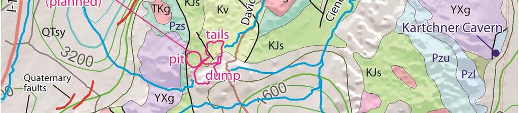
7 Figure 2. Geologic map of the Rosemont mine area showing outline of proposed open pit mine and distribute of map units. Paleozoic map units are labeled. The Escabrosa, Horquilla, Colina, and Concha limestone units contain less siliceous material and are more likely to be sites of dissolution. TKp: quartzfeldspar porphyry. Tg: Gila Conglomerate. Map data from Johnson and Ferguson (2007). Scale is indicated by section lines (red) that cross at one mile intervals, and UTM lines (gray) that cross at one kilometer intervals. Contour interval is 40 feet. Topographic base map is derived from the USGS Helvetia and Empire Ranch 7 ½ topographic quadrangle maps. 7
8 Figure 3. Topographic map of the Rosemont mine area showing primitive roads, prospect pits, adits, and shafts identified on the USGS Helvetia and Empire Ranch 7 ½ topographic quadrangle maps. Also shown are Devonian to Permian map units that include limestone units potentially susceptible to dissolution. Prospecting and mining activity, and road building, likely would have identified any open caves and, potentially, underground caves without surface openings. 8
9 Figure 4. Location of Cave of the Bells and Onyx Cave within the Sawmill Canyon shear zone. Fault slivers of Devonian to Permian carbonate and related units are shown in blue. Thick lines are faults. Groundwater movement is likely directed along the shear zone and not toward the Rosemont mine site. Geologic map from Drewes (1971). 9
Module 10: Resources and Virginia Geology Topic 4 Content: Virginia Geology Notes
 Virginia is composed of a very diverse landscape that extends from the beaches and barrier islands all of the way to the highly elevated Appalachian Plateau. Geologists have discovered ancient shallow
Tucson Geologic History: Cenozoic ( Ma (million years ago)) Dr. Jan C. Rasmussen
) Dr. Jan C. Rasmussen") Tucson Geologic History: Cenozoic (65.5 0 Ma (million years ago)) Dr. Jan C. Rasmussen www.janrasmussen.com Temp. & Geologic Time Scale 4.6 Ga Tertiary 65-0 Ma Orogenies (mountain building) Cenozoic Formations
Tucson Geologic History: Cenozoic (65.5 0 Ma (million years ago)) Dr. Jan C. Rasmussen www.janrasmussen.com Temp. & Geologic Time Scale 4.6 Ga Tertiary 65-0 Ma Orogenies (mountain building) Cenozoic Formations
Florida s Karst Geology
 Florida s Karst Geology Orange Creek Basin Interagency Working Group Public Workshop, November 5 th, 2015 Harley Means, P.G. Assistant State Geologist Florida Geological Survey Karst Karst a type of topography
NOA ASSESSMENT HARRIS QUARRY MENDOCINO COUNTY, CALIFORNIA TABLE OF CONTENTS
 NOA ASSESSMENT HARRIS QUARRY MENDOCINO COUNTY, CALIFORNIA TABLE OF CONTENTS Introduction... 1 Scope of Services... 1 Project Location and Description... 1 Geologic Setting... 1 Regional Geology... 1 Site
Weathering, Mass Wasting and Karst
 Weathering, Mass Wasting and Karst Capable of wearing down anything that the internal processes can build. Gravity, water, wind and ice Denudation - the overall effect of disintegration, wearing away and
RESISTIVITY IMAGING IN EASTERN NEVADA USING THE AUDIOMAGNETOTELLURIC METHOD FOR HYDROGEOLOGIC FRAMEWORK STUDIES. Abstract.
 RESISTIVITY IMAGING IN EASTERN NEVADA USING THE AUDIOMAGNETOTELLURIC METHOD FOR HYDROGEOLOGIC FRAMEWORK STUDIES Darcy K. McPhee, U.S. Geological Survey, Menlo Park, CA Louise Pellerin, Green Engineering,
Essentials of Geology, 11e
 Essentials of Geology, 11e Groundwater Chapter 10 Instructor Jennifer Barson Spokane Falls Community College Geology 101 Stanley Hatfield Southwestern Illinois Co Jennifer Cole Northeastern University
Chapter 14. Groundwater
 Chapter 14 Groundwater Importance of groundwater! Groundwater is water found in the pores of soil and sediment, plus narrow fractures in bedrock! Groundwater is the largest reservoir of fresh water that
Groundwater Resources of Missouri. Cynthia Brookshire, R. G.
 Groundwater Resources of Missouri Cynthia Brookshire, R. G. GROUNDWATER... Water beneath the Earth s surface within a zone of saturation AQUIFER... A geologic formation or group of formations that are
Overview of Selected Shale Plays in New Mexico*
 Overview of Selected Shale Plays in New Mexico* Ron Broadhead 1 Search and Discovery Article #10627 (2014)** Posted August 18, 2014 *Adapted from presentation at RMAG luncheon meeting, Denver, Colorado,
GPR AS A COST EFFECTIVE BEDROCK MAPPING TOOL FOR LARGE AREAS. Abstract
 GPR AS A COST EFFECTIVE BEDROCK MAPPING TOOL FOR LARGE AREAS Dr. Jutta L. Hager, Hager GeoScience, Inc., Waltham, MA Mario Carnevale, Hager GeoScience, Inc., Waltham, MA Abstract Hager GeoScience, Inc.
SOUTHWEST & NORTHWEST EXPLORATION PROJECTS BINGHAM CANYON MINING DISTRICT
 SOUTHWEST & NORTHWEST EXPLORATION PROJECTS BINGHAM CANYON MINING DISTRICT SALT LAKE AND TOOELE COUNTIES, UTAH SUMMARY FRIDAY, MARCH 20, 2009 1 Tooele County Salt Lake County GOOGLE EARTH September, 2006
Aeromagnetic map of the Death Valley ground-water model area, Nevada and California
 Aeromagnetic map of the Death Valley ground-water model area, Nevada and California By D.A. Ponce and R.J. Blakely Prepared in cooperation with the Nevada Operations Office National Nuclear Security Administration
Amador Canyon Silver Mining Property Lander County, NV
 Amador Canyon Silver Mining Property Lander County, NV Over $1 million worth of exploration and evaluation work performed Favorable drill results including a return of 286 g/ton silver over 12.2 meters
The Geology of Sebago Lake State Park
 Maine Geologic Facts and Localities September, 2002 43 55 17.46 N, 70 34 13.07 W Text by Robert Johnston, Department of Agriculture, Conservation & Forestry 1 Map by Robert Johnston Introduction Sebago
Amboy Iron Mines, Bristol Mountains, San Bernardino County, California. Gregg Wilkerson 2017
 Amboy Iron Mines, Bristol Mountains, San Bernardino County, California Gregg Wilkerson 2017 Acknowledgement and Disclaimer The information in this paper is taken largely from published sources. I have
Ecoregions Glossary. 7.8B: Changes To Texas Land Earth and Space
 Ecoregions Glossary Ecoregions The term ecoregions was developed by combining the terms ecology and region. Ecology is the study of the interrelationship of organisms and their environments. The term,
GLG101: What-To-Know List
 Exam 3, Page 1 GLG101: What-To-Know List (Derived from Before You Leave This Page Lists) This list is intended to guide your reading and to help you prepare for the online multiple-choice quizzes. Each
The Geology of Two Lights State Park. Cape Elizabeth, Maine
 Maine Geologic Facts and Localities June, 2002 Cape Elizabeth, Maine 43 33 33.48 N, 70 12 13.32 W Text by Henry N. Berry IV and Robert G. Marvinney, Department of Agriculture, Conservation & Forestry 1
Test is over no later than 9:40 p.m. There are 43 questions. Each is worth points, for a total of 100 points.
 Student name NOTE: Test 2 - Form B 3370:133 Section 001 SAMPLE Caves Count pages to make sure that you have all of them. Turn in this question sheet when done. Fill in all information requested on the
APPENDIX B SAMPLE ADEQUACY EVALUATION FOR ROSEMONT GEOLOGIC MATERIALS
 APPENDIX B SAMPLE ADEQUACY EVALUATION FOR ROSEMONT GEOLOGIC MATERIALS B1. INTRODUCTION An open pit copper mine and ore processing operation are planned for the Rosemont Copper Project (Rosemont) site,
The subject paper is being submitted for approval for publication in the annual volume entitled Geological Survey Research.
 Water Resources Division 345 Middlefield Road Menlo Park, California January 12, 1965 Memorandum To: Mr. Frank E. Clark, Chief, General Hydrology Branch Thru: Area Hydrologist PCA From: Valmore C. LaMarche
For personal use only
 22 April 2013 Drilling to commence at Majada, Copper-Gold Prospect, Chile. Red Gum Resources Limited (ASX: RGX, Red Gum or the Company ) is pleased to announce that drilling of its Majada Copper-Gold Prospect,
Seismic Reflection Imaging across the Johnson Ranch, Valley County, Idaho
 Seismic Reflection Imaging across the Johnson Ranch, Valley County, Idaho Report Prepared for the Skyline Corporation Lee M. Liberty Center for Geophysical Investigation of the Shallow Subsurface (CGISS)
Groundwater. (x 1000 km 3 /y) Reservoirs. Oceans Cover >70% of Surface. Groundwater and the. Hydrologic Cycle
 Reservoirs. Oceans Cover >70% of Surface. Groundwater and the. Hydrologic Cycle") Chapter 13 Oceans Cover >70% of Surface Groundwater and the Hydrologic Cycle Oceans are only 0.025% of Mass Groundwater Groundwater is liquid water that lies in the subsurface in fractures in rocks and
Chapter 13 Oceans Cover >70% of Surface Groundwater and the Hydrologic Cycle Oceans are only 0.025% of Mass Groundwater Groundwater is liquid water that lies in the subsurface in fractures in rocks and
Geology 101 Lab Worksheet: Topographic Maps
 Geology 101 Lab Worksheet: Topographic Maps Name: Refer to the Topographic Maps Lab for the information you need to complete this worksheet (http://commons.wvc.edu/rdawes/g101ocl/labs/topomapslab.html).
Geology 103 Planet Earth (QR II), Laboratory Exercises 1. Groundwater
, Laboratory Exercises 1. Groundwater") Geology 103 Planet Earth (QR II), Laboratory Exercises 1 Student Name: Section: Karst Landform: Groundwater Anyone who has viewed Chinese landscape scroll paintings will recognize that the mountains are
Geology 103 Planet Earth (QR II), Laboratory Exercises 1 Student Name: Section: Karst Landform: Groundwater Anyone who has viewed Chinese landscape scroll paintings will recognize that the mountains are
Page One. GEOL 1030 Pre test S15. Please enter your rst and last name.
 GEOL 1030 Pre test S15 Page One Please enter your rst and last name. First Name: Last Name: 1. The most common elements in the Earth's crust, in order of decreasing abundance, are: a. feldspar, quartz,
* **
 MT. BULGA REVISITED Bob Whiteley* and Tak Ming Leung** * rjwhiteley@optusnet.com.au ** tak-ming_leung@rta.nsw.gov.au Mt Bulga is located near Orange, New South Wales some 260 km west of Sydney. The first
3. GEOLOGY. 3.1 Introduction. 3.2 Results and Discussion Regional Geology Surficial Geology Mine Study Area
 3. GEOLOGY 3.1 Introduction This chapter discusses the baseline study of the geology and mineralization characteristics of the mine study area. The study consolidates existing geological data and exploration
Subsidence is the sinking or collapse of a portion of the land surface. The movement involved in subsidence is essentially vertical; little or no
 1 Subsidence is the sinking or collapse of a portion of the land surface. The movement involved in subsidence is essentially vertical; little or no horizontal motion is involved. It may take the form of
VICTORIA COPPER MINE
 THE VICTORIA COPPER MINE Elko County, Nevada USA Chuck Berg 801.947.8308 chuck.berg@coldwellutah.com CONTENTS SUMMARY... 1 LOCATION AND PROPERTY DESCRIPTION... 1 HISTORY... 3 PRODUCTION AND RESERVES...
ALPHA GOLD PROJECT 1
 ALPHA GOLD PROJECT 1 Alpha Gold Project Over 1,000 acre property targeting the intersection of the 50 Moz Cortez Gold Trend and the regional scale Pine Valley Garden Valley anticline Anticlinal Crest preserved
SAGUARO AND AGAVE SURVEY: PROPOSED SANTA RITA ROAD WATERLINE FOR THE ROSEMONT PROJECT TABLE OF CONTENTS LIST OF FIGURES
 SAGUARO AND AGAVE SURVEY: PROPOSED SANTA RITA ROAD WATERLINE FOR THE ROSEMONT PROJECT PREPARED FOR: PREPARED BY: Rosemont Copper Company WestLand Resources, Inc. DATE: February 3, 2010 PROJECT NO. 1049.14
Although most karstic regions
 Urban Geophysics: Geophysical Signature of Mount Bonnell Fault and Its Karstic Features in Austin, TX by Mustafa Saribudak, Environmental Geophysics Associates, Austin, TX Although most karstic regions
TERAS FLAGSHIP CAHUILLA PROJECT
 TERAS FLAGSHIP CAHUILLA PROJECT Cahuilla Company s Main Asset is located in mining friendly Imperial County, California. Mine Development Associates completed a NI 43-101 resource report; reporting an
Plan of Development Mountain Valley Pipeline Project. APPENDIX P Plan for Unanticipated Discovery of Paleontological Resources
 APPENDIX P Plan for Unanticipated Discovery of Paleontological Resources Appendix P Plan for Unanticipated Discovery of Paleontological Resources Prepared by: TABLE OF CONTENTS 1.0 INTRODUCTION... 1 1.1
GROUNDWATER PATHWAY MAPPING USING AIRBORNE GEOPHYSICS: TWO CASE STUDIES
 GROUNDWATER PATHWAY MAPPING USING AIRBORNE GEOPHYSICS: TWO CASE STUDIES Wayne Mandell 1, T. Jeffrey Gamey 2, William Doll 2 1 U.S. Army Environmental Center, Aberdeen Proving Ground, Maryland, 21010 (wayne.mandell@aec.apgea.army.mil)
Follow this and additional works at: Part of the Geology Commons
 Western Michigan University ScholarWorks at WMU Michigan Geological Repository for Research and Education Geosciences 2016 Geology of Michigan William B. Harrison III Michigan Geological Repository for
Wisconsin s Hydrogeology: an overview
 2012 Soil and Water Conservation Society Conference Stevens Point, WI Feb 9, 2012 Wisconsin s Hydrogeology: an overview Ken Bradbury Wisconsin Geological and Natural History Survey University of Wisconsin-Extension
Prof. Stephen A. Nelson EENS 111. Groundwater
 Page 1 of 8 Prof. Stephen A. Nelson EENS 111 Tulane University Physical Geology This page last updated on 20-Oct-2003 is water that exists in the pore spaces and fractures in rock and sediment beneath
New Mexico Geological Society
 New Mexico Geological Society Downloaded from: http://nmgs.nmt.edu/publications/guidebooks/26 Tectonic significance of the Pony Hills, Luna County, New Mexico LeRoy L. Corbitt and Fred L. Nials, 1975,
Unit 7.2 W.E.D. & Topography Test
 Name: Score: Unit 7.2 W.E.D. & Topography Test 1. 2. 3. 4. 5. 6. 7. 8. 9. 10. 11. 12. 13. 14. 15. 16. 17. 18. 19. 20. 21. 22. 23. 24. 25. 1. The formation of mountains is due mainly to while the destruction
Earth s Dynamic Surface
 Earth s Dynamic Surface Key Concepts What is the difference between physical and chemical weathering? How do water, ice, and wind change Earth s surface? Changing Earth s Surface What do you think? Read
Subsidence and Sinkholes
 4.3.11 Subsidence and Sinkholes This section provides a profile and vulnerability assessment for the subsidence and sinkhole hazard for the Armstrong County Hazard Mitigation Plan (HMP). Two common causes
Groundwater Resources of the Las Cruces/Doña Ana County Region
 Groundwater Resources of the Las Cruces/Doña Ana County Region Presentation to Lower Rio Grande Water Users Organization Water Symposium June 6, 2007 Las Cruces, NM by Bobby J. Creel, PhD New Mexico Water
Last Updated HYDROLOGIC ATLAS OF THE BLACK HILLS, PENNINGTON COUNTY, SOUTH DAKOTA
 Last Updated 10-29-2015 HYDROLOGIC ATLAS OF THE BLACK HILLS, PENNINGTON COUNTY, SOUTH DAKOTA INTRODUCTION The following is a brief outline of ground water characteristics in Pennington County, South Dakota.
KARST LANDSCAPES Geology & Hydrology. Dr. Gerald E. Weber
 KARST LANDSCAPES Geology & Hydrology Dr. Gerald E. Weber Aerial Oblique Photograph of the UCSC Campus looking northwest Karst A type of topography that is formed on limestone, gypsum, and other soluble
Case Study: University of Connecticut (UConn) Landfill
 Landfill") Case Study: University of Connecticut (UConn) Landfill Problem Statement:» Locate disposal trenches» Identify geologic features and distinguish them from leachate and locate preferential pathways in fractured
Case Study: University of Connecticut (UConn) Landfill Problem Statement:» Locate disposal trenches» Identify geologic features and distinguish them from leachate and locate preferential pathways in fractured
Karst found mostly in limestone (rock with at least 50% carbonate minerals), depends on 1) permeability & porosity
, depends on 1) permeability & porosity") KARST LANDFORMS produced by weathering & erosion in regions of carbonate rocks and evaporites processes called karstification mainly below ground surface predominantly underground drainage poorly-developed
KARST LANDFORMS produced by weathering & erosion in regions of carbonate rocks and evaporites processes called karstification mainly below ground surface predominantly underground drainage poorly-developed
Chapter 14: Groundwater. Fig 14.5b
 Chapter 14: Groundwater Fig 14.5b OBJECTIVES Recognize that groundwater is a vital source of accessible freshwater. Describe how groundwater forms below the water table. Explain the origin of aquifers,
ENVI.2030L Geologic Time
 Name ENVI.2030L Geologic Time I. Introduction There are two types of geologic time, relative and absolute. In the case of relative time geologic events are arranged in their order of occurrence. No attempt
Cretaceous, Dakota Formation, Terra Cotta Member South Side of I-70, Salina County, Kansas
 Cretaceous, Dakota Formation, Terra Cotta Member South Side of I-70, Salina County, Kansas Written By: Steven D.J. Baumann G-102010-1A Outcrop looking southeast Photo taken by: Steven Baumann on 10-20-2010
Mammoth Cave National Park, Kentucky
 Mammoth Cave National Park, Kentucky Objectives of Today s Lecture Refresher on Sedimentary Depositional Systems and Rock Classifications Transgressive and Regressive Marine Environments Carbonate Depositional
LOCATING AND CHARACTERIZING ABANDONED MINES USING MICROGRAVITY by Richard C. Benson 1, Ronald D. Kaufmann 1, Lynn Yuhr 1, Richard Hopkins 2 ABSTRACT
 LOCATING AND CHARACTERIZING ABANDONED MINES USING MICROGRAVITY by Richard C. Benson 1, Ronald D. Kaufmann 1, Lynn Yuhr 1, Richard Hopkins 2 ABSTRACT Surface geophysical methods can be an important part
a) Piedmont: e) Monument: f) Plateau: g) Mesa: h) Butte: i) Playa: j) Perennial Stream:
 Piedmont: e) Monument: f) Plateau: g) Mesa: h) Butte: i) Playa: j) Perennial Stream:") Name: Lab day: Tuesday Wednesday CEEES/SC 10110L-20110L Planet Earth Laboratory Laboratory #11: Arid Environments & Landforms Readings: See handout at http://www.nd.edu/~cneal/physicalgeo/lab-deserts/index.html.
Name: Lab day: Tuesday Wednesday CEEES/SC 10110L-20110L Planet Earth Laboratory Laboratory #11: Arid Environments & Landforms Readings: See handout at http://www.nd.edu/~cneal/physicalgeo/lab-deserts/index.html.
Virginia T. McLemore, New Mexico Bureau of Geology and Mineral Resources, New Mexico Institute of Mining and Technology, Socorro, NM 87801,
 Virginia T. McLemore, New Mexico Bureau of Geology and Mineral Resources, New Mexico Institute of Mining and Technology, Socorro, NM 87801, ginger@gis.nmt.edu U2011, Casper, Wy September 20, 2011 Acknowledgments
GEOLOGY (GEOL) Geology (GEOL) 1. GEOL 118 Societal Issues in Earth Science (4 crs)
 Geology (GEOL) 1. GEOL 118 Societal Issues in Earth Science (4 crs)") Geology (GEOL) 1 GEOLOGY (GEOL) GEOL 102 Oceanography (3 crs) Survey of the world oceans with emphasis on geologic processes. Also includes chemical, physical, and biological aspects of the sea. Investigates
Geology (GEOL) 1 GEOLOGY (GEOL) GEOL 102 Oceanography (3 crs) Survey of the world oceans with emphasis on geologic processes. Also includes chemical, physical, and biological aspects of the sea. Investigates
ENGINEERING EVALUATION OF THE STANLEY MINE ADVENTURE PARK AREA CLEAR CREEK COUNTY, COLORADO. Prepared for:
 braun Braun Consulting Engineers ENGINEERING EVALUATION OF THE STANLEY MINE ADVENTURE PARK AREA CLEAR CREEK COUNTY, COLORADO Prepared for: STANLEY MINES ADENTURE PARK 3375 W. POWERS CIRCLE LITTLETON, COLORADO
POTENTIAL OF THE DONGWE COPPER GOLD PROJECT
 POTENTIAL OF THE DONGWE COPPER GOLD PROJECT By Nathan Sabao, P.Geo. September 2015 1 TABLE OF CONTENTS Page 1.0 EXECUTIVE SUMMARY 1 2.0 LOCATION 2 3.0 ACCESS 2 4.0 GEOLOGY 3 5.0 PREVIOUS DRILLING 5 6.0
BIOGEOCHEMISTRY Discovery Using Metal Concentrations in Plants
 1 BIOGEOCHEMISTRY Discovery Using Metal Concentrations in Plants Shea Clark Smith Minerals Exploration & Environmental Geochemistry P.O. Box 18325 Reno, Nevada 89511 Tel: 775-849-2235 Fax: 775-849-2335
PRECAMBRIAN CRYSTALLINE AQUIFER (METAMORPHIC ROCKS)
") HAYWARD QUADRANGLE: Groundwater Production by Aquifer In the 56-square-mile area of the Hayward Quadrangle, groundwater is produced from metamorphic crystalline rocks of the Precambrian basement (in the
HAYWARD QUADRANGLE: Groundwater Production by Aquifer In the 56-square-mile area of the Hayward Quadrangle, groundwater is produced from metamorphic crystalline rocks of the Precambrian basement (in the
Wind Mountain Project Summary Memo Feeder Program
 A Manex Resource Group Company Wind Mountain Project Summary Memo Feeder Program J.A. Kizis, Jr., February 07, 2018 Assays have been received for both holes drilled at Wind Mountain during late 2017 and
KEMESS SOUTH MAGNETIC MODELING. CONDOR CONSULTING, INC. OCTOBER 2017
 KEMESS SOUTH MAGNETIC MODELING. CONDOR CONSULTING, INC. OCTOBER 2017 INTRODUCTION Magnetic data in the vicinity of the Kemess South Mine in the Yukon has been analyzed and modeled in order to try to explain
OIL AND GAS PLAYS OF THE MICHIGAN BASIN, SOUTHERN ONTARIO. Terry Carter, Consulting Geologist London, Ontario
 OIL AND GAS PLAYS OF THE MICHIGAN BASIN, SOUTHERN ONTARIO Terry Carter, Consulting Geologist London, Ontario 1 Ontario Petroleum Industries Oil and Natural Gas 1250 oil wells, 1200 gas wells, annual production
Structural Geology Lab. The Objectives are to gain experience
 Geology 2 Structural Geology Lab The Objectives are to gain experience 1. Drawing cross sections from information given on geologic maps. 2. Recognizing folds and naming their parts on stereoscopic air
Bog Hot Valley. (updated 2012)
") Bog Hot Valley (updated 2012) Geologic setting: Bog Hot Valley is located along a major fault lineament between Soldier Meadows Hot Springs and Oregon (figure; Hose and Taylor, 1974). This lineament can
Bog Hot Valley (updated 2012) Geologic setting: Bog Hot Valley is located along a major fault lineament between Soldier Meadows Hot Springs and Oregon (figure; Hose and Taylor, 1974). This lineament can
Soils, Hydrogeology, and Aquifer Properties. Philip B. Bedient 2006 Rice University
 Soils, Hydrogeology, and Aquifer Properties Philip B. Bedient 2006 Rice University Charbeneau, 2000. Basin Hydrologic Cycle Global Water Supply Distribution 3% of earth s water is fresh - 97% oceans 1%
Geological Mapping using Geophysics
 Geological Mapping using Geophysics Pugin, A.J.M. and T.H. Larson Illinois State Geological Survey, 615 E Peabody Dr., Champaign, IL 61820; E-mail: A.J.M. Pugin at pugin@isgs.uiuc.edu Mapping Techniques.
TOPOGRAPHIC RELIEF MAP of NYS. LANDFORMS of NYS. Landforms. Creation of NYS Landforms 9/22/2011
 TOPOGRAPHIC RELIEF MAP of NYS LANDFORMS of NYS Prof. Anthony Grande AFG 2011 Landforms The basis of present-day landforms (surface features) is the bedrock geology that has been worked on by the forces
Terrain Units PALEOGEOGRAPHY: LANDFORM CREATION. Present Geology of NYS. Detailed Geologic Map of NYS
 NYS TOPOGRAPHY Why so? PALEOGEOGRAPHY: LANDFORM CREATION Prof. Anthony Grande AFG 014 Present Geology of NYS Detailed Geologic Map of NYS Generalized Geology Detailed Geology Hot links to the fold out
Page 1. Name:
 Name: Questions 1 through 3 refer to the following: The diagrams below represent two rock outcrops found several miles apart in New York State. Individual rock layers are lettered, and fossils and rock
Geologic History of Texas: The Making of Texas Over 1.5 Billion Years
 # 4 Geologic History of Texas: The Making of Texas Over 1.5 Billion Years Dr. Richard Kyle March 24, 2000 Produced by and for Hot Science - Cool Talks by the Environmental Science Institute. We request
ASX Announcement/Media Release 11 April 2018
 20 Howard Street Perth WA 6000 PO Box Z5207 St George s Terrace ABN 66 138 145 114 Perth WA 6831 www.eonnrg.com Tel: 08 6144 0590 Fax: 08 6144 0593 ASX Code: E2E ASX Announcement/Media Release 11 April
General Geologic Setting and Seismicity of the FHWA Project Site in the New Madrid Seismic Zone
 General Geologic Setting and Seismicity of the FHWA Project Site in the New Madrid Seismic Zone David Hoffman University of Missouri Rolla Natural Hazards Mitigation Institute Civil, Architectural & Environmental
Chapter 13. Groundwater
 Chapter 13 Groundwater Introduction Groundwater is all subsurface water that completely fills the pores and other open spaces in rocks, sediments, and soil. Groundwater is responsible for forming beautiful
Groundwater. (x 1000 km 3 /y) Oceans Cover >70% of Surface. Groundwater and the. Hydrologic Cycle
 Oceans Cover >70% of Surface. Groundwater and the. Hydrologic Cycle") Chapter 17 Oceans Cover >70% of Surface Groundwater and the Hydrologic Cycle Vasey s Paradise, GCNP Oceans are only 0.025% of Mass Groundwater Groundwater is liquid water that lies in the subsurface in
Chapter 17 Oceans Cover >70% of Surface Groundwater and the Hydrologic Cycle Vasey s Paradise, GCNP Oceans are only 0.025% of Mass Groundwater Groundwater is liquid water that lies in the subsurface in
Structural Deformation and Karst in the Devonian Waterways Formation: Examples from Outcrops along the Athabasca River*
 Structural Deformation and Karst in the Devonian Waterways Formation: Examples from Outcrops along the Athabasca River* Chris L. Schneider 1 and Matthias Grobe 2 Search and Discovery Article #51073 (2015)
Section I: Multiple Choice Select the best answer to each question. Mark your final answer on the answer sheet. (1 pt each)
") Sedimentary Rocks & Surface Processes Quest Name: Earth Science 2013 Block: Date: Section I: Multiple Choice Select the best answer to each question. Mark your final answer on the answer sheet. (1 pt each)
Sedimentary Rocks & Surface Processes Quest Name: Earth Science 2013 Block: Date: Section I: Multiple Choice Select the best answer to each question. Mark your final answer on the answer sheet. (1 pt each)
FRACTURE TRACES AND PRODUCTIVITY OF MUNICIPAL WELLS IN THE MADISON LIMESTONE, RAPID CITY, SOUTH DAKOTA
 Proceedings of the South Dakota Academy of Science, Vol. 87 (2008) 261 FRACTURE TRACES AND PRODUCTIVITY OF MUNICIPAL WELLS IN THE MADISON LIMESTONE, RAPID CITY, SOUTH DAKOTA Perry H. Rahn Department of
B. T. Brady, M. S. Bedinger, John Mikels, William H. Langer, and Deborah A. Mulvihill
 DEPARTMENT OF THE INTERIOR UNITED STATES GEOLOGICAL SURVEY TO ACCOMPANY WRI REPORT 83-4121-B MAP SHOWING GROUND-WATER LEVELS, SPRINGS. AND DEPTH TO GROUND WATER, BASIN AND RANGE PROVINCE, TEXAS by B. T.
About Earth Materials
 Grotzinger Jordan Understanding Earth Sixth Edition Chapter 3: EARTH MATERIALS Minerals and Rocks 2011 by W. H. Freeman and Company About Earth Materials All Earth materials are composed of atoms bound
Harvey Thorleifson, Director, Minnesota Geological Survey. Status of geological mapping needed for groundwater protection in Minnesota
 Harvey Thorleifson, Director, Minnesota Geological Survey Status of geological mapping needed for groundwater protection in Minnesota Minnesota is located between the Dakotas and Wisconsin, north of Iowa,
Geology (Mellow) Hike, Santa Lucia Memorial Park February 16, I. Overview of Santa Lucia Range geology and tectonic history
 Hike, Santa Lucia Memorial Park February 16, I. Overview of Santa Lucia Range geology and tectonic history") Geology (Mellow) Hike, Santa Lucia Memorial Park February 16, 2015 I. Overview of Santa Lucia Range geology and tectonic history A. Basement Rocks 1. Salinian Block Rocks Sierra Nevada Type, continental
Geology (Mellow) Hike, Santa Lucia Memorial Park February 16, 2015 I. Overview of Santa Lucia Range geology and tectonic history A. Basement Rocks 1. Salinian Block Rocks Sierra Nevada Type, continental
Applied Geophysics for Environmental Site Characterization and Remediation
 Applied Geophysics for Environmental Site Characterization and Remediation MSECA Webinar September 24, 2015 John Mundell, P.E., L.P.G. Ryan Brumbaugh, L.P.G. MUNDELL & ASSOCIATES, INC. Webinar Objective
From Punchbowl to Panum: Long Valley Volcanism and the Mono-Inyo Crater Chain
 From Punchbowl to Panum: Leslie Schaffer E105 2002 Final Paper Long Valley Volcanism and the Mono-Inyo Crater Chain Figure 1. After a sequence of earthquakes during the late 1970 s to the early 1980 s
Chapter 7 Metamorphism, Metamorphic Rocks, and Hydrothermal Rocks
 Chapter 7 Metamorphism, Metamorphic Rocks, and Hydrothermal Rocks Copyright The McGraw-Hill Companies, Inc. Permission required for reproduction or display. Metamorphism What happens to rocks that are
UNDERSTANDING GEOLOGIC M APS
 Name: Lab Section: work in groups, but each person turns in his/her own GEOSCIENCE 001 L AB UNDERSTANDING GEOLOGIC M APS Geologic maps are colorful and even beautiful, but they also contain an amazing
J.H. Campbell Generating Facility Pond A - Location Restriction Certification Report
 J.H. Campbell Generating Facility Pond A - Location Restriction Certification Report Pursuant to: 40 CFR 257.60 40 CFR 257.61 40 CFR 257.62 40 CFR 257.63 40 CFR 257.64 Submitted to: Consumers Energy Company
STUDY GUIDE FOR MID-TERM EXAM KEY. Color, luster, cleavage, fracture, hardness, taste, smell, fluorescence, radioactivity, magnetism
 STUDY GUIDE FOR MID-TERM EXAM KEY 1. In which type of rock are fossils most likely to be found? Sedimentary Rocks 2. Which mineral is easily identified by smell? Sulfur 3. Which natural resource makes
2 Geology. 2.1 Elements of Terrane Analysis. Terrane or Terrain? Potential receptors
 2 Geology Knowledge of fractured rock geology, or terrane, provides important context for investigating contaminated sites. Tectonic forces impart characteristic structures on rock formations that influence
STUDY GUIDE FOR CONTENT MASTERY. Movement and Storage of Groundwater
 Groundwater SECTION 10.1 Movement and Storage of Groundwater In your textbook, read about the hydrosphere, precipitation and groundwater, and groundwater storage. Use the following terms to complete the
MESOZOIC BASINS. North Carolina Geological Survey
 MESOZOIC BASINS North Carolina Geological Survey The 1823 organic act which created the North Carolina Geological Survey (NCGS) tasked us to examine, describe and map the geology, geologic hazards, and
GEOLOGIC MAPS PART II
 EARTH AND ENVIRONMENT THROUGH TIME LABORATORY - EES 1005 LABORATORY FIVE GEOLOGIC MAPS PART II Introduction Geologic maps of orogenic belts are much more complex than maps of the stable interior. Just
Geophysical Exploration in Water Resources Assessment. John Mundell, P.E., L.P.G., P.G. Ryan Brumbaugh, L.P.G. Mundell & Associates, Inc.
 Geophysical Exploration in Water Resources Assessment John Mundell, P.E., L.P.G., P.G. Ryan Brumbaugh, L.P.G. Mundell & Associates, Inc. Presentation Objective Introduce the use of geophysical survey methods
Practice Test Rocks and Minerals. Name. Page 1
 Name Practice Test Rocks and Minerals 1. Which rock would be the best source of the mineral garnet? A) basalt B) limestone C) schist D) slate 2. Which mineral is mined for its iron content? A) hematite
A Geological Tour of Tumbledown Mountain, Maine
 Maine Geologic Facts and Localities April, 1998 A Geological Tour of Tumbledown Mountain, Maine 44 45 3.21 N, 70 32 50.24 W Text by Robert G. Marvinney, Department of Agriculture, Conservation & Forestry
Geological & Geophysical Interpretation of ZTEM EM and Magnetic Survey. Kemess Project, BC. for AuRico Metals Inc. September, 2016 Nicole Pendrigh
 Geological & Geophysical Interpretation of ZTEM EM and Magnetic Survey Kemess Project, BC for AuRico Metals Inc. September, 2016 Nicole Pendrigh SUMMARY REPORT Regional setting Located in North central
GEOL 110. Sedimentary Layering. Geologic Structures (faults, joints, folds), Unconformities, Karst. Sedimentary Layering 9/23/17. Geologic Structures
, Unconformities, Karst. Sedimentary Layering 9/23/17. Geologic Structures") GEOL 110 Sedimentary Layering Geologic Structures (faults, joints, folds), Unconformities, Karst Layering = horizontal, continuous banding produced during sediment deposition Sedimentary Layering Geologic
GEOL 110 Sedimentary Layering Geologic Structures (faults, joints, folds), Unconformities, Karst Layering = horizontal, continuous banding produced during sediment deposition Sedimentary Layering Geologic
9/23/2013. Introduction CHAPTER 7 SLOPE PROCESSES, LANDSLIDES, AND SUBSIDENCE. Case History: La Conchita Landslide
 Introduction CHAPTER 7 SLOPE PROCESSES, LANDSLIDES, AND SUBSIDENCE Landslide and other ground failures posting substantial damage and loss of life In U.S., average 25 50 deaths; damage more than $3.5 billion