RESULTS OF THE GEOPHYSICAL SURVEY WITHIN THE FRAMEWORK OF THE TIBREG PROJECT
|
|
|
- Chloe McKenzie
- 5 years ago
- Views:
Transcription
1 RESULTS OF THE GEOPHYSICAL SURVEY WITHIN THE FRAMEWORK OF THE TIBREG PROJECT M. PUCHNEROVÁ 1, J. ŠEFARA 2, V. SZALAIOVÁ 1, H. TKÁČOVÁ 1, J. GRETSCH 1, M. BIELIK 3, J. KISS 4, and S. KOVÁCSVÖLGYI 4 1 GEOCOMPLEX a. s. Bratislava, Slovakia 2 Comenius University, Faculty of Sciences Bratislava, Slovakia 3 Geophysical Institute of Slovak Academy of Sciences Bratislava, Slovakia 4 Eötvös Loránd Geophysical Institute of Hungary, Budapest Abstract : This paper shows the major results of geophysical study, performed within TIBREG project. They are based on interpretation of the gravity, magnetometry and vertical electric sounding surveys, using seismic and drilling data. New scheme of the pre-tertiary basement depths, scheme of the various types of neovolcanic structures, Quaternary thicknesses and updated stripped gravity map in relation to the basement structures are presented. Key words : TIBREG (Tisza-Bodrog Region) project, Transcarpathian basin, stripped gravity map, geometry and structure of basement, neovolcanics, Quaternary. Introduction The original extent of the TIBREG region (part of Slovakia, Hungary and Ukraine), necessary for unifying structural research, has been narrowed to Slovak Hungarian part only. All activities, with exception of the supplementary measurements of cca 300 VES stations for Quaternary thickness interpretation, have had re-interpretation character. For this purpose, the gravity and geomagnetic maps have been unified (on Slovak and Hungarian territory). On the basis of these maps, using seismic results Magyar et al., 1996) and density values from 21 boreholes the updating and analysis of geological phenomena have been performed (Puchnerová et al., 2001).
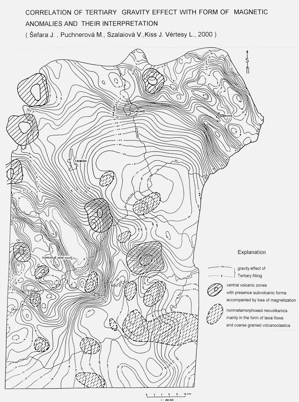
2 Interpretation methodology Besides Quaternary thicknesses interpretation by VES results, verified by VES parametric measurements at boreholes, following interpretation procedures and synthesa of geophysical data have been applied. In the area in question, the density analysis for Neogene (with exception of neovolcanics) and seismic results, based on borehole data in form of basement relief or other stratigraphic boundaries (Šefara et al., 2000) has been used (Fig. 1). Along four profile lines, the values of stripped gravity map have been established by determination of gravity effect of sedimentary basin. After original models, these values have been interpreted to the space (Fig. 2). By follow up substraction, further map, expressing gravity effect of Neogene on whole territory, has been compiled (Fig. 3). Moreover, the correlation of local gravity anomalies with geomagnetic map (Fig. 3) has been performed. From it, two basic structural types of neovolcanics have been established. First type is typical by expressive gravity anomaly and by usually to the ring oriented magnetic anomalies as a reflect of structure of the central volcanic zone with developped subvolcanic complex. Second structural type is characteristic by weak gravity effect and expressive magnetic anomalies as an effect of nonmetamorphosed volcanic complex of effusive character. The same synthesis has been applied for interpretation of anomaly sources in the basement. Major results of the project Quaternary structures On the basis of previous geophysical measurements and supplementary VES survey (Tkáčová in Puchnerová et al ), the first map of the Quaternary thicknesses has been compiled on Slovak territory. The Quaternary evolution of the studied area is divided after this map to the eight elevation and seven depression structures with maximum sediments thickness of 70 m. The largest is Bežovce depression of W-E coarse with continuation to the Ukraine.
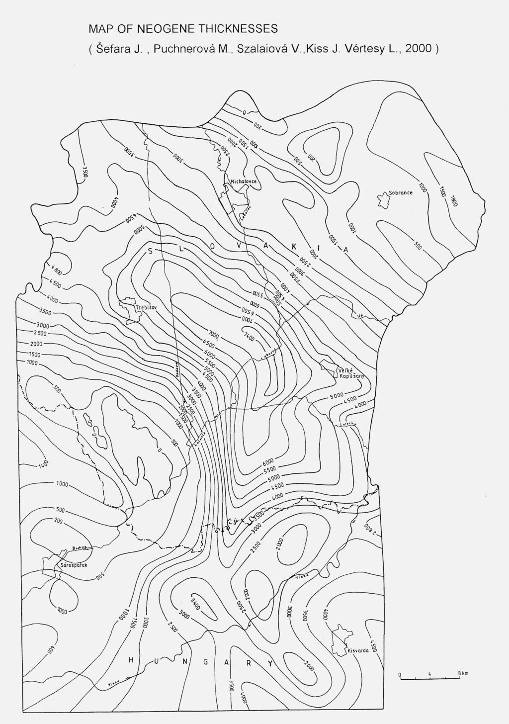
3 Neogene structures a) Map of Neogene thicknesses (Fig. 4) represents reinterpretation of original imaginations in part of area of interest (Magyar et al., 1996, Kováč 2000, etc), or on the whole region (Killenyi, Šefara et al., 1989). This map shows besides known structures predominantly Trebišov depression as a narrow and excentric one, with continuation of similar shapes to the sw. This expressive depression form divides Zemplín elevation from structures on Slovak Hungarian border zone (Seredniany ridge Rudinec, et al. 1981, Rudinec, 1989) with belated development of sediments. b) Neovolcanics forms They are divided to central volcanic zones and other ones (Fig.3). Besides central zones in the region limit (Slanské vrchy Mts., Vihorlat Mts.), similar forms have been defined at Brehov, Kráľovský Chlmec and two large forms on Hungarian side. The structure in surroundings of Streda nad Bodrogom is determined less convincingly. The rest of structures shows charasteristics of nonmetamorphosed lava flows. Basement structures They are mainly defined from boreholes only (for example Iňačovo Kričevo unit Sviridenko 1976). Besides it, Humenné, Ptrukša and Zemplin units are defined in the basement (Rudinec et al., 1981, Bielik,1998,etc.). In western part of the area the complexes of Čierna Hora Mts. (Rudinec 1989) are expected. On Hungarian territory, up to now nondefined unit takes place. The updated stripped gravity map (Fig. 2) brings more information about these units. In this map, besides central gravity elevation with probably relation to the Sečovce magnetic anomaly (Bielik et al., 1998), as of picture about deep structure, the relative minima of lower intensity with relation to the basement may be shown. In Slovak Hungarian border zone, the negative zone with relation to the envelope Zemplinicum (Upper Paleozoic to Mesozoic) take place. The negative gravity zone in n. part of studied area n. of Michalovce town) reflects zone with bed of highly magnetized body original suture. The negative zone s. of Byšta village is do not explained for lack of supporting data and, thus, this zone is probably less real. We cannot exclude here higher concentration of the Neogene sediments.
4 REFERENCES Bielik, M., Šefara, J., Soták, J., Bezák, V., Kubeš, P., 1998 : Deep structure of the Western and Eastern Carpathian junction. In Rakús (eds) : Geodynamic development of the Western Carpathians p Kilényi, E., Šefara, J., Kröll, A., Steinhauser, P., Weber, F., Obernauer, D., Rumpler, J., Szabo, Z., 1989: Pre Tertiary Basement Contour Map, of the Carpathian Basin beneath Austria, Czechoslovakia and Hungary. Scale 1: , ELGI Budapest, Geofyzika Brno, Bratislava Branch. Kováč, M., 2000 : Geodynamický, paleografický a štruktúrny vývoj karpatsko-panónskeho regiónu v miocéne : Nový pohľad na neogénne panvy Slovenska. Monografia, Veda, vydav. SAV, Bratislava, 202 str. Magyar, J., Mořkovský, M., Suchý, P., Jihlavec, F., Ostrolucký, P., 1996 : Neogene of Eastern Slovakia Geophysica II between years Archives of the Geological survey of Slovak Republic department of informatics Bratislava. Puchnerová, M., Baňacký, V., Elečko, M., Vass, D., Jetel, J., Kordík, J., Slaninka, I., Pramuka, S., Marsina, K., Čurlík, J., Grman, D., Cambel, B., Husák, Ľ., Viskup, J., Janotka, V., Hojnoš, M., Kandrík, M., Zeman, I., Szalaiová, V., Medo, S., Šefara, J., Rudinec, R., Tkáčová, H., Halmešová, S., Piovarči, M., Gretsch, J., 2001 : Research of natural sources with conection to environment in TIBREG (Tisza-Bodrog region). A) Geofactors of environment. Archives of the Geological survey of Slovak Republic Department of informatics, Bratislava, 140 p. Rudinec R., 1989 : Grude oil, natural gas and geothermal energy resources in Eastern Slovakia. Monograph Alfa, Bratislava p Rudinec, R., Tomek, Č., Jiříček, R., 1981: Sedimentary and structural Evolution of the Transcarpathian Depression. Earth evol. sci., 3-4, Wiesbaden, Sviridenko, V. G : Geologická stavba predneogénneho podložia Zakarpatskej prehľbeniny. Miner. Slov.,8, 5, p Šefara, J., Szalaiová, V., Puchnerová, M., Kovacsvölgyi, Alföldyová, A., Kiss, J., 2001 : Stripping of Gravity Field Based on the CDP Profiles in the Transcarpathians Basin and Interpretation of Density Magnetic Model Alpengravimetrie Kolloquim Leoben Austria, p
5
6
7
Key words: Moho, lithosphere, gravity modelling, reflection seismic transect, Western Carpathians,
 MULTIDISCIPLINARY GEOPHYSICAL AND GEOLOGICAL STUDY OF THE STRUCTURE AND DYNAMICS OF THE LITHOSPHERE IN THE WESTERN CARPATHIANS AND THE BOHEMIAN MASSIF JUNCTION J. ŠANTAVÝ, M. BIELIK 2 and J. VOZÁR 1 1
Bouguer anomaly map of Hungary
 GEOPHYSICAL TRANSACTIONS 2006 Vol. 45. No. 2. pp. 99 104 Bouguer anomaly map of Hungary János KISS * The Bouguer anomaly map of Hungary on a scale of 1:500,000 is given as Encloure 2. The main stages in
ENGINEERING GEOLOGICAL MAPS OF THE TIBREG REGION
 ENGINEERING GEOLOGICAL MAPS OF THE TIBREG REGION D. GRMAN 1, D. WANIEKOVÁ 1, Ľ. PETRO 2 and E. POLAŠČINOVÁ 2 1 Geokonzult a. s., Magnezitárska 7, 040 01 Košice, Slovakia 2 Geological Survey of Slovak Republic,
THE EAST SLOVAKIAN TRIPLE POINT JUNCTION AREA: COLLISIONAL PUZZLE OF THE WEST CARPATHIAN PANNONIAN EAST CARPATHIAN UNITS
 THE EAST SLOVAKIAN TRIPLE POINT JUNCTION AREA: COLLISIONAL PUZZLE OF THE WEST CARPATHIAN PANNONIAN EAST CARPATHIAN UNITS J. SOTÁK 1, A. VOZÁROVÁ 2 & J. VOZÁR 3 1 Geological Institute, Slovak Academy of
MAGNETIC ANOMALIES SOURCES OF THE TERTIARY AND QUATERNARY VOLCANISM OF THE WESTERN CARPATHIANS ON THE TERRITORY OF THE SLOVAK REPUBLIC
 MAGNETIC ANOMALIES SOURCES OF THE TERTIARY AND QUATERNARY VOLCANISM OF THE WESTERN CARPATHIANS ON THE TERRITORY OF THE SLOVAK REPUBLIC P. KUBEŠ, V. KONEČNÝ, M. FILO and L. ŠIMON GSSR Bratislava, Slovakia
GRAVITATIONAL SLOPE DEFORMATIONS IN GEOLOGICAL UNITS OF SLOVAKIA. MALGOT JOZEF and BALIAK FRANTIŠEK
 GRAVITATIONAL SLOPE DEFORMATIONS IN GEOLOGICAL UNITS OF SLOVAKIA MALGOT JOZEF and BALIAK FRANTIŠEK Department of Geotechnics Slovak University of Technology, Radlinského 11, 813 68 Bratislava Abstract:
University of Leeds 3GP Geophysics Field Trip Lake Balaton, Hungary
 University of Leeds 3GP Geophysics Field Trip Lake Balaton, Hungary September 1-15, 2007 geological background and logistics Staff: Greg Houseman, Graham Stuart The Alpine-Carpathian-Pannonian System Elevation
Determination of rock densities in the Carpathian-Pannonian Basin lithosphere: based on the CELEBRATION 2000 experiment
 Determination of rock densities in the Carpathian-Pannonian Basin lithosphere: based on the CELEBRATION 2000 experiment Barbora ŠIMONOVÁ1, Miroslav BIELIK 1,2 1 Department of Applied and Environmental
Deep geological structures as revealed by 3D gravity stripping: western part of the Moesian Platform, Romania
 JOURNAL OF BALKAN GEOPHYSICAL SOCIETY, Vol.8, No 3, August 2005, p.129-138 Deep geological structures as revealed by 3D gravity stripping: western part of the Moesian Platform, Romania D. Ioane*, C. Calota*,
We SRS1 11 3D Visualization of Miocene Tectonic Subsidence in the Northern and Central Vienna Basin Using BasinVis 1.0
 We SRS1 11 3D Visualization of Miocene Tectonic Subsidence in the Northern and Central Vienna Basin Using BasinVis 1.0 E.Y. Lee* (University of Vienna), J. Novotny (Brown University) & M. Wagreich (University
Thermal conditions for geothermal energy exploitation in the Transcarpathian depression and surrounding units
 Contributions to Geophysics and Geodesy Vol. 46/1, 2016 (33 49) Thermal conditions for geothermal energy exploitation in the Transcarpathian depression and surrounding units Dušan MAJCIN 1, Roman KUTAS
TECTONIC WEAK ZONES DETERMINED BY MAGNETOTELLURICS ALONG THE CEL-7 DEEP SEISMICS PROFILE
 Acta Geod. Geoph. Hung., Vol. 40(3 4), pp. 413 430 (2005) TECTONIC WEAK ZONES DETERMINED BY MAGNETOTELLURICS ALONG THE CEL-7 DEEP SEISMICS PROFILE A Ádám1,ANovák 1,LSzarka 1 [Manuscript received June 15,
TERRESTRIAL AND SHALLOW-MARINE DEPOSITS OF CENTRAL- CARPATHIAN PALEOGENE BASIN: EXAMPLE FROM EASTERN SLOVAKIA J. JANOČKO
 TERRESTRIAL AND SHALLOW-MARINE DEPOSITS OF CENTRAL- CARPATHIAN PALEOGENE BASIN: EXAMPLE FROM EASTERN SLOVAKIA J. JANOČKO Geological Survey of Slovak Republic, Jesenského 8, 040 11 Košice, Slovakia Abstract:
QUANTITATIVE INTERPRETATION OF GRAVITY DATA IN THE VIENNA BASIN REGION BY MEANS OF THE QUASI SINGULAR POINTS METHOD
 QUANTITATIVE INTERPRETATION OF GRAVITY DATA IN THE VIENNA BASIN REGION BY MEANS OF THE QUASI SINGULAR POINTS METHOD I. S. ELISEEVA 1, W. SEIBERL 2, P. SLAPANSKY 2, R. PAŠTEKA 3, R. ARNDT 2 1 VNIIGeofizika
The lithic raw material sources and interregional human contacts in the Northern Carpathian regions: a research program
 Lithic Raw Materials Phenomena of the Stone Age 9th SKAM Workshop Brno, Czech Republic, October 8-11, 2012 The lithic raw material sources and interregional human contacts in the Northern Carpathian regions:
Relation between time variation of gravity field and vertical surface movements in the Pannonian basin
 Relation between time variation of gravity field and vertical surface movements in the Pannonian basin L. Völgyesi Department of Geodesy and Surveying Budapest University of Technology and Economics, H521
1. Geological setting
 NEOGENE VOLCANISM IN OAS MTS., EASTERN CARPATHIANS, ROMANIA M. KOVACS and A. FULOP North University, 62A, V. Babes street, 4800 Baia Mare, Romania Abstract: Oas Mts., the northernmost part of Neogene volcanic
Exploring for geothermal reservoirs using broadband 2-D MT and gravity in Hungary
 KMS Technologies KJT Enterprises Inc. An EMGS/RXT company Exploring for geothermal reservoirs using broadband 2-D MT and gravity in Hungary Tulinius, H., Adám, L., Halldórsdóttir, H.,Yu, G., Strack, K.
Pleistocene alteration of drainage network and diverse surface morphology forced by basement structure in the foreland of the Eastern Alps
 This study was carried out in the framework of a project sponsored by the Hungarian National Science Foundation (OTKA NK83400) and TÁMOP-4.2.2/B-10/1-2010-0030 Pleistocene alteration of drainage network
Seismic Reflection Imaging across the Johnson Ranch, Valley County, Idaho
 Seismic Reflection Imaging across the Johnson Ranch, Valley County, Idaho Report Prepared for the Skyline Corporation Lee M. Liberty Center for Geophysical Investigation of the Shallow Subsurface (CGISS)
Fault Tectonics of the NE Black Sea Shelf and Its Relevance to Hydrocarbon Potential*
 Fault Tectonics of the NE Black Sea Shelf and Its Relevance to Hydrocarbon Potential* V.I. Starostenko 1, B.L. Krupskyi 1, I.K. Pashkevich 1, O.M. Rusakov 1, I.B. Makarenko 1, R.I. Kutas 1, V.V Gladun
Geomagnetic ground survey in Slovakia for the epoch
 Contributions to Geophysics and Geodesy Vol. 39/3, 2009 (255 272) Geomagnetic ground survey in Slovakia for the 2007.5 epoch Peter DOLINSKÝ, Fridrich VALACH, Magdaléna VÁCZYOVÁ 1, Milan HVOŽDARA2 1 Geomagnetic
Airborne gravity gradiometer surveying of petroleum systems under Lake Tanganyika, Tanzania
 Airborne gravity gradiometer surveying of petroleum systems under Lake Tanganyika, Tanzania D. Roberts Beach Energy P. Roy Chowdhury CGG S. J. Lowe CGG A. N. Christensen CGG Outline Introduction Geology
Integrated Interpretation of Gravity, Magnetic & Seismic data for delineation of Basement Configuration in Sadiya Block, Upper Assam, India
 P-225 Integrated Interpretation of Gravity, Magnetic & Seismic data for delineation of Basement Summary G.K.Ghosh *, S.K.Basha, V.K. Kulshreshth Gravity and magnetic data were collected jointly by National
2-D potential field modeling across the Hawtmi and Wiahatya faults in search of geothermal resources within the Umatilla Indian Reservation
 2-D potential field modeling across the Hawtmi and Wiahatya faults in search of geothermal resources within the Umatilla Indian Reservation Grober, Benjamin L. 1 & Palmer, Zachary A. 1 1 U.S. Geological
Complex geophysical and geological study of the Balaton Highlands: inferences from magnetic and geoelectric surveys
 Complex geophysical and geological study of the Balaton Highlands: inferences from magnetic and geoelectric surveys Zsófia Zalai 1, Tamás Lukács 1, Balázs Soós 1, Attila Balázs 1,2, András Kovács 1, Virág
SEQUENCE STRATIGRAPHY OF THE COAL BEARING OTTNANGIAN (?) - KARPATHIAN SEDIMENT SERIES IN THE EAST BORSOD BASIN (N-HUNGARY)
 - KARPATHIAN SEDIMENT SERIES IN THE EAST BORSOD BASIN (N-HUNGARY)") SEQUENCE STRATIGRAPHY OF THE COAL BEARING OTTNANGIAN (?) - KARPATHIAN SEDIMENT SERIES IN THE EAST BORSOD BASIN (N-HUNGARY) Z. PÜSPÖKI, M. KOZÁK, L. VINCZE and R. MCINTOSH University of Debrecen, Department
SEQUENCE STRATIGRAPHY OF THE COAL BEARING OTTNANGIAN (?) - KARPATHIAN SEDIMENT SERIES IN THE EAST BORSOD BASIN (N-HUNGARY) Z. PÜSPÖKI, M. KOZÁK, L. VINCZE and R. MCINTOSH University of Debrecen, Department
Interpretation of Subsurface Geological Structure of Massepe Geothermal Area Using Resistivity Data
 Proceedings World Geothermal Congress 2010 Bali, Indonesia, 25-29 April 2010 Interpretation of Subsurface Geological Structure of Massepe Geothermal Area Using Resistivity Data Ahmad Zarkasyi and Yuanno
C5 Magnetic exploration methods data analysis techniques
 C5 Magnetic exploration methods data analysis techniques C5.1 Data processing and corrections After magnetic field data have been collected a number of corrections are applied to simplify the interpretation.
Exploring for geothermal reservoirs using broadband 2-D MT and gravity in Hungary
 KMS Technologies KJT Enterprises Inc. An EMGS/RXT company Exploring for geothermal reservoirs using broadband 2-D MT and gravity in Hungary Tulinius, H., Adám, L., Halldórsdóttir, H.,Yu, G., Strack, K.
Blind fault Configuration in Osaka, Japan based on 2D gravity inversion
 Blind fault Configuration in Osaka, Japan based on 2D gravity inversion N. Inoue & N. Kitada Geo-research Institute, Osaka, Japan K. Takemura Institute for Geothermal Sciences, Kyoto University, Beppu,
SOME TOPICS OF GEODYNAMIC EVOLUTION OF INNER WESTERN CARPATHIANS. Z. NÉMETH 1 and M. PUTIŠ 2
 SOME TOPICS OF GEODYNAMIC EVOLUTION OF INNER WESTERN CARPATHIANS Z. NÉMETH 1 and M. PUTIŠ 2 1 Geological Survey of Slovak Republic, Jesenského 8, 040 01 Košice, Slovakia; nemeth@gssr-ke.sk 2 Dpt. of Mineralogy
GRAVITY AND MAGNETIC SURVEY NECHAKO BASIN STUDY ACQUISITION AND PROCESSING PHASE
 GRAVITY AND MAGNETIC SURVEY NECHAKO BASIN STUDY ACQUISITION AND PROCESSING PHASE Report prepared for the B.C. Ministry of Energy and Mines Resource Development Division New Ventures Branch by Bemex Consulting
Theses of PhD dissertation. Determination of earthquake site effect parameters by geophysical methods
 University of West Hungary Theses of PhD dissertation Determination of earthquake site effect parameters by geophysical methods Péter Tildy Sopron 2016 Doctoral school: Kitaibel Pál Doctoral School of
Comparison of the isotope hydrogeological features of thermal and cold karstic waters in the Denizli Basin (Turkey) and Buda Thermal Karst (Hungary)
 and Buda Thermal Karst (Hungary)") ESIR 2011 Central European Geology, Vol. 54/1 2, pp. 115 119 (2011) DOI: 10.1556/CEuGeol.54.2011.1 2.11 Comparison of the isotope hydrogeological features of thermal and cold karstic waters in the Denizli
ESIR 2011 Central European Geology, Vol. 54/1 2, pp. 115 119 (2011) DOI: 10.1556/CEuGeol.54.2011.1 2.11 Comparison of the isotope hydrogeological features of thermal and cold karstic waters in the Denizli
Difference between geoid undulation and quasigeoid height in Hungary
 BOLLETTINO DI GEOFISICA TEORICA ED APPLICATA VOL. 40, N. 3-4, pp. 571-575; SEP.-DEC. 1999 Difference between geoid undulation and quasigeoid height in Hungary J. ÁDÁM Department of Geodesy, Technical University
NATURAL ENVIRONMENT. Geophysics
 NATURAL ENVIRONMENT Geophysics Geodynamics Alpine, Carpathian and Dinaric mountain belts surround the Pannonian (Carpathian) Basin, of Neogene through Quaternary in age. The Cenozoic evolution of the Alpine-Pannonian
Subglacial Control on Glacier Flow in Northern Greenland
 Subglacial Control on Glacier Flow in Northern Greenland Beáta Csathó (University at Buffalo, SUNY, Buffalo, NY), C.J. van der Veen (U. of Kansas, Lawrence, KS) Ralph van Frese and Tim Leftwich (The Ohio
Contributions to Geophysics and Geodesy Vol. 47/2, 2017 (81 94)
") Contributions to Geophysics and Geodesy Vol. 47/2, 2017 (81 94) High resolution Slovak Bouguer gravity anomaly map and its enhanced derivative transformations: new possibilities for interpretation of anomalous
Contributions to Geophysics and Geodesy Vol. 47/2, 2017 (81 94) High resolution Slovak Bouguer gravity anomaly map and its enhanced derivative transformations: new possibilities for interpretation of anomalous
QUALITATIVE INTERPRETATION OF POTENTIAL FIELD PROFILES: SOUTHERN NECHAKO BASIN
 QUALITATIVE INTERPRETATION OF POTENTIAL FIELD PROFILES: SOUTHERN NECHAKO BASIN By Melvyn E. Best Bemex Consulting International 5288 Cordova Bay Road Victoria, B.C. V8Y 2L4 KEYWORDS: potential fields,
Natural analogues of CO2 leakages from storage reservoirs in SE Poland
 Natural analogues of CO2 leakages from storage reservoirs in SE Poland Adam WÓJCICKI & Wojciech WOŁKOWICZ The Polish basin aquifers (z= 1km; Kotański, 1997) Geology of Poland IGME5000 Generalized geology
USING NUMERICAL MODELING FOR ASSESSMENT OF POLLUTION PROBABILITY OF DRINKING WATER RESOURCES IN BORJOMI REGION (SOUTHERN GEORGIA)
") USING NUMERICAL MODELING FOR ASSESSMENT OF POLLUTION PROBABILITY OF DRINKING WATER RESOURCES IN BORJOMI REGION (SOUTHERN GEORGIA) GEORGE I. MELIKADZE* Seismic Monitoring Centre of Ilia State University,
USING NUMERICAL MODELING FOR ASSESSMENT OF POLLUTION PROBABILITY OF DRINKING WATER RESOURCES IN BORJOMI REGION (SOUTHERN GEORGIA) GEORGE I. MELIKADZE* Seismic Monitoring Centre of Ilia State University,
Rock mechanics as a significant supplement for cross-section balancing (an example from the Pavlov Hills, Outer Western Carpathians, Czech Republic)
") Trabajos de Geología, Universidad de Oviedo, 30 : 140-144 (2010) Rock mechanics as a significant supplement for cross-section balancing (an example from the Pavlov Hills, Outer Western Carpathians, Czech
Trabajos de Geología, Universidad de Oviedo, 30 : 140-144 (2010) Rock mechanics as a significant supplement for cross-section balancing (an example from the Pavlov Hills, Outer Western Carpathians, Czech
3D Geometry of the Xade Complex inferred from Gravity and Magnetic Data
 Geophysical Case Histories 3D Geometry of the Xade Complex inferred from Gravity and Magnetic Data 1. British Geological Survey, Edinburgh, United Kingdom Paper 92 Pouliquen, G. [1], Key, R. [1] ABSTRACT
Petroleum geology framework, West Coast offshore region
 Petroleum geology framework, West Coast offshore region James W. Haggart* Geological Survey of Canada, Vancouver, BC jhaggart@nrcan.gc.ca James R. Dietrich Geological Survey of Canada, Calgary, AB and
Application of integrated geophysical modeling for determination of the continental lithospheric thermal structure in the eastern Carpathians
 TECTONICS, VOL. 25,, doi:10.1029/2005tc001883, 2006 Application of integrated geophysical modeling for determination of the continental lithospheric thermal structure in the eastern Carpathians Jana Dérerová,
The Herľany geyser a unique hydrogeological and geotouristic locality in Europe
 Geotourism 3 4 (38 39) 2014: 41 48 http://dx.doi.org/10.7494/geotour.2014.38-39.41 The Herľany geyser a unique hydrogeological and geotouristic locality in Europe Ľubomír Štrba Technical University of
Geothermal Drilling for Space Heating in the Town of Szentlőrinc in SW Hungary
 Proceedings World Geothermal Congress 2010 Bali, Indonesia, 25-29 April 2010 Geothermal Drilling for Space Heating in the Town of Szentlőrinc in SW Hungary Ingunn María Thorbergsóttir 1, Helga Tulinius
Available online Journal of Scientific and Engineering Research, 2016, 3(2):1-7. Research Article
:1-7. Research Article") Available online www.jsaer.com, 2016, 3(2):1-7 Research Article ISSN: 2394-2630 CODEN(USA): JSERBR Assessment of the Reliability of Magnetic Method to Delineate Geologic Features in a Basement Complex:
Available online www.jsaer.com, 2016, 3(2):1-7 Research Article ISSN: 2394-2630 CODEN(USA): JSERBR Assessment of the Reliability of Magnetic Method to Delineate Geologic Features in a Basement Complex:
Slobodan Kolbah 1. DELINEATION OF DEEP WATER-BODIES
 Deep Transboundary Water-Bodies: Exploration & Management in the Pannonian Basin of the Republic of Croatia UNESCO-IAH-UNEP Conference, Paris, Slobodan Kolbah INA Naftaplin Oil & Gas Exploration & Producing
Tectonic Movements in the Central Kyushu, Japan
 /-,**.. +0 - +0,, +0, +* Tectonic Movements in the Central Kyushu, Japan Keiji TAKEMURA Beppu Geothermal Res. Lab., Kyoto University Abstract The central part of Kyushu, Japan is a locus of active arc-volcanism
Integrated interpretation of multimodal geophysical data for exploration of geothermal resources Case study: Yamagawa geothermal field in Japan
 Integrated interpretation of multimodal geophysical data for exploration of geothermal resources Case study: Yamagawa geothermal field in Japan Masashi Endo*(TechnoImaging), Alex Gribenko (TechnoImaging
Horizontal gradient and band-pass filter of aeromagnetic data image the subsurface structure; Example from Esh El Mellaha Area, Gulf of Suez, Egypt.
 Horizontal gradient and band-pass filter of aeromagnetic data image the subsurface structure; Example from Esh El Mellaha Area, Gulf of Suez, Egypt. Essam Aboud 1, Serguei Goussev 2, Hassan Hassan 2, Suparno
27. SURVEY AT SITES 346, 347, 348, 349, AND 350 THE AREA OF THE JAN MAYEN RIDGE AND THE ICELANDIC PLATEAU
 27. SURVEY AT SITES 346, 347, 348, 349, AND 350 THE AREA OF THE JAN MAYEN RIDGE AND THE ICELANDIC PLATEAU M. Talwani, 1 G. Udintsev, 2 E. Mirlin, 2 Beresnev, 2 V.F. Kanayev, 2 M. Chapman, 1 G. Gronlie,
Geothermal exploration using MT and gravity techniques at Szentlõrinc area in Hungary
 KMS Technologies KJT Enterprises, Inc. An EMGS/RXT company Geothermal exploration using MT and gravity techniques at Szentlõrinc area in Hungary Yu, G., He, Z. X., Hu, Z. Z., Ϸorbergsdóttir, I. M., Strack,
Modern geodynamic model of the Arctic Ocean
 Modern geodynamic model of the Arctic Ocean O. Petrov, N. Sobolev, A. Morozov, G. Grikurov, S. Shokalsky, S. Kashubin, E. Petrov Vienna, April 2012 Atlas of Geological Maps of the Circumpolar Arctic Magnetic
PREPARATION OF A RESEARCH PILOT PROJECT ON CO 2 GEOLOGICAL STORAGE IN THE CZECH REPUBLIC (REPP-CO 2 )
") ZACHYTÁVÁNÍ A UKLÁDÁNÍ CO2 V PODMÍNKÁCH ČR SPOLUPRÁCE ČESKÉ REPUBLIKY A NORSKA Praha 8. 11. 2016 PREPARATION OF A RESEARCH PILOT PROJECT ON CO 2 GEOLOGICAL STORAGE IN THE CZECH REPUBLIC (REPP-CO 2 ) INPUT
ZACHYTÁVÁNÍ A UKLÁDÁNÍ CO2 V PODMÍNKÁCH ČR SPOLUPRÁCE ČESKÉ REPUBLIKY A NORSKA Praha 8. 11. 2016 PREPARATION OF A RESEARCH PILOT PROJECT ON CO 2 GEOLOGICAL STORAGE IN THE CZECH REPUBLIC (REPP-CO 2 ) INPUT
Overview of the Seismic Source Characterization for the Palo Verde Nuclear Generating Station
 Overview of the Seismic Source Characterization for the Palo Verde Nuclear Generating Station Scott Lindvall SSC TI Team Lead Palo Verde SSC SSHAC Level 3 Project Tuesday, March 19, 2013 1 Questions from
GJI Seismology. doi: /j X x. Accepted 2006 June 15. Received 2006 May 30; in original form 2005 May 13
 Geophys. J. Int. (2006) 167, 737 760 doi: 10.1111/j.1365-246X.2006.03104.x Crustal and upper mantle structure of the Western Carpathians from CELEBRATION 2000 profiles CEL01 and CEL04: seismic models and
OBS Park in Warsaw 2017 European OBS Technical Workshop Paris, France,
 OBS Park in Warsaw 2017 European OBS Technical Workshop Paris, France, 06-07.11.2017 Agenda The Team Collaboration The Legacy Our OBS BalTec KNIPAS Future plans Lessons learned The team Department of the
Belgian Geological data for deep geothermal Energy
 Belgian Geological data for deep geothermal Energy Estelle Petitclerc, Michiel Dusar Geological Survey of Belgium (GSB) Contact: estelle.petitclerc@naturalsciences.be Utrecht, January 24 th, 2012 Available
IMPLYING ON TECTONICS OF BOROD BASIN (NW PART OF APUSENI MOUNTAINS, ROMANIA) C. BALICA and M.-V. POPA
 C. BALICA and M.-V. POPA") IMPLYING ON TECTONICS OF BOROD BASIN (NW PART OF APUSENI MOUNTAINS, ROMANIA) C. BALICA and M.-V. POPA Babes-Bolyai University, Department of Geology, M. Kogalniceanu 1, 3400 Cluj Napoca, Romania balica@bioge.ubbcluj.ro;
IMPLYING ON TECTONICS OF BOROD BASIN (NW PART OF APUSENI MOUNTAINS, ROMANIA) C. BALICA and M.-V. POPA Babes-Bolyai University, Department of Geology, M. Kogalniceanu 1, 3400 Cluj Napoca, Romania balica@bioge.ubbcluj.ro;
The 2nd South Asain Geoscience Conference and Exhibition,GEOIndia2011, 12-14th Jan,2011,Gearter Noida,New Delhi,India
 Summary Jaisalmer basin of western Rajasthan: a gravity perspective K. Arora, K. Suman, M.M. Dixit and D. Sarkar The sedimentary basins of western Rajasthan constitute a part of the shelf zone of the Indus
Sasvári Tibor 1 and Kondela Julián. Introduction
 Structural and Tectonic Composition and Origins of the Magnesite Deposit within the Dúbravský Massif near Jelšava, based on studies at the 220 m elev. Level (Western Carpathians) Sasvári Tibor 1 and Kondela
OZ SEEBASE TM. Datasets. Digital Elevation Model
 Digital Elevation Model 10 Digital Elevation Models (DEM s) often show the youngest structures, and any active geological structures. They are widely used for neotectonic analysis. The composition of eroding
Preliminary probabilistic seismic hazard assessment for the Nuclear Power Plant Bohunice (Slovakia) site
 site") Preliminary probabilistic seismic hazard assessment for the Nuclear Power Plant Bohunice (Slovakia) site P. Labák, A. Bystrická & P. Moczo Geophysical Institute, Slovak Academy of Sciences, Dúbravská cesta
Preliminary probabilistic seismic hazard assessment for the Nuclear Power Plant Bohunice (Slovakia) site P. Labák, A. Bystrická & P. Moczo Geophysical Institute, Slovak Academy of Sciences, Dúbravská cesta
The crustal and upper-mantle geophysical signature of narrow continental rifts in the Pannonian basin
 Geophys. J. Int. (1998) 134, 157^171 The crustal and upper-mantle geophysical signature of narrow continental rifts in the Pannonian basin A. Aè da m 1 and M. Bielik 2 1 Geodetic and Geophysical Research
Geothermal evaluation in Hungary using integrated interpretation of well, seismic, and MT data
 KMS Technologies KJT Enterprises, Inc. An EMGS/RXT company Geothermal evaluation in Hungary using integrated interpretation of well, seismic, and MT data Tulinius, H.,Ϸorbergsdóttir, I. M., Ádám, L., Hu,
The estimation of errors in calculated terrain corrections in the Tatra Mountains
 Contributions to Geophysics and Geodesy Vol. 40/4, 2010 (323 350) The estimation of errors in calculated terrain corrections in the Tatra Mountains Pavol ZAHOREC 1,RomanPAŠTEKA 2,JurajPAPČO 3 1 Geophysical
What Forces Drive Plate Tectonics?
 What Forces Drive Plate Tectonics? The tectonic plates are moving, but with varying rates and directions. What hypotheses have been proposed to explain the plate motion? Convection Cells in the Mantle
Civilization exists by geologic consent, subject to change without notice William Durant
 89.325 Geology for Engineers Plate Tectonics Civilization exists by geologic consent, subject to change without notice William Durant Properties of the Planets Size Density Distance from sun Chemistry
P105 Particularities of Astrakhan Gas Field Deep Structure Resulting from Microseismic Sounding Technique Application
 P105 Particularities of Astrakhan Gas Field Deep Structure Resulting from Microseismic Sounding Technique Application A.V. Gorbatikov* (Institute of Physics of the Earth, Rus.Acad.Sci.), M.Y. Stepanova
GEOELECTRICAL INVESTIGATIONS OF MARINE INTRUSIONS ON THE ROMANIAN BLACK SEA SHORE
 GEOELECTRICAL INVESTIGATIONS OF MARINE INTRUSIONS ON THE ROMANIAN BLACK SEA SHORE P. GEORGESCU, D. IOANE, B.M. NICULESCU, F. CHITEA University of Bucharest, Department of Geophysics, 6 Traian Vuia Street,
Geological model of Lobodice undergroun d gas storage facility based on 3D seismic interpretation
 Contributions to Geophysics and Geodesy Vol. 46/2, 2016 (125 135) Geological model of Lobodice undergroun d gas storage facility based on 3D seismic interpretation Lukáš KOPAL 1,PavelČÍŽEK1,Ján MILIČKA2
RAWL1NSON RANGE- YOUNG RANGE AEROMAGNETIC RECONNAISSANCE SURVEY,
 /06 ( e. r0-6;./? NOE-LIERIDO cc COMMONWEALTH OF AUSTRALIA MY TO num DEPARTMENT OF NATIONAL DEVELOPackTM"" BUREAU OF MINERAL RESOURCES, GEOLOGY AND GEOPHYSICS RECORD No- 1961-137 RAWL1NSON RANGE- YOUNG
GEOPHYSICS GRAVITY DATA COVERAGE
 GEOPHYSICS DATA COVERAGE The Mudgee-Gulgong district lies within the Dubbo 1:250,000 sheet area. This area is now covered by high res_olution gravity, magnetic and radiometric data. The aeromagnetic and
SOEE3250/5675/5115 Inverse Theory Lecture 10; notes by G. Houseman
 SOEE3250/5675/5115 Inverse Theory Lecture 10; notes by G. Houseman Travel-time tomography Examples of regional lithospheric tomography CBP / SCP projects data acquisition: array / sources arrival time
Gravity-Magnetic & Magneto-Telluric surveys in Purnea Onland Basin, India - A case history.
 P-281 Gravity-Magnetic & Magneto-Telluric surveys in Purnea Onland Basin, India - A case history. Summary A.K. Roy, D.P. Paine*, S. Sett, and H.N. Bhattacharya, ONGC This paper describes a case history
Play fairway mapping in the Northeast Atlantic Margin Comparison between mature and immature basins. David Mudge, Joanne Cranswick
 Play fairway mapping in the Northeast Atlantic Margin Comparison between mature and immature basins David Mudge, Joanne Cranswick Contents Ternan North Sea Play fairway mapping Tertiary case study Northeast
For personal use only
 20 7 APRIL JANUARY 2017 2017 ASX ASX ANNOUNCEMENT QUEENSLAND EXPLORATION PROJECTS UPDATE Projects identified by Sasak through analysis of regional geophysics and geochemistry databases to target IOCG (Iron
GEOELEC Prospective for Geothermal Electricity in Europe
 GEOELEC Prospective for Geothermal Electricity in Europe 3 rd Regional Workshop Italy, France, Slovenia and the Balkans Philippe Calcagno Burkhard Sanner Chrystel Dezayes BRGM EGEC BRGM Milano, 05/12/2011
1-D Electrical Resistivity Survey For Groundwater In Ketu-Adie Owe, Ogun State, Nigeria.
 IOSR Journal of Applied Geology and Geophysics (IOSR-JAGG) e-issn: 2321 0990, p-issn: 2321 0982.Volume 3, Issue 5 Ver. I (Sep. - Oct. 2015), PP 75-82 www.iosrjournals.org 1-D Electrical Resistivity Survey
Material Database of reflection surveys in Japan and pattern of active faults in seismic reflection profile
 Bull. of Yamagata Univ., Nat. Sci., Vol.15, No.4, Feb. 2004 Material Database of reflection surveys in Japan and pattern of active faults in seismic reflection profile Yosuke NAKAMURA, Akiko HASEMI, Tomotsugu
Euler Deconvolution JAGST Vol. 15(1) 2013
 2013") Euler Deconvolution JAGST Vol. 15(1) 2013 2D-EULER DECONVOLUTION AND FORWARD MODELING OF GRAVITY DATA OF HOMA-HILLS GEOTHERMAL PROSPECT, KENYA A. Odek 1, A. B. Otieno 1, W. J. Ambusso 1 and J. G. Githiri
Euler Deconvolution JAGST Vol. 15(1) 2013 2D-EULER DECONVOLUTION AND FORWARD MODELING OF GRAVITY DATA OF HOMA-HILLS GEOTHERMAL PROSPECT, KENYA A. Odek 1, A. B. Otieno 1, W. J. Ambusso 1 and J. G. Githiri
Application of the RMT method
 Application of the RMT method Investigations of the landfill of industrial wastes by the RMT method The test site is the landfill of the coal ashes from power plants. The landfill was closed about 5 years
Geophysical Methods in Tracing Palaeozoic Suture Zones Within the Lithosphere of Uzbekistan. Nurtaev B.S. Institute of geology and geophysics AS RUz
 15-06-23_Nurtaev_ T1.2-O3 Geophysical Methods in Tracing Palaeozoic Suture Zones Within the Lithosphere of Uzbekistan Nurtaev B.S. Institute of geology and geophysics AS RUz The complexity of the region
The placement of the Trans-European Suture Zone on the Romanian territory by electromagnetic arguments
 Earth Planets Space, 51, 1073 1078, 1999 The placement of the Trans-European Suture Zone on the Romanian territory by electromagnetic arguments Maria Stănică, Dumitru Stănică, and Cornelia Marin-Furnică
Geophysical Journal International
 Geophysical Journal International Geophys. J. Int. (2010) 182, 1 10 doi: 10.1111/j.1365-246X.2010.04595.x The bright spot in the West Carpathian upper mantle: a trace of the Tertiary plate collision and
Geothermal Exploration in Eritrea
 Geothermal Exploration in Eritrea Short Course III on Exploration for Geothermal Resources November 2008, Naivasha, Kenya Ermias Yohannes Berhane Ermias_yohannes@yahoo.com Ministry of Energy and Mines
Continental Margin Geology of Korea : Review and constraints on the opening of the East Sea (Japan Sea)
") Continental Margin Geology of Korea : Review and constraints on the opening of the East Sea (Japan Sea) Han-Joon Kim Marine Satellite & Observation Tech. Korea Ocean Research and Development Institute
Continental Margin Geology of Korea : Review and constraints on the opening of the East Sea (Japan Sea) Han-Joon Kim Marine Satellite & Observation Tech. Korea Ocean Research and Development Institute
Integrated Geophysical Interpretation On The Groundwater Aquifer (At The North Western Part of Sinai, Egypt)
") Integrated Geophysical Interpretation On The Groundwater Aquifer (At The North Western Part of Sinai, Egypt) Sultan Awad Sultan Araffa 1, Hassan S. Sabet 2, Ahmed M, Al Dabour 3 1 National Research Institute
Integrated Geophysical Interpretation On The Groundwater Aquifer (At The North Western Part of Sinai, Egypt) Sultan Awad Sultan Araffa 1, Hassan S. Sabet 2, Ahmed M, Al Dabour 3 1 National Research Institute
Geothermal Exploration in Greece
 Geothermal Exploration in Greece D. Mendrinos, O.Polyzou and C. Karytsas Centre for Renewable Energy Sources Geothermal exploration in Greece Started in the 70 s by IGME, PPC for high enthalpy fields for
1D and 2D Inversion of the Magnetotelluric Data for Brine Bearing Structures Investigation
 1D and 2D Inversion of the Magnetotelluric Data for Brine Bearing Structures Investigation Behrooz Oskooi *, Isa Mansoori Kermanshahi * * Institute of Geophysics, University of Tehran, Tehran, Iran. boskooi@ut.ac.ir,
General Geologic Setting and Seismicity of the FHWA Project Site in the New Madrid Seismic Zone
 General Geologic Setting and Seismicity of the FHWA Project Site in the New Madrid Seismic Zone David Hoffman University of Missouri Rolla Natural Hazards Mitigation Institute Civil, Architectural & Environmental
COMPLETE EVALUATION OF LANDSLIDE ACTIVITY. Peter Wagner, Peter Pauditš
 COMPLETE EVALUATION OF LANDSLIDE ACTIVITY Peter Wagner, Peter Pauditš Geological Survey of Slovak Republic, Mlynská dolina 1, 817 04 Bratislava, Slovakia (wagner@gssr.sk, paudits@gssr.sk) Abstract: Slope
Conceptual model for non-volcanic geothermal resources - examples from Tohoku Japan
 Conceptual model for non-volcanic geothermal resources - examples from Tohoku Japan S. Tamanyu 1 and K. Sakaguchi 2 1, 2 Geological Survey of Japan, National Institute of Advanced Industrial Science and
GROUNDWATER OCCURRENCE IN KENYA
 GROUNDWATER OCCURRENCE IN KENYA Steven Okoth Owuor Ministry of Water and Sanitation Sunday, January 20, 2019 1 Geography INTRODUCTION The Republic of Kenya is located in East Africa The total area of the
Heat Flow in the Caspian Black Sea Region and its Tectonic Implications*
 Heat Flow in the Caspian Black Sea Region and its Tectonic Implications* R. I. Kutas 1 Search and Discovery Article #50400 (2011) Posted April 25, 2011 *Adapted from extended abstract prepared for presentation
MUHAMMAD S TAMANNAI, DOUGLAS WINSTONE, IAN DEIGHTON & PETER CONN, TGS Nopec Geological Products and Services, London, United Kingdom
 Geological and Geophysical Evaluation of Offshore Morondava Frontier Basin based on Satellite Gravity, Well and regional 2D Seismic Data Interpretation MUHAMMAD S TAMANNAI, DOUGLAS WINSTONE, IAN DEIGHTON
TRANSTHERMAL. Geothermal potential study at the trans-border region of Austria and Slovenia regarding thermal and hydrological aspects. Goetzl G.
 TRANSTHERMAL Geothermal potential study at the trans-border region of Austria and Slovenia regarding thermal and hydrological aspects www.blumau.com. Geological Survey of Austria IASPEI General Assembly