Accepted Manuscript. P. Reynolds, S. Holford, N. Schofield, A. Ross. S (17) DOI: /j.marpetgeo Reference: JMPG 3066
|
|
|
- Allan Golden
- 5 years ago
- Views:
Transcription
30358-6 DOI: 10.1016/j.marpetgeo.2017.09.")
1 Accepted Manuscript The shallow depth emplacement of mafic intrusions on a magma-poor rifted margin: An example from the Bight Basin, Southern Australia P. Reynolds, S. Holford, N. Schofield, A. Ross PII: S (17) DOI: /j.marpetgeo Reference: JMPG 3066 To appear in: Marine and Petroleum Geology Received Date: 9 June 2017 Revised Date: 5 September 2017 Accepted Date: 8 September 2017 Please cite this article as: Reynolds, P., Holford, S., Schofield, N., Ross, A., The shallow depth emplacement of mafic intrusions on a magma-poor rifted margin: An example from the Bight Basin, Southern Australia, Marine and Petroleum Geology (2017), doi: /j.marpetgeo This is a PDF file of an unedited manuscript that has been accepted for publication. As a service to our customers we are providing this early version of the manuscript. The manuscript will undergo copyediting, typesetting, and review of the resulting proof before it is published in its final form. Please note that during the production process errors may be discovered which could affect the content, and all legal disclaimers that apply to the journal pertain.
2 1 2 3 The shallow depth emplacement of mafic intrusions on a magma-poor rifted margin: an example from the Bight Basin, southern Australia P. Reynolds 1*, S. Holford 1, N. Schofield 2, A. Ross Centre for Tectonics, Resources and Exploration (TRaX), Australian School of Petroleum, University of Adelaide, Adelaide, SA 5005, Australia 2 Department of Geology & Petroleum Geology, University of Aberdeen, Aberdeen AB24 3UE, UK 3 CSIRO Energy, Australian Resources Research Centre, 26 Dick Perry Avenue, Kensington, WA 6151, Australia *Corresponding author: peter.reynolds@adelaide.edu.au, Abstract Three-dimensional (3D) seismic data has provided important insights into how magma is transported and stored in sedimentary basins. Much of our understanding is based on volcanic-rifted margins. In contrast, the magma plumbing systems of magma-poor rifted margins are less well studied. This study uses 3D seismic data to describe the magma plumbing system of the Bight Basin Igneous Complex; a volcanic province located along the magma-poor southern Australian margin. Here, magma emplacement occurred in the Mid Eocene, some 40 million years after the onset of seafloor spreading. Our data images a variety of m thick, 2 23 km diameter mafic intrusions that are confined to within m of the paleoseabed. Intrusions emplaced at 200 m depth formed hybrid and compound sills and are typified by elongate, lava flow-like morphologies. Intrusions emplaced at depths of m formed saucer-shaped and compound sills, as well as 1
3 laccoliths. Approximately 60% of the intrusions have lava flows and volcanogenic vents above their shallowest tips, as shown from previous studies. This suggests that the intrusions played a crucial role in transporting magma to the paleoseabed. Furthermore, many of the intrusions are overlain by forced folds, highlighting the role of magma emplacement in inducing overburden deformation. Contrary to observations from volcanic rifted margins, the sills and laccoliths rarely form interlinked complexes. Instead, they most commonly occur as isolated bodies. This suggests that the sills and laccoliths were fed by dykes. We infer that high rates of magma ascent in the dykes prevented their transition into sills within sediments at >1.2 km depth. Our study highlights that the magma plumbing system of the Bight Basin Igneous Complex contains a diversity of magmatic intrusions, the morphology of which is linked to their emplacement depth, host sediment rheology and the physical properties of the magma. This plumbing system contrasts markedly with those found along better-studied volcanic rifted margins. 1. Introduction Sills and laccoliths play an important role in transporting and storing mafic magma in the shallow crust (Thomson, 2007; Muirhead et al., 2014; Magee et al., 2016). These features can form vertically and laterally connected complexes capable of facilitating magma movement for tens of kilometres through the crust (e.g. Thomson and Hutton, 2004; Planke et al., 2005; Cartwright and Hansen, 2006; Polteau et al., 2008; Schofield et al., 2015). From a volcanological perspective, sills and laccoliths are important because they can feed eruptions and modulate eruptive activity (e.g. Magee et al., 2013; Magee et al., 2016; Muirhead et al., ; Reynolds et al., 2016; Magee et al., 2017). As summarised by Magee et al. (2016), sills also provide insights into continental rifting, the thermomechanical state of the mantle and the physiochemical evolution of magma. Furthermore, mafic intrusions have been 2
4 hypothesised to play an important role in driving global climate change, since work from the North Atlantic has shown that the emplacement of mafic intrusions into carbon-rich sediments can cause the release of greenhouse gases (e.g. Svensen et al., 2004; Reynolds et al., 2017). Sills and laccoliths also have a range of implications for petroleum systems (e.g. Senger et al., 2017). For instance, these intrusions can act as barriers and/or conduits to fluid flow in the subsurface (e.g. Rateau et al., 2013; Schofield et al. 2015; Schofield et al. 2017) as well as hydrocarbon reservoirs (Rodriguez Monreal et al., 2009). Furthermore, magma intrusion is often associated with source rock maturation (Rodriguez Monreal et al., 2009) and the formation of forced folds (e.g. Pollard and Johnson, 1973; Jackson and Pollard, 1990; Trude et al., 2003; Schmiedel et al, 2017). These folds can be used to elucidate the timing of magmatism, as well as potentially acting as traps for hydrocarbons (Trude et al., 2003; Schutter 2003; Holford et al., 2012). Many observations of magma plumbing systems are from volcanic rifted margins which contain abundant mafic intrusions (e.g. Thomson and Hutton, 2004; Planke et al., 2005; Cartwright and Hansen, 2006; Schofield et al., 2015; Reynolds et al., 2017). However, since many of the intrusions along these margins are deeply buried, they often cannot be imaged at high resolution; partly as a result of decreasing seismic frequency with depth. Furthermore, many intrusions along volcanic rifted margins are located beneath thick sequences of extrusive volcanic rocks (e.g. Seaward Dipping Reflectors and Landward Flows) further obscuring intrusion distribution and morphology (e.g. Symonds et al., 1998; Planke et al., 2000; Reynolds et al., 2017). In contrast, there are comparatively few studies of the magma plumbing systems along magma-poor rifted margins (e.g. Autin et al., 2010; Franke et al., 2014; Peace et al., 2017). Therefore, our understanding of the emplacement mechanisms and controls on magma plumbing system formation along these margins is not well understood. 3
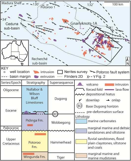
5 In this study, we use 3D seismic data from the magma-poor southern Australian margin. This data allows us to detail how magma was transported and stored in a sedimentary basin that has undergone volcanic activity not intrinsically linked to continental rifting. Our unique dataset images intrusions buried beneath a shallow (<2 km) sequence of sedimentary rocks. The shallow emplacement depth of the intrusions and absence of Seaward Dipping Reflections and Landward Flows (typical of volcanic rifted margins) also means our data is of high resolution, allowing the complexities of intrusion emplacement to be investigated in detail. Although focused on the southern Australian margin, our findings have implications for understanding the emplacement of magmatic intrusions in sedimentary basins along other continental rifted margins. 2. Geological setting The Ceduna sub-basin is located within the Bight Basin on the southern margin of Australia (Fig. 1). The sub-basin has an area of 90,000 km 2 and contains over 15 km of syn and post-rift Mesozoic sedimentary rocks (Totterdell and Krassay, 2003; MacDonald et al., 2010). These rocks are sub-divided into a series of supersequences that were deposited from the mid- to late-jurassic onwards. The earliest of these sequences record slow thermal subsidence, whilst the Late Santonian-aged Tiger Supersequence records increases in subsidence rate deposited the during major marine flooding (Totterdell et al., 2000). This supersequence is composed of marginal marine to marine mudstones (Totterdell et al., 2000). Deposition of these mudstones correlates with upper crustal extension and formation of large, east-west striking faults and re-activation of Cenomanian growth faults (Robson et al., 2016) The overlying Ceduna Delta succession was deposited from the Late Santonian onwards, and is composed of the Hammerhead Supersequence ( Totterdell et al., 2000; MacDonald et al., 2013). Component sedimentary rocks are characteristic of marine, deltaic and coastal 4
6 plain environments, and were deposited during extremely low spreading rates of <100 m year (Tikku and Cande, 1999). The Gnarlyknots-1A petroleum exploration well penetrated this supersequence and encountered water-saturated sandstones and shales, interpreted to form as shallow marine prograding delta top sets (Totterdell et al., 2000; Tapley et al., 2005). Both the Hammerhead and the overlying Wobbegong sequences (deposited following a 5 7 Myr hiatus) are dissected by northwest-southeast oriented Cenomanian-Santonian and Campanian-Maastrichtian-aged normal faults, formed during gravity-driven extension of the delta (Robson et al., 2016). The overlying Dugong Supersequence is dominated by cool water carbonates that developed on a carbonate shelf and contains minor amounts of sandstones at its base (Totterdell et al., 2000; Macdonald et al., 2012). This supersequence formed from the middle Eocene onwards during a period of fast seafloor spreading and records a marine transgression with water depths of up 300 m (Li et al., 2003). The southern margin of Australia is also characterised by an abundance of both offshore and onshore igneous rocks (e.g. Holford et al., 2012; Jackson, 2012; Cas et al., 2016; Meeuws et al., 2016; Reynolds et al., 2016). Melt production along the southern Australian margin has been proposed to result from processes similar to those in intraplate volcanic provinces, such as mantle shearing, mantle plumes and small scale convection above steps in lithospheric thickness (Demidjuk et al., 2007; Conrad et al., 2011; Davies et al., 2015). Subsequent volcanism may be associated with the onset of rapid spreading in the mid Eocene and reconfigurations of the Indo-Australian plate boundaries (Holford et al., 2012). The subject of this study is a 9000 km 2 area within the ~130 km diameter Bight Basin Igneous Complex (BBIC). This complex is found in the centre of the Ceduna sub-basin (Fig ). Previous work based on the Flinders 2D seismic survey has shown that the BBIC contains intrusions, lava flows, volcanogenic vents and forced folds (Schofield and Totterdell, 2008; Jackson et al., 2013; Magee et al., 2013). These features are described below. 5
7 Jackson et al. (2013) suggested that the intrusions range from 7 19 km in diameter and m in thickness. Their morphologies have previously been divided into sill, laccolith and hybrid types (Jackson et al., 2013). Intrusions are found within the Wobbegong, Hammerhead and Tiger Supersequences (Figs. 1 and 2; see also Schofield and Totterdell, 2008). Many of the intrusions are overlain by forced folds which reach 17 km in width and display up to 210 m of relief (Jackson et al., 2013). These folds are interpreted to have formed as a result of magma emplacement in the subsurface since they directly overly the intrusions. The folds typically have reliefs lower than the thickness of the underlying intrusion, suggesting fluidisation and expulsion of pore fluids from the host rock accompanied elastic bending of the overburden (Jackson et al., 2013). The Dugong Supersequence onlaps the folds, indicating the intrusions were emplaced in the Mid-Eocene (Schofield and Totterdell, 2008; Jackson et al., 2013; Magee et al., 2013). A total of 56 vents were identified by Magee et al. (2013). The vents downlap the top of the mid Eocene-aged Wobbegong Supersequence and are onlapped by the Dugong Supersequence (Schofield and Totterdell, 2008; Jackson et al., 2013; Magee et al., 2013). They typically overly the shallowest tips of underlying intrusions. The vents range from km in diameter, and have been interpreted as hydrothermal vents and shield volcanoes (Magee et al., 2013). The vents and volcanoes have been distinguished based on morphological characteristics such as their flank dip, summit height and seismic velocity. The spatial and temporal relationship between the vents and intrusions suggest that they are genetically linked (Magee et al., 2013). Dredging from incised canyons collected detrital volcanic fragments that were characterised as amygdaloidal, possibly pillowed, alkali basalts (Clarke and Alley, 1993) suggesting that the vents have a similar composition (Schofield and Totterdell, 2008; Magee et al., 2013). The vents occur on the same horizon as biogenic mounds, which are distinguished based on their lower lateral variation in seismic amplitude, 6
8 higher internal continuity, smaller heights and the absence of wash-out beneath (Langhi et al., 2016) Method and dataset This study uses the Nerites 3D and Flinders 2D seismic reflection surveys (Fig. 1). The Nerites survey covers an area of 9000 km 2 and extends to 9 s depth, of which the top 3 s were used in this study. This dataset has a bin spacing of 12.5 m 15 m. The Flinders survey covers 44,000 km 2 and also extends to 9 s depth. The 2D lines are spaced 4 8 km. Data are displayed with an SEG reverse polarity; a downward increase in acoustic impedance (i.e. hard event) is measured by a trough and is represented by a blue reflection. The seismic surveys are tied to the Gnarlyknots-1A and Potoroo-1 wells using the Flinders 2D seismic survey. The wells are located 65 km and 175 km to the northwest of the Nerites survey. Neither well penetrated the intrusions, therefore we assumed a velocity of 5500 m s -1 (Planke et al., 2005) to calculate their thicknesses. Although typical for many intrusions (e.g. Skogly, 1998; Hansen and Cartwright, 2006), this value represents a lower estimate for the velocity of the intrusions; Nelson et al. (2009) record values up to 7000 m s -1. The resolution and detection limit of the seismic data were calculated using a frequency of 30 Hz, which is the dominant frequency of the Nerites survey at the level at which the intrusions were mapped (between s). Assuming a velocity of 5500 m s -1, this indicates the intrusions must be 5 m to be detected and 45 m thick to be resolved. Based on the potential variation in their velocity (e.g. Nelson et al., 2009), these values likely represent the minimum thicknesses that can be detected and resolved Seismic interpretation strategy 7
9 In order to determine the vertical and lateral distribution of the intrusions, and their relationship to the lava flows, volcanogenic vents and paleoseabed, we mapped each of these features throughout the Nerites survey. Our interpretation strategy is outlined below Mapping of the paleoseabed The Base Dugong (BD) reflection represents the paleoseabed at the time of volcanism (Schofield and Totterdell, 2008; Jackson et al., 2013; Magee et al., 2013). It is represented by a moderate-high amplitude, trough event that forms a prominent unconformity that is onlapped by the overlying Dugong Supersequence. The BD is downlapped by the vents and is folded above underlying intrusions Mapping of volcanogenic vents and lava flows The tops of the volcanogenic vents are represented by the Top Vent (TV) reflection. This reflection varies from low to high amplitude and from a trough to peak event. It varies in character from smooth to rough and continuous to semi-continuous. The vents are onlapped by the overlying Dugong Supersequence which may be domed above the centre of the vent. In time slice the vents have a concentric structure which becomes more chaotic with depth. The bases of the vents are represented by the BD reflection and/or the top of an adjacent vent in cases where vents overlap. Seismic velocity pull-up and washout is common beneath the vents, particularly towards their centres (e.g. Schofield and Totterdell, 2008; Magee et al., 2013). Such features are typical of volcanic rocks in sedimentary sequences (e.g. Jerram, 2002) The tops of the lava flow fields are represented by the Top Extrusive (TE) reflection. This is represented by a high amplitude trough that is parallel to the underlying BD reflection. The 8
10 TE reflection is smooth, sub horizontal and terminates abruptly. Seismic velocity pull-up and zones of washout are common beneath the TE Mapping of intrusions We mapped the intrusions using the seismostratigraphic approach of Planke et al. (2000) and Planke et al. (2015). The top of the intrusions are represented by the Top Intrusion (TI) reflection. Intrusions can split into several units or merge, meaning that the TI reflection is located at multiple levels and is not laterally continuous. It is a high amplitude, trough event that cross-cuts adjacent reflections and has abrupt terminations. The Base Intrusion (BI) reflection is a moderate-high amplitude, peak event that also cross-cuts adjacent reflections and has abrupt terminations. In regions where the Base Intrusion reflection was not visible (i.e. the thickness of the intrusion is below the resolution limit of the data) the intrusion was represented by a single trough-peak doublet. In this case, we picked the peak event of the doublet as the Base Intrusion. 3.2 Calculating intrusion emplacement depth and volume The emplacement depth of the intrusions was calculated from the distance in milliseconds two-way time (TWT) between the TI reflection and the BD reflection. We converted from TWT to depth in metres using an interval velocity of 2100 m s -1, as indicated by the Gnarlyknots-1A well. For each intrusion we calculated a minimum and maximum volume from depth- converted grids of the Top Intrusion and Base Intrusion reflections. In the first instance, these calculations assume that the intrusions have a thickness equal to the seismic detection limit (5 m) in regions where the intrusion was represented by a single trough-peak doublet. Conversely, to calculate the maximum volumes, we assumed that the intrusions have a 9
11 thickness of 44 m (the maximum possible thickness below the resolution limit) in regions where the only a single trough-peak doublet was identified. Since the entire thicknesses of some intrusions are between the detection limit and resolution limit, they have a wide range in possible volumes (e.g. intrusion 1, Table 1). In contrast, other intrusions are >45 m in thickness across 90% of their areas, giving them a narrow volume range (e.g. intrusion 4, Table 1). 4. Description of the intrusions 4.1 Intrusion morphology Four morphologically-distinct types of intrusions are identified, including saucer-shaped, compound and hybrid sills, as well as laccoliths (Fig. 3). All intrusions occur m beneath the paleoseabed (not accounting for compaction) within the Tiger, Hammerhead and Wobbegong Supersequences (Fig. 4). These intrusions vary from 2 23 km in length, 1 18 km in width and m in thickness (Figs. 4 and 5). Their morphology is described below Saucer-shaped sills Saucer-shaped sills comprise half of all mapped intrusions. They have a sub-circular shape in plan view whilst in cross section they have a flat inner saucer and gently inclined, transgressive rims defined by sub-parallel TI and BI reflections (Fig. 3). The inner saucers form 60 70% of the sills diameter, whilst the rims make up the remaining 30 40%. These rims can transgress the host rocks by up to 225 m (e.g. intrusion 26; Fig. 3). The sills have volumes varying from km 3 (Table 1). Their thicknesses vary from m and 246 their thickest regions are found in the centre of the inner saucer (Fig. 5) Compound intrusions 10
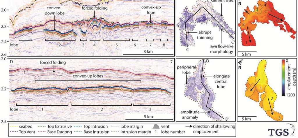
12 Compound intrusions constitute approximately 10% of the mapped intrusions. They are commonly elongate and have convex or concave, irregular-shaped margins in plan view (Fig. 3). Compound intrusions have volumes of < km³ (Table 1) and vary from m thick. The intrusions may have multiple regions >45 m thick (Fig. 5) and these regions commonly occur at the greatest depths (300 m). Seismic amplitude maps indicate that the compound intrusions are composed of multiple lobes which vary from elongate to saucershaped. This is typified by intrusion 31, which is composed of multiple lobes approximately 1 8 km in diameter (measured along their longest axis). These lobes have convex or concave margins and aspect ratios of 1 4. In cross section, the lobes have convex-up, convex-down or planar-shaped geometries defined by the TI reflection (Fig. 3). This reflection is paralleled by the BI reflection (Fig. 3) Hybrid Intrusions Hybrid intrusions account for approximately a third of the magmatic bodies in the Nerites survey. In plan view, the hybrid intrusions are typically elongate, and those emplaced at <200 m depth have sinuous, lava flow-like morphologies (e.g. intrusion 36; Fig. 3). Their volumes vary from km 3 (Table 1). The hybrid intrusions vary from m thick, and thin towards their distal margins (Fig. 5). The thickest regions occurring above their deepest parts. As for the compound intrusions, seismic amplitude maps indicate that these intrusions are composed of multiple lobes. Some lobes are sub-circular with transgressive rims (e.g. intrusion 20; Fig. 4) whilst others are more elongate (e.g. intrusion 36; Fig. 3). The longest axes of individual lobes vary from km in diameter, and they have aspect ratios of 1 8. The lobes shallow towards their distal margins. In cross section the lobes have convex-up or down shapes TI reflections which are paralleled by their BI reflections (Fig. 3). 11
13 Laccoliths The laccoliths represent 5% of the intrusions in the Nerites survey. In plan view the laccoliths are elongate. They have volumes varying from km 3 and thicknesses varying from m. The thickest parts of the laccoliths are found along their central axes (Fig. 5). Seismic amplitude maps indicate they are composed of a central, elongate lobe that bifurcates into a series of peripheral lobes that transgress the stratigraphy (Fig. 3). The lobes have convex-outwards margins. Measurements of the longest lobe axes indicate they vary from 1 13 km in length and they have aspect ratios of 1 4. The central lobes are the largest lobes. In cross section, individual lobes have a convex-upwards TI reflection and a subhorizontal BI reflection. The lobes have sinuous amplitude anomalies along their length that run parallel to the lobes longest axis (Fig. 3). These anomalies terminate abruptly at lobe junctions. 4.2 Intrusion distribution and connectivity The intrusions are concentrated in the inboard, central part of the Ceduna sub-basin above the Potoroo fault system (Fig. 1). The intrusions were emplaced at depths ranging from m, with the shallowest intrusions tending to be found basinward (Figs. 4 and 6). There appears to be no relationship between intrusion diameter and emplacement depth; large diameter intrusions can occur at all depths in the survey (Fig. 6). Saucer-shaped sills are found at the greatest depths of all the intrusion types, and occur m beneath the paleoseabed. Saucer-shaped sills >1 km 3 in size are only found at depths >500 m (e.g intrusions 6 and 12). The hybrid intrusions and compound intrusions are found at the shallowest depths of m and m respectively. These intrusions display no relationship between volume and emplacement depth (Fig. 6). Laccoliths are found at 12
14 m depth and they similarly do not display a volume-depth relationship. Many of the intrusions are overlain by forced folds (Schofield and Totterdell, 2008; Jackson et al., 2013; Magee et al., 2013). The outlines of these folds are similar to that of the underlying intrusion, and their amplitudes are equal-to or lower than the thickness of the underlying intrusion (Jackson et al., 2013). About 60% of the intrusions are not vertically or laterally connected to others, and occur as isolated features (e.g. intrusions H7 and H18; Fig. 7; Table 1). The remaining 40% of the intrusions form interlinked complexes. These complexes are composed of individual intrusions which overlap by as much as half of their diameter (e.g. Intrusions 12 and 24; Fig. 7). The complexes can extend laterally for 20 km and vertically for ~600 m. The intrusions do not offset each other, preventing deduction of the relative timing of intrusion emplacement. 4.3 Determining intrusion source regions The morphology of the intrusions and their component lobes are similar to those of other mafic intrusions identified from 3D seismic and well data (e.g. Planke et al., 2005; Schofield et al., 2012a; Schofield et al., 2015). We are able to use the morphology of the intrusions (e.g. bridge structures; see Schofield et al., 2012a) and their emplacement depths to infer the direction of magma flow. Mafic intrusions usually propagate from their deepest parts towards the paleosurface (see Galland et al., 2009; Schofield et al., 2010). Magma is also commonly transported from larger feeder lobes towards smaller lobes at the periphery of the intrusion (e.g. Schofield et al., 2012a; Suleiman et al., 2017). Based on these observations, we infer that the saucer-shaped sills were emplaced via flow of magma upwards and radially outwards from a source region found at their deepest points (e.g. Fig. 8; Malthe- Sørenssen et al., 2004; Galland et al., 2009). In comparison, the compound sills are 13
15 characterised by radial and unidirectional magma flow in their component lobes (Fig. 8). We suggest that these intrusions were constructed via the amalgamation of multiple lobes fed from multiple points, rather than by the feeding of one lobe to another, as within the saucer-shaped sills. Magma flow in the hybrid intrusions was strongly unidirectional in the elongate lobes, whilst was radial in their sub-circular lobes. Similar to the saucer-shaped sills, these intrusions have a source region located at their deepest point (Fig. 8). Within the laccoliths, the direction of magma flow appears to have been predominantly unidirectional from a source point at their greatest depth (Fig. 8). 4.4 The role of dykes in feeding the sills and laccoliths We interpret that many of the intrusions are fed by dykes (e.g. Fig. 9) since the sills and laccoliths most commonly occur as isolated features that do not form vertically connected complexes. Approximately half of the dykes are inferred to have propagated up both northdipping and south-dipping fault planes, supported by the location of approximately half of the intrusions source regions above fault planes (e.g. Fig. 8). The dykes intruded and were emplaced approximately perpendicular to the regional orientation of σ 3, as indicated by their orientation within east-west striking normal faults. We infer that the remaining half of the dykes propagated via host-rock fracturing at the dyke tip and did not exploit pre-existing faults. The possibility of the dykes exploiting faults within the wash out zones beneath the intrusions is excluded, since many faults have lengths of 50 km; greater than the diameters of overlying intrusions ( 23 km). The length of the dykes is unknown; dykes do not propagate to equal heights along their length (Keating et al., 2008). Our observations therefore complement those of other intraplate volcanic provinces, which suggest that dykes form the dominant mechanism of vertical magma transport (e.g. Brenna et al., 2011; van den Hove et al., 2017). 14
16 Relationship between intrusive and extrusive components of the magmatic system 5.1 The surface manifestation of volcanism The BBIC contains lava flow fields and volcanogenic vents that are most densely concentrated within the central part of the Nerites survey (Figs. 1 and 10). These features onlap onto the forced folds (Fig. 11). In our dataset, approximately 60% of the vents and lava flow fields are found directly above the tips of the sills and laccoliths (Fig. 12). The remaining extrusive features are either not underlain by intrusions (20% of those mapped; Fig. 10) or are found above the centres of compound intrusions (20% of those mapped; Fig. 10). 5.2 The role of intrusions in feeding surface volcanism A temporal link between the timing of intrusive and extrusive activity is evidenced by the extrusive features which onlap onto the forced folds caused by the intrusions, and the fact that the forced folds, vents and lava flows are all onlapped by the Dugong Supersequence (Figs. 11 and 12). The spatial relationship between the extrusive features and the shallowest, lateral terminations of intrusions (e.g. Fig. 12) leads us to suggest that the sills and laccoliths played an important role in feeding eruption sites and delivering magma to the paleoseabed, consistent with previous authors (Magee et al., 2013). Whilst we cannot prove that each individual extrusive feature was directly fed by the intrusion which it overlies, the intrusions which terminate within 100 m of the BD provide strong evidence that some vents and lava flow fields were fed by the underlying intrusion. Small dykes emanating from sill tips may have facilitated magma movement in the shallowest subsurface. Consistent with Magee et al. (2013) we infer that the tips of intrusions may not be imaged in contact with the base of the overlying vents because either: 1) the volcanoes were fed by dykes in the shallowest 15
17 hundreds of metres, and these dykes cannot be imaged in seismic data (e.g. Thomson, 2007); and/or 2) washout of seismic data beneath the volcanoes prevents us from imaging the shallowest tips of the intrusions It is interesting that some of the intrusions are not linked to any extrusive features (e.g. intrusion 37; Fig. 10). This suggests that not all intrusions acted as magma conduits to the paleoseabed and simply represent stalled bodies of magma. Conversely, the absence of concordant intrusions beneath some extrusive features suggests that dykes, not imaged in our data set, also delivered magma directly to the paleoseabed. This further highlights the importance of dykes as a method of magma transport within the BBIC. 6. Magma emplacement in the Bight Basin Igneous Complex 6.1 Controls on intrusion emplacement depth Intrusions imaged within the Nerites survey are emplaced at shallow depths (<1200 m; not accounting for compaction). These intrusions have by-passed a number of rheological interfaces and shale-rich horizons (e.g. within the Pre-Campanian sequences; see Totterdell et al., 2000) which are commonly favoured by sills (Schofield et al. 2012b). This observation suggests that contrasting rigidity and/or the host rock rheology did not control the depth of intrusion emplacement, as reported by other authors (e.g. Kavanagh et al., 2006; Gudmundsson, 2011; Menand, 2011). However, previous work has shown that the dyke-sill transition can be suppressed at mechanical interfaces if magma ascends at sufficiently high rates (Chanceaux and Menand, 2014). Therefore, we infer that the vertical distribution of the intrusions in the Nerites survey results from the dykes which fed the sills and laccoliths ascending at rapid rates and by-passing the deeper (>1.2 km depth) sediments. As magma approached the paleosurface its ascent rate slowed (e.g. Taisne and Jaupart, 2011) there-by increasing the probability of sill formation at shallow depths. 16
18 Evidence of high magma ascent rates is found onshore along the southern Australian margin, where magma transited from the mantle to the surface in 1 10 days. This implies magma ascent rates of >10 cm s -1 (Holt et al., 2013; Van Otterloo et al., 2014). High magma ascent rates are also recorded in other NVP volcanoes (Van Otterloo et al., 2014) and other intraplate volcanic fields (e.g. McGee et al., 2011). Our study therefore supports the conclusions of Holt et al. (2013) who suggested that volcanic provinces characterised by high magma ascent rates have plumbing systems found within the shallowest sections of the crust. An additional influence on the depth of dyke-sill transition may be the orientation of principal stresses. At depths >1200 m, the vertical principal stress is σ 2, thus favouring dyke intrusion. In contrast, at shallow depths, the principal stress changes to σ 3, favouring sill intrusion. The effects of stress orientation could have acted in tandem with the effects of magma ascent speed and have facilitated restriction of the dyke-sill transition to depths <1200 m. However, we are unable to account for why some dykes were able to ascend directly to the surface feeding the vents, whilst others fed sills and laccoliths. Other authors infer the dyke-sill transition can be initiated by asperities and lithological contrasts across fault planes (Valentine and Krogh, 2006), causing local rotation of principal stresses (Chester and Chester, 2000). However, in the Ceduna sub-basin, the fault planes cross numerous lithological boundaries at depth, and therefore does not provide a satisfactory explanation for why the sill-dyke transition occurred at such shallow depths. The level of neutral buoyancy is not thought to have been important in controlling the dyke-sill transition, because the sills are found at multiple stratigraphic horizons, and fed eruptions at the paleoseabed. Numerous other studies of intrusions within sedimentary basins (e.g. Thomson, ) and numerical models (e.g. Maccaferri et al., 2011) also suggest that the level of neutral buoyancy plays a relatively minor role in determining the dyke-sill transition
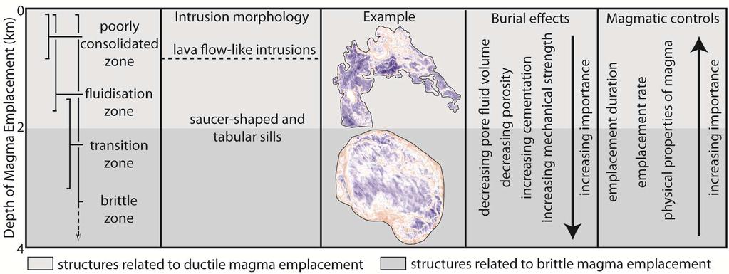
19 Lava-like intrusions: characteristic features of shallow depth magma emplacement? In our study, the hybrid intrusions with sinuous, lava flow-like shapes are restricted to shallow (<200 m) depths (e.g. intrusions 36, 37, 39). Other authors have similarly reported that intrusions emplaced in the shallowest hundreds of metres of sedimentary basins have lava flow-like morphologies (e.g. Fig. 13; Trude, 2004; Hansen and Cartwright, 2006; Miles and Cartwright, 2010). The lava flow-like shapes of the hybrid intrusions contrasts markedly with the saucer-shaped sills and laccoliths, which are typical morphologies for intrusions emplaced at depths of a few hundred metres or more (e.g. Planke et al., 2005; Polteau et al., 2008; Schofield et al., 2012b). These combined observations therefore suggest that lava flowlike sills represent a unique intrusion morphology that is characteristic of shallow depth magma intrusion (Fig. 14). We infer that the lava flow-like intrusions were dominantly emplaced by ductile mechanisms. This hypothesis is supported by data from the Gnarlyknots-1A well (see section 2) which indicates that the sediments within the Hammerhead Supersequence were watersaturated and had anomalously high porosity; conditions which favour ductile magma emplacement (Schofield et al., 2012b). Previous authors have focused on the importance of host rock rheology in controlling intrusion morphology (e.g. Schofield et al. 2010; Miles and Cartwright, 2010; Schofield et al. 2012b). In contrast, factors such as magma emplacement rate, emplacement duration and the physical properties of the magma have previously been neglected. However, these factors play an important role in governing the emplacement of lava flow fields (e.g. Hon et al., 1994; Soule et al., 2004). Although we cannot quantify these processes, we suggest that they are likely to play an increasingly dominant role in magma 446 emplacement at shallow depths (Fig. 14) Comparison with volcanic rifted margins 18
20 In our study, many of the intrusions are of small volume (<14 km 3 ), were emplaced at shallow depths (<1200 m) and are not laterally and vertically interconnected. This is in contrast to those found along volcanic rifted margins which are 10 s of km diameter and are found at depths ranging from <1 9 km (Planke et al., 2005; Schofield et al., 2015; Reynolds et al., 2017). These sills often form interconnected complexes (e.g. Planke et al., 2005; Schofield et al., 2015; Magee et al., 2016; Reynolds et al., 2017) and are capable of transporting magma vertically and laterally for 12 km and 4100 km respectively (Cartwright and Hansen, 2006; Magee et al., 2016). There are several factors which could account for the differing magma plumbing systems in the BBIC and those along volcanic rifted margins. As described in Section 6.1, we infer that the vertical distribution of the sills and laccoliths in this study partially results from dykes that ascended through the lithosphere at high rates. Magma ascent rate may therefore have also played a role in controlling the emplacement depth of sills along volcanic rifted margins. Although not well studied, magma ascent rate may have also influenced whether interlinked complexes of sills developed, as suggested by Magee et al., (2016) and references there-in. The volume of magma intruded may also partially influenced whether inter-linked sill complexes form; intrusions with as larger diameter are more likely to become interconnected than smaller diameter intrusions (see also Holt et al., 2013). In summary, whilst factors such as host rock lithology and elastic mismatch no doubt play an important role in governing the vertical distribution and interconnectedness of magmatic intrusions in sedimentary basins (see Magee et al., 2016 for a thorough review), our study highlights the potentially important role of magma ascent rate and magma volume 471 in influencing the architecture of magma plumbing systems in sedimentary basins Conclusions 19
21 We have shown that the Bight Basin Igneous Complex, offshore southern Australia, contains a variety of saucer-shaped, compound and hybrid sills, as well as laccoliths. Our 3D seismic data indicates that these intrusions were emplaced within 1200 m of the paleoseabed and are overlain by a series of forced folds, volcanogenic vents and lava flow fields. The spatial linkage between the lava flow fields and vent suggests that the intrusions played an important role in delivering magma to the paleoseabed. Many of the intrusions occur as isolated bodies, suggesting that they were fed by dykes. We infer that high magma ascent rates enabled magma propagating in dykes to bypass lithological interfaces, resulting in focusing of the intrusions in the shallow subsurface. Our study indicates that magma-poor rifted margins are characterised by a diversity of shallow-depth, dyke-fed intrusions, the manifestation of which is controlled intrinsic magma properties (e.g. ascent and emplacement rate, volume and physical properties) as well as host rock lithology. 8. References Autin, J., Leroy, S., Beslier, M. O., d'acremont, E., Razin, P., Ribodetti, A., & Al Toubi, K., 2010, Continental break-up history of a deep magma-poor margin based on seismic reflection data (northeastern Gulf of Aden margin, offshore Oman): Geophysical Journal International, v. 180, no. 2, p Brenna, M., Cronin, S. J., Németh, K., Smith, I. E. M., and Sohn, Y. K., 2011, The influence of magma plumbing complexity on monogenetic eruptions, Jeju Island, Korea: Terra Nova, v. 23, no. 2, p Cartwright, J., and Møller Hansen, D., 2006, Magma transport through the crust via interconnected sill complexes: Geology, v. 34, no. 11, p Cas, R., van Otterloo, J., Blaikie, T., and van den Hove, J., 2016, The dynamics of a very large intra-plate continental basaltic volcanic province, the Newer Volcanics 20
22 Province, SE Australia, and implications for other provinces: Geological Society, London, Special Publications, v. 446, p. SP Chanceaux, L., and Menand, T., 2014, Solidification effects on sill formation: An experimental approach: Earth and Planetary Science Letters, v. 403, p Chester, F. M., and Chester, J. S., 2000, Stress and deformation along wavy frictional faults: Journal of Geophysical Research: Solid Earth, v. 105, no. B10, p Clarke, J., and Alley, N., Petrologic data on the evolution of the Great Australian Bight, in Proceedings Proceedings of the Gondwana Eight Symposium: Rotterdam, AA Balkema1993, p Conrad, C. P., Bianco, T. A., Smith, E. I., and Wessel, P., 2011, Patterns of intraplate volcanism controlled by asthenospheric shear: Nature Geoscience, v. 4, no. 5, p Davies, D., Rawlinson, N., Iaffaldano, G., and Campbell, I., 2015, Lithospheric controls on magma composition along Earth/'s longest continental hotspot track: Nature, v. 525, no. 7570, p Demidjuk, Z., Turner, S., Sandiford, M., George, R., Foden, J., and Etheridge, M., 2007, U- series isotope and geodynamic constraints on mantle melting processes beneath the Newer Volcanic Province in South Australia: Earth and Planetary Science Letters, v. 261, no. 3, p Franke, D., Savva, D., Pubellier, M., Steuer, S., Mouly, B., Auxietre, J. L., & Chamot-Rooke, N., 2014, The final rifting evolution in the South China Sea: Marine and Petroleum Geology, v. 58, p Galland, O., Planke, S., Neumann, E.-R., and Malthe-Sørenssen, A., 2009, Experimental modelling of shallow magma emplacement: application to saucer-shaped intrusions: Earth and Planetary Science Letters, v. 277, no. 3, p
23 Gudmundsson, A., 2011, Deflection of dykes into sills at discontinuities and magma-chamber formation: Tectonophysics, v. 500, no. 1, p Hansen, D. M., and Cartwright, J., 2006, Saucer-shaped sill with lobate morphology revealed by 3D seismic data: implications for resolving a shallow-level sill emplacement mechanism: Journal of the Geological Society, v. 163, no. 3, p Holford, S., Schofield, N., MacDonald, J., Duddy, I., and Green, P., 2012, Seismic analysis of igneous systems in sedimentary basins and their impacts on hydrocarbon prospectivity: examples from the southern Australian margin, The APPEA Journal, v. 52, no. 1, p Holt, S., Holford, S., and Foden, J., 2013, New insights into the magmatic plumbing system of the South Australian Quaternary Basalt province from 3D seismic and geochemical data: Australian Journal of Earth Sciences, v. 60, no. 8, p Hon, K., Kauahikaua, J., Delinger, R., and Mackay, K., 1994, Emplacement and inflation of pahoehoe sheet flows: Observations and measurements of active lava flows on Kilauea Volcano, Hawaii: Geological Society of America Bulletin, v. 106, no. 3, p Jackson, M. D., and Pollard, D. D., 1990, Flexure and faulting of sedimentary host rocks during growth of igneous domes, Henry Mountains, Utah. Journal of Structural Geology 12.2: Jackson, C. A., 2012, Seismic reflection imaging and controls on the preservation of ancient sill-fed magmatic vents. Journal of the Geological Society v. 169, no. 5, p Jackson, C. A., Schofield, N., and Golenkov, B., 2013, Geometry and controls on the development of igneous sill related forced folds: A 2-D seismic reflection case study from offshore southern Australia: Geological Society of America Bulletin, v. 125, no , p
24 Jerram, D. A., 2002, Volcanology and facies architecture of flood basalts: Geological Society of America Special Papers, v. 362, p Kavanagh, J. L., Menand, T., and Sparks, R. S. J., 2006, An experimental investigation of sill formation and propagation in layered elastic media: Earth and Planetary Science Letters, v. 245, no. 3, p Keating, G., Valentine, G., Krier, D., and Perry, F., 2008, Shallow plumbing systems for small-volume basaltic volcanoes: Bulletin of Volcanology, v. 70, no. 5, p Langhi, L., Strand, J., and Ross, A. S., 2016, Fault-related biogenic mounds in the Ceduna Sub-basin, Australia. Implications for hydrocarbon migration: Marine and Petroleum Geology, v. 74, p Li, Q., James, N., and McGowran, B., 2003, Middle and Late Eocene Great Australian Bight lithobiostratigraphy and stepwise evolution of the southern Australian continental margin: Australian Journal of Earth Sciences, v. 50, no. 1, p Maccaferri, F., Bonafede, M., and Rivalta, E., 2011, A quantitative study of the mechanisms governing dike propagation, dike arrest and sill formation: Journal of Volcanology and Geothermal Research, v. 208, no. 1, p Macdonald, J., Backé, G., King, R., Holford, S., and Hillis, R., 2012, Geomechanical modelling of fault reactivation in the Ceduna Sub-basin, Bight Basin, Australia: Geological Society, London, Special Publications, v. 367, no. 1, p MacDonald, J., King, R., Hillis, R., and Backé, G., 2010, Structural style of the White Pointer and Hammerhead delta-deepwater fold-thrust belts, Bight Basin, Australia, The APPEA Journal, v. 50, no.1, p MacDonald, J. D., Holford, S. P., Green, P. F., Duddy, I. R., King, R. C., and Backé, G., 2013, Detrital zircon data reveal the origin of Australia s largest delta system: Journal of the Geological Society, v. 170, no. 1, p
25 Magee, C., Bastow, I. D., de Vries, B. v. W., Jackson, C. A.-L., Hetherington, R., Hagos, M., and Hoggett, M., 2017, Structure and dynamics of surface uplift induced by incremental sill emplacement: Geology, p. G Magee, C., Hunt-Stewart, E., and Jackson, C. A.-L., 2013, Volcano growth mechanisms and the role of sub-volcanic intrusions: insights from 2D seismic reflection data: Earth and Planetary Science Letters, v. 373, p Magee, C., Muirhead, J. D., Karvelas, A., Holford, S. P., Jackson, C. A., Bastow, I. D., Schofield, N., Stevenson, C. T., McLean, C., and McCarthy, W., 2016, Lateral magma flow in mafic sill complexes: Geosphere, v. 12, no. 3, p Malthe-Sørenssen, A., Planke, S., Svensen, H., and Jamtveit, B., 2004, Formation of saucershaped sills: Physical Geology of High-Level Magmatic Systems. Geological Society, London, Special Publications, v. 234, p McGee, L. E., Beier, C., Smith, I. E., and Turner, S. P., 2011, Dynamics of melting beneath a small-scale basaltic system: a U-Th Ra study from Rangitoto volcano, Auckland volcanic field, New Zealand: Contributions to Mineralogy and Petrology, v. 162, no. 3, p Meeuws, F., Holford, S., Foden, J., and Schofield, N., 2016, Distribution, chronology and causes of Cretaceous Cenozoic magmatism along the magma-poor rifted southern Australian margin: Links between mantle melting and basin formation: Marine and Petroleum Geology, v. 73, p Menand, T., 2011, Physical controls and depth of emplacement of igneous bodies: A review: Tectonophysics, v. 500, no. 1, p Miles, A., and Cartwright, J., 2010, Hybrid flow sills: a new mode of igneous sheet intrusion: Geology, v. 38, no. 4, p
26 Muirhead, J. D., Airoldi, G., White, J. D., and Rowland, J. V., 2014, Cracking the lid: Sill-fed dikes are the likely feeders of flood basalt eruptions: Earth and Planetary Science Letters, v. 406, p Muirhead, J. D., Eaton, A. R., Re, G., White, J. D. L., and Ort, M. H., 2016, Monogenetic volcanoes fed by interconnected dikes and sills in the Hopi Buttes volcanic field, Navajo Nation, USA: Bulletin of Volcanology, v. 78, no. 2, p Nelson, C. E., Jerram, D.A and Hobbs, R. W, 2009, Flood basalt facies from borehole data: implications for prospectivity and volcanology in volcanic rifted margins. Petroleum Geoscience v.15 no.4, p Peace, A., McCaffrey, K., Imber, J., Hobbs, R., van Hunen, J., and Gerdes, K., 2017, Quantifying the influence of sill intrusion on the thermal evolution of organic-rich sedimentary rocks in nonvolcanic passive margins: an example from ODP , offshore Newfoundland, Canada: Basin Research, v. 29, no. 3, p Planke, S., Rasmussen, T., Rey, S., and Myklebust, R., Seismic characteristics and distribution of volcanic intrusions and hydrothermal vent complexes in the Vøring and Møre basins, in Proceedings Geological Society, London, Petroleum Geology Conference series2005, v. 6, Geological Society of London, p Planke, S., Svensen, H., Myklebust, R., Bannister, S., Manton, B., and Lorenz, L., 2015, Geophysics and Remote Sensing, p.1-16, doi: /11157_2014_6 Planke, S., Symonds, P. A., Alvestad, E., and Skogseid, J., 2000, Seismic volcanostratigraphy of large-volume basaltic extrusive complexes on rifted margins: J. Geophys. Res., v. 105, no. B8, p Pollard, D D., and Johnson, A. M., 1973, Mechanics of growth of some laccolithic intrusions in the Henry Mountains, Utah, II: bending and failure of overburden layers and sill formation. Tectonophysics (1973):
27 Polteau, S., Mazzini, A., Galland, O., Planke, S., and Malthe-Sørenssen, A., 2008, Saucer- shaped intrusions: Occurrences, emplacement and implications: Earth and Planetary Science Letters, v. 266, no. 1 2, p Rateau, R., Schofield, N., and Smith, M., 2013, The potential role of igneous intrusions on hydrocarbon migration, West of Shetland: Petroleum Geoscience, v. 19, no. 3, p Reynolds, P., Planke, S., Millett, J., Jerram, D., Trulsvik, M., Schofield, N., and Myklebust, R., 2017, Hydrothermal vent complexes offshore Northeast Greenland: A potential role in driving the PETM: Earth and Planetary Science Letters, v. 467, p Reynolds, P., Schofield, N., Brown, R. J., and Holford, S., 2016, The architecture of submarine monogenetic volcanoes insights from 3D seismic data: Basin Research, doi: /bre Robson, A., King, R., and Holford, S., 2016, Structural evolution of a gravitationally detached normal fault array: analysis of 3D seismic data from the Ceduna Sub Basin, Great Australian Bight: Basin Research doi: /bre Rodriguez Monreal F., Villar H. J., Baudino R., Delpino D. and Zencich S., 2009, Modeling an atypical petroleum system: a case study of hydrocarbon generation, migration and accumulation related to igneous intrusions in the Neuqen Basin, Argentina: Marine and Petroleum Geology, v. 26, no. 4, p Schofield, A., and Totterdell, J., 2008, Distribution, timing and origin of magmatism in the Bight and Eucla Basins, Geoscience Australia. Schofield, N., Heaton, L., Holford, S. P., Archer, S. G., Jackson, C. A.-L., and Jolley, D. W., a, Seismic imaging of broken bridges : linking seismic to outcrop-scale investigations of intrusive magma lobes: Journal of the Geological Society, v. 169, no. 4, p
28 Schofield, N., Holford, S., Millett, J., Brown, D., Jolley, D., R. Passey, S., Muirhead, D., Grove, C., Magee, C., Murray, J., Hole, M., A.-L. Jackson, C., and Stevenson, C., 2015, Regional magma plumbing and emplacement mechanisms of the Faroe Shetland Sill Complex: implications for magma transport and petroleum systems within sedimentary basins: Basin Research, v. 29, p , doi: /bre Schofield, N., Stevenson, C., and Reston, T., 2010, Magma fingers and host rock fluidization in the emplacement of sills: Geology, v. 38, no. 1, p Schofield, N. J., Brown, D. J., Magee, C., and Stevenson, C. T., 2012b, Sill morphology and comparison of brittle and non-brittle emplacement mechanisms: Journal of the Geological Society, v. 169, no. 2, p Schutter, S R., 2003, Hydrocarbon occurrence and exploration in and around igneous rocks. Geological Society, London, Special Publications 214.1: Senger, K., Millett, J., Planke, S., Ogata, K., Eide, C., Festøy, M., Galland, O., and Jerram, D., 2017, Effects of igneous intrusions on the petroleum system: a review. First Break / Skogly, O.P., 1998, Seismic characterization and emplacement of intrusives in the Vøring Basin [Ph.D. thesis]: University of Oslo. Soule, S. A., Cashman, K. V., and Kauahikaua, J. P., 2004, Examining flow emplacement through the surface morphology of three rapidly emplaced, solidified lava flows, Kilauea Volcano, Hawai'i: Bulletin of Volcanology, v. 66, no. 1, p Suleiman, A., Magee, C., Jackson, C.-L., and Fraser, A., 2017, Igneous activity in the Bornu Basin, onshore NE Nigeria; implications for opening of the South Atlantic: Journal of the Geological Society, p. jgs
29 Svensen, H., Planke, S., Malthe-Sorenssen, A., Jamtveit, B., Myklebust, R., Rasmussen Eidem, T., and Rey, S. S., 2004, Release of methane from a volcanic basin as a mechanism for initial Eocene global warming: Nature, v. 429, no. 6991, p Symonds, P. A., PLanke, S., Frey, Ø and Skogside, J., 1998, Volcanic evolution of the Western Australian continental margin and its implications for basin development. In: Purcell, P.G and Purcell, R.R (eds) The Sedimentary Basins of Western Australia 2: Proceedings of Petroleum Exploration Society of Australia Symposium, Perth, Taisne, B., and Jaupart, C., 2011, Magma expansion and fragmentation in a propagating dyke: Earth and Planetary Science Letters, v. 301, no. 1, p Tapley, D., Mee, B., King, S., Davis, R., and Leischner, K., 2005, Petroleum potential of the Ceduna Sub-basin: impact of Gnarlyknots-1A: The APPEA Journal, v. 45, no. 1, p Thomson, K., 2007, Determining magma flow in sills, dykes and laccoliths and their implications for sill emplacement mechanisms: Bulletin of Volcanology, v. 70, no. 2, p Thomson, K., and Hutton, D., 2004, Geometry and growth of sill complexes: insights using 3D seismic from the North Rockall Trough: Bulletin of Volcanology, v. 66, no. 4, p Tikku, A. A., and Cande, S. C., 1999, The oldest magnetic anomalies in the Australian Antarctic Basin: Are they isochrons?: Journal of Geophysical Research: Solid Earth, v. 104, no. B1, p Tobias, S., Sigurd, K., Planke,. S., Magee, C., Galland, O., Schofield, N., Jackson, C., and Jerram, D., Mechanisms of overburden deformation associated with the emplacement of the Tulipan sill, mid-norwegian margin: Interpretation, v. 5, no. 3, SK23-SK38. doi.org/ /int
30 Totterdell, J., Blevin, J., Struckmeyer, H., Bradshaw, B., Colwell, J., and Kennard, J., 2000, Petroleum frontiers, systems and plays-a new sequence framework for the Great Australian Bight: Starting with a clean slate: APPEA Journal-Australian Petroleum Production and Exploration Association, v. 40, no. 1, p Totterdell, J., and Krassay, A., 2003, The role of shale deformation and growth faulting in the Late Cretaceous evolution of the Bight Basin, offshore southern Australia: Geological Society, London, Special Publications, v. 216, no. 1, p Trude, J., Cartwright, J., Davies, R. J., and Smallwood, J., 2003, New technique for dating igneous sills: Geology, v. 31, no. 9, p Trude, K., 2004, Kinematic Indicators for Shallow Level Igneous Intrusions from 3D Seismic Data: Evidence of Flow Firection and Feeder Location: Geological Society, London, Memoirs, v. 29, no. 1, p Valentine, G. A., and Krogh, K. E., 2006, Emplacement of shallow dikes and sills beneath a small basaltic volcanic center The role of pre-existing structure (Paiute Ridge, southern Nevada, USA): Earth and Planetary Science Letters, v. 246, no. 3, p van den Hove, J., Grose, L., Betts, P. G., Ailleres, L., Van Otterloo, J., and Cas, R. A. F., 2017, Spatial analysis of an intra-plate basaltic volcanic field in a compressional tectonic setting: South-eastern Australia: Journal of Volcanology and Geothermal Research, v. 335, p Van Otterloo, J., Raveggi, M., Cas, R., and Maas, R., 2014, Polymagmatic activity at the monogenetic Mt Gambier Volcanic Complex in the Newer Volcanics Province, SE Australia: new insights into the occurrence of intraplate volcanic activity in Australia: Journal of Petrology, v. 55, no. 7, p
31 Figure Captions Fig. 1. Map showing the location of the study area along the southern Australian margin and a stratigraphic column indicating that the intrusions are of Mid Eocene age Fig. 2. Composite seismic section using lines 43, 58, 85 and 92r from the Flinders 2D seismic survey. Uninterpreted version provided in Supplementary Data (Fig. S1). Fig. 3. Seismic cross sections through intrusion number S13, a saucer-shaped sill (A); intrusion number C27, a compound sill (B); intrusion number H36, hybrid sill (C) and intrusion number L4; a laccolith (D). Emplacement depth and amplitude maps are also shown. See Figure 4 for their locations. Fig. 4. Map showing the emplacement depth of the intrusions beneath the paleoseabed (the Base Dugong reflection). Fig. 5. Map showing the thickness variation within the intrusions. Fig. 6 Graphs showing the relationship between intrusion emplacement depth and distance towards break-up axis (A), diameter and emplacement depth (B) and volume and emplacement depth (C). Fig. 7. Seismic cross sections of sills 7 and 18 (A) and 12 and 24 (B). In A, the intrusions overlap but are not connected. These intrusions are typical of those within the Ceduna Subbasin. In the B the sills form a complex, perhaps allowing lateral and vertical transport of magma. Fig. 8. Map showing the direction of magma flow within the intrusions and their source regions. Fig. 9. 3D visualisation of a hybrid sill (number H20) showing time (A) and amplitude (B) maps and interpreted magma flow directions. The intrusion overlies a fault and is interpreted to have been fed by a dyke. See Fig. 8 for location. Fig. 10. Map showing the distribution of vents, lava flow fields and intrusions. 30
32 Fig. 11. Seismic cross section showing a vent onlapping onto forced folds above an intrusion, indicating that intrusive activity pre-dated eruption. See Fig. 10 for location. Fig. 12. Seismic section showing a saucer-shape sill and volcanogenic vents. The left-most vent is located above the shallowest termination of the sill ~200 m beneath the paleosurface. See Fig. 10 for location. Fig. 13. Outlines of the Krafla lava flow, Iceland (A), intrusion 36 from this study (B, emplacement depth ~100 m) and an intrusion offshore Norway emplaced at m depth (C; redrawn from Miles and Cartwright, 2010). The arrows indicate the direction of lava/magma flow. Note the similar sinuous morphologies and ragged terminations of each feature. Fig. 14. Schematic diagram illustrating the factors influencing intrusion morphology, and how emplacement processes vary with emplacement depth. Adapted from Schofield et al. (2012b). Acknowledgements This work comprises a part of the Great Australian Bight Deepwater Marine Program (GABDMP) for funding this project. The GABDMP is a CSIRO research program, sponsored by Chevron Australia the results of which will be made publically available. 3D seismic data was gratefully provided by TGS. Dougal Jerram and Craig Magee are thanked for constructive reviews; Adam Bumby is thanked for editorial handling. 31
33 Intrusion number Intrusion type Is the intrusion part of a complex? Length (km) Width (km) Aspect ratio Emplacement depth (m) Min volume* (km 3 ) Max volume (km 3 ) 1 Hybrid No Hybrid No Saucer Yes Laccolith No Saucer No Saucer No Hybrid No Saucer No Hybrid No Saucer No Laccolith No Saucer Yes Saucer Yes Hybrid No Hybrid No Compound No Hybrid Yes Hybrid No Hybrid No Hybrid No Hybrid No Saucer Yes Hybrid Yes Saucer Yes
34 25 Saucer Yes Saucer No Compound No Hybrid Yes Hybrid Yes Hybrid Yes Saucer Yes Hybrid Yes Saucer No Saucer No Hybrid Yes Hybrid Yes Hybrid No Hybrid No Saucer Yes Table 1. Measurements of intrusion dimensions. * assumes the intrusion is 5 m thick in areas where it is represented by a single troughpeak doublet. assumes the intrusion is 44 m thick in areas where it is represented by a single trough-peak doublet.

35

36

37
38
39
40

41

42

43
44
45

46

47


48
Interaction between Faults and Igneous Intrusions in Sedimentary Basins: Insights from 3D Seismic Reflection Data*
 Interaction between Faults and Igneous Intrusions in Sedimentary Basins: Insights from 3D Seismic Reflection Data* Craig Magee¹, Christopher A. Jackson¹, and Nick Schofield² Search and Discovery Article
Seismic stratigraphy, some examples from Indian Ocean, interpretation of reflection data in interactive mode
 Seismic stratigraphy, some examples from Indian Ocean, interpretation of reflection data in interactive mode K. S. Krishna National Institute of Oceanography, Dona Paula, Goa-403 004. krishna@nio.org Seismic
Earthquakes. Earthquakes are caused by a sudden release of energy
 Earthquakes Earthquakes are caused by a sudden release of energy The amount of energy released determines the magnitude of the earthquake Seismic waves carry the energy away from its origin Fig. 18.1 Origin
PUBLICATIONS. Geochemistry, Geophysics, Geosystems
 PUBLICATIONS RESEARCH ARTICLE Key Points: We 3-D seismic data from a buried Eocene-aged volcanic province to detail the morphology of submarine lava flows The lava flows contain complex distribution systems
Plate Tectonics. entirely rock both and rock
 Plate Tectonics I. Tectonics A. Tectonic Forces are forces generated from within Earth causing rock to become. B. 1. The study of the origin and arrangement of Earth surface including mountain belts, continents,
Global Tectonics. Kearey, Philip. Table of Contents ISBN-13: Historical perspective. 2. The interior of the Earth.
 Global Tectonics Kearey, Philip ISBN-13: 9781405107778 Table of Contents Preface. Acknowledgments. 1. Historical perspective. 1.1 Continental drift. 1.2 Sea floor spreading and the birth of plate tectonics.
Controls on clastic systems in the Angoche basin, Mozambique: tectonics, contourites and petroleum systems
 P2-2-13 Controls on clastic systems in the Angoche basin, Mozambique: tectonics, contourites and petroleum systems Eva Hollebeek, Olivia Osicki, Duplo Kornpihl Schlumberger, London, UK Introduction Offshore
A) B) C) D) 4. Which diagram below best represents the pattern of magnetic orientation in the seafloor on the west (left) side of the ocean ridge?
 B) C) D) 4. Which diagram below best represents the pattern of magnetic orientation in the seafloor on the west (left) side of the ocean ridge?") 1. Crustal formation, which may cause the widening of an ocean, is most likely occurring at the boundary between the A) African Plate and the Eurasian Plate B) Pacific Plate and the Philippine Plate C)
1. Crustal formation, which may cause the widening of an ocean, is most likely occurring at the boundary between the A) African Plate and the Eurasian Plate B) Pacific Plate and the Philippine Plate C)
Answers: Internal Processes and Structures (Isostasy)
") Answers: Internal Processes and Structures (Isostasy) 1. Analyse the adjustment of the crust to changes in loads associated with volcanism, mountain building, erosion, and glaciation by using the concept
Answers: Internal Processes and Structures (Isostasy) 1. Analyse the adjustment of the crust to changes in loads associated with volcanism, mountain building, erosion, and glaciation by using the concept
Section 10.1 The Nature of Volcanic Eruptions This section discusses volcanic eruptions, types of volcanoes, and other volcanic landforms.
 Chapter 10 Section 10.1 The Nature of Volcanic Eruptions This section discusses volcanic eruptions, types of volcanoes, and other volcanic landforms. Reading Strategy Previewing Before you read the section,
A Revised Interpretation of 3D Seismic Data, Hawthorne Army Depot, Nevada: Faulted Basin Reflections or Sill Intrusions?
 A Revised Interpretation of 3D Seismic Data, Hawthorne Army Depot, Nevada: Faulted Basin Reflections or Sill Intrusions? Annie Kell Hills 1, Louie, J. 1, Kent, G. 1, Pullammanappallil, S. 2, Sabin, A.
24. Ocean Basins p
 24. Ocean Basins p. 350-372 Background The majority of the planet is covered by ocean- about %. So the majority of the Earth s crust is. This crust is hidden from view beneath the water so it is not as
Chapter 10: Volcanoes and Other Igneous Activity Section 1: The Nature of Volcanic Eruptions I. Factors Affecting Eruptions Group # Main Idea:
 Chapter 10: Volcanoes and Other Igneous Activity Section 1: The Nature of Volcanic Eruptions I. Factors Affecting Eruptions Group # A. Viscosity Group # B. Dissolved Gases Group # II. Volcanic Material
MUHAMMAD S TAMANNAI, DOUGLAS WINSTONE, IAN DEIGHTON & PETER CONN, TGS Nopec Geological Products and Services, London, United Kingdom
 Geological and Geophysical Evaluation of Offshore Morondava Frontier Basin based on Satellite Gravity, Well and regional 2D Seismic Data Interpretation MUHAMMAD S TAMANNAI, DOUGLAS WINSTONE, IAN DEIGHTON
PHYSICAL GEOLOGY AND THE ENVIRONMENT (2 ND CANADIAN EDITION)
") Chapter 2: Plate Tectonics Chapter Summary: Plate tectonics is a theory that suggests Earth's surface is divided into several large plates that change position and size. Intense geologic activity occurs
Chapter 2: Plate Tectonics Chapter Summary: Plate tectonics is a theory that suggests Earth's surface is divided into several large plates that change position and size. Intense geologic activity occurs
Topics. Magma Ascent and Emplacement. Magma Generation. Magma Rise. Energy Sources. Instabilities. How does magma ascend? How do dikes form?
 Magma Ascent and Emplacement Reading: Encyclopedia of Volcanoes: Physical Properties of Magmas (pp. 171-190) Magma Chambers (pp. 191-206) Plumbing Systems (pp. 219-236) Magma ascent at shallow levels (pp.237-249)
Strike-Slip Faults. ! Fault motion is parallel to the strike of the fault.
 Strike-Slip Faults! Fault motion is parallel to the strike of the fault.! Usually vertical, no hanging-wall/footwall blocks.! Classified by the relative sense of motion. " Right lateral opposite block
EDIMENTARY BASINS. What is a Sedimentary Basin? by Prof. Dr. Abbas Mansour
 EDIMENTARY BASINS What is a Sedimentary Basin? by Prof. Dr. Abbas Mansour WHAT IS A SEDIMENTARY BASIN? A low area on the Earth s surface relative to surroundings e.g. deep ocean basin (5-10 km deep) e.g.
COMPOSITION and PHYSICAL PROPERTIES GENERAL SUBJECTS. GEODESY and GRAVITY
 COMPOSITION and PHYSICAL PROPERTIES Composition and structure of the continental crust Composition and structure of the core Composition and structure of the mantle Composition and structure of the oceanic
10. Paleomagnetism and Polar Wandering Curves.
 Map of ocean floor Evidence in Support of the Theory of Plate Tectonics 10. Paleomagnetism and Polar Wandering Curves. The Earth's magnetic field behaves as if there were a bar magnet in the center of
GEOLOGY MEDIA SUITE Chapter 12
 UNDERSTANDING EARTH, SIXTH EDITION GROTZINGER JORDAN GEOLOGY MEDIA SUITE Chapter 12 Volcanoes 2010 W.H. Freeman and Company Plate tectonics explains the global pattern of volcanism. Key Figure 12.20 (page
Northern Houtman Sub-basin prospectivity preliminary results
 Northern Houtman Sub-basin prospectivity preliminary results Irina Borissova, Chris Southby, George Bernardel, Jennifer Totterdell, Robbie Morris & Ryan Owens Geoscience Australia, GPO Box 378, Canberra
Meandering Miocene Deep Sea Channel Systems Offshore Congo, West Africa
 Meandering Miocene Deep Sea Channel Systems Offshore Congo, West Africa S. Baer* (PGS), J. E. Comstock (PGS), K. Vrålstad (PGS), R. Borsato (PGS), M. Martin (PGS), J.P. Saba (SNPC), B. Débi-Obambé (SNPC)
Chapter 2: Plate Tectonics: A Unifying Theory
 Chapter 2: Plate Tectonics: A Unifying Theory Chapter Outline 2.1 Introduction 2.2 Early Ideas About Continental Drift 2.3 What Is the Evidence for Continental Drift? 2.4 Features of the Seafloor 2.5 Earth
USU 1360 TECTONICS / PROCESSES
 USU 1360 TECTONICS / PROCESSES Observe the world map and each enlargement Pacific Northwest Tibet South America Japan 03.00.a1 South Atlantic Arabian Peninsula Observe features near the Pacific Northwest
Questions and Topics
 Plate Tectonics and Continental Drift Questions and Topics 1. What are the theories of Plate Tectonics and Continental Drift? 2. What is the evidence that Continents move? 3. What are the forces that
UGRC 144 Science and Technology in Our Lives/Geohazards
 UGRC 144 Science and Technology in Our Lives/Geohazards Session 5 Magma and Volcanism Lecturer: Dr. Patrick Asamoah Sakyi Department of Earth Science, UG Contact Information: pasakyi@ug.edu.gh College
Orphan Basin, Offshore Newfoundland: New seismic data and hydrocarbon plays for a dormant Frontier Basin
 Orphan Basin, Offshore Newfoundland: New seismic data and hydrocarbon plays for a dormant Frontier Basin Jerry Smee* G&G Exploration Consulting, 301 400-3rd Avenue SW, Calgary, AB, T2P 4H2 Sam Nader, Paul
Topic 12: Dynamic Earth Pracatice
 Name: Topic 12: Dynamic Earth Pracatice 1. Earth s outer core is best inferred to be A) liquid, with an average density of approximately 4 g/cm 3 B) liquid, with an average density of approximately 11
ANOTHER MEXICAN EARTHQUAKE! Magnitude 7.1, Tuesday Sept. 19, 2017
 ANOTHER MEXICAN EARTHQUAKE! Magnitude 7.1, Tuesday Sept. 19, 2017 Why is there no oceanic crust older than 200 million years? SUBDUCTION If new oceanic crust is being continuously created along the earth
BALOCHISTAN FOLDBELT BASIN
 INTRODUCTION BALOCHISTAN FOLDBELT BASIN The Kharan-3 block is located in the Kharan Trough of Balochistan Basin. GEOLOGICAL SETTING The Balochistan Province is an Upper Cretaceous to Recent structurally
Geologic Evolution of Latin America. Plate Tectonics: General Concepts & Applications to Latin America
 Geologic Evolution of Latin America Plate Tectonics: General Concepts & Applications to Latin America Structure of Earth: 3 major divisions of Core, Mantle, and Crust Upper mantle differs in the way that
The influence of short wavelength variations in viscosity on subduction dynamics
 1 Introduction Deformation within the earth, driven by mantle convection due primarily to cooling and subduction of oceanic lithosphere, is expressed at every length scale in various geophysical observations.
The Lithosphere and the Tectonic System. The Structure of the Earth. Temperature 3000º ºC. Mantle
 The Lithosphere and the Tectonic System Objectives: Understand the structure of the planet Earth Review the geologic timescale as a point of reference for the history of the Earth Examine the major relief
Continental Margin Geology of Korea : Review and constraints on the opening of the East Sea (Japan Sea)
") Continental Margin Geology of Korea : Review and constraints on the opening of the East Sea (Japan Sea) Han-Joon Kim Marine Satellite & Observation Tech. Korea Ocean Research and Development Institute
Continental Margin Geology of Korea : Review and constraints on the opening of the East Sea (Japan Sea) Han-Joon Kim Marine Satellite & Observation Tech. Korea Ocean Research and Development Institute
Geosphere Lateral magma flow in mafic sill-complexes
 Geosphere Lateral magma flow in mafic sill-complexes --Manuscript Draft-- Manuscript Number: Full Title: Short Title: Article Type: Keywords: Corresponding Author: GS1256R1 Lateral magma flow in mafic
Do deep mantle plumes explain the Mesozoic igneous features of New England?
 Do deep mantle plumes explain the Mesozoic igneous features of New England? J. Gregory McHone 9 Dexters Lane, Grand Manan, New Brunswick, Canada E5G3A6 greg@earth2geologists.net Hotspots are regions of
Marine Science and Oceanography
 Marine Science and Oceanography Marine geology- study of the ocean floor Physical oceanography- study of waves, currents, and tides Marine biology study of nature and distribution of marine organisms Chemical
Directed Reading. Section: Volcanoes and Plate Tectonics
 Skills Worksheet Directed Reading Section: Volcanoes and Plate Tectonics 1. What can cause some of the most dramatic changes to Earth s surface? a. solar activity b. tides c. geysers d. volcanic eruptions
Prentice Hall EARTH SCIENCE
 Prentice Hall EARTH SCIENCE Tarbuck Lutgens Chapter 10 Volcanoes and Other Igneous Activity 10.1 The Nature of Volcanic Eruptions Factors Affecting Eruptions Factors that determine the violence of an eruption
Copyright McGraw-Hill Education. All rights reserved. No reproduction or distribution without the prior written consent of McGraw-Hill Education
 Copyright McGraw-Hill Education. All rights reserved. No reproduction or distribution without the prior written consent of McGraw-Hill Education Tibetan Plateau and Himalaya -southern Asia 11.00.a VE 10X
Plate Tectonics: A Scientific Revolution Unfolds
 Chapter 2 Lecture Earth: An Introduction to Physical Geology Eleventh Edition Plate Tectonics: A Scientific Revolution Unfolds Tarbuck and Lutgens From Continental Drift to Plate Tectonics Prior to the
Petroleum geology framework, West Coast offshore region
 Petroleum geology framework, West Coast offshore region James W. Haggart* Geological Survey of Canada, Vancouver, BC jhaggart@nrcan.gc.ca James R. Dietrich Geological Survey of Canada, Calgary, AB and
Lecture Marine Provinces
 Lecture Marine Provinces Measuring bathymetry Ocean depths and topography of ocean floor Sounding Rope/wire with heavy weight Known as lead lining Echo sounding Reflection of sound signals 1925 German
Sequence Stratigraphy. Historical Perspective
 Sequence Stratigraphy Historical Perspective Sequence Stratigraphy Sequence Stratigraphy is the subdivision of sedimentary basin fills into genetic packages bounded by unconformities and their correlative
Imagine the first rock and the cycles that it has been through.
 A rock is a naturally formed, consolidated material usually composed of grains of one or more minerals The rock cycle shows how one type of rocky material gets transformed into another The Rock Cycle Representation
Introduction to Prospecting. Session Two Geology
 Introduction to Prospecting Session Two Geology The Earth Earth is 4.6 billion years old (Ba). Bacteria & algae +3.5 Ba. Microscopic animals ~2 Ba. Animals ~600 million years (Ma) old. Mankind about 100,000
Late 20 th Century Tests of the Continental Drift Hypothesis
 Late 20 th Century Tests of the Continental Drift Hypothesis 5 Characteristics of the Ocean Trenches Unless otherwise noted the artwork and photographs in this slide show are original and by Burt Carter.
Igneous Rocks. Igneous Rocks. Genetic Classification of
 Igneous Rocks Fig. 5.1 Genetic Classification of Igneous Rocks Intrusive: crystallized from slowly cooling magma intruded within the Earth s crust; e.g. granite, gabbro 1 Fig. 5.2 Genetic Classification
YORK CASTLE HIGH SCHOOL CHRISTMAS TERM EXAMINATIONS GEOGRAPHY Duration 1 1 /2 HRS.
 GRADE 9 YORK CASTLE HIGH SCHOOL CHRISTMAS TERM EXAMINATIONS GEOGRAPHY Duration 1 1 /2 HRS. Name: 1. Label the internal structure of the earth provided below. WRITE on the space provide. Oceanic Crust/Upper
Continental Landscapes
 Continental Landscapes Landscape influenced by tectonics, climate & differential weathering Most landforms developed within the last 2 million years System moves toward an equilibrium Continental Landscapes
GEOLOGY CURRICULUM. Unit 1: Introduction to Geology
 Chariho Regional School District - Science Curriculum September, 2016 GEOLOGY CURRICULUM Unit 1: Introduction to Geology OVERVIEW Summary In this unit students will be introduced to the field of geology.
What Forces Drive Plate Tectonics?
 What Forces Drive Plate Tectonics? The tectonic plates are moving, but with varying rates and directions. What hypotheses have been proposed to explain the plate motion? Convection Cells in the Mantle
The Sea Floor. Chapter 2
 The Sea Floor Chapter 2 Geography of the Ocean Basins World ocean is the predominant feature on the Earth in total area Northern Hemisphere = 61% of the total area is ocean. Southern Hemisphere = about
Crustal Activity. Plate Tectonics - Plates - Lithosphere - Asthenosphere - Earth s surface consists of a major plates and some minor ones
 Name: Date: Period: Tectonics The Physical Setting: Earth Science CLASS NOTES Tectonics - s - Lithosphere - Asthenosphere - Earth s surface consists of a major plates and some minor ones The plates are
UNIT 3 GEOLOGY VOCABULARY FLASHCARDS THESE KEY VOCABULARY WORDS AND PHRASES APPEAR ON THE UNIT 3 CBA
 UNIT 3 GEOLOGY VOCABULARY FLASHCARDS THESE KEY VOCABULARY WORDS AND PHRASES APPEAR ON THE UNIT 3 CBA A map that shows Earth s Topographic Map surface topography, which is Earth s shape and features Contour
Plate Tectonics Lab II: Background Information
 Plate Tectonics Lab II: Background Information This lab is based on a UW ESS101 Lab. Note: Hand in only the Answer Sheet at the back of this guide to your Instructor Introduction One of the more fundamental
Lab 1: Plate Tectonics April 2, 2009
 Name: Lab 1: Plate Tectonics April 2, 2009 Objective: Students will be introduced to the theory of plate tectonics and different styles of plate margins and interactions. Introduction The planet can be
Chapter 16. Mountain Building. Mountain Building. Mountains and Plate Tectonics. what s the connection?
 Chapter 16 Mountains and Plate Tectonics what s the connection? Mountain Building Most crustal deformation occurs along plate margins. S.2 Active Margin Passive Margin Mountain Building Factors Affecting
Full file at
 Chapter 2 PLATE TECTONICS AND PHYSICAL HAZARDS MULTIPLE-CHOICE QUESTIONS 1. What direction is the Pacific Plate currently moving, based on the chain of Hawaiian Islands with only the easternmost island
6. In the diagram below, letters A and B represent locations near the edge of a continent.
 1. Base your answer to the following question on the cross section below and on your knowledge of Earth science. The cross section represents the distance and age of ocean-floor bedrock found on both sides
Chapter 02 The Sea Floor
 Chapter 02 The Sea Floor Multiple Choice Questions 1. One of the following is not one of the world's major ocean basins: A. Atlantic Ocean B. Arctic Ocean C. Indian Ocean D. Antarctic Ocean E. Pacific
Divergent Boundaries: Origin and Evolution of the Ocean Floor Earth - Chapter 13 Stan Hatfield Southwestern Illinois College
 Divergent Boundaries: Origin and Evolution of the Ocean Floor Earth - Chapter 13 Stan Hatfield Southwestern Illinois College Mapping the Ocean Floor Depth was originally measured by lowering weighted lines
Topic 5: The Dynamic Crust (workbook p ) Evidence that Earth s crust has shifted and changed in both the past and the present is shown by:
 Evidence that Earth s crust has shifted and changed in both the past and the present is shown by:") Topic 5: The Dynamic Crust (workbook p. 65-85) Evidence that Earth s crust has shifted and changed in both the past and the present is shown by: --sedimentary horizontal rock layers (strata) are found
Topic 5: The Dynamic Crust (workbook p. 65-85) Evidence that Earth s crust has shifted and changed in both the past and the present is shown by: --sedimentary horizontal rock layers (strata) are found
Plate Tectonics. Structure of the Earth
 Plate Tectonics Structure of the Earth The Earth can be considered as being made up of a series of concentric spheres, each made up of materials that differ in terms of composition and mechanical properties.
Origin and Evolution of the Ocean Floor
 Origin and Evolution of the Ocean Floor Outline Mapping the Ocean Floor Continental Margins Origin of Oceanic Lithosphere Structure of Ocean Crust Mapping the ocean floor Depth originally measured by lowering
Directed Reading. Section: Volcanoes and Plate Tectonics
 Skills Worksheet Directed Reading Section: Volcanoes and Plate Tectonics 1. Some volcanic eruptions can be more powerful than a(n) a. hand grenade. b. earthquake. c. geyser. d. atomic bomb. 2. The cause
Physical Geology, 15/e
 Lecture Outlines Physical Geology, 15/e Plummer, Carlson & Hammersley Plate Tectonics: The Unifying Theory Physical Geology 15/e, Chapter 19 Plate Tectonics Plate Tectonics Earth s surface is composed
SEDIMENTARY BASINS Red Sea Coast of Egypt. by Prof. Dr. Abbas Mansour
 SEDIMENTARY BASINS Red Sea Coast of Egypt by Prof. Dr. Abbas Mansour Sedimentary basins Sedimentary basins are, in a very broad sense, all those areas in which sediments can accumulate to considerable
Depositional Sequences Sequences
 Depositional Sequences Transgressive and Regressive packages can be bound by unconformities Because sediment can only be preserved during net aggradation and progradation All other times there is either
Magma. Objectives. Describe factors that affect the formation of magma. Compare and contrast the different types of magma. Vocabulary.
 Magma Objectives Describe factors that affect the formation of magma. Compare and contrast the different types of magma. Vocabulary viscosity Magma Magma The ash that spews from some volcanoes can form
Before Plate Tectonics: Theory of Continental Drift
 Before Plate Tectonics: Theory of Continental Drift Predecessor to modern plate tectonics Shape and fit of the continents was the initial evidence Snider-Pelligrini (1858) Taylor (1908) Wegner (1915) Fig.
Chapter 7 Plate Tectonics
 Chapter 7 Plate Tectonics Earthquakes Earthquake = vibration of the Earth produced by the rapid release of energy. Seismic Waves Focus = the place within the Earth where the rock breaks, producing an earthquake.
Evolution of Continents Chapter 20
 Evolution of Continents Chapter 20 Does not contain complete lecture notes. Mountain belts Orogenesis the processes that collectively produce a mountain belt Includes folding, thrust faulting, metamorphism,
Name Class Date. Study Guide for 7 th Grade Final Exam (Semester One)
") Name Class Date Study Guide for 7 th Grade Final Exam (Semester One) 1. What are the steps of the scientific method? Define the problem or question Form a hypothesis (MUST BE TESTABLE) o (identify variables)
Name Class Date Study Guide for 7 th Grade Final Exam (Semester One) 1. What are the steps of the scientific method? Define the problem or question Form a hypothesis (MUST BE TESTABLE) o (identify variables)
A comparison of structural styles and prospectivity along the Atlantic margin from Senegal to Benin. Peter Conn*, Ian Deighton* & Dario Chisari*
 A comparison of structural styles and prospectivity along the Atlantic margin from Senegal to Benin Overview Peter Conn*, Ian Deighton* & Dario Chisari* * TGS, Millbank House, Surbiton, UK, KT6 6AP The
INTRODUCTION AND OCCURRENCE
 5. Volcanics 2 Pyroclastic Rocks ED HT 3. Igneous Textures & Classification IG PY R CO 4. Volcanics 1 Lava Flows 1. Introduction and Occurrence AL RI TE MA 2. Field Skills & Outcrop Structures Early map
Geology 1 st Semester Exam YSBAT
 1. What is the role of a geologist? Geology 1 st Semester Exam YSBAT 2016-2017 2. Earth is subdivided into three main layers based on what? 3. What features do you find at divergent boundaries? 4. Rock
NC Earth Science Essential Standards
 NC Earth Science Essential Standards EEn. 2.1 Explain how processes and forces affect the Lithosphere. EEn. 2.1.1 Explain how the rock cycle, plate tectonics, volcanoes, and earthquakes impact the Lithosphere.
12. The diagram below shows the collision of an oceanic plate and a continental plate.
 Review 1. Base your answer to the following question on the cross section below, which shows the boundary between two lithospheric plates. Point X is a location in the continental lithosphere. The depth
Dynamic Crust Practice
 1. Base your answer to the following question on the cross section below and on your knowledge of Earth science. The cross section represents the distance and age of ocean-floor bedrock found on both sides
4D stress sensitivity of dry rock frame moduli: constraints from geomechanical integration
 Title 4D stress sensitivity of dry rock frame moduli: constraints from geomechanical integration Authors Bloomer, D., Ikon Science Asia Pacific Reynolds, S., Ikon Science Asia Pacific Pavlova, M., Origin
Section 7. Reading the Geologic History of Your Community. What Do You See? Think About It. Investigate. Learning Outcomes
 Chapter 3 Minerals, Rocks, and Structures Section 7 Reading the Geologic History of Your Community What Do You See? Learning Outcomes In this section, you will Goals Text Learning Outcomes In this section,
Foundations of Earth Science Seventh Edition
 Chapter 5 Lecture Outline Foundations of Earth Science Seventh Edition Plate Tectonics: A Scientific Revolution Unfolds Natalie Bursztyn Utah State University From Continental Drift to Plate Tectonics
Earth / Environmental Science. Ch. 14 THE OCEAN FLOOR
 Earth / Environmental Science Ch. 14 THE OCEAN FLOOR The Blue Planet Nearly 70% of the Earth s surface is covered by the global ocean It was not until the 1800s that the ocean became an important focus
Practice Questions: Plate Tectonics
 Practice Questions: Plate Tectonics 1. Base your answer to the following question on The block diagram below shows the boundary between two tectonic plates. Which type of plate boundary is shown? A) divergent
Geomorphology Final Exam Study Guide
 Geomorphology Final Exam Study Guide Geologic Structures STRUCTURAL GEOLOGY concerned with shapes, arrangement, interrelationships of bedrock units & endogenic (within) forces that cause them. Tectonic
Full file at
 Essentials of Oceanography, 10e (Trujillo/Keller) Chapter 2 Plate Tectonics and the Ocean Floor Match the term with the appropriate phrase. You may use each answer once, more than once or not at all. A)
Captain s Tryouts 2017
 Captain s Tryouts 2017 Dynamic Planet Test Written by: Araneesh Pratap (Chattahoochee High School) Name: Date: Answer all questions on the answer sheet. Point values are given next to each question or
Petroleum Potential of the Application Area L12-4
 Petroleum Potential of the Application Area L12-4 The Application Area (L12-4) is underlain by the western Officer Basin, beneath the Gunbarrel Basin. The general basin architecture is outlined in Figure
The Four Layers The Earth is composed of four different layers. The crust is the layer that you live on, and it is the most widely studied and
 Earth s Structure The Four Layers The Earth is composed of four different layers. The crust is the layer that you live on, and it is the most widely studied and understood. The mantle is much hotter and
Constitution of Magmas. Magmas. Gas Law. Composition. Atomic Structure of Magma. Structural Model. PV = nrt H 2 O + O -2 = 2(OH) -
 -") Constitution of Magmas Magmas Best, Ch. 8 Hot molten rock T = 700-1200 degrees C Composed of ions or complexes Phase Homogeneous Separable part of the system With an interface Composition Most components
Constitution of Magmas Magmas Best, Ch. 8 Hot molten rock T = 700-1200 degrees C Composed of ions or complexes Phase Homogeneous Separable part of the system With an interface Composition Most components
Forces That Shape Earth. How do continents move? What forces can change rocks? How does plate motion affect the rock cycle?
 Forces That Shape Earth How do continents move? What forces can change rocks? How does plate motion affect the rock cycle? Plate Motion Mountain ranges are produced by plate tectonics. The theory of plate
EARTH S ENERGY SOURCES
 EARTH S ENERGY SOURCES The geological processes that shape the Earth s surface are powered by two major sources of energy; geothermal heat from the Earth s interior and external energy from the sun. The
GLY 155 Introduction to Physical Geology, W. Altermann. Press & Siever, compressive forces. Compressive forces cause folding and faulting.
 Press & Siever, 1995 compressive forces Compressive forces cause folding and faulting. faults 1 Uplift is followed by erosion, which creates new horizontal surface. lava flows Volcanic eruptions cover
Crustal Boundaries. As they move across the asthenosphere and form plate boundaries they interact in various ways. Convergent Transform Divergent
 Name: Date: Period: Plate Tectonics The Physical Setting: Earth Science CLASS NOTES Tectonic plates are constantly moving and interacting As they move across the asthenosphere and form plate boundaries
Name Class Date. 1. What is the outermost layer of the Earth called?. a. core b. lithosphere c. asthenosphere d. mesosphere
 Name Class Date Assessment Geology Plate Tectonics MULTIPLE CHOICE Write the letter of the correct answer in the space provided. 1. What is the outermost layer of the Earth called?. a. core b. lithosphere
Theory of Plate Tectonics
 Plate Tectonics Theory of Plate Tectonics Lithosphere is made of sections called plates that move around called continental drift Plates move because they float on the asthenosphere Most plates consist
Prentice Hall EARTH SCIENCE
 Prentice Hall EARTH SCIENCE Tarbuck Lutgens Chapter 9 Plate Tectonics 9.1 Continental Drift An Idea Before Its Time Wegener s continental drift hypothesis stated that the continents had once been joined
Prentice Hall EARTH SCIENCE
 Prentice Hall EARTH SCIENCE Tarbuck Lutgens Chapter 9 Plate Tectonics 9.1 Continental Drift An Idea Before Its Time Wegener s continental drift hypothesis stated that the continents had once been joined