Retaggio culturale, gessi messiniani e Geoparco del Monticino
|
|
|
- Rolf Burns
- 5 years ago
- Views:
Transcription

1 Retaggio culturale, gessi messiniani e Geoparco del Monticino Gian Battista Vai Dipartimento di Scienze Biologiche, Geologiche e Ambientali Museo Geologico Giovanni Capellini SMA Alma Mater Studiorum - Università di Bologna RER-AIGT Convegno Il Patrimonio Geologico Bologna, 7-8 Giugno, 2018


2 WHAT IS THE MESSINIAN SALINITY CRISIS IN THE MEDITERRANEAN?
3 WHO HAS INTRODUCED THE CONCEPT AND TERMS OF SALINITY CRISIS? This is a Bolognese idea, as Bolognese was Marsili who discovered the line of gypsum along the whole Apennine Chain Pioniers Ulisse Aldrovandi about 1580 Luigi Ferdinando Marsili 1717 Player Raimondo Selli 1954, 1960, 1964 Seconds Leo Ogniben 1957 Giuliano Ruggieri 1967
 Durante il Miocene superiore si è")

4 Selli (1954) Durante il Miocene superiore tutto il Mediterraneo occidentale era un enorme lago-mare sovrasalato, isolato dall Atlantico Selli (1960) Durante il Miocene superiore si è avuta in tutto il Mediterraneo una crisi di salinità per cui nei bacini orientali della Paratetide regnava un ambiente sottosalato, invece nel Mediterraneo occidentale un mare iperalino (selli 1954)

5 Actually, pioneering hints to the MSC have been suspected in Leonardo da Vinci s Leicester Codex. However, cross-checking in Leonardo s geological description of the Lamone Valley, where he introduced concept and name of the Blue Clay Fm, fails to find reference to gypsum fm Leonardo da Vinci ( )
 where Leonardo discusses the desiccation of the Mediterranean Sea, except for the bottom in front of the Nile the largest river")
6 Detail from Leicester Codex (f. 10 r) where Leonardo discusses the desiccation of the Mediterranean Sea, except for the bottom in front of the Nile the largest river flowing in it The lower drawing shows a method of measuring the water evaporation, as explained in the text


7 Thus, earliest studies of Messinian evaporites in the Apennines occur in Aldrovandi s and Marsili s printed works and manuscripts

8 For Bologna people to be familiar with the special Apennine gypsum was common place given the wide use of this stone since Roman time and especially in the first Millenium city wall called selenite circle Fig Del Monte

9 Selenite, the most characteristic Bologna building ( actually waterrepellent and ornamental) stone, was well known to Pliny the Elder who, once he found clear and pure specimen, called it lapis specularis or mirror stone
 was Aldrovandi s ex libris or motto, in the sense that this book was used for team work as")
10 Aldrovandi carefully read and annotated Pliny s Naturalis Historia in 1563 Ulissis Aldrovandi, et amicorum (or Ulisse Aldrovandi s and friends ) was Aldrovandi s ex libris or motto, in the sense that this book was used for team work as introduced by A.
 Along the Apennines of Italy many Gypsum ridges are observed Plinius Specularem lapidem, et Selenitem indigitat, quia perspicuus sit, instar speculi (p.")
11 In Apennino Italiae monte passim multae Gypsi venae observantur (p. 674) Along the Apennines of Italy many Gypsum ridges are observed Plinius Specularem lapidem, et Selenitem indigitat, quia perspicuus sit, instar speculi (p. 678) Pliny defines also Selenite as Mirror stone because it is transparent like a glass


12 1648 about 1580

 Goethe s")
13 However, an additional Bologna stone became renown in Europe after a publication by L.F. Marsili in It was barite (barium sulphate) called the Bolognese Phosphoric Stone for being luminescent (1602) Goethe s Reise in Italien in 1786

14 Marsili s work on the Bologna Stone (1698) contains a chapter devoted to gypsum quarries of the Bologna area also close to Mount Paderno Different kinds of gypsum in a Bologna San Ruffillo quarry are labelled by small numbers in Fig. L and described in the text I found in the BUL the original early Marsili s drawing 25 sketching quarry workers and prepared for the engraver of Fig L

15 Our secondary, sericolite gypsum filling fractures and faults

16 World s earliest geological sketch map, Romagna Apennines, sulphur mine area < 1717


17 G. Scarabelli s geological map of the same sulphur mine area 1869
18 Marsili 1717 la Mappa da Ancona a Parma mostrerà la Linea del Gesso e Solfi longo l Apenino

19 Eccola la Linea o Vena del Gesso di L.F. Marsili

20
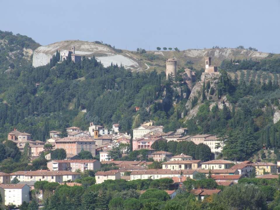
21 Il Geoparco di Brisighella Parco Museo Geologico Cava Monticino

22 Discordanza intra-messiniana Gessi/Colombacci e Argille Azzurre

23 Pliocene Inf. in facies Trubi in Nord Italia al Monticino

24 Pliocene Inf. in facies Trubi in Sicilia alla Scala dei Turchi
25

26 Stratigrafia della Vena del Gesso Romagnola

27 Il Geoparco del Monticino di Brisighella

28 Dalla Cava al Geoparco ( )

29

30

31

32

33 1 cm

34

35 Giugno 2006

36

37

38
39

40 Sic transit gloria mundi
The Messinian salinity crisis: from geology to geobiology
 RCMNS INTERIM COLLOQUIUM The Messinian salinity crisis: from geology to geobiology 25-28 September, 2014 Torino - Italy ABSTRACT BOOK Edited by F. DELA PIERRE, F. LOZAR & M. NATALICCHIO I This volume should
THE RECORD OF MESSINIAN EVENTS IN THE NORTHERN APENNINES FOREDEEP BASINS
 REGIONAL COMMITTEE ON MEDITERRANEAN NEOGENE STRATIGRAPHY UNIVERSITÀ DEGLI STUDI DI PARMA ITALIAN ASSOCIATION FOR SEDIMENTARY GEOLOGY R.C.M.N.S. Interim Colloquium The Messinian salinity crisis revisited-ii
The Geothermal Energy in Italy and in the Basilicata Region
 The Geothermal Energy in Italy and in the Basilicata Region ENER-SUPPLY ENergy Efficiency and Renewables SUPporting Policies in Local level for EnergY Partner: Municipality of Potenza Dr. Patrizia Carlucci
I record climatici del mese di settembre 2005
 I record climatici del mese di settembre 2005 I dati climatici diffusi dal National Climatic Data Center del NOAA (National ic & Atmospheric Administration, U.S.A.) indicano che il mese di settembre del
The altar s gypsum «paliotti» in the Modena area : S. Peter Church case
 The altar s gypsum «paliotti» in the Modena area : S. Peter Church case Marta CAROSELLI Amal LOTFI Maria Chiara MARINI Simona PEDRAZZI Christelle SOSSON-DEVOS Delphine SYVILAY January 21th, 2011 Outlines
A brief history of the Messinian on Sicily
 A brief history of the Messinian on Sicily Rob Butler The Salinity Crisis in the Mediterranean represents one of the most dramatic examples environmental change outside of glaciated areas in the relatively
Ionian Sea and Margins: Recent Prospections and Interpretations
 Ionian Sea and Margins: Recent Prospections and Interpretations Liliana Minelli co-authors: Faccenna C., Casero P. Dipartimento Scienze Geologiche Università Roma Tre 9th Offshore Mediterranean Conference
Living in the shadow of Italy's volcanoes
 Living in the shadow of Italy's volcanoes Pay close attention to the film, can you spot the answers to the questions below? Introduction 1. What are the names of the two famous volcanoes in the Bay of
The Messinian Sicilian stratigraphy revisited: new insights for the Messinian salinity crisis
 doi: 10.1111/j.1365-3121.2008.00842.x The Messinian Sicilian stratigraphy revisited: new insights for the Messinian salinity crisis Marco Roveri, 1 Stefano Lugli, 2 Vinicio Manzi 1 and B. Charlotte Schreiber
A.M. TUESDAY, 12 May hours
 Candidate Name Centre Number 2 Candidate Number GCE AS/A level 1212/01 New AS GEOLOGY - GL2a Investigative Geology A.M. TUESDAY, 12 May 2009 1 1 2 hours For Examiner s Use Only ADDITIONAL MATERIALS In
Learning Target : Describe the purposes and uses of different types of maps.
 Learning Target : Describe the purposes and uses of different types of maps. Directions: 1. Below, place a where you think you are located. 2. In which continent are you located? 3. In which country are
Aggregate planning in Emilia-Romagna Region methods and data
 Aggregate planning in Emilia-Romagna Region methods and data Stakeholder consultation, SNAP-SEE project Zagreb (HR), 25 th October 2013 Christian Marasmi, Massimo Romagnoli, Anna Rita Rizzati Emilia-Romagna
VHR seismic imaging of displacement along an active off-shore fault system of the Adriatic foreland
 VHR seismic imaging of displacement along an active off-shore fault system of the Adriatic foreland Daniela Di Bucci 1, Domenico Ridente 2, 3, Umberto Fracassi 4, Fabio Trincardi 2, Gianluca Valensise
THIS IS A NEW SPECIFICATION
 THIS IS A NEW SPECIFICATION ADVANCED GCE GEOLOGY Environmental Geology F794 * OCE / 12353* Candidates answer on the Question Paper OCR Supplied Materials: None Other Materials Required: Ruler (cm/mm) Thursday
Marine Geology 352 (2014) Contents lists available at ScienceDirect. Marine Geology. journal homepage:
 Contents lists available at ScienceDirect. Marine Geology. journal homepage:") Marine Geology 352 (2014) 25 58 Contents lists available at ScienceDirect Marine Geology journal homepage: www.elsevier.com/locate/margeo The Messinian Salinity Crisis: Past and future of a great challenge
Marine Geology 352 (2014) 25 58 Contents lists available at ScienceDirect Marine Geology journal homepage: www.elsevier.com/locate/margeo The Messinian Salinity Crisis: Past and future of a great challenge
Integrated biostratigraphic and physical stratigraphic framework: a high definition correlative tool for the Lago Mare deposits
 Integrated biostratigraphic and physical stratigraphic framework: a high definition correlative tool for the Lago Mare deposits Gennari R., Iaccarino S. M., Roveri M., Manzi V., Grossi F. The post-evaporitic
Preface: Mountain hazards and risks! !only a matter of climate change?
 Preface: Mountain hazards and risks!?!only a matter of climate change? Preface Preface: it s a matter of available space!! It a matter of scale!. A piece of! Coastal Belt and Intermontane Basin Preface
Jan. 15, 2013 Historical Background
 Jan. 15, 2013 Historical Background Seventeenth Century Knowledge of Fossils 1) They varied from objects having an obvious resemblance to organisms-shells of mollusks and leaves of plants-through a complete
GCSE GEOGRAPHY SPECIFICATION A
 Please write clearly in block capitals. Centre number Candidate number Surname Forename(s) Candidate signature GCSE GEOGRAPHY SPECIFICATION A Higher Tier Unit 1 Physical Geography H Tuesday 24 May 2016
Palaega picena n. sp. (Crustacea, Isopoda, Cirolanidae) from the Miocene of Arcevia, Ancona (Marche, Central Italy)
 from the Miocene of Arcevia, Ancona (Marche, Central Italy)") Atti Soc. it. Sci. nat. Museo civ. Stor. nat. Milano, 153 (I): 21-26, Aprile 2012 Giovanni Pasini * & Alessandro Garassino ** Palaega picena n. sp. (Crustacea, Isopoda, Cirolanidae) from the Miocene of
Atti Soc. it. Sci. nat. Museo civ. Stor. nat. Milano, 153 (I): 21-26, Aprile 2012 Giovanni Pasini * & Alessandro Garassino ** Palaega picena n. sp. (Crustacea, Isopoda, Cirolanidae) from the Miocene of
Fibonacci s Numbers. Michele Pavon, Dipartimento di Matematica, Università di Padova, via Trieste Padova, Italy.
 Fibonacci s Numbers Michele Pavon, Dipartimento di Matematica, Università di Padova, via Trieste 63 311 Padova, Italy May 1, 013 1 Elements of combinatorics Consider the tas of placing balls in n cells,
ACCEPTED MANUSCRIPT. How dry was the Mediterranean during the Messinian Salinity Crisis?
 How dry was the Mediterranean during the Messinian Salinity Crisis? Iuliana Vasiliev 1,2,,*, Eveline M. Mezger 3, Stefano Lugli 4, Gert-Jan Reichart 1,3, Vinicio Manzi 5,6, Marco Roveri 5,6 1 Department
THE FRONTE CANDIDATE SECTION FOR THE UPPER PLEISTOCENE GSSP: A SHORT REPORT
 Available online http://amq.aiqua.it ISSN (print): 2279-7327, ISSN (online): 2279-7335 Alpine and Mediterranean Quaternary, 29 (2), 2016, 137-142 Work presented during the AIQUA scientific conferences
Investigating Background Groundwater Quality at Contaminated Sites A Hydrogeochemical Approach
 Investigating Background Groundwater Quality at Contaminated Sites A Hydrogeochemical Approach Remediation Technologies Symposium 2011, Banff, Alberta (October 2011) Presented by: Stephen Munzar 1 Presentation
Light transmission behaviour as a function of the homogeneity in one dimensional photonic crystals
 Light transmission behaviour as a function of the homogeneity in one dimensional photoniccrystals MicheleBellingeri 1,FrancescoScotognella*,2 1 Dipartimento di Scienze Ambientali, Università di Parma,
Aerial inventory of surficial geological effects induced by the recent Emilia earthquake (Italy): preliminary report
: preliminary report") ANNALS OF GEOPHYSICS, 55, 4, 2012; doi: 10.4401/ag-6113 2012 EMILIA EARTHQUAKES Aerial inventory of surficial geological effects induced by the recent Emilia earthquake (Italy): preliminary report Giovanni
ANNALS OF GEOPHYSICS, 55, 4, 2012; doi: 10.4401/ag-6113 2012 EMILIA EARTHQUAKES Aerial inventory of surficial geological effects induced by the recent Emilia earthquake (Italy): preliminary report Giovanni
Dipartimento di Scienze Biologiche, Geologiche e Ambientali, Sezione di Scienze della Terra, Università di Catania, Italy 2
 Structural pattern and active deformation in the northern sector of the Aeolian-Tindari-Letojanni fault system in the geodynamic framework of the southern Calabrian Arc: an integrated analysis of field,
Using 222 Rn/ 220 Rn activity ratio and CO 2 concentration in soil gas to trace advective fluxes.
 Using Rn/ 22 Rn activity ratio and CO 2 concentration in soil gas to trace advective fluxes. Carlo Lucchetti, Mauro Castelluccio, Paola Tuccimei Dipartimento di Scienze Geologiche, Università Roma Tre,
Monitoring techniques developed at CO2 natural laboratories to improve risks assessment and safety strategy
 Monitoring techniques developed at CO2 natural laboratories to improve risks assessment and safety strategy Sabina Bigi Dipartimento di Scienze della Terra Sapienza Università di Roma 3 rd International
ACTIVE STRUCTURES OF THE EMILIA-ROMAGNA
 M. Boccaletti (1,2), M. Bonini (1), G. Corti (2), P. Gasperini (3), L. Martelli (4), L. Piccardi (1), C. Tanini (2) and G. Vannucci (5) (1) CNR - Istituto di Geoscienze e Georisorse, Sezione di Firenze
Experimental Ecology and Geobotany A rapid methodology for the survey of Floristic Cartography quadrants in the Po Plain (North-Italy)
") Scientifica Acta 2, No. 2, 55 59 (2008) Experimental Ecology and Geobotany A rapid methodology for the survey of Floristic Cartography quadrants in the Po Plain (North-Italy) Augusta Carrea Dipartimento
Scientifica Acta 2, No. 2, 55 59 (2008) Experimental Ecology and Geobotany A rapid methodology for the survey of Floristic Cartography quadrants in the Po Plain (North-Italy) Augusta Carrea Dipartimento
N.B Write everything on the paper provided, and the use of good English is recommended.
 St. Francis School, Sliema Specimen Paper Geography Form 1 Time : 1 hour N.B Write everything on the paper provided, and the use of good English is recommended. Name: Class: A. Study about the Continents
LECTURE 1 Engr. Meriam M. Santillan, M.Sc. Faculty
 LECTURE 1 Engr. Meriam M. Santillan, M.Sc. Faculty One of the oldest arts practiced by man From the earliest times it has always been important to mark boundaries and divided tracts of land. Through time,
Mediterranean Sea level variations during the Messinian salinity crisis
 Click Here for Full Article GEOPHYSICAL RESEARCH LETTERS, VOL. 34, L10405, doi:10.1029/2007gl029885, 2007 Mediterranean Sea level variations during the Messinian salinity crisis Julien Gargani 1,2 and
Stefania Bruni, Maurizio Indirli, Giuseppe Maino, Giuseppe Marghella, Anna Marzo, Lorenzo Moretti
 Speciale DIAGNOSTICS AND IMAGING Analysis by Scanning Electron Microscopy and Microanalysis of Sandstones in Bologna, Petra and Mtskheta SEM analysis combined with the EDXRS system are performed on many
Scout Name: Unit #: Date: GEOLOGY
 1) Explain what geology means. GEOLOGY Merit Badge Requirements Earth Materials 2) Make a collection of at least 10 different earth materials or geological specimens from your locality or an area of special
NATIONAL SPORT SCHOOL
 NATIONAL SPORT SCHOOL Mark HALF-YEARLY EXAMINATION 2016 Level 7-8 FORM 3 Geography Option TIME: 1h 30min Question 1 2 3 4 5 6 7 8 9 10 11 12 Max. Mark Global Mark Mark DO NOT WRITE ABOVE THIS LINE Name:
16 O ratios of total oxygen of carbonates: Geochim. Cosmochim.
 Washington (U.S. Government Printing Office), p. 69-78. Fritz, P. and Smith, D. G. W., 197. The isotopic composition of secondary dolomites: Geochim. Cosmochim. Acta, v. 34, p. 1161-1173. Gonfiantini,
Search and Discovery Article #50437 (2011) Posted July 18, Abstract
 Posted July 18, Abstract") PS Petrographic and Facies Analysis of Pleistocene Travertines in Southern Tuscany, Central Italy* Federica Barilaro 1, Giovanna Della Porta 1, Marco Ripamonti 1, and Enrico Capezzuoli 2 Search and Discovery
PS Petrographic and Facies Analysis of Pleistocene Travertines in Southern Tuscany, Central Italy* Federica Barilaro 1, Giovanna Della Porta 1, Marco Ripamonti 1, and Enrico Capezzuoli 2 Search and Discovery
Depositional Environments and Hydrocarbon Potential of Northern Ionian Sea
 Depositional Environments and Hydrocarbon Potential of Northern Ionian Sea Vasiliki Kosmidou George Makrodimitras Nick Papatheodorou Contents Area of Interest Studied Dataset Workflow SWIT and Paleolatitude
The Adriatic Basin Forecasting System: new model and system development
 The Adriatic Basin Forecasting System: new model and system development A. Guarnieri* 1, P. Oddo 1, G. Bortoluzzi 3, M. Pastore 1, N. Pinardi 2, M. Ravaioli 3 1 Istituto Nazionale di Geofisica e Vulcanologia,
A W I N D O W T O M I L A N. P a r k H y a t t M i l a n o
 A W I N D O W T O M I L A N P a r k H y a t t M i l a n o GALLERIA VITTORIO EMANUELE II G a l l e r i a V i t t o r i o E m a n u e l e I I GALLERIA VITTORIO EMANUELE II 50 m e t r e s T h e L a G a l
Ground displacement in a fault zone in the presence of asperities
 BOLLETTINO DI GEOFISICA TEORICA ED APPLICATA VOL. 40, N. 2, pp. 95-110; JUNE 2000 Ground displacement in a fault zone in the presence of asperities S. SANTINI (1),A.PIOMBO (2) and M. DRAGONI (2) (1) Istituto
The Roman Empire, About 117 C.E.
 G e o g r a p h y C h a l l e n g e The Roman Empire, About 117 C.E. BRITAIN G A U L CARPATHIAN MTS. S P A I N ETRURIA Rome GREECE ASIA MINOR ASSYRIA JUDEA E G Y P T S A H A R A N W E S 0 400 800 miles
Ancient Rome. Geography Challenge. Chapter 32: Geography and the Early Development of Rome. Chapter 33: The Rise of the Roman Republic
 UNIT 6 Ancient Rome Geography Challenge Chapter 32: Geography and the Early Development of Rome How did the Etruscans and Greeks influence the development of Rome? Chapter 33: The Rise of the Roman Republic
CIRS - Hyblean Center for Speleo-Hydrogeological Research SECOND CIRCULAR ******************************************************************
 CIRS - Hyblean Center for Speleo-Hydrogeological Research Università di Catania Università di Messina SECOND CIRCULAR ****************************************************************** PRESENTATION AND
NATIONAL SPORTS SCHOOL ST BENEDICT COLLEGE
 NATIONAL SPORTS SCHOOL ST BENEDICT COLLEGE Mark HALF-YEARLY EXAMINATION 2013/14 FORM 2 GEOGRAPHY (Levels 8 7 6 5) TIME: 1h 30 min Name: Class: Answer ALL the questions. 1. TRUE or FALSE? Put a in the correct
σn -2α σ1= Maximum Principal Stress -2Θ
 The Mohr stress circle: Determining stress and stress states Seth C. Kruckenberg The goal of this lab is to reinforce concepts discussed in lecture on the topic of stress and give students a hands on intuition
Tuesday 6 June 2017 Afternoon
 Oxford Cambridge and RSA Tuesday 6 June 2017 Afternoon A2 GCE GEOLOGY F794/01 Environmental Geology *6783378785* Candidates answer on the Question Paper. OCR supplied materials: None Other materials required:
Earth s Tectonic Plates
 MASTER 49 6.2 3.7 5.4 Philippine Pacific 5.4 North American Juan de Fuca Caribbean Cocos 10.0 9.2 2.3 2.5 2.3 1.8 3.0 Indian-Australian 10.5 7.1 17.2 16.8 6.0 Nazca South American 11.1 10.3 7.3 3.7 7.5
Ocean Sciences 101 The Marine Environment Midterm #1
 Part 1. Multiple Choice Questions. Choose the one best answer from the list, and write the correct letter legibly in the blank to the left of the question. 2 points each. 1. Many of the unique properties
Analysis of the rainfall thresholds that induced debris flows in the area of Apuan Alps -Tuscany, Italy ( 19 June 1996 storm )
") Analysis of the rainfall thresholds that induced debris flows in the area of Apuan Alps -Tuscany, Italy ( 19 June 1996 storm ) A. ANNUNZIATI a, A. FOCARDI b, P. FOCARDI c, S. MARTELLO c, P. VANNOCCI c.
Analysis of the rainfall thresholds that induced debris flows in the area of Apuan Alps -Tuscany, Italy ( 19 June 1996 storm ) A. ANNUNZIATI a, A. FOCARDI b, P. FOCARDI c, S. MARTELLO c, P. VANNOCCI c.
Cretaceous, Dakota Formation, Terra Cotta Member South Side of I-70, Salina County, Kansas
 Cretaceous, Dakota Formation, Terra Cotta Member South Side of I-70, Salina County, Kansas Written By: Steven D.J. Baumann G-102010-1A Outcrop looking southeast Photo taken by: Steven Baumann on 10-20-2010
Tell me what the word aggregate means and at least three things aggregate is used to make.
 Lesson Plan Scout s Geology Objective: After today s lesson, you will be able to Tell me what the word aggregate means and at least three things aggregate is used to make. List the steps in the mining
South America: A Map Mystery Completed By:
 South America: A Map Mystery Completed By: Historians who study old maps have to be detectives. Even though the people of the past can t directly tell us what they thought or believed, they left clues
CORSO DI LAUREA MAGISTRALE IN FISICA COD. 0518H CLASSE LM-17 (FISICA) A.A. 2017/18
 A.A. 2017/18") Dipartimento di Fisica SCHEMA PER LA SCELTA DEI PIANI SI STUDIO INDIVIDUALI CORSO DI LAUREA MAGISTRALE IN FISICA COD. 0518H CLASSE LM-17 (FISICA) A.A. 2017/18 Sequenza: a) Lo studente sceglie il percorso
Dipartimento di Fisica SCHEMA PER LA SCELTA DEI PIANI SI STUDIO INDIVIDUALI CORSO DI LAUREA MAGISTRALE IN FISICA COD. 0518H CLASSE LM-17 (FISICA) A.A. 2017/18 Sequenza: a) Lo studente sceglie il percorso
Decoding the Mediterranean salinity crisis
 Sedimentology (2009) 56, 95 136 doi: 10.1111/j.1365-3091.2008.01031.x Decoding the Mediterranean salinity crisis WILLIAM B. F. RYAN Lamont-Doherty Earth Observatory of Columbia University, Palisades, NY
Fourth Energy Summit Sustainable, competitive and secure energy in Europe. Avraam Zelilidis, Professor Department of Geology, University of Patras
 Fourth Energy Summit Sustainable, competitive and secure energy in Europe Monday 14 th November 2011, Nicosia Cyprus The status of energy exploration in Cyprus and its geostrategic significance for the
Geography. Sixth Form Examination Mark Scheme
 Geography Sixth Form Examination 2015 Mark Scheme Sixth Form Specimen Examination Mark Scheme - Geography All Questions are compulsory SECTION A 1. Use the picture of Mount Ontake and draw a labelled sketch
THE UNITED REPUBLIC OF TANZANIA NATIONAL EXAMINATIONS COUNCIL CERTIFICATE OF SECONDARY EDUCATION EXAMINATION
 THE UNITED REPUBLIC OF TANZANIA NATIONAL EXAMINATIONS COUNCIL CERTIFICATE OF SECONDARY EDUCATION EXAMINATION 013 GEOGRAPHY (For School Candidates Only) Time: 3 Hours Monday, 04 th November 2013 a.m. Instructions
X-ray Astronomy: towards the next 50 years!
 464 X-ray Astronomy: towards the next 50 years! Milan, October 1-5, 2012 National Museum of Science and Technology Leonardo da Vinci Scientific Organizing Committee M. Arnaud (Laboratoire AIM, IRFU/Service
LAB: PLATE TECTONICS GOAL: Calculate rates of plate movement
 Name LAB: PLATE TECTONICS GOAL: Calculate rates of plate movement Rates of plate movement are calculated by measuring the distance rocks have moved since they formed. Rates are expressed in cm per year
Microbial communities in Messinian evaporite deposits of the Vena del Gesso (northern Apennines, Italy)
") Microbial communities in Messinian evaporite deposits of the Vena del Gesso (northern Apennines, Italy) Giuliana Panieri 1,2, Stefano Lugli 3, Vinicio Manzi 4, Katarzyna A. Palinska 5, Marco Roveri 3 1
Microbial communities in Messinian evaporite deposits of the Vena del Gesso (northern Apennines, Italy) Giuliana Panieri 1,2, Stefano Lugli 3, Vinicio Manzi 4, Katarzyna A. Palinska 5, Marco Roveri 3 1
Tesi meritoria CORSO DI LAUREA MAGISTRALE IN ARCHITETTURA PER L'AMBIENTE COSTRUITO. Tesi meritoria. Abstract
 ! Tesi meritoria CORSO DI LAUREA MAGISTRALE IN ARCHITETTURA PER L'AMBIENTE COSTRUITO Tesi meritoria Abstract Abitare il Mediterraneo. Alla ricerca di un modello contemporaneo Relatore Silvia GRON Candidato
TO GO TO ANY OF THE PAGES LISTED BELOW, CLICK ON ITS TITLE
 TO GO TO ANY OF THE PAGES LISTED BELOW, CLICK ON ITS TITLE CHAPTER 6 Plate Tectonics 1 6-1 What is continental drift? 2 6-2 Why is the seafloor spreading? 3 6-3 What evidence supports seafloor spreading?
Name three countries in Europe.
 Name three countries in Europe. I will be able to identify the 5 themes of geography for Europe and locate the countries and capitals of Europe and the major physical features. People: Past: Through the
BaCO 3 and NH 3 SO 3 as precursors for the hydrothermal synthesis of BaSO 4
 Electronic Supplementary Material (ESI) for CrystEngComm. This journal is The Royal Society of Chemistry 2018 Electronic Supplementary Information BaCO 3 and NH 3 SO 3 as precursors for the hydrothermal
Geographical Sources Lab
 HEWLETT-PACKARD COMPANY ILS 504-70 Fall 2010 Dr. Clara Ogbaa Geographical Sources Lab Lucinda D. Mazza 11/13/2010 GEOGRAPHICAL SOURCES LAB 2 Geographical Sources Lab The purpose of this assignment is to
Statistics and Measuring: an experimental educational research in Italian High School
 Mathematics for Living. The Mathematics Education into the 21 st Century Project. Proceedings of the International Conference, Amman, Jordan (2000), 257-259 Statistics and Measuring: an experimental educational
General Oceanography Geology 105 Expedition 8 Plate Boundaries Beneath the Sea
 General Oceanography Geology 105 Expedition 8 Plate Boundaries Beneath the Sea Name Not attempting to answer questions on expeditions will result in point deductions on course workbook (two or more blank
P E R E N C O - C H R I S T M A S P A R T Y
 L E T T I C E L E T T I C E I S A F A M I L Y R U N C O M P A N Y S P A N N I N G T W O G E N E R A T I O N S A N D T H R E E D E C A D E S. B A S E D I N L O N D O N, W E H A V E T H E P E R F E C T R
CHAPTER 6 : LITERATURE REVIEW
 CHAPTER 6 : LITERATURE REVIEW Chapter : LITERATURE REVIEW 77 M E A S U R I N G T H E E F F I C I E N C Y O F D E C I S I O N M A K I N G U N I T S A B S T R A C T A n o n l i n e a r ( n o n c o n v e
Sea Floor Spreading Lab ES2 # 2!
 Names & Bl Date your name (first and last) partner Sea Floor Spreading Lab ES2 # 2 Purpose: Show rock age and magnetism patterns in spreading sea floor with a paper model. Background: In the last few decades,
Lab 13: Patterns of Crustal Activity
 Name: Earth Science Lab 13: Patterns of Crustal Activity Date: Class: Introduction: Earthquakes, volcanoes and mountain ranges do not occur randomly. There are special zones in which they occur. Scientists
General Oceanography Geology 105 Expedition 8 Plate Boundaries Beneath the Sea Complete by Thursday at 11:00 PM
 General Oceanography Geology 105 Expedition 8 Plate Boundaries Beneath the Sea Complete by Thursday at 11:00 PM Name Expedition Objectives Learn about the types of plate boundaries and their key characteristics
Electronic Supplementary Information. Repurposing of oxazolone chemistry gaining access to functionalized graphene
 Electronic Supplementary Material (ESI) for Chemical Science. This journal is The Royal Society of Chemistry 2015 Electronic Supplementary Material (ESI) for Chemical Science. This journal is The Royal
Progression of skills in Geography
 New Curriculum Holy Trinity CE Primary Academy 2013-14 Subject: Geography Skills: Progression of skills in Geography Geographical enquiry Teacher led enquiries, to ask and respond to simple closed questions.
Development of a geodatabase for the central-eastern Himalayas
 X Convegno Nazionale "GIT- Geosciences and Information Technologies 17-19 Giugno 2015, San Leo (RN) Development of a geodatabase for the central-eastern Himalayas Pietro MOSCA 1, Chiara GROPPO 2,1 & Franco
Module 3 Slabbing, Skimming, Dry Lining and Floors UNIT: 9 Panel Moulding on Wall
 TRADE OF PLASTERING PHASE 2 Module 3 Slabbing, Skimming, Dry Lining and Floors UNIT: 9 Produced by In cooperation with subject matter expert: Terry Egan Some images & text courtesy of Gypsum Industries
Year 3 The Ancient Egyptians
 Year 3 The Ancient Egyptians Spring Term Art Design and Technology Geography History Science National Curriculum Pupils should be taught: to create sketch books to record their observations and use them
EXAMPLES OF ANTHROPOGENIC SINKHOLES IN SICILY AND COMPARISON WITH SIMILAR PHENOMENA IN SOUTHERN ITALY
 EXAMPLES OF ANTHROPOGENIC SINKHOLES IN SICILY AND COMPARISON WITH SIMILAR PHENOMENA IN SOUTHERN ITALY Marco Vattano, Cipriano Di Maggio, Giuliana Madonia Dipartimento di Scienze della Terra e del Mare,
Fluid Mechanics and Locomotion
 DI T NO TS TA N T IN IGT Fluid echanics and Locomotion Luigi artinelli Department of echanical and Aerospace ngineering Princeton University 2017-18 c 2018 by L. artinelli DI T NO TS TA N T IN IGT Fluids
Cause?... Evidence. Significance? 5/9/2016
 Cause?... Evidence Significance? Some exceptions to the Relatively slow : The Mediterranean Sea The Messinian Event (~6 5.3my) & the Zanclean Flood Evidence, cause and significance? The Messinian is the
Name: Origins of a Western Worldview
 Name: Origins of a Western Worldview KNOWLEDGE and UNDERSTANDING I describe how exploration and intercultural contact affected citizenship and identity. 1. How did the physical geography of Renaissance
EGAS. Ministry of Petroleum and Mineral Resources EGAS
 EGAS 5 8 7 6 2 1 3 Block Summary Location: North Ras El Esh Offshore Block is located in the shallow waters of the Mediterranean Sea, at the outlet of Damietta Branch of the River Nile. The southern boundary
GSA DATA REPOSITORY
 GSA DATA REPOSITORY 2013086 Cosentino et al. Figure DR1. Astronomical tuning (La2004 precession index) of the Maiella composite section (Sampalmieri et al., 2010) and the Morgia 1 borehole (re-drawn from
Precise Determination of the Orientation of the Transition Dipole. Moment in a Bodipy Derivative by Analysis of the. Magnetophotoselection Effect
 Electronic Supplementary Material (ESI) for Physical Chemistry Chemical Physics. This journal is the Owner Societies 018 Electronic Supplementary Information Precise Determination of the Orientation of
City of Fort Collins: Geology Staff Training, June 2012
 1 City of Fort Collins: Geology Staff Training, June 2012 Levels of Analysis Descriptive (What do you see, feel, hear, etc..) This rock is made of round grains of quartz. Interpretive-- (The detective
William Smith Exhibition A Level Geology Challenge
 William Smith Exhibition A Level Geology Challenge RELEVANT TO GEOLOGY GCE A LEVEL SYLLABUS About this resource This resource for A Level has been written to support the William Smith Maps exhibition,
11. Moving Plates 11/28/2016
 11. Moving Plates 11/28/2016 EQOD : What causes the surface of the Earth to Change? Initial Thoughts: In a Level 0 Silence Voice, take 5 minutes to answer the question. If you still have time, update your
Numerical Evaluation of Long-Term Performance of Borehole Heat Exchanger Fields
 Presented at the COMSOL Conference 2009 Milan Numerical Evaluation of Long-Term Performance of Borehole Heat Exchanger Fields A. Priarone *, S. Lazzari, E. Zanchini Dipartimento di Ingegneria Energetica,
Relative Age-dating -- Discovery of Important Stratigraphic Principles
 Roger Steinberg Assistant Professor of Geology Del Mar College 101 Baldwin Corpus Christi, TX 78404 361-698-1665 rsteinb@delmaredu Abstract: When piecing together the geologic history of the Earth, geologists
GCE AS/A level 1213/01 GEOLOGY - GL3 GEOLOGY AND THE HUMAN ENVIRONMENT
 Surname Other Names Centre Number 2 Candidate Number GCE AS/A level 1213/01 GEOLOGY - GL3 GEOLOGY AND THE HUMAN ENVIRONMENT A.M. WEDNESDAY, 23 May 2012 1¼ hours Section A 1. 13 2. 12 3. Section B 4. 25
Soil radon measurements as a potential tracer. of tectonic and volcanic activity
 Soil radon measurements as a potential tracer of tectonic and volcanic activity Marco Neri (1) *, Elisabetta Ferrera (2), Salvatore Giammanco (1), Gilda Currenti (1), Rosolino Cirrincione (2), Giuseppe
Viscous dissipation and temperature dependent shear thinning rheology
 Viscous dissipation and temperature dependent shear thinning rheology M. Filippucci 1, A. Tallarico 1, M. Dragoni 2 1 Dipartimento di Scienze della Terra e Geoambientali, Università degli Studi di Bari
Lab Topographic Maps. Name: Partner: Purpose. Background Information
 Lab Topographic Maps Name: Partner: Purpose The purpose of this lab is to familiarize you with graphic representations of the Earth s surface primarily maps. Simple line maps show the spatial relationship
Isometries, symmetry, teacher training and WIMS
 , symmetry, teacher training and Marina Cazzola Dipartimento di Matematica e Applicazioni Università di Milano-Bicocca 12 June 2014 University of Milano-Bicocca Dip. di Matematica e Applicazioni and pagina
UNIVERSITY OF CAMBRIDGE INTERNATIONAL EXAMINATIONS General Certifi cate of Education Advanced Subsidiary Level and Advanced Level
 UNIVERSITY OF CAMBRIDGE INTERNATIONAL EXAMINATIONS General Certifi cate of Education Advanced Subsidiary Level and Advanced Level *7041204919* GEOGRAPHY 9696/11 Paper 1 Core Geography October/November
3. [ES 3] 1. [ST8.2] Some processes that shape Earth s surface are slow. Other processes are rapid. Which statement describes a rapid change?
![3. [ES 3] 1. [ST8.2] Some processes that shape Earth s surface are slow. Other processes are rapid. Which statement describes a rapid change?](/thumbs/89/98260180.jpg "3. [ES 3] 1. [ST8.2] Some processes that shape Earth s surface are slow. Other processes are rapid. Which statement describes a rapid change?") Science 8 SCIENCE QUARTERLY ASSESSMENT 2 3. [ES 3] S 1. [ST8.2] Some processes that shape Earth s surface are slow. Other processes are rapid. Which statement describes a rapid change? A. Glaciers melt
Science 8 SCIENCE QUARTERLY ASSESSMENT 2 3. [ES 3] S 1. [ST8.2] Some processes that shape Earth s surface are slow. Other processes are rapid. Which statement describes a rapid change? A. Glaciers melt
Deformation of the Crust
 Deformation of the Crust Review Choose the best response. Write the letter of that choice in the space provided. 1. The state of balance between the thickness of the crust and the depth at which it rides