HYDROPEDOLOGY AND WATER RESOURCES MANAGEMENT: CASE STUDY OF AL-KHOUD RECHARGE DAM- OMAN
|
|
|
- Roland Hodges
- 5 years ago
- Views:
Transcription

1 HYDROPEDOLOGY AND WATER RESOURCES MANAGEMENT: CASE STUDY OF AL-KHOUD RECHARGE DAM- OMAN Dr. Ali Al-Maktoumi Sultan Qaboos University, Oman Gulf Water Conference 11 th October 2014 Co-authors: Al-Saqri, S; Faber, Z.; Al-Ismaily, S.; Kacimov, A. ; Al- Busaidi, H;
2 Introduction Recharge dams is one of the effective means for augmenting water resources in arid climate (e.g., Arabian peninsula) Recharge dams- siltation is a common problem: Clogging /reduction in retention capacity problem Potential flooding hazard Fine soil particles are brought to the recharge basin due to over-spilling
3 Main Objectives Investigate the impacts of anthropogenic activities (construction of Al-Khoud dam) on the physiochemical properties of the subsurface porous medium in a dry region of Oman. To assess the consequent impacts on hydraulic properties which are important for the recharge of the underlying aquifers.


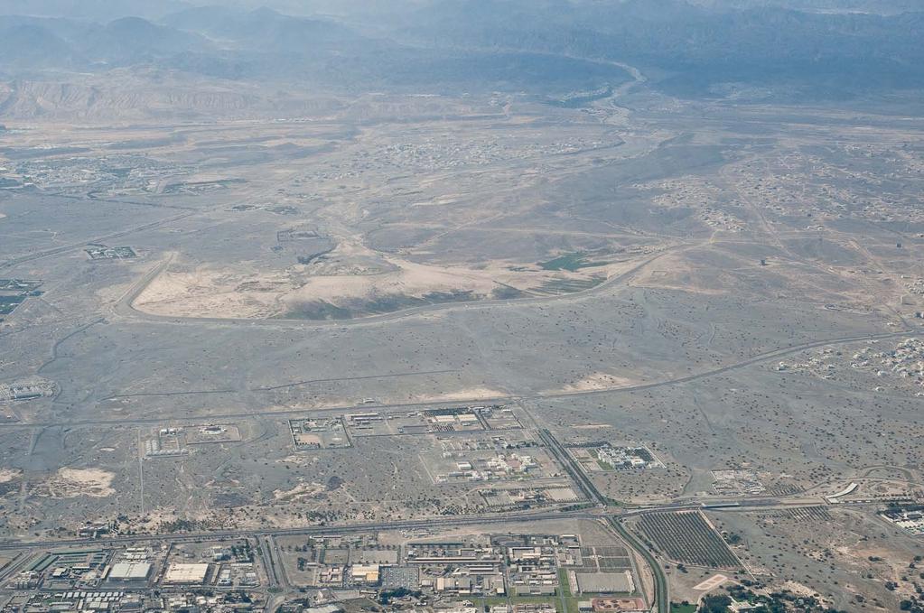
4 Oman The study Area


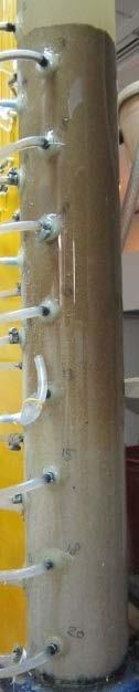
5 Methodology Residential area Abstraction wells Residential area Sampling (33-pedons)


")

6 Methodology (cont d) Physical Chemical & mineralogical Hydrological Soil Texture, Hydrometer Sand fractionation EC, ph and Cations (ICP) Calcimeter XRD SEM Infiltration tests (Tension infiltrometer) 7 selective tests

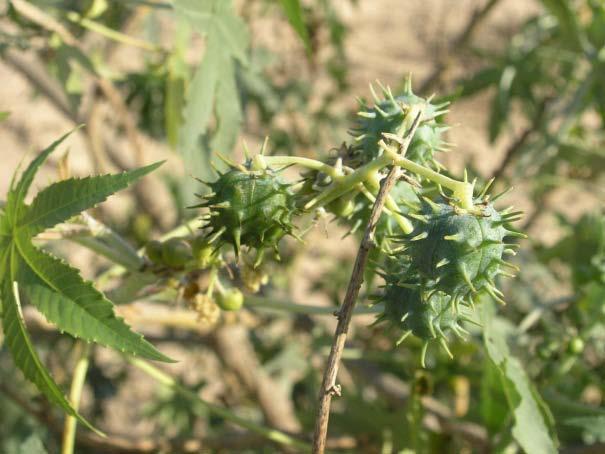
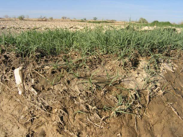
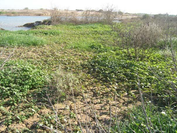


7 Scatters of different vegetative patterns in the lake area


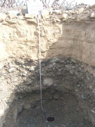


8 Soil Pedons of the Al-Khod Dam bed, 23 years after dam construction


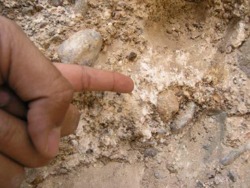
9 Incipient and mature pedogenic features of the study area.
10 Accumulated sediment analysis Suspended load will be quantified as Total Suspended Solids (mg/l) Bed load as the thickness of FSS (fine soil sediments silt + clay + very fine sand) deposition on soil surface A torrential rain event occurred in Muscat- Oman during the period 28 th April 3 rd May, 2013 which was an opportunity for this study


11 Suspended Load


12 Turbidity of the Wadi water High-velocity flow through the sluice gates and over the dam crest Sediments are reagitated and brought back into suspension flowing into the stilling basin and recharge basin
13


14 Bed Load Transect 1 was used to estimate the change in Al-Khoud dam water retention capacity It was estimated that > 30% of the storage volume was reduced since the dam construction Total volume that the dam can store is around 8 million m 3 instead of 11.7 million m 3

15 Wadi Hydrograph Source of Data : Ministry of Regional Municipalities and Water Resources

16 Translocation of FSS to subsurface soils Depends on soil texture, structure and pore size Physical clogging was observed and explored Likely, FSS vertically moved downward with the seeping water until particles are retained within pores

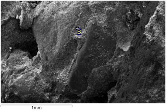
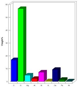
17 Mineralogical analysis XRD technique was used to quantify crystalline compounds in soil SEM was used in geochemical and mineral studies for the purpose of having closer inspection on the mineral surfaces, topography, morphology and composition Total 8 samples
 Higher coated")
 Denser soil")

18 Soil Density and Packing (Microscopic Scale) Higher coated matrix (Inside dam) Less coated matrix (Outside dam) Denser soil fabric with more packing/coating between the soil grains of soils inside the dam area.


19 Pedon E Ca E Mg Geogenic discontinuity Flicks of calcic materials (Field Observations) Ca Mg Petrographic Techniques


20 Vertical translocation of fine soil particles into the subsurface.
 x")


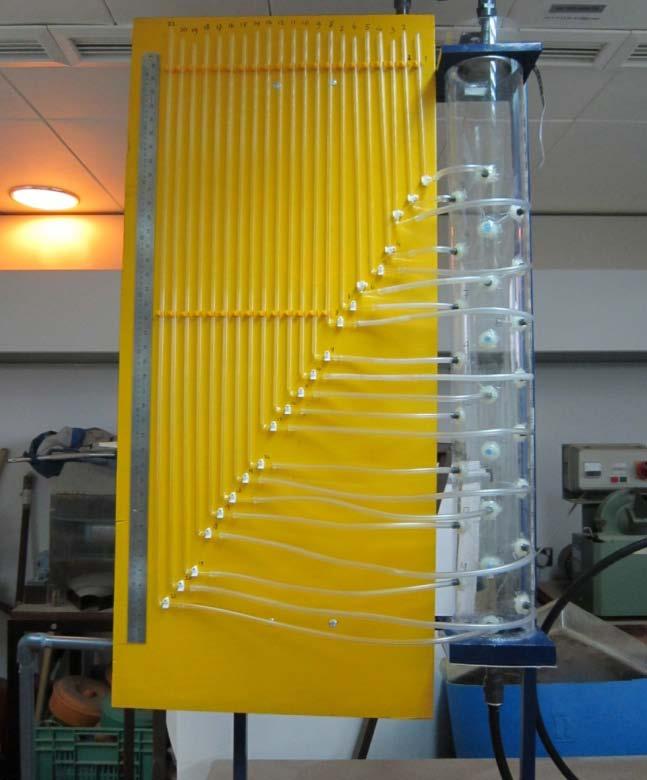
21 time (hour) x (cm)

22 M is accumulated mass of translocated particles in drained samples δ is mass of translocated particles in drained samples
23 Infiltration experiments Ks values of the selected pedons of the study area. Pedon Latitude Longitude Ks (m/day) Ks (cm/hr) AA AC AG I K O-surface O- (80 cm) R
24 Conclusions Reduction in storage capacity of recharge dams along with the obvious reduction in the infiltration rate of the reservoir bed, would results in more frequent over spilling of unclear water to recharge basin. Evolution of the physicalochemical characteristics of the subsurface soils in the vicinity of the recharge dams, affects its hydraulic properties that ultimately will deteriorate the recharge process. Presence of calcic materials coating at the bottom of rocks was observed at the pedological discontinuity with the soil horizons. This particle coating would grow with time resulting in chemical clogging The saturated hydraulic conductivity reduced by nearley 10 times when clogging take place (from both, field and column experiments)
25 Thank you
C) D) 3. Which graph best represents the relationship between soil particle size and the rate at which water infiltrates permeable soil?
 D) 3. Which graph best represents the relationship between soil particle size and the rate at which water infiltrates permeable soil?") 1. Which earth material covering the surface of a landfill would permit the least amount of rainwater to infiltrate the surface? A) silt B) clay C) sand D) pebbles 2. Which graph best represents the relationship
1. Which earth material covering the surface of a landfill would permit the least amount of rainwater to infiltrate the surface? A) silt B) clay C) sand D) pebbles 2. Which graph best represents the relationship
WATER ON AND UNDER GROUND. Objectives. The Hydrologic Cycle
 WATER ON AND UNDER GROUND Objectives Define and describe the hydrologic cycle. Identify the basic characteristics of streams. Define drainage basin. Describe how floods occur and what factors may make
 12 10 8 6 4 2 0 40-50 50-60 60-70 70-80 80-90 90-100 Fresh Water What we will cover The Hydrologic Cycle River systems Floods Groundwater Caves and Karst Topography Hot springs Distribution of water in
Soils, Hydrogeology, and Aquifer Properties. Philip B. Bedient 2006 Rice University
 Soils, Hydrogeology, and Aquifer Properties Philip B. Bedient 2006 Rice University Charbeneau, 2000. Basin Hydrologic Cycle Global Water Supply Distribution 3% of earth s water is fresh - 97% oceans 1%
5. Which surface soil type has the slowest permeability rate and is most likely to produce flooding? A) pebbles B) sand C) silt D) clay A) B) C) D)
 pebbles B) sand C) silt D) clay A) B) C) D)") 1. During a heavy rainstorm, soil samples A and B both became saturated with water. However, 10 minutes after the storm ended, the soils appeared as shown below. Which statement best explains the observed
1. During a heavy rainstorm, soil samples A and B both became saturated with water. However, 10 minutes after the storm ended, the soils appeared as shown below. Which statement best explains the observed
UGRC 144 Science and Technology in Our Lives/Geohazards
 UGRC 144 Science and Technology in Our Lives/Geohazards Flood and Flood Hazards Dr. Patrick Asamoah Sakyi Department of Earth Science, UG, Legon College of Education School of Continuing and Distance Education
Surface Processes Focus on Mass Wasting (Chapter 10)
") Surface Processes Focus on Mass Wasting (Chapter 10) 1. What is the distinction between weathering, mass wasting, and erosion? 2. What is the controlling force in mass wasting? What force provides resistance?
Surface Processes Focus on Mass Wasting (Chapter 10) 1. What is the distinction between weathering, mass wasting, and erosion? 2. What is the controlling force in mass wasting? What force provides resistance?
Sand Storage Dams Performance, cost-efficiency, working principles and constraints
 Copyright by Josep de Trincheria Copyright by Josep de Trincheria Copyright by Josep de Trincheria Copyright by Josep de Trincheria Sand Storage Dams Performance, cost-efficiency, working principles and
Summary. Streams and Drainage Systems
 Streams and Drainage Systems Summary Streams are part of the hydrologic cycle and the chief means by which water returns from the land to the sea. They help shape the Earth s surface and transport sediment
How & Where does infiltration work? Summary of Geologic History Constraints/benefits for different geologic units
 June 26, 2007: Low Impact Development 1 Associated Earth Sciences, Inc. Associated Earth Sciences, Inc. Presented by: Matthew A. Miller, PE April 24, 2012 How & Where does infiltration work? Summary of
Surface Water and Stream Development
 Surface Water and Stream Development Surface Water The moment a raindrop falls to earth it begins its return to the sea. Once water reaches Earth s surface it may evaporate back into the atmosphere, soak
Earth Science Chapter 6 Section 2 Review
 Name: Class: Date: Earth Science Chapter 6 Section Review Multiple Choice Identify the choice that best completes the statement or answers the question. 1. Most streams carry the largest part of their
GEOL 1121 Earth Processes and Environments
 GEOL 1121 Earth Processes and Environments Wondwosen Seyoum Department of Geology University of Georgia e-mail: seyoum@uga.edu G/G Bldg., Rm. No. 122 Seyoum, 2015 Chapter 6 Streams and Flooding Seyoum,
Laboratory Exercise #3 The Hydrologic Cycle and Running Water Processes
 Laboratory Exercise #3 The Hydrologic Cycle and Running Water Processes page - 1 Section A - The Hydrologic Cycle Figure 1 illustrates the hydrologic cycle which quantifies how water is cycled throughout
Groundwater from ophiolite aquifer: flow path and recharge rate
 Groundwater from ophiolite aquifer: flow path and recharge rate Rashid Al Abri 1,2, Osman Abdalla 2 and Khadija Semhi 2 1 Ministry of Regional Municipalities and Water Resources, Muscat, Oman 2 Dept. of
Groundwater Hydrology
 EXERCISE 12 Groundwater Hydrology INTRODUCTION Groundwater is an important component of the hydrologic cycle. It feeds lakes, rivers, wetlands, and reservoirs; it supplies water for domestic, municipal,
Introduction to Soil Science and Wetlands Kids at Wilderness Camp
 Introduction to Soil Science and Wetlands Kids at Wilderness Camp Presented by: Mr. Brian Oram, PG, PASEO B.F. Environmental Consultants http://www.bfenvironmental.com and Keystone Clean Water Team http://www.pacleanwater.org
' International Institute for Land Reclamation and Improvement. 2 Groundwater Investigations. N.A. de Ridder'? 2.1 Introduction. 2.
 2 Groundwater Investigations N.A. de Ridder'? 2.1 Introduction Successful drainage depends largely on a proper diagnosis of the causes of the excess water. For this diagnosis, one must consider: climate,
Chemistry of Tiling and Crusting
 Chemistry of Tiling and Crusting Tom DeSutter Assistant Professor of Soil Science NDSU Soil and Soil/Water Training 25 January 2012 What is Dispersion? Soil particles are repelled away from each other
HYDROGEOLOGICAL PROPERTIES OF THE UG2 PYROXENITE AQUIFERS OF THE BUSHVELD COMPLEX
 R. Gebrekristos, P.Cheshire HYDROGEOLOGICAL PROPERTIES OF THE UG2 PYROXENITE AQUIFERS OF THE BUSHVELD COMPLEX R. Gebrekristos Digby Wells Environmental P. Cheshire Groundwater Monitoring Services Abstract
This is start of the single grain view
 SOIL TEXTURE, PARTICLE SIZE DISTRIBUTION, SPECIFIC SURFACE AND CLAY MINERALS We will assess the physical realm of soil science in a piecewise fashion starting with the physical phases of soil, -- a single
6. Circle the correct answer: SINK A drains faster or SINK B drains faster Why?
 NAME date ROY G BIV Water Cycle and Water Movement in the Ground Test 5. 6. Circle the correct answer: SINK A drains faster or SINK B drains faster Why? 7. Circle the correct answer: SINK A retains more
Predicting the soil-water characteristics of mine soils
 Predicting the soil-water characteristics of mine soils D.A. Swanson, G. Savci & G. Danziger Savci Environmental Technologies, Golden, Colorado, USA R.N. Mohr & T. Weiskopf Phelps Dodge Mining Company,
Chapter 13. Groundwater
 Chapter 13 Groundwater Introduction Groundwater is all subsurface water that completely fills the pores and other open spaces in rocks, sediments, and soil. Groundwater is responsible for forming beautiful
Monday, October 15 th Grab a textbook! Objective: We will explain the formation of different soils and classify soils according to particle size.
 Soil Mr. Gilmore Monday, October 15 th Grab a textbook! Objective: We will explain the formation of different soils and classify soils according to particle size. Review: 1. The four limestone samples
Surface Water Short Study Guide
 Name: Class: Date: Surface Water Short Study Guide Multiple Choice Identify the letter of the choice that best completes the statement or answers the question. 1. The three ways in which a stream carries
Circle the correct (best) terms inside the brackets:
 terms inside the brackets:") 1 Circle the correct (best) terms inside the brackets: 1) Soils are [consolidated / unconsolidated] [natural / artificial] bodies at the earth s surface. Soils contain mineral and organic material, which
1 Circle the correct (best) terms inside the brackets: 1) Soils are [consolidated / unconsolidated] [natural / artificial] bodies at the earth s surface. Soils contain mineral and organic material, which
Groundwater Sustainability at Wadi Al Bih Dam, Ras El Khaimah, United Arab Emirates (UAE) using Geophysical methods
 using Geophysical methods") Groundwater Sustainability at Wadi Al Bih Dam, Ras El Khaimah, United Arab Emirates (UAE) using Geophysical methods Ahmed Murad, Amir Gabr, Saber Mahmoud, Hasan Arman & Abdulla Al Dhuhoori Geology Department
Groundwater Sustainability at Wadi Al Bih Dam, Ras El Khaimah, United Arab Emirates (UAE) using Geophysical methods Ahmed Murad, Amir Gabr, Saber Mahmoud, Hasan Arman & Abdulla Al Dhuhoori Geology Department
Effectiveness of Gabions Dams on Sediment Retention: A Case Study
 Journal of Environmental Science and Engineering A 5 (2016) 516-521 doi:10.17265/2162-5298/2016.10.004 D DAVID PUBLISHING Effectiveness of Gabions Dams on Sediment Retention: A Case Study Leandro Velázquez-Luna
Unsaturated Flow (brief lecture)
") Physical Hydrogeology Unsaturated Flow (brief lecture) Why study the unsaturated zone? Evapotranspiration Infiltration Toxic Waste Leak Irrigation UNSATURATAED ZONE Aquifer Important to: Agriculture (most
Physical Hydrogeology Unsaturated Flow (brief lecture) Why study the unsaturated zone? Evapotranspiration Infiltration Toxic Waste Leak Irrigation UNSATURATAED ZONE Aquifer Important to: Agriculture (most
Continuing Education Associated with Maintaining CPESC and CESSWI Certification
 Continuing Education Associated with Maintaining CPESC and CESSWI Certification Module 2: Stormwater Management Principles for Earth Disturbing Activities Sponsors: ODOTs Local Technical Assistance Program
Technical Review of Pak Beng Hydropower Project (1) Hydrology & Hydraulics and (2) Sediment Transport & River Morphology
 Hydrology & Hydraulics and (2) Sediment Transport & River Morphology") Technical Review of Pak Beng Hydropower Project (1) Hydrology & Hydraulics and (2) Sediment Transport & River Morphology The 2 nd Regional Stakeholder Forum The Pak Beng Hydropower Project 5 th May 2017
Technical Review of Pak Beng Hydropower Project (1) Hydrology & Hydraulics and (2) Sediment Transport & River Morphology The 2 nd Regional Stakeholder Forum The Pak Beng Hydropower Project 5 th May 2017
What we will cover. The Hydrologic Cycle. River systems. Floods. Groundwater. Caves and Karst Topography. Hot springs
 Fresh Water What we will cover The Hydrologic Cycle River systems Floods Groundwater Caves and Karst Topography Hot springs On a piece of paper, put these reservoirs of water in to order from largest to
International Journal for Management Science And Technology (IJMST)
") ISSN: 2320-8848 (Online) ISSN: 2321-0362 (Print) International Journal for Management Science And Technology (IJMST) Volume 3; Issue 6 Manuscript- 1 SUSPENDED SEDIMENT TRANSPORT FORMULA FOR THE UPSTREAM
ISSN: 2320-8848 (Online) ISSN: 2321-0362 (Print) International Journal for Management Science And Technology (IJMST) Volume 3; Issue 6 Manuscript- 1 SUSPENDED SEDIMENT TRANSPORT FORMULA FOR THE UPSTREAM
mountain rivers fixed channel boundaries (bedrock banks and bed) high transport capacity low storage input output
 high transport capacity low storage input output") mountain rivers fixed channel boundaries (bedrock banks and bed) high transport capacity low storage input output strong interaction between streams & hillslopes Sediment Budgets for Mountain Rivers Little
mountain rivers fixed channel boundaries (bedrock banks and bed) high transport capacity low storage input output strong interaction between streams & hillslopes Sediment Budgets for Mountain Rivers Little
Each basin is surrounded & defined by a drainage divide (high point from which water flows away) Channel initiation
 Channel initiation") DRAINAGE BASINS A drainage basin or watershed is defined from a downstream point, working upstream, to include all of the hillslope & channel areas which drain to that point Each basin is surrounded &
DRAINAGE BASINS A drainage basin or watershed is defined from a downstream point, working upstream, to include all of the hillslope & channel areas which drain to that point Each basin is surrounded &
Standards for Soil Erosion and Sediment Control in New Jersey May 2012
 STANDARD FOR SEDIMENT BASIN Definition A barrier, dam, excavated pit, or dugout constructed across a waterway or at other suitable locations to intercept and retain sediment. Basins created by construction
8. STATIC BARRIER EVALUATION
 8. STATIC BARRIER EVALUATION The construction of the barrier shown in Figure 5.3 permitted the sampling of water and measurement of ph at points along the entire length of each unit. Data on the variation
1. Water in Soils: Infiltration and Redistribution
 Contents 1 Water in Soils: Infiltration and Redistribution 1 1a Material Properties of Soil..................... 2 1b Soil Water Flow........................... 4 i Incorporating K - θ and ψ - θ Relations
Monday, Oct Field trip A1 & A2 signups: make sure you are where you think you should be
 Monday, Oct. 4 1. Field trip A1 & A2 signups: make sure you are where you think you should be 2. 5 credit people, field trip introduction in lab today 1. If you are unable to attend THIS SATURDAY, let
THE MINISTRY OF ENERGY AND ENERGY INDUSTRIES MINERALS DIVISION MINE DESIGN TEMPLATE OPERATOR NAME: OPERATOR ADDRESS: PHONE NUMBER: FACSIMILE:
 THE MINISTRY OF ENERGY AND ENERGY INDUSTRIES MINERALS DIVISION MINE DESIGN TEMPLATE 1.0 GENERAL INFORMATION OPERATOR NAME: OPERATOR ADDRESS: PHONE NUMBER: FACSIMILE: NAME OF CONTACT: CELLULAR PHONE: EMAIL
2 Development of a Physically Based Hydrologic Model of the Upper Cosumnes Basin
 2 Development of a Physically Based Hydrologic Model of the Upper Cosumnes Basin 2.1 Introduction The physically based watershed hydrologic model, WEHY (watershed environmental hydrology) model (Kavvas
Lecture Outlines PowerPoint. Chapter 5 Earth Science 11e Tarbuck/Lutgens
 Lecture Outlines PowerPoint Chapter 5 Earth Science 11e Tarbuck/Lutgens 2006 Pearson Prentice Hall This work is protected by United States copyright laws and is provided solely for the use of instructors
B-1. Attachment B-1. Evaluation of AdH Model Simplifications in Conowingo Reservoir Sediment Transport Modeling
 Attachment B-1 Evaluation of AdH Model Simplifications in Conowingo Reservoir Sediment Transport Modeling 1 October 2012 Lower Susquehanna River Watershed Assessment Evaluation of AdH Model Simplifications
MANAGEMENT IN TAIWAN
 RESERVOIR MANAGEMENT IN TAIWAN BY HSIAO-WEN WANG AND WEI-CHENG KUO With many dams reaching the end of their design life, sediment accumulation has become an increasingly important stake in reservoir management.
Estimation of Bed Load Transport in River Omi, South Western Nigeria using Grain Size Distribution Data
 International Journal of Engineering and Technology Volume 2 No. 9, September, 2012 Estimation of Bed Load Transport in River Omi, South Western Nigeria using Grain Size Distribution Data A.A. Adegbola
APPROACH TO THE SPANISH WATER ORGANISATION IMPROVING FLOOD HAZARD MAPPING, LAWS AND AUTHORITIES COORDINATION
 "Workshop On Land Use Planning And Water Management, With Focus On Flood Risk Management Oslo, Norway. Wednesday 31 January and Thursday 1 February 2007 APPROACH TO THE SPANISH WATER ORGANISATION IMPROVING
Do you think sediment transport is a concern?
 STREAM RESTORATION FRAMEWORK AND SEDIMENT TRANSPORT BASICS Pete Klingeman 1 What is Your Restoration Project Like? k? Do you think sediment transport is a concern? East Fork Lewis River, WA Tidal creek,
6.1 Water. The Water Cycle
 6.1 Water The Water Cycle Water constantly moves among the oceans, the atmosphere, the solid Earth, and the biosphere. This unending circulation of Earth s water supply is the water cycle. The Water Cycle
STUDY GUIDE FOR CONTENT MASTERY. Surface Water Movement
 Surface Water SECTION 9.1 Surface Water Movement In your textbook, read about surface water and the way in which it moves sediment. Complete each statement. 1. An excessive amount of water flowing downslope
Forest Hydrology: Lect. 9. Contents. Runoff, soil water and infiltration
 Forest Hydrology: Lect. 9 Contents Runoff, soil water and infiltration Learning objectives:. - Hillslope runoff generation processes; - Dynamics of runoff generation processes; - Hortonian and Dunnian
Prentice Hall EARTH SCIENCE
 Prentice Hall EARTH SCIENCE Tarbuck Lutgens Running Water and Groundwater Running Water The Water Cycle Water constantly moves among the oceans, the atmosphere, the solid Earth, and the biosphere. This
Remaining Capacity in Great Lakes Reservoirs
 US Army Corps of Engineers Detroit District Remaining Capacity in Great Lakes Reservoirs Storage Capacity Behind Great Lakes Dams Field Data and Modeling Motivation for project Project overview Data and
SPECIFIC DEGRADATION AND RESERVOIR SEDIMENTATION. By Renee Vandermause & Chun-Yao Yang
 SPECIFIC DEGRADATION AND RESERVOIR SEDIMENTATION By Renee Vandermause & Chun-Yao Yang Outline Sediment Degradation - Erosion vs Sediment Yield - Sediment Yield - Methods for estimation - Defining Sediment
DISTRIBUTION of WATER RESOURCES
 DAM GEOLOGY DISTRIBUTION of WATER RESOURCES Definition A dam is a structure which prevents the flow of water and accumulates it in a reservoir Karakaya Dam/Diyarbakır Atatürk Dam/Şanlıurfa Needs for Dam
The Hydrologic Cycle STREAM SYSTEMS. Earth s Water and the Hydrologic Cycle. The Hydrologic Cycle. Hydrologic Cycle
 STREAM SYSTEMS Earth Science: Chapter 5 Reading pages 114-124 The Hydrologic Cycle Oceans not filling up Evaporation = precipitation System is balanced Earth s Water and the Hydrologic Cycle Earth s Water
Cohesive sediment erosion and the Vectrino II. Peter J. Rusello DeFrees Hydraulics Laboratory Cornell University (also with NortekUSA)
") Cohesive sediment erosion and the Vectrino II Peter J. Rusello DeFrees Hydraulics Laboratory Cornell University (also with NortekUSA) http://www.flickr.com/photos/rabbit75/5191473522/ Images taken from
Cohesive sediment erosion and the Vectrino II Peter J. Rusello DeFrees Hydraulics Laboratory Cornell University (also with NortekUSA) http://www.flickr.com/photos/rabbit75/5191473522/ Images taken from
Rivers T. Perron
 1 Rivers T. Perron 12.001 After our discussions of large-scale topography, how we represent topography in maps, and how topography interacts with geologic structures, you should be frothing at the mouth
Why Study Groundwater?
 Groundwater Water filling open spaces in rock, sediment, and soil beneath the surface is called groundwater. This natural resource is as important to human endeavors as surface water. Groundwater is an
The generation and mobility of colloids in soils Production et mobilité des colloï des dans les sols
 Scientific registration n o : 1112 Symposium n o : 4 Presentation : poster The generation and mobility of colloids in soils Production et mobilité des colloï des dans les sols WATERS Angela, CHITTLEBOROUGH
Sedimentation in the Nile River
 Advanced Training Workshop on Reservoir Sedimentation Sedimentation in the Nile River Prof. Dr. Abdalla Abdelsalam Ahmed 10-16 Oct. 2007, IRTCES, Beijing, China CWR,Sudan 1 Water is essential for mankind
Topic 6: Weathering, Erosion and Erosional-Deposition Systems (workbook p ) Workbook Chapter 4, 5 WEATHERING
 Workbook Chapter 4, 5 WEATHERING") Topic 6: Weathering, Erosion and Erosional-Deposition Systems (workbook p. 95-125) Workbook Chapter 4, 5 THE BIG PICTURE: Weathering, erosion and deposition are processes that cause changes to rock material
Topic 6: Weathering, Erosion and Erosional-Deposition Systems (workbook p. 95-125) Workbook Chapter 4, 5 THE BIG PICTURE: Weathering, erosion and deposition are processes that cause changes to rock material
Lecture 7: Introduction to Soil Formation and Classification
 Lecture 7: Introduction to Soil Formation and Classification Soil Texture and Color Analysis Lab Results Soil A: Topsoil from Prof. Catalano s backyard Soil B: Soil above beach at Castlewood State Park
Hydrogeology of Karst NE Wisconsin. Dr. Maureen A. Muldoon UW-Oshkosh Geology Department
 Hydrogeology of Karst NE Wisconsin Dr. Maureen A. Muldoon UW-Oshkosh Geology Department WI Bedrock Outline Karst Landscapes Existing WQ Data Flow in Karst Aquifers Overview of Silurian Aquifer Water Level
Which map shows the stream drainage pattern that most likely formed on the surface of this volcano? A) B)
 B)") 1. When snow cover on the land melts, the water will most likely become surface runoff if the land surface is A) frozen B) porous C) grass covered D) unconsolidated gravel Base your answers to questions
1. When snow cover on the land melts, the water will most likely become surface runoff if the land surface is A) frozen B) porous C) grass covered D) unconsolidated gravel Base your answers to questions
Soils and Soil Minerals. Remember, most things can be too little or too much.
 Soils and Soil Minerals Remember, most things can be too little or too much. 1 2 3 Source of essential elements CO 2, O 2 from atmosphere H 2 0, O 2, minerals from soil NH 4, SO 4 can volatilize and be
Chemical Weathering and Soils
 Chemical Weathering and Soils Fresh rocks and minerals that once occupied the outermost position reached their present condition of decay through a complex of interacting physical, chemical, and biological
Advanced Hydraulics Prof. Dr. Suresh A Kartha Department of Civil Engineering Indian Institute of Technology, Guwahati
 Advanced Hydraulics Prof. Dr. Suresh A Kartha Department of Civil Engineering Indian Institute of Technology, Guwahati Module - 2 Uniform Flows Lecture - 6 Design of Channels for Uniform Flow (Refer Slide
Streams. Water. Hydrologic Cycle. Geol 104: Streams
 Streams Why study streams? Running water is the most important geologic agent in erosion, transportation and deposition of sediments. Water The unique physical and chemical properties of water make it
Geotechnical Properties of Soil
 Geotechnical Properties of Soil 1 Soil Texture Particle size, shape and size distribution Coarse-textured (Gravel, Sand) Fine-textured (Silt, Clay) Visibility by the naked eye (0.05 mm is the approximate
Mass Wasting. Requirements for Mass Wasting. Slope Stability. Geol 104: mass wasting
 Mass Wasting Movement of earth materials downslope, driven by Gravitational Forces. Landslides - general term for rock or soil movement. In U.S., on average, mass wasting causes 1 to 2 billion dollars
Essentials of Geology, 11e
 Essentials of Geology, 11e Groundwater Chapter 10 Instructor Jennifer Barson Spokane Falls Community College Geology 101 Stanley Hatfield Southwestern Illinois Co Jennifer Cole Northeastern University
STREAM SYSTEMS and FLOODS
 STREAM SYSTEMS and FLOODS The Hydrologic Cycle Precipitation Evaporation Infiltration Runoff Transpiration Earth s Water and the Hydrologic Cycle The Hydrologic Cycle The Hydrologic Cycle Oceans not filling
Precipitation Evaporation Infiltration Earth s Water and the Hydrologic Cycle. Runoff Transpiration
 STREAM SYSTEMS and FLOODS The Hydrologic Cycle Precipitation Evaporation Infiltration Earth s Water and the Hydrologic Cycle Runoff Transpiration The Hydrologic Cycle The Hydrologic Cycle Oceans not filling
River Response. Sediment Water Wood. Confinement. Bank material. Channel morphology. Valley slope. Riparian vegetation.
 River Response River Response Sediment Water Wood Confinement Valley slope Channel morphology Bank material Flow obstructions Riparian vegetation climate catchment vegetation hydrological regime channel
Geology 229 Engineering Geology. Lecture 7. Rocks and Concrete as Engineering Material (West, Ch. 6)
") Geology 229 Engineering Geology Lecture 7 Rocks and Concrete as Engineering Material (West, Ch. 6) Outline of this Lecture 1. Rock mass properties Weakness planes control rock mass strength; Rock textures;
Geology 229 Engineering Geology Lecture 7 Rocks and Concrete as Engineering Material (West, Ch. 6) Outline of this Lecture 1. Rock mass properties Weakness planes control rock mass strength; Rock textures;
Jim Turenne. Soils on Social Media
 Jim Turenne USDA-NRCS 60 Quaker Lane, Suite 46 Warwick, RI. 02886 401-822-8832 Jim.turenne@ri.usda.gov Soils on Social Media www.twitter.com/soilsne www.fb.com/soilsne www.nesoil.com U.S. Department of
Chapter 3 Sedimentation of clay minerals
 Chapter 3 Sedimentation of clay minerals 3.1 Clay sedimentation on land 3.2 From land to sea 3.3 Clay sedimentation in the sea 1 3.1 Clay sedimentation on land Deserts Glaciers Rivers Lacustrine 2 University
Lower Susquehanna River Integrated Sediment & Nutrient Monitoring Program
 Lower Susquehanna River Integrated Sediment & Nutrient Monitoring Program Presented at the Chesapeake Bay Program Scientific and Technical Advisory Committee (STAC) Workshop January 13, 2016 Background
NATURAL RIVER. Karima Attia Nile Research Institute
 NATURAL RIVER CHARACTERISTICS Karima Attia Nile Research Institute NATURAL RIVER DEFINITION NATURAL RIVER DEFINITION Is natural stream of water that flows in channels with ih more or less defined banks.
CASE STUDY NATHPA JHAKRI, INDIA
 SEDIMENT MANAGEMENT CASE STUDY NATHPA JHAKRI, INDIA Key project features Name: Nathpa Jhakri Country: India Category: reforestation/revegetation; upstream sediment trapping; bypass channel/tunnel; reservoir
Landslides and Ground Water Permeability with Respect to the. Contact Point of Glacial Lake Vermont and the Champlain Sea
 Landslides and Ground Water Permeability with Respect to the Contact Point of Glacial Lake Vermont and the Champlain Sea Sediments at Town Line Brook, Winooski, VT Michala Peabody Lara Vowles Abstract:
Erosion Surface Water. moving, transporting, and depositing sediment.
 + Erosion Surface Water moving, transporting, and depositing sediment. + Surface Water 2 Water from rainfall can hit Earth s surface and do a number of things: Slowly soak into the ground: Infiltration
ENGINEERING HYDROLOGY
 ENGINEERING HYDROLOGY Prof. Rajesh Bhagat Asst. Professor Civil Engineering Department Yeshwantrao Chavan College Of Engineering Nagpur B. E. (Civil Engg.) M. Tech. (Enviro. Engg.) GCOE, Amravati VNIT,
Primary Structures in Sedimentary Rocks. Engr. Sultan A. Khoso
 Primary Structures in Sedimentary Rocks Engr. Sultan A. Khoso Sedimentary rocks Sedimentary rocks are those rocks which are formed by the weathered sediments of pre existing rocks (igneous or metamorphic
Infiltration Characteristics of Granitic Residual Soil of Various Weathering Grades
 American Journal of Environmental Sciences (): 64-68, 25 ISSN 553-345X Science Publications, 25 Infiltration Characteristics of Granitic Residual Soil of Various Weathering Grades Faisal Hj. Ali, 2 Bujang
THE CHANGING SURFACE OF THE EARTH
 THE CHANGING SURFACE OF THE EARTH Key words Drain geological agent weathering erosion Sediment deposition transport The landscape is a consequence of the action of two types of geological processes; internal
Lab 2: Slope Aspect Lab
 Lab : Slope Aspect Lab Objectives: to investigate potential differences between north- and south-facing slopes in the foothills of the Colorado Front Range to become familiar with the US Geological Survey
Cuyama Basin North Fork Vineyard
 Cuyama Basin North Fork Vineyard Company Background plus Data Insights to Support GSP Development for the Cuyama Basin Presented by Grapevine Capital Partners and Cleath-Harris Geologists April 26th, 2018
SCOPE OF PRESENTATION STREAM DYNAMICS, CHANNEL RESTORATION PLANS, & SEDIMENT TRANSPORT ANALYSES IN RELATION TO RESTORATION PLANS
 DESIGN METHODS B: SEDIMENT TRANSPORT PROCESSES FOR STREAM RESTORATION DESIGN PETER KLINGEMAN OREGON STATE UNIVERSITY CIVIL ENGINEERING DEPT., CORVALLIS 2 ND ANNUAL NORTHWEST STREAM RESTORATION DESIGN SYMPOSIUM
Influence of the Major Drainages to the Mississippi River and Implications for System Level Management
 Influence of the Major Drainages to the Mississippi River and Implications for System Level Management Brian M. Vosburg Geologist Louisiana Coastal Protection and Restoration Authority brian.vosburg@la.gov
Mark S. Nordberg Geology and Groundwater Investigations Section North Central Region Office California Department of Water Resources
 Mark S. Nordberg Geology and Groundwater Investigations Section North Central Region Office California Department of Water Resources Ukiah Drought Workshop July 29, 2009 Groundwater 101 Groundwater is
Land subsidence due to groundwater withdrawal in Hanoi, Vietnam
 Land Subsidence (Proceedings of the Fifth International Symposium on Land Subsidence, The Hague, October 1995). 1AHS Publ. no. 234, 1995. 55 Land subsidence due to groundwater withdrawal in Hanoi, Vietnam
GROUNDWATER MEGA PACKET
 NAME GROUNDWATER MEGA PACKET 1. The diagram below shows columns A, B, C, and D that contain different sediments. Equal volumes of water were poured through each column. Which column of sediment retained
The physical breakdown and chemical alteration of rocks and minerals at or near Earth s surface.
 The physical breakdown and chemical alteration of rocks and minerals at or near Earth s surface. The material that is chemically and mechanically weathered to yield sediment and soil. Regolith consisting
Numerical modeling of sediment flushing from Lewis and Clark Lake
 University of Nebraska - Lincoln DigitalCommons@University of Nebraska - Lincoln US Army Research U.S. Department of Defense 2013 Numerical modeling of sediment flushing from Lewis and Clark Lake Jungkyu
Laboratory Exercise #4 Geologic Surface Processes in Dry Lands
 Page - 1 Laboratory Exercise #4 Geologic Surface Processes in Dry Lands Section A Overview of Lands with Dry Climates The definition of a dry climate is tied to an understanding of the hydrologic cycle
Internet Interactive Rock Cycle
 Internet Interactive Rock Cycle Directions: Go to the website http://www.uky.edu/as/geology/howell/goodies/elearning/module05swf.swf and answer the questions below. Part I: Igneous Rocks (click on Igneous
Course Scheme -UCE501: SOIL MECHANICS L T P Cr
 Course Scheme -UCE501: SOIL MECHANICS L T P Cr 3 1 2 4.5 Course Objective: To expose the students about the various index and engineering properties of soil. Introduction: Soil formation, various soil
Calculating the suspended sediment load of the Dez River
 Erosion and Sediment Transport Monitoring Programmes in River Basins (Proceedings of the Osio Symposium, August 1992). IAHS Publ. no. 210, 1992. 219 Calculating the suspended sediment load of the Dez River