Sand Storage Dams Performance, cost-efficiency, working principles and constraints
|
|
|
- Elwin Hopkins
- 5 years ago
- Views:
Transcription


 9")
1 Copyright by Josep de Trincheria Copyright by Josep de Trincheria Copyright by Josep de Trincheria Copyright by Josep de Trincheria Sand Storage Dams Performance, cost-efficiency, working principles and constraints De Trincheria, Josep, Hamburg University of Technology, Germany Nissen-Petersen, Erik ASAL Consultants Ltd, Kenya International Symposium on RWH in Ethiopia (ISRH) 9 th June 2015

2 2 Outline 1. Rationale 2. Study area 3. Methodology s Results s Results 6. Causes and factors Source: 7. Practical recommendations
3 3 1. Rationale To implement sand dams showing satisfactory performance and cost-efficiency levels is a complex procedure There are key biophysical and technical constraints which limit their real-life performance and cost-efficiency Currently, these biophysical factors and technical constraints are not adequately understood

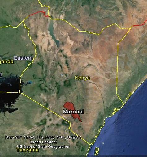
4 2. Study Area 4

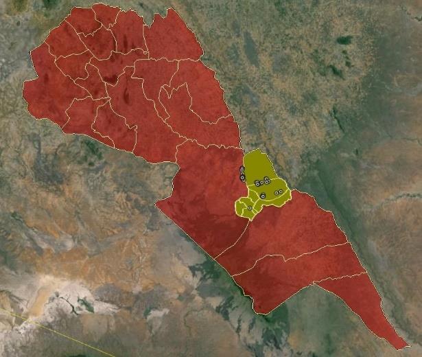
5 2. Study Area: All sand dams evaluated 5
6 6 3. Methodology 2012: 31 SDs evaluated - On-the-ground physical survey - Geometrical factor, throwback; bimodal rainfall season; evaporation and seepage losses; baseflow from riverbanks; specific yield - Sand storage capacity; Yearly water yield; Supply capacity; Cost-Efficiency - Semi-structured interviews with direct beneficiaries 2015: 48 SDs evaluated (incl s) - Identification sediment texture and spillway damage - Semi-structured interviews with direct beneficiaries water supply capacity during the dry season
7 s results 7
8 s Results: water supply during the dry season 8
9 Households Months s Results: water supply during the dry season Water supply capacity during the dry season (households) Water supply capacity during the dry season (months) 6% were supplying water during the dry season
10 s Results: Sand sediments 10


11 s Results: Sand sediments Sediments Coarse, 0% Soil, 6% Fine, 10% Silt, 42% Medium, 25% None, 17% 65% were not effectively accumulating sand sediments None were accumulating coarse sand sediments Medium and fine sand sediments were present in 35% of the SDs
12 s Results: Damaged sand dams 12


13 s Results: Damaged sand dams Robustness Wingwall 4% Leakage 6% Swept away 17% Spillway 2% None 71% 29% showed severe structural damages: washed away, leakage, wing walls, spillway
14 s results 14
15 2. Study Area: Evaluations in 2012 and
16 Volume of sand (m3) Sand storage capacity 8,000 Potential sand storage capacity 7,000 6,000 5,000 4,000 3,000 2,000 1,000 0 Sand storage dam identification 83% presented volumes of sand <1000 m3 7% of the SDs accumulated 58% Upper layers of highly mixed sandy, silty and clayey sediments Upper layers of silty and/or clayey sediments on top of a layer of sandy sediments

17 5.1 Sand storage capacity

18 5.1 Sand storage capacity

19 5.1 Sand storage capacity

20 5.1 Sand storage capacity 20
21 Specific yield of the reservoirs 35.00% 30.00% 35.00% 25.00% 20.00% 15.00% 10.00% 6.67% 5.38% 6.92% 7.14% 8.46% 20.00% 15.00% 10.00% 5.00% 3.00% 0.00% Average specific yield 6.9% 7 [3,12]% is the specific yield for silty and sandy clay alluvium sediments 5 times lower than 35% Cause: High proportions of silty and clayey particles in the reservoirs
22 Water stored in the sand Water in sand sediments No water (93%) Water (7%) 80% acted as conventional dams Surface water between 0,5-3 months after the rainy season
23 m3/year Yearly water yield 2,000 1,800 1,600 1,400 1,200 1, Yield Yield seepage losses Yield evaporation Yield contribution riverbanks The average yields were 112 m 3 /year Total aggregated yield for the 30 SDs= - < 2 x higher minimum yield 1 SD - 6% of its minimum satisfactory capacity - 2 SDs responsible for 56% of the water yield Cause: low volumes of sand sediments + low specific yields
24 Losses (%) 26.05% Evaporation % 90.00% 80.00% 70.00% 60.00% 50.00% 40.00% 30.00% 20.00% 10.00% 0.00% % evaporation losses actual Evaporation and seepage losses were 50% High vulnerability to evaporation generalised shallowness of the reservoirs High depth of sediments is crucial Evaporation may uniformly affect at least the first 60 cm of coarse sand reservoirs
25 N households/dry season Water supply capacity Actual Evap H Actual Evap C Actual Riv H Actual Riv C Total aggregated supply capacity was 64 and 39 households This is 320 and 195 individuals 17,000 inhabitants in the entire study area 660 inhabitants is the typical village size The supply capacity may decrease during poor rainfall years and droughts when the study area may shift to only one rainy season per year Low resilience to poor rainfall years and droughts
26 EUR Construction costs 22, , ,313 17, , , , , , , Total costs EUR 241,899 Average costs EUR 8,639/SD [EUR 414,672 for 48 SDs] 5 times higher from than Low spillways, rubble stone masonry, low construction volumes High spillways, reinforced rubble stone masonry, high construction volumes
27 EUR/m Cost-efficiency: Yearly water yield 22, , , Actual cost-efficiency evaporation Actual cost-efficiency contribution Costs 17,570 15, , , , , , Average 5,402 EUR/m3 EUR 134,830 were invested in SDs producing yearly yields lower than 1 m3/year
28 EUR/household Cost-efficiency: Water supply capacity 22,500 20,000 17,500 Actual average Hot Actual average Cold Costs 22,313 15,000 12,500 10,000 7,500 5, , Average cost-efficiency was 6,768 EUR/household Between EUR 167,715 and 190,425 did not supply water to any household (70-78% of the total investment)
29 6. Causes and factors 29
30 6.1 Incorrect siting procedure Reservoirs with low volumes of coarse sand 30
31 Incorrect siting: Reservoirs with fine sand Specific yield of fine sand is 21 [28, 10]% well-sorted, lab conditions However: - Low sorting degree levels Ill sorted fine sand is 13 [25, 4]% - Layers of finer alluvium sediments (interbedding) - Partial saturation of the reservoirs during the first 5-10 years (Wipplinger, 1958) - Partial saturation during poor rainfall years and droughts Real-life specific yield of fine sand lower than 10% Higher probability of low performance and cost-efficiency levels in fine sandy reservoirs Not suitable sites


32 Incorrect siting: Reservoirs with fine sand
33 6.3 Incorrect siting: Reservoirs with silty and/or clayey sediments 33

34 6.3 Incorrect siting: Reservoirs with silty and/or clayey sediments 34

35 6.3 Incorrect siting: Reservoirs with silty and/or clayey sediments 35

36 6.3 Incorrect siting: Reservoirs with silty and/or clayey sediments 36


37 Incorrect siting: Reservoirs with silty and/or clayey sediments
38 6.3 Incorrect siting: Reservoirs with silty and/or clayey sediments 38
39 6.4 Incorrect siting: Seepage losses 39

40 6.4 Incorrect siting: Seepage losses 40

41 6.4 Incorrect siting: Seepage losses 41

42 6.4 Incorrect siting: Seepage losses 42

43 6.4 Incorrect siting: Seepage losses 43
44 Evaporation losses Evaporation may have been undervalued and should be systematically taken into account 10% at 60 cm, 0% at 0,9-1,0 m, but for coarse sand sediments Higher depths with fine sand, and silty and clayey sediments! Shallow reservoirs are vulnerable evaporation up to 0,6 m along all the surface!
45 Incorrect structural design: One-stage high spillways Design principle: Maximise the accumulation of coarse sand Height of the spillway is a key parameter adequate flood velocities allowing deposition of sand sediments in as much different biophysical, rainfall, runoff and sediment transport conditions as possible Lower probability of deposition of fine grain-size sediments Avoid reservoirs formed by mixtures of coarse sand mixed with finer sediments low specific yield
46 Incorrect structural design: One-stage high spillways Solution: Build the spillway by stages of reduced height (-) Not adequate infiltration need to be taken into account (-) Construction time and higher costs for rivers with continuous water flow during the rainy season (intermittent) (+) Maximisation of the performance and cost-efficiency, robustness to variability of rainfall, flow and sediment transport

47 Incorrect siting: Reservoirs with silty and/or clayey sediments All sizes of silty, clayey, sandy and gravel alluvium sediments. Silt- and clay-like particles as suspended load at upper part of the water column. Heavier sand and gravel particles as bedload at the lower part of the flood water
48 6.3 Incorrect siting: Reservoirs with silty and/or clayey sediments 48


49 49 Source: Nilsson, Incorrect structural design: One-stage high spillways
50 Incorrect structural design: One-stage high spillways There are sand dams built in one stage with no apparent siltation problems Catchment areas producing large volumes of sand sediments and/or highly specific rainfall, runoff and sediment transport conditions However, it should not be assumed that these highly specific conditions are applicable to other areas Even in these cases, there is a high probability that the performance and cost-efficiency is not maximum - Variability of rainfall, sediment and runoff - Forced interbedding - Non-selective scouring - Maturity paradox


51 Incorrect structural design: Variability of the rainfall, runoff and sediment transport Annual rainfall at Dwa plantation in Kibwezi, Seasonal rainfall variability at Dw plantation in Kibwezi, Ten-year distribution of good, normal and poor rainfall years in Kibwezi
52 Incorrect structural design: Forced interbedding Construction of one-stage high spillways Higher probability to block the bedload and suspended load Production of normally graded-bedded reservoirs The expected water yield of the sand dam may be assumed to be much lower than the real-life water yield of the reservoir In Keren (Eritrea), one-stage high spillways have been systematically built in catchment areas producing large volumes of coarse sand The reservoirs showed a layer of at least 1 m of silty alluvium sediments below a layer of sandy alluvium sediment of 3 m depth

53 Incorrect structural design: Forced interbedding Systematic change in grain or size from the base of the bed to the top Normal grading with coarser sediments at the base, which grade upward into progressively finer ones
54 Incorrect structural design: Selective scouring of fine grain-size sediments Subsequent floods should not be assumed to systematically wash away fine sediments and leave the coarsest ones The selective scouring of fine grain-size alluvium sediments depends on the energy of the river flow The energy of the river flow is highly variable inherent extreme temporal and spatial variability of rainfall, flood and sediment transport The stage height reduces the energy of the river flow and makes it vulnerable to accumulate fine sediments in a wider range of conditions The depth of the fine grain-size sediments accumulated causes that the energy required to effectively scour is higher As higher the stage height, the lower the probability that the river flow will have the required energy to effectively scour silty and clayey sediments
55 Incorrect structural design: maturity paradox Towards the end of the filling up of the SDs built as one-stage high spillways Spillway height will always have the adequate height to only retain the coarsest bedload sediments The velocity of the flow has been increased as a result of shallower water depth (as it is intended by stages) Independently of the actual distribution of sediments in the reservoir, it will always appear to be homogenously filled up with sandy alluvium sediments Reservoir will be wrongly assumed to be mature The real-life specific yield may be significantly lower as expected low performance and cost-efficiency
56 7. Practical recommendations 56
57 7.1 Practical recommendations: Systematic siting procedure 57
58 Practical recommendations: Real-life specific yield Specific yield analysis of representative sediments in the reservoir should always be systematically carried out In the absence of those: It is recommended to use 20-25% as the reference maximum specific yield of coarse sand reservoirs


59 6.6 Incorrect structural design: One-stage high spillways Stage 1. Spillway is 50 cm above the sand level Stage 2. Flood has brought sand to the level of the spillway Stage 3. Spillway is raised to 50 cm above new sand level Stage 4. Flood has deposited sand to the new level of the spillway Stage 5. Spillway is raised to 50 cm above new sand level Stage 6. This procedure is repeated until the spillway is fully closed 59
60 Practical recommendations: Height of the stages Without an adequate evaluation of the bedload and suspended load characteristics, the precautionary height of cm - 18 cm high proportions of fine alluvium sediments - 50 cm high proportions of coarse sandy alluvium sediments. The height of the stage should be adapted to the most probable minimum flow, i.e. the minimum height of the bedload Only after an evaluation of the rainfall, runoff and sediment transport, the implementation of higher stage heights may be possible
61 Practical recommendations: Multi-stage construction Even by stages, 100% perfection cannot be achieved with smallest floods the velocity of flow may always be low enough for the deposition of fine grain-size sediments of reduced specific yield. Spillways by stages according to the most probable flood SDs accumulating silty and clayey alluvium sediments during poor rainfall years and droughts. High spillways in one stage systematic accumulation of large volumes of fine grain-size sediments low performance and cost-efficiency
62 Practical recommendations: Naturally deep layers of sand sediments and/or alluvial aquifers
63 Practical recommendations: Increase storage capacity Clear relationship between the capacity of a dam and the spillway height. Direct impact on the construction costs and costefficiency, technical complexity and the robustness of the structure Need to take into account other relevant factors: - The slope of the riverbed and its effect on the throwback - The texture and depth of the sediments of the original riverbed free sand storage capacity and robustness to evaporation Higher specificity of suitable sites Lower replicability and transfer potential
64 Practical recommendations: Other alternatives Other rainwater harvesting storage technologies may show higher levels of performance and/or cost-efficiency Sub-surface dams, earth dams, ponds, etc.
65 Thank you for your attention! 65
66 Copyright by Josep de Trincheria Copyright by Josep de Trincheria Copyright by Josep de Trincheria Copyright by Josep de Trincheria Sand Storage Dams Performance, cost-efficiency, working principles and constraints De Trincheria, Josep, Hamburg University of Technology, Germany Nissen-Petersen, Erik ASAL Consultants Ltd, Kenya International Symposium on RWH in Ethiopia (ISRH) 9 th June 2015
6. Circle the correct answer: SINK A drains faster or SINK B drains faster Why?
 NAME date ROY G BIV Water Cycle and Water Movement in the Ground Test 5. 6. Circle the correct answer: SINK A drains faster or SINK B drains faster Why? 7. Circle the correct answer: SINK A retains more
[1] Performance of the sediment trap depends on the type of outlet structure and the settling pond surface area.
![[1] Performance of the sediment trap depends on the type of outlet structure and the settling pond surface area.](/thumbs/76/74245181.jpg "[1] Performance of the sediment trap depends on the type of outlet structure and the settling pond surface area.") Sediment Trench SEDIMENT CONTROL TECHNIQUE Type 1 System Sheet Flow Sandy Soils Type 2 System [1] Concentrated Flow Clayey Soils Type 3 System [1] Supplementary Trap Dispersive Soils [1] Performance of
Sediment Trench SEDIMENT CONTROL TECHNIQUE Type 1 System Sheet Flow Sandy Soils Type 2 System [1] Concentrated Flow Clayey Soils Type 3 System [1] Supplementary Trap Dispersive Soils [1] Performance of
Sedimentation in the Nile River
 Advanced Training Workshop on Reservoir Sedimentation Sedimentation in the Nile River Prof. Dr. Abdalla Abdelsalam Ahmed 10-16 Oct. 2007, IRTCES, Beijing, China CWR,Sudan 1 Water is essential for mankind
HYDROPEDOLOGY AND WATER RESOURCES MANAGEMENT: CASE STUDY OF AL-KHOUD RECHARGE DAM- OMAN
 HYDROPEDOLOGY AND WATER RESOURCES MANAGEMENT: CASE STUDY OF AL-KHOUD RECHARGE DAM- OMAN Dr. Ali Al-Maktoumi Sultan Qaboos University, Oman Gulf Water Conference 11 th 20-22 October 2014 Co-authors: Al-Saqri,
River bank erosion risk potential with regards to soil erodibility
 River Basin Management VII 289 River bank erosion risk potential with regards to soil erodibility Z. A. Roslan 1, Y. Naimah 1 & Z. A. Roseli 2 1 Infrastructure University, Kuala Lumpur, Malaysia 2 Humid
C) D) 3. Which graph best represents the relationship between soil particle size and the rate at which water infiltrates permeable soil?
 D) 3. Which graph best represents the relationship between soil particle size and the rate at which water infiltrates permeable soil?") 1. Which earth material covering the surface of a landfill would permit the least amount of rainwater to infiltrate the surface? A) silt B) clay C) sand D) pebbles 2. Which graph best represents the relationship
1. Which earth material covering the surface of a landfill would permit the least amount of rainwater to infiltrate the surface? A) silt B) clay C) sand D) pebbles 2. Which graph best represents the relationship
Tikrit University College of Engineering Civil engineering Department
 Tikrit University SOIL CLASSIFICATION College of Engineering Civil engineering Department Soil Mechanics 3 rd Class Lecture notes Up Copyrights 2016 Classification of soil is the separation of soil into
Strategies for managing sediment in dams. Iwona Conlan Consultant to IKMP, MRCS
 Strategies for managing sediment in dams Iwona Conlan Consultant to IKMP, MRCS 1 Sediment trapping by dams Active storage capacity Dead storage coarse material (bed load) Fine materials (suspension) Francis
Soil Formation. Lesson Plan: NRES B2-4
 Soil Formation Lesson Plan: NRES B2-4 1 Anticipated Problems 1. What are five different factors that affect soil formation? 2. What are some different types of parent material that affect soils? 3. What
Lower Susquehanna River Integrated Sediment & Nutrient Monitoring Program
 Lower Susquehanna River Integrated Sediment & Nutrient Monitoring Program Presented at the Chesapeake Bay Program Scientific and Technical Advisory Committee (STAC) Workshop January 13, 2016 Background
Land subsidence due to groundwater withdrawal in Hanoi, Vietnam
 Land Subsidence (Proceedings of the Fifth International Symposium on Land Subsidence, The Hague, October 1995). 1AHS Publ. no. 234, 1995. 55 Land subsidence due to groundwater withdrawal in Hanoi, Vietnam
CHAPTER 07 CANAL DESIGN
 CHAPTER 07 CANAL DESIGN Dr. M. R. Kabir Professor and Head, Department of Civil Engineering University of Asia Pacific (UAP), Dhaka LECTURE 17 Canal Design Types Canal Design Drainage Channel Design Irrigation
Analysis of Sedimentation in Wonogiri Reservoir
 Journal of the Civil Engineering Forum Vol. 2 No. 1 (January 2016) Analysis of Sedimentation in Wonogiri Reservoir Tri Joko Inti Budi Santosa Large River Basin Organization of Bengawan Solo, Surakarta,
Rock & Aggregate Drop Inlet Protection
 Rock & Aggregate Drop Inlet Protection SEDIMENT CONTROL TECHNIQUE Type 1 System Sheet Flow Sandy Soils Type 2 System [1] Concentrated Flow Clayey Soils Type 3 System Supplementary Trap Dispersive Soils
(3) Sediment Movement Classes of sediment transported
 Sediment Movement Classes of sediment transported") 9/17/15 (3) Sediment Movement Classes of sediment transported Dissolved load Suspended load Important for scouring algae Bedload (5-10% total load) Moves along bed during floods Source of crushing for
9/17/15 (3) Sediment Movement Classes of sediment transported Dissolved load Suspended load Important for scouring algae Bedload (5-10% total load) Moves along bed during floods Source of crushing for
Experimental Study of the Sediment Trap Effect of Steel Grid-Type Sabo Dams
 Experimental Study of the Sediment Trap Effect of Steel Grid-Type Sabo Dams Teruyoshi TAKAHARA 1 and Kazuki MATSUMURA 1 1 Graduate school of Agriculture, Kyoto Pref. University (1-5 Shimogamonakaragicyo,
STREAM SYSTEMS and FLOODS
 STREAM SYSTEMS and FLOODS The Hydrologic Cycle Precipitation Evaporation Infiltration Runoff Transpiration Earth s Water and the Hydrologic Cycle The Hydrologic Cycle The Hydrologic Cycle Oceans not filling
Precipitation Evaporation Infiltration Earth s Water and the Hydrologic Cycle. Runoff Transpiration
 STREAM SYSTEMS and FLOODS The Hydrologic Cycle Precipitation Evaporation Infiltration Earth s Water and the Hydrologic Cycle Runoff Transpiration The Hydrologic Cycle The Hydrologic Cycle Oceans not filling
Enhanced Characterization of the Mississippi River Valley Alluvial Aquifer Using Surface Geophysical Methods
 Photo by Shane Stocks, U.S. Geological Survey Enhanced Characterization of the Mississippi River Valley Alluvial Aquifer Using Surface Geophysical Methods Presented by Ryan F. Adams US Geological Survey
Bishopville Prong Study
 Bathymetric and Sediment Assessment in the Bishopville Prong of St. Martin River Darlene V. Wells, Richard A. Ortt, Jr., and Stephen Van Ryswick Funded by MCBP 2011-2012 Implementation Grant Objectives
The effectiveness of check dams in controlling upstream channel stability in northeastern Taiwan
 Erosion, Debris Mows and Environment in Mountain Regions (Proceedings of the Chengdu Symposium, July 1992). IAHS Publ. no. 209, 1992. 423 The effectiveness of check dams in controlling upstream channel
Effectiveness of Gabions Dams on Sediment Retention: A Case Study
 Journal of Environmental Science and Engineering A 5 (2016) 516-521 doi:10.17265/2162-5298/2016.10.004 D DAVID PUBLISHING Effectiveness of Gabions Dams on Sediment Retention: A Case Study Leandro Velázquez-Luna
Lab 7: Sedimentary Structures
 Name: Lab 7: Sedimentary Structures Sedimentary rocks account for a negligibly small fraction of Earth s mass, yet they are commonly encountered because the processes that form them are ubiquitous in the
Do you think sediment transport is a concern?
 STREAM RESTORATION FRAMEWORK AND SEDIMENT TRANSPORT BASICS Pete Klingeman 1 What is Your Restoration Project Like? k? Do you think sediment transport is a concern? East Fork Lewis River, WA Tidal creek,
Artificial Recharge to Alluvial Aquifer, Northeastern Nuba Mountains, Sudan.
 International Journal of Research in Engineering and Science (IJRES) ISSN (Online): 2320-9364, ISSN (Print): 2320-9356 Volume 3 Issue 1 ǁ January. 2015 ǁ PP.62-66 Artificial Recharge to Alluvial Aquifer,
(3) Sediment Movement Classes of sediment transported
 Sediment Movement Classes of sediment transported") (3) Sediment Movement Classes of sediment transported Dissolved load Suspended (and wash load ) Important for scouring algae Bedload (5-10% total load Moves along bed during floods Source of crushing for
(3) Sediment Movement Classes of sediment transported Dissolved load Suspended (and wash load ) Important for scouring algae Bedload (5-10% total load Moves along bed during floods Source of crushing for
B-1. Attachment B-1. Evaluation of AdH Model Simplifications in Conowingo Reservoir Sediment Transport Modeling
 Attachment B-1 Evaluation of AdH Model Simplifications in Conowingo Reservoir Sediment Transport Modeling 1 October 2012 Lower Susquehanna River Watershed Assessment Evaluation of AdH Model Simplifications
ES 105 Surface Processes I. Hydrologic cycle A. Distribution % in oceans 2. >3% surface water a. +99% surface water in glaciers b.
 ES 105 Surface Processes I. Hydrologic cycle A. Distribution 1. +97% in oceans 2. >3% surface water a. +99% surface water in glaciers b. >1/3% liquid, fresh water in streams and lakes~1/10,000 of water
Stormwater Inlet Sediment Traps
 Stormwater Inlet Sediment Traps SEDIMENT CONTROL TECHNIQUES Photo 1 Kerb inlet Photo 2 Field (drop) inlet Table 1 provides the recommended default classification of various sediment control systems suitable
An investigation on the impacts of density currents on the sedimentation in dam reservoirs using TCM model; case study: Maroon dam
 University of Wollongong Research Online Faculty of Engineering and Information Sciences - Papers: Part A Faculty of Engineering and Information Sciences 2013 An investigation on the impacts of density
Estimation of Bed Load Transport in River Omi, South Western Nigeria using Grain Size Distribution Data
 International Journal of Engineering and Technology Volume 2 No. 9, September, 2012 Estimation of Bed Load Transport in River Omi, South Western Nigeria using Grain Size Distribution Data A.A. Adegbola
Project Proposal. Lyme Brook. Newcastle-under-Lyme. 3 rd July 2015
 Project Proposal Lyme Brook Newcastle-under-Lyme 3 rd July 2015 Contents Page 1.0 Introduction... 1.0 2.0 Background and rationale... 2.0 3.0 Proposed measures... 5 4.0 Summary of Recommendations... 10
TKE FAILURE OF ALAU RESERVOIR TO FILL A LEGACY OF UNCONFINED, LEAKING BASIN. Emmanuel Ajayi OLOFIN Bayero University, Kano
 181 Abstract TKE FAILURE OF ALAU RESERVOIR TO FILL A LEGACY OF UNCONFINED, LEAKING BASIN ON THE MEGA-CHAD FLOOR Emmanuel Ajayi OLOFIN Bayero University, Kano The Alau dam was constructed with high hopes:
Conceptual Model of Stream Flow Processes for the Russian River Watershed. Chris Farrar
 Conceptual Model of Stream Flow Processes for the Russian River Watershed Chris Farrar Several features of creeks affect the interactions between surface and groundwater. This conceptual model uses the
Sediment Capture in Pervious Concrete Pavement tsystems: Effects on Hydrological Performance and Suspended Solids
 Concrete Sustainability Conference April 14 th 2010, Tempe, AZ Sediment Capture in Pervious Concrete Pavement tsystems: Effects on Hydrological l Performance and Suspended Solids Discharge Luis A. Mata,
Earth Science Chapter 9. Day 6 - Finish Capillary Action Lab - Quiz over Notes - Review Worksheets over Sections 9.2 and 9.3
 Earth Science Chapter 9 Day 1 Day 2 Day 3 Read Section 9.1 Surface Water Chapter 9 Term Sheet Notes over Section 9.1 Surface Water Section 9.1 Review Worksheets Quiz over Section 9.1 Notes Virtual Lab
Foundations on Deep Alluvial Soils
 Canterbury Earthquakes Royal Commission Hearings 25 October 2011, Christchurch GEO.CUB.0001.1-35.1 Foundations on Deep Alluvial Soils Misko Cubrinovski, Ian McCahon, Civil and Natural Resources Engineering,
Exercise 3 Texture of siliciclastic sediments
 Exercise 3 Texture of siliciclastic sediments Siliciclastic sediments are derived from the weathering and erosion of preexisting rocks. Once a sedimentary particle is loosened from its parent rock, it
WATERCOURSE HARNESSING BANK EROSION AND CONSOLIDATION
 GUVERNUL MINISTERUL POSDRU MUNCII, FAMILIEI ŞI WATERCOURSE HARNESSING BANK EROSION AND CONSOLIDATION PhD. student: ALUPOAE Daniel Gheorghe Asachi Technical University of Iasi, Faculty of Civil Engineering
Summary. Streams and Drainage Systems
 Streams and Drainage Systems Summary Streams are part of the hydrologic cycle and the chief means by which water returns from the land to the sea. They help shape the Earth s surface and transport sediment
Lectures Hydrology & Fluvial Geomorphology. Gauley River Images. Ancients' (= Biblical) Model of Water (Hydrologic) Cycle
 Model of Water (Hydrologic) Cycle") Lectures 11-13 13 Hydrology & Fluvial Geomorphology Gauley River Images http://www.youtube.com/watch?v=eulmuyegtz4&feature=related Ancients' (= Biblical) Model of Water (Hydrologic) Cycle Stream Water
Lectures 11-13 13 Hydrology & Fluvial Geomorphology Gauley River Images http://www.youtube.com/watch?v=eulmuyegtz4&feature=related Ancients' (= Biblical) Model of Water (Hydrologic) Cycle Stream Water
Which map shows the stream drainage pattern that most likely formed on the surface of this volcano? A) B)
 B)") 1. When snow cover on the land melts, the water will most likely become surface runoff if the land surface is A) frozen B) porous C) grass covered D) unconsolidated gravel Base your answers to questions
1. When snow cover on the land melts, the water will most likely become surface runoff if the land surface is A) frozen B) porous C) grass covered D) unconsolidated gravel Base your answers to questions
STRUCTURAL STABILITY ASSESSMENT
 STRUCTURAL STABILITY ASSESSMENT CFR 257.73(d) Bottom Ash Pond Complex Cardinal Plant Brilliant, Ohio October, 2016 Prepared for: Cardinal Operating Company Cardinal Plant Brilliant, Ohio Prepared by: Geotechnical
Tarbela Dam in Pakistan. Case study of reservoir sedimentation
 Tarbela Dam in Pakistan. HR Wallingford, Wallingford, UK Published in the proceedings of River Flow 2012, 5-7 September 2012 Abstract Reservoir sedimentation is a main concern in the Tarbela reservoir
Appendix K.2: Sediment Management Excerpt from South Orange County Hydromodification Management Plan
 Appendix K.2: Sediment Management Excerpt from South Orange County Hydromodification Management Plan 4 Sediment Supply Management Requirements Permit Order R9-2013-0001 as amended by Order No. R9-2015-0001Section
U-Shaped Sediment Traps
 U-Shaped Sediment Traps SEDIMENT CONTROL TECHNIQUE Type 1 System Sheet Flow Sandy Soils Type 2 System Concentrated Flow Clayey Soils [1] Type 3 System Supplementary Trap Dispersive Soils [1] Generally
GY 111 Lecture Note Series Sedimentary Environments 2: Rivers and Deltas
 GY 111 Lecture Notes D. Haywick (2008-09) 1 GY 111 Lecture Note Series Sedimentary Environments 2: Rivers and Deltas Lecture Goals A) Rivers and Deltas (types) B) Water Flow and sedimentation in river/deltas
Subject Name: SOIL AND WATER CONSERVATION ENGINEERING 3(2+1) COURSE OUTLINE
 COURSE OUTLINE") Subject Name: SOIL AND WATER CONSERVATION ENGINEERING 3(2+1) COURSE OUTLINE (Name of Course Developer: Prof. Ashok Mishra, AgFE Department, IIT Kharagpur, Kharagpur 721 302) Module 1: Introduction and
Subject Name: SOIL AND WATER CONSERVATION ENGINEERING 3(2+1) COURSE OUTLINE (Name of Course Developer: Prof. Ashok Mishra, AgFE Department, IIT Kharagpur, Kharagpur 721 302) Module 1: Introduction and
Application of SWAT Model to Estimate the Runoff and Sediment Load from the Right Bank Valleys of Mosul Dam Reservoir
 Application of SWAT Model to Estimate the Runoff and Sediment Load from the Right Bank Valleys of Mosul Dam Reservoir Dr Mohammad Ezeel Deen Prof. Nadhir Al-Ansari Prof Sven Knutsson Figure 1.Map of Iraq
Erosion Surface Water. moving, transporting, and depositing sediment.
 + Erosion Surface Water moving, transporting, and depositing sediment. + Surface Water 2 Water from rainfall can hit Earth s surface and do a number of things: Slowly soak into the ground: Infiltration
Influence of the Major Drainages to the Mississippi River and Implications for System Level Management
 Influence of the Major Drainages to the Mississippi River and Implications for System Level Management Brian M. Vosburg Geologist Louisiana Coastal Protection and Restoration Authority brian.vosburg@la.gov
Appendix O. Sediment Transport Modelling Technical Memorandum
 Appendix O Sediment Transport Modelling Technical Memorandum w w w. b a i r d. c o m Baird o c e a n s engineering l a k e s design r i v e r s science w a t e r s h e d s construction Final Report Don
Introduction to Soil Mechanics Geotechnical Engineering-II
 Introduction to Soil Mechanics Geotechnical Engineering-II ground SIVA Dr. Attaullah Shah 1 Soil Formation Soil derives from Latin word Solum having same meanings as our modern world. From Geologist point
Earth Science Chapter 6 Section 2 Review
 Name: Class: Date: Earth Science Chapter 6 Section Review Multiple Choice Identify the choice that best completes the statement or answers the question. 1. Most streams carry the largest part of their
Connecticut's Aquifers
 Page 1 of 5 DEP Search: Connecticut's Aquifers The technical definition of the word "aquifer" is: any geologic formation capable of yielding significant quantities of water to wells. By that definition,
11/22/2010. Groundwater in Unconsolidated Deposits. Alluvial (fluvial) deposits. - consist of gravel, sand, silt and clay
 deposits. - consist of gravel, sand, silt and clay") Groundwater in Unconsolidated Deposits Alluvial (fluvial) deposits - consist of gravel, sand, silt and clay - laid down by physical processes in rivers and flood plains - major sources for water supplies
Groundwater in Unconsolidated Deposits Alluvial (fluvial) deposits - consist of gravel, sand, silt and clay - laid down by physical processes in rivers and flood plains - major sources for water supplies
Birecik Dam & HEPP Downstream River Arrangement R. Naderer, G. Scharler Verbundplan GmbH, 5021 Salzburg, Austria
 Birecik Dam & HEPP Downstream River Arrangement R. Naderer, G. Scharler Verbundplan GmbH, 5021 Salzburg, Austria e-mail: scharlerg@verbund.co.at Abstract Birecik Dam & HEPP on the Euphrates river in Turkey
5. Which surface soil type has the slowest permeability rate and is most likely to produce flooding? A) pebbles B) sand C) silt D) clay A) B) C) D)
 pebbles B) sand C) silt D) clay A) B) C) D)") 1. During a heavy rainstorm, soil samples A and B both became saturated with water. However, 10 minutes after the storm ended, the soils appeared as shown below. Which statement best explains the observed
1. During a heavy rainstorm, soil samples A and B both became saturated with water. However, 10 minutes after the storm ended, the soils appeared as shown below. Which statement best explains the observed
SPECIFIC DEGRADATION AND RESERVOIR SEDIMENTATION. By Renee Vandermause & Chun-Yao Yang
 SPECIFIC DEGRADATION AND RESERVOIR SEDIMENTATION By Renee Vandermause & Chun-Yao Yang Outline Sediment Degradation - Erosion vs Sediment Yield - Sediment Yield - Methods for estimation - Defining Sediment
Mark S. Nordberg Geology and Groundwater Investigations Section North Central Region Office California Department of Water Resources
 Mark S. Nordberg Geology and Groundwater Investigations Section North Central Region Office California Department of Water Resources Ukiah Drought Workshop July 29, 2009 Groundwater 101 Groundwater is
Bachelor of Biosystems Technology Faculty of Technology South Eastern University of Sri Lanka
 Bachelor of Biosystems Technology Faculty of Technology South Eastern University of Sri Lanka BSE 11042 Principles of Irrigation Furrow Irrigation Running water in small channels (furrows) Water infiltration
Predicting the soil-water characteristics of mine soils
 Predicting the soil-water characteristics of mine soils D.A. Swanson, G. Savci & G. Danziger Savci Environmental Technologies, Golden, Colorado, USA R.N. Mohr & T. Weiskopf Phelps Dodge Mining Company,
Your web browser (Safari 7) is out of date. For more security, comfort and the best experience on this site: Update your browser Ignore
 is out of date. For more security, comfort and the best experience on this site: Update your browser Ignore") Your web browser (Safari 7) is out of date. For more security, comfort and the best experience on this site: Update your browser Ignore ALLU VIAL FAN colluvial fan, debris cone For the complete encyclopedic
Your web browser (Safari 7) is out of date. For more security, comfort and the best experience on this site: Update your browser Ignore ALLU VIAL FAN colluvial fan, debris cone For the complete encyclopedic
' International Institute for Land Reclamation and Improvement. 2 Groundwater Investigations. N.A. de Ridder'? 2.1 Introduction. 2.
 2 Groundwater Investigations N.A. de Ridder'? 2.1 Introduction Successful drainage depends largely on a proper diagnosis of the causes of the excess water. For this diagnosis, one must consider: climate,
WASHLOAD AND FINE SEDIMENT LOAD. By Hyoseop S. Woo, 1 Pierre Y. Julien, 2 M. ASCE, and Everett V. Richardson/ F. ASCE
 WASHLOAD AND FINE SEDIMENT LOAD By Hyoseop S. Woo, 1 Pierre Y. Julien, 2 M. ASCE, and Everett V. Richardson/ F. ASCE INTRODUCTION Einstein (3) does not take credit for designing the washload concept, but
Geomorphic Importance of Winter Peak Flows and Annual Snowmelt Hydrographs in a Sierra Nevada Boulder-Bedrock River
 Geomorphic Importance of Winter Peak Flows and Annual Snowmelt Hydrographs in a Sierra Nevada Boulder-Bedrock River Scott McBain and Bill Trush McBain & Trush, Inc. Clavey River and Cherry Creek vicinity
Prof. B V S Viswanadham, Department of Civil Engineering, IIT Bombay
 06 Index properties Review Clay particle-water interaction Identification of clay minerals Sedimentation analysis Hydrometer analysis 0.995 20-40 Hydrometer is a device which is used to measure the specific
Lecture Outlines PowerPoint. Chapter 5 Earth Science 11e Tarbuck/Lutgens
 Lecture Outlines PowerPoint Chapter 5 Earth Science 11e Tarbuck/Lutgens 2006 Pearson Prentice Hall This work is protected by United States copyright laws and is provided solely for the use of instructors
STUDY GUIDE FOR CONTENT MASTERY. Surface Water Movement
 Surface Water SECTION 9.1 Surface Water Movement In your textbook, read about surface water and the way in which it moves sediment. Complete each statement. 1. An excessive amount of water flowing downslope
Brief outline of the presentation
 EGS AGU - EUG Joint Assembly, Nice, France, April 2003 Session HS9 - Sediment dynamics and channel change in rivers and estuaries Channel change and sediment movement after a major level drawdown at Kremasta
Evolution of the conceptual hydrogeologic and ground-water flow model for Las Vegas Valley, Clark County, Nevada
 Evolution of the conceptual hydrogeologic and ground-water flow model for Las Vegas Valley, Clark County, Nevada Geological Society of America Annual Meeting November 14, 2 David J. Donovan Southern Nevada
Coarse Sediment Traps
 Coarse Sediment Traps SEDIMENT CONTROL TECHNIQUE Type 1 System Sheet Flow Sandy Soils Type 2 System [1] Concentrated Flow Clayey Soils [2] Type 3 System Supplementary Trap Dispersive Soils [1] Though primarily
GEL 109 Midterm W01, Page points total (1 point per minute is a good pace, but it is good to have time to recheck your answers!
 GEL 109 Midterm W01, Page 1 50 points total (1 point per minute is a good pace, but it is good to have time to recheck your answers!) 1. Where in a water flow is there usually a zone of laminar flow even
CASE STUDY NATHPA JHAKRI, INDIA
 SEDIMENT MANAGEMENT CASE STUDY NATHPA JHAKRI, INDIA Key project features Name: Nathpa Jhakri Country: India Category: reduce sediment production (watershed management); upstream sediment trapping; bypass
The Hydrologic Cycle STREAM SYSTEMS. Earth s Water and the Hydrologic Cycle. The Hydrologic Cycle. Hydrologic Cycle
 STREAM SYSTEMS Earth Science: Chapter 5 Reading pages 114-124 The Hydrologic Cycle Oceans not filling up Evaporation = precipitation System is balanced Earth s Water and the Hydrologic Cycle Earth s Water
Unit E: Basic Principles of Soil Science. Lesson 2: Understanding Soil Formation
 Unit E: Basic Principles of Soil Science Lesson 2: Understanding Soil Formation Important Terms Alluvium Bedrock Chemical weathering Climate Glacial till Loess Native vegetation Organic matter Outwash
Dolores River Watershed Study
 CHAPTER 4: RIVER AND FLOODPLAIN ISSUES The Dolores River falls into a category of streams in Colorado that share some unique characteristics. Like some other mountain streams in the state, it has a steep
11/12/2014. Running Water. Introduction. Water on Earth. The Hydrologic Cycle. Fluid Flow
 Introduction Mercury, Venus, Earth and Mars share a similar history, but Earth is the only terrestrial planet with abundant water! Mercury is too small and hot Venus has a runaway green house effect so
Sediment storage requirements for reservoirs
 Challenges in African Hydrology and Water Resources (Proceedings of the Harare Symposium, July 1984). IAHS Publ. no. 144. Sediment storage requirements for reservoirs INTRODUCTION T, C, KABELL The Hydrological
UGRC 144 Science and Technology in Our Lives/Geohazards
 UGRC 144 Science and Technology in Our Lives/Geohazards Flood and Flood Hazards Dr. Patrick Asamoah Sakyi Department of Earth Science, UG, Legon College of Education School of Continuing and Distance Education
Aquifer an underground zone or layer of sand, gravel, or porous rock that is saturated with water.
 Aggradation raising of the streambed by deposition that occurs when the energy of the water flowing through a stream reach is insufficient to transport sediment conveyed from upstream. Alluvium a general
The future of the Lowland Belizean Savannas?.
 The future of the Lowland Belizean Savannas?. Using cluster analysis to explore multivariate spatial patterns in savanna soils PETER FURLEY & SARAH BEADLE UK Belize association 15 th November 2014 Outline
APPENDIX G APPENDIX G SEDIMENT CONTAINMENT SYSTEM DESIGN RATIONALE
 APPENDIX G SEDIMENT CONTAINMENT SYSTEM DESIGN RATIONALE March 18, 2003 This page left blank intentionally. March 18, 2003 G-2 FIGURES Page # Figure G.1 Estimated Runoff from Precipitation Over Different
Streams. Stream Water Flow
 CHAPTER 14 OUTLINE Streams: Transport to the Oceans Does not contain complete lecture notes. To be used to help organize lecture notes and home/test studies. Streams Streams are the major geological agents
CASE STUDY NATHPA JHAKRI, INDIA
 SEDIMENT MANAGEMENT CASE STUDY NATHPA JHAKRI, INDIA Key project features Name: Nathpa Jhakri Country: India Category: reforestation/revegetation; upstream sediment trapping; bypass channel/tunnel; reservoir
Technical Review of Pak Beng Hydropower Project (1) Hydrology & Hydraulics and (2) Sediment Transport & River Morphology
 Hydrology & Hydraulics and (2) Sediment Transport & River Morphology") Technical Review of Pak Beng Hydropower Project (1) Hydrology & Hydraulics and (2) Sediment Transport & River Morphology The 2 nd Regional Stakeholder Forum The Pak Beng Hydropower Project 5 th May 2017
Technical Review of Pak Beng Hydropower Project (1) Hydrology & Hydraulics and (2) Sediment Transport & River Morphology The 2 nd Regional Stakeholder Forum The Pak Beng Hydropower Project 5 th May 2017
7. STREAMBED TEXTURE ANALYSIS
 Geomorphology 7. Streambed Texture Analysis 7. STREAMBED TEXTURE ANALYSIS 50 Points The purpose of this exercise is to analyze the size characteristics of the sediment samples collected in the field. We
Monitoring of suspended sediment concentration in discharge from regulated lakes in glacial deposits
 Erosion and Sediment Transport Monitoring Programmes in River Basins (Proceedings of the Oslo Symposium, August 1992). IAHS Publ. no. 210, 1992. 269 Monitoring of suspended sediment concentration in discharge
8. STATIC BARRIER EVALUATION
 8. STATIC BARRIER EVALUATION The construction of the barrier shown in Figure 5.3 permitted the sampling of water and measurement of ph at points along the entire length of each unit. Data on the variation
Running Water Earth - Chapter 16 Stan Hatfield Southwestern Illinois College
 Running Water Earth - Chapter 16 Stan Hatfield Southwestern Illinois College Hydrologic Cycle The hydrologic cycle is a summary of the circulation of Earth s water supply. Processes involved in the hydrologic
Debris flow: categories, characteristics, hazard assessment, mitigation measures. Hariklia D. SKILODIMOU, George D. BATHRELLOS
 Debris flow: categories, characteristics, hazard assessment, mitigation measures Hariklia D. SKILODIMOU, George D. BATHRELLOS Natural hazards: physical phenomena, active in geological time capable of producing
Instream Sediment Control Systems
 Instream Sediment Control Systems INSTREAM PRACTICES Photo 1 Photo 2 Modular sediment The information contained within this series of fact sheets deals only with the design of temporary instream sediment
SST3005 Fundamentals of Soil Science LAB 5 LABORATORY DETERMINATION OF SOIL TEXTURE: MECHANICAL ANALYSIS
 LAB 5 LABORATORY DETERMINATION OF SOIL TEXTURE: MECHANICAL ANALYSIS Learning outcomes The student is able to: 1. Separate soil particles : sand, silt and clay 2. determine the soil texture class using
Development and Testing of Bed Sediment Samplers Nazirah Apandi 1,a, Zulkiflee Ibrahim 1,b
 Development and Testing of Bed Sediment Samplers Nazirah Apandi 1,a, Zulkiflee Ibrahim 1,b 1 Faculty of Civil Engineering, Universiti Teknologi Malaysia, Malaysia a nazeera_jb@yahoo.com, b zulkfe@utm.my
Subsurface Geology of the Kennebec River
 Maine Geologic Facts and Localities July, 1998 Subsurface Geology of the Kennebec River 43 54 40.75 N, 69 48 29.01 W Text by Daniel B. Locke, Department of Agriculture, Conservation & Forestry 1 Map by
Sedimentary Rocks. Origin, Properties and Identification. Physical Geology GEOL 101 Lab Ray Rector - Instructor
 Sedimentary Rocks Origin, Properties and Identification Physical Geology GEOL 101 Lab Ray Rector - Instructor Sedimentary Rock Origin and Identification Lab Pre-Lab Internet Link Resources 1) http://www.rockhounds.com/rockshop/rockkey/index.html
ES120 Sedimentology/Stratigraphy
 Midterm Exam 5/05/08 NAME: 1. List or describe 3 physical processes that contribute to the weathering of rocks (3pts). exfoliation frost wedging many others. roots, thermal expansion/contraction also credit
Sediment and sedimentary rocks Sediment
 Sediment and sedimentary rocks Sediment From sediments to sedimentary rocks (transportation, deposition, preservation and lithification) Types of sedimentary rocks (clastic, chemical and organic) Sedimentary
every continent has an extensive dry region! " deserts are as much as 1/3 of Earth s surface!
 deserts! deserts! every continent has an extensive dry region! " deserts are as much as 1/3 of Earth s surface! Hollywood portrayal of vast stretches of sand dune! " Sahara has only 10% covered by sand!
River Response. Sediment Water Wood. Confinement. Bank material. Channel morphology. Valley slope. Riparian vegetation.
 River Response River Response Sediment Water Wood Confinement Valley slope Channel morphology Bank material Flow obstructions Riparian vegetation climate catchment vegetation hydrological regime channel