Forest Hydrology: Lect. 9. Contents. Runoff, soil water and infiltration
|
|
|
- Alfred Lambert
- 6 years ago
- Views:
Transcription
1 Forest Hydrology: Lect. 9 Contents Runoff, soil water and infiltration Learning objectives:. - Hillslope runoff generation processes; - Dynamics of runoff generation processes; - Hortonian and Dunnian processes for the generation of surface runoff; - Schematic summary of controls on runoff pathways

2 Hillslopes and hillslope runoff processes The hillslope is defined as the morphological unit of the catchment that does not include perennial flows. As such, it is the portion of the catchment where runoff is generated. Looking at the diversity of runoff generation processes, we identify a morass of process complexity. In the following, we will try to simplify this by searching for first order controls.
3 Streamflow and runoff Terminology Streamflow (runoff) = storm runoff + baseflow or quickflow + delayed flow


4 Runoff generation processes (1) When rain and meltwater reach the surface of the ground, they encounter a filter that is of great importance in determining the path by whoch hillslope runoff will reach the stream channel. The paths taken by the water (see figures below) determine many of the characteristics of the landscape, the uses to which land can be put, and the strategies required for wise land management. If the rate of rainfall or melting is greater than the capacity of the soil to absorb water, the unabsorbed excess beomes overland flow, referred to aften as Horton overland flow (Path n. 1 in the figures below)
5 Runoff generation processes (2) If the precipitation is first absorbed by the soil, it may be stored there, or may move toward stream channels by a variety of routes. If the soil or rock is deep and of uniform pemeability, the subsurface water moves vertically to the zone of saturation, and thence follows a curving path to the nearest stream channel (groundwater flow) (Path n. 2 in the figures). If at some shallow depth in the soil or rock, percolating water encounters an impeding horizon, a portion of the water will be diverted horizontally and will reach the stream channel by a much shorter route (shallow subsurface flow) (Path n. 3 in the figures).
6 Runoff generation processes (3) In some parts of a hillslope, vertical and horizontal percolation may cause the soil to become saturated throughout its depth. When this happens some of the water moving by the shallow subsurface path emerges from the soil surface and reaches the stream channel as overland flow. Such water can be referred to as return flow. Rainfall onto the saturated areas cannot infiltrate, but runs over the surface. This contribution, termed direct precipitation onto saturated areas is difficult to separate from return flow. Storm runoff from these two sources are classified together as saturation overland flow (Path n. 4 in the figures).

7 Runoff generation processes (4) The scheme illustrates the interaction among the various runoff generation processes operating at the hillslope scale. In the figure above, the term interflow indicates shallow subsurface flow.

8 Dynamics of the runoff generation process Infiltration excess overland flow (Hortonian runoff generation) Runoff is generated when the rain rate p(t) exceeds the infiltration capacity f(t). This induces the production of runoff, equal to the difference between the rainrate and the infiltration capacity. The Hortonian mechanism is typical os arid and semi-arid climates, but not only. It is however rare to find Hortonian runoff generation in humid catchments characterised by deep and permeable soils. A climate is arid when potential evapotranspiration exceeds precipitation (on a climatic basis i.e. as a mean annual values along at least 30 years). See Thornthwaite classification system
 Surface crusting (especially in silty soils). Soil cover (asphalt.")
9 Controls on infiltration capacity (mainly effective hydraulic conductivity K sat ) Population of pore sizes (micro to macro) and therefore texture, structure, biotic activity, organic content, etc. blocking of pores by frost Vegetation cover/litter/soil macrofauna/macropores. Root zone collapse (burning; trampling; traffic) Surface crusting (especially in silty soils). Soil cover (asphalt..) Antecedent moisture of the soil (previous rainfall pattern) affects rate of convergence of f on K sat. Hortonian overland flow
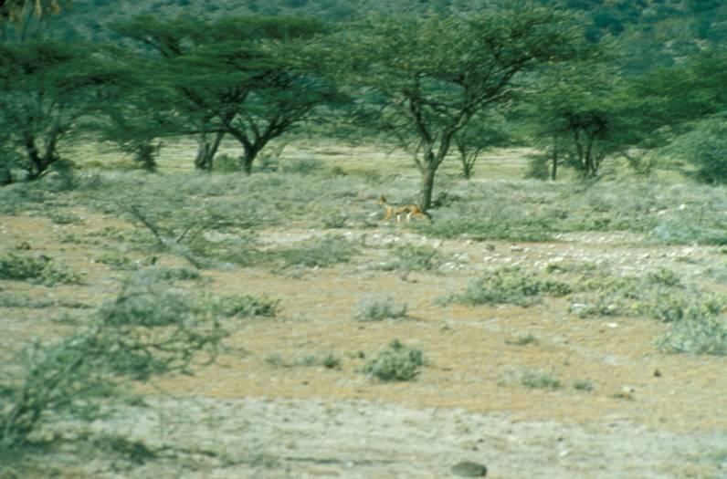
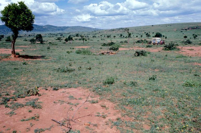
10 Sparsely vegetated, low-infiltration landscapes
11 Land use, hydrologic conditions and stream response
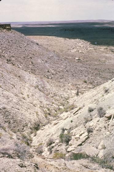
12 Runoff generation Dunnian mechanism (1) Saturation overland flow (Dunnian mechanism) Saturation overland flow is overland flow that occurs due to saturation from below. It consists of direct water input to the saturated area plus the return flow contributed by the breakout of ground water from upslope. The extension of the saturated area varies with time according with the rate of the subsurface flow.

13 Runoff generation Dunnian mechanism (2) Seasonal variation of saturation overland flow on low-permeability glacial till, Vermont
14 Runoff generation Dunnian mechanism (3) Saturation overland flow from spring snowmelt, near Wenatchee, E. Washington

15 Runoff generation Dunnian mechanism (4) Interflow, exfiltration and direct precipitation generate saturation overland flow on parts of landscapes Saturation overland flow from spring snowmelt, near Wenatchee, E. Washington
16 Runoff generation Subsurface flow dominated landscapes Steep, shallow, forested soil over volcanic rocks, Japanese Alps generates shallow subsurface flow (throughflow/interflow)


17 Runoff generation Subsurface flow dominated landscapes Steep, shallow, forested soil over volcanic rocks, Japanese Alps generates shallow subsurface flow (throughflow/interflow) Interflow
18 Schematic summary of controls on runoff pathways Saturation Overland Flow Storm Precipitation Hortonian Overland Flow Channel Precip. + Overland Flow Soil Mantle Storage Overland Flow Subsurface Stormflow Baseflow Interflow Basin Hydrograph Re-drawn from Hewlett and Troendle, 1975


19 Dominant processes of hillslope response to rainfall
20 Runoff generation and impact on lag time and flood peak
Each basin is surrounded & defined by a drainage divide (high point from which water flows away) Channel initiation
 Channel initiation") DRAINAGE BASINS A drainage basin or watershed is defined from a downstream point, working upstream, to include all of the hillslope & channel areas which drain to that point Each basin is surrounded &
DRAINAGE BASINS A drainage basin or watershed is defined from a downstream point, working upstream, to include all of the hillslope & channel areas which drain to that point Each basin is surrounded &
2 Development of a Physically Based Hydrologic Model of the Upper Cosumnes Basin
 2 Development of a Physically Based Hydrologic Model of the Upper Cosumnes Basin 2.1 Introduction The physically based watershed hydrologic model, WEHY (watershed environmental hydrology) model (Kavvas
12 SWAT USER S MANUAL, VERSION 98.1
 12 SWAT USER S MANUAL, VERSION 98.1 CANOPY STORAGE. Canopy storage is the water intercepted by vegetative surfaces (the canopy) where it is held and made available for evaporation. When using the curve
Hillslope Hydrology Q 1 Q Understand hillslope runoff processes. 2. Understand the contribution of groundwater to storm runoff.
 Objectives Hillslope Hydrology Streams are the conduits of the surface and subsurface runoff generated in watersheds. SW-GW interaction needs to be understood from the watershed perspective. During a storm
Which map shows the stream drainage pattern that most likely formed on the surface of this volcano? A) B)
 B)") 1. When snow cover on the land melts, the water will most likely become surface runoff if the land surface is A) frozen B) porous C) grass covered D) unconsolidated gravel Base your answers to questions
1. When snow cover on the land melts, the water will most likely become surface runoff if the land surface is A) frozen B) porous C) grass covered D) unconsolidated gravel Base your answers to questions
INTRODUCTION TO HEC-HMS
 INTRODUCTION TO HEC-HMS Hydrologic Engineering Center- Hydrologic Modeling System US Army Corps of Engineers Hydrologic Engineering Center HEC-HMS Uses Schematics Enter properties: watershed, rivers (reaches),
UGRC 144 Science and Technology in Our Lives/Geohazards
 UGRC 144 Science and Technology in Our Lives/Geohazards Flood and Flood Hazards Dr. Patrick Asamoah Sakyi Department of Earth Science, UG, Legon College of Education School of Continuing and Distance Education
WATER ON AND UNDER GROUND. Objectives. The Hydrologic Cycle
 WATER ON AND UNDER GROUND Objectives Define and describe the hydrologic cycle. Identify the basic characteristics of streams. Define drainage basin. Describe how floods occur and what factors may make
Objectives: After completing this assignment, you should be able to:
 Data Analysis Assignment #1 Evaluating the effects of watershed land use on storm runoff Assignment due: 21 February 2013, 5 pm Objectives: After completing this assignment, you should be able to: 1) Calculate
2008 JC2 H2 GEOGRAPHY: PIONEER JUNIOR COLLEGE PRELIMINARY EXAMS. Figure 1 for Question 1
 PHYSICAL GEOGRAPHY Figure 1 for Question 1 Figure 2 for Question 2 Tropical air mass source regions Figure 3 for Question 3 Figure 4 for Question 4 Volcanic gases Figure 5 for Question 5 EITHER Photograph
GEOL 1121 Earth Processes and Environments
 GEOL 1121 Earth Processes and Environments Wondwosen Seyoum Department of Geology University of Georgia e-mail: seyoum@uga.edu G/G Bldg., Rm. No. 122 Seyoum, 2015 Chapter 6 Streams and Flooding Seyoum,
KINEROS2/AGWA. Fig. 1. Schematic view (Woolhiser et al., 1990).
.") KINEROS2/AGWA Introduction Kineros2 (KINematic runoff and EROSion) (K2) model was originated at the USDA-ARS in late 1960s and released until 1990 (Smith et al., 1995; Woolhiser et al., 1990). The spatial
KINEROS2/AGWA Introduction Kineros2 (KINematic runoff and EROSion) (K2) model was originated at the USDA-ARS in late 1960s and released until 1990 (Smith et al., 1995; Woolhiser et al., 1990). The spatial
Non-linearity effects in the process of floods generation
 Non-linearity effects in the process of floods generation M. FIORENTINO a & V. IACOBELLIS b a Dipartimento di Ingegneria e Fisica dell Ambiente, Università della Basilicata, Contrada Macchia Romana, I-851,
Flood Forecasting Tools for Ungauged Streams in Alberta: Status and Lessons from the Flood of 2013
 Flood Forecasting Tools for Ungauged Streams in Alberta: Status and Lessons from the Flood of 2013 John Pomeroy, Xing Fang, Kevin Shook, Tom Brown Centre for Hydrology, University of Saskatchewan, Saskatoon
Fresh Water: Streams, Lakes Groundwater & Wetlands
 Fresh Water:, Lakes Groundwater & Wetlands Oct 27 Glaciers and Ice Ages Chp 13 Nov 3 Deserts and Wind and EXAM #3 Slope hydrologic cycle P = precip I = precip intercepted by veg ET = evapotranspiration
+ ( f o. (t) = f c. f c. )e kt (1)
 = f c. f c. )e kt (1)") CIVE Basic Hydrology Jorge A. Ramírez Computations Example Assume that the time evolution of the infiltration capacity for a given soil is governed by Horton's equation (Note that this equation assumes
CIVE Basic Hydrology Jorge A. Ramírez Computations Example Assume that the time evolution of the infiltration capacity for a given soil is governed by Horton's equation (Note that this equation assumes
CARFFG System Development and Theoretical Background
 CARFFG Steering Committee Meeting 15 SEPTEMBER 2015 Astana, KAZAKHSTAN CARFFG System Development and Theoretical Background Theresa M. Modrick, PhD Hydrologic Research Center Key Technical Components -
Governing Rules of Water Movement
 Governing Rules of Water Movement Like all physical processes, the flow of water always occurs across some form of energy gradient from high to low e.g., a topographic (slope) gradient from high to low
RIVERS, GROUNDWATER, AND GLACIERS
 RIVERS, GROUNDWATER, AND GLACIERS Delta A fan-shaped deposit that forms when a river flows into a quiet or large body of water, such as a lake, an ocean, or an inland sea. Alluvial Fan A sloping triangle
Quantifying shallow subsurface flow and salt transport in the Canadian Prairies
 Quantifying shallow subsurface flow and salt transport in the Canadian Prairies Andrew Ireson GIWS, University of Saskatchewan www.usask.ca/water Uri Nachshon Garth van der Kamp GIWS, University of Saskatchewan
Hydrologic Forecast Centre Manitoba Infrastructure, Winnipeg, Manitoba. FEBRUARY OUTLOOK REPORT FOR MANITOBA February 23, 2018
 Page 1 of 17 Hydrologic Forecast Centre Manitoba Infrastructure, Winnipeg, Manitoba FEBRUARY OUTLOOK REPORT FOR MANITOBA February 23, 2018 Overview The February Outlook Report prepared by the Hydrologic
INTRODUCTION Water resources are vitally important for the future of humankind. Groundwater from karst aquifers is among the most important drinking w
 Vulnerability Mapping for the Protection of Carbonate (Karst) Aquifers (Ramallah-Al Bireh District) Eng. Amjad da Assi House of fw Water and de Environment May, 2007 INTRODUCTION Water resources are vitally
2016 Fall Conditions Report
 2016 Fall Conditions Report Prepared by: Hydrologic Forecast Centre Date: December 13, 2016 Table of Contents TABLE OF FIGURES... ii EXECUTIVE SUMMARY... 1 BACKGROUND... 5 SUMMER AND FALL PRECIPITATION...
Hydrogeomorphological characteristics of a zero-order basin
 Erosion and Sedimentation m the Pacific Rim (Proceedings of the Corvallis Symposium, August, 1987). IAHS Pubi. no. 165. Hydrogeomorphological characteristics of a zero-order basin INTRODUCTION YOSHINORI
Hydrologic Overview & Quantities
 Hydrologic Overview & Quantities It is important to understand the big picture when attempting to forecast. This includes the interactive components and hydrologic quantities. Hydrologic Cycle The complexity
MET 3102-U01 PHYSICAL CLIMATOLOGY (ID 17901) Lecture 14
 Lecture 14") MET 3102-U01 PHYSICAL CLIMATOLOGY (ID 17901) Lecture 14 The hydrologic cycle evaporation vapor transport precipitation precipitation evaporation runoff Evaporation, precipitation, etc. in cm Vapor transported
MET 3102-U01 PHYSICAL CLIMATOLOGY (ID 17901) Lecture 14 The hydrologic cycle evaporation vapor transport precipitation precipitation evaporation runoff Evaporation, precipitation, etc. in cm Vapor transported
SNOW AND GLACIER HYDROLOGY
 SNOW AND GLACIER HYDROLOGY by PRATAP SINGH National Institute of Hydrology, Roorkee, India and VIJAY P. SINGH Department of Civil and Environmental Engineering, Louisiana State University, Baton Rouge,
Floodplain modeling. Ovidius University of Constanta (P4) Romania & Technological Educational Institute of Serres, Greece
 Romania & Technological Educational Institute of Serres, Greece") Floodplain modeling Ovidius University of Constanta (P4) Romania & Technological Educational Institute of Serres, Greece Scientific Staff: Dr Carmen Maftei, Professor, Civil Engineering Dept. Dr Konstantinos
Floodplain modeling Ovidius University of Constanta (P4) Romania & Technological Educational Institute of Serres, Greece Scientific Staff: Dr Carmen Maftei, Professor, Civil Engineering Dept. Dr Konstantinos
A PARAMETER ESTIMATE FOR THE LAND SURFACE MODEL VIC WITH HORTON AND DUNNE RUNOFF MECHANISM FOR RIVER BASINS IN CHINA
 A PARAMETER ESTIMATE FOR THE LAND SURFACE MODEL VIC WITH HORTON AND DUNNE RUNOFF MECHANISM FOR RIVER BASINS IN CHINA ZHENGHUI XIE Institute of Atmospheric Physics, Chinese Academy of Sciences Beijing,
3/3/2013. The hydro cycle water returns from the sea. All "toilet to tap." Introduction to Environmental Geology, 5e
 Introduction to Environmental Geology, 5e Running Water: summary in haiku form Edward A. Keller Chapter 9 Rivers and Flooding Lecture Presentation prepared by X. Mara Chen, Salisbury University The hydro
Conservation Planning evaluate land management alternatives to reduce soil erosion to acceptable levels. Resource Inventories estimate current and
 Conservation Planning evaluate land management alternatives to reduce soil erosion to acceptable levels. Resource Inventories estimate current and projected erosion levels and their impact on natural resource
Appendix 2: Hydrometeorology and Hydroclimatology of Baseflow. Page 1 of 19
 Appendix 2: Hydrometeorology and Hydroclimatology of Baseflow Page 1 of 19 A time series of end of month soil moisture data was developed for each climate division in the United States from 1931 to present
ENGINEERING HYDROLOGY
 ENGINEERING HYDROLOGY Prof. Rajesh Bhagat Asst. Professor Civil Engineering Department Yeshwantrao Chavan College Of Engineering Nagpur B. E. (Civil Engg.) M. Tech. (Enviro. Engg.) GCOE, Amravati VNIT,
Hydrologic Forecast Centre Manitoba Infrastructure, Winnipeg, Manitoba. MARCH OUTLOOK REPORT FOR MANITOBA March 23, 2018
 Page 1 of 21 Hydrologic Forecast Centre Manitoba Infrastructure, Winnipeg, Manitoba MARCH OUTLOOK REPORT FOR MANITOBA March 23, 2018 Overview The March Outlook Report prepared by the Hydrologic Forecast
Effect of spatial heterogeneity of runoff generation mechanisms on the scaling behavior of event runoff responses in a natural river basin
 WATER RESOURCES RESEARCH, VOL. 47, W00H08, doi:10.1029/2010wr009712, 2011 Effect of spatial heterogeneity of runoff generation mechanisms on the scaling behavior of event runoff responses in a natural
Continuing Education Associated with Maintaining CPESC and CESSWI Certification
 Continuing Education Associated with Maintaining CPESC and CESSWI Certification Module 2: Stormwater Management Principles for Earth Disturbing Activities Sponsors: ODOTs Local Technical Assistance Program
Texas Alliance of Groundwater Districts Annual Summit
 Texas Alliance of Groundwater Districts Annual Summit Using Remote-Sensed Data to Improve Recharge Estimates August 28, 2018 by Ronald T. Green1, Ph.D., P.G. and Stu Stothoff2, Ph.D., P.G. Earth Science
CIVE322 BASIC HYDROLOGY
 CIVE322 BASIC HYDROLOGY Homework No.3 Solution 1. The coordinates of four precipitation gauging stations are A = (3,4), B = (9,4), C = (3,12), and D = (9,12). The observed precipitation amounts at these
Advanced Hydrology Prof. Dr. Ashu Jain Department of Civil Engineering Indian Institute of Technology, Kanpur. Lecture 6
 Advanced Hydrology Prof. Dr. Ashu Jain Department of Civil Engineering Indian Institute of Technology, Kanpur Lecture 6 Good morning and welcome to the next lecture of this video course on Advanced Hydrology.
APPLICATIONS OF DOWNSCALING: HYDROLOGY AND WATER RESOURCES EXAMPLES
 APPLICATIONS OF DOWNSCALING: HYDROLOGY AND WATER RESOURCES EXAMPLES Dennis P. Lettenmaier Department of Civil and Environmental Engineering For presentation at Workshop on Regional Climate Research NCAR
Surface Processes Focus on Mass Wasting (Chapter 10)
") Surface Processes Focus on Mass Wasting (Chapter 10) 1. What is the distinction between weathering, mass wasting, and erosion? 2. What is the controlling force in mass wasting? What force provides resistance?
Surface Processes Focus on Mass Wasting (Chapter 10) 1. What is the distinction between weathering, mass wasting, and erosion? 2. What is the controlling force in mass wasting? What force provides resistance?
ONE DIMENSIONAL CLIMATE MODEL
 JORGE A. RAMÍREZ Associate Professor Water Resources, Hydrologic and Environmental Sciences Civil Wngineering Department Fort Collins, CO 80523-1372 Phone: (970 491-7621 FAX: (970 491-7727 e-mail: Jorge.Ramirez@ColoState.edu
Forest Hydrology: The Japanese Experience
 Forest Hydrology: The Japanese Experience Roy C. Sidle Professor of Geography Sustainability Research Centre University of the Sunshine Coast Queensland, Australia FFPRI, Tsukuba, Hokkaido PWRI, Tsukuba
GEOLOGY CURRICULUM. Unit 1: Introduction to Geology
 Chariho Regional School District - Science Curriculum September, 2016 GEOLOGY CURRICULUM Unit 1: Introduction to Geology OVERVIEW Summary In this unit students will be introduced to the field of geology.
Sustainable Forest Management in Watersheds
 Sustainable Forest Management in Watersheds UBC FRST 555 August 27, 2015 Kim Green, P.Geo., PhD Apex Geoscience Consultants Ltd Outline - Forests and Watersheds Scaling up from stand to watershed-level
CHAPTER-11 CLIMATE AND RAINFALL
 CHAPTER-11 CLIMATE AND RAINFALL 2.1 Climate Climate in a narrow sense is usually defined as the "average weather", or more rigorously, as the statistical description in terms of the mean and variability
Functional intercomparison of hillslopes and small catchments by examining water source, flowpath and mean residence time
 Journal of Hydrology (26) 327, 627 642 available at www.sciencedirect.com journal homepage: www.elsevier.com/locate/jhydrol Functional intercomparison of hillslopes and small catchments by examining water
Appendix D. Model Setup, Calibration, and Validation
 . Model Setup, Calibration, and Validation Lower Grand River Watershed TMDL January 1 1. Model Selection and Setup The Loading Simulation Program in C++ (LSPC) was selected to address the modeling needs
 12 10 8 6 4 2 0 40-50 50-60 60-70 70-80 80-90 90-100 Fresh Water What we will cover The Hydrologic Cycle River systems Floods Groundwater Caves and Karst Topography Hot springs Distribution of water in
Assessment of extreme flood characteristics based on a dynamic-stochastic model of runoff generation and the probable maximum discharge
 Risk in Water Resources Management (Proceedings of Symposium H3 held during IUGG211 in Melbourne, Australia, July 211) (IAHS Publ. 347, 211). 29 Assessment of extreme flood characteristics based on a dynamic-stochastic
The Search for Catchment-Scale Physics: Spatial Scaling & Similarity with Hydrological Heterogeneity
 The Search for Catchment-Scale Physics: Spatial Scaling & Similarity with Hydrological Heterogeneity Ross Woods University of Bristol Symposium in Honor of Eric Wood: Observations and Modeling across Scales,
The role of near-stream riparian zones in the hydrology of steep upland catchments
 Hydrology, Water Resources and Ecology in Headwaters (Proceedings of the HeadWater'98 Conference held at Meran/Merano, Italy, April 1998). IAHS Publ. no. 248, 1998. 17^ The role of near-stream riparian
Lake Tahoe Watershed Model. Lessons Learned through the Model Development Process
 Lake Tahoe Watershed Model Lessons Learned through the Model Development Process Presentation Outline Discussion of Project Objectives Model Configuration/Special Considerations Data and Research Integration
1. Water in Soils: Infiltration and Redistribution
 Contents 1 Water in Soils: Infiltration and Redistribution 1 1a Material Properties of Soil..................... 2 1b Soil Water Flow........................... 4 i Incorporating K - θ and ψ - θ Relations
Water Quality and Water Quantity: Two sides of the Same Coin. Chris Jones
 Water Quality and Water Quantity: Two sides of the Same Coin Chris Jones Unit of the College of Engineering Director: Larry Weber 90 Graduate Students from 16 countries 61 Research Engineers and Scientists
Aquifer an underground zone or layer of sand, gravel, or porous rock that is saturated with water.
 Aggradation raising of the streambed by deposition that occurs when the energy of the water flowing through a stream reach is insufficient to transport sediment conveyed from upstream. Alluvium a general
Soil Formation. Lesson Plan: NRES B2-4
 Soil Formation Lesson Plan: NRES B2-4 1 Anticipated Problems 1. What are five different factors that affect soil formation? 2. What are some different types of parent material that affect soils? 3. What
Workshop: Build a Basic HEC-HMS Model from Scratch
 Workshop: Build a Basic HEC-HMS Model from Scratch This workshop is designed to help new users of HEC-HMS learn how to apply the software. Not all the capabilities in HEC-HMS are demonstrated in the workshop
Physically-based hydrological modelling on the hillslope and micro-catchment scale: examples of capabilities and limitations
 Hydrology, Water Resources and Ecology in Headwaters (Proceedings of the HeadWater'98 Conference ~~~ held at Meran/Merano, Italy, April 1998). IAHS Publ. no. 248, 1998. 207 Physically-based hydrological
Drought Monitoring with Hydrological Modelling
 st Joint EARS/JRC International Drought Workshop, Ljubljana,.-5. September 009 Drought Monitoring with Hydrological Modelling Stefan Niemeyer IES - Institute for Environment and Sustainability Ispra -
CHAPTER VII FULLY DISTRIBUTED RAINFALL-RUNOFF MODEL USING GIS
 80 CHAPTER VII FULLY DISTRIBUTED RAINFALL-RUNOFF MODEL USING GIS 7.1GENERAL This chapter is discussed in six parts. Introduction to Runoff estimation using fully Distributed model is discussed in first
Haiti-Dominican Republic Flash Flood Guidance (HDRFFG) System: Development of System Products
 System: Development of System Products") Haiti-Dominican Republic Flash Flood Guidance (HDRFFG) System: Development of System Products Theresa M. Modrick, PhD Hydrologic Research Center HDRFFG Initial Planning Meeting 07-09 Sep 2015 Santo Domingo,
Haiti-Dominican Republic Flash Flood Guidance (HDRFFG) System: Development of System Products Theresa M. Modrick, PhD Hydrologic Research Center HDRFFG Initial Planning Meeting 07-09 Sep 2015 Santo Domingo,
Physical Geography. Physical Geography IV of the United States and Canada. Frozen Niagara Falls Definitions. Frozen Great Lakes
 Physical Geography IV of the United States and Canada Prof. Anthony Grande AFG 0 Physical Geography The physical landscape (natural environment) sets the stage for human use (cultural landscape). We need
Rainfall Analysis. Prof. M.M.M. Najim
 Rainfall Analysis Prof. M.M.M. Najim Learning Outcome At the end of this section students will be able to Estimate long term mean rainfall for a new station Describe the usage of a hyetograph Define recurrence
Chapter 2. Regional Landscapes and the Hydrologic Cycle
 Chapter 2. Regional Landscapes and the Hydrologic Cycle W. Lee Daniels Department of Crop and Soil Environmental Sciences, Virginia Tech Table of Contents Introduction... 23 Soils and landscapes of the
ψ ae is equal to the height of the capillary rise in the soil. Ranges from about 10mm for gravel to 1.5m for silt to several meters for clay.
 Contents 1 Infiltration 1 1a Hydrologic soil horizons...................... 1 1b Infiltration Process......................... 2 1c Measurement............................ 2 1d Richard s Equation.........................
' International Institute for Land Reclamation and Improvement. 2 Groundwater Investigations. N.A. de Ridder'? 2.1 Introduction. 2.
 2 Groundwater Investigations N.A. de Ridder'? 2.1 Introduction Successful drainage depends largely on a proper diagnosis of the causes of the excess water. For this diagnosis, one must consider: climate,
A Near Real-time Flood Prediction using Hourly NEXRAD Rainfall for the State of Texas Bakkiyalakshmi Palanisamy
 A Near Real-time Flood Prediction using Hourly NEXRAD for the State of Texas Bakkiyalakshmi Palanisamy Introduction Radar derived precipitation data is becoming the driving force for hydrological modeling.
The elevations on the interior plateau generally vary between 300 and 650 meters with
 11 2. HYDROLOGICAL SETTING 2.1 Physical Features and Relief Labrador is bounded in the east by the Labrador Sea (Atlantic Ocean), in the west by the watershed divide, and in the south, for the most part,
Hydrologic Modelling of the Upper Malaprabha Catchment using ArcView SWAT
 Hydrologic Modelling of the Upper Malaprabha Catchment using ArcView SWAT Technical briefs are short summaries of the models used in the project aimed at nontechnical readers. The aim of the PES India
POTENTIAL WATER STORAGE CAPACITY OF MOUNTAINOUS CATCHMENTS BASED ON CATCHMENT CHARACTERISTICS
 Annual Journal of Hydraulic Engineering, JSCE, Vol.59, 215, February POTENTIAL WATER STORAGE CAPACITY OF MOUNTAINOUS CATCHMENTS BASED ON CATCHMENT CHARACTERISTICS Intan SUPRABA 1, Tomohito J. YAMADA 2
6.1 Water. The Water Cycle
 6.1 Water The Water Cycle Water constantly moves among the oceans, the atmosphere, the solid Earth, and the biosphere. This unending circulation of Earth s water supply is the water cycle. The Water Cycle
Prentice Hall EARTH SCIENCE
 Prentice Hall EARTH SCIENCE Tarbuck Lutgens Running Water and Groundwater Running Water The Water Cycle Water constantly moves among the oceans, the atmosphere, the solid Earth, and the biosphere. This
A new probability density function for spatial distribution of soil water storage capacity. leads to SCS curve number method
 1 2 3 4 5 6 7 8 9 10 11 12 13 14 15 16 A new probability density function for spatial distribution of soil water storage capacity leads to SCS curve number method Dingbao ang Department of Civil, Environmental,
STUDY GUIDE FOR CONTENT MASTERY. Surface Water Movement
 Surface Water SECTION 9.1 Surface Water Movement In your textbook, read about surface water and the way in which it moves sediment. Complete each statement. 1. An excessive amount of water flowing downslope
Geog Lecture 19
 Geog 1000 - Lecture 19 Fluvial Geomorphology and River Systems http://scholar.ulethbridge.ca/chasmer/classes/ Today s Lecture (Pgs 346 355) 1. What is Fluvial Geomorphology? 2. Hydrology and the Water
Application of SWAT for the modelling of sediment yield at Pong reservoir, India
 Application of SWAT for the modelling of sediment yield at Pong reservoir, India A. R. Senthil kumar Tanmoyee Bhattacharya Suhas D Khobragade Manohar Arora National Institute of Hydrology Roorkee-247667,
Surface & subsurface processes in mountain environments
 Surface & subsurface processes in mountain environments evapotranspiration snowmelt precipitation infiltration Roger Bales Martha Conklin Robert Rice Fengjing Liu Peter Kirchner runoff sublimation ground
Unit E: Basic Principles of Soil Science. Lesson 2: Understanding Soil Formation
 Unit E: Basic Principles of Soil Science Lesson 2: Understanding Soil Formation Important Terms Alluvium Bedrock Chemical weathering Climate Glacial till Loess Native vegetation Organic matter Outwash
1 BASIC CONCEPTS AND MODELS
 1 BASIC CONCEPTS AND ODELS 1.1 INTRODUCTION This Volume III in the series of textbooks is focused on applications of environmental isotopes in surface water hydrology. The term environmental means that
Monitoring Headwater Streams for Landscape Response to
 Monitoring Headwater Streams for Landscape Response to Climate Change Matthew Connor, PhD Connor nvironmental, nc. www.oe-i.com icom Healdsburg, California verview Headwater stream geomorphology Response
Napa Valley Groundwater Sustainability: A Basin Analysis Report for the Napa Valley Subbasin
 Napa Valley Groundwater Sustainability: A Basin Analysis Report for the Napa Valley Subbasin December 13, 2016 Napa County Board of Supervisors By Vicki Kretsinger Grabert and Reid Bryson Basin Analysis
Modelling changes in the runoff regime in Slovakia using high resolution climate scenarios
 Modelling changes in the runoff regime in Slovakia using high resolution climate scenarios K. HLAVČOVÁ, R. VÝLETA, J. SZOLGAY, S. KOHNOVÁ, Z. MACUROVÁ & P. ŠÚREK Department of Land and Water Resources
Drought Criteria. Richard J. Heggen Department of Civil Engineering University of New Mexico, USA Abstract
 Drought Criteria Richard J. Heggen Department of Civil Engineering University of New Mexico, USA rheggen@unm.edu Abstract Rainwater catchment is an anticipatory response to drought. Catchment design requires
The impact of hill land clearance and urbanization on runoff and sediment yield of small catchments in Pulau Pinang, Malaysia
 Human Impact on Erosion and Sedimentation (Proceedings of Rabat Symposium S6, April 1997). IAHS Publ. no. 245, 1997 91 The impact of hill land clearance and urbanization on runoff and sediment yield of
Remote Sensing and GIS Applications for Hilly Watersheds SUBASHISA DUTTA DEPARTMENT OF CIVIL ENGINEERING IIT GUWAHATI
 Remote Sensing and GIS Applications for Hilly Watersheds SUBASHISA DUTTA DEPARTMENT OF CIVIL ENGINEERING IIT GUWAHATI Deciding Alternative Land Use Options in a Watershed Using GIS Source: Anita Prakash
Environment Canada Modelling Systems and the 2013 Alberta Floods
 Environment Canada Modelling Systems and the 2013 Alberta Floods Calgary, Alberta February 19, 2014 Bruce Davison (EC) Al Pietroniro (EC) Nick Kouwen (UW) Anthony Liu (EC) Muluneh Mekonnen (AB) Ron Goodison
UK Flooding Feb 2003
 UK Flooding 2000 06 Feb 2003 Britain has taken a battering from floods in the last 5 years, with major events in 1998 and 2000, significant floods in 2001 and minor events in each of the other years. So
UNIT 12: THE HYDROLOGIC CYCLE
 UNIT 12: THE HYDROLOGIC CYCLE After Unit 12 you should be able to: o Effectively use the charts Average Chemical Composition of Earth s Crust, Hydrosphere and Troposphere, Selected Properties of Earth
Introduction to Soil Science and Wetlands Kids at Wilderness Camp
 Introduction to Soil Science and Wetlands Kids at Wilderness Camp Presented by: Mr. Brian Oram, PG, PASEO B.F. Environmental Consultants http://www.bfenvironmental.com and Keystone Clean Water Team http://www.pacleanwater.org
P. Marsh and J. Pomeroy National Hydrology Research Institute 11 Innovation Blvd., Saskatoon, Sask. S7N 3H5
 WATER AND ENERGY FLUXES DURING THE SNOWMELT PERIOD AT AN ARCTIC TREELINE SITE P. Marsh and J. Pomeroy National Hydrology Research Institute 11 Innovation Blvd., Saskatoon, Sask. S7N 3H5 marshp@nhrisv.nhrc.skdoe.ca
Rainfall-runoff modeling in humid shallow water table environments
 University of South Florida Scholar Commons Graduate Theses and Dissertations Graduate School 2001 Rainfall-runoff modeling in humid shallow water table environments Tatiana X. Hernandez University of
Discussion of Response of a residual soil slope to rainfall 1
 979 DISCUSSION / DISCUSSION Discussion of Response of a residual soil slope to rainfall 1 Ana C. Londono Received 22 January 2006. Accepted 15 June 2006. Published on the NRC Research Press Web site at
This graph best represents the elements of the Earth's A) lithosphere B) hydrosphere C) troposphere D) stratosphere
 lithosphere B) hydrosphere C) troposphere D) stratosphere") 1. Surface ocean currents resulting from the prevailing winds over the oceans illustrate a transfer of energy from A) lithosphere to atmosphere B) hydrosphere to lithosphere C) atmosphere to hydrosphere
1. Surface ocean currents resulting from the prevailing winds over the oceans illustrate a transfer of energy from A) lithosphere to atmosphere B) hydrosphere to lithosphere C) atmosphere to hydrosphere
HYDROGRAPH SEPARATION: GRAPHICAL AND TRACER METHODS (AND WHAT THEY REVEAL ABOUT URBAN WATERSHEDS) 19 February 2013 Urban Hydrology
 19 February 2013 Urban Hydrology") HYDROGRAPH SEPARATION: GRAPHICAL AND TRACER METHODS (AND WHAT THEY REVEAL ABOUT URBAN WATERSHEDS) 19 February 2013 Urban Hydrology Why do hydrologists want to separate hydrographs? Where does surface runoff
HYDROGRAPH SEPARATION: GRAPHICAL AND TRACER METHODS (AND WHAT THEY REVEAL ABOUT URBAN WATERSHEDS) 19 February 2013 Urban Hydrology Why do hydrologists want to separate hydrographs? Where does surface runoff
Haiti and Dominican Republic Flash Flood Initial Planning Meeting
 Dr Rochelle Graham Climate Scientist Haiti and Dominican Republic Flash Flood Initial Planning Meeting September 7 th to 9 th, 2016 Hydrologic Research Center http://www.hrcwater.org Haiti and Dominican
DEVELOPMENT OF A LARGE-SCALE HYDROLOGIC PREDICTION SYSTEM
 JP3.18 DEVELOPMENT OF A LARGE-SCALE HYDROLOGIC PREDICTION SYSTEM Ji Chen and John Roads University of California, San Diego, California ABSTRACT The Scripps ECPC (Experimental Climate Prediction Center)
Adapting WEPP (Water Erosion Prediction Project) for Forest Watershed Erosion Modeling
 for Forest Watershed Erosion Modeling") Adapting WEPP (Water Erosion Prediction Project) for Forest Watershed Erosion Modeling Joan Q. Wu Arthur C. Xu William J. Elliot Department of Biological Systems Engineering Rocky Mountain Research Station
Adapting WEPP (Water Erosion Prediction Project) for Forest Watershed Erosion Modeling Joan Q. Wu Arthur C. Xu William J. Elliot Department of Biological Systems Engineering Rocky Mountain Research Station
EROSION AND SEDIMENT TRANSPORT IN A PROPOSED REGIONAL SANITARY LANDFILL. Jorge Rivera Santos 1 * Godofredo Canino 2
 EROSION AND SEDIMENT TRANSPORT IN A PROPOSED REGIONAL SANITARY LANDFILL Jorge Rivera Santos 1 * Godofredo Canino 2 1 Puerto Rico Water Resources Research Institute School of Engineering P.O.Box 5000 Mayagüez,
Determination of the geomorphological instantaneous unit hydrograph using tracer experiments in a headwater basin
 Hydrology, Water Resources and Ecology in Headwaters (Proceedings of the HeadWater'98 Conference held at Meran/Merano, Italy, April 1998). 1AHS Publ. no. 248, 1998. 327 Determination of the geomorphological