GENT FAIRHEAD & CO. LTD. Submitted to: Mr. Tom Fairhead, Gent Fairhead & Co. Ltd, 9 Royal Crescent, London, W11 4SL /B.
|
|
|
- Felix Morris
- 5 years ago
- Views:
Transcription

1 February 21 GENT FAIRHEAD & CO. LTD 29 Ground Investigation at Rivenhall Airfield, Essex Submitted to: Mr. Tom Fairhead, Gent Fairhead & Co. Ltd, 9 Royal Crescent, London, W11 4SL REPORT Report Number: Distribution: /B. Gent Fairhead & Co Ltd - 2 copies (1 pdf) Blackwater Aggregates - 2 copies (1 pdf) Golder Associates (UK) Ltd - 1 copy
2 29 RIVENHALL GROUND INVESTIGATION Record of Issue Company Client Contact Version Date Issued Method of Delivery Gent Fairhead & Co Ltd Tom Fairhead /B. 8 February 21 Post and Blackwater Aggregates Patrick Wigg /B. 8 February 21 Post and February 21 Report No /B.
3 29 RIVENHALL GROUND INVESTIGATION Executive Summary Golder Associates (UK) Ltd carried out a ground investigation at Rivenhall Airfield in June 29 on behalf of Gent Fairhead & Co Ltd (GFC). GFC commissioned Golder to develop an evolution of the planned Recycling and Composting Facility (the ercf) at Rivenhall Airfield (the Site). The ercf is a development of the original Recycling and Composting Facility (RCF) design, for which Essex County Council resolved to grant planning permission on 3 March 27 for the Site at Rivenhall Airfield. Golder commissioned Boart Longyear Environmental & Infrastructure Drilling Service (Boart Longyear) to undertake rota-sonic drilling of four drill holes. Locations were selected by Golder to provide an initial characterisation of the geotechnical and geological ground conditions for the initial design of foundations and retaining walls. Golder supervised drilling works and logged the cores. Borehole logs (provided as Appendix A to this report) indicate that clay is present below an initial Made Ground layer. A band of sand and/or gravel intersperses the clay for a few metres, with further clay present below this. Standard Penetration Tests (SPTs) were carried out during drilling, the results of which are detailed within the borehole logs. Sub samples of the cores were taken and subsequently dispatched to the GEOLABS Ltd laboratory for geotechnical analysis. Analysis results are provided as Appendix D to this report. Three standpipe piezometers and two vibrating wire piezometers were installed in the boreholes detailed in the borehole logs contained in Appendix A. February 21 Report No /B.
4 29 RIVENHALL GROUND INVESTIGATION Table of Contents 1. INTRODUCTION Purpose DESK STUDY Site Description Site Geology Site Hydrogeology Previous Ground Investigation FIELDWORK Drilling Works Drilling Supervision Works In Situ Testing Installations Standpipe Piezometers Vibrating Wire Piezometer LABORATORY TESTING RESULTS Geotechnical Test Results Chemical Test Results REFERENCES TABLES Table 1: Borehole Installation Details... 5 Table 2: Standpipe Piezometer Readings... 5 Table 3: Boulder Clay Geotechnical Test Results Summary... 7 Table 4: Sand & Gravel Geotechnical Test Results Summary... 7 Table 5: London Clay Geotechnical Test Results Summary... 8 Table 6: Boulder Clay Chemical Testing Summary... 9 Table 7: Sand & Gravel Chemical Testing Summary... 9 Table 8: London Clay Chemical Testing Summary... 9 February 21 Report No /B. i
5 29 RIVENHALL GROUND INVESTIGATION APPENDICES APPENDIX A Golder Borehole Logs APPENDIX B Historic Borehole Logs APPENDIX C Vibrating Wire Installation Information APPENDIX D GEOLABS Analysis Results APPENDIX E Drawing February 21 Report No /B. ii
6 29 RIVENHALL GROUND INVESTIGATION 1. INTRODUCTION Golder Associates (UK) Ltd (Golder) was commissioned by Gent Fairhead & Co Limited (GFC) in June 29 to undertake a site investigation at Rivenhall Airfield, Essex (the Site). GFC propose to develop an evolution to a planned Recycling and Composting Facility (the ercf) at the Site. The ercf is a development of the original Recycling and Composting Facility (RCF) design, for which Essex County Council resolved to grant planning permission on 3 March 27 for the Site at Rivenhall Airfield. Ground investigation works took place between the 8 and 16 June 29 with Boart Longyear Environmental & Infrastructure Drilling Service (Boart Longyear) commissioned by Golder to undertake drilling works. Boart Longyear mobilised two Rota-Sonic drilling rigs to develop four boreholes in locations specified by Golder. This factual report represents the results of site investigation and associated laboratory analysis, with borehole logs provided in Appendix A. 1.1 Purpose The programme of work was undertaken to investigate in further detail the ground conditions at Rivenhall Airfield. The infrastructure required to develop the Site for the construction and operation of the ercf will include foundations, retaining walls, roads and services. The ground investigation work was undertaken to enable an initial characterisation of the ground conditions to inform preliminary design. Rota-Sonic drill holes were to be undertaken to depths in excess of the proposed foundation levels to provide soil conditions, in situ testing, ground water conditions and samples for laboratory testing. February 21 Report No /B. 1
7 29 RIVENHALL GROUND INVESTIGATION 2. DESK STUDY 2.1 Site Description The majority of land at the Site comprises farmed agricultural land, with some patches of woodland and grassland also present. A number of concrete runways remain and an original WWII aircraft hangar is also present related to the original airfield, now used for storage and distribution activities which take place in line with a planning permission for commercial/industrial use. The proposed location of the planned ercf is in the south eastern corner of the airfield. To the immediate north of the airfield is a sand and gravel extraction facility, Bradwell Quarry. 2.2 Site Geology The published geological map for the region, Sheet 223 covering the Braintree area (BGS, 1982), shows the Site is underlain by Boulder Clay quaternary drift deposits overlying the London Clay. According to Sheet 223, the Boulder Clay (the Lowestoft Till) consists of a generally pale brown to buff sandy clay with chalk fragments. The basal beds have shown banding and crude laminations. Below the Boulder Clay a continuous, or almost continuous, sheet of sand and gravel is present. This is identified as the Kesgrave Sands and Gravels, which are a sequence of fluvial glacial gravels laid down in a braided river system containing flint, vein quartz, quartzite, sandstone and occasional igneous and metamorphic rock gravel clasts. The deposit is worked extensively for aggregate and building sand and is identified in the Minerals Assessment Reports for the areas of Coggeshall and Witham. The Tertiary London Clay underlies the drift deposits, it is a stiff blue grey silty clay, with the upper surface often weathered exhibiting a colour change to brown grey. Up to 69 m of London Clay is indicated on the geological map in the area and it is exposed in the river valleys to the north and the south where the drift deposits have been eroded. Below the London Clay the formations of the Thanet Sand and Lambeth Group can be recognised in borehole logs above the Upper Chalk. The surface of the Upper Chalk lies at approximately 9 m beneath the Site (-4 m AOD), dipping to the south. 2.3 Site Hydrogeology The Groundwater Vulnerability Maps for this area (Environment Agency 1994 and Environment Agency 1995) classify the Boulder Clay deposits and London Clay at the Site as non-aquifer. The Kesgrave Sands and Gravels beneath the Boulder Clay are classified as a minor aquifer. The Upper Chalk is classified as a major aquifer. The Hydrogeological Map of the area (British Geological Survey, 1981) indicates that in 1976, the piezometric surface of the Chalk Aquifer was at in the order of +1 m AOD, approximately 5 m below the existing ground level. The chalk aquifer is confined beneath the London Clay and groundwater flow is essentially towards the south. 2.4 Previous Ground Investigation A detailed summary of the previous ground investigations is provided in Chapter s 5 and 6 of the ercf Environmental Statement (Golder Associates (UK) Ltd, 28). A selection of historical borehole logs is contained in Appendix B. The local drift geology in the area was investigated by RMC Group (now CEMEX) to provide information regarding the reserves of sand and gravel, and by Golder to provide information critical to establishing the geological and hydrogeological setting of the area. The results of the site investigations carried out in 199 February 21 Report No /B. 2
8 29 RIVENHALL GROUND INVESTIGATION and 1991 are summarised below. The investigations covered the whole of Rivenhall Airfield area, with only a limited number of boreholes being located within the Site area. The quaternary Boulder Clay deposit (Lowestoft Till) is described in the site investigation borehole logs as consisting of layers of firm to stiff orange or brown grey chalky mainly silty or gravely Clay with occasional sandy clay. The reported thickness of the Boulder Clay across the Site varies between 4 m and 6 m. A continuous sheet of sand and gravel (Kesgrave Sand and Gravel) underlies the Boulder Clay. The deposits are described as consisting of loose to medium dense yellow or orange brown or grey brown Sands and Gravels or sandy Gravels with some chalk or flint in upper layers and some small cobbles or occasional clay nodules in lower layers. The sand and gravel layers are sometimes reported interspersed with thin sandy clay layers. The reported thickness of the Sands and Gravels across the Site is reported to vary between 6 m to 7 m. London Clay is reported below the Sands and Gravels. This is described to consist of stiff to very stiff brown or grey clay. The upper surface of the London Clay is often weathered; the upper layers of the clay are often described as silty Clay and often contain some gravel. The upper surface of the London Clay is typically at or around 36 m AOD. Groundwater levels within the Sands and Gravels measured across the area in 25 range between approximately 33 m AOD and 39 m AOD and are unconfined. It is understood that the groundwater flow is generally to the north east towards the River Blackwater. February 21 Report No /B. 3
9 29 RIVENHALL GROUND INVESTIGATION 3. FIELDWORK 3.1 Drilling Works Boart Longyear mobilised two sonic drilling rigs and associated support equipment to the site on 8 June 29 to commence the drilling works. These rigs comprised a DB32 rubber track mounted Rota-Sonic drill outfit and a BL3 T truck mounted outfit. Associated equipment comprised coring tools, drilling casing, installation casing and an off-road vehicle with a trailer to transport equipment. Works took place over the course of two weeks, with four drill holes completed in this time. Borehole RBH 1 was drilled to 13.5 m below ground level (bgl) on the first day of the investigation to provide an initial understanding of the ground conditions. RBH 2, RBH 3, and RBH 4 were subsequently constructed to depths of 3 m, 5 m and 5 m bgl respectively. Borehole locations are shown on Drawing No. RGI-1 contained in Appendix E. Drilled holes RBH2, RBH2 and RBH4 were installed with standpipe piezometers and vibrating wire piezometers in a granular surround and backfilled bentonite as detailed in the borehole logs and Table Drilling Supervision Works Golder supervised drilling and installation by Boart Longyear, logged arisings and collected samples for laboratory analysis. Monitoring installations were specified to provide details of the groundwater conditions within the soils. Golder Site activity and logging of arisings was conducted in accordance with the guidance in BS EN 1997 Part 2: Eurocode 7 - Ground Investigation and Testing (27). Borehole logs detailing the geology observed are provided in Appendix A. In general, the geology encountered at each location comprised a thin layer of Made Ground followed by clay down to depths of approximately 7 to 8 metres below ground level (m bgl). Sands and gravels were present below this down to depths ranging from 1 m to 12.7 m bgl, with further clay present below the sand and gravel to the base of the hole in each location 3.3 In Situ Testing During development of the drill holes Golder supervised in-situ testing of holes and the sampling of arisings. Standard Penetration Tests (SPTs) were carried out during the drilling of each of the holes. Details of SPTs conducted are provided in the Borehole logs in Appendix A. A plot of SPT versus depth is also presented in Appendix A. 3.4 Installations Drill holes were installed with casing and backfilled with bentonite pellets and gravels. In addition, Table 1 shows the following additional installations were constructed in the drill holes to allow monitoring of groundwater activity within the soils; February 21 Report No /B. 4
10 29 RIVENHALL GROUND INVESTIGATION Table 1: Borehole Installation Details Borehole Standpipe Piezometer (SP) Perforated Section Vibrating Wire Piezometer (VWP) RBH m bgl - RBH m bgl 5 m bgl RBH m bgl 5 m bgl Standpipe Piezometers Three 63 mm outside diameter (OD) standpipe piezometers were installed in the boreholes at the depths identified in Table 1 and were targeted at the base of the Sand and Gravel layer. The standpipe piezometers comprised a solid section and slotted section and terminated with an end cap. The slotted section in RBH3 was placed in a geotextile surround. Backfill comprised bentonite pellets and granular surround to the slotted section of pipe. Table 2 shows the results of the dip readings taken in the standpipe piezometers. Table 2: Standpipe Piezometer Readings RBH 2 RBH 3 RBH 4 Date Depth to Water Depth to Base Depth to Water Depth to Base Depth to Water Depth to Base 19/8/ (m) Repo(m) (m) (m) (m) (m) 28/8/ /9/ The standpipe piezometer readings indicate that some soil infiltration has taken place such that the readings are not representative Vibrating Wire Piezometer Two vibrating wire piezometers were installed in Boreholes RBH3 and RBH4 to a depth of 5 m bgl. These are to enable the future monitoring of the potential piezometric conditions within the London Clay due to the underlying Chalk aquifer and are for use in the design stage. Details of the vibrating wire piezometers and calibration certificates are contained in Appendix C. February 21 Report No /B. 5
11 29 RIVENHALL GROUND INVESTIGATION 4. LABORATORY TESTING Soil samples were scheduled for laboratory testing to provide soil properties, with scheduling based on the ground conditions encountered whilst logging. Collected samples were dispatched to the UKAS accredited geotechnical analysis laboratory, GEOLABS Ltd for analysis. Samples were scheduled for analysis of various geotechnical properties, within the following categories: classification, chemical, compaction, compressibility and shear strength to the relevant British Standard. Testing comprised: Moisture Content; Liquid limit, plastic limit and plasticity index; Particle Size Distribution (PSD) by wet sieving; Sedimentation by pipette; Dry density/moisture content relationship; One Dimensional consolidation properties; Undrained shear strength; Consolidated undrained triaxial compression test with measurement of pore pressure; Determination of one dimensional consolidation properties of soils; and BRE SD1 suite. The results of laboratory analysis are described in Section 5.. February 21 Report No /B. 6
12 29 RIVENHALL GROUND INVESTIGATION 5. RESULTS 5.1 Geotechnical Test Results This section provides a summary of the geotechnical test results. The results received from GEOLABS are contained in Appendix D and are summarised in Table 3 to Table 5. Each table presents the results from individual strata. Minimum, maximum and mean values are quoted for each test. Table 3: Boulder Clay Geotechnical Test Results Summary Test Results No. of Samples Max Min Mean Moisture Content Liquid Limit Plastic Limit Plasticity Index Particle Size Distribution (% passing 425 µm) Bulk Density (Mg/m 3 ) Dry Density (Mg/m 3 ) Mean Shear Stress (kpa) Apparent Cohesion (kpa) Angle of Shearing Resistance ( ) Optimum Moisture Content Maximum Dry Density (Mg/m 3 ) Table 4: Sand & Gravel Geotechnical Test Results Summary Results Test No. of Samples Max Min Mean Moisture Content Liquid Limit Plastic Limit Plasticity Index Bulk Density (Mg/m 3 ) Dry Density (Mg/m 3 ) Mean Shear Stress (kpa) February 21 Report No /B. 7
13 29 RIVENHALL GROUND INVESTIGATION Test Results Apparent Cohesion (kpa) Angle of Shearing Resistance ( ) Table 5: London Clay Geotechnical Test Results Summary Test Results No. of Samples Max Min Mean Moisture Content Liquid Limit Plastic Limit Plasticity Index Particle Size Distribution (% passing 425 µm) Bulk Density (Mg/m 3 ) Dry Density (Mg/m 3 ) Total Stress Parameters Mean Shear Stress (kpa) Apparent Cohesion (kpa) Angle of Shearing Resistance ( ) Effective Stress Parameters Cohesion (kpa) Angle of Shearing Resistance ( ) Cohesion (kpa) Angle of Shearing Resistance ( ) Earthworks Testing Optimum Moisture Content Maximum Dry Density (Mg/m 3 ) The results of the one dimensional consolidation tests conducted on the London Clay are contained within Appendix D. February 21 Report No /B. 8
14 29 RIVENHALL GROUND INVESTIGATION 5.2 Chemical Test Results Chemical testing was undertaken in accordance with the recommendations outlined in BRE Special Digest 1:25 (Third Edition). The results received from GEOLABS are contained in Appendix D and are summarised in Table 6 to Table 8. Table 6: Boulder Clay Chemical Testing Summary Results Test No. of Samples Max Min Mean ph Acid Soluble SO <.1.15 Water Soluble SO 4 (g/l) Total Sulphur 2 <.1 <.1 <.1 Water Soluble Chloride (mg/l) 2 <5 <5 <5 Water Soluble Nitrate (mg/l) 2 <1. <1. <1. Magnesium (mg/l) Table 7: Sand & Gravel Chemical Testing Summary Results Test No. of Samples Max Min Mean ph Acid Soluble SO 4 4 <.1 <.1 <.1 Water Soluble SO 4 (g/l) Total Sulphur 4 <.1 <.1 <.1 Water Soluble Chloride (mg/l) 4 <5 <5 <5 Water Soluble Nitrate (mg/l) 4 <1. <1. <1. Magnesium (mg/l) Table 8: London Clay Chemical Testing Summary Results Test No. of Samples Max Min Mean ph Acid Soluble SO Water Soluble SO 4 (g/l) February 21 Report No /B. 9
15 29 RIVENHALL GROUND INVESTIGATION Test Results Total Sulphur Water Soluble Chloride (mg/l) 4 <5 <5 <5 Water Soluble Nitrate (mg/l) 4 <1. <1. <1. Magnesium (mg/l) February 21 Report No /B. 1
16 29 RIVENHALL GROUND INVESTIGATION 6. REFERENCES British Geological Survey, 1981: Sheet 5; Hydrogeological Map of Southern East Anglia. British Geological Survey, 2. The physical properties of minor aquifers in England and Wales. Hydrogeology Group Technical Report WD//4 Environment Agency R&D Publication 68; Building Research Establishment, 25: Concrete in Aggressive Ground. Special Digest 1; BS EN : 27: Eurocode 7 Geotechnical Design Part 2: Ground Investigation and Testing; Environment Agency, 1994: Groundwater Vulnerability Map of North Essex. Sheet 32; Environment Agency, 1995: Groundwater Vulnerability Map of the Thames Estuary. Sheet 4; Golder Associates (UK) Ltd, 28: Planning Application and Environmental Statement, Volume 2 Environmental Statement, Evolution of the Recycling & Composting Facility at Rivenhall Airfield; Institute of Geological Sciences (Natural Environmental Research Council), Geological Map of Chelmsford, Sheet 241 Solid and Drift Edition 1:5, Scale; Institute of Geological Sciences (Natural Environmental Research Council), Geological Map of Braintree, Sheet 223 Solid and Drift Edition 1:5, Scale. February 21 Report No /B. 11
17
18 29 RIVENHALL GROUND INVESTIGATION APPENDIX A Golder Borehole Logs February 21 Report No /B.
19 Client : Gent Fairhead & Co Ltd Hole No. RBH1 Site : Rivenhall Airfield Project : Rivenhall Airfield Ground Investigation Project No : Equipment & Methods : Rota-Sonic Contractor : Boart Longyear Date Started : 8/6/29 Completed : 8/6/29 Logged by : AJ Ground Level : Co-ordinates : E N WATER/ PROGRESS INSTALLATION /BACKFILL Top of Core Run CORING TCR SCR RQD STRATA RECORD Level (maod) Legend Depth (Thickness) m (.65) Description MADE GROUND: Recovered as loose, red/brown, very sandy clayey, becoming very clayey GRAVEL of assorted fill, including flint, brick and concrete, with rare rootlets and nail Stiff, red/brown, gravelley CLAY. Gravel is angular. Firm, brown mottled grey, slightly sandy gravelley CLAY. Gravel is fine to medium, sub-rounded to rounded Flint. (5.15) 6. Very stiff, dark brown, gravelley CLAY. Gravel is fine to coarse of chalk and flint. Chalk is angular, flint is sub-angular to rounded. (1.2) Firm to stiff, red/brown, gravelley CLAY. Gravel is medium to coarse, sub-rounded to rounded and of Flint with occaisonal Quartz. Loose, orange/brown, gravelley SAND. (2.5) Remarks : Initial borehole to check ground conditions. No samples taken. No water strikes recorded. No Instrumentation installed. Page 1 Checked By: DK Scale 1:5 GAUK - RC April 28
20 Client : Gent Fairhead & Co Ltd Hole No. RBH1 Site : Rivenhall Airfield Project : Rivenhall Airfield Ground Investigation Project No : Equipment & Methods : Rota-Sonic Contractor : Boart Longyear Date Started : 8/6/29 Completed : 8/6/29 Logged by : AJ Ground Level : Co-ordinates : E N WATER/ PROGRESS INSTALLATION /BACKFILL Top of Core Run CORING TCR SCR RQD STRATA RECORD Level (maod) Legend Depth (Thickness) Description m 1. (.5) 1.5 (.6) Soft, brown sandy CLAY Soft to firm, brown, slightly sandy CLAY with frequent fine to medium, sub-rounded to rounded gravel of Flint (.6) Loose, grey/light brown, sandy GRAVEL. Sand is fine to coarse, gravel is sub-angular to round, fine to coarse Very stiff, dark brown CLAY (LONDON CLAY) (.8) 12.5 Very stiff, dark grey CLAY (LONDON CLAY) (1.) 13.5 End of Hole at 13.5m Remarks : Initial borehole to check ground conditions. No samples taken. No water strikes recorded. No Instrumentation installed. Page 2 Checked By: DK Scale 1:5 GAUK - RC April 28
21 Client : Gent Fairhead & Co Ltd Hole No. RBH2 Site : Rivenhall Airfield Project : Rivenhall Airfield Ground Investigation Project No : Equipment & Methods : Rota-Sonic Contractor : Boart Longyear Date Started : 1/6/29 Completed : 11/6/29 Logged by : AJ Ground Level : Co-ordinates : E N WATER/ PROGRESS INSTALLATION /BACKFILL Top of Core Run CORING TCR SCR RQD STRATA RECORD Level (maod) Legend Depth (Thickness) m (.4).4 Description MADE GROUND: Soft, dark grey, very sandy and gravelley CLAY with occaisonal sub-rounded cobbles. Sand is fine to coarse, gravel is fine to coarse, angular to sub-rounded. Soft to firm, orange brown, slightly gravelly CLAY. Gravel is medium to coarse, angular to sub-angular. (.95) Firm, pale brown, slightly gravelly CLAY. Gravel is fine to coarse, sub-rounded of chalk. Soft to firm, pale brown mottled dark brown, slightly sandy slightly gravelly CLAY. Sand is medium to coarse chalk. Gravel is fine to coarse, sub-angular to sub-rounded chalk. Becoming gravelly CLAY with occasional cobble sized chalk with depth. Gravel is fine to coarse, sub-angular to sub-roundeded chalk. (3.) 4.5 Firm to stiff, brown, sandy slightly gravelly CLAY. Sand is fine. Gravel is fine to coarse, angular to round of chalk and flint. Becoming becoming less chalk and more flint with occasional cobbles of flint with depth. (1.5) 6. (.6) (1.1) Firm to stiff, orange/brown, slightly gravelly CLAY. Gravel is fine of chalk. Soft, orange, fine to coarse sandy CLAY with frequent medium to coarse, angular to round gravel of flint. Becoming very sandy from 6.7m. Loose, orange/brown, gravelly medium to coarse SAND. Gravel is fine to coarse, angular to round flint. Recovered as loose, grey slightly clayey gravelly medium to coarse SAND. Gravel is fine to coarse, angular to round of flint. Becoming with depth pink/grey, slightly clayey fine SAND with occasional medium to coarse gravel. Recovered as loose, orange/brown, very gravelly medium to coarse SAND. Gravel is fine to coarse, angular to round of flint Loose to dense, light grey mottled dark grey, very clayey very gravelly fine to medium SAND. Gravel is fine to coarse, angular to round of flint. Loose, grey/brown, slightly clayey fine to coarse SAND. Becoming with depth orange/brown, clayey fine to medium SAND with occasional fine to medium, angular to sub-angular gravel. 9. (.5) Dense, grey, clayey fine to medium SAND. Loose, grey/light brown, slightly clayey fine to medium SAND. Loose, light brown, gravelly fine to coarse SAND. Gravel is fine to coarse, angular to sub-rounded of flint. Remarks : Water added between 6 and 7.5m bgl. Water level at 4.3 m at 19. on 1/6/9 Stand pipe piezometer installations: Solid m bgl, slotted m bgl. Backfill: Bentonite pellets m bgl, gravel m bgl, bentonite m bgl. Page 1 Checked By: DK Scale 1:5 GAUK - RC April 28
22 Client : Gent Fairhead & Co Ltd Hole No. RBH2 Site : Rivenhall Airfield Project : Rivenhall Airfield Ground Investigation Project No : Equipment & Methods : Rota-Sonic Contractor : Boart Longyear Date Started : 1/6/29 Completed : 11/6/29 Logged by : AJ Ground Level : Co-ordinates : E N WATER/ PROGRESS INSTALLATION /BACKFILL Top of Core Run CORING TCR SCR RQD STRATA RECORD Level (maod) Legend Depth (Thickness) m (.6) Description Loose, light brown, gravelly fine to coarse SAND. Gravel is fine to coarse, angular to sub-rounded of flint. Loose, orange, very sandy fine to medium, sub-angular to rounded GRAVEL. Sand is fine to coarse. Stiff to very stiff, orange/brown, CLAY (LONDON CLAY) (.9) 11.4 Stiff to very stiff, dark grey, CLAY (LONDON CLAY) Remarks : Water added between 6 and 7.5m bgl. Water level at 4.3 m at 19. on 1/6/9 Stand pipe piezometer installations: Solid m bgl, slotted m bgl. Backfill: Bentonite pellets m bgl, gravel m bgl, bentonite m bgl. Page 2 Checked By: DK Scale 1:5 GAUK - RC April 28
23 Client : Gent Fairhead & Co Ltd Hole No. RBH2 Site : Rivenhall Airfield Project : Rivenhall Airfield Ground Investigation Project No : Equipment & Methods : Rota-Sonic Contractor : Boart Longyear Date Started : 1/6/29 Completed : 11/6/29 Logged by : AJ Ground Level : Co-ordinates : E N WATER/ PROGRESS INSTALLATION /BACKFILL Top of Core Run CORING TCR SCR RQD STRATA RECORD Level (maod) Legend Depth (Thickness) m Description Stiff to very stiff, dark grey, CLAY (LONDON CLAY) (19.25) Remarks : Water added between 6 and 7.5m bgl. Water level at 4.3 m at 19. on 1/6/9 Stand pipe piezometer installations: Solid m bgl, slotted m bgl. Backfill: Bentonite pellets m bgl, gravel m bgl, bentonite m bgl. Page 3 Checked By: DK Scale 1:5 GAUK - RC April 28
24 Client : Gent Fairhead & Co Ltd Hole No. RBH2 Site : Rivenhall Airfield Project : Rivenhall Airfield Ground Investigation Project No : Equipment & Methods : Rota-Sonic Contractor : Boart Longyear Date Started : 1/6/29 Completed : 11/6/29 Logged by : AJ Ground Level : Co-ordinates : E N WATER/ PROGRESS INSTALLATION /BACKFILL Top of Core Run CORING TCR SCR RQD STRATA RECORD Level (maod) Legend Depth (Thickness) m Description Stiff to very stiff, dark grey, CLAY (LONDON CLAY) 3.65 End of Hole at 3.65m Remarks : Water added between 6 and 7.5m bgl. Water level at 4.3 m at 19. on 1/6/9 Stand pipe piezometer installations: Solid m bgl, slotted m bgl. Backfill: Bentonite pellets m bgl, gravel m bgl, bentonite m bgl. Page 4 Checked By: DK Scale 1:5 GAUK - RC April 28
25 Client : Gent Fairhead & Co Ltd Hole No. RBH3 Site : Rivenhall Airfield Project : Rivenhall Airfield Ground Investigation Project No : Equipment & Methods : Rota-Sonic Contractor : Boart Longyear Date Started : 11/6/29 Completed : 11/6/29 Logged by : AJ Ground Level : Co-ordinates : E N WATER/ PROGRESS INSTALLATION /BACKFILL Top of Core Run CORING TCR SCR RQD STRATA RECORD Level (maod) Legend Depth (Thickness) m.3 Description MADE GROUND: Recovered as loose, brown mottled grey, very silty very clayey SAND with fine to coarse, angular to sub-rounded gravel with rare cobble. Soft to firm, very thinly bedded, orange/brown, silty CLAY with rare fine to medium gravel. (1.2) 1.5 Firm to stiff, brown to pale brown, CLAY with angular, fine to coarse chalk, becoming white with depth. (2.) 3.5 Firm to stiff, brown, slightly gravelly CLAY. Gravel is fine to coarse, sub-angular to sub-rounded of chalk and flint with rare cobble of chalk. (3.5) Stiff to firm, orange mottled dark brown, slightly sandy CLAY. Sand is medium to coarse with abundant fine to medium gravel of flints. Recovered as loose, orange, gravelly fine to coarse SAND. Gravel is fine to coarse, sub-angular to rounded of flints with rare rounded, coarse quartz. (1.8) (.7) Recovered as loose, grey to pale brown, slightly clayey sandy GRAVEL. Gravel is fine to coarse, angular to round of flint Recovered as loose, grey brown, sandy fine to coarse, angular to round GRAVEL of flint with rare sub-rounded cobble. sand is coarse. Becoming orange brown from 9.4m Remarks : Suspected water table at 9. m bgl Stand pipe piezometer installations: Solid m bgl, slotted m bgl. Backfill: Bentonite pellets m bgl, gravel m bgl, bentonite m bgl, sand 49-5 m bgl. Vibrating Wire piezometer at 5 m bgl, in sand from 49-5 m bgl Page 1 Checked By: DK Scale 1:5 GAUK - RC April 28
26 Client : Gent Fairhead & Co Ltd Hole No. RBH3 Site : Rivenhall Airfield Project : Rivenhall Airfield Ground Investigation Project No : Equipment & Methods : Rota-Sonic Contractor : Boart Longyear Date Started : 11/6/29 Completed : 11/6/29 Logged by : AJ Ground Level : Co-ordinates : E N WATER/ PROGRESS INSTALLATION /BACKFILL Top of Core Run CORING TCR SCR RQD STRATA RECORD Level (maod) Legend Depth (Thickness) m 1. (.65) Description Recovered as loose, brown, gravelly SAND. Sand is medium to coarse. Gravel is fine to coarse, sub-rounded to rounded of flint. Becoming orange/brown from 1.3m Stiff, orange/brown CLAY (LONDON CLAY) Stiff, dark grey CLAY with rare angular cobble of mudstone (LONDON CLAY) (3.) 14. Stiff to very stiff, dark grey CLAY (LONDON CLAY) Remarks : Suspected water table at 9. m bgl Stand pipe piezometer installations: Solid m bgl, slotted m bgl. Backfill: Bentonite pellets m bgl, gravel m bgl, bentonite m bgl, sand 49-5 m bgl. Vibrating Wire piezometer at 5 m bgl, in sand from 49-5 m bgl Page 2 Checked By: DK Scale 1:5 GAUK - RC April 28
27 Client : Gent Fairhead & Co Ltd Hole No. RBH3 Site : Rivenhall Airfield Project : Rivenhall Airfield Ground Investigation Project No : Equipment & Methods : Rota-Sonic Contractor : Boart Longyear Date Started : 11/6/29 Completed : 11/6/29 Logged by : AJ Ground Level : Co-ordinates : E N WATER/ PROGRESS INSTALLATION /BACKFILL Top of Core Run CORING TCR SCR RQD STRATA RECORD Level (maod) Legend Depth (Thickness) m Description Stiff to very stiff, dark grey CLAY (LONDON CLAY) Remarks : Suspected water table at 9. m bgl Stand pipe piezometer installations: Solid m bgl, slotted m bgl. Backfill: Bentonite pellets m bgl, gravel m bgl, bentonite m bgl, sand 49-5 m bgl. Vibrating Wire piezometer at 5 m bgl, in sand from 49-5 m bgl Page 3 Checked By: DK Scale 1:5 GAUK - RC April 28
28 Client : Gent Fairhead & Co Ltd Hole No. RBH3 Site : Rivenhall Airfield Project : Rivenhall Airfield Ground Investigation Project No : Equipment & Methods : Rota-Sonic Contractor : Boart Longyear Date Started : 11/6/29 Completed : 11/6/29 Logged by : AJ Ground Level : Co-ordinates : E N WATER/ PROGRESS INSTALLATION /BACKFILL Top of Core Run CORING TCR SCR RQD STRATA RECORD Level (maod) Legend Depth (Thickness) m Description Stiff to very stiff, dark grey CLAY (LONDON CLAY) (36.) Remarks : Suspected water table at 9. m bgl Stand pipe piezometer installations: Solid m bgl, slotted m bgl. Backfill: Bentonite pellets m bgl, gravel m bgl, bentonite m bgl, sand 49-5 m bgl. Vibrating Wire piezometer at 5 m bgl, in sand from 49-5 m bgl Page 4 Checked By: DK Scale 1:5 GAUK - RC April 28
29 Client : Gent Fairhead & Co Ltd Hole No. RBH3 Site : Rivenhall Airfield Project : Rivenhall Airfield Ground Investigation Project No : Equipment & Methods : Rota-Sonic Contractor : Boart Longyear Date Started : 11/6/29 Completed : 11/6/29 Logged by : AJ Ground Level : Co-ordinates : E N WATER/ PROGRESS INSTALLATION /BACKFILL Top of Core Run CORING TCR SCR RQD STRATA RECORD Level (maod) Legend Depth (Thickness) m Description Stiff to very stiff, dark grey CLAY (LONDON CLAY) Remarks : Suspected water table at 9. m bgl Stand pipe piezometer installations: Solid m bgl, slotted m bgl. Backfill: Bentonite pellets m bgl, gravel m bgl, bentonite m bgl, sand 49-5 m bgl. Vibrating Wire piezometer at 5 m bgl, in sand from 49-5 m bgl Page 5 End of Hole at 5.m Checked By: DK Scale 1:5 GAUK - RC April 28
30 Client : Gent Fairhead & Co Ltd Hole No. RBH3 Site : Rivenhall Airfield Project : Rivenhall Airfield Ground Investigation Project No : Equipment & Methods : Rota-Sonic Contractor : Boart Longyear Date Started : 11/6/29 Completed : 11/6/29 Logged by : AJ Ground Level : Co-ordinates : E N WATER/ PROGRESS INSTALLATION /BACKFILL Top of Core Run CORING TCR SCR RQD STRATA RECORD Level (maod) Legend Depth (Thickness) m 5. Description Remarks : Suspected water table at 9. m bgl Stand pipe piezometer installations: Solid m bgl, slotted m bgl. Backfill: Bentonite pellets m bgl, gravel m bgl, bentonite m bgl, sand 49-5 m bgl. Vibrating Wire piezometer at 5 m bgl, in sand from 49-5 m bgl Page 6 Checked By: DK Scale 1:5 GAUK - RC April 28
31 Client : Gent Fairhead & Co Ltd Hole No. RBH4 Site : Rivenhall Airfield Project : Rivenhall Airfield Ground Investigation Project No : Equipment & Methods : Rota-Sonic Contractor : Boart Longyear Date Started : 12/6/29 Completed : 16/6/29 Logged by : AJ Ground Level : Co-ordinates : E N WATER/ PROGRESS INSTALLATION /BACKFILL Top of Core Run CORING TCR SCR RQD STRATA RECORD Level (maod) Legend Depth (Thickness) m.1 (.4).5 Description MADE GROUND: Concrete MADE GROUND: Recovered as loose, pale grey/white, very gravelly fine to coarse SAND. Gravel is fragmented fine to coarse concrete. Becoming red/brown, slightly sandy, fine to coarse, angular to sub angular GRAVEL with occasional cobble of brick with depth. Soft to firm, red/brown, slightly sandy CLAY with occasional fine to coarse, angular to round gravel of flint. Sand is fine. (2.5) 3. Firm, orange/brown, slightly sandy slightly gravelly CLAY. Sand is fine. Gravel is fine to coarse, sub-rounded to rounded of chalk with rare cobble of flint. (1.5) 4.5 Stiff, brown, slightly sandy slightly gravelly CLAY. Sand is fine, gravel is fine to coarse, sub-rounded to round chalk with occasional cobbles. Becoming dense orange mottled red clayey fine to medium SAND with depth. (3.) (.8) Dense, orange/brown, slightly clayey, fine to medium SAND. Becoming loose orange/brown gravelly fine to medium SAND with rare cobbles of soft, grey clay. Loose, orange/brown, gravelly, fine to medium SAND. Gravel is fine to coarse, angular to sub-angular (1.4) Loose, dry, light brown, fine SAND. Loose, red/orange, medium to coarse SAND with occasional fine to medium gravel of flint. Recovered as loose, dry, light brown, medium to coarse SAND with occasional coarse, sub-rounded to rounded gravel of flint. Becoming slightly gravelly coarse SAND with depth. Gravel is coarse. Remarks : Stand pipe piezometer installations: Solid m bgl, slotted m bgl. Backfill: Bentonite pellets m bgl, gravel m bgl, bentonite m bgl. Vibrating Wire piezometer at 5 m bgl, in sand from 49-5 m bgl. Page 1 Checked By: DK Scale 1:5 GAUK - RC April 28
32 Client : Gent Fairhead & Co Ltd Hole No. RBH4 Site : Rivenhall Airfield Project : Rivenhall Airfield Ground Investigation Project No : Equipment & Methods : Rota-Sonic Contractor : Boart Longyear Date Started : 12/6/29 Completed : 16/6/29 Logged by : AJ Ground Level : Co-ordinates : E N WATER/ PROGRESS INSTALLATION /BACKFILL Top of Core Run CORING TCR SCR RQD STRATA RECORD Level (maod) Legend Depth (Thickness) m 1.4 (.6) Description Recovered as loose, dry, light brown, medium to coarse SAND with occasional coarse, sub-rounded to rounded gravel of flint. Becoming slightly gravelly coarse SAND with depth. Gravel is coarse. Recovered as loose, orange/brown, slightly sandy, medium to coarse, sub-angular to round GRAVEL. Sand is coarse. 11. Becoming very gravelly, medium to coarse SAND. Gravel is fine to coarse, sub-rounded to round of flint with occasional cobble of flint. (1.7) 12.7 Stiff, orange CLAY (LONDON CLAY) (2.3) 15. Stiff to very stiff, dark grey CLAY with rare cobble of mudstone/flint (LONDON CLAY) Remarks : Stand pipe piezometer installations: Solid m bgl, slotted m bgl. Backfill: Bentonite pellets m bgl, gravel m bgl, bentonite m bgl. Vibrating Wire piezometer at 5 m bgl, in sand from 49-5 m bgl. Page 2 Checked By: DK Scale 1:5 GAUK - RC April 28
33 Client : Gent Fairhead & Co Ltd Hole No. RBH4 Site : Rivenhall Airfield Project : Rivenhall Airfield Ground Investigation Project No : Equipment & Methods : Rota-Sonic Contractor : Boart Longyear Date Started : 12/6/29 Completed : 16/6/29 Logged by : AJ Ground Level : Co-ordinates : E N WATER/ PROGRESS INSTALLATION /BACKFILL Top of Core Run CORING TCR SCR RQD STRATA RECORD Level (maod) Legend Depth (Thickness) m Description Stiff to very stiff, dark grey CLAY with rare cobble of mudstone/flint (LONDON CLAY) (15.) Remarks : Stand pipe piezometer installations: Solid m bgl, slotted m bgl. Backfill: Bentonite pellets m bgl, gravel m bgl, bentonite m bgl. Vibrating Wire piezometer at 5 m bgl, in sand from 49-5 m bgl. Page 3 Checked By: DK Scale 1:5 GAUK - RC April 28
34 Client : Gent Fairhead & Co Ltd Hole No. RBH4 Site : Rivenhall Airfield Project : Rivenhall Airfield Ground Investigation Project No : Equipment & Methods : Rota-Sonic Contractor : Boart Longyear Date Started : 12/6/29 Completed : 16/6/29 Logged by : AJ Ground Level : Co-ordinates : E N WATER/ PROGRESS INSTALLATION /BACKFILL Top of Core Run CORING TCR SCR RQD STRATA RECORD Level (maod) Legend Depth (Thickness) m 3. Description Stiff to very stiff, dark grey, silty CLAY (LONDON CLAY) Remarks : Stand pipe piezometer installations: Solid m bgl, slotted m bgl. Backfill: Bentonite pellets m bgl, gravel m bgl, bentonite m bgl. Vibrating Wire piezometer at 5 m bgl, in sand from 49-5 m bgl. Page 4 Checked By: DK Scale 1:5 GAUK - RC April 28
35 Client : Gent Fairhead & Co Ltd Hole No. RBH4 Site : Rivenhall Airfield Project : Rivenhall Airfield Ground Investigation Project No : Equipment & Methods : Rota-Sonic Contractor : Boart Longyear Date Started : 12/6/29 Completed : 16/6/29 Logged by : AJ Ground Level : Co-ordinates : E N WATER/ PROGRESS INSTALLATION /BACKFILL Top of Core Run CORING TCR SCR RQD STRATA RECORD Level (maod) Legend Depth (Thickness) m Description Stiff to very stiff, dark grey, silty CLAY (LONDON CLAY) (21.15) Remarks : Stand pipe piezometer installations: Solid m bgl, slotted m bgl. Backfill: Bentonite pellets m bgl, gravel m bgl, bentonite m bgl. Vibrating Wire piezometer at 5 m bgl, in sand from 49-5 m bgl. Page 5 Checked By: DK Scale 1:5 GAUK - RC April 28
36 Client : Gent Fairhead & Co Ltd Hole No. RBH4 Site : Rivenhall Airfield Project : Rivenhall Airfield Ground Investigation Project No : Equipment & Methods : Rota-Sonic Contractor : Boart Longyear Date Started : 12/6/29 Completed : 16/6/29 Logged by : AJ Ground Level : Co-ordinates : E N WATER/ PROGRESS INSTALLATION /BACKFILL Top of Core Run CORING TCR SCR RQD STRATA RECORD Level (maod) Legend Depth (Thickness) m Description Stiff to very stiff, dark grey, silty CLAY (LONDON CLAY) End of Hole at 5.m Remarks : Stand pipe piezometer installations: Solid m bgl, slotted m bgl. Backfill: Bentonite pellets m bgl, gravel m bgl, bentonite m bgl. Vibrating Wire piezometer at 5 m bgl, in sand from 49-5 m bgl. Page 6 Checked By: DK Scale 1:5 GAUK - RC April 28
37 DEPTH (m) Golder Associates UK AGS3 SPT VS DEPTH RIVENHALL.GPJ GINT STD AGS 3_1.GDT 14/1/ LEGEND RBH2 RBH3 RBH4 SPT N-VALUE SPT N-VALUE vs DEPTH Client: Gent Fairhead & Co Ltd Project: Rivenhall Airfield Ground Investigation Number:
38 29 RIVENHALL GROUND INVESTIGATION APPENDIX B Historic Borehole Logs February 21 Report No /B.

39

40

41
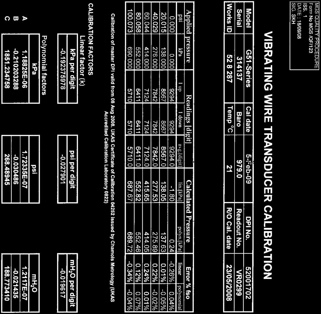
42 29 RIVENHALL GROUND INVESTIGATION APPENDIX C Vibrating Wire Installation Information February 21 Report No /B.


43 » readouts datalogers terminal stations VW216 Vibrating Wire Readout The portable VW216 Vibrating Wire Readout reads, displays, and logs both vibrating wire sensors and thermistors. Vibrating wire load cells can be read without any additional accessories. Unprecedented accuracy, flexible memory options and ease of use make the VW216 invaluable for projects requiring vibrating wire sensor monitoring. Maximum download time is only 15 seconds. Complementing its high level of accuracy, the VW216 is also designed for maximum efficiency with the user in mind. In addition to the simple power requirements of only 3 AA batteries, the VW216 comes well-equipped with standard features such as a large graphics display with backlight, a built-in multiplexer, no-tools vibrating wire transducer inputs (eliminating the need for alligator clips), and a convenient on-board speaker for sensor diagnostics. Offical RST distributor in Europe & MENA Geotechnical Centre Rougham Industrial Estate Rougham, Bury St Edmunds Suffolk IP3 9ND ENGLAND Telephone: +44() Facsimile: +44() Geosense is a division of Marton Geotechnical Services Ltd info@mgsgeosense.co.uk ISO 91:2 REGISTERED QUALITY SYSTEM VW216 Vibrating Wire Readout shown with Vibrating Wire Piezometer specs DESCRIPTION Vibrating Wire Readout Excitation Range Vibrating Wire Readout Resolution Vibrating Wire Readout Timebase Accuracy Supported Temperature Readout Sensors Temperature Readout Accuracy Temperature Readout Range Display Display Backlight Max Instrument Locations Memory Capacity Location Identification String Download Speed Battery Battery Indicator SPECIFICATION 4 Hz to 6 Hz, 5 V Square Wave.1 µs ±5 ppm NTC3 (standard), NTC2252, NTC1K, RTD ±.1 C -5 C to 8 C Graphic 128 x 64 pixels large character display High efficiency LCD with auto off ,4 custom labelled points Up to 2 characters 15 seconds (full memory) 3 AA alkaline On-screen, low battery indicator Operating Temperature -2 C to 6 C Dimensions W 22 cm x D 19 cm x H 9.5 cm (8.75 x 7.5 x 3.75in.) Weight 1.1 kg (2.4 lbs) applications Reads, displays, and logs both vibrating wire sensors and thermistors. features Durable, compact design for excellent portability and field use. Large graphics display with a convenient backlight. Readings in raw or engineering units. Built-in multiplexer for load cells up to 6 vibrating wire gauges. No-tools vibrating wire transducer inputs eliminates the need for alligator clips. Field-replaceable AA alkaline batteries eliminate the need for a large, bulky 12 V battery and a charger. On-board speaker for sensor diagnostics. Stores up to 254 instrument locations per route, each with a text label, calibration constants, previous data, and up to 11,4 time/date stamped data points. Data transfer to a host computer via USB in a compatible file format for Microsoft Excel and other spreadsheets. User friendly host software for Microsoft Windows included. ordering info PART # VW216 DESCRIPTION Vibrating Wire Readout MIB33I RST Instruments Ltd. reserves the right to change specifications without notice. Windows and Microsoft Excel are registered trademarks of the Microsoft Corporation.


44

45
46 29 RIVENHALL GROUND INVESTIGATION APPENDIX D GEOLABS Analysis Results February 21 Report No /B.
47 Date 24/7/29 PROJECT NAME RIVENHALL Approved J Sturges PROJECT NO: GEO / 1472 Page 1 of 5 Sample details Classification Tests Density Tests Undrained Triaxial Compression Tests Chemical Tests Mean Angle of 2:1 Ground Borehole Depth No. Type Description MC LL PL PI <425 Bulk Dry Cell Deviator Shear Apparent Shearing ph W/S Water Other tests and comments mic Pressure Stress Stress Cohesion Resistance SO4 SO4 No. (m) (Mg/m³)(Mg/m³) (kpa) (kpa) (kpa) (kpa) (º) (g/l) (g/l) RBH B Orange-brown slightly clayey silty SAND and GRAVEL Particle Size Distribution Test Chemical Testing RBH U Stiff fissured dark grey CLAY Oedometer Consolidation Test 4 56 RBH U Very stiff closely fissured dark grey CLAY Oedometer Consolidation Test Effective Stress Triaxial Test SUMMARY OF GEOTECHNICAL TESTING GEOLABS Test Report by GEOLABS Limited Bucknalls Lane, Garston, Watford, Hertfordshire, WD25 9XX Ref: Page 1 of 5 Authorised Signatories: J R Masters (Qual Mgr) C F Wallace (Tech Mgr) G J Corio (Tech Mgr) [X] J Sturges (Tech Mgr) R J Platt (Snr Tech) J J M Powell (Tech Dir) GEOLABS LIMITED Client: Golder Associates (UK) Limited, Kensal House, 77 Springfield Road, Chelmsford CM2 6JG RBH D Light brown slightly gravelly CLAY, 17 gravel is fine to medium chalk RBH U Firm to stiff brown gravelly CLAY, gravel is fine Chemical Testing to coarse flint and chalk RBH D Light brown slightly gravelly CLAY, 15 gravel is fine to medium chalk RBH D Dark brown slightly gravelly CLAY, 11 gravel is fine to medium RBH B Dark brown CLAY RBH D Dark grey CLAY 25 RBH D Dark grey CLAY 32 RBH D Dark grey CLAY RBH D Dark grey CLAY 3
48 Date 24/7/29 PROJECT NAME RIVENHALL Approved J Sturges PROJECT NO: GEO / 1472 Page 2 of 5 Sample details Classification Tests Density Tests Undrained Triaxial Compression Tests Chemical Tests Mean Angle of 2:1 Ground Borehole Depth No. Type Description MC LL PL PI <425 Bulk Dry Cell Deviator Shear Apparent Shearing ph W/S Water Other tests and comments mic Pressure Stress Stress Cohesion Resistance SO4 SO4 No. (m) (Mg/m³) (Mg/m³) (kpa) (kpa) (kpa) (kpa) (º) (g/l) (g/l) RBH B Orange-brown slightly silty slightly Particle Size Distribution Test clayey SAND and GRAVEL Chemical Testing RBH U Stiff light brown gravelly clayey SAND Chemical Testing RBH D Sample not received Sample not received RBH B Orange-brown clayey very sandy GRAVEL Particle Size Distribution Test RBH U Firm closely fissured dark grey CLAY Chemical Testing with rare pyrite nodules SUMMARY OF GEOTECHNICAL TESTING GEOLABS Test Report by GEOLABS Limited Bucknalls Lane, Garston, Watford, Hertfordshire, WD25 9XX Ref: Page 2 of 5 Authorised Signatories: J R Masters (Qual Mgr) C F Wallace (Tech Mgr) G J Corio (Tech Mgr) [X] J Sturges (Tech Mgr) R J Platt (Snr Tech) J J M Powell (Tech Dir) GEOLABS LIMITED Client: Golder Associates (UK) Limited, Kensal House, 77 Springfield Road, Chelmsford CM2 6JG RBH D Dark grey CLAY 28 RBH3.5 - D Light brown slightly sandy CLAY RBH U Light brown gravelly CLAY, gravel is fine to medium chalk RBH D Light brown gravelly CLAY, 19 gravel is fine to medium chalk RBH D Light brown gravelly CLAY, 17 gravel is fine to medium chalk RBH D Light brown gravelly CLAY, gravel is fine to medium chalk RBH D Grey CLAY 29
49 Date 24/7/29 PROJECT NAME RIVENHALL Approved J Sturges PROJECT NO: GEO / 1472 Page 3 of 5 Sample details Classification Tests Density Tests Undrained Triaxial Compression Tests Chemical Tests Mean Angle of 2:1 Ground Borehole Depth No. Type Description MC LL PL PI <425 Bulk Dry Cell Deviator Shear Apparent Shearing ph W/S Water Other tests and comments mic Pressure Stress Stress Cohesion Resistance SO4 SO4 No. (m) (Mg/m³) (Mg/m³) (kpa) (kpa) (kpa) (kpa) (º) (g/l) (g/l) RBH U Very stiff closely fissured dark grey CLAY Oedometer Consolidation Test Effective Stress Triaxial Test RBH Chemical Testing - D Grey CLAY Effective Stress Triaxial Test RBH U Very stiff fissured dark grey CLAY Oedometer Consolidation Test Effective Stress Triaxial Test RBH D Orange-brown slightly sandy slightly gravelly CLAY, 19 Particle Density = 2.72 Mg/m³ gravel is fine to coarse chalk RBH D Orange-brown slightly sandy gravelly CLAY, kg Compaction Test gravel is fine to coarse chalk nodules Test Report by GEOLABS Limited Bucknalls Lane, Garston, Watford, Hertfordshire, WD25 9XX Ref: Page 3 of 5 Authorised Signatories: J R Masters (Qual Mgr) C F Wallace (Tech Mgr) G J Corio (Tech Mgr) [X] J Sturges (Tech Mgr) R J Platt (Snr Tech) J J M Powell (Tech Dir) GEOLABS LIMITED Client: Golder Associates (UK) Limited, Kensal House, 77 Springfield Road, Chelmsford CM2 6JG RBH D Grey CLAY 28 RBH D Grey CLAY 27 RBH D Grey CLAY RBH D Grey CLAY 3 RBH D Brown slightly sandy gravelly CLAY, gravel is fine to medium chalk RBH D Brown slightly sandy gravelly CLAY, 18 gravel is fine to medium chalk RBH D Light brown slightly sandy gravelly CLAY, 15 gravel is fine to medium chalk SUMMARY OF GEOTECHNICAL TESTING GEOLABS
50 Date 24/7/29 PROJECT NAME RIVENHALL Approved J Sturges PROJECT NO: GEO / 1472 Page 4 of 5 Sample details Classification Tests Density Tests Undrained Triaxial Compression Tests Chemical Tests Mean Angle of 2:1 Ground Borehole Depth No. Type Description MC LL PL PI <425 Bulk Dry Cell Deviator Shear Apparent Shearing ph W/S Water Other tests and comments mic Pressure Stress Stress Cohesion Resistance SO4 SO4 No. (m) (Mg/m³) (Mg/m³) (kpa) (kpa) (kpa) (kpa) (º) (g/l) (g/l) RBH U Firm brown slightly sandy gravel CLAY Chemical Testing Sample failed at 2% strain RBH B Light brown slightly gravelly clayey silty SAND Particle Size Distribution Test Chemical Testing RBH B Orange-brown slightly clayey very sandy GRAVEL Particle Size Distribution Test RBH U Dark grey fissured CLAY Chemical Testing RBH D Dark grey CLAY with rare bands of mudstone kg Compaction Test Particle Density = 2.76 Mg/m³ SUMMARY OF GEOTECHNICAL TESTING GEOLABS Test Report by GEOLABS Limited Bucknalls Lane, Garston, Watford, Hertfordshire, WD25 9XX Ref: Page 4 of 5 Authorised Signatories: J R Masters (Qual Mgr) C F Wallace (Tech Mgr) G J Corio (Tech Mgr) [X] J Sturges (Tech Mgr) R J Platt (Snr Tech) J J M Powell (Tech Dir) GEOLABS LIMITED Client: Golder Associates (UK) Limited, Kensal House, 77 Springfield Road, Chelmsford CM2 6JG RBH D Light brown orange sandy CLAY 18 RBH D Brown CLAY 55 RBH D Dark grey fissured CLAY 27 RBH D Dark grey fissured CLAY 28 RBH D Dark grey fissured CLAY RBH D Dark grey fissured CLAY 24 RBH D Dark grey fissured CLAY 28
51 Date 24/7/29 PROJECT NAME RIVENHALL Approved J Sturges PROJECT NO: GEO / 1472 Page 5 of 5 Sample details Classification Tests Density Tests Undrained Triaxial Compression Tests Chemical Tests Mean Angle of 2:1 Ground Borehole Depth No. Type Description MC LL PL PI <425 Bulk Dry Cell Deviator Shear Apparent Shearing ph W/S Water Other tests and comments mic Pressure Stress Stress Cohesion Resistance SO4 SO4 No. (m) (Mg/m³) (Mg/m³) (kpa) (kpa) (kpa) (kpa) (º) (g/l) (g/l) RBH U Dark grey fissured CLAY 31 Chemical Testing SUMMARY OF GEOTECHNICAL TESTING GEOLABS Test Report by GEOLABS Limited Bucknalls Lane, Garston, Watford, Hertfordshire, WD25 9XX Ref: Page 5 of 5 Authorised Signatories: J R Masters (Qual Mgr) C F Wallace (Tech Mgr) G J Corio (Tech Mgr) [X] J Sturges (Tech Mgr) R J Platt (Snr Tech) J J M Powell (Tech Dir) GEOLABS LIMITED Client: Golder Associates (UK) Limited, Kensal House, 77 Springfield Road, Chelmsford CM2 6JG RBH D Dark grey fissured CLAY RBH D Stiff dark grey CLAY RBH D Dark grey fissured CLAY 28
52 BS1377 : Part 2 : Clause 9 : 199 Determination of Particle Size Distribution Borehole Number: RBH2 Description: Sample Number: - Orange-brown slightly clayey silty SAND and GRAVEL Depth (m): Sieve SIEVE % pass 2 mm mm 1 9 mm 1 75 mm 1 63 mm 1 5 mm mm 1 28 mm 99 2 mm mm 9 1 mm mm 77 5 mm mm 71 2 mm mm 6 6 µm 52 BS1377 : Part 2 : Clause 9.2 : 199 Wet Sieving Method BS1377 : Part 2 : Clause 9.4 : 199 Sedimentation by the Pipette Method 425 µm 45 Particle Proportions 3 µm 33 Cobbles. % 212 µm 25 Gravel 34.5 % 15 µm 2 Sand 51.8 % 63 µm 14 Silt 11.5 % PIPETTE Particle size % pass 2. µm µm 6 2. µm 2 Preparation: No Pre-treatment used Percentage Passing SILT SAND GRAVEL Fine Medium Coarse Fine Medium Coarse Fine Medium Coarse CLAY Particle Size (mm) Clay 2.2 % COBBLES Temp ( C) 2 Checked and Approved Initials: Date: 24/7/29 Project Number: GEO / 1472 JS Project Name: RIVENHALL GEOLABS Test Report by GEOLABS Limited Bucknalls Lane, Garston, Watford, Hertfordshire, WD25 9XX (Ref ) Page 1 of 1 Authorised Signatories: J R Masters (Qual Mgr) C F Wallace (Tech Mgr) G J Corio (Tech Mgr) [X] J Sturges (Tech Mgr) R Platt (Snr Tech) GEOLABS LIMITED Client: Golder Associates (UK) Limited, Kensal House, 77 Springfield Road, Chelmsford CM2 6JG
53 BS1377 : Part 2 : Clause 9 : 199 Determination of Particle Size Distribution Borehole Number: RBH3 Description: Sample Number: - Orange-brown slightly silty slightly clayey SAND and GRAVEL Depth (m): BS1377 : Part 2 : Clause 9.3 : 199 Dry Sieving Method Sieve SIEVE % pass 2 mm mm 1 9 mm 1 75 mm 1 63 mm 1 5 mm mm 1 28 mm 99 2 mm mm 88 1 mm mm 69 5 mm mm 61 2 mm mm 53 6 µm 47 Percentage Passing SILT SAND GRAVEL Fine Medium Coarse Fine Medium Coarse Fine Medium Coarse CLAY Particle Size (mm) 425 µm 4 Particle Proportions 3 µm 26 Cobbles. % 212 µm 15 Gravel 44.2 % 15 µm 9 Sand 5.7 % 63 µm 5 Silt & Clay 5.1 % COBBLES Checked and Approved Initials: Date: 24/7/29 Project Number: GEO / 1472 JS Project Name: RIVENHALL GEOLABS Test Report by GEOLABS Limited Bucknalls Lane, Garston, Watford, Hertfordshire, WD25 9XX (Ref ) Page 1 of 1 Authorised Signatories: J R Masters (Qual Mgr) C F Wallace (Tech Mgr) G J Corio (Tech Mgr) [X] J Sturges (Tech Mgr) R Platt (Snr Tech) GEOLABS LIMITED Client: Golder Associates (UK) Limited, Kensal House, 77 Springfield Road, Chelmsford CM2 6JG
54 BS1377 : Part 2 : Clause 9 : 199 Determination of Particle Size Distribution Borehole Number: RBH3 Description: Sample Number: - Orange-brown clayey very sandy GRAVEL Depth (m): BS1377 : Part 2 : Clause 9.2 : 199 Wet Sieving Method Sieve SIEVE % pass 2 mm mm 1 9 mm 1 75 mm 1 63 mm 1 5 mm mm mm 85 2 mm mm 64 1 mm mm 49 5 mm mm 43 2 mm mm 36 6 µm 24 Percentage Passing SILT SAND GRAVEL Fine Medium Coarse Fine Medium Coarse Fine Medium Coarse CLAY Particle Size (mm) 425 µm 14 Particle Proportions 3 µm 1 Cobbles. % 212 µm 9 Gravel 6.7 % 15 µm 8 Sand 32.8 % 63 µm 6 Silt & Clay 6.4 % COBBLES Checked and Approved Initials: Date: 24/7/29 Project Number: GEO / 1472 JS Project Name: RIVENHALL GEOLABS Test Report by GEOLABS Limited Bucknalls Lane, Garston, Watford, Hertfordshire, WD25 9XX (Ref ) Page 1 of 1 Authorised Signatories: J R Masters (Qual Mgr) C F Wallace (Tech Mgr) G J Corio (Tech Mgr) [X] J Sturges (Tech Mgr) R Platt (Snr Tech) GEOLABS LIMITED Client: Golder Associates (UK) Limited, Kensal House, 77 Springfield Road, Chelmsford CM2 6JG
55 BS1377 : Part 2 : Clause 9 : 199 Determination of Particle Size Distribution Borehole Number: RBH4 Description: Sample Number: - Light brown slightly gravelly clayey silty SAND Depth (m): Sieve SIEVE % pass 2 mm mm 1 9 mm 1 75 mm 1 63 mm 1 5 mm mm 1 28 mm 1 2 mm 1 14 mm 99 1 mm mm 96 5 mm mm 95 2 mm mm 94 6 µm 93 BS1377 : Part 2 : Clause 9.2 : 199 Wet Sieving Method BS1377 : Part 2 : Clause 9.4 : 199 Sedimentation by the Pipette Method 425 µm 9 Particle Proportions 3 µm 74 Cobbles. % 212 µm 55 Gravel 5.3 % 15 µm 37 Sand 71. % 63 µm 24 Silt 14.4 % PIPETTE Particle size % pass 2. µm 2 6. µm µm 9 Preparation: No Pre-treatment used Percentage Passing SILT SAND GRAVEL Fine Medium Coarse Fine Medium Coarse Fine Medium Coarse CLAY Particle Size (mm) Clay 9.3 % COBBLES Temp ( C) 2 Checked and Approved Initials: Date: 24/7/29 Project Number: GEO / 1472 JS Project Name: RIVENHALL GEOLABS Test Report by GEOLABS Limited Bucknalls Lane, Garston, Watford, Hertfordshire, WD25 9XX (Ref ) Page 1 of 1 Authorised Signatories: J R Masters (Qual Mgr) C F Wallace (Tech Mgr) G J Corio (Tech Mgr) [X] J Sturges (Tech Mgr) R Platt (Snr Tech) GEOLABS LIMITED Client: Golder Associates (UK) Limited, Kensal House, 77 Springfield Road, Chelmsford CM2 6JG
56 BS1377 : Part 2 : Clause 9 : 199 Determination of Particle Size Distribution Borehole Number: RBH4 Description: Sample Number: - Orange-brown slightly clayey very sandy GRAVEL Depth (m): BS1377 : Part 2 : Clause 9.3 : 199 Dry Sieving Method Sieve SIEVE % pass 2 mm mm 1 9 mm 1 75 mm 1 63 mm 1 5 mm mm mm 94 2 mm mm 69 1 mm mm 45 5 mm mm 32 2 mm mm 2 6 µm 15 Percentage Passing SILT SAND GRAVEL Fine Medium Coarse Fine Medium Coarse Fine Medium Coarse CLAY Particle Size (mm) 425 µm 12 Particle Proportions 3 µm 9 Cobbles. % 212 µm 7 Gravel 75.3 % 15 µm 5 Sand 21.2 % 63 µm 4 Silt & Clay 3.6 % COBBLES Checked and Approved Initials: Date: 24/7/29 Project Number: GEO / 1472 JS Project Name: RIVENHALL GEOLABS Test Report by GEOLABS Limited Bucknalls Lane, Garston, Watford, Hertfordshire, WD25 9XX (Ref ) Page 1 of 1 Authorised Signatories: J R Masters (Qual Mgr) C F Wallace (Tech Mgr) G J Corio (Tech Mgr) [X] J Sturges (Tech Mgr) R Platt (Snr Tech) GEOLABS LIMITED Client: Golder Associates (UK) Limited, Kensal House, 77 Springfield Road, Chelmsford CM2 6JG
57
58
59
60
61
62
63
64
65 BS1377 : Part 8 : Clause 7 : 199 and Technical Procedure TP38 Consolidated Undrained Multistage Triaxial Compression Test with Measurement of Pore Pressure Description: Borehle Number: RBH2 Very stiff dark brown CLAY Depth (m): SPECIMEN DETAILS Depth within original sample Orientation within original sample 5mm from top Vertical TEST DETAILS Specimen Preparation Undisturbed Cell Preparation Checks performed in accordance with Clause 3.5 Specimen Number Multistage Initial Diameter mm 86.2 Initial Length mm 175. Initial Moisture Content % 29 Initial Wet Density Mg/m³ 1.95 Drainage Conditions Stage 1: one end and radial boundary Stages 2 & 3: Both ends and radial boundary SATURATION STAGE Final Cell Pressure kpa 8 Final Pore Pressure kpa 679 Final Pore Pressure Parameter B.98 Duration day(s) 5 CONSOLIDATION STAGE Stage No 1 Stage No 2 Stage No 3 Cell Pressure kpa Back Pressure kpa 4 single 4 double 3 double Effective Pressure kpa 4 ended 8 ended 14 ended Final Pore Pressure kpa Test Terminated Final Pore Pressure Dissipation % Duration day(s) SHEARING STAGE Cell Pressure kpa 8 12 Rate of Axial Displacement mm/min.8.6 Initial Pore Pressure kpa Initial Effective Stress kpa CONDITIONS AT FAILURE criteria Maximum Principal Stress Ratio Pore Pressure kpa Minor Effective Principal Stress kpa Deviator Stress kpa Major Effective Principal Stress kpa Effective Principal Stress Ratio Pore Pressure Parameter A Axial Strain % Correction applied to Deviator Stress kpa 5 5 Duration : charged / actual day(s) 6 / 12 1 Final Moisture Content % 27 Final Wet Density Mg/m³ 2.2 EFFECTIVE STRESS PARAMETERS Cohesion kpa 48 Angle of Shear Resistance degrees 17.5 FAILURE SKETCH Checked and Approved Project Number: GEO / 1472 Initials: Project Name: GEOLABS CFW RIVENHALL Date: 18/9/9 Test Report by GEOLABS Limited Bucknalls Lane, Garston, Watford, Hertfordshire, WD25 9XX (Ref ) Page 1 of 1 Authorised Signatories: J R Masters (Qual Mgr) [x] C F Wallace (Tech Mgr) G J Corio (Tech Mgr) R Platt (Snr Tech) GEOLABS LIMITED Client: Golder Associates (UK) Limited, Kensal House, 77 Springfield Road, Chelmsford CM2 6JG
66 BS1377 : Part 8 : Clause 7 : 199 and Technical Procedure TP38 Consolidated Undrained Multistage Triaxial Compression Test with Measurement of Pore Pressure Description: Borehle Number: RBH2 Very stiff dark brown CLAY Depth (m): Shear Stress, t' (kpa) Effective Principal Stress, s' (kpa) 6 Shear Stress (kpa) Effective Principal Stress (kpa) Checked and Approved Project Number: GEO / 1472 Initials: Project Name: GEOLABS CFW RIVENHALL Date: 18/9/9 Test Report by GEOLABS Limited Bucknalls Lane, Garston, Watford, Hertfordshire, WD25 9XX (Ref ) Page 1 of 1 Authorised Signatories: J R Masters (Qual Mgr) [x] C F Wallace (Tech Mgr) G J Corio (Tech Mgr) R Platt (Snr Tech) GEOLABS LIMITED Client: Golder Associates (UK) Limited, Kensal House, 77 Springfield Road, Chelmsford CM2 6JG
67 BS1377 : Part 8 : Clause 7 : 199 and Technical Procedure TP38 Consolidated Undrained Multistage Triaxial Compression Test with Measurement of Pore Pressure Borehle Number: RBH2 Stage No 1 Depth (m): Pore Pressure (kpa) Cell Pressure (kpa) Volume Change (ml) Square Root of Time (min) Pore Pressure (kpa) Deviator Stress (kpa) Principal Stress Ratio Axial Strain Checked and Approved Project Number: GEO / 1472 Initials: Project Name: GEOLABS CFW RIVENHALL Date: 18/9/9 Test Report by GEOLABS Limited Bucknalls Lane, Garston, Watford, Hertfordshire, WD25 9XX (Ref ) Page 1 of 1 Authorised Signatories: J R Masters (Qual Mgr) [x] C F Wallace (Tech Mgr) G J Corio (Tech Mgr) R Platt (Snr Tech) GEOLABS LIMITED Client: Golder Associates (UK) Limited, Kensal House, 77 Springfield Road, Chelmsford CM2 6JG
68 BS1377 : Part 8 : Clause 7 : 199 and Technical Procedure TP38 Consolidated Undrained Multistage Triaxial Compression Test with Measurement of Pore Pressure Borehle Number: RBH2 Stage No 2 Depth (m): Volume Change (ml) Square Root of Time (min) 7 Pore Pressure (kpa) Deviator Stress (kpa) Principal Stress Ratio Axial Strain Checked and Approved Project Number: GEO / 1472 Initials: Project Name: GEOLABS CFW RIVENHALL Date: 18/9/9 Test Report by GEOLABS Limited Bucknalls Lane, Garston, Watford, Hertfordshire, WD25 9XX (Ref ) Page 1 of 1 Authorised Signatories: J R Masters (Qual Mgr) [x] C F Wallace (Tech Mgr) G J Corio (Tech Mgr) R Platt (Snr Tech) GEOLABS LIMITED Client: Golder Associates (UK) Limited, Kensal House, 77 Springfield Road, Chelmsford CM2 6JG
69 BS1377 : Part 8 : Clause 7 : 199 and Technical Procedure TP38 Consolidated Undrained Multistage Triaxial Compression Test with Measurement of Pore Pressure Borehole Number: RBH3 Description: Sample Number: U Very stiff brown CLAY. Depth (m): SPECIMEN DETAILS Depth within original sample Orientation within original sample 1 mm from top Vertical TEST DETAILS Specimen Preparation Undisturbed Cell Preparation Checks performed in accordance with Clause 3.5 Specimen Number Multistage Initial Diameter mm 94.9 Initial Length mm Initial Moisture Content % 3 Initial Wet Density Mg/m³ 1.96 Drainage Conditions Stage 1 & 2: one end and radial boundary Stage 3: Both ends and radial boundary SATURATION STAGE Final Cell Pressure kpa 75 Final Pore Pressure kpa 666 Final Pore Pressure Parameter B.98 Duration day(s) 4 CONSOLIDATION STAGE Stage No 1 Stage No 2 Stage No 3 Cell Pressure kpa Back Pressure kpa 5 single 5 single 5 double Effective Pressure kpa 25 ended 5 ended 1 ended Final Pore Pressure kpa Final Pore Pressure Dissipation % Duration day(s) SHEARING STAGE Cell Pressure kpa Rate of Axial Displacement mm/min Initial Pore Pressure kpa Initial Effective Stress kpa CONDITIONS AT FAILURE criteria Maximum Principal Stress Ratio Pore Pressure kpa Minor Effective Principal Stress kpa Deviator Stress kpa Major Effective Principal Stress kpa Effective Principal Stress Ratio Pore Pressure Parameter A Axial Strain % Correction applied to Deviator Stress kpa Duration day(s) Final Moisture Content % 3 Final Wet Density Mg/m³ 2.16 EFFECTIVE STRESS PARAMETERS Cohesion kpa 19 Angle of Shear Resistance degrees 19 FAILURE SKETCH Checked and Approved Project Number: GEO / 1472 Initials: Project Name: GEOLABS CFW RIVENHALL Date: 18/9/9 Test Report by GEOLABS Limited Bucknalls Lane, Garston, Watford, Hertfordshire, WD25 9XX (Ref ) Page 1 of 1 Authorised Signatories: J R Masters (Qual Mgr) [x] C F Wallace (Tech Mgr) G J Corio (Tech Mgr) R Platt (Snr Tech) GEOLABS LIMITED Client: Golder Associates (UK) Limited, Kensal House, 77 Springfield Road, Chelmsford CM2 6JG
70 BS1377 : Part 8 : Clause 7 : 199 and Technical Procedure TP38 Consolidated Undrained Multistage Triaxial Compression Test with Measurement of Pore Pressure Borehole Number: RBH3 Description: Sample Number: U Very stiff brown CLAY. Depth (m): Shear Stress, t' (kpa) Effective Principal Stress, s' (kpa) 1 8 Shear Stress (kpa) Effective Principal Stress (kpa) Checked and Approved Project Number: GEO / 1472 Initials: Project Name: GEOLABS CFW RIVENHALL Date: 18/9/9 Test Report by GEOLABS Limited Bucknalls Lane, Garston, Watford, Hertfordshire, WD25 9XX (Ref ) Page 1 of 1 Authorised Signatories: J R Masters (Qual Mgr) [x] C F Wallace (Tech Mgr) G J Corio (Tech Mgr) R Platt (Snr Tech) GEOLABS LIMITED Client: Golder Associates (UK) Limited, Kensal House, 77 Springfield Road, Chelmsford CM2 6JG
71 BS1377 : Part 8 : Clause 7 : 199 and Technical Procedure TP38 Consolidated Undrained Multistage Triaxial Compression Test with Measurement of Pore Pressure Borehole Number: RBH3 Sample Number: U Stage No 1 Depth (m): Pore Pressure (kpa) Cell Pressure (kpa) Volume Change (ml) Square Root of Time (min) Pore Pressure (kpa) Deviator Stress (kpa) Principal Stress Ratio Axial Strain Checked and Approved Project Number: GEO / 1472 Initials: Project Name: GEOLABS CFW RIVENHALL Date: 18/9/9 Test Report by GEOLABS Limited Bucknalls Lane, Garston, Watford, Hertfordshire, WD25 9XX (Ref ) Page 1 of 1 Authorised Signatories: J R Masters (Qual Mgr) [x] C F Wallace (Tech Mgr) G J Corio (Tech Mgr) R Platt (Snr Tech) GEOLABS LIMITED Client: Golder Associates (UK) Limited, Kensal House, 77 Springfield Road, Chelmsford CM2 6JG
72 BS1377 : Part 8 : Clause 7 : 199 and Technical Procedure TP38 Consolidated Undrained Multistage Triaxial Compression Test with Measurement of Pore Pressure Borehole Number: RBH3 Sample Number: U Stage No 2 Depth (m): Volume Change (ml) Square Root of Time (min) 7 Pore Pressure (kpa) Deviator Stress (kpa) Principal Stress Ratio Axial Strain Checked and Approved Project Number: GEO / 1472 Initials: Project Name: GEOLABS CFW RIVENHALL Date: 18/9/9 Test Report by GEOLABS Limited Bucknalls Lane, Garston, Watford, Hertfordshire, WD25 9XX (Ref ) Page 1 of 1 Authorised Signatories: J R Masters (Qual Mgr) [x] C F Wallace (Tech Mgr) G J Corio (Tech Mgr) R Platt (Snr Tech) GEOLABS LIMITED Client: Golder Associates (UK) Limited, Kensal House, 77 Springfield Road, Chelmsford CM2 6JG
73 BS1377 : Part 8 : Clause 7 : 199 and Technical Procedure TP38 Consolidated Undrained Multistage Triaxial Compression Test with Measurement of Pore Pressure Borehole Number: RBH3 Sample Number: U Stage No 3 Depth (m): Volume Change (ml) Square Root of Time (min) 1 Pore Pressure (kpa) Deviator Stress (kpa) Principal Stress Ratio Axial Strain Checked and Approved Project Number: GEO / 1472 Initials: Project Name: GEOLABS CFW RIVENHALL Date: 18/9/9 Test Report by GEOLABS Limited Bucknalls Lane, Garston, Watford, Hertfordshire, WD25 9XX (Ref ) Page 1 of 1 Authorised Signatories: J R Masters (Qual Mgr) [x] C F Wallace (Tech Mgr) G J Corio (Tech Mgr) R Platt (Snr Tech) GEOLABS LIMITED Client: Golder Associates (UK) Limited, Kensal House, 77 Springfield Road, Chelmsford CM2 6JG
74 BS1377 : Part 8 : Clause 7 : 199 and Technical Procedure TP38 Consolidated Undrained Multistage Triaxial Compression Test with Measurement of Pore Pressure Description: Borehle Number: RBH3 Stiff dark grey and brown CLAY. Depth (m): SPECIMEN DETAILS Depth within original sample Orientation within original sample 1mm from top Vertical TEST DETAILS Specimen Preparation Undisturbed Cell Preparation Checks performed in accordance with Clause 3.5 Specimen Number Multistage Initial Diameter mm 67.7 Initial Length mm Initial Moisture Content % 29 Initial Wet Density Mg/m³ 1.91 Drainage Conditions One end and radial boundary - all stages single ended SATURATION STAGE Final Cell Pressure kpa 75 Final Pore Pressure kpa 71 Final Pore Pressure Parameter B.97 Duration day(s) 6 CONSOLIDATION STAGE Stage No 1 Stage No 2 Stage No 3 Cell Pressure kpa Back Pressure kpa Effective Pressure kpa Final Pore Pressure kpa Final Pore Pressure Dissipation % Duration day(s) SHEARING STAGE Cell Pressure kpa Rate of Axial Displacement mm/min Initial Pore Pressure kpa Initial Effective Stress kpa CONDITIONS AT FAILURE criteria Maximum Principal Stress Ratio Pore Pressure kpa Minor Effective Principal Stress kpa Deviator Stress kpa Major Effective Principal Stress kpa Effective Principal Stress Ratio Pore Pressure Parameter A Axial Strain % Correction applied to Deviator Stress kpa Duration: charged / actual day(s) 3 / Final Moisture Content % 27 Final Wet Density Mg/m³ 2.22 EFFECTIVE STRESS PARAMETERS Cohesion kpa 71 Angle of Shear Resistance degrees 18 FAILURE SKETCH Checked and Approved Project Number: GEO / 1472 Initials: Project Name: GEOLABS RJP RIVENHALL Date: 21/9/9 Test Report by GEOLABS Limited Bucknalls Lane, Garston, Watford, Hertfordshire, WD25 9XX (Ref ) Page 1 of 1 Authorised Signatories: J R Masters (Qual Mgr) C F Wallace (Tech Mgr) G J Corio (Tech Mgr) R Platt (Snr Tech) GEOLABS LIMITED Client: Golder Associates (UK) Limited, Kensal House, 77 Springfield Road, Chelmsford CM2 6JG
75 BS1377 : Part 8 : Clause 7 : 199 and Technical Procedure TP38 Consolidated Undrained Multistage Triaxial Compression Test with Measurement of Pore Pressure Description: Borehle Number: RBH3 Stiff dark grey and brown CLAY. Depth (m): Shear Stress, t' (kpa) Effective Principal Stress, s' (kpa) 1 8 Shear Stress (kpa) Effective Principal Stress (kpa) Checked and Approved Project Number: GEO / 1472 Initials: Project Name: GEOLABS RJP RIVENHALL Date: 21/9/9 Test Report by GEOLABS Limited Bucknalls Lane, Garston, Watford, Hertfordshire, WD25 9XX (Ref ) Page 1 of 1 Authorised Signatories: J R Masters (Qual Mgr) C F Wallace (Tech Mgr) G J Corio (Tech Mgr) R Platt (Snr Tech) GEOLABS LIMITED Client: Golder Associates (UK) Limited, Kensal House, 77 Springfield Road, Chelmsford CM2 6JG
76 BS1377 : Part 8 : Clause 7 : 199 and Technical Procedure TP38 Consolidated Undrained Multistage Triaxial Compression Test with Measurement of Pore Pressure Borehle Number: RBH3 Stage No 1 Depth (m): Pore Pressure (kpa) Cell Pressure (kpa) Volume Change (ml) Square Root of Time (min) Pore Pressure (kpa) Deviator Stress (kpa) Principal Stress Ratio Axial Strain Checked and Approved Project Number: GEO / 1472 Initials: Project Name: GEOLABS RJP RIVENHALL Date: 21/9/9 Test Report by GEOLABS Limited Bucknalls Lane, Garston, Watford, Hertfordshire, WD25 9XX (Ref ) Page 1 of 1 Authorised Signatories: J R Masters (Qual Mgr) C F Wallace (Tech Mgr) G J Corio (Tech Mgr) R Platt (Snr Tech) GEOLABS LIMITED Client: Golder Associates (UK) Limited, Kensal House, 77 Springfield Road, Chelmsford CM2 6JG
77 BS1377 : Part 8 : Clause 7 : 199 and Technical Procedure TP38 Consolidated Undrained Multistage Triaxial Compression Test with Measurement of Pore Pressure Borehle Number: RBH3 Stage No 2 Depth (m): Volume Change (ml) Square Root of Time (min) 8 Pore Pressure (kpa) Deviator Stress (kpa) Principal Stress Ratio Axial Strain Checked and Approved Project Number: GEO / 1472 Initials: Project Name: GEOLABS RJP RIVENHALL Date: 21/9/9 Test Report by GEOLABS Limited Bucknalls Lane, Garston, Watford, Hertfordshire, WD25 9XX (Ref ) Page 1 of 1 Authorised Signatories: J R Masters (Qual Mgr) C F Wallace (Tech Mgr) G J Corio (Tech Mgr) R Platt (Snr Tech) GEOLABS LIMITED Client: Golder Associates (UK) Limited, Kensal House, 77 Springfield Road, Chelmsford CM2 6JG
78 BS1377 : Part 8 : Clause 7 : 199 and Technical Procedure TP38 Consolidated Undrained Multistage Triaxial Compression Test with Measurement of Pore Pressure Borehle Number: RBH3 Stage No 3 Depth (m): Volume Change (ml) Square Root of Time (min) 12 Pore Pressure (kpa) Deviator Stress (kpa) Principal Stress Ratio Axial Strain Checked and Approved Project Number: GEO / 1472 Initials: Project Name: GEOLABS RJP RIVENHALL Date: 21/9/9 Test Report by GEOLABS Limited Bucknalls Lane, Garston, Watford, Hertfordshire, WD25 9XX (Ref ) Page 1 of 1 Authorised Signatories: J R Masters (Qual Mgr) C F Wallace (Tech Mgr) G J Corio (Tech Mgr) R Platt (Snr Tech) GEOLABS LIMITED Client: Golder Associates (UK) Limited, Kensal House, 77 Springfield Road, Chelmsford CM2 6JG
79 BS1377 : Part 8 : Clause 7 : 199 and Technical Procedure TP38 Consolidated Undrained Multistage Triaxial Compression Test with Measurement of Pore Pressure Borehole Number: RBH3 Description: Sample Number: U Very stiff brown CLAY. Depth (m): SPECIMEN DETAILS Depth within original sample Orientation within original sample 1 mm from top Vertical TEST DETAILS Specimen Preparation Undisturbed Cell Preparation Checks performed in accordance with Clause 3.5 Specimen Number Multistage Initial Diameter mm 94.2 Initial Length mm Initial Moisture Content % 3 Initial Wet Density Mg/m³ 1.93 Drainage Conditions Stage 1: one end and radial boundary Stages 2 & 3: Both ends and radial boundary SATURATION STAGE Final Cell Pressure kpa 75 Final Pore Pressure kpa 72 Final Pore Pressure Parameter B 1. Duration day(s) 7 CONSOLIDATION STAGE Stage No 1 Stage No 2 Stage No 3 Cell Pressure kpa Back Pressure kpa 4 single 4 double 4 double Effective Pressure kpa 35 ended 7 ended 14 ended Final Pore Pressure kpa Test Terminated Final Pore Pressure Dissipation % Duration day(s) SHEARING STAGE Cell Pressure kpa Rate of Axial Displacement mm/min Initial Pore Pressure kpa Initial Effective Stress kpa CONDITIONS AT FAILURE criteria Maximum Principal Stress Ratio Pore Pressure kpa Minor Effective Principal Stress kpa Deviator Stress kpa Major Effective Principal Stress kpa Effective Principal Stress Ratio Pore Pressure Parameter A Axial Strain % Correction applied to Deviator Stress kpa 4 4 Duration day(s) 5 9 Final Moisture Content % 28 Final Wet Density Mg/m³ 2.12 EFFECTIVE STRESS PARAMETERS Cohesion kpa 53 Angle of Shear Resistance degrees 2 FAILURE SKETCH Checked and Approved Project Number: GEO / 1472 Initials: Project Name: GEOLABS CFW RIVENHALL Date: 18/9/9 Test Report by GEOLABS Limited Bucknalls Lane, Garston, Watford, Hertfordshire, WD25 9XX (Ref ) Page 1 of 1 Authorised Signatories: J R Masters (Qual Mgr) [x] C F Wallace (Tech Mgr) G J Corio (Tech Mgr) R Platt (Snr Tech) GEOLABS LIMITED Client: Golder Associates (UK) Limited, Kensal House, 77 Springfield Road, Chelmsford CM2 6JG
80 BS1377 : Part 8 : Clause 7 : 199 and Technical Procedure TP38 Consolidated Undrained Multistage Triaxial Compression Test with Measurement of Pore Pressure Borehole Number: RBH3 Description: Sample Number: U Very stiff brown CLAY. Depth (m): Shear Stress, t' (kpa) Effective Principal Stress, s' (kpa) 5 4 Shear Stress (kpa) Effective Principal Stress (kpa) Checked and Approved Project Number: GEO / 1472 Initials: Project Name: GEOLABS CFW RIVENHALL Date: 18/9/9 Test Report by GEOLABS Limited Bucknalls Lane, Garston, Watford, Hertfordshire, WD25 9XX (Ref ) Page 1 of 1 Authorised Signatories: J R Masters (Qual Mgr) [x] C F Wallace (Tech Mgr) G J Corio (Tech Mgr) R Platt (Snr Tech) GEOLABS LIMITED Client: Golder Associates (UK) Limited, Kensal House, 77 Springfield Road, Chelmsford CM2 6JG
81 BS1377 : Part 8 : Clause 7 : 199 and Technical Procedure TP38 Consolidated Undrained Multistage Triaxial Compression Test with Measurement of Pore Pressure Borehole Number: RBH3 Sample Number: U Stage No 1 Depth (m): Pore Pressure (kpa) Cell Pressure (kpa) Volume Change (ml) Square Root of Time (min) Pore Pressure (kpa) Deviator Stress (kpa) Principal Stress Ratio Axial Strain Checked and Approved Project Number: GEO / 1472 Initials: Project Name: GEOLABS CFW RIVENHALL Date: 18/9/9 Test Report by GEOLABS Limited Bucknalls Lane, Garston, Watford, Hertfordshire, WD25 9XX (Ref ) Page 1 of 1 Authorised Signatories: J R Masters (Qual Mgr) [x] C F Wallace (Tech Mgr) G J Corio (Tech Mgr) R Platt (Snr Tech) GEOLABS LIMITED Client: Golder Associates (UK) Limited, Kensal House, 77 Springfield Road, Chelmsford CM2 6JG
82 BS1377 : Part 8 : Clause 7 : 199 and Technical Procedure TP38 Consolidated Undrained Multistage Triaxial Compression Test with Measurement of Pore Pressure Borehole Number: RBH3 Sample Number: U Stage No 2 Depth (m): Volume Change (ml) Square Root of Time (min) 8 Pore Pressure (kpa) Deviator Stress (kpa) Principal Stress Ratio Axial Strain Checked and Approved Project Number: GEO / 1472 Initials: Project Name: GEOLABS CFW RIVENHALL Date: 18/9/9 Test Report by GEOLABS Limited Bucknalls Lane, Garston, Watford, Hertfordshire, WD25 9XX (Ref ) Page 1 of 1 Authorised Signatories: J R Masters (Qual Mgr) [x] C F Wallace (Tech Mgr) G J Corio (Tech Mgr) R Platt (Snr Tech) GEOLABS LIMITED Client: Golder Associates (UK) Limited, Kensal House, 77 Springfield Road, Chelmsford CM2 6JG
83 BS1377 : Part 4 : 199 Moisture Content / Dry Density Relationship Borehole No: RBH4 Description: Sample No: - Orange-brown slightly sandy gravelly CLAY, Depth: gravel is fine to coarse chalk nodules BS1377 : Part 4 : Clause : kg Compaction Test Sample Preparation: Particle Density: Material was air dried. Single sample Particles greater than 2mm were removed 2.7 (assumed) Material Retained on 2 mm test sieve: 3 % on 37.5 mm test sieve: % 2. % air voids 5% air voids 1% air voids Dry Density (Mg/m³) Moisture Content Maximum Dry Density Optimum Moisture Content 11 % 1.97 Mg/m³ Checked and Approved Initials: Date: 24/7/29 Project Number: GEO / 1472 JS Project Name: RIVENHALL GEOLABS Test Report by GEOLABS Limited Bucknalls Lane, Garston, Watford, Hertfordshire, WD25 9XX GEOLABS LIMITED (Ref ) Page 1 of 1 Authorised Signatories: J R Masters (Qual Mgr) C F Wallace (Tech Mgr) G J Corio (Tech Mgr) J Sturges (Tech Mgr) R J Platt (Snr Tech) J J M Powell (Tech Dir) Client: Golder Associates (UK) Limited, Kensal House, 77 Springfield Road, Chelmsford CM2 6JG
84 BS1377 : Part 4 : 199 Moisture Content / Dry Density Relationship Borehole No: RBH4 Description: Sample No: - Dark grey CLAY with rare bands of mudstone Depth: BS1377 : Part 4 : Clause : kg Compaction Test Sample Preparation: Particle Density: Material was air dried. Single sample Particles greater than 2mm were removed 2.76 (measured by small pyknometer method) Material Retained on 2 mm test sieve: 2 % on 37.5 mm test sieve: % 1.75 % air voids 5% air voids 1.7 1% air voids Dry Density (Mg/m³) Moisture Content Maximum Dry Density Optimum Moisture Content 2 % 1.71 Mg/m³ Checked and Approved Initials: Date: 24/7/29 Project Number: GEO / 1472 JS Project Name: RIVENHALL GEOLABS Test Report by GEOLABS Limited Bucknalls Lane, Garston, Watford, Hertfordshire, WD25 9XX GEOLABS LIMITED (Ref ) Page 1 of 1 Authorised Signatories: J R Masters (Qual Mgr) C F Wallace (Tech Mgr) G J Corio (Tech Mgr) J Sturges (Tech Mgr) R J Platt (Snr Tech) J J M Powell (Tech Dir) Client: Golder Associates (UK) Limited, Kensal House, 77 Springfield Road, Chelmsford CM2 6JG
85
86
87
88
89 GEOLABS PROJECT NAME : RIVENHALL PROJECT NO: GEO / 1472 Water Water BH Sample Depth ph Total Water-soluble Total Soluble Soluble Magnesium Organic Carbonate No. (Acid-soluble) (2:1 extract) Sulphur Chloride Nitrate Content Content (m) SO4 SO4 (g/l) (mg/l) (mg/l) (mg/l) RBH <.1 <5 < RBH <.1.2 <.1 <5 < RBH <.1.2 <.1 <5 < RBH <.1.1 <.1 <5 < RBH <5 < RBH <5 < RBH <.1.5 <.1 <5 < RBH <.1.3 <.1 <5 < RBH <5 < Checked and approved: Initials: Date: JS 24/7/29 SUMMARY OF CHEMICAL TESTS ON SOIL Test Report by GEOLABS Limited Bucknalls Lane, Garston, Watford, Hertfordshire, WD25 9XX Authorised Signatories: J R Masters (Qual Mgr) C F Wallace (Tech Mgr) G J Corio (Tech Mgr) [X] J Sturges (Tech Mgr) Client: Golder Associates (UK) Limited, Kensal House, 77 Springfield Road, Chelmsford CM2 6JG

90 29 RIVENHALL GROUND INVESTIGATION APPENDIX E Drawing February 21 Report No /B.
91
 Ltd.")

92 Golder Associates (UK) Ltd. 1 Alie Street London E1 8DE UK T: [+44]
Appendix F Laboratory test results
 Appendix F Laboratory test results SOIL AND ROCK SAMPLE ANALYSIS LABORATORY TEST REPORT To: Bord Gais Copy: Orla Smyth (kkidd@bge.ie) From: Stephen Watson Laboratory Manager Causeway Geotech Ltd Tel: +44(0)2827666640
B-1 BORE LOCATION PLAN. EXHIBIT Drawn By: 115G BROOKS VETERINARY CLINIC CITY BASE LANDING AND GOLIAD ROAD SAN ANTONIO, TEXAS.
 N B-1 SYMBOLS: Exploratory Boring Location Project Mngr: BORE LOCATION PLAN Project No. GK EXHIBIT Drawn By: 115G1063.02 GK Scale: Checked By: 1045 Central Parkway North, Suite 103 San Antonio, Texas 78232
 Project: ITHACA-TOMPKINS REGIONAL AIRPORT EXPANSION Project Location: ITHACA, NY Project Number: 218-34 Key to Soil Symbols and Terms TERMS DESCRIBING CONSISTENCY OR CONDITION COARSE-GRAINED SOILS (major
APPENDIX A. Borehole Logs Explanation of Terms and Symbols
 APPENDIX A Borehole Logs Explanation of Terms and Symbols Page 153 of 168 EXPLANATION OF TERMS AND SYMBOLS The terms and symbols used on the borehole logs to summarize the results of field investigation
General. DATE December 10, 2013 PROJECT No TO Mary Jarvis Urbandale/Riverside South Development Corporation
 DATE December 10, 201 PROJECT No. 10-1121-0260- TO Mary Jarvis Urbandale/Riverside South Development Corporation CC Justin Robitaille, Urbandale Jonathan Párraga, J.L. Richards & Associates Limited FROM
Appendix A. Producer Statement Advisory Note
 Appendix A Producer Statement Advisory Note Ref. No. 17095 26 May 2017 PRODUCER STATEMENT CONSTRUCTION REVIEW (PS4) IMPORTANT ADVISORY NOTE The Building Consent Authority (BCA) frequently requires Producer
APPENDIX C HYDROGEOLOGIC INVESTIGATION
 Figure B-5.7 Figure B-5.8 Preliminary Geotechnical and Environmental Report Appendix C Hydrogeologic Investigation APPENDIX C HYDROGEOLOGIC INVESTIGATION December 21, 2011 WESTSIDE SUBWAY EXTENSION PROJECT
A model of the Ipswich Urban area, geological mapping in 3D.
 A model of the Ipswich Urban area, geological mapping in 3D. Steve Mathers British Geological Survey, Keyworth, Nottingham E-mail sjma@bgs.ac.uk Background Over the last ten years the British Geological
ABP Southampton. Environmental Statement for Port of Southampton: Berth 201/202 Works. Appendix B. Dredge Material Characterisation
 ABP Southampton Environmental Statement for Port of Southampton: Berth 201/202 Works Appendix B Dredge Material Characterisation Appendix B Dredge Material Characterisation Environmental Statement for
Proposed Cemetery Thornhill Road. Tier One Hydrogeological Risk Assessment. Peter Mitchell Associates
 Proposed Cemetery Thornhill Road Tier One Hydrogeological Risk Assessment Peter Mitchell Associates January 2015 Executive Summary This report uses a desk-based risk assessment technique published by the
REPORT. Earthquake Commission. Christchurch Earthquake Recovery Geotechnical Factual Report Bryndwr Appendix C: Borehole Logs
 REPORT Earthquake Commission Christchurch Earthquake Recovery Geotechnical Factual Report Bryndwr Appendix C: Borehole Logs REPORT Earthquake Commission Christchurch Earthquake Recovery Geotechnical Factual
Log of Monitoring Well D58B
 Project: Motiva - Monitoring Well and Soil Boring Data Project Location: Delaware City Refinery Project Number: 20240412.W1000 Log of Monitoring Well D58B Sheet 1 of 7 Date(s) Drilled Drilling Method Drill
APPENDIX A GEOTECHNICAL REPORT
 The City of Winnipeg Bid Opportunity No. 529-2017 Template Version: C420170317 - RW APPENDIX A GEOTECHNICAL REPORT Quality Engineering Valued Relationships KGS Group 2017 Industrial Street Rehabilitation
Eastwood & Partners St. Andrew's House 23 Kingfield Road Sheffield S11 9AS. Co-ords: Level: Dimensions: Depth 1.50m
 epth (m) 0.0 Kingfield Road S AS Coords: imensions: epth.0m epth Level (m) (m AO) Stratum escription 0.0m.0m TOPSOIL: Brown sandy gravelly with rootlets. Gravel is angular to subrounded fine to coarse
Depth (ft) USCS Soil Description TOPSOIL & FOREST DUFF
 USCS Soil Description TOPSOIL & FOREST DUFF") Test Pit No. TP-6 Location: Latitude 47.543003, Longitude -121.980441 Approximate Ground Surface Elevation: 1,132 feet Depth (ft) USCS Soil Description 0 1.5 1.5 5.0 SM 5.0 8.0 SM Loose to medium dense,
Test Pit No. TP-6 Location: Latitude 47.543003, Longitude -121.980441 Approximate Ground Surface Elevation: 1,132 feet Depth (ft) USCS Soil Description 0 1.5 1.5 5.0 SM 5.0 8.0 SM Loose to medium dense,
Civil Engineering, Surveying and Environmental Consulting WASP0059.ltr.JLS.Mich Ave Bridge Geotech.docx
 2365 Haggerty Road South * Canton, Michigan 48188 P: 734-397-3100 * F: 734-397-3131 * www.manniksmithgroup.com August 29, 2012 Mr. Richard Kent Washtenaw County Parks and Recreation Commission 2330 Platt
Boreholes. Implementation. Boring. Boreholes may be excavated by one of these methods: 1. Auger Boring 2. Wash Boring 3.
 Implementation Boreholes 1. Auger Boring 2. Wash Boring 3. Rotary Drilling Boring Boreholes may be excavated by one of these methods: 4. Percussion Drilling The right choice of method depends on: Ground
Hydro One (Sept 2014) Hydro One (Sept 2014) Hydro One (Sept 2014)
 Hydro One (Sept 2014) Hydro One (Sept 2014)") TABLE 1 WELL CONSTRUCTION DETAILS MOE WWR No Well ID Location Installation Date Status Easting Coordinates Northing Source Elevation Screened Interval Screened Material Borehole Well Stick-up Ground Top
TABLE 1 WELL CONSTRUCTION DETAILS MOE WWR No Well ID Location Installation Date Status Easting Coordinates Northing Source Elevation Screened Interval Screened Material Borehole Well Stick-up Ground Top
Schedule of Accreditation issued by United Kingdom Accreditation Service 2 Pine Trees, Chertsey Lane, Staines-upon-Thames, TW18 3HR, UK
 Unit 4 Heol Aur Dafen Industrial Estate Dafen Carmarthenshire SA14 8QN Contact: Mr P Evans Tel: +44 (0)1554 784040 Fax: +44 (0)1554 784041 E-Mail: pevans@gstl.co.uk Website: www.gstl.co.uk locations: Testing
Undrained shear strength
 1.0 SUMMARY This Geotechnical Report relates to a Site Investigation undertaken by Messrs Soil Mechanics Limited on behalf of London Underground Limited involving Package 4 of the proposed Jubilee Line
Superficial Geology Map - Slice A. Order Details: Order Number: Customer Reference: National Grid Reference: Slice: Site Area (Ha): Search Buffer (m):
: Search Buffer (m):") Superficial Geology Superficial Deposits are the youngest geological deposits formed during the most recent period of geological time, the Quaternary, which extends back about 1.8 million years from the
Superficial Geology Superficial Deposits are the youngest geological deposits formed during the most recent period of geological time, the Quaternary, which extends back about 1.8 million years from the
LEGEND BUSINESS ZONE NORTH OF AGRESEARCH BOREHOLE CPT SEISMIC CPT AUGER SCALE. Powells Road TEST PIT AGRESEARCH INNOVATION PARK. Hamilton Ring Road
 LEGEND ra R aku Ru BUSINESS ZONE NORTH OF Powells Road oad AGRESEARCH BOREHOLE CPT SEISMIC CPT AUGER SCALE 3 mm TEST PIT AS121 SCPT12 TP18 BH13 TP15 2 AS125 AS126 TP14 BH12 AGRESEARCH CPT13 TP17 INNOVATION
GEOTECHNICAL INVESTIGATION REPORT
 GEOTECHNICAL INVESTIGATION REPORT SOIL INVESTIGATION REPORT FOR STATIC TEST FACILITY FOR PROPELLANTS AT BDL, IBRAHIMPATNAM. Graphics Designers, M/s Architecture & Engineering 859, Banjara Avenue, Consultancy
Lake Rotoiti Wastewater Scheme - Stage 1 Investigations. Rotorua Lakes Council
 Lake Rotoiti Wastewater Scheme - Stage 1 Investigations Rotorua Lakes Council i Contents 1 Introduction...1 2 Site Description...1 3 Geological Setting...1 4 Geotechnical Investigation...1 4.1 Borehole
16 January 2018 Job Number: RICHARD NEWMAN C\- CLARK FORTUNE MCDONALD AND ASSOCIATES PO BOX 553 QUEENSTOWN
 16 January 2018 Job Number: 50595 RICHARD NEWMAN C\- CLARK FORTUNE MCDONALD AND ASSOCIATES PO BOX 553 QUEENSTOWN CHANSEN@CFMA.CO.NZ STORMWATER DISPOSAL ASSESSMENT Dear Richard, RDAgritech were requested
CONTENTS. 1. GeneralsG Field Investigation WorkG Laboratory Testing Work Surface Soil Description-- 7.
 CONTENTS Page 1. GeneralsG 4 2. Field Investigation WorkG 4 3. Laboratory Testing Work--- 5 4. Surface Soil Description-- 7 Appendix A Borehole Location Plan 11 Soil Profile-- 15 Bore Logs--=---- 18 Appendix
8.1. What is meant by the shear strength of soils? Solution 8.1 Shear strength of a soil is its internal resistance to shearing stresses.
 8.1. What is meant by the shear strength of soils? Solution 8.1 Shear strength of a soil is its internal resistance to shearing stresses. 8.2. Some soils show a peak shear strength. Why and what type(s)
ENCE 3610 Soil Mechanics. Site Exploration and Characterisation Field Exploration Methods
 ENCE 3610 Soil Mechanics Site Exploration and Characterisation Field Exploration Methods Geotechnical Involvement in Project Phases Planning Design Alternatives Preparation of Detailed Plans Final Design
Terraprobe Consulting Geotechnical & Environmental Engineering Construction Materials Inspection & Testing
 Terraprobe Consulting Geotechnical & Environmental Engineering Construction Materials Inspection & Testing GEOTECHNICAL INVESTIGATION BLOCKS TO PIER HAMILTON, ONTARIO PREPARED FOR: City of Hamilton Waterfront
DATA REPORT GEOTECHNICAL INVESTIGATION GALVESTON CRUISE TERMINAL 2 GALVESTON, TEXAS
 DATA REPORT GEOTECHNICAL INVESTIGATION GALVESTON CRUISE TERMINAL 2 GALVESTON, TEXAS SUBMITTED TO PORT OF GALVESTON 123 ROSENBERG AVENUE, 8TH FLOOR GALVESTON, TEXAS 77553 BY HVJ ASSOCIATES, INC. HOUSTON,
Earthquake Commission. Darfield Earthquake Recovery Geotechnical Factual Report Avondale
 REPORT Earthquake Commission Darfield Earthquake Recovery Geotechnical Factual Report Avondale REPORT Earthquake Commission Darfield Earthquake Recovery Geotechnical Factual Report Avondale Report prepared
Properties of Danish Clay Tills determined from laboratory testing
 Properties of Danish Clay Tills determined from laboratory testing S. B. Jessen 1 GEO, Lyngby, Denmark ABSTRACT As a part of the soil investigations for the Fehmarnbelt Fixed Link project (tunnel or bridge),
GEOTECHNICAL INVESTIGATION. Proposed Douglas Street Bus Lane
 May, 0 GEOTECHNICAL INVESTIGATION Proposed Douglas Street Bus Lane Submitted to: Greg Smith P.Eng. Senior Transportation Engineer Urban Systems Ltd. 0- Homer Street Vancouver, BC V6B W9 REPORT Report Number:
 SOIL CLASSIFICATION CHART COARSE-GRAINED SOILS MORE THAN 50% RETAINED ON NO.200 SIEVE FINE-GRAINED SOILS 50% OR MORE PASSES THE NO.200 SIEVE PRIMARY DIVISIONS GRAVELS MORE THAN 50% OF COARSE FRACTION RETAINED
Geotechnical Data Report
 Geotechnical Data Report Downtown Greenville Future Conveyance Study December 1, 2015 Terracon Project No. 86155032 Prepared for: Prepared by: Terracon Consultants, Inc. December 1, 2015 561 Mauldin Road
Schedule of Accreditation issued by United Kingdom Accreditation Service 2 Pine Trees, Chertsey Lane, Staines-upon-Thames, TW18 3HR, UK
 2 Pine Trees, Chertsey Lane, Staines-upon-Thames, TW18 3HR, UK Parkside Lane Dewsbury Road Leeds LS11 5SX Contact: Mr K Walker Tel: +44 (0)113 385 9157 Fax: +44 (0)113 276 0472 E-Mail: Kevin.Walker@soil-engineering.co.uk
Chapter 12 Subsurface Exploration
 Page 12 1 Chapter 12 Subsurface Exploration 1. The process of identifying the layers of deposits that underlie a proposed structure and their physical characteristics is generally referred to as (a) subsurface
The process of determining the layers of natural soil deposits that will underlie a proposed structure and their physical properties is generally
 The process of determining the layers of natural soil deposits that will underlie a proposed structure and their physical properties is generally referred to as sub surface investigation 2 1 For proper
Geology and Soil Mechanics /1A ( ) Mark the best answer on the multiple choice answer sheet.
 Mark the best answer on the multiple choice answer sheet.") Geology and Soil Mechanics 55401 /1A (2003-2004) Mark the best answer on the multiple choice answer sheet. 1. Soil mechanics is the application of hydraulics, geology and mechanics to problems relating
Geology and Soil Mechanics 55401 /1A (2003-2004) Mark the best answer on the multiple choice answer sheet. 1. Soil mechanics is the application of hydraulics, geology and mechanics to problems relating
Soil Mechanics Brief Review. Presented by: Gary L. Seider, P.E.
 Soil Mechanics Brief Review Presented by: Gary L. Seider, P.E. 1 BASIC ROCK TYPES Igneous Rock (e.g. granite, basalt) Rock formed in place by cooling from magma Generally very stiff/strong and often abrasive
ARCHAEOLOGICAL S E R V I C E S. 1 Beechmount Road, Southampton, Hampshire. Archaeological Watching Brief. by David Platt. Site Code: SOU1649
 T H A M E S V A L L E Y ARCHAEOLOGICAL S E R V I C E S 1 Beechmount Road, Southampton, Hampshire Archaeological Watching Brief by David Platt Site Code: SOU1649 (SU 4188 1616) 1 Beechmount Road, Southampton,
10. GEOTECHNICAL EXPLORATION PROGRAM
 Geotechnical site investigations should be conducted in multiple phases to obtain data for use during the planning and design of the tunnel system. Geotechnical investigations typically are performed in
Bramley Grange, Horsham Road, Bramley, Surrey
 Bramley Grange, Horsham Road, Bramley, Surrey An Archaeological Evaluation for English Villages Housing Association by Stephen Hammond Thames Valley Archaeological Services Ltd Site Code BGB 03/95 October
BELFAST SEWERS PROJECT
 BELFAST SEWERS PROJECT Adam Green - Atkins Tunnelling Scheme Overview New stormwater interceptor Tunnel Scheme within Belfast City Centre to alleviate flooding and divert storm water flows from existing
3.0 SUMMARY OF FINDINGS
 AECOM 500 W Jefferson St. Suite 1600 Louisville, KY 40202 www.aecom.com 502-569-2301 tel 502-569-2304 fax October 17, 2018 Big Rivers Electric Corporation Sebree Generating Station 9000 Highway 2096 Robards,
 Photo 1 - Southerly view across 2700 parking lot toward existing building. Multi-residential building borders western side of property in upper right of view. Photo 2 - Southerly view across 2750 parking
June 9, R. D. Cook, P.Eng. Soils Engineer Special Services Western Region PUBLIC WORKS CANADA WESTERN REGION REPORT ON
 PUBLIC WORKS CANADA WESTERN REGION REPORT ON GEOTECHNICAL INVESTIGATION PROPOSED MARTIN RIVER BRIDGE MILE 306.7 MACKENZIE HIGHWAY Submitted by : R. D. Cook, P.Eng. Soils Engineer Special Services Western
14 Geotechnical Hazards
 Volume 2: Assessment of Environmental Effects 296 14 Geotechnical Hazards Overview This Chapter provides an assessment of the underlying geotechnical conditions to identify: any potential liquefaction
SUMMARY REPORT ON GROUND INVESTIGATIONS AT WALSHESTOWN PIT CO. KILDARE. Submitted to:
 Golder Associates Ireland Town Centre House, Dublin Road, Naas, Co. Kildare, Ireland Tel: [353] (0)45 874411 Fax: [353] (0)45 874549 E-mail: info@golder.ie http://www.golder.com SUMMARY REPORT ON GROUND
(C) Global Journal of Engineering Science and Research Management
 Global Journal of Engineering Science and Research Management") GEOTECHNCIAL ASSESSMENT OF PART OF PORT HARCOURT, NIGER DELTA FOR STRUCTURAL ANALYSIS Warmate Tamunonengiyeofori Geostrat International Services Limited, www.geostratinternational.com. *Correspondence
GEOTECHNCIAL ASSESSMENT OF PART OF PORT HARCOURT, NIGER DELTA FOR STRUCTURAL ANALYSIS Warmate Tamunonengiyeofori Geostrat International Services Limited, www.geostratinternational.com. *Correspondence
A. V T = 1 B. Ms = 1 C. Vs = 1 D. Vv = 1
 Geology and Soil Mechanics 55401 /1A (2002-2003) Mark the best answer on the multiple choice answer sheet. 1. Soil mechanics is the application of hydraulics, geology and mechanics to problems relating
APPENDIX C. Borehole Data
 APPENDIX C Borehole Data MAJOR DIVISIONS SOIL CLASSIFICATION CHART SYMBOLS GRAPH LETTER TYPICAL DESCRIPTIONS ADDITIONAL MATERIAL
A6 to Manchester Airport Relief Road. B003 Mill Lane Accommodation Bridge Preliminary Design Report Report No. 1007/704/151
 A6 to Manchester Airport Relief Road B003 Mill Lane Accommodation Bridge Report No. 1007/704/151 August 2013 PRELIMINARY DESIGN REPORT Structure Name : Structure Number : Mill Lane Accommodation Bridge
Pierce County Department of Planning and Land Services Development Engineering Section
 Page 1 of 7 Pierce County Department of Planning and Land Services Development Engineering Section PROJECT NAME: DATE: APPLICATION NO.: PCDE NO.: LANDSLIDE HAZARD AREA (LHA) GEOLOGICAL ASSESSMENT REPORT
SLOPE STABILITY ASSESSMENT PROPOSED RESIDENTIAL SUBDIVISION 161 LAKESHORE ROAD EAST TOWN OF THE BLUE MOUNTAINS, ONTARIO
 SLOPE STABILITY ASSESSMENT PROPOSED RESIDENTIAL SUBDIVISION 161 LAKESHORE ROAD EAST TOWN OF THE BLUE MOUNTAINS, ONTARIO PETO MacCALLUM LTD. 19 CHURCHILL DRIVE BARRIE, ONTARIO L4N 8Z5 PHONE: (705) 734-3900
Croxley Rail Link Environmental Statement. Appendix 11D. Geology and Soils - Geotechnical Interpretative Memo. Appendix 11D
 Croxley Rail Link Environmental Statement Appendix 11D Geology and Soils - Geotechnical Interpretative Memo Appendix 11D Mouchel 2011 Croxley Rail Link Geotechnical Interpretative Memo November 2011 *
Manor Farm, Otley Road, Adel - preliminary findings
 005/87/ 6 th September 07 Mr G Titchmarsh Titchmarsh & Bagley. Prospect House Sovereign Street Leeds LS BJ Registered in England 07068066 Parkhill Wetherby West Yorkshire LS 5DZ T 097 55 0 www.lithos.co.uk
CONQUEST ENGINEERING LTD.
 CONQUEST ENGINEERING LTD. Geotechnical and Materials Engineers Concrete Technology, Blasting Consultants Construction Quality Assurance / Quality Control 8 Bluewater Road, Bedford, NS BB J6 Phone (9)85-7
East Land Quality Forum Drilling Techniques; Old and New
 East Land Quality Forum Drilling Techniques; Old and New 1 Introduction Different Drilling Methods Rota-sonic drilling What is it and how does it work? Different types of Rota-Sonic/Sonic Drilling Rigs
Oxford Bus Company Depot, Cowley Road, Oxford
 Oxford Bus Company Depot, Cowley Road, Oxford An Archaeological Evaluation (Stage 2) for Berkeley Homes (Oxford and Chiltern) Ltd by Jo Pine Thames Valley Archaeological Services Ltd Site Code GAG 00/32
REPORT. Housing Re-Zone. Middle Road and Iona Road - Geotechnical Investigation Report
 REPORT Housing Re-Zone Middle Road and Iona Road - Geotechnical Investigation Report Prepared for Hastings istrict Council Prepared by Tonkin & Taylor Ltd ate April 06 Job Number 464.000 istribution: Hastings
Milford Centre Ltd. Private Plan Change GEOTECHNICAL ASSESSMENT
 Milford Centre Ltd. Private Plan Change GEOTECHNICAL ASSESSMENT Final 15 April 2008 Milford Centre Ltd. Private Plan Change GEOTECHNICAL ASSESSMENT Final 15 April 2008 Sinclair Knight Merz 25 Teed Street
Archaeological Monitoring of Land at Seacrest, Cliff Drive, Warden, Isle of Sheppey, Kent
 Archaeological Monitoring of Land at Seacrest, Cliff Drive, Warden, Isle of Sheppey, Kent Site Code SEA/WB/15 Report for Kevin & Lesley O Brian Date of report 14/10/2015 SWAT ARCHAEOLOGY Swale and Thames
patersongroup Design for Earthquakes Consulting Engineers May 19, 2016 File: PG3733-LET.01
 patersongroup May 19, 2016 File: PG3733-LET.01 Hydro Ottawa Limited c/o Cresa Toronto 170 University Avenue, Suite 1 Toronto, Ontario M5H 3B3 Attention: Ms. Barbara Wright Consulting Engineers 154 Colonnade
How to Identify and Properly Classify Drill Cuttings
 How to Identify and Properly Classify Drill Cuttings (Creating Useful Borehole Logs) Dave Larson Hydrogeology and Geophysics Section Accurate information about the borehole location and a careful description
SCOPE OF INVESTIGATION Simple visual examination of soil at the surface or from shallow test pits. Detailed study of soil and groundwater to a
 Lecture-5 Soil Exploration Dr. Attaullah Shah 1 Today s Lecture Purpose of Soil Exploration Different methods 1. Test trenches and Pits 2. Auger and Wash Boring 3. Rotary Drilling 4. Geophysical Methods
Geotechnical Investigation
 Geotechnical Investigation Slope Stability Analysis for the Existing Slope Southwest of the Proposed Condo Developments 50 Ann Street, Bolton, Ontario Prepared For: Brookfield Homes (Ontario) Limited GeoPro
REPORT date ENVIRONMENTAL. Environmental Geotechnical Specialists
 Environmental Geotechnical Specialists REPORT job number date written by checked by Rogers Geotechnical Services Ltd Telephone 08 0 8 Fax 08 0 Email enquiries@rogersgeotech.co.uk www.rogersgeotech.co.uk
From - To 0,00-4,90 4,90-6,40 6,40-8,60 8,60-9,60 9,60-10,50 10,50-12,00 12,00-14,80 14,80-15,80 15,80-19,30 19, ,00
 Závěrka 12,Praha 6,169 00 Log of Boring BH1 Project ID: 2018_A-017 Annex no.: A.1G Drilling equipment: Hütte 202 TF Location: Prague 12 Overall depth: 2 m Borehole position: Date start: 22.11.2017 Foreman:
SOIL AND AGGREGATE FUNDAMENTALS STUDENT GUIDE AMRC April, 2006 AREA MANAGER ROADS CERTIFICATION PROGRAM FOR EDUCATIONAL PURPOSES ONLY
 AREA MANAGER ROADS CERTIFICATION PROGRAM AMRC 2011 SOIL AND AGGREGATE FUNDAMENTALS STUDENT GUIDE FOR EDUCATIONAL PURPOSES ONLY April, 2006 WPC #28013 07/09 2009 by British Columbia Institute of Technology
BOREHOLE LOCATION PLAN
 BH2/Probe A BH1 Light cable percussion drilling rig Windowless Sampling Borehole and Dynamic Penetration Probing CLIENT: SITE: Date: Abingdon Hydro Ltd Abingdon Hydro Project, Nr Abingdon Wier August 2014
The Rising Sun, Guildford Road, Fetcham, Surrey
 The Rising Sun, Guildford Road, Fetcham, Surrey An Archaeological Evaluation for Bovis Homes Limited by Steve Ford Thames Valley Archaeological Services Ltd Site Code RGF04/80 March 2005 Summary Site name:
DRILL HOLE # BH-BGC13-FN-01
 DILL HOLE # BH-BGC3-FN-0 Drill Method: Mud otary/coring Depth To ock (m): N/A Page of 7 eviewed by: AJB 0 GAVEL (GW) Fine to coarse, sandy, well graded, dense, max particle size = 30 mm, angular to subrounded,
Earthquake Commission Darfield Earthquake Recovery Geotechnical Factual Report New Brighton
 REPORT Earthquake Commission Darfield Earthquake Recovery Geotechnical Factual Report New Brighton REPORT Earthquake Commission Darfield Earthquake Recovery Geotechnical Factual Report New Brighton Report
Appendix F Geotechnical Investigation
 Appendix F Geotechnical Investigation Cie Sucriere de Bel Ombre Ltee Residential Development at Bel Ombre Environmental Impact Assessment F1 Geotechnical Investigation This appendix includes the Factual
Engineeringmanuals. Part2
 Engineeringmanuals Part2 Engineering manuals for GEO5 programs Part 2 Chapter 1-12, refer to Engineering Manual Part 1 Chapter 13. Pile Foundations Introduction... 2 Chapter 14. Analysis of vertical load-bearing
Introduction to Soil Mechanics Geotechnical Engineering-II
 Introduction to Soil Mechanics Geotechnical Engineering-II ground SIVA Dr. Attaullah Shah 1 Soil Formation Soil derives from Latin word Solum having same meanings as our modern world. From Geologist point
patersongroup Mineral Aggregate Assessment 3119 Carp Road Ottawa, Ontario Prepared For Mr. Greg LeBlanc March 7, 2014 Report: PH2223-REP.
 Geotechnical Engineering Environmental Engineering group Hydrogeology Geological Engineering Archaeological Studies Materials Testing 3119 Carp Road Prepared For Mr. Greg LeBlanc March 7, 2014 Paterson
Safe bearing capacity evaluation of the bridge site along Syafrubesi-Rasuwagadhi road, Central Nepal
 Bulletin of the Department of Geology Bulletin of the Department of Geology, Tribhuvan University, Kathmandu, Nepal, Vol. 12, 2009, pp. 95 100 Safe bearing capacity evaluation of the bridge site along
Summers Place, Stane Street, Billingshurst, West Sussex
 Summers Place, Stane Street, Billingshurst, West Sussex An Archaeological Evaluation for Berkeley Homes (Southern) Ltd by Simon Cass Thames Valley Archaeological Services Ltd Site Code SPB 07/33 March
Table 3. Empirical Coefficients for BS 8002 equation. A (degrees) Rounded Sub-angular. 2 Angular. B (degrees) Uniform Moderate grading.
 Rounded Sub-angular. 2 Angular. B (degrees) Uniform Moderate grading.") Hatanaka and Uchida (1996); ' 20N 20 12N 20 ' 45 A lower bound for the above equation is given as; 12N 15 ' 45 Table 3. Empirical Coefficients for BS 8002 equation A Angularity 1) A (degrees) Rounded 0
Hatanaka and Uchida (1996); ' 20N 20 12N 20 ' 45 A lower bound for the above equation is given as; 12N 15 ' 45 Table 3. Empirical Coefficients for BS 8002 equation A Angularity 1) A (degrees) Rounded 0
GEOTECHNICAL INVESTIGATION OF RAILWAYS
 GEOTECHNICAL INVESTIGATION OF RAILWAYS Prof. Hannes Gräbe University of Pretoria Transnet Chair in Railway Engineering May 2011 Contents Cost considerations Objectives Phased approach to site investigation
The Ohio Department of Transportation Office of Research & Development Executive Summary Report
 The Ohio Department of Transportation Office of Research & Development Executive Summary Report Shear Strength of Clay and Silt Embankments Start Date: January 1, 2007 Duration: 2 Years- 10 Months Completion
Todmorden Wind Farm Geotechnical Site Investigations, Calderdale, West Yorkshire
 Todmorden Wind Farm Geotechnical Site Investigations, Calderdale, West Yorkshire Archaeological Watching Brief Report Oxford Archaeology North March 2013 I and H Brown Issue No: 2012-13/1370 OA North Job
General Editor: Vince Russett
 YCCCART 2014/Y20 North Somerset HER 2015/11 Manual survey using an electronic, hydryostatic level (NIVCOMP) at Wemberham Roman Villa YATTON, CONGRESBURY, CLAVERHAM AND CLEEVE ARCHAEOLOGICAL RESEARCH TEAM
PRELIMINARY GEOTECHNICAL ENGINEERING REPORT. Proposed Re-Development 44 Old Worcester Road Charlton, Massachusetts. Prepared For:
 PRELIMINARY GEOTECHNICAL ENGINEERING REPORT Proposed Re-Development 44 Old Worcester Road Charlton, Massachusetts Prepared For: Meridian Associates, Inc. 500 Cummings Center, Suite 5950 Beverly, Massachusetts
Horizontal Directional Drilling: An Approach to Design and Construction. Presenter: John Briand, PE Co-Author: Danielle Neamtu, PE
 Horizontal Directional Drilling: An Approach to Design and Construction Presenter: John Briand, PE Co-Author: Danielle Neamtu, PE Presentation Outline General HDD overview Conceptual-level evaluation Detailed
Correlation of unified and AASHTO soil classification systems for soils classification
 Journal of Earth Sciences and Geotechnical Engineering, vol. 8, no. 1, 2018, 39-50 ISSN: 1792-9040 (print version), 1792-9660 (online) Scienpress Ltd, 2018 Correlation of unified and AASHTO classification
Geology of Havering-atte-Bower
 Geology of Havering-atte-Bower The geology of Havering village consists of deposits of clays, gravels and sands variously classed as bedrock and superficial deposits. Clays and sands seem rather dull but
INVESTIGATING AND UNDERSTANDING THE GROUND WHY BOTHER?
 INVESTIGATING AND UNDERSTANDING THE GROUND WHY BOTHER? Dr Jacqueline Skipper Geotechnical Consulting Group WHAT IS UNDERSTANDING THE GROUND? Site Good enough ground model for successful project construction
Evaluation/Monitoring Report No. 152
 Evaluation/Monitoring Report No. 152 150m west of 7 Portmore Rd. Portmore Lower Ballinderry County Antrim LICENCE NO.: AE/07/241 David McIlreavy 1 Site Specific Information Site Name Townland County :
APPENDIX F CORRELATION EQUATIONS. F 1 In-Situ Tests
 APPENDIX F 1 APPENDIX F CORRELATION EQUATIONS F 1 In-Situ Tests 1. SPT (1) Sand (Hatanaka and Uchida, 1996), = effective vertical stress = effective friction angle = atmosphere pressure (Shmertmann, 1975)
Roman Farm, Nettleden, Hemel Hempstead, Hertfordshire
 Roman Farm, Nettleden, Hemel Hempstead, Hertfordshire An Archaeological Watching Brief for Mercantile Land Development Ltd by Siân Anthony Thames Valley Archaeological Services Ltd Site Code RFN01/82 October
ADDENDUM 1 FISHER SLOUGH RESTORATION PROJECT SKAGIT COUNTY, WASHINGTON
 F I N A L A D D E N D U M 1 R E P O R T ADDENDUM 1 FISHER SLOUGH RESTORATION PROJECT SKAGIT COUNTY, WASHINGTON REPORT OF GEOTECHNICAL INVESTIGATION URS JOB NO. 3376186 Prepared for Tetra Tech Inc. 142
REGARDING SOME DYNAMIC CHARACTERISTICS OF THE SOILS AND THE LIQUIFACTION POTENTIAL OF SANDS IN SOFIA
 REGARDING SOME DYNAMIC CHARACTERISTICS OF THE SOILS AND THE LIQUIFACTION POTENTIAL OF SANDS IN SOFIA Chief Ass. Prof. Ivailo Ivanov University of Architecture, Civil Engineering and Geodesy Department
Cone Penetration Testing in Geotechnical Practice
 Cone Penetration Testing in Geotechnical Practice Table Of Contents: LIST OF CONTENTS v (4) PREFACE ix (2) ACKNOWLEDGEMENTS xi (1) SYMBOL LIST xii (4) CONVERSION FACTORS xvi (6) GLOSSARY xxii 1. INTRODUCTION
GEOTECHNICAL INVESTIGATION REPORT PROPOSED MIXED USE DEVELOPMENT 54 PARKWAY DRIVE ROSEDALE, AUCKLAND
 K170412-1 9 August 2017 GEOTECHNICAL INVESTIGATION REPORT PROPOSED MIXED USE DEVELOPMENT 54 PARKWAY DRIVE ROSEDALE, AUCKLAND Prepared For: Lucy Li c/- DCS Ltd Unit 67 Victoria Park Market PO Box 91247,
Former Cart Shed, Stroud Farm, Holyport, Maidenhead, Berkshire
 Former Cart Shed, Stroud Farm, Holyport, Maidenhead, Berkshire An Archaeological Watching Brief For Mr Simon Rinder by Stephen Hammond and Jennifer Lowe Thames Valley Archaeological Services Ltd Site Code
Land adjacent to 103 Pound Lane, Sonning, Berkshire
 Land adjacent to 103 Pound Lane, Sonning, Berkshire An Archaeological Evaluation for Hicks Development Ltd by James McNicoll-Norbury Thames Valley Archaeological Services Ltd Site Code PLS 09/50 June 2009
Geotechnical Indications Of Eastern Bypass Area In Port Harcourt, Niger Delta
 Geotechnical Indications Of Eastern Bypass Area In Port Harcourt, Niger Delta Warmate Tamunonengiyeofori Geostrat International Services Limited, Rivers State, Nigeria www.geostratinternational.com info@geostratinternational.com,