Controls on fault-hosted fluid flow; Preliminary results from the Coso Geothermal Field, CA
|
|
|
- Dominick West
- 5 years ago
- Views:
Transcription
1 Controls on fault-hosted fluid flow; Preliminary results from the Coso Geothermal Field, CA Nicholas C. Davatzes* Stephen H. Hickman U.S. Geologic Survey 345 Middlefield Road, MS 977 Menlo Park, CA Paper 144 Key words: Cap rock, permeability, fault, fracture, clay, Coso * Corresponding author: Tel: ndavatzes@usgs.gov
2 Abstract Initial examination of fault rock mineralogy and associated deformation mechanisms in the Coso Geothermal Field distinguishes three fault types: (1) Fault rocks dominated by kaolinite and quartz with associated dissolution and dilatant brittle fracturing; (2) Fault rock dominated by foliated chlorite-smectite, which accommodates slip through ductile shearing and folding; and (3) Fault rock consisting of cataclastic gouge abraded from the host rock, which exhibits crackseal textures resulting from repetitive brittle failure, dilation, and precipitation of quartz or calcite. These different fault zones are respectively associated with the upper boiling zone of the reservoir, a conductively heated caprock at moderate to shallow depth associated with low permeability, and a deeper convectively heated region associated with enhanced permeability. We suggest that chemical alteration of otherwise low-porosity crystalline rocks can produce a change in deformation mechanism that in turn controls the distribution of permeability in the actively deforming geothermal system. Introduction In crystalline rock, faults and fractures provide the primary source of permeability. Yet the active precipitation of minerals and chemical alteration in many hydrothermal systems implies that fractures conducting fluids in the subsurface will often seal and permeability will be lost. In contrast, recurrent brittle fracture and frictional failure in low porosity crystalline rocks produce dilation owing to surface roughness along the fracture walls (Brown, 1987) and the formation of breccias and microcracks during fault slip (Lockner and Beeler, 2002). Faults and fractures sealed by the precipitation of common vein-filling minerals such as quartz or calcite retain this brittle (dilatant) behavior, as demonstrated by crack-seal textures in layered veins or the brecciation of fault cements. These processes lead to periodic permeability enhancement associated with reactivation of optimally oriented and critically stressed fractures, which has been shown to be an important mechanism in maintaining high reservoir permeability in some geothermal systems (Barton et al., 1998). Alternatively, dissolution of crystalline rock by hydrothermal fluids reduces the strength of grain contacts and increases porosity in fracture walls (Boitnott, 2002). Chemical alteration can also produce increasing proportions of clays and other phyllosilicates, which promote ductile behavior and reduce frictional strength (Lockner and Beeler, 2002) while also reducing fault permeability (Crawford et al., 2002). The potential result of these processes is increased ductility of fault rocks that minimizes dilation accompanying slip and prevents regeneration of permeability. Geothermal systems are commonly recognized to consist of a clay-rich caprock, situated above a permeable reservoir zone, and at greater depth, a plastically deforming zone. In this contribution we explore how mineralogical and petrophysical properties associated with these zones in the Coso Geothermal Field control mechanisms that accommodate deformation and consequently determine the permeability of newly formed or reactivated fractures. We find that the permeability structure of the Coso Field is likely generated and maintained through a feedback between recurrent fracture slip and fluid flow on one hand and mineral precipitation and chemical alteration on the other. 2
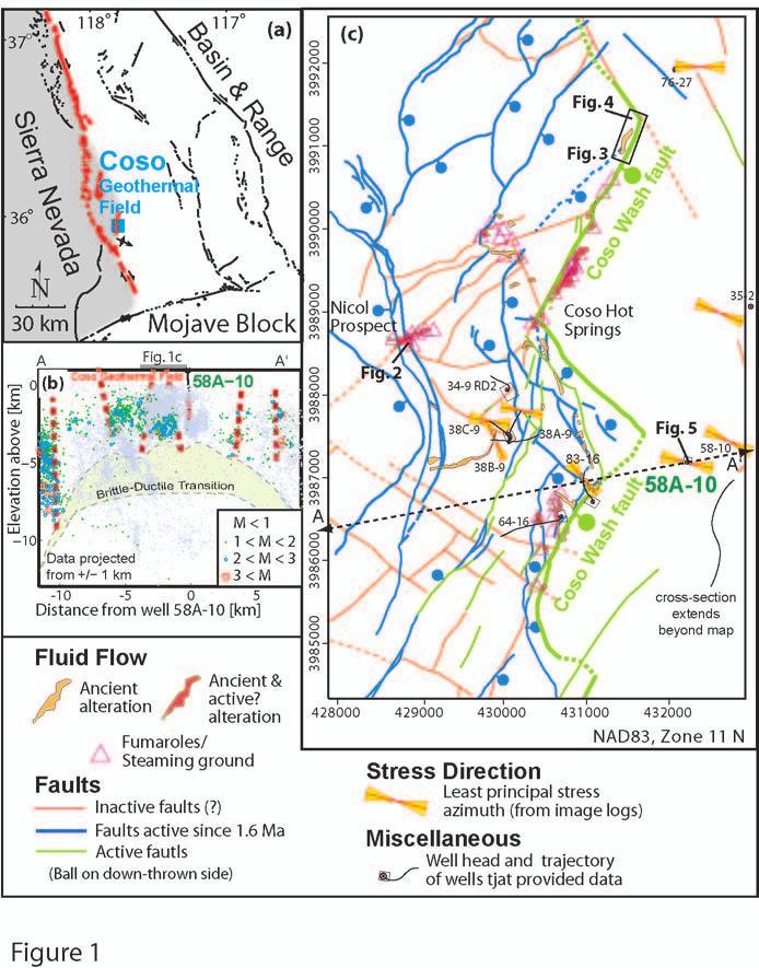
3 Geological Setting The Coso Geothermal Field is rooted in dominantly granitoid rocks overlain by rhyolites and basalts. It is located immediately east of the Sierra Nevada at the transition from dextral strike-slip tectonics, characteristic of the San Andreas Fault system, to east-west extension along Basin and Range style normal faults (Figure 1a ). A shallow silica-rich partial melt topping out at 4-5 km depth provides both the source for recently extruded volcanic materials and high modern heat flow (Unruh and Hauksson, 2003; Manley and Bacon, 2001). Alteration in the Coso Geothermal Field varies with temperature and depth (Lutz et al., 1996; Kovac et al., 2005) and defines a caprock of clay-dominated alteration. These clay-bearing intervals coincide with high geothermal gradients and are consistent with conductive heat transfer and low permeability situated above the exploited geothermal reservoir. Development of that geothermal reservoir has provided an electric power generating capacity in excess of 240 MW (Adams et al., 2000). Methods We use several lines of evidence to infer the mechanisms by which faults at Coso form and slip and how this, in turn, controls the permeability structure of the Coso Geothermal Field. Surface outcrops, core, and image logs constrain the geometry, mineralogy, and textures of the structures in fault zones. These data are used to infer the mechanisms of deformation and faultslip behavior (Davatzes et al., 2005). Modern and paleo-fluid flow within the geothermal field are inferred from the distribution of fluid flow at the surface, temperature profiles, mud loss during drilling, and the distribution of seismicity. Fluid flow data and deformation data are crosscorrelated to establish the relationship of fault zones to fluid flow. Fault zones structure and deformation mechanisms We have distinguished three distinct types of fault zones within the Coso Geothermal Field: (1) Fault zones containing intense alteration, resulting in disaggregation and subsequent replacement of most rock-forming minerals with kaolinite; (2) Fault zones associated with breccia, high fracture density, locally large fracture aperture, and fractures healed by the precipitation of calcite; and (3) Fault zones with a core dominated by chlorite and smectite fault rocks surrounded by highly fractured host rock and rare calcite veins. In the following sections, we describe these fault zones using representative examples (locations shown in Figure 1c), interpret the mechanisms of deformation, and explore their implications for the physical behavior and development of the fault zone. (1) Pervasively altered fault rocks rich in kaolinite and silica An example of an altered kaolinite-rich fault zone is exposed by excavation of the mercury mine at the Nicol Prospect (Figure 2a). The fault core (the part of the fault that accommodates most of the deformation and shear strain) is comprised of kaolinite-rich fault gouge (Figure 2a, b) and isolated breccia clasts. The gouge zone contains a through-going striated slip surface (Figure 2c) and subsidiary shorter slip surfaces. The through-going slip surfaces are coated by and incorporate microspheres of amorphous silica (Figure 2d). The major rock-forming minerals such as feldspar, hornblende, and biotite have been leached out of the breccia clasts, increasing the porosity, and are partly replaced with alteration phases such as kaolinite (Figure 2e). The core of the fault is surrounded by highly fractured rocks comprising a damage zone with minor mineralization and small slickensided faults exhibiting several 3
4 centimeters of down-dip (normal faulting) slip. Intense alteration is primarily confined to the fault core and becomes less intense with greater distance from the slip surface. This distribution of alteration is consistent with fluid flow primarily focused along the slip surface and bleeding out into the surrounding gouge and fractured damage zone. (2) Brecciated, dilatant, calcite rich fault zones Different fault zone mineralogy and structure are evident in the damage zone of the Coso Wash normal fault (Figure 3a) exposed NNE of the Coso Wash Hot Springs. At that location, the damage zone is comprised of a series of small faults and fractures that mirror the local orientation of the modern fault scarp. Many of these fractures contain fibrous veins more than 10 cm thick (Figure 3b) consistent with deposition into void space. Dilatant (tensile) fractures also occur in association with sheared fractures (Figure 3c). In general, the tensile fractures intersect the sheared fracture at an angle approximately between 50º and 75º and are asymmetrically distributed about it. This geometry and age relationship is consistent with the formation of splay fractures that propagate in response to tensile stresses concentrated at the tip or at asperities of a slipping shear fracture (Davatzes and Aydin, 2003). Splay fractures are densest in extensional steps between two overlapping, en echelon sheared fractures (Figure 3c) where they define fracture-bounded rhombs of rock. Shearing of fractures healed by precipitation (Figure 3d) is associated with the rotation of the fracture-bounded volumes and the formation of breccia, indicating that fracture porosity is regenerated following healing. (3) Chlorite-smectite rich fault zones The third fault zone type is distinguished by a fault core dominantly composed of chlorite and smectite (Figure 4a). Multiple, linking slip surfaces are distributed across the fault core and anastomoze around more intact blocks of the host rock (as shown in Figure 4b). Slip surfaces are polished and coated by chlorite and smectite. Within the shear zone the chlorite shows foliation subparallel to the fault strike and dip. Porosity is relatively low in the fault rock, and pores appear to be isolated. The textural relationship of the fault rock to the breccia blocks and margins of the fault core indicates relatively ductile deformation by folding of chlorite and smectite foliation and extrusion of clay into void space. Adjacent to the fault core, the country rock is highly fractured. Breccia and brittle fractures in the damage zone are well-connected and dense, but do not cross the fault core. Evidence for the fluid flow behavior of faults Fluid flow along faults in the Coso Geothermal Field is indicated by the preferred distribution of surface alteration, fumaroles, and steaming ground along faults and at some fault intersections (Figure 1c). The most predominant active surface flow is associated with NNE trending normal faults that are well oriented for slip in the modern stress state (Figure 1c) and show geomorphic evidence for slip, including offset alluvial fans. Subsurface fluid flow along faults is indicated by perturbations in borehole temperature logs (see discussion in Barton et al, 1998) and mud losses that coincide with faults visible in image logs (see example from well 58A-10 in Figure 5). In addition, near-isothermal temperature gradients, such as seen in well 58A-10 over the depth interval labeled zone 2 (Figure 5), indicate convective fluid flow that requires high permeability along a network of fractures. 4
5 It is more difficult to determine where faults act as barriers to fluid flow, although this can be inferred from borehole temperature logs in addition to the distribution of seismicity. The repeat temperature logs from well 58A-10 (Figure 5) distinguish two zones of high temperature gradient labeled zones 1 and 3. These high temperature gradients suggest conductive heat transfer and low permeability, despite fracture densities and orientations similar to zone 2, where convection dominates (Davatzes and Hickman, 2005). Another important aspect of zone 2 is the presence of very small but abrupt changes in geothermal gradient across faults (labeled as subzones A-E in Figure 5). These small-scale transitions in gradient are consistent with these faults acting as limited, or transient, barriers to fluid flow. In addition, locally high rates of seismicity within the actively produced Coso Geothermal Field and the spatial association of this seismicity with boreholes suggest that most micro-earthquakes are probably related to fluid pressure variations induced by fluid production or injection (Feng and Lees, 1998). However, sharply defined margins to this otherwise diffuse seismicity coincide with faults visible at the surface (Figure 1b). These sharply defined terminations of seismicity indicate that these faults act as barriers to fluid flow, limiting the spatial extent of fluid pressure variation and effectively compartmentalizing the Coso Geothermal Field. In most locations, faults display indications of both focused fluid flow and barrier behavior. One example is the fault seen at 6900 ft in well 58A-10 (Figure 5), which was associated with significant mud losses while drilling and persistent negative temperature gradients. This fault also separates adjacent sub-zones of distinct temperature gradient. Similarly, the Coso Wash normal fault system (Figure 1c) hosts fumaroles but also defines the margins of earthquake clusters (Figure 1b). In both cases fluid flow across the fault appears to be inhibited, whereas fluid flow along the fault is enhanced. Conceptual model of fluid flow and fault mechanics in the Coso Geothermal System The distribution of active fumaroles and steaming ground at the surface (Figure 1c) indicate that fluid flow is primarily associated with active fault segments trending NNE and at intersections between fault segments. However, not all of the faults (or fault segments) seen at Coso appear to be permeable. For example, the temperature profiles (Figure 5) and geologic well log from well 58A-10 suggest that the conductive zone of low fluid flow (zone 1) is associated with abundant clay mineralization, in contrast to the convecting zone (zone 2) which is associated with calcite precipitation and little alteration. Furthermore, the mineralogy and texture of the different fault zones identified at Coso (Figures 2, 3, and 4) indicate the role of different deformation mechanisms and structural/geochemical history. For example, faults healed by the precipitation of calcite and related minerals continue to undergo brittle dilation when reactivated and thus regenerate permeability (Figure 3). In contrast, the introduction of chlorite and other sheet silicates such as smectite appear to promote ductility and thereby minimize dilatancy of the fault rock during shear (Figure 4). In the following sections we discuss the relationship of the deformation mechanisms that control fluid flow to the deformation environments defined by the shallow 5
6 ground water system, clay-rich caprock, reservoir interval, and partial melt that define the Coso Geothermal System. This discussion is indexed to the four zones shown in Figure 6b. Zone 1. Shallow groundwater flow: In the shallowest zone, groundwater flow circulates through a network of diffusely distributed fractures associated with active faulting and dilatant failure facilitated by low confining stress. Rising geothermal fluids or boiling in areas of high heat flow and slow recharge exsolve gases that can mix with shallow groundwater, potentially lowering the ph and promoting mineral dissolution (Facca and Tonani, 1967). Dissolution of major rockforming minerals such as feldspar, plagioclase, hornblende, pyroxene and biotite should initially increase fault zone permeability. This overall gradual increase in permeability will be augmented by sudden permeability increases induced by dilatancy accompanying episodic fault slip (spikes in Figure 6d). Zone 2. Caprock: The caprock is characterized by conductive heat flow and minimal circulation of fluid. Initial fault formation and slip is the result of brittle-dilatant failure. However, continued slip and fluid flow leads to the formation of smectite phases and chlorite that inhibit dilation accompanying slip. Alteration is greatest in the fault core and decreases into the host rock. As a result, any damage outside the fault core in unaltered rock remains dilatant. Consequently, faultparallel permeability increases as cross-fault permeability decreases. The net result is the progressive development of faults with low cross-fault permeability and enhanced fault-parallel permeability. Although permeability might increase in the fault damage zones, the intersection of non-parallel (e.g., conjugate) fault cores truncates the damage zone, leading to a caprock with low overall permeability. Over the lifetime of the geothermal system, continued alteration should further isolate and reduce the size of zones of dilatant failure that generate fracture permeability. The vertical permeability seal provided by this clay-rich cap could be breached by the development of (1) new fault networks or (2) localized dilation related to fault geometry. New fault networks form when there is a sudden change in tectonic stress that is unfavorable for reactivation of an established fault network. Because alteration is primarily localized along the older fault networks, new faults will principally propagate through nearly unaltered rock that favors brittle failure. Owing to the low frictional strength of most clays (Lockner and Beeler, 2002), large rotations of the stress state are required to create new faults in a clay-rich cap, suggesting that breaching of the cap rock by new fault networks will be more difficult.;. Also, mechanical interaction of fault segments at extensional steps or intersections can locally produce more tensile mean stress that promotes dilatant failure (Davatzes et al., 2005). This mechanism could produce a pathway for fluids to migrate from reservoir depths to the surface along parts of faults essentially breaching the cap rock. Zone 3. Reservoir zone: The reservoir zone is dominated by brittle fracture, brecciation, and cataclasis. Healing primarily occurs by the precipitation of calcite or silica (potentially promoted by convection). In general, the near absence of clays and other phyllosilicates in the reservoir zone prevents the formation of a persistently low-permeability fault core. Thus, across-fault as well as along-fault permeability will be regenerated by periodic fault slip (Figure 6d). In detail, reduced grain size in the fault core due to cataclasis increases the area of fresh mineral surfaces and the rate of chemical reactions and precipitation on those surfaces. This suggests that the core of reservoir faults will heal faster than the damage zone during the inter-seismic period and thus 6
7 produce transient across-fault barriers or low-permeability zones (Byerlee, 1993). Consequently, convection can be temporarily confined within isolated damage zones resulting in small steps in temperature gradient (shown diagrammatically in Figure 6b), even though these transient seals will be periodically ruptured so that the permeability within the reservoir remains generally high. 4. Crystal-plastic deformation below the brittle-ductile transition: As temperature increases with depth and proximity to the heat source, crystal plastic deformation becomes the dominant means of accommodating strain. Large earthquakes can locally extend the depth of micro-seismicity (as indicated by the jagged top of the brittle-ductile transition in Figure 1b) by locally increasing the strain rate. However, the permeability of fault and country rock in this zone is expected to be quite low. Conclusions The feedback between fracture slip, the generation of permeability, fluid flow and alteration suggests that fracture permeability will evolve concurrently with the geothermal system. Initial fracture development in un-altered crystalline rocks will enhance permeability and allow the circulation of fluids, the transfer of heat, and initiate chemical alteration. Chemical alteration will eventually lead to the breakdown of rock forming minerals and alteration to clays within appropriate temperature and pressure conditions. The presence of clay in the cap rock mitigates the ability of fracture slip to generate permeability and consequently isolates a deeper geothermal reservoir from the surface. In contrast, in reservoir rocks permeability is maintained in fracture systems of calcite- or silica-dominated fracture sealing through dilatancy accompanying episodic slip despite exposure to the same stress state and deformation conditions as in the cap rock. Acknowledgments Much of the data analyzed was made available through the Navy Geothermal Program Office. John Solum and Joe Moore provided valuable feedback. Steve Bjornstad, Patrick Muffler and Colin Williams provided critical reviews of the science and text. David Blackwell reviewed the manuscript for the Geothermal Resources Council. Funding was provided by the U.S. Geological Survey Mendenhall Fellowship. References Adams, M.C., Moore, J.N., Bjornstad, S., and Norman, D.I Geologic history of the Coso Geothermal Field. Proceedings World Geothermal Congress 2000, Kyushu Tohoku, Japan, May 28 June 10, p Barton, C., Hickman, S., Morin, R., Zoback, M.D., and Benoit, R.,1998, Reservoir-scale fracture permeability in the Dixie Valley, Nevada, geothermal field, in Rock Mechanics in Petroleum Engineering, vol. 2, R. M. Holt et al. (eds.), Society of Petroleum Engineers, Richardson, TX., p Boitnott, G.N Core analysis for the development and constraint of physical models of geothermal reservoirs. Geothermal Research Council Transactions 26,
8 Brown, S.R Fluid flow through rock joints: Effects of surface roughness. J. Geophys. Res. 99, p Byerlee, J.D A model for episodic flow of high pressure water in fault zones before earthquakes. Geology, 21, p Crawford, B.R., Myers, R.D., Woronow, A., Faulkner, D.R., and Rutter, E.H Porositypermeability relationships in clay-bearing fault gouge. SPE/IRSM 78214, p Davatzes, N.C. and Hickman, S Comparison of acoustic and electrical image logs from the Coso Geothermal Field, CA. Proceedings, Thirtieth Workshop on Geothermal Reservoir Engineering, Stanford University, January 31- February 2, SGP-TR-176, p Davatzes, N.C. and Aydin, A The formation of conjugate normal fault systems in folded sandstone by sequential jointing and shearing, Waterpocket monocline, Utah. Journal of Geophysical Research 108(B10), p Davatzes, N.C., Eichhubl, P., and Aydin, A Structural evolution of fault zones in sandstone by multiple deformation mechanisms; Moab Fault, southeast Utah. Geological Society of America Bulletin, vol.117, no.1-2, p Facca, G. and Tonani, F The self-sealing geothermal field. Bulletin of Volcanology, 30, p Feng, Q. and Lees, J.M Microseismicity, stress, and fracture in the Coso geothermal field, California. Tectonophysics, 289, p Geomechanics International Fracture permeability and in situ stress in the eastern extension of the Coso Geothermal Reservoir; Kinematic and dynamic studies of the Coso Geothermal and surrounding area. Report prepared for the Navy Geothermal Program Office. Report number N R p. Hulen, J. B Geology and alteration of the Coso geothermal area, Inyo County, California. U. S. Department of Energy: Geothermal Energy. Kovac, K.M. Moore, J.N., and Lutz, S.J Geologic framework of the East Flank, Coso Geothermal Field: Implications for EGS development. Thirtieth Workshop on Geothermal Reservoir Engineering, Stanford University, Stanford, California, January 31-February 2, 2005, SGP-TR-176, 7 p. Lockner, D.A. and Beeler, N.M Rock failure and earthquakes. International Handbook of Earthquake and Engineering seismology, 81A, p Lutz, S.J., Moore, J.N., Copp, J.F Integrated mineralogical and fluid inclusion study of the Coso Geothermal System, California. Proceedings, 21st Workshop on Geothermal Reservoir Engineery, Stanford University, Stanford, California, p Manley, C.R. and Bacon, C.R Rhyolite thermobarometry and the shallowing of the magma reservoir, Coso Volcanic Field, California. J. Petrol. 41, p Moore, J., Norman, D., and Adams, M Thermal and chemical history of the Eastern Coso Geothermal Field. Report to the Navy Geothermal Program Office. Report N p. Sheridan, J. and Kovac, K.M., Rose, P. E., Barton, C. A., McCulloch, J., Berard, B., Moore, J. N., Petty, S. & Spielman, P In situ stress, fracture and fluid flow analysis-east Flank of the Coso Geothermal Field. Twenty-eighth Workshop on Geothermal Reservoir Engineering, Stanford University, Stanford, California, January 27-29, SGP-TR-173, 16 p. Unruh, J. R. and Hauksson, E Seismotectonics of an Evolving Intra-Continental Plate Boundary, East-Central California. Geothermal Program Office Technical Symposium 8, University of California, Davis, CA. 8
9 Whitmarsh, R.C Structural development of the Coso Range and adjacent areas of eastern California [Ph.D. thesis]: Lawrence, Kansas, University of Kansas. 9
10 Figure Captions Figure 1: (a) Location map of the Coso Geothermal Field. (b) Cross section of seismicity from 1993 to 2003 at the Coso Geothermal Field recorded by the local seismometer network operated by the Navy Geothermal Program Office. We infer that the brittle-ductile transition roughly coincides with the abrupt decrease in earthquake occurrence. (c) Tectonic map of the east flank of the Coso Geothermal field. Minimum horizontal stress orientations inferred from borehole image logs were compiled from Geomechanics International (2003), Sheridan et al. (2003), and Davatzes and Hickman (2005). Location of alteration, fumaroles, and steaming ground is based on new mapping and results from Hulen (1978) and Whitmarsh (1998). Figure 2: (a) Map of altered kaolinite-rich fault zone (location Figure 1c) distinguishing zones of different deformation and alteration intensity. Scanning Electron Microscope images of (b) foliated kaolinite-rich fault gouge, (c) striated fault slip surface, (d) microspheres and rod-like structures of amorphous silica, and (e) altered breccia clasts. Figure 3: (a) Geologic map of the Coso Wash fault scarp and zones of massive veins and breccia in granodiorite (location Figure 1c). Detailed photos of damage zone structures including: (b) layered carbonate vein, (c) dilatant fractures (splay fractures) localized between sheared fractures, (d) breccia and associated splay fractures. Figure 4: (a) Oblique photograph and sketch map of fault zone rich in chlorite (strike/dip = ~303/50º) (location Figure 1c). (b) Core from a depth of 679 ft with similar structures from well Figure 5: Repeat temperature profiles measured in well 58A-10 located in Coso Wash (location Figure 1c), mud losses while drilling (spikes), stress rotations (Davatzes and Hickman, 2005), and unwrapped borehole televiewer image and caliper log of fault zone at 6900 ft measured depth. Figure 6: Conceptual model of fluid flow along faults in a geothermal system. The approximate distribution of alteration clay phases follows the work of Lutz et al., (1996), Moore et al. (2004), and Kovac et al. (2005). 10
11

12

13

14

15

16
Reservoir Geomechanics and Faults
 Reservoir Geomechanics and Faults Dr David McNamara National University of Ireland, Galway david.d.mcnamara@nuigalway.ie @mcnamadd What is a Geological Structure? Geological structures include fractures
IN SITU STRESS, FRACTURE AND FLUID FLOW ANALYSIS EAST FLANK OF THE COSO GEOTHERMAL FIELD
 PROCEEDINGS, Twenty-Eighth Workshop on Geothermal Reservoir Engineering Stanford University, Stanford, California, January 27-29, 2003 SGP-TR-173 IN SITU STRESS, FRACTURE AND FLUID FLOW ANALYSIS EAST FLANK
Using Fluid Inclusion Stratigraphy Analyses to Distinguish Producing Wells from Nonproducing Wells in the Coso Geothermal Field, California
 Proceedings World Geothermal Congress 25 Antalya, Turkey, 24-29 April 25 Using Fluid Inclusion Stratigraphy Analyses to Distinguish Producing Wells from Nonproducing Wells in the Coso Geothermal Field,
An Enhanced Geothermal System at Coso, California Recent Accomplishments
 Proceedings World Geothermal Congress 2005 Antalya, Turkey, 24-29 April 2005 An Enhanced Geothermal System at Coso, California Recent Accomplishments Peter Rose 1, Judith Sheridan, Jess McCulloch, Joseph
COMPARISON OF ACOUSTIC AND ELECTRICAL IMAGE LOGS FROM THE COSO GEOTHERMAL FIELD, CA
 PROCEEDINGS, Thirtieth Workshop on Geothermal Reservoir Engineering Stanford University, Stanford, California, January 31-February 2, 2005 SGP-TR-176 COMPARISON OF ACOUSTIC AND ELECTRICAL IMAGE LOGS FROM
WAMUNYU EDWARD MUREITHI I13/2358/2007
 WAMUNYU EDWARD MUREITHI I13/2358/2007 Olkaria geothermal area is situated south of Lake Naivasha on the floor of the southern segment of the Kenya rift. The geology of the Olkaria Geothermal area is subdivided
FLUID STRATIGRAPHY OF THE COSO GEOTHERMAL RESERVOIR
 PROCEEDINGS, Thirty-First Workshop on Geothermal Reservoir Engineering Stanford University, Stanford, California, January 30-February 1, 2006 SGP-TR-179 FLUID STRATIGRAPHY OF THE COSO GEOTHERMAL RESERVOIR
The Coso Geothermal Area: A Laboratory for Advanced MEQ Studies for Geothermal Monitoring
 The Coso Geothermal Area: A Laboratory for Advanced MEQ Studies for Geothermal Monitoring Bruce R. Julian U. S. Geological Survey, Menlo Park, CA 94025 USA julian@usgs.gov Gillian R. Foulger Dept. Earth
EVALUATING HEAT FLOW AS A TOOL FOR ASSESSING GEOTHERMAL RESOURCES
 PROCEEDINGS, Thirtieth Workshop on Geothermal Reservoir Engineering Stanford University, Stanford, California, January 31-February 2, 2005 SGP-TR-176 EVALUATING HEAT FLOW AS A TOOL FOR ASSESSING GEOTHERMAL
NOTICE CONCERNING COPYRIGHT RESTRICTIONS
 NOTICE CONCERNING COPYRIGHT RESTRICTIONS This document may contain copyrighted materials. These materials have been made available for use in research, teaching, and private study, but may not be used
Fault Rocks. EARS5136 slide 1
 Fault Rocks EARS5136 slide 1 Fault rocks Fault rock types Examples of deformation features in cores Microstructures Porosity and permeability Lithological and lithification control EARS5136 slide 2 Deformation
What Causes Rock to Deform?
 Crustal Deformation Earth, Chapter 10 Chapter 10 Crustal Deformation What Causes Rock to Deform? Deformation is a general term that refers to all changes in the shape or position of a rock body in response
THE HETEROGENEOUS STRUCTURE OF FAULT ZONES WITHIN CARBONATE ROCKS: EVIDENCE FROM OUTCROP STUDIES AND IMPLICATIONS FOR FLUID FLOW
 THE HETEROGENEOUS STRUCTURE OF FAULT ZONES WITHIN CARBONATE ROCKS: EVIDENCE FROM OUTCROP STUDIES AND IMPLICATIONS FOR FLUID FLOW C.G. Bonson*, J.J. Walsh, C. Childs, M.P.J. Schöpfer & V. Carboni Fault
Characterization of Subsurface Permeability of the Olkaria East Geothermal Field
 PROCEEDINGS, 44th Workshop on Geothermal Reservoir Engineering Stanford University, Stanford, California, February 11-13, 2019 SGP-TR-214 Characterization of Subsurface Permeability of the Olkaria East
Estimation of fracture porosity and permeability using radon as a tracer
 PROCEEDINGS, 44th Workshop on Geothermal Reservoir Engineering Stanford University, Stanford, California, February 11-13, 2019 SGP-TR-214 Estimation of fracture porosity and permeability using radon as
Geothermal Systems: Geologic Origins of a Vast Energy Resource
 Geothermal Systems: Geologic Origins of a Vast Energy Resource Energy From the Earth Energy-Land-Water Connections Speaker Series James E. Faulds, PhD Nevada State Geologist and Professor Nevada Bureau
Crustal Deformation Earth - Chapter Pearson Education, Inc.
 Crustal Deformation Earth - Chapter 10 Structural Geology Structural geologists study the architecture and processes responsible for deformation of Earth s crust. A working knowledge of rock structures
SUB-SURFACE GEOLOGY AND HYDROTHERMAL ALTERATION OF WELLS LA-9D AND LA-10D OF ALUTO LANGANO GEOTHERMAL FIELD, ETHIOPIA
 Proceedings, 6 th African Rift Geothermal Conference Addis Ababa, Ethiopia, 2 nd -4 th November 2016 SUB-SURFACE GEOLOGY AND HYDROTHERMAL ALTERATION OF WELLS LA-9D AND LA-10D OF ALUTO LANGANO GEOTHERMAL
Geology 3120: Fault Rocks. Brittle shear zone, CO Natl Mon
 Geology 3120: Fault Rocks Brittle shear zone, CO Natl Mon Outline Fault rocks and strength Fault zone processes Fault rocks Example from Death Valley Fault Rocks and Strength Brittle Fault Zone Processes
Brittle Deformation. Earth Structure (2 nd Edition), 2004 W.W. Norton & Co, New York Slide show by Ben van der Pluijm
, 2004 W.W. Norton & Co, New York Slide show by Ben van der Pluijm") Lecture 6 Brittle Deformation Earth Structure (2 nd Edition), 2004 W.W. Norton & Co, New York Slide show by Ben van der Pluijm WW Norton, unless noted otherwise Brittle deformation EarthStructure (2 nd
Lecture 6 Brittle Deformation Earth Structure (2 nd Edition), 2004 W.W. Norton & Co, New York Slide show by Ben van der Pluijm WW Norton, unless noted otherwise Brittle deformation EarthStructure (2 nd
STRESS AND FAULTING IN THE COSO GEOTHERMAL FIELD: UPDATE AND RECENT RESULTS FROM THE EAST FLANK AND COSO WASH
 PROCEEDINGS, Thirty-First Workshop on Geothermal Reservoir Engineering Stanford University, Stanford, California, January 30-February 1, 2006 SGP-TR-179 STRESS AND FAULTING IN THE COSO GEOTHERMAL FIELD:
Ann Moulding and Tom Brikowski University of Texas at Dallas, Department of Geosciences
 GRC Transactions, Vol. 39, 2015 Influence of Continuously Variable Permeability and Basin Rock Properties on Three Dimensional Heat and Mass Balance Models of Basin & Range Geothermal Systems Ann Moulding
CHAPTER 3.3: METAMORPHIC ROCKS
 CHAPTER 3.3: METAMORPHIC ROCKS Introduction Metamorphism - the process of changes in texture and mineralogy of pre-existing rock due to changes in temperature and/or pressure. Metamorphic means change
Earthquakes. Earthquakes are caused by a sudden release of energy
 Earthquakes Earthquakes are caused by a sudden release of energy The amount of energy released determines the magnitude of the earthquake Seismic waves carry the energy away from its origin Fig. 18.1 Origin
Chapter 7 Metamorphism, Metamorphic Rocks, and Hydrothermal Rocks
 Chapter 7 Metamorphism, Metamorphic Rocks, and Hydrothermal Rocks Copyright The McGraw-Hill Companies, Inc. Permission required for reproduction or display. Metamorphism What happens to rocks that are
Exploration of Geothermal High Enthalpy Resources using Magnetotellurics an Example from Chile
 Exploration of Geothermal High Enthalpy Resources using Magnetotellurics an Example from Chile Ulrich Kalberkamp, Federal Institute for Geosciences and Natural Resources (BGR), Stilleweg 2, 30655 Hannover,
Coupling between deformation and fluid flow: impacts on ore genesis in fracture-controlled hydrothermal systems
 Coupling between deformation and fluid flow: impacts on ore genesis in fracture-controlled hydrothermal systems Stephen F Cox Research School of Earth Sciences The Australian National University INTRODUCTION
Role of lithological layering on spatial variation of natural and induced fractures in hydraulic fracture stimulation
 Role of lithological layering on spatial variation of natural and induced fractures in hydraulic fracture stimulation Vincent Roche *, Department of Physics, University of Alberta, Edmonton roche@ualberta.ca
Modeling pressure response into a fractured zone of Precambrian basement to understand deep induced-earthquake hypocenters from shallow injection
 Modeling pressure response into a fractured zone of Precambrian basement to understand deep induced-earthquake hypocenters from shallow injection S. Raziperchikolaee 1 and J. F. Miller 1 Abstract Analysis
5 IEAGHG CCS Summer School. Geological storage of carbon dioxide (a simple solution)
") Storage 1- Reservoirs, Traps, Seals and Storage Capacity for Storage Geological storage of carbon dioxide (a simple solution) Professor John Kaldi Chief Scientist, CO2CRC Australian School of Petroleum,
Storage 1- Reservoirs, Traps, Seals and Storage Capacity for Storage Geological storage of carbon dioxide (a simple solution) Professor John Kaldi Chief Scientist, CO2CRC Australian School of Petroleum,
Characterizing Seal Bypass Systems at the Rock Springs Uplift, Southwest Wyoming, Using Seismic Attribute Analysis*
 Characterizing Seal Bypass Systems at the Rock Springs Uplift, Southwest Wyoming, Using Seismic Attribute Analysis* Yuri Ganshin 1 and Fred McLaughlin 1 Search and Discovery Article #80483 (2015)** Posted
Distinguished Lecturer David A. Ferrill. Sponsored by AAPG Foundation
 Distinguished Lecturer David A. Ferrill Sponsored by AAPG Foundation AAPG Membership Information Benefits: Monthly Receipt of AAPG Explorer & AAPG Bulletin Discounts on Books and Other Publications Registration
Multiscale Seismic Signature of a Small Fault Zone in a Carbonate Reservoir: Relationships Between V P Imaging, Fault Zone Architecture and Cohesion*
 Multiscale Seismic Signature of a Small Fault Zone in a Carbonate Reservoir: Relationships Between V P Imaging, Fault Zone Architecture and Cohesion* Pierre Jeanne 1,2, Yves Guglielmi 2, and Frédéric Cappa
Deformation of Rocks. Orientation of Deformed Rocks
 Deformation of Rocks Folds and faults are geologic structures caused by deformation. Structural geology is the study of the deformation of rocks and its effects. Fig. 7.1 Orientation of Deformed Rocks
Evaluation of Structural Geology of Jabal Omar
 International Journal of Engineering Research and Development e-issn: 2278-067X, p-issn: 2278-800X, www.ijerd.com Volume 11, Issue 01 (January 2015), PP.67-72 Dafalla Siddig Dafalla * and Ibrahim Abdel
material would flow extremely slowly similarly to a brittle material. The shear zone
 GSA DATA REPOSITORY 21468 Hayman and Lavier Supplementary model description: Lavier et al. (213) showed that formation or reactivation of mixed mode fractures in ductile shear zones might generate variations
R.Suhasini., Assistant Professor Page 1
 UNIT I PHYSICAL GEOLOGY Geology in civil engineering branches of geology structure of earth and its composition weathering of rocks scale of weathering soils - landforms and processes associated with river,
Faults. Strike-slip fault. Normal fault. Thrust fault
 Faults Strike-slip fault Normal fault Thrust fault Fault any surface or narrow zone with visible shear displacement along the zone Normal fault Strike-slip fault Reverse fault Thrust fault
Chapter 21: Metamorphism. Fresh basalt and weathered basalt
 Chapter 21: Metamorphism Fresh basalt and weathered basalt Chapter 21: Metamorphism The IUGS-SCMR proposed this definition: Metamorphism is a subsolidus process leading to changes in mineralogy and/or
Geology 229 Engineering Geology. Lecture 7. Rocks and Concrete as Engineering Material (West, Ch. 6)
") Geology 229 Engineering Geology Lecture 7 Rocks and Concrete as Engineering Material (West, Ch. 6) Outline of this Lecture 1. Rock mass properties Weakness planes control rock mass strength; Rock textures;
Geology 229 Engineering Geology Lecture 7 Rocks and Concrete as Engineering Material (West, Ch. 6) Outline of this Lecture 1. Rock mass properties Weakness planes control rock mass strength; Rock textures;
KEY FEATURES OF OPAL VEIN DEPOSITS AT LIGHTNING RIDGE, NSW, AUSTRALIA
 KEY FEATURES OF OPAL VEIN DEPOSITS AT LIGHTNING RIDGE, NSW, AUSTRALIA Dr. Simon R. Pecover Pan Gem Resources (Aust) Pty Ltd Photo by Sarah Pecover Distribution of Opal Deposits in the Great Australian
Hydrothermal Systems as Analogs for Breached hdtraps and Subsurface Healing: Outcrop and Subsurface Examples and Escape Mechanisms
 Hydrothermal Systems as Analogs for Breached hdtraps and Subsurface Healing: Outcrop and Subsurface Examples and Escape Mechanisms David Bowen, David Lageson, Lee Spangler (Montana State University) Bryan
FRACTURE PERMEABILITY AND ITS RELATIONSHIP TO IN-SITU STRESS IN THE DIXIE VALLEY, NEVADA, GEOTHERMAL RESERVOIR
 il ~-- ~ PROCEEDINGS. Twenty-Second Workshop on Geothermal Reservoir Engineenng Stanford Unlverslty, Stanford. California, January 27-29, 1997 SGP-TR- 155 FRACTURE PERMEABILITY AND ITS RELATIONSHIP TO
Lecture 7. Joints and Veins. Earth Structure (2 nd Edition), 2004 W.W. Norton & Co, New York Slide show by Ben van der Pluijm
, 2004 W.W. Norton & Co, New York Slide show by Ben van der Pluijm") Lecture 7 Joints and Veins Earth Structure (2 nd Edition), 2004 W.W. Norton & Co, New York Slide show by Ben van der Pluijm WW Norton; unless noted otherwise Joints Three sets of systematic joints controlling
Lecture 7 Joints and Veins Earth Structure (2 nd Edition), 2004 W.W. Norton & Co, New York Slide show by Ben van der Pluijm WW Norton; unless noted otherwise Joints Three sets of systematic joints controlling
TECTONIC AND STRUCTURAL CONTROLS ON INTRUSION- RELATED DEPOSITS IN THE NORTHERN PART OF SREDNA GORA ZONE, BULGARIA NIKOLAY PETROV & KAMELIA NEDKOVA
 TECTONIC AND STRUCTURAL CONTROLS ON INTRUSION- RELATED DEPOSITS IN THE NORTHERN PART OF SREDNA GORA ZONE, BULGARIA NIKOLAY PETROV & KAMELIA NEDKOVA INVESTIGATED AREA Praveshka Lakavica deposit Elatsite
Targeting of Potential Geothermal Resources in the Great Basin from Regional Relationships between Geodetic Strain and Geological Structures
 Targeting of Potential Geothermal Resources in the Great Basin from Regional Relationships between Geodetic Strain and Geological Structures Geoffrey Blewitt and Mark Coolbaugh Great Basin Center for Geothermal
Composition of the earth, Geologic Time, and Plate Tectonics
 Composition of the earth, Geologic Time, and Plate Tectonics Layers of the earth Chemical vs. Mechanical Chemical : Mechanical: 1) Core: Ni and Fe 2) Mantle: Mostly Peridotite 3) Crust: Many different
1 Introduction. 1.1 Aims. 1.2 Rock fractures
 1 Introduction 1.1 Aims Rock fractures occur in a variety of geological processes and range in size from plate boundaries at the scale of hundreds of kilometres to microcracks in crystals at the scale
From Punchbowl to Panum: Long Valley Volcanism and the Mono-Inyo Crater Chain
 From Punchbowl to Panum: Leslie Schaffer E105 2002 Final Paper Long Valley Volcanism and the Mono-Inyo Crater Chain Figure 1. After a sequence of earthquakes during the late 1970 s to the early 1980 s
Kinematic inversion of pre-existing faults by wastewater injection-related induced seismicity: the Val d Agri oil field case study (Italy)
") Kinematic inversion of pre-existing faults by wastewater injection-related induced seismicity: the Val d Agri oil field case study (Italy) Buttinelli M., Improta L., Bagh S., Chiarabba C. 1/10 The Val
Kinematic inversion of pre-existing faults by wastewater injection-related induced seismicity: the Val d Agri oil field case study (Italy) Buttinelli M., Improta L., Bagh S., Chiarabba C. 1/10 The Val
The Frictional Regime
 The Frictional Regime Processes in Structural Geology & Tectonics Ben van der Pluijm WW Norton+Authors, unless noted otherwise 1/25/2016 10:08 AM We Discuss The Frictional Regime Processes of Brittle Deformation
Topics. Magma Ascent and Emplacement. Magma Generation. Magma Rise. Energy Sources. Instabilities. How does magma ascend? How do dikes form?
 Magma Ascent and Emplacement Reading: Encyclopedia of Volcanoes: Physical Properties of Magmas (pp. 171-190) Magma Chambers (pp. 191-206) Plumbing Systems (pp. 219-236) Magma ascent at shallow levels (pp.237-249)
Wind Mountain Project Summary Memo Feeder Program
 A Manex Resource Group Company Wind Mountain Project Summary Memo Feeder Program J.A. Kizis, Jr., February 07, 2018 Assays have been received for both holes drilled at Wind Mountain during late 2017 and
COMPOSITION and PHYSICAL PROPERTIES GENERAL SUBJECTS. GEODESY and GRAVITY
 COMPOSITION and PHYSICAL PROPERTIES Composition and structure of the continental crust Composition and structure of the core Composition and structure of the mantle Composition and structure of the oceanic
Apparent and True Dip
 Apparent and True Dip Cross-bedded building stone. The contact immediately below A appears to dip gently to the right, but at B, the contact appears to dip to the left. But it's not a syncline! Both of
Metamorphism and Metamorphic Rocks Earth - Chapter Pearson Education, Inc.
 Metamorphism and Metamorphic Rocks Earth - Chapter 8 Metamorphism Transition of one rock into another by temperatures and/or pressures unlike those in which it formed Metamorphic rocks are produced from:
Structural Geology tectonics, volcanology and geothermal activity. Kristján Saemundsson ÍSOR Iceland GeoSurvey
 Structural Geology tectonics, volcanology and geothermal activity Kristján Saemundsson ÍSOR Iceland GeoSurvey Discussion will be limited to rift zone geothermal systems with sidelook on hot spot environment.
The geology of the Vermont Valley and the western flank of the Green Mountains between Dorset Mountain and Wallingford, Vermont
 University at Albany, State University of New York Scholars Archive Geology Theses and Dissertations Atmospheric and Environmental Sciences 1992 The geology of the Vermont Valley and the western flank
A Closer Look At Hydrothermal Alteration and Fluid-Rock Interaction Using Scanning Electron Microscopy
 Proceedings World Geothermal Congress 2015 Melbourne, Australia, 19-25 April 2015 A Closer Look At Hydrothermal Alteration and Fluid-Rock Interaction Using Scanning Electron Microscopy Bridget Y. Lynne
An unusual 'crack--seal' vein geometry
 Journal of Structural Geology, Vol. 6, No. 5, pp. 593 to 597, 1984 0191--8141/84 $3.00 + 0.00 Printed in Great Britain Pergamon Press Ltd. An unusual 'crack--seal' vein geometry BEN A. VAN DER PLUJM Department
Deformation: Modification of Rocks by Folding and Fracturing
 CHAPTER 7 Deformation: Modification of Rocks by Folding and Fracturing Chapter Summary A geologic map is a scientific model of rock formations that are exposed on the Earth s surface showing outcrops,
TEMPERATURE GEOTHERMAL SYSTEM *.BY. Roger F. Harrison Salt Lake City, Utah. C; K. Blair
 - * f c * -6 9 -.I. lcal '. DEVELOPMENT AND TESTSNG OF A SMALL MODERATE TEMPERATURE GEOTHERMAL SYSTEM *.BY Roger F. Harrison Terra Tek, Inc. Salt Lake City, Utah C; K. Blair Terra Tek, Inc. - Salt Lake
Answers: Internal Processes and Structures (Isostasy)
") Answers: Internal Processes and Structures (Isostasy) 1. Analyse the adjustment of the crust to changes in loads associated with volcanism, mountain building, erosion, and glaciation by using the concept
Answers: Internal Processes and Structures (Isostasy) 1. Analyse the adjustment of the crust to changes in loads associated with volcanism, mountain building, erosion, and glaciation by using the concept
Fault Architecture, Associated Structures and Uranium Mineralization, Eastern Athabasca Basin: A Provisional Empirical Classification
 December 2014 Fault Architecture, Associated Structures and Uranium Mineralization, Eastern Athabasca Basin: A Provisional Empirical Classification David Thomas, Alex Aubin, Dan Brisbin, Joshua Mukwakwami,
RESERVOIR-SCALE FRACTURE PERMEABILITY IN THE DIXIE VALLEY, NEVADA, GEOTHERMAL FIELD
 PROCEEDINGS,Twenty-Third Workshop on Geothermal Reservoir Engineering Stanford University, Stanford, California. January 26-28.1998 SGP-TR- I58 RESERVOIR-SCALE FRACTURE PERMEABILITY IN THE DIXIE VALLEY,
IDENTIFYING FRACTURES USING FLUID INCLUSION STRATIGRAPHY: INSIGHTS FROM FLUID INCLUSION THERMOMETRY
 PROCEEDINGS, Thirty-Third Workshop on Geothermal Reservoir Engineering Stanford University, Stanford, California, January 28-30, 2008 SGP-TR-185 IDENTIFYING FRACTURES USING FLUID INCLUSION STRATIGRAPHY:
The Geology of Two Lights State Park. Cape Elizabeth, Maine
 Maine Geologic Facts and Localities June, 2002 Cape Elizabeth, Maine 43 33 33.48 N, 70 12 13.32 W Text by Henry N. Berry IV and Robert G. Marvinney, Department of Agriculture, Conservation & Forestry 1
NOA ASSESSMENT HARRIS QUARRY MENDOCINO COUNTY, CALIFORNIA TABLE OF CONTENTS
 NOA ASSESSMENT HARRIS QUARRY MENDOCINO COUNTY, CALIFORNIA TABLE OF CONTENTS Introduction... 1 Scope of Services... 1 Project Location and Description... 1 Geologic Setting... 1 Regional Geology... 1 Site
Name Class Date. In your textbook, read about the nature of igneous rocks. Use each of the terms below just once to complete the following statements.
 CHAPTER 5 Igneous Rocks SECTION 5.1 What are igneous rocks? In your textbook, read about the nature of igneous rocks. Use each of the terms below just once to complete the following statements. basaltic
Big Island Field Trip
 Big Island Field Trip Space Still Available Group Airline Tickets May be available if enough people sign on If interested send email to Greg Ravizza Planning Meeting Next Week Will
OVERVIEW OF THE WAIRAKEI-TAUHARA SUBSIDENCE INVESTIGATION PROGRAM
 PROCEEDINGS, Thirty-Sixth Workshop on Geothermal Reservoir Engineering Stanford University, Stanford, California, January 31 - February 2, 2011 SGP-TR-191 OVERVIEW OF THE WAIRAKEI-TAUHARA SUBSIDENCE INVESTIGATION
Seismic techniques for imaging fractures, cracks and faults in the Earth. Michael Kendall
 Seismic techniques for imaging fractures, cracks and faults in the Earth Michael Kendall Issues and Challanges Geometry (aspect ratio, size, orientation, density) Non-uniqueness (e.g., single set of aligned
Engineering Geology ECIV 3302
 Engineering Geology ECIV 3302 Instructor : Dr. Jehad Hamad 2019-2018 Chapter (7) Metamorphic Rocks Chapter 7 Metamorphism and Metamorphic Rocks Metamorphism The transition of one rock into another by temperatures
Summary of Rover Metals Geologic Mapping Program at the Up Town Gold Project, Northwest Territories
 October 13, 2017 Summary of Rover Metals Geologic Mapping Program at the Up Town Gold Project, Northwest Territories Vancouver, British Columbia, Canada - Rover Metals Corp., Rover, is pleased to provide
DETAILED IMAGE OF FRACTURES ACTIVATED BY A FLUID INJECTION IN A PRODUCING INDONESIAN GEOTHERMAL FIELD
 PROCEEDINGS, Thirty-Fourth Workshop on Geothermal Reservoir Engineering Stanford University, Stanford, California, February 9-11, 2009 SGP-TR-187 DETAILED IMAGE OF FRACTURES ACTIVATED BY A FLUID INJECTION
 1-6 Figure 1.3. View of the field area, looking south-southwest. Left side of the picture shows the steep flank of the Green Mountain massif. The Vermont Valley and the Tinmouth Valley are separated by
The geomechanical significance of clay in geothermal reservoirs
 The geomechanical significance of clay in geothermal reservoirs Carola Meller, Emmanuel Gaucher, Thomas Kohl KIT Institute of Applied Geosciences, Div. Geothermal Research, Adenauerring 20b, 76131 Karlsruhe,
4D stress sensitivity of dry rock frame moduli: constraints from geomechanical integration
 Title 4D stress sensitivity of dry rock frame moduli: constraints from geomechanical integration Authors Bloomer, D., Ikon Science Asia Pacific Reynolds, S., Ikon Science Asia Pacific Pavlova, M., Origin
Stress Damage in Borehole and Rock Cores; Developing New Tools to Update the Stress Map of Alberta
 Stress Damage in Borehole and Rock Cores; Developing New Tools to Update the Stress Map of Alberta Qing Jia, University of Alberta, Edmonton qjia@ualberta.ca and Randy Kofman, University of Alberta, Edmonton
Chapter 15 Structures
 Chapter 15 Structures Plummer/McGeary/Carlson (c) The McGraw-Hill Companies, Inc. TECTONIC FORCES AT WORK Stress & Strain Stress Strain Compressive stress Shortening strain Tensional stress stretching
J.V. Herwanger* (Ikon Science), A. Bottrill (Ikon Science) & P. Popov (Ikon Science)
, A. Bottrill (Ikon Science) & P. Popov (Ikon Science)") 29829. One 4D geomechanical model and its many applications J.V. Herwanger* (Ikon Science), A. Bottrill (Ikon Science) & P. Popov (Ikon Science) Main objectives (i) Field case study demonstrating application
29829. One 4D geomechanical model and its many applications J.V. Herwanger* (Ikon Science), A. Bottrill (Ikon Science) & P. Popov (Ikon Science) Main objectives (i) Field case study demonstrating application
Drill locations for the 2015 program are highlighted in the geology map below.
 2015 Exploration Program The exploration program plan at KSM for 2015 was designed to improve the understanding of block cave targets and support engineering/environmental aspects of development scenarios.
Seismic Reflection Imaging across the Johnson Ranch, Valley County, Idaho
 Seismic Reflection Imaging across the Johnson Ranch, Valley County, Idaho Report Prepared for the Skyline Corporation Lee M. Liberty Center for Geophysical Investigation of the Shallow Subsurface (CGISS)
EARTH SCIENCE. Geology, the Environment and the Universe. Chapter 5: Igneous Rocks
 EARTH SCIENCE Geology, the Environment and the Universe Chapter 5: Igneous Rocks CHAPTER 5 Igneous Rocks Section 5.1 What are igneous rocks? Section 5.2 Classification of Igneous Rocks Click a hyperlink
Instituto De Ingenieros De Minas Del Peru
 The Continuity Challenge Dr. Wayne Barnett The Interpretation! Great geological continuity? Huge potential? The Reality Not what it might seem... Not what it might seem... Presentation Objective Highlight
GeothermEx, Inc. GEOTHERMAL RESERVOIR ASSESSMENT METHODOLOGY FOR THE SCIENTIFIC OBSERVATION HOLE PROGRAM, KILAUEA EAST RIFT ZONE, HAWAII TASK 1 REPORT
 (415) 527 9876 CABLE ADDRESS- GEOTHERMEX TELEX 709152 STEAM UD FAX (415) 527-8164 Geotherm Ex, Inc. RICHMOND. CALIFORNIA 94804-5829 GEOTHERMAL RESERVOIR ASSESSMENT METHODOLOGY FOR THE SCIENTIFIC OBSERVATION
Crags, Cracks, and Crumples: Crustal Deformation and Mountain Building
 Crags, Cracks, and Crumples: Crustal Deformation and Mountain Building Updated by: Rick Oches, Professor of Geology & Environmental Sciences Bentley University Waltham, Massachusetts Based on slides prepared
Geologic Considerations of Shallow SAGD Caprock; Seal Capacity, Seal Geometry and Seal Integrity, Athabasca Oilsands, Alberta Canada
 Geologic Considerations of Shallow SAGD Caprock; Seal Capacity, Seal Geometry and Seal Integrity, Athabasca Oilsands, Alberta Canada Gordon T. Stabb, Michael Webb Durando Resources Corp, Suncor Energy
Structural deformation across the southwest Mina deflection, California-Nevada: Field studies in the Huntoon Springs area.
 Structural deformation across the southwest Mina deflection, California-Nevada: Field studies in the Huntoon Springs area. Eliya R. Hogan Advisor: Jeff Lee Introduction and purpose of study: The Mina deflection
Suzanne Picazo, Mathilde Cannat, Adelie Delacour, Javier Escartın, Stephane Roumejon, and Serguei Silantyev
 Correction Volume 14, Number 8 16 August 2013 doi: ISSN: 1525-2027 Correction to Deformation associated with the denudation of mantle-derived rocks at the Mid- Atlantic Ridge 13 15 N: The role of magmatic
Observations on a Veined Section of Core Drilled at Blockhouse, Lunenburg County
 Report of Activities 2016-17 53 Observations on a Veined Section of Core Drilled at Blockhouse, Lunenburg County R. F. Mills and A. MacKay 1 The Blockhouse gold district (NTS 21A/08) lies approximately
GY 111 Lecture Notes Intro to Metamorphism
 GY 111 Lecture Notes D. Haywick (2008-09) 1 Lecture Goals: A) Agents of Metamorphism B) Types of metamorphism C) Hydrothermal fluids GY 111 Lecture Notes Intro to Metamorphism Reference: Press et al.,
Practice Test Rocks and Minerals. Name. Page 1
 Name Practice Test Rocks and Minerals 1. Which rock would be the best source of the mineral garnet? A) basalt B) limestone C) schist D) slate 2. Which mineral is mined for its iron content? A) hematite
Extending the magnitude range of seismic reservoir monitoring by Utilizing Hybrid Surface Downhole Seismic Networks
 Extending the magnitude range of seismic reservoir monitoring by Utilizing Hybrid Surface Downhole Seismic Networks Gisela Viegas*, ESG, Kingston, Ontario, Canada Gisela.Fernandes@esgsolutions.com and
Figure 1: Location of principal shallow conductors at Alpala (anomalies C0-C10; 5 Ohm/m surfaces, red) and shallow zones of electrical chargeability
 and shallow zones of electrical chargeability") Figure 1: Location of principal shallow conductors at Alpala (anomalies C0-C10; 5 Ohm/m surfaces, red) and shallow zones of electrical chargeability (85 msecs, yellow-green) shown on iso-surfaces of MVI
Figure 1: Location of principal shallow conductors at Alpala (anomalies C0-C10; 5 Ohm/m surfaces, red) and shallow zones of electrical chargeability (85 msecs, yellow-green) shown on iso-surfaces of MVI
12. MYRMEKITE IN THE SANTA ROSA MYLONITE ZONE, PALM SPRINGS, CALIFORNIA
 1 ISSN 1526-5757 12. MYRMEKITE IN THE SANTA ROSA MYLONITE ZONE, PALM SPRINGS, CALIFORNIA Lorence G. Collins email: lorencec@sysmatrix.net February 15, 1997 Introduction Myrmekite, containing tiny quartz
Abstracts ESG Solutions
 Abstracts ESG Solutions 2015-2016 For more information, please contact Melissa Hoy, Technical Marketing Coordinator at melissa.hoy@esgsolutions.com Visit us online at www.esgsolutions.com Abstract #1 Fracture
Chapter 8 Lecture. Earth: An Introduction to Physical Geology. Twelfth Edition. Metamorphism. Rocks. Tarbuck and Lutgens Pearson Education, Inc.
 Chapter 8 Lecture Earth: An Introduction to Physical Geology Twelfth Edition Metamorphism and dmetamorphic Rocks Tarbuck and Lutgens Chapter 8 Metamorphic Rocks What Is Metamorphism? Metamorphism means
Verification of the asperity model using seismogenic fault materials Abstract
 Verification of the asperity model using seismogenic fault materials Takehiro Hirose*, Wataru Tanikawa and Weiren Lin Kochi Institute for Core Sample Research/JAMSTEC, JAPAN * Corresponding author: hiroset@jamstec.go.jp
Thermo-Hydro-Mechanical modeling of EGS using COMSOL Multiphysics
 PROCEEDINGS, Fourtieth Workshop on Geothermal Reservoir Engineering Stanford University, Stanford, California, January 26-28, 2015 SGP-TR-204 Thermo-Hydro-Mechanical modeling of EGS using COMSOL Multiphysics