2004 Jason II and DSL-120 science programs
|
|
|
- Lindsay Tyler
- 5 years ago
- Views:
Transcription
1 2004 Jason II and DSL-120 science programs
2 Pockalny/Larson 8 Jan 9 Feb Rob Pockalny Presenter
 Goals Test models of crustal accretion =>")
 regional survey - base map - ID magnetics 2) deep-tow (DSL120) - locate outcrops - ID")
3 Deep Endeavors - Pockalny, Larson & Natland TN165 R/V Thomas G. Thompson Easter Island to Easter Island (2004/01/ /02/16) Goals Test models of crustal accretion => back-rotation of upper crust Observations - structural attitude of units - inclined magnetic polarity boundaries - lithologic sequence Strategy 1) regional survey - base map - ID magnetics 2) deep-tow (DSL120) - locate outcrops - ID polarity boundaries 3) near-bottom (JASON 2) - ground-truthing - sampling
 - 8 deployments - 283 hrs bottom time - 192 rock samples - 5 push cores - 2 elevator lowerings * - 3 Component")
4 DSL120 (6 days) - 3 deployments - 98 hrs survey time m, ~1-2 kts - SM MAPRs - 3 Component Maggie hrs* hrs hrs hrs hrs* hrs hrs hrs JASON 2 (16 days) - 8 deployments hrs bottom time rock samples - 5 push cores - 2 elevator lowerings * - 3 Component Maggie


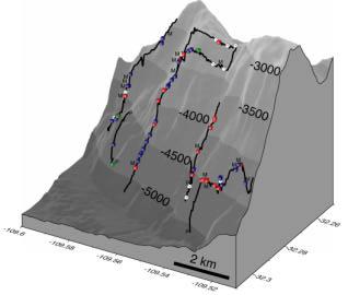


5 South Wall Rift Valley Floor North Wall
6 Problems Bow thrusters overheating on R/V Thompson at speeds < 1 kt - working out the kinks with the new DP system, or - underpowered for this type of work/weather conditions Suggestions Real-time mosaicking for DSL120 very good JASON spare parts First-time users get some experience Improved navigation flags (confidence limits?) Laser spacers Improved lighting/strobes for high-def camera Acknowledgments Capt. Phil Smith and the crew of the Thomas G. Thompson Will Sellers & the non-patriot-fans of the Deep Submergence Group Pete C, Phil F, Tom C, Dara S, Chris T, Steve G, Bob W, Cynthia S, Akel S, & Roger D. Lew Abrams, Lelsie Sonder, Chris Popham, Zach Stehley, Emily Constantine, Clay Houston, Chris Wood, Nick Deardorff This research is sponsored by the National Science Foundation OCE to U. of Rhode Island and OCE to U. of Miami
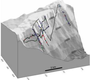
7 Martinez 6 Apr 9 May Fernando Martinez Presenter

8 R/V Kilo Moana CRUISE KM APRIL to 10 MAY, 2004 Suva, Fiji to Suva, Fiji PI s Fernando Martinez Brian Taylor Joseph A. Resing Edward T. Baker Project title: Collaborative Research: Investigating the Interrelationships between Crustal Structure, Volcanism, and Hydrothermal Activity Along the Back-Arc Eastern Lau Spreading Center (ELSC) Objectives: As the first cruise of the RIDGE 2000 Integrated Studies Site in the Lau Basin, our goals were to: Obtain a nested-resolution mapping of the entire ELSC to examine the tectonic structure and volcanism along axis. Carry out a continuous survey of hydrothermal activity along the entire ridge. These data are to be used to identify sites for more focused surveys by subsequent cruises and eventually determine the focus area for this ISS
 NESTED")

9 DSL120A IMI 30 (PORT SIDE) NESTED SIDESCAN SONAR SURVEYS SIMRAD EM120 SIDESCAN

10 39 mm/yr INCREASING SPREADING RATE 96 mm/yr
11 Chave 24 Jun 6 Jul No slides submitted
12 Reynolds 10 Jul 16 Aug Jennifer Reynolds Presenter

13 Aleutians Initiative 2004: ROV JASON II West Coast & Polar Regions Undersea Research Center (NOAA/NURP)
14 Aleutians Initiative 2004 (Leg 2) ROV JASON II Stone, Heifetz, Woodby, Reynolds, Greene (NMFS, Alaska Dept of Fish & Game, University of Alaska Fairbanks, Moss Landing Marine Laboratory) - Distribution of deep-sea corals and associated communities in the Aleutian Islands Yogodzinski, (Keleman), Scholl, (Singer) (University of South Carolina, WHOI, Moss Landing Marine Laboratory, University of Wisconsin) - Primitive plutonism in an island arc: A study of deep submarine canyons in the Western Aleutians


15
16 Aleutian Leg 2 - Jason II Dive Statistics Stone Yogodzinski TOTAL coral habitat Adak Canyon Days = days 3 days days Dives = 10 dives 3 dives 13 dives Avg hrs in water = Avg hrs on bottom = Avg km on bottom = 7.06 Avg speed (kts) = 0.26 Bio samples = corals 42 sponges 165 misc inverts Rock samples = Stone 37 Yogodzinski
17 Rathburn 10 Jul 16 Aug Elena Perez Presenter
18 Unimak Expedition: Mapping, Sampling, and Exploration of the Seafloor Offshore Unimak Island, Alaska (5 projects) July 10-24, 2004 R/V Roger Revelle/ JASON II and TOW CAM Positives: JASON II is powerful, versatile and reliable Negatives: 1)The JASON II camera & video system provides only low-resolution images. The still camera (higher resolution) did not work, and had limited capability. The low resolution images cannot be used for publication. This long-standing problem of low priority for high resolution images must be solved. We need high resolution, digital video and still cameras that can zoom and tilt to produce useable images. 2) ROV on-deck turn-around time of 8 hours (for a series of short dives) was not made known ahead of time. Advertised turn-around of a few hours presumes a series of long dives for pilot rest.
19 Origin and Evolution of Western Gulf of Alaska Seamounts PI: Randy Keller; Co-PIs: Robert Duncan and Martin Fisk (Oregon State University) 1) Created first multibeam map of a seamount (Derickson Seamount)in the area of a former ridge-ridge triple junction in the Great Magnetic Bight 2) Seamount and surrounding seafloor are being faulted by the bending of the Pacific Plate entering the trench 3) Geochemistry results have implications for understanding mass fluxes at subduction zones and Survey of Alaska Seamount Corals PI: Amy Baco-Taylor (WHOI) 1) First time corals have been observed & sampled in situ at these depths 2) 43 coral specimens were collected in water depths from 4800m to 2766m ; most were octocorals and new to science 3) Several coral taxa extend the known depth and geographic ranges
20 Biological Response to Catastrophic Disturbance on the Aleutian Margin, Gulf of Alaska PI: Tony Rathburn; Co-PIs Lisa Levin, Joris Gieskes, Jon Martin (Indiana State Univ.; SIO; Univ. of Florida) 1) Discovered new methane seep and possible new deep-sea seep community associations 2) Created the first detailed multibeam map of the the area 3) Discovered new deep-sea coral habitats 4) First to characterize the relationships between seafloor geology, geochemistry and the mosaic of biological communities in the region. Dating the Ugamak Slide PI: Gerard Fryer (Univ. Hawaii) 1) Mapped Ugamak Slide area to ascertain the origin of the 1946 tsumani presumed to have resulted from a seafloor slide 2) Results provide exciting new information and significant constraints on the characteristics of the 1946 tsunami
21 Keller 10 Jul 16 Aug -?? Randy Keller Presenter (I m not really sure which cruise he was on, but looking at the map, I would guess the Rathburn cruise)

22

23
24 Reeves-Sohn 25 Oct 10 Nov Debbie Kelley Presenter
25 Seismicity and Fluid Flow of the TAG Hydrothermal Mound - Leg 4 R/V Knorr 180-1, 10/25-11/9/04 Jason2 PIs: Reves-Sohn and Humphris (SOC participants: Green and Copley)
26 Accomplishments Temperature probe recovery (19 of 21 deployed) Tide gauge recovery High-temperature fluid samples Shrimp and crab samples SM2000 microbathymetry survey Water column hydro plume survey Chimney geological samples Push core samples Instrument testing (plume detection laser and sonar) Valley footwall visual survey and gabbro sampling
27 Comments Excellent cruise, exceeded objectives. Kudos to NDSF. Thrusters on Medea would have roughly doubled our working efficiency on-station. Upgrading resolution of video cameras (to digital still resolution) would also improve our ability to work on-station and post-process imagery.
28 Tivey 14 Nov 17 Dec Dan Fornari Presenter
29 KN180-2 Operations Summary Title: Magnetic and Structural Studies of a Lower Crustal Exposure of Ocean Lithosphere: Kane Megamullion, Mid-Atlantic Ridge 23 30'N. Co P.Is Maurice Tivey, Brian Tucholke and Henry Dick 8 Jason Dives (# includes one 1 test dive) at 4 sites - Total time ~10 days 8 ABE dives (# ) 28 dredges SeaBeam and sea surface magnetics
30 The objective of the cruise is to investigate three basic questions about the structure and evolution of slow-spreading ocean crust, and at the same time to obtain site-survey data for a proposed ODP program. The project focuses on the Kane megamullion (core-complex), which is interpreted to be the exhumed footwall of a long-lived (~1.2 m.y.) normal "detachment" fault near Kane F.Z. on 2.7 million year-old crust of the Mid-Atlantic Ridge. This exhumation exposes an upper-mantle section of lithosphere and a deep-crustal section that is readily accessible to survey, sampling, and eventual drilling. The Kane megamullion area also shows well defined magnetic lineations of chron 2A without any major disruptions, thus implying the presence of coherent source rocks. The three primary scientific questions we hope to address with this program are: How are magnetization and the polarity-reversal history of Earth's magnetic field recorded at mid-crustal and deeper levels? What conditions of magmatism at the rift axis attend formation of megamullions, and what are the resulting composition and intrusive relations at mid-crustal and deeper levels? What are the nature of strain accommodation and evolution of strain localization in the shear zone of a major normal fault in ocean crust?


31 Tivey, Tucholke, Dick Knorr Cruise Jason2, ABE & Dredge Locations (left) ABE CHIRP subbottom profile (below)
32 The objective of the cruise is to investigate three basic questions about the structure and evolution of slow-spreading ocean crust, and at the same time to obtain site-survey data for a proposed ODP program. The project focuses on the Kane megamullion (core-complex), which is interpreted to be the exhumed footwall of a long-lived (~1.2 m.y.) normal "detachment" fault near Kane F.Z. on 2.7 million year-old crust of the Mid-Atlantic Ridge. This exhumation exposes an upper-mantle section of lithosphere and a deep-crustal section that is readily accessible to survey, sampling, and eventual drilling. The Kane megamullion area also shows well defined magnetic lineations of chron 2A without any major disruptions, thus implying the presence of coherent source rocks. The three primary scientific questions we hope to address with this program are: How are magnetization and the polarity-reversal history of Earth's magnetic field recorded at mid-crustal and deeper levels? What conditions of magmatism at the rift axis attend formation of megamullions, and what are the resulting composition and intrusive relations at mid-crustal and deeper levels? What are the nature of strain accommodation and evolution of strain localization in the shear zone of a major normal fault in ocean crust?
What Forces Drive Plate Tectonics?
 What Forces Drive Plate Tectonics? The tectonic plates are moving, but with varying rates and directions. What hypotheses have been proposed to explain the plate motion? Convection Cells in the Mantle
Shape of the seafloor. Shape of the seafloor. Shape of the seafloor. Shape of the seafloor. Shape of the seafloor. Shape of the seafloor
 Multibeam echo sounders - Research vessel Scripps Institution of Oceanography R/V Roger Revelle depth Source: Scripps Institution of Oceanography http://woodshole.er.usgs.gov/project-pages/caribbean/movie1.html
Earth s Continents and Seafloors. GEOL100 Physical Geology Ray Rector - Instructor
 Earth s Continents and Seafloors GEOL100 Physical Geology Ray Rector - Instructor OCEAN BASINS and CONTINENTAL PLATFORMS Key Concepts I. Earth s rocky surface covered by of two types of crust Dense, thin,
MARINE GEOLOGY & GEOGRAPHY
 MARINE GEOLOGY MARINE GEOLOGY & GEOGRAPHY Marine Geology 4 LAYERS OF THE EARTH CRUST THICKNESS: VARIES BETWEEN OCEAN & CONTINENTS 5-40 KM STATE: SOLID ELEMENTS: SILICON, ALUMINUM, CALCIUM, SODIUM, POTASSIUM
NOAA and the National Deep Submergence Facility DEep Submergence Science Committee Meeting NOAA 2006 Report
 NOAA and the National Deep Submergence Facility DEep Submergence Science Committee Meeting NOAA 2006 Report November 9, 2006 Seattle, WA Image courtesy of the MTS 04 science team, IFE, URI/IAO NOAA and
Chapter 2 Plate Tectonics and the Ocean Floor
 Chapter 2 Plate Tectonics and the Ocean Floor Matching. Match the term or person with the appropriate phrase. You may use each answer once, more than once or not at all. 1. hydrothermal vents A. convergent
Plate Tectonics. entirely rock both and rock
 Plate Tectonics I. Tectonics A. Tectonic Forces are forces generated from within Earth causing rock to become. B. 1. The study of the origin and arrangement of Earth surface including mountain belts, continents,
1.4 Notes: Plates Converge or Scrape Past Each Other Think About Tectonic Plates Push Together at Convergent Boundaries
 1.4 Notes: Plates Converge or Scrape Past Each Other Think About If new crust is created at divergent boundaries, why does the total amount of crust on Earth stay the same? Tectonic Plates Push Together
Crustal Boundaries. As they move across the asthenosphere and form plate boundaries they interact in various ways. Convergent Transform Divergent
 Name: Date: Period: Plate Tectonics The Physical Setting: Earth Science CLASS NOTES Tectonic plates are constantly moving and interacting As they move across the asthenosphere and form plate boundaries
Chapter Overview. Bathymetry. Measuring Bathymetry. Measuring Bathymetry
 CHAPTER 3 Marine Provinces Chapter Overview The study of bathymetry determines ocean depths and ocean floor topography. Echo sounding and satellites are efficient bathymetric tools. Most ocean floor features
A) B) C) D) 4. Which diagram below best represents the pattern of magnetic orientation in the seafloor on the west (left) side of the ocean ridge?
 B) C) D) 4. Which diagram below best represents the pattern of magnetic orientation in the seafloor on the west (left) side of the ocean ridge?") 1. Crustal formation, which may cause the widening of an ocean, is most likely occurring at the boundary between the A) African Plate and the Eurasian Plate B) Pacific Plate and the Philippine Plate C)
1. Crustal formation, which may cause the widening of an ocean, is most likely occurring at the boundary between the A) African Plate and the Eurasian Plate B) Pacific Plate and the Philippine Plate C)
Full file at
 Essentials of Oceanography, 10e (Trujillo/Keller) Chapter 2 Plate Tectonics and the Ocean Floor Match the term with the appropriate phrase. You may use each answer once, more than once or not at all. A)
Plate Tectonics. 1)The plate tectonic system 2)A theory is born 3) Early evidence for continental drift 4) Continental drift and paleomagnetism
The plate tectonic system 2)A theory is born 3) Early evidence for continental drift 4) Continental drift and paleomagnetism") Plate Tectonics Plate boundaries 1)The plate tectonic system 2)A theory is born 3) Early evidence for continental drift 4) Continental drift and paleomagnetism 6)History and future of plate motions system
Plate Tectonics Plate boundaries 1)The plate tectonic system 2)A theory is born 3) Early evidence for continental drift 4) Continental drift and paleomagnetism 6)History and future of plate motions system
MARINE GEOLOGY & GEOGRAPHY
 MARINE GEOLOGY & GEOGRAPHY Bathymetry BATHYMETRY BATHYMETRY THE UNDERWATER EQUIVALENT TO TOPOGRAPHY THE STUDY OF WATER DEPTH A BATHYMETRIC MAP SHOWS FLOOR RELIEF OR TERRAIN AS CONTOUR LINES Bathymetry
Lab 1: Plate Tectonics April 2, 2009
 Name: Lab 1: Plate Tectonics April 2, 2009 Objective: Students will be introduced to the theory of plate tectonics and different styles of plate margins and interactions. Introduction The planet can be
Alfred Wegener gave us Continental Drift. Fifty years later...
 CHAPTER 2 Plate Tectonics and the Ocean Floor Plate Tectonics: summary in haiku form Alfred Wegener gave us Continental Drift. Fifty years later... Words Chapter Overview Much evidence supports plate tectonics
Bathymetry Measures the vertical distance from the ocean surface to mountains, valleys, plains, and other sea floor features
 1 2 3 4 5 6 7 8 9 10 11 CHAPTER 3 Marine Provinces Chapter Overview The study of bathymetry determines ocean depths and ocean floor topography. Echo sounding and satellites are efficient bathymetric tools.
Chapter 2 Plate Tectonics and the Ocean Floor
 Chapter 2 Plate Tectonics and the Ocean Floor Chapter Overview Much evidence supports plate tectonics theory. The plate tectonics model describes features and processes on Earth. Plate tectonic science
PLATE TECTONICS. Continental Drift. Continental Drift. Continental Drift. Continental Drift- Wegener s Evidence
 Continental Drift PLATE TECTONICS E.B. Taylor (1910) and Alfred Wegener (1915) published on Continental Drift. Continental Drift Wegener s evidence 1. Fit of the Continents 2. Fossil Evidence 3. Rock Type
Announcements. Manganese nodule distribution
 Announcements Lithospheric plates not as brittle as previously thought ESCI 322 Meet in Env. Studies Bldg Rm 60 at 1 PM on Tuesday One week (Thursday): Quiz on Booth 1994 and discussion. (Lots of odd terms
1. Name at least one place that the mid-atlantic Ridge is exposed above sea level.
 Interpreting Tectonic and Bathymetric Maps. The purpose of this lab is to provide experience interpreting the bathymetry of the seafloor in terms of tectonic and geologic settings and processes. Use the
Introduction to Oceanography. Chapter 2: Plate Tectonics Overview
 Introduction to Oceanography Chapter 2: Plate Tectonics Overview Much evidence supports plate tectonics theory. The plate tectonics model describes features and processes on Earth. Plate tectonic science
Map shows 3 main features of ocean floor
 Map shows 3 main features of ocean floor 2017 Pearson Education, Inc. Chapter 3 Marine Provinces 2017 Pearson Education, Inc. 1 Chapter 3 Overview The study of bathymetry determines ocean depths and ocean
Review participation point: The evidence for a fluid outer core is:
 DDA1 Continental Drift to Plate Tectonics PS 100 Chapter 28 Review participation point: The evidence for a fluid outer core is: A. Average density of the earth is greater than the density of the crust.
Introduction To Plate Tectonics Evolution. (Continents, Ocean Basins, Mountains and Continental Margins)
") Introduction To Plate Tectonics Evolution (Continents, Ocean Basins, Mountains and Continental Margins) Geo 386 (Arabian Shield Course) Dr. Bassam A. A. Abuamarah Mohanna G E O 3 8 6 A R A B I A N G E
Introduction To Plate Tectonics Evolution (Continents, Ocean Basins, Mountains and Continental Margins) Geo 386 (Arabian Shield Course) Dr. Bassam A. A. Abuamarah Mohanna G E O 3 8 6 A R A B I A N G E
Chapter 02 The Sea Floor
 Chapter 02 The Sea Floor Multiple Choice Questions 1. One of the following is not one of the world's major ocean basins: A. Atlantic Ocean B. Arctic Ocean C. Indian Ocean D. Antarctic Ocean E. Pacific
Essentials of Oceanography Eleventh Edition
 Chapter Chapter 1 2 Clickers Lecture Essentials of Oceanography Eleventh Edition Plate Tectonics and the Ocean Floor Alan P. Trujillo Harold V. Thurman Chapter Overview Much evidence supports plate tectonics
The Ocean Floor Earth Science, 13e Chapter 13
 The Ocean Floor Earth Science, 13e Chapter 13 Stanley C. Hatfield Southwestern Illinois College The vast world ocean Earth is often referred to as the blue planet Seventy-one percent of Earth s surface
Plate Tectonics: A Unifying Theory
 Plate Tectonics: A Unifying Theory What is Plate Tectonics? - 7 large tectonic plates and many smaller ones that break up the lithosphere - Plates are brittle and float on asthenosphere and glide past
8 th Grade Science Plate Tectonics and Topography Review
 8 th Grade Science Plate Tectonics and Topography Review #1 Scientists believe that the land masses of Earth were once joined together as one supercontinent called. A: Australia B: Wegner C: Pangaea D:
Unit 6: The Sea Floor
 Unit 6: The Sea Floor Turn to Page 62 in Introduction to the World s Oceans Study the bathymetric chart What features do you see? How do the Atlantic and Pacific Oceans differ? What do you think accounts
Ocean Basins, Bathymetry and Sea Levels
 Ocean Basins, Bathymetry and Sea Levels Chapter 4 Please read chapter 5: sediments for next class and start chapter 6 on seawater for Thursday Basic concepts in Chapter 4 Bathymetry the measurement of
Ch 9.1 Notes. Objective: Be able to explain the theory of plate tectonics and be able to explain evidence that supports it.
 Ch 9.1 Notes Objective: Be able to explain the theory of plate tectonics and be able to explain evidence that supports it. Pangaea Alfred Wegener proposed that land on Earth formed a single, huge landmass.
USU 1360 TECTONICS / PROCESSES
 USU 1360 TECTONICS / PROCESSES Observe the world map and each enlargement Pacific Northwest Tibet South America Japan 03.00.a1 South Atlantic Arabian Peninsula Observe features near the Pacific Northwest
Understanding The Seafloor. Dr. Frank R. Hall. Resources for pictures, etc. used in this presentation
 Slide 1 Understanding The Seafloor Dr. Frank R. Hall Geological Oceanographer University of New Orleans New Orleans, LA 2003 This is a presentation prepared in the Summer 2003 for the Gulf Coast COSSEE
Small area of the ocean that is partially surrounded by land. The Ocean Basins. Three Major Oceans. Three Major Oceans. What is a SEA?
 The Ocean Basins How Deep is the Ocean? 1 2 Three Major Oceans Three Major Oceans Pacific Atlantic the shallowest ocean (3.3km average depth) Indian second shallowest ocean (3.8km average depth) Pacific
Plate Tectonics. I. The Discovery of Plate Tectonics II. A Mosaic of Plates III. Types of Plate Boundaries IV. How Plates Move
 Plate Tectonics I. The Discovery of Plate Tectonics II. A Mosaic of Plates III. Types of Plate Boundaries IV. How Plates Move I. The Discovery of Plate Tectonics A. Continental Drift (Alfred Wegener) Proposed
Tsunami, earthquakes and volcanic eruptions. Tsunami, earthquakes and volcanic eruptions. Destruction of Moawhitu. Plate tectonics: terminology
 Tsunami, earthquakes and volcanic eruptions Tsunami, earthquakes and volcanic eruptions Tsunami: Wavelenths > 200 km Very fast in open ocean Destruction of Moawhitu Brian Flintoff, New Zealand Plate tectonics
1. I can describe evidence for continental drift theory (e.g., fossil evidence, mountain belts, paleoglaciation)
") Science 10 Review Earth Science Vocabulary asthenosphere continental drift theory converging plates diverging plates earthquakes epicentre fault hot spot inner core lithosphere mantle mantle convection
Science 10 Review Earth Science Vocabulary asthenosphere continental drift theory converging plates diverging plates earthquakes epicentre fault hot spot inner core lithosphere mantle mantle convection
GENERAL GEOLOGY Fall Chapter 18: The Sea Floor. Partial Examination IV Study Guide Dr. Glen S. Mattioli
 GENERAL GEOLOGY 1113-005 Fall 2008 Partial Examination IV Study Guide Dr. Glen S. Mattioli Note that these are NOT questions, but rather are a list of topics that we have covered either in class or are
Questions and Topics
 Plate Tectonics and Continental Drift Questions and Topics 1. What are the theories of Plate Tectonics and Continental Drift? 2. What is the evidence that Continents move? 3. What are the forces that
10. Paleomagnetism and Polar Wandering Curves.
 Map of ocean floor Evidence in Support of the Theory of Plate Tectonics 10. Paleomagnetism and Polar Wandering Curves. The Earth's magnetic field behaves as if there were a bar magnet in the center of
Oceanography, An Invitation to Marine Science 9e Tom Garrison. Ocean Basins Cengage Learning. All Rights Reserved.
 Oceanography, An Invitation to Marine Science 9e Tom Garrison 4 Ocean Basins Key Concepts Tectonic forces shape the seabed The ocean floor is divided into continental margins and deep ocean basins The
Captain s Tryouts 2017
 Captain s Tryouts 2017 Dynamic Planet Test Written by: Araneesh Pratap (Chattahoochee High School) Name: Date: Answer all questions on the answer sheet. Point values are given next to each question or
General Oceanography Geology 105 Expedition 8 Plate Boundaries Beneath the Sea Complete by Thursday at 11:00 PM
 General Oceanography Geology 105 Expedition 8 Plate Boundaries Beneath the Sea Complete by Thursday at 11:00 PM Name Expedition Objectives Learn about the types of plate boundaries and their key characteristics
program Hot Subduction recycling of oceanic crust in a dynamic W Pacific setting. Part 2. Principal Investigator
 S o u t h e r 2006 06 V0 0R program n S u r v e y o r voyageplan Hot Subduction recycling of oceanic crust in a dynamic W Pacific setting. Part 2. Itinerary Depart Suva, Fiji, 1600hrs Friday 18 August,
Layer Composition Thickness State of Matter
 Unit 4.2 Test Review Earth and Its Layers 1. Label the layers of the earth. oceanic crust continental crust lithosphere asthenosphere mantle outer core inner core 2. Complete the Following Table about
Marine Science and Oceanography
 Marine Science and Oceanography Marine geology- study of the ocean floor Physical oceanography- study of waves, currents, and tides Marine biology study of nature and distribution of marine organisms Chemical
ANOTHER MEXICAN EARTHQUAKE! Magnitude 7.1, Tuesday Sept. 19, 2017
 ANOTHER MEXICAN EARTHQUAKE! Magnitude 7.1, Tuesday Sept. 19, 2017 Why is there no oceanic crust older than 200 million years? SUBDUCTION If new oceanic crust is being continuously created along the earth
Lecture Outline Friday January 12 Friday January 19, 2018
 Lecture Outline Friday January 12 Friday January 19, 2018 Questions?? Key Points for today The structure of the Earth Introduction to Plate Tectonic Theory and Convection Chapter 2 Development of the Plate
Prentice Hall EARTH SCIENCE
 Prentice Hall EARTH SCIENCE Tarbuck Lutgens Chapter 9 Plate Tectonics 9.1 Continental Drift An Idea Before Its Time Wegener s continental drift hypothesis stated that the continents had once been joined
Prentice Hall EARTH SCIENCE
 Prentice Hall EARTH SCIENCE Tarbuck Lutgens Chapter 9 Plate Tectonics 9.1 Continental Drift An Idea Before Its Time Wegener s continental drift hypothesis stated that the continents had once been joined
Sea-Floor Spreading, Subduction,& Plate Boundaries. Lecture 23. Geol 101 (Kite) Quiz 9, April Geol 101 (Kite) Quiz 9, April 2006
 Quiz 9, April Geol 101 (Kite) Quiz 9, April 2006") Sea-Floor Spreading, Subduction,& Plate Boundaries Lecture 23 Prop: Test 3 Invitations Geol 101 (Kite) Quiz 9, April 2005 ******************************* * You are cordially invited * Name * to attend
Sea-Floor Spreading, Subduction,& Plate Boundaries Lecture 23 Prop: Test 3 Invitations Geol 101 (Kite) Quiz 9, April 2005 ******************************* * You are cordially invited * Name * to attend
In the space provided, write the letter of the definition that best matches the term or phrase.
 Skills Worksheet Directed Reading Section: The Changing Continents 1. What is the result of slow movements of tectonic plates? RESHAPING EARTH S CRUST In the space provided, write the letter of the definition
Plate Tectonics. Continental Drift Sea Floor Spreading Plate Boundaries
 Plate Tectonics Continental Drift Sea Floor Spreading Plate Boundaries Continental Drift 1915, Alfred Wegener - Pangea hypothesis: suggested Earth s continents were part of a large super-continent 200
Week: 4 5 Dates: 9/8 9/12 Unit: Plate Tectonics
 clementaged.weebly.com Name: ODD Period: Week: 4 5 Dates: 9/8 9/12 Unit: Plate Tectonics Monday Tuesday Wednesday Thursday Friday 7 No School 8 E 9 O *Vocabulary *Frayer Vocab *Continental Drift Notes
Sir Francis Bacon, 1620, noted that the continental coasts on opposites sides of the Atlantic fit together like puzzle pieces.
 Plate Tectonics Sir Francis Bacon, 1620, noted that the continental coasts on opposites sides of the Atlantic fit together like puzzle pieces. Could North and South America once have been joined to Europe
Outcome C&D Study Guide
 Name: Class: Outcome C&D Study Guide Identify the layers of Earth s interior Lithosphere the upper most layer of the earth that includes the crust and the hard outer mantle. It is fractured into tectonic
Civilization exists by geologic consent, subject to change without notice William Durant
 89.325 Geology for Engineers Plate Tectonics Civilization exists by geologic consent, subject to change without notice William Durant Properties of the Planets Size Density Distance from sun Chemistry
May 07- June 02 John McDonough: Ocean Exploration An Investigation of the Deep Coral Lophellia pertusa in the Northern Gulf of Mexico
 ALVIN REPORTS 2006 May 07- June 02 John McDonough: Ocean Exploration An Investigation of the Deep Coral Lophellia pertusa in the Northern Gulf of Mexico Quantifying Elemental Fluxes and Fluid Origins at
SUBSURFACE CHANGES TO EARTH. Ms. Winkle
 SUBSURFACE CHANGES TO EARTH Ms. Winkle OVERVIEW Subsurface events: occurring inside the crust and mantle Moving the lithosphere due to the convection currents in the asthenosphere Main Theories: 1912 Wegener,
Plate Tectonics: The New Paradigm
 Earth s major plates Plate Tectonics: The New Paradigm Associated with Earth's strong, rigid outer layer: Known as the lithosphere Consists of uppermost mantle and overlying crust Overlies a weaker region
Regional and Nearshore Bathymetry of American Samoa: Implications for Tsunami Run-Up and Public Awareness
 Regional and Nearshore Bathymetry of American Samoa: Implications for Tsunami Run-Up and Public Awareness Presentation U21D-07 2009 AGU Fall Meeting San Francisco Authors Dawn Wright Dept. of Geosciences,
General Oceanography Geology 105 Expedition 10 - Whole Lotta Shakin' Goin' On
 General Oceanography Geology 105 Expedition 10 - Whole Lotta Shakin' Goin' On Name Not attempting to answer questions on expeditions will result in point deductions on course workbook (two or more blank
Seafloor Spreading and Paleomagnetism Activity
 Name: PART A: Ocean Bottom Profile Background: Seafloor spreading is the hypothesis that the sea floor moves sideways away from the crest of the mid- ocean ridge. It is estimated that 20 volcanic eruptions
An Introduction of Aleutian Subduction Zone. Chuanmao Yang, Hong Yang, Meng Zhang, Wenzhong Wang 2016/04/29
 An Introduction of Aleutian Subduction Zone Chuanmao Yang, Hong Yang, Meng Zhang, Wenzhong Wang 2016/04/29 Outline General Introduction Formation history Structure from seismic study geochemical features
Non-living Resources of the OCS. Harald Brekke NPD
 Non-living Resources of the OCS Harald Brekke NPD The Continental Shelf and the Area http://www.grida.no/publications/shelf-last-zone/ Outer Continental Shelf Example http://www.grida.no/publications/shelf-last-zone/
Chapter 17. Ocean and Coastal Processes
 Chapter 17 Ocean and Coastal Processes Ocean Basins and Plates Ocean Basins Ocean Basins are profoundly different from the continents. Ocean crust is thin and dense and young. New ocean crust is generated
Unit 11: Plate Tectonics
 Unit 11: Plate Tectonics A. Alfred Wegner 1. Continental drift hypothesis a. single supercontinent called Pangaea b. 200 million years ago Pangaea (all land) began to break up and started drifting to their
Earth / Environmental Science. Ch. 14 THE OCEAN FLOOR
 Earth / Environmental Science Ch. 14 THE OCEAN FLOOR The Blue Planet Nearly 70% of the Earth s surface is covered by the global ocean It was not until the 1800s that the ocean became an important focus
Plates & Boundaries The earth's continents are constantly moving due to the motions of the tectonic plates.
 Plates & Boundaries The earth's continents are constantly moving due to the motions of the tectonic plates. As you can see, some of the plates contain continents and others are mostly under the ocean.
is a unifying theme in modern geology that integrates the earlier ideas of
 The concept of Global Plate Tectonics is a unifying theme in modern geology that integrates the earlier ideas of continental drift, sea-floor spread, and mountain building To explain why the present ocean
OS 1 The Oceans Fall 2007
 Name: Plate Tectonics (you must turn Activities 1-2 in during Section) Activity 1: Plate Boundaries A plate boundary simply describes where two plates (either oceanic or continental material) meet. There
Sea-Floor Spreading, Subduction,& Plate Boundaries. Lecture Continental Fit 2. Similar Rocks, Ages 3. Similar Fossils 4. Widespread Glaciation
 Sea-Floor Spreading, Subduction,& Plate Boundaries Lecture 21 Prop: Test 3 Invitations Alfred Wegener s Evidence for Continental Drift 1. Continental Fit 2. Similar Rocks, Ages 3. Similar Fossils 4. Widespread
OCN 201 Seafloor Spreading and Plate Tectonics. Question
 OCN 201 Seafloor Spreading and Plate Tectonics Question What was wrong from Wegener s theory of continental drift? A. The continents were once all connected in a single supercontinent B. The continents
Chapter Overview. Evidence for Continental Drift. Plate Tectonics. Evidence for Continental Drift. Evidence for Continental Drift 9/28/2010
 Chapter Overview CHAPTER 2 Plate Tectonics and the Ocean Floor Much evidence supports plate tectonics theory. Different plate boundaries have different features. Tectonic plates continue to move today.
Plate Tectonics Unit II: Plate Boundaries (3.5 pts)
") T. James Noyes, El Camino College Plate Tectonics Unit II: The Plate Boundaries (Topic 11A-2) page 1 Name: Section: Plate Tectonics Unit II: Plate Boundaries (3.5 pts) Plate Boundaries We will now discuss
T. James Noyes, El Camino College Plate Tectonics Unit II: The Plate Boundaries (Topic 11A-2) page 1 Name: Section: Plate Tectonics Unit II: Plate Boundaries (3.5 pts) Plate Boundaries We will now discuss
24. Ocean Basins p
 24. Ocean Basins p. 350-372 Background The majority of the planet is covered by ocean- about %. So the majority of the Earth s crust is. This crust is hidden from view beneath the water so it is not as
6. In the diagram below, letters A and B represent locations near the edge of a continent.
 1. Base your answer to the following question on the cross section below and on your knowledge of Earth science. The cross section represents the distance and age of ocean-floor bedrock found on both sides
Origin of the Oceans II. Earth A Living Planet. Earthquakes and Volcanoes. Plate Tectonics II
 Origin of the Oceans II Plate Tectonics II Earth A Living Planet Heat of formation of the planet is trapped at center, gradually escaping Center is nickel and iron Earthquakes and Volcanoes 1 Tracing the
MAR110 Lecture #4 Fundamentals of Plate Tectonics
 1 MAR110 Lecture #4 Fundamentals of Plate Tectonics The Ocean Sea Floor is formed Along the Mid-Ocean Ridge Spreading Centers The Ocean Sea Floor is destroyed in the Subduction Zones Figure 4.2 Convection
Plate Tectonics GEOL 101 Lecture 22 How Are Mountains Built?
 Plate Tectonics GEOL 101 Lecture 22 How Are Mountains Built? The Grand Tetons, Wyoming First a Brief Review of Sea Floor Spreading Prop: Test 3 Invitations Break-Up of a Continent and Origin of an Ocean
Along the center of the mid-ocean ridge is a rift valley that forms when the plates separate.
 Newly formed rock from rising magma rises above sea floor and forms mountain ranges known as midocean ridges. Along the center of the mid-ocean ridge is a rift valley that forms when the plates separate.
Plate Boundaries. Presented by Kesler Science
 Presented by Kesler Science Essential Questions: 1. What is plate tectonics? 2. What are the three types of plate boundaries? 3. What crustal features are formed at plate boundaries? Quick Action INB Template
General Oceanography Geology 105 Expedition 8 Plate Boundaries Beneath the Sea
 General Oceanography Geology 105 Expedition 8 Plate Boundaries Beneath the Sea Name Not attempting to answer questions on expeditions will result in point deductions on course workbook (two or more blank
UNIT 3 GEOLOGY VOCABULARY FLASHCARDS THESE KEY VOCABULARY WORDS AND PHRASES APPEAR ON THE UNIT 3 CBA
 UNIT 3 GEOLOGY VOCABULARY FLASHCARDS THESE KEY VOCABULARY WORDS AND PHRASES APPEAR ON THE UNIT 3 CBA A map that shows Earth s Topographic Map surface topography, which is Earth s shape and features Contour
Divergent Boundaries: Origin and Evolution of the Ocean Floor
 1 2 3 4 5 6 7 8 9 10 11 12 Divergent Boundaries: Origin and Evolution of the Ocean Floor Earth, 12 th Edition, Chapter 13 Chapter 13 Divergent Boundaries From 1872 to 1876, the HMS Challenger expedition
Plate Tectonics. A. Continental Drift Theory 1. Early development 2. Alfred Wegener s mechanism
 Plate Tectonics A. Continental Drift Theory 1. Early development 2. Alfred Wegener s mechanism B. Seafloor Spreading 1. Earthquakes and volcanoes 2. Seafloor maps and dates 3. Continental drift revisited
The Two Types of Crust. Plate Tectonics. Physical Layers of the Earth. The Asthenosphere. The Lithosphere. Chemical Layers of the Earth
 Plate Tectonics A Reminder of Earth s Structure Two physical units of Earth that are important too! How the Earth Works Plate Tectonics Plate Boundaries Chemical Layers of the Earth Crust - low density
Plate Boundaries & Resulting Landforms
 Plate Boundaries & Resulting Landforms Divergent Plate Boundaries (plates being pulled apart) Type: oceanic plates Description: rising magma gently lifts the crust creating a ridge. The flow of convection
Week: 4 5 Dates: 9/2 9/12 Unit: Plate Tectonics
 clementaged.weebly.com Name: ODD Period: Week: 4 5 Dates: 9/2 9/12 Unit: Plate Tectonics Monday Tuesday Wednesday Thursday Friday 1 No School 2 E 3 O *Vocabulary *Continental Drift Notes and Sea Floor
UNIT 11 PLATE TECTONICS
 UNIT 11 PLATE TECTONICS A. ALFRED WEGENER 1. Continental drift hypothesis Single supercontinent called Pangaea 200 million years ago Pangaea (all land) began to break up and started drifting to their present
Plates Moving Apart Types of Boundaries
 Plates Moving Apart Types of Boundaries PLATE TECTONICS IS The theory that the Earth s crust is broken into slabs of rock that move around on top of the asthenosphere. How fast are plates moving? The Arctic
Dynamic Crust Practice
 1. Base your answer to the following question on the cross section below and on your knowledge of Earth science. The cross section represents the distance and age of ocean-floor bedrock found on both sides
Plate Tectonics AGS 371
 Name(s) Date Period Instructions Plate Tectonics AGS 371 This lab utilizes the CD The Theory of Plate Tectonics (Advanced). The lab consists of a number of questions and diagrams regarding the development
Earth Dynamics. Landforms at Plate Boundaries
 Earth Dynamics CHAPTER 8 LESSON 2 Landforms at Boundaries What do you think? Read the two statements below and decide whether you agree or disagree with them. Place an A in the Before column if you agree
Grand Unifying Theory of everything... for the Geosciences, at least!
 Plate Tectonics: Grand Unifying Theory of everything... for the Geosciences, at least! The Earth s lithosphere, composed of Oceanic and continental crust, is broken up into pieces that move and interact
Science 10 PROVINCIAL EXAM STUDY BOOKLET. Unit 4. Earth Science
 Science 10 PROVNCAL EXAM STUDY BOOKLET Unit 4 Earth Science Student nstructions 1. Ensure that you have blank paper and a Data Booklet. 2. Record all answers on a separate piece of paper. 3. Answer keys
MAR110 Lecture #3 Ocean Bathymetry / Plate Tectonics
 1 MAR110 Lecture #3 Ocean Bathymetry / Plate Tectonics Ocean Basin Geographic Zones The geographic zones of the North Atlantic are identified in the bird s eye view of the sea floor above. Below is shown
(my) Current understanding of plate divergence processes at mid-oceanic ridges (in 24 slides)
 Current understanding of plate divergence processes at mid-oceanic ridges (in 24 slides)") (my) Current understanding of plate divergence processes at mid-oceanic ridges (in 24 slides) q 1962-2018 mid-ocean ridge processes (magmatism, tectonics, hydrothermalism) : discoveries, evolving concepts,
(my) Current understanding of plate divergence processes at mid-oceanic ridges (in 24 slides) q 1962-2018 mid-ocean ridge processes (magmatism, tectonics, hydrothermalism) : discoveries, evolving concepts,