System Mapping Case Studies
|
|
|
- Adam Nash
- 5 years ago
- Views:
Transcription


1


2 System Mapping Case Studies 1. Madison Getting Started Three Step Approach 2. Rocky Hill Maximizing resources 3. Putman Boots on the ground CT Map Rocky Hill Putnam Madison

3 Madison Community Profile Getting Started Three Step Approach Durham mi² Total Area 2,370 Catch basins 131 Town Road Miles Madison Killingly 50+ Outfalls 197 Total Road Miles Guilford Clinton TBD Miles of Pipes
4 Madison Community Profile Getting Started Three Step Approach Step 1: Develop GIS Mapping Program Database Design Catch basins Drain Manholes Outfalls Watershed Layer CB Inventory Compile Record Plans Budget Estimate Deployment Program Design Inventory Management Tool Cost Effective
 Pavement Management")

5 Madison Community Profile Getting Started Three Step Approach Step 2a: CB Inventory Base mapping (2013 Ortho Photo) Pavement Management Centerline Mapped Existing Watersheds Catch basin Mapping Methodology Create Master GeoDatabase Madison Killingly Durham Guilford Clinton

6 Madison Community Profile Getting Started Three Step Approach Step 2a: Spatially Located CB s using ArcView SCRCOG 2013 Ortho Photo Imagery Attribute Data Collected: Grate Shape (Square, Rectangle, Round) Grate Type (Type C) Street Name & Segment Watershed


7 Madison Community Profile Getting Started Three Step Approach Step 2b: Develop Mapping Estimate Developed CB Count by Watershed Compiled Available Record Plans Organized Plans by Watershed Developed Level of Effort and Cost Estimate for each Watershed
8 Madison Community Profile Getting Started Three Step Approach Step 3: System Connectivity (In Process) Use available record plans Investigate Outfalls & Close-out Systems Generate Check Plots (by Watershed) Integrate Data with CarteGraph

9 Rocky Hill Community Profile Maximizing Available Resources 13.82mi² Total Area Wethersfield Town Road Miles Total Road Miles Rocky Hill 2,288 Catch basins 250 Outfalls Cromwell Miles of Pipe


10 Rocky Hill Community Profile Maximizing Available Resources Step 1 Compiled Available Information Existing GIS & CAD Drainage Mapping Town Records & Recent Subdivision Plans 1975 MDC Record Plans Previous Outfall Inventory Developed Map Log Created Master GeoDatabase
11 Rocky Hill Community Profile Maximizing Available Resources Step 3: System Mapping Watershed Based Approach Use record plan information as primary resource for pipe connectivity Snap pipes to existing CB s, MH s and Discharge points (from GeoDatabase) Identify holes in data for assistance from Town and/or field investigation Check Plots submitted by watershed


12 Rocky Hill Community Profile Maximizing Available Resources Step 3b: Outfall Inventory/Database Converted Outfall Inspections (2005) to Database Format Created Hyperlink to Photo and Report in GIS Viewer

13 Rocky Hill Community Profile Maximizing Available Resources Step 3b: Outfall Screening (Follow-Up) Establish Inspection Parameters Confirm Existing Information Spatially Locate New Outfalls Inspect and Photograph as needed
 Sample Stormwater Check Plot : Hog Brook Watershed")
14 Rocky Hill Community Profile Maximizing Available Resources Deliverables Check Plots (24x36) Map Book (pdf) ArcReader App Storm GeoDatabase Web Platform (PeopleGIS) Sample Stormwater Check Plot : Hog Brook Watershed

15 Putnam - Community Profile Boots on the Ground mi² Total Area 66 Town Road Miles 95 Total Road Miles 1,231 Catch basins Putnam 247 Outfalls Miles of Pipe

16 Putnam - Community Profile Boots on the Ground Step 1: Asset Management Program Design Pavement, ADA & Sign Management Water & Sewer System Mapping Stormwater Management Program End-user tools Inventory Requirements Budget User Friendly
17 Putnam Comprehensive Database Design Roadway Utilities Signs Ramps Pavement Stormwater Sewer Water Point Feature Sign Type MUTCD Designation Sheeting MUTCD Compliance Point Feature Material Detectible Warning Panel ADA Compliance Line Feature Street Name Length Width Distress Types Repairs Unit Prices Line/Point Features Pipes CBs/DMHs Outfalls Material Condition Issues CB Cleaning Line/Point Features Force Mains Gravity Mains Sewer Manholes Pump Stations Condition Line/Point Features Pipes Gates Hydrants Material Condition Age All Assets interconnected to facilitate integrated CIP approach


 Systems Mapped")
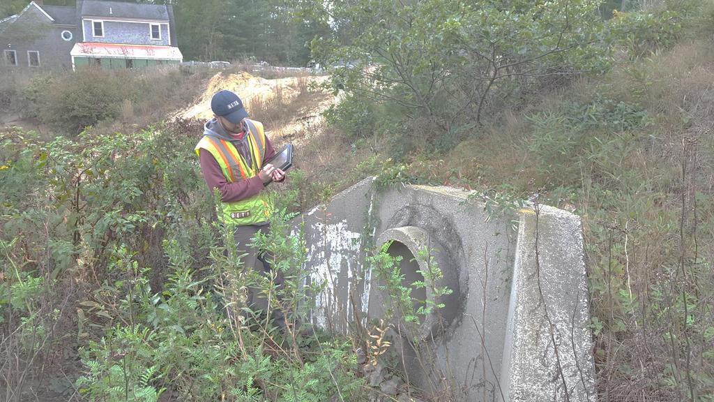
18 Putnam - Community Profile Boots on the Ground Step 2: Field Data Collection Program GIS-Based Approach (Trimble/ArcView Field Application) Systems Mapped To Discharge Point

19 Putnam - Community Profile Boots on the Ground Step 3: Deliverables MS Access Tables, Forms & Reports
20 Putnam - Community Profile Boots on the Ground Step 3: Deliverables & System Deployment Stormwater System Index Map GIS-Based Automated Processing Tools (Mapbook)


21 Putnam - Community Profile Boots on the Ground Step 3: Deployment - Tablet with Pdf Maps Android Tablet (Samsung)
22 System Design Considerations Industry Standards Compliance Measures Administrative Orders GIS Database User Input/Ideas User- Friendly
23 Building a Foundation for Decision Making CIP Analysis & Reporting Field Data Collection
24 BETA Group, Inc. Our integrated approach to projects means that our team works together to provide smart solutions to our clients needs, improving the communities where we live and work. Established: 1982 More than 145 employees in five offices: Norwood, MA Lincoln, RI Hartford, CT Manchester, NH Chicopee, MA Regional Leader in the fields of: Transportation Planning Traffic Engineering Environmental Engineering Stormwater Management Civil Engineering & Site Planning Landscape Architecture Construction Administration GIS & Asset Management Structural Engineering Environmental Science
25
Maricopa County Department of Transportation (MCDOT) GIS Innovations in Transportation Asset Management
 GIS Innovations in Transportation Asset Management") Maricopa County Department of Transportation (MCDOT) GIS Innovations in Transportation Asset Management Presented By Steve Hossack, GIS Database Administrator 2018 ITE/IMSA Spring Conference Maricopa County
Maricopa County Department of Transportation (MCDOT) GIS Innovations in Transportation Asset Management Presented By Steve Hossack, GIS Database Administrator 2018 ITE/IMSA Spring Conference Maricopa County
IH 35 at Blanco River May 2015
 IH 35 at Blanco River May 2015 Presentation Objectives Background of historical damage assessment processes Introduction to Collector App ( Mat Peck) Collector App and Flood Damage Assessment (Katie Steele)
Transforming the Maricopa County Department of Transportation (MCDOT) GIS-based Transportation Asset Inventory System June 30, 2016
 GIS-based Transportation Asset Inventory System June 30, 2016") Transforming the Maricopa County Department of Transportation (MCDOT) GIS-based Transportation Asset Inventory System June 30, 2016 Presented By Steve Hossack, GIS Database Administrator 2016 Esri User
Transforming the Maricopa County Department of Transportation (MCDOT) GIS-based Transportation Asset Inventory System June 30, 2016 Presented By Steve Hossack, GIS Database Administrator 2016 Esri User
Sewer Lateral Mapping: An Automated Approach
 Sewer Lateral Mapping: An Automated Approach MSGIC 2016 Fall Quarterly Meeting David Thaler, GISP david.thaler@ebaengineering.com EBA Engineering, Inc. 6100 Chevy Chase Drive Suite 200 Laurel, MD 20707-2917
STORMWATER ASSET MANAGEMENT:
 STORMWATER ASSET MANAGEMENT: THE ROLE OF GIS IN ASSET MANAGEMENT Janice Lerg, Hubbell, Roth & Clark, Inc. Brian McElroy, Hubbell, Roth & Clark, Inc. Kevin Fowler, Hubbell, Roth & Clark, Inc. IMAGIN CONFERENCE
MS4: MAPPING CHALLENGES. Mike Towle Associate Planner, WestCOG
 MS4: MAPPING CHALLENGES Mike Towle Associate Planner, WestCOG mtowle@westcog.org Please contact or attribute author before using any images or data from this presentation Overview I. Theory and background
Office of Enterprise Technology
 Office of Enterprise Technology Transforming the Maricopa Department of Transportation (MCDOT) GIS-based Transportation Asset Inventory System January 21, 2016 Presented By Steve Hossack, GIS Database
City of Marquette. Geographic Information Systems (GIS) Global Positioning Systems (GPS)
 Global Positioning Systems (GPS)") City of Marquette Geographic Information Systems (GIS) Global Positioning Systems (GPS) Presented by: Matthew Koss GIS Engineering Technician Email- makoss@mqtcty.org The main focus of my job at the City
City of Marquette Geographic Information Systems (GIS) Global Positioning Systems (GPS) Presented by: Matthew Koss GIS Engineering Technician Email- makoss@mqtcty.org The main focus of my job at the City
MAPPS 2012 Geospatial Products and Services Excellence Awards Awards Entry Form
 MAPPS 2012 Geospatial Products and Services Excellence Awards 2012 Awards Entry Form Please include a copy of this document with the project/product submission Entry Information Submission Number: 1741558
GIS Geographic Information Systems
 GIS Geographic Information Systems Connecting your Community Ruekert Mielke WAUKESHA WHO WE ARE DATE ESTABLISHED 1946 SERVING LOCAL PEOPLE. SOLVING LOCAL PROBLEMS. TYPE OF ORGANIZATION Ruekert & Mielke,
 Boone County GIS has the right to inquire about and investigate the use of any requested products and deny access to anyone based on concerns relating to privacy, security, public health, public safety,
Inlets to Outlets: You May Be Surprised at What You Find
 Inlets to Outlets: You May Be Surprised at What You Find TFMA Annual Conference March 10, 2016 Presented by Mike Keenum, PE, CFM Jennifer Davidson, PE Steven Nelson, PE, CFM Erin Atkinson, PE, CFM, GISP
MODERNIZATION OF THE MUNICIPAL MAPPING USING HIGH END GNSS SYSTEM AND GIS SOFTWARE
 MODERNIZATION OF THE MUNICIPAL MAPPING USING HIGH END GNSS SYSTEM AND GIS SOFTWARE Mr. R. A. R. Khan Assistant Engineer, Sewerage Utility Management Centre (SUMC) Municipal Corporation Of Greater Mumbai
MARINMAP PROJECTS
 MARINMAP PROJECTS 2013-2014 # Description EST. Cost Lead 1 Road Layer syncing to Base Map $10,000 GeoData Syncronise the ROAD featue class with changes/updates that have been made to the road network in
KING GEORGE COUNTY DEPARTMENT OF COMMUNITY DEVELOPMENT
 GIS REPORT 2016 KING GEORGE COUNTY DEPARTMENT OF COMMUNITY DEVELOPMENT Background The GIS (Geographic Information System) coordinator was hired in 2001 to develop a GIS for King George County. Prior to
Empowering water/wastewater network management with GIS
 Empowering water/wastewater network management with GIS Ioannis Kavouras_GIS Manager Surveying Engineer, MSc, MBA The Company responsible for fresh water distribution & sanitation serving 1.500.000 citizens
Oklahoma GIS for GeoCIP
 GeoCIP Program Partners Oklahoma GIS for GeoCIP A Center for Spatial Analysis Report to Oklahoma GI Council 6 November 2009 The CSA team Kathy Hines Tran Trung Semiha Caliskan Peter Camili Scott March
GeoSpatial Water Distribution, Sanitary Sewer and Stormwater Network Modeling
 2009 Bentley Systems, Incorporated GeoSpatial Water Distribution, Sanitary Sewer and Stormwater Network Modeling Angela Battisti, Gary Griffiths Bentley Systems Inc Presenter Profile Angela Battisti, CE,
BRANDON LAKES AVENUE PRE AND POST CONDITIONS DRAINAGE REPORT
 BRANDON LAKES AVENUE PRE AND POST CONDITIONS DRAINAGE REPORT Hillsborough County Public Works County Center, 22nd Floor 601 E. Kennedy Blvd. Tampa, FL 33602 BRANDON LAKES AVENUE DRAINAGE IMPROVEMENTS Capital
GIS for Planning and Revenue Collection
 GIS for Planning and Revenue Collection Laban Karanja & Barbara Seje GIS for County Government Seminar Agenda Introduction County goals County Challenges GIS as a solution for County challenges What Counties
HIGH RESOLUTION BASE MAP: A CASE STUDY OF JNTUH-HYDERABAD CAMPUS
 HIGH RESOLUTION BASE MAP: A CASE STUDY OF JNTUH-HYDERABAD CAMPUS K.Manjula Vani, Abhinay Reddy, J. Venkatesh, Ballu Harish and R.S. Dwivedi ABSTRACT The proposed work High Resolution Base map: A Case study
GIS. in the City of Lewiston Maine
 GIS in the City of Lewiston Maine The purpose of this slideshow is to provide an overview of the city GIS and how it is used, maintained and accessed in-house as well as by the public. Please simply hit
CITY OF CAPE CORAL STORMWATER MASTER PLAN PHASE II - PART 1 BASINS 4, 10, & 14 SUB-BASIN DRAINAGE IMPROVEMENTS HYDRAULIC ANALYSIS SUMMARY
 CITY OF CAPE CORAL STORMWATER MASTER PLAN PHASE II - PART 1 BASINS 4, 10, & 14 SUB-BASIN DRAINAGE IMPROVEMENTS HYDRAULIC ANALYSIS SUMMARY Cape Coral, FL Prepared for: The City of Cape Coral Public Works
Using GIS Online for tracking development of roadway construction plans. Tom Cox Viraj Perera
 Using GIS Online for tracking development of roadway construction plans Tom Cox Viraj Perera 9 Districts District 6 Located in the Capital City Springfield, IL LAND OF LINCOLN Home to: Abraham Lincoln
Ready to Respond: Improving Critical Water Line Locating with SUE and GIS
 Ready to Respond: Improving Critical Water Line Locating with SUE and GIS Matt Wetherell Town of Cary Eric Wilson KCI Technologies Shane Slaughter KCI Technologies Discussion Background Kildaire Farm Rd
Indiana GIS Resources
 Indiana GIS Resources National Association of Water Companies September 21, 2017 Jim Sparks Indiana Geographic Information Officer ABOUT THE INDIANA GEOGRAPHIC INFORMATION OFFICE I.C. 4-23-7.3 Indiana
USING GIS IN WATER SUPPLY AND SEWER MODELLING AND MANAGEMENT
 USING GIS IN WATER SUPPLY AND SEWER MODELLING AND MANAGEMENT HENRIETTE TAMAŠAUSKAS*, L.C. LARSEN, O. MARK DHI Water and Environment, Agern Allé 5 2970 Hørsholm, Denmark *Corresponding author, e-mail: htt@dhigroup.com
ArcGIS for Local Government
 Wednesday, June 29th ArcGIS for Local Government Dan Rose, GIS Analyst WaterOne IT/GIS Agenda / Talking Points What is the LGIM? WaterOne s GIS and LGIM background Our geodatabase redesign Our strategies
Developing a Campus-wide Base Map for Planning, Design and Construction. June 21, 2007
 Developing a Campus-wide Base Map for Planning, Design and Construction June 21, 2007 Presenters Berent Pippert UCR Project Manager Capital and Physical Planning Academic Planning and Budget 951-827-2431
ArcGIS Pro 3D Workflows. Zena Pelletier
 ArcGIS Pro 3D Workflows Zena Pelletier 3D as a GIS capability Core part of the platform Desktop Web Device Combine 2D and 3D in the same web GIS architecture Reuse dynamic services across clients Securely
Sea Level Rise Study Summary Town of South Bethany
 Sea Level Rise Study Summary Town of South Bethany This presentation was prepared by Anchor QEA for the Town of South Bethany using Federal Funds under award NA14 NOS 419 0123 from the Delaware Coastal
City of Milford GIS. Mark Goetz GIS Coordinator City of Milford MIS Department
 City of Milford GIS Mark Goetz GIS Coordinator City of Milford MIS Department Community Statistics Approximately 25 square miles 2000 Population 52,305 Number of Parcels 22,500 Condominiums 3,000 Commercial/Industrial
Leveraging GIS data and tools for maintaining hydraulic sewer models
 Leveraging GIS data and tools for maintaining hydraulic sewer models Ben Gamble & Joseph Koran Metropolitan Sewer District of Greater Cincinnati Carl C. Chan & Michael York CDM Smith Ben Gamble Senior
2012 Municipal Mapping Assistance Program
 2012 Municipal Mapping Assistance Program RIDEM Office of Water Resources Michaela Cashman Michael Viola November 20, 2012 Municipal Challenges Inadequate or failing drainage Urbanization and redevelopment
Enterprise Linear Referencing at the NYS Department of Transportation
 Enterprise Linear Referencing at the NYS Department of Transportation One Highway Network to Support Many Business Processes May 9, 2018 May 9, 2018 2 Agenda An overview of Linear Referencing How NYSDOT
KING GEORGE COUNTY DEPARTMENT OF COMMUNITY DEVELOPMENT
 GIS REPORT 2017 KING GEORGE COUNTY DEPARTMENT OF COMMUNITY DEVELOPMENT Background The GIS (Geographic Information System) manager was hired in 2001 to develop a GIS for King George County. Prior to 2001,
The Evolution of an Enterprise GIS at. May 3, 2007
 The Evolution of an Enterprise GIS at May 3, 2007 Franchise Area In Lee County, situated between Naples and Fort Myers including the City of Bonita Springs and South Estero, from the Collier/Lee County
Applications of Map Book Software for Local Government Agencies. Melisa Bowman Lincoln Parish GIS
 Applications of Map Book Software for Local Government Agencies Melisa Bowman Lincoln Parish GIS North Central Louisiana Parish 472 Square Miles Population: 42,000 Ruston: Largest Municipality Home to
Town of Taos Request for Proposal Historic Preservation GIS Geodatabase Project April 2007
 Town of Taos Request for Proposal Historic Preservation GIS Geodatabase Project April 2007 1. Background The Town of Taos is requesting proposals from qualified firms or a team of firms who can develop
Transforming a Grass Roots Program to an Enterprise GIS
 Transforming a Grass Roots Program to an Enterprise GIS 2 Aqua America is the second largest, publically traded water and wastewater utility Investor owned water and wastewater utility (NYSE: WTR ) 3 million
CURRICULUM VITAE Mthobeli Vaaltyn
 CURRICULUM VITAE Mthobeli Vaaltyn 2880 Dwarhane Street Browns Farm Philippi 7785 Cell: 071 3720 456 E-Mail: mvaaltyn4@gmail.com PERSONAL DETAILS Surname First Name(s) : Vaaltyn : Mthobeli Date of Birth
Coastal Viewer Mapping Application:
 Coastal Viewer Mapping Application: MAPPING OF COASTAL PUBLIC PROPERTY, THE COASTAL PROTECTION ZONE BOUNDARIES AND AUDITING OF STRUCTURES ON THE COASTAL PUBLIC PROPERTY 15 May 2014 INTEGRATED COASTAL MANAGEMENT
Climate Adaptation Challenges for Boston s Water and Sewer Systems
 National Association of Flood & Stormwater Management Agencies Climate Adaptation Challenges for Boston s Water and Sewer Systems John P Sullivan P.E. October 15,2014 Boston 1630 Boston 1630-2012 Boston
ESRI Survey Summit August Clint Brown Director of ESRI Software Products
 ESRI Survey Summit August 2006 Clint Brown Director of ESRI Software Products Cadastral Fabric How does Cadastral fit with Survey? Surveyors process raw field observations Survey measurements define high-order
ArcGIS for Local Government. Local Government. Title Placed Here
 ArcGIS for ArcGIS for Local Government Local Government Title Placed Here ArcGIS for Local Government solutions.arcgis.com/local-government Copyright 2016 Esri. All rights reserved. 151760 G73000 Address
GIS Streamlines Carlton s Sewer Improvement Process Presented by: John M. Langhans, PE Jared W. DeMaster, PE MSA Professional Services, Inc.
 GIS Streamlines Carlton s Sewer Improvement Process Presented by: John M. Langhans, PE Jared W. DeMaster, PE MSA Professional Services, Inc. November 21, 2013 APWA Conference, Brooklyn Park, MN MSA Professional
A Summary of State DOT GIS Activities. Presented at the 2000 AASHTO GIS-T Symposium Minneapolis, MN
 A Summary of State DOT GIS Activities Presented at the 2000 AASHTO GIS-T Symposium Minneapolis, MN Information Sources E-mail survey of state DOT GIS managers 49 State DOTs responded in 2000 Results compared
USING GIS TO UPDATE A FIELD SERVICES PRICING MODEL & LEVERAGING GIS TO SUPPORT FIELD DATA COLLECTION AND PUBLIC EDUCATION.
 USING GIS TO UPDATE A FIELD SERVICES PRICING MODEL & LEVERAGING GIS TO SUPPORT FIELD DATA COLLECTION AND PUBLIC EDUCATION John May, GISP THE CHALLENGE Since 1992 TxDOT has had to comply with NPDES requirements
Creation of an Internet Based Indiana Water Quality Atlas (IWQA)
") Department of Environmental Management Creation of an Internet Based Water Quality Atlas (IWQA) May 4, 2005 IUPUI 1200 Waterway Blvd., Suite 100 polis, 46202-5140 Water Quality Atlas John Buechler, Neil
Department of Environmental Management Creation of an Internet Based Water Quality Atlas (IWQA) May 4, 2005 IUPUI 1200 Waterway Blvd., Suite 100 polis, 46202-5140 Water Quality Atlas John Buechler, Neil
Louisiana Transportation Engineering Conference. Monday, February 12, 2007
 Louisiana Transportation Engineering Conference Monday, February 12, 2007 Agenda Project Background Goal of EIS Why Use GIS? What is GIS? How used on this Project Other site selection tools I-69 Corridor
e-pathai GIS (Electronic Project, Administration, Traffic, Highway Assets and Information management system) in Tamil Nadu Highways
 in Tamil Nadu Highways") e-pathai GIS (Electronic Project, Administration, Traffic, Highway Assets and Information management system) in Tamil Nadu Highways Er.G.Kumar¹, Er.R.Sendel Raj², Er.P.Eshwarmoorthy³, Dr.P.Rajakumar 4
e-pathai GIS (Electronic Project, Administration, Traffic, Highway Assets and Information management system) in Tamil Nadu Highways Er.G.Kumar¹, Er.R.Sendel Raj², Er.P.Eshwarmoorthy³, Dr.P.Rajakumar 4
Steve Pietersen Office Telephone No
 Steve Pietersen Steve.Pieterson@durban.gov.za Office Telephone No. 031 311 8655 Overview Why geography matters The power of GIS EWS GIS water stats EWS GIS sanitation stats How to build a GIS system EWS
What s New in Collector for ArcGIS (Aurora)
") What s New in Collector for ArcGIS (Aurora) Derek Law (dlaw@esri.com) Esri Apps Product Management @GIS_Bandit Oct 10 th, 2018 Agenda Product overview Use cases Preparing data for Collector for ArcGIS
What s New in Collector for ArcGIS (Aurora) Derek Law (dlaw@esri.com) Esri Apps Product Management @GIS_Bandit Oct 10 th, 2018 Agenda Product overview Use cases Preparing data for Collector for ArcGIS
MS4 General Permit City of West Haven 2018 Annual Report Existing MS4 Permittee Permit Number GSM January 1, 2018 December 31, 2018
 MS4 General Permit City of West Haven 2018 Annual Report Existing MS4 Permittee Permit Number GSM 000002 January 1, 2018 December 31, 2018 This report documents City s efforts to comply with the conditions
Los Angeles County Storm Drain Initiative
 Los Angeles County Storm Drain Initiative By Sean Christian, PE May 2007 TABLE OF CONTENTS STORM DRAIN INTITIATIVE ABSTRACT 2 PROJECT BACKGROUND, NEEDS, AND OBJECTIVES 2 Project Needs 2 Project Objectives
Evaluating e-government : implementing GIS services in Municipality
 Evaluating e-government : implementing GIS services in Municipality Municipality of Thessaloniki - G.I.S. Unit Misirloglou Symeon Head of the GIS Unit ESRI UC - 2016 The GIS Section - subset of the department
Cobb County GIS: Beyond the Map
 Cobb County GIS: Beyond the Map Charles Fail Tim Scharff Cobb County GIS SERUG 2008 1 Topics Cobb GIS Overview The Early Years Enterprise GIS Transition Putting It Together Looking Ahead SERUG 2008 2 Cobb
GIS Monroe Geographic Information System March 14, 2018
 GIS Monroe Geographic Information System March 14, 2018 Goals Maintain Enterprise/County-wide geo-database Increase spatial accuracy of data Build and acquire more data layers Increase use of GIS; as another
The purpose of this report is to recommend a Geographic Information System (GIS) Strategy for the Town of Richmond Hill.
 Strategy for the Town of Richmond Hill.") Staff Report for Committee of the Whole Meeting Department: Division: Subject: Office of the Chief Administrative Officer Strategic Initiatives SRCAO.18.12 GIS Strategy Purpose: The purpose of this report
Staff Report for Committee of the Whole Meeting Department: Division: Subject: Office of the Chief Administrative Officer Strategic Initiatives SRCAO.18.12 GIS Strategy Purpose: The purpose of this report
Appendix C. Questionnaire Summary of Responses Geographic Information Systems
 Appendix C Questionnaire Summary of Responses Geographic Information Systems 1. Is your agency using or planning use of GIS for: a. general mapping (e.g. highway routes, political boundaries, etc.) b.
GIS-T 2010 Building a Successful Geospatial Data Sharing Framework: A Ohio DOT Success Story
 GIS-T 2010 Building a Successful Geospatial Data Sharing Framework: A Ohio DOT Success Story ODOT District 2 GIS John Puente District 1 GIS Coordinator\ Planning Administrator 2 Interoperability 3 District
TFMA Spring Conference Houston, Texas March 10, 2016 PROJECT TEAM:
 TFMA Spring Conference Houston, Texas March 10, 2016 PROJECT TEAM: Brown, Leal & Associates R. Gutierrez Engineering ERO Architects Administered by the Texas Water Development Board History of the Study
Road Ahead: Linear Referencing and UPDM
 Road Ahead: Linear Referencing and UPDM Esri European Petroleum GIS Conference November 7, 2014 Congress Centre, London Your Work Making a Difference ArcGIS Is Evolving Your GIS Is Becoming Part of an
Process Simplification Office of the Vice President for Management and Budget. University Mapping Implementation Team (UMapIT) Final Report
 Final Report") Process Simplification Office of the Vice President for Management and Budget University Mapping Implementation Team (UMapIT) Final Report Table of Contents Introduction...3 Definitions...3 UMI Recommendations...3
Process Simplification Office of the Vice President for Management and Budget University Mapping Implementation Team (UMapIT) Final Report Table of Contents Introduction...3 Definitions...3 UMI Recommendations...3
Implementation of GISystems in the Land Acquisition Process and Road Maintenance. Immaculate Katutsi Uganda National Roads Authority
 Implementation of GISystems in the Land Acquisition Process and Road Maintenance Immaculate Katutsi Uganda National Roads Authority Stage 1 Stage 2 Stage 3 2 The Road construction process/ Project flow
Inflow and Infiltration. John Sorrell, P.E. City of Raleigh Public Utilities Department
 Inflow and Infiltration John Sorrell, P.E. City of Raleigh Public Utilities Department 1 Raleigh s History with I&I Our initial system was designed in 1888. Treatment began in the 1950 s What is I & I?
BUILDING AN ASSET MANAGEMENT GEODATABASE FOR RANCHING. Matt Crawford, GISP
 BUILDING AN ASSET MANAGEMENT GEODATABASE FOR RANCHING Matt Crawford, GISP Introduction East Foundation Formed in 2007 Mission Research Education Outreach Properties Six ranches ~ 215,000 acres San Antonio
Severe Storm Response Version # 1-0-1
 Severe Storm Response Version # 1-0-1 Weather Warnings Environment Canada issues severe weather warnings, watches and advisories Weather Watch Severe weather may develop. Weather Warning Severe weather
Data Aggregation with InfraWorks and ArcGIS for Visualization, Analysis, and Planning
 Data Aggregation with InfraWorks and ArcGIS for Visualization, Analysis, and Planning Stephen Brockwell President, Brockwell IT Consulting, Inc. Join the conversation #AU2017 KEYWORD Class Summary Silos
ADDENDUM NO. 1 TO THE BIDDING /CONTRACT DOCUMENTS AND SPECIFICATIONS CITY OF COCOA BEACH BID NO: CB15-002
 ADDENDUM NO. 1 TO THE BIDDING /CONTRACT DOCUMENTS AND SPECIFICATIONS CITY OF COCOA BEACH GEOGRAPHIC INFORMATION SYSTEM (GIS) SERVICES CONTRACT BID NO: CB15-002 March 11, 2016 To All Interested Bidders:
Creating a Sewer Geodatabase Model for the City of Torrance.
 Creating a Sewer Geodatabase Model for the City of Torrance. Jennifer Gough, City of Torrance Tam Tu, City of Torrance Latha Palakur, DCSE Haritha Vendra, DCSE Introduction The City of Torrance is located
"GIS-Sofia" Ltd. geospatial data integration in SOFCAR geographic information system and providing services March 2018, Sofia
 "GIS-Sofia" Ltd. geospatial data integration in SOFCAR geographic information system and providing services Geographical Information System Sofia " Ltd....the beginning... Established in 1999, as a Sofia
Building a GIS with Limited Resources
 Building a GIS with Limited Resources VILLAGE OF LOMBARD Daniel Price, GIS Technician David Dratnol, Village Engineer About Lombard... 22 Miles from downtown Chicago 43,251 Residents (28th among 272 NIPC
No. of Days. Building 3D cities Using Esri City Engine ,859. Creating & Analyzing Surfaces Using ArcGIS Spatial Analyst 1 7 3,139
 Q3 What s New? Creating and Editing Data with ArcGIS Pro Editing and Maintaining Parcels Using ArcGIS Spatial Analysis Using ArcGIS Pro User Workflows for ArcGIS Online Organizations Q3-2018 ArcGIS Desktop
Executive Summary Name: Company: Name of Project: Awards Result:
 Executive Summary Name: Dwayne Honor Company: Bundaberg Regional Council Name of Project: Streamlining Workflows The Integration of 12d, 12d Field and GIS Awards Result: Third Place (Tied) For many years
Clean Water 2020 Program
 Clean Water 2020 Program SEWER MAPPING PROGRAM July 2014 Submitted to EPA SCDHEC July 17, 2014 Table of Contents Program Summary and Intent... 2 Section 1. Sewer Mapping Program Objectives... 5 Section
What is GIS and How Can It Help Me?
 esri European User Conference Madrid 2011 What is GIS and How Can It Help Me? Jaime Nieves Ignacio Vázquez esri spain «Knowing where things are, and why, is essential to rational decision making.» Jack
E14- Integrating Civil Design, Mapping and Geospatial Data
 www.bentley.com E14- Integrating Civil Design, Mapping and Geospatial Data Lisa Whitson, Transportation and Local Infrastructure Professional Services, Bentley Systems USA GIS and Engineering Data Integration
Annual TTFO Meeting April 10, 2018 Michael J. Wittman, P.S. Chief Surveyor / GIS Coordinator
 Annual TTFO Meeting April 10, 2018 Michael J. Wittman, P.S. Chief Surveyor / GIS Coordinator Text Book Definition: Layman Terms: An organized collection of hardware, software and geographic data designed
STREUVER FIDELCO CAPPELLI, LLC YONKERS DOWNTOWN DEVELOPMENT PHASE 1. DRAFT ENVIRONMENTAL IMPACT STATEMENT For: PALISADES POINT
 STREUVER FIDELCO CAPPELLI, LLC YONKERS DOWNTOWN DEVELOPMENT PHASE 1 DRAFT ENVIRONMENTAL IMPACT STATEMENT For: PALISADES POINT Prepared by: PAULUS, SOKOLOWSKI & SARTOR STORMWATER MANAGEMENT 1. Methodology
Building a National Data Repository
 Building a National Data Repository Mladen Stojic, Vice President - Geospatial 1/30/2013 2012 Intergraph Corporation 1 Information has meaning and gives power only when shared and distributed. Information,
SURVEYING (SUR) Surveying (SUR) 1
 Surveying (SUR) 1") Surveying (SUR) 1 SURVEYING (SUR) SUR 111: Plane Surveying Plane surveying principles; basic measurement statistics; use and care of equipment; traversing, area, and coordinate computations; differential
Surveying (SUR) 1 SURVEYING (SUR) SUR 111: Plane Surveying Plane surveying principles; basic measurement statistics; use and care of equipment; traversing, area, and coordinate computations; differential
UNION SANITARY DISTRICT
 UNION SANITARY DISTRICT UNION CITY, CA GIS Application of Wastewater Treatment Plant Infrastructure Union Sanitary District Regional Wastewater District Serve the cities of Fremont, Newark and Union City
JOB DESCRI PTI ON. GIS Administrator
 JOB DESCRI PTI ON JOB GRADE: GS-0 Cla ss Code : Office - 8 8 0 DEPARTMENT: 2 0 - FLSA: EXEMPT JOB NO: 6-0 9-2 7 SALARY: To Be De t e rm in e d Job description statements are intended to describe the general
Brian D. George. GIMS Specialist Ohio Coastal Atlas Project Coordinator and Cartographer. Impacts and Outcomes of Mature Coastal Web Atlases
 Ohio Coastal Atlas Project Brian D. George GIMS Specialist Ohio Coastal Atlas Project Coordinator and Cartographer Ohio Department of Natural Resources Office of Coastal Management Sandusky, OH Impacts
Using Public Information and Graphics Software in Graduate Highway Safety Research at Worcester Polytechnic Institute
 Using Public Information and Graphics Software in Graduate Highway Safety Research at Worcester Polytechnic Institute C.E. Conron, C. Silvestri, A. Gagne, M.H. Ray Department of Civil and Environmental
CLICK HERE TO KNOW MORE
 CLICK HERE TO KNOW MORE Integrating GIS data for Water Distribution Modeling Case Study: General Directorate of Water Eng. Atif Karrani - GIS Manager karrani@sewa.gov.ae Agenda Introduction Enterprise
APWA New England Chapter 2015 Winter Snow Stories. Winter Snow Stories
 APWA New England Chapter 2015 Winter Snow Stories APWA North American Snow Conference, Hartford, CT May 25, 2016 Winter Snow Stories 1 Winter Snow Stories Today s Team of Public Works Experts Tom Collins,
Comptroller GIS and Property Data. Ken Morrell Assessment Systems Manager Division of Property Assessments February 22, 2007
 Comptroller GIS and Property Data Ken Morrell Assessment Systems Manager Division of Property Assessments February 22, 2007 Comptroller Divisions Using and Supporting GIS Office of Local Government Implement
Managing an Extreme Weather Event of Prolonged Duration May 22, 2013
 Managing an Extreme Weather Event of Prolonged Duration May 22, 2013 MISSOURI RIVER FLOOD OF 2011 M I C H A E L J. K E N N E R L Y P. E. D I R E C T O R O F T H E O F F I C E O F D E S I G N I O W A D
StreamStats: Delivering Streamflow Information to the Public. By Kernell Ries
 StreamStats: Delivering Streamflow Information to the Public By Kernell Ries U.S. Department of the Interior U.S. Geological Survey MD-DE-DC District 410-238-4317 kries@usgs.gov StreamStats Web Application
Village of Algonquin Geographic Information Systems. Village of Algonquin. Development Plan of Geographic Information Systems
 Village of Algonquin Development Plan of Geographic Information Systems 014-019 10/1/013 1 GIS Development Plan A. Purpose The purpose of this document is to outline a strategic plan for Geographic Information
LRS Task Force June 13, REVISION HISTORY
 North Carolina Department of Transportation Geographic Information Systems (GIS) Unit LINEAR REFERENCING SYSTEM (LRS) PROJECT DEFINITION Version 1.0 REVISION HISTORY Date Document Manager Revision Purpose
Preparing GIS Data for NG9-1-1 in the Commonwealth of Virginia
 Preparing GIS Data for NG9-1-1 in the Commonwealth of Virginia Brian Crumpler Regional Coordinator Virginia Information Technologies Agency (VITA) February 28, 2017 1 1 Overview: Sharing ways Virginia
2016 APWA Snow Conference. Web-based GIS for Municipal Snow Operations
 2016 APWA Snow Conference Web-based GIS for Municipal Snow Operations Christopher M. Cignoli, P.E. - Director of Public Works, Springfield, MA Bob Houldson - Director IT Services for the Department of
A Temporal Hydrologic Database for Rapidly Changing Landscapes
 A Temporal Hydrologic Database for Rapidly Changing Landscapes Using Mt. St. Helens in Washington as a Pilot Site Adam Mosbrucker Geog 575 BACKGROUND: Client / User U.S. Geological Survey Cascades Volcano
A GIS TOUR OF DES MOINES PRESENTED BY ANNA WHIPPLE, GIS MANAGER APRIL 20, 2015
 A GIS TOUR OF DES MOINES PRESENTED BY ANNA WHIPPLE, GIS MANAGER APRIL 20, 2015 Welcome to Des Moines! Capital of Iowa Among 100 largest metropolitan areas Insurance, biotech, healthcare, and entertainment
Building GIS for Fairfax County Wastewater Management. Gilbert Osei-Kwadwo
 Abstract: Building GIS for Fairfax County Wastewater Management Gilbert Osei-Kwadwo Wastewater Management Agency (WWM) of Fairfax County in Virginia has put a lot of efforts into building an effective
Driving efficiencies across in-field and centralised. Collector for ArcGIS. Georges River Council. NSW Department of Education
 This image will be updated Driving efficiencies across in-field and centralised operations Bushfire using Risk Collector for ArcGIS Georges River Council NSW Department of Education About Cardno About
GENERALIZATION IN THE NEW GENERATION OF GIS. Dan Lee ESRI, Inc. 380 New York Street Redlands, CA USA Fax:
 GENERALIZATION IN THE NEW GENERATION OF GIS Dan Lee ESRI, Inc. 380 New York Street Redlands, CA 92373 USA dlee@esri.com Fax: 909-793-5953 Abstract In the research and development of automated map generalization,