USING GIS TO UPDATE A FIELD SERVICES PRICING MODEL & LEVERAGING GIS TO SUPPORT FIELD DATA COLLECTION AND PUBLIC EDUCATION.
|
|
|
- Ethelbert Weaver
- 6 years ago
- Views:
Transcription
1 USING GIS TO UPDATE A FIELD SERVICES PRICING MODEL & LEVERAGING GIS TO SUPPORT FIELD DATA COLLECTION AND PUBLIC EDUCATION John May, GISP
2 THE CHALLENGE Since 1992 TxDOT has had to comply with NPDES requirements Map and Inspect Outfalls Along TxDOT Roadways In Urbanized Areas


3 WHAT IS AN OUTFALL? The point of a conveyance at which a discharge enters waters of the U.S.
4 HOW MANY OUTFALLS DOES TXDOT THINK THEY HAVE? 1 stream crossing every 2,000 feet X 4 outfalls per crossing = 10.5 outfalls per mile 79,000 miles of roads X 10.5 = 829,500 outfalls Fortunately only urbanized areas need to be mapped

5 WHERE ARE THE URBANIZED AREAS?
6 FORT WORTH STUDY AREA 212 miles of TxDOT roads within city limits 559 estimated stream crossings 2,236 estimated outfalls

7 FORT WORTH STUDY AREA

8 FORT WORTH STUDY AREA TXDOT ROADS

9 FORT WORTH STUDY AREA CITY LIMITS

10 FORT WORTH STUDY AREA TXDOT ROADS IN FORT WORTH

11 FORT WORTH STUDY AREA FORECAST STREAM CROSSINGS

12 FORT WORTH STUDY AREA FORECAST CROSSINGS & STREAMS

13 FORT WORTH STUDY AREA GIS IDENTIFIED CROSSINGS

14 FORT WORTH STUDY AREA NOT ALL CROSSINGS ARE CROSSINGS

15 FORT WORTH STUDY AREA NOT ALL CROSSINGS HAVE OUTFALLS

16 FORT WORTH STUDY AREA NOT ALL CROSSINGS HAVE OUTFALLS
17 FORT WORTH STUDY AREA OUTFALL LOCATIONS

18 FORT WORTH STUDY AREA FORECAST LOCATIONS

19 FORT WORTH STUDY AREA ACTUAL LOCATIONS
20 RESULTS 559 = Forecast crossings using TxDOT method 158 = Forecast crossings using GIS method 2,236 = Forecast outfalls using TxDOT method 632 = Forecast outfalls using GIS method 155 = Field verified outfalls (60 crossings) 10.5 = Forecast outfalls per mile (TxDOT method) 0.73 = Field verified outfalls per mile TxDOT method over predicts outfalls 14 fold!
21 RESULTS Analysis Zone TxDOT Roadway Miles Forecast outfalls Outfalls identified during field survey Outfalls Per Mile Fort Worth 212 2, El Paso 200 2, Totals 412 4,
22 Leveraging Your GIS Data Field data collection can be tedious Locate the outfall Record an inspection Update a database back in the office Online GIS can streamline the work Web maps can be used for data collection Web maps can be used for reporting Web maps can be used for public education
23 Many Different Online Tools Available Arcgis Online GisCloud GeoCommons Mango Map MapCite Google Fusion Tables CartoDB Google Earth

24 ArcGIS Online

25 ArcGIS Online
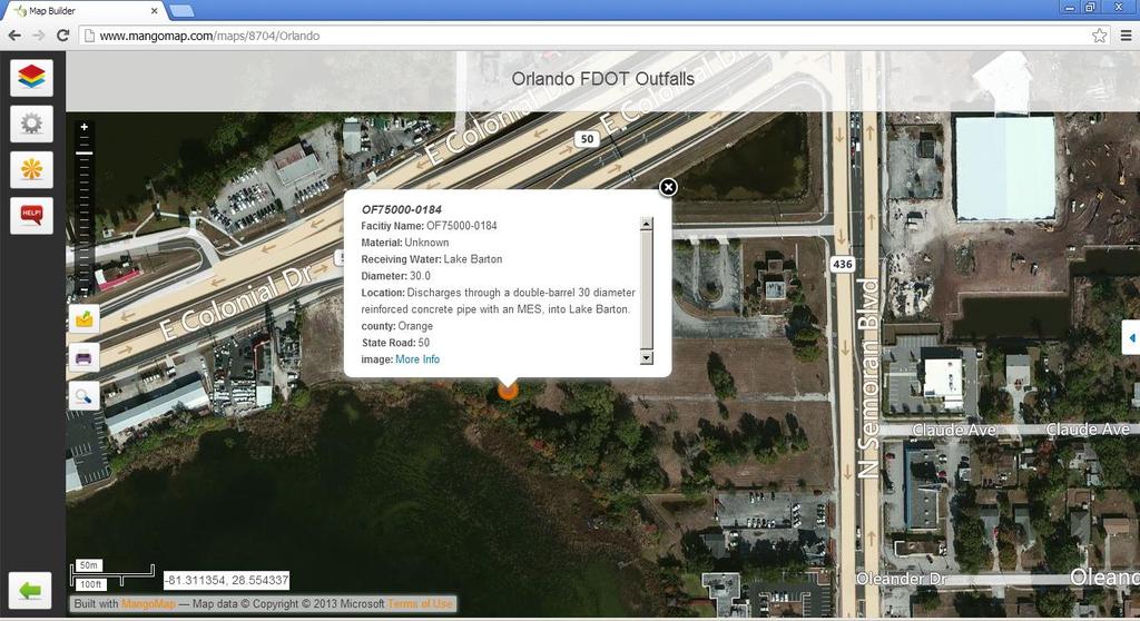
26 ArcGIS Online Pros Collaborative/Teams Location Sensors Supports Hyperlinks Private and Public Maps Good Basemap Selections ESRI Product Cons ESRI Product Expensive Certain Features Require Desktop Integration Limited GIS Functionality
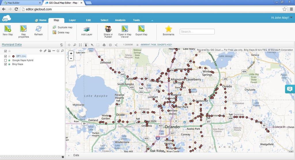
27 GIS Cloud
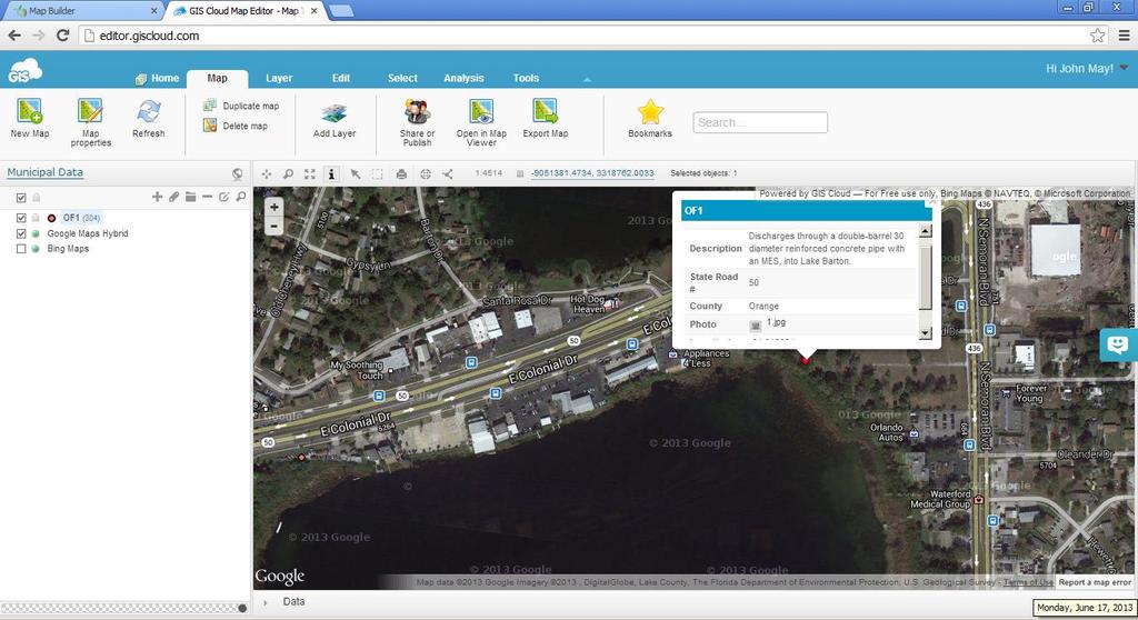
28 GIS Cloud
29 GIS Cloud Pros Collaborative/Teams Location Sensors Supports Hyperlinks Private and Public Maps Data Import/Export Good Basemap Selections True GIS Functionality Cons Complex Interface PostGIS Requirements More a GIS than a Map Server
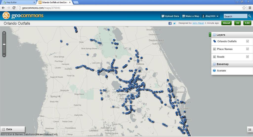
30 GeoCommons
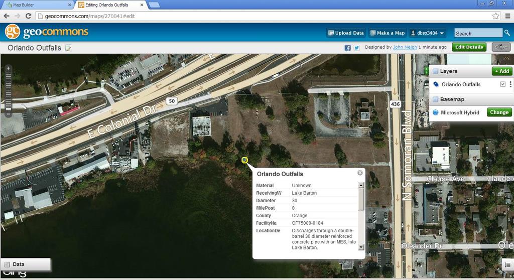
31 GeoCommons
32 GeoCommons Pros Collaborative/Teams Private and Public Maps Data Import/Export Good Basemap Selections Easy Interface Free Cons Does not support Hyperlinks No Editing Ability No Location Sensors Purhased by ESRI
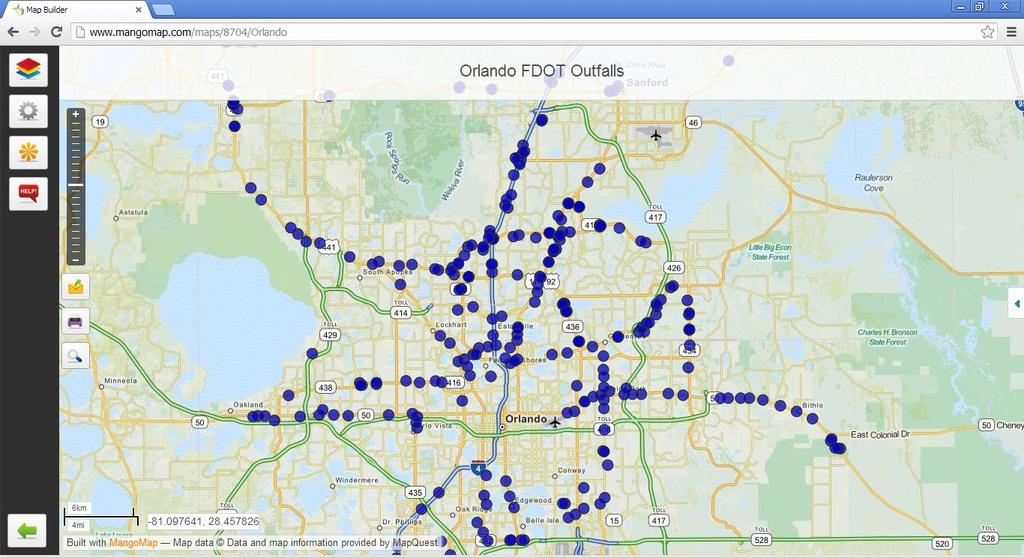
33 Mango Map
34 Mango Map
35 Mango Map Pros Collaborative/Teams Private and Public Maps Supports Hyperlinks Data Import/Export Good Basemap Selections Easy Interface Free Cons No Editing Ability No Location Sensors
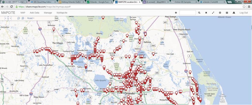
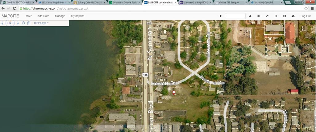
36 MapCite
37 MapCite
38 Mapcite Pros Private and Public Maps Supports Hyperlinks Data Import Good Basemap Selections Easy Interface Cons Data Conversion Errors No Location Sensors No Data Export Expensive Bugs

39 Google Fusion Tables
40 Google Fusion Tables
41 Google Fusion Tables Pros Private and Public Maps Data Import Multiple Table Capabilities Attribute Editing Only Familiar Interface Free Cons Experimental No Hyperlink Support No Location Sensors Cannot Create Data on Map
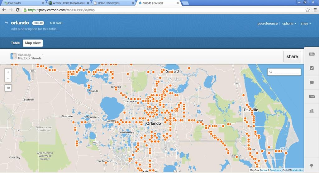
42 CartoDB
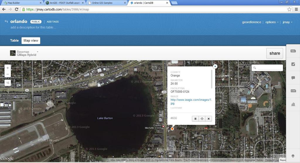
43 CartoDB
44 CartoDB Pros Private and Public Maps Data Import/Export Attribute Editing Only Good Basemap Inexpensive Cons Data Conversion Errors No Location Sensors Cannot Create Data on Map

45 Google Earth

46 Google Earth
47 Google Earth Pros Public Maps Good Basemap Free Cons Data Import Requirements No Location Sensors Cannot Export data Requires Software Only Useful for Viewing
48 QUESTIONS? John May Technology Client Manager
Leveraging the GIS Capability within FlexiCadastre
 Managing Local Land Concerns, Maintaining Corporate Governance Leveraging the GIS Capability within FlexiCadastre Regional User Conference, North America May 6 th May 9 th, 2013 Cameron McKellar, Technical
Gridded Traffic Density Estimates for Southern
 Gridded Traffic Density Estimates for Southern California, 1995-2014 User Notes authored by Beau, 11/28/2017 METADATA: Each raster file contains Traffic Density data for one year (1995, 2000, 2005, 2010,
Demystifying ArcGIS Online. Karen Lizcano Esri
 Demystifying ArcGIS Online Karen Lizcano Esri An Integrated Web GIS Platform Desktop Web Device Powered by Services Managed via Portal Access from any Device Portal Server Online Content and Services ArcGIS
The Emerging Role of Enterprise GIS in State Forest Agencies
 The Emerging Role of Enterprise GIS in State Forest Agencies Geographic Information System (GIS) A geographic information system (GIS) is a computer software system designed to capture, store, manipulate,
Lecture 3 GIS outputs. Dr. Zhang Spring, 2017
 Lecture 3 GIS outputs Dr. Zhang Spring, 2017 Model of the course Using and making maps Navigating GIS maps Map design Working with spatial data Geoprocessing Spatial data infrastructure Digitizing File
Changes in Esri GIS, practical ways to be ready for the future
 Changes in Esri GIS, practical ways to be ready for the future John Sharrard, Esri April 16, 2015 The only thing that is constant is change. Heraclitus, ca. 500 B.C. My story (of experiencing change) Changes
Managing Parcels in ArcGIS 10
 Managing Parcels in ArcGIS 10 ArcGIS Geodatabase Editing Workflows Editing Maps Tim Hensley Esri Solution Engineer Karen Lowrey Esri Geospatial Analyst Basemaps Public Access Value Analysis ArcGIS 10 Parcel
Incorporating ArcGIS Pro in your Curriculum
 AAG, Boston 2017 April 5, 2017 Incorporating ArcGIS Pro in your Curriculum Geri Miller Agenda Concerns Acknowledged Learning curve ArcGIS Pro does not have all the tools (perception) Licensing and offline
What Would John Snow Do (Today)? Part 1
? Part 1") What Would John Snow Do (Today)? Part 1 Tanya Bigos and Derek Law @Tanyabigos @GIS_Bandit Thurs Oct 19 th, 2017 Outline Overview of the ArcGIS Platform Whiteboard discussion Summary Questions A Whole New
What Would John Snow Do (Today)? Part 1 Tanya Bigos and Derek Law @Tanyabigos @GIS_Bandit Thurs Oct 19 th, 2017 Outline Overview of the ArcGIS Platform Whiteboard discussion Summary Questions A Whole New
Web GIS: Architectural Patterns and Practices. Shannon Kalisky Philip Heede
 Web GIS: Architectural Patterns and Practices Shannon Kalisky Philip Heede Web GIS Transformation of the ArcGIS Platform Desktop Apps Server GIS Web Maps Web Scenes Layers Web GIS Transformation of the
Web GIS & ArcGIS Pro. Zena Pelletier Nick Popovich
 Web GIS & ArcGIS Pro Zena Pelletier Nick Popovich Web GIS Transformation of the ArcGIS Platform Desktop Apps GIS Web Maps Web Scenes Layers Evolution of the modern GIS Desktop GIS (standalone GIS) GIS
European Location Framework data in the ArcGIS platform
 European Location Framework data in the ArcGIS platform Presentation to: Author: Date: INSPIRE Conference 2016 Clemens Portele 26 September 2016 Why ELF? Global (e.g. UN GGIM) Regional Europe (INSPIRE
Leveraging Interactive AJAX Web Tools for Online Maps
 Leveraging Interactive AJAX Web Tools for Online Maps Presentation at GeoWeb 2009 Academic Track Steven Romalewski CUNY Mapping Service The Graduate Center / City University of New York July 2009 1 The
Leveraging ArcGIS Server Technology
 Leveraging ArcGIS Server Technology A Local Government Approach Virginia Johnston GIS Systems Analyst Virginia Beach 39 th Largest city in the United States 438,000 Residents City by the Sea Located in
Introduction to ArcGIS Maps for Office. Greg Ponto Scott Ball
 Introduction to ArcGIS Maps for Office Greg Ponto Scott Ball Agenda What is Maps for Office? Platform overview What are Apps for the Office? ArcGIS Maps for Office features - Visualization - Geoenrichment
What s New in Collector for ArcGIS (Aurora)
") What s New in Collector for ArcGIS (Aurora) Derek Law (dlaw@esri.com) Esri Apps Product Management @GIS_Bandit Oct 10 th, 2018 Agenda Product overview Use cases Preparing data for Collector for ArcGIS
What s New in Collector for ArcGIS (Aurora) Derek Law (dlaw@esri.com) Esri Apps Product Management @GIS_Bandit Oct 10 th, 2018 Agenda Product overview Use cases Preparing data for Collector for ArcGIS
Mapping Historical Information Using GIS
 Mapping Historical Information Using GIS David Yun, GISP Troy Lawson ABSTRACT The City of San Luis Obispo, California, is rich with history. It is one of California s oldest communities that began with
Leveraging ArcGIS Online Elevation and Hydrology Services. Steve Kopp, Jian Lange
 Leveraging ArcGIS Online Elevation and Hydrology Services Steve Kopp, Jian Lange Topics An overview of ArcGIS Online Elevation Analysis Using Elevation Analysis Services in ArcGIS for Desktop Using Elevation
Web GIS Administration: Tips and Tricks
 EdUC 2017 July 8 th, 2017 Web GIS Administration: Tips and Tricks Geri Miller Agenda Concerns Acknowledged User Management Content Management Monitoring Licensing and logins Sophistication of IT support
ArcGIS Earth for Enterprises DARRON PUSTAM ARCGIS EARTH CHRIS ANDREWS 3D
 ArcGIS Earth for Enterprises DARRON PUSTAM ARCGIS EARTH CHRIS ANDREWS 3D ArcGIS Earth is ArcGIS Earth is a lightweight globe desktop application that helps you explore any part of the world and investigate
Introduction to Portal for ArcGIS. Hao LEE November 12, 2015
 Introduction to Portal for ArcGIS Hao LEE November 12, 2015 Agenda Web GIS pattern Product overview Installation and deployment Security and groups Configuration options Portal for ArcGIS + ArcGIS for
Geospatial Fire Behavior Modeling App to Manage Wildfire Risk Online. Kenyatta BaRaKa Jackson US Forest Service - Consultant
 Geospatial Fire Behavior Modeling App to Manage Wildfire Risk Online Kenyatta BaRaKa Jackson US Forest Service - Consultant Fire Behavior Modeling and Forest Fuel Management Modeling Fire Behavior is an
June 19 Huntsville, Alabama 1
 June 19 Huntsville, Alabama 1 Real-Time Geospatial Data: The Fusion of PI and ArcGIS Enabling Smarter Facilities Management OSIsoft and Esri Mapping and Location Analytics Platform Supporting Your Use
ADDING RCGEO BASEMAPS TO ARCMAP. Versions 10.0, 10.1 and 10.1 sp1
 ADDING RCGEO BASEMAPS TO ARCMAP Versions 10.0, 10.1 and 10.1 sp1 May, 2014 Contents Adding the Ortho and Carto Base Maps to ArcMap... 2 Richland County Base Maps... 2 Adding the Base Map Connections ArcMap
Introduction to Portal for ArcGIS
 Introduction to Portal for ArcGIS Derek Law Product Management March 10 th, 2015 Esri Developer Summit 2015 Agenda Web GIS pattern Product overview Installation and deployment Security and groups Configuration
Regional GIS and GIS Alternatives. Carl Zimmerman, PhD Senior GIS Manager
 Regional GIS and GIS Alternatives Carl Zimmerman, PhD Senior GIS Manager Data Availability Imagery now available for entire region. 3 and 4-band imagery Data Availability Imagery now available for entire
Maricopa County Department of Transportation (MCDOT) GIS Innovations in Transportation Asset Management
 GIS Innovations in Transportation Asset Management") Maricopa County Department of Transportation (MCDOT) GIS Innovations in Transportation Asset Management Presented By Steve Hossack, GIS Database Administrator 2018 ITE/IMSA Spring Conference Maricopa County
Maricopa County Department of Transportation (MCDOT) GIS Innovations in Transportation Asset Management Presented By Steve Hossack, GIS Database Administrator 2018 ITE/IMSA Spring Conference Maricopa County
ArcGIS Earth an Intro
 ArcGIS Earth an Intro Chris Andrews Product Manager, 3D and ArcGIS Earth Brian Sims 3D Content Lead 3D across the Esri product family ArcGIS Pro 3D Analyst CityEngine ArcGIS for Server ArcGIS Online ArcGIS
Lecture 11. Data Standards and Quality & New Developments in GIS
 Lecture 11 Data Standards and Quality & New Developments in GIS Lecture 11: Outline I. Data Standards and Quality 1. Types of Spatial Data Standards 2. Data Accuracy II. New Developments/The Future of
Features and Benefits
 Autodesk LandXplorer Features and Benefits Use the Autodesk LandXplorer software family to help improve decision making, lower costs, view and share changes, and avoid the expense of creating physical
StreamStats: Delivering Streamflow Information to the Public. By Kernell Ries
 StreamStats: Delivering Streamflow Information to the Public By Kernell Ries U.S. Department of the Interior U.S. Geological Survey MD-DE-DC District 410-238-4317 kries@usgs.gov StreamStats Web Application
Strategies for Integrating CAD and BIM in ArcGIS. Don Kuehne Esri 3D Product Manager: CAD/BIM/AEC
 Strategies for Integrating CAD and BIM in ArcGIS Don Kuehne Esri 3D Product Manager: CAD/BIM/AEC CAD Digital Drawing CAD in ArcGIS Desktop CAD in Desktop CAD as Data CAD as a Map EXPORT TO CAD Create and
Driving efficiencies across in-field and centralised. Collector for ArcGIS. Georges River Council. NSW Department of Education
 This image will be updated Driving efficiencies across in-field and centralised operations Bushfire using Risk Collector for ArcGIS Georges River Council NSW Department of Education About Cardno About
Enabling ENVI. ArcGIS for Server
 Enabling ENVI throughh ArcGIS for Server 1 Imagery: A Unique and Valuable Source of Data Imagery is not just a base map, but a layer of rich information that can address problems faced by GIS users. >
Pictometry GIS and Integration Solutions. Presented by Peter White, GISP GIS Product Manager, Pictometry International Corp.
 Pictometry GIS and Integration Solutions Presented by Peter White, GISP GIS Product Manager, Pictometry International Corp. 1. Pictometry Web Integration Solutions 2. Advanced LiDAR Sensor and Solutions
ELF products in the ArcGIS platform
 ELF products in the ArcGIS platform Presentation to: Author: Date: NMO Summit 2016, Dublin, Ireland Clemens Portele 18 May 2016 The Building Blocks 18 May, 2016 More ELF users through affiliated platforms
Climate Risk Visualization for Adaptation Planning and Emergency Response
 Climate Risk Visualization for Adaptation Planning and Emergency Response NCR Flood Fact Finding Workshop Ricardo Saavedra ricardo@vizonomy.com Social Media, Mobile, and Big Data St. Peter s Basilica,
Development of a Web-Based GIS Management System for Agricultural Authorities in Iraq
 Development of a Web-Based GIS Management System for Agricultural Authorities in Iraq USCID Water Management Conference Phoenix, Arizona April 18, 2013 Gabriele Bonaiti Extension Program Specialist David
Transforming the Maricopa County Department of Transportation (MCDOT) GIS-based Transportation Asset Inventory System June 30, 2016
 GIS-based Transportation Asset Inventory System June 30, 2016") Transforming the Maricopa County Department of Transportation (MCDOT) GIS-based Transportation Asset Inventory System June 30, 2016 Presented By Steve Hossack, GIS Database Administrator 2016 Esri User
Transforming the Maricopa County Department of Transportation (MCDOT) GIS-based Transportation Asset Inventory System June 30, 2016 Presented By Steve Hossack, GIS Database Administrator 2016 Esri User
Geography for the 2020 Round of Census
 Boundaries Key Census Data EA Id Population Male Female EA Id Area EA Id Num HH Avg HH size Geography for the 2020 Round of Census Linda Peters, Esri lpeters@esri.com Integration of Statistical and Geospatial
Export Basemap Imagery from GIS to CAD
 Export Basemap Imagery from GIS to CAD This tutorial illustrates how to add high resolution imagery as a basemap into an existing CAD drawing using ArcGIS and AutoCAD. Through this method, the imagery
OC Enterprise GIS. Kevin Hills, PLS Cameron Smith, GISP. OC Survey
 OC Enterprise GIS Kevin Hills, PLS Cameron Smith, GISP OC Survey Discussion Points Background & Organizational Structure of OCPW Past practices prior to Enterprise Wide GIS License (ELA) Participating
RESOLUTION NO
 RESOLUTION NO. 09-2017 Adopting Job Descriptions for Engineering and GIS Manager and GIS Analyst and Amending the Pay Resolution to Accommodate Said Positions and Amending the Staffing Chart to Accommodate
ArcGIS Enterprise: What s New. Philip Heede Shannon Kalisky Melanie Summers Sam Williamson
 ArcGIS Enterprise: What s New Philip Heede Shannon Kalisky Melanie Summers Sam Williamson ArcGIS Enterprise is the new name for ArcGIS for Server What is ArcGIS Enterprise ArcGIS Enterprise is powerful
Embracing ArcGIS Server Technology A City s Balanced Approach
 Embracing ArcGIS Server Technology A City s Balanced Approach Sridhar Katragadda Virginia Johnston Esri UC2013. About the City Virginia Beach Metropolitan Statistical Area (MSA) is the 38th largest in
Gridded Ambient Air Pollutant Concentrations for Southern California, User Notes authored by Beau MacDonald, 11/28/2017
 Gridded Ambient Air Pollutant Concentrations for Southern California, 1995-2014 User Notes authored by Beau, 11/28/2017 METADATA: Each raster file contains data for one pollutant (NO2, O3, PM2.5, and PM10)
Abstract: Traffic accident data is an important decision-making tool for city governments responsible for
 Kalen Myers, GIS Analyst 1100 37 th St Evans CO, 80620 Office: 970-475-2224 About the Author: Kalen Myers is GIS Analyst for the City of Evans Colorado. She has a bachelor's degree from Temple University
ArcGIS for Desktop. ArcGIS for Desktop is the primary authoring tool for the ArcGIS platform.
 ArcGIS for Desktop ArcGIS for Desktop ArcGIS for Desktop is the primary authoring tool for the ArcGIS platform. Beyond showing your data as points on a map, ArcGIS for Desktop gives you the power to manage
GIS FOR PLANNING. Course Overview. Schedule. Instructor. Prerequisites. Urban Planning 792 Thursday s 5:30-8:10pm SARUP 158
 GIS FOR PLANNING Urban Planning 792 Thursday s 5:30-8:10pm SARUP 158 Schedule Class/Lab - SARUP 158 Thursdays 5:30pm - 8:10pm Office Hours - By Appointment Project Ideas - Week 4 Final - 5/10/2018 Instructor
Office of Technology Partnerships GIS Collaboration
 Office of Technology Partnerships GIS Collaboration State GIS Update April 21, 2017 Mark Holmes, GISP Outline MGF Upgrade Project Census Programs Imagery Update LiDAR Update Open Discussion 2 MGF Background
GIS Resources for Local Governments
 ISSUE PAPER SERIES GIS Resources for Local Governments February 2018 NEW YORK STATE TUG HILL COMMISSION DULLES STATE OFFICE BUILDING 317 WASHINGTON STREET WATERTOWN, NY 13601 (315) 785-2380 WWW.TUGHILL.ORG
VCCS Geospatial Institute 2011
 John McGee Jennifer McKee With support from: NSF DUE-0903270 Acquiring and Downloading Digital Data in partnership with: Geospatial Technician Education Through Virginia s Community Colleges (GTEVCC) Review
NR402 GIS Applications in Natural Resources
 NR402 GIS Applications in Natural Resources Lesson 1 Introduction to GIS Eva Strand, University of Idaho Map of the Pacific Northwest from http://www.or.blm.gov/gis/ Welcome to NR402 GIS Applications in
Why GIS & Why Internet GIS?
 Why GIS & Why Internet GIS? The Internet bandwagon Internet mapping (e.g., MapQuest) Location-based services Real-time navigation (e.g., traffic) Real-time service dispatch Business Intelligence Spatial
ArcGIS Online Tools and Water-Related Web Services You Can Use Every Day of Your Life!
 ArcGIS Online Tools and Water-Related Web Services You Can Use Every Day of Your Life! Brian Rowley, PE, CFM FMA 2014 Annual Conference 1 Gold Rush (49ers) John Sutter Sutter s Mill South fork of American
Techniques for Science Teachers: Using GIS in Science Classrooms.
 Techniques for Science Teachers: Using GIS in Science Classrooms. After ESRI, 2008 GIS A Geographic Information System A collection of computer hardware, software, and geographic data used together for
You are Building Your Organization s Geographic Knowledge
 You are Building Your Organization s Geographic Knowledge And Increasingly Making it Available Sharing Data Publishing Maps and Geo-Apps Developing Collaborative Approaches Citizens Knowledge Workers Analysts
Geometric Algorithms in GIS
 Geometric Algorithms in GIS GIS Visualization Software Dr. M. Gavrilova GIS Software for Visualization ArcView GEO/SQL Digital Atmosphere AutoDesk Visual_Data GeoMedia GeoExpress CAVE? Visualization in
GIS. in the City of Lewiston Maine
 GIS in the City of Lewiston Maine The purpose of this slideshow is to provide an overview of the city GIS and how it is used, maintained and accessed in-house as well as by the public. Please simply hit
Portal for ArcGIS: An Introduction
 Portal for ArcGIS: An Introduction Derek Law Esri Product Management Esri UC 2014 Technical Workshop Agenda Web GIS pattern Product overview Installation and deployment Security and groups Configuration
Esri and GIS Education
 Esri and GIS Education Organizations Esri Users 1,200 National Government Agencies 11,500 States & Regional Agencies 30,800 Cities & Local Governments 32,000 Businesses 8,500 Utilities 12,600 NGOs 11,000
Among various open-source GIS programs, QGIS can be the best suitable option which can be used across partners for reasons outlined below.
 Comparison of Geographic Information Systems (GIS) software As of January 2018, WHO has reached an agreement with ESRI (an international supplier of GIS software) for an unlimited use of ArcGIS Desktop
GIS Functions and Integration. Tyler Pauley Associate Consultant
 GIS Functions and Integration Tyler Pauley Associate Consultant Contents GIS in AgileAssets products Displaying data within AMS Symbolizing the map display Display on Bing Maps Demo- Displaying a map in
ArcGIS is Advancing. Both Contributing and Integrating many new Innovations. IoT. Smart Mapping. Smart Devices Advanced Analytics
 ArcGIS is Advancing IoT Smart Devices Advanced Analytics Smart Mapping Real-Time Faster Computing Web Services Crowdsourcing Sensor Networks Both Contributing and Integrating many new Innovations ArcGIS
You Part of a Global Network of GIS Businesses. Your Work Making a Difference. Understanding Our World, with Web GIS, SDI and 3D
 Understanding Our World, with Web GIS, SDI and 3D Paul Hardy, Esri phardy@esri.com You Part of a Global Network of GIS Businesses XIV International User Conference of GeoInformation Systems & Remote Sensing,
Office of Enterprise Technology
 Office of Enterprise Technology Transforming the Maricopa Department of Transportation (MCDOT) GIS-based Transportation Asset Inventory System January 21, 2016 Presented By Steve Hossack, GIS Database
SHOW ME THE DATA. FEMA Region 6 Community Assistance Visits Findings Collector
 SHOW ME THE DATA FEMA Region 6 Community Assistance Visits Findings Collector Roberto Ramirez, CFM / ASFPM June 4, 2015 Topics of Discussion Overview of CAV Findings Collection project Why a GIS Based
Bentley Map Advancing GIS for the World s Infrastructure
 Bentley Map Advancing GIS for the World s Infrastructure Presentation Overview Why would you need Bentley Map? What is Bentley Map? Where is Bentley Map Used? Red text signifies new things in Bentley Map
Enterprise Linear Referencing at the NYS Department of Transportation
 Enterprise Linear Referencing at the NYS Department of Transportation One Highway Network to Support Many Business Processes May 9, 2018 May 9, 2018 2 Agenda An overview of Linear Referencing How NYSDOT
ArcGIS Pipeline Referencing An Introduction. Anjali Bhangay William Isley
 ArcGIS Pipeline Referencing An Introduction Anjali Bhangay William Isley Pipeline Referencing Overview Information Model Pipeline Referencing Overview Information Model ArcGIS Pro Pipeline Referencing
The GIS Path Forward Saskatchewan s Geomatics Strategic Plan
 The GIS Path Forward Saskatchewan s Geomatics Strategic Plan John Potter, SK Ministry of Central Services Office of Geomatics Coordination Sept.17/13 Table of Contents 1. 2011-2016, Geomatics Strategic
ArcGIS for Local Government
 Wednesday, June 29th ArcGIS for Local Government Dan Rose, GIS Analyst WaterOne IT/GIS Agenda / Talking Points What is the LGIM? WaterOne s GIS and LGIM background Our geodatabase redesign Our strategies
How does ArcGIS Server integrate into an Enterprise Environment? Willy Lynch Mining Industry Specialist ESRI, Denver, Colorado USA
 How does ArcGIS Server integrate into an Enterprise Environment? Willy Lynch Mining Industry Specialist ESRI, Denver, Colorado USA wlynch@esri.com ArcGIS Server Technology Transfer 1 Agenda Who is ESRI?
Rural Louisiana. A quarterly publication of the Louisiana Tech Rural Development Center
 Rural Louisiana A quarterly publication of the Louisiana Tech Rural Development Center Volume 4, No. 1, Fall 2009 Editor: Aaron K. Lusby Director, Asst. Professor Newsletter design: Stephanie Tidwell Student
GIS Level 2. MIT GIS Services
 GIS Level 2 MIT GIS Services http://libraries.mit.edu/gis Email: gishelp@mit.edu TOOLS IN THIS WORKSHOP - Definition Queries - Create a new field in the attribute table - Field Calculator - Add XY Data
The Changing Face of Geospatial Technology
 The Changing Face of Geospatial Technology Vincent A. DiNoto, Jr. Director of GeoTech Center Vince.dinoto@kctcs.edu Based upon work supported by the National Science Foundation under Grant DUE ATE 1304591.
Lecture 2. Introduction to ESRI s ArcGIS Desktop and ArcMap
 Lecture 2 Introduction to ESRI s ArcGIS Desktop and ArcMap Outline ESRI What is ArcGIS? ArcGIS Desktop ArcMap Overview Views Layers Attribute Tables Help! Scale Tips and Tricks ESRI Environmental Systems
IH 35 at Blanco River May 2015
 IH 35 at Blanco River May 2015 Presentation Objectives Background of historical damage assessment processes Introduction to Collector App ( Mat Peck) Collector App and Flood Damage Assessment (Katie Steele)
ArcGIS Urban: An Introduction. Lisa Staehli ArcGIS Urban Team Product Development Brooks Patrick ArcGIS Urban Team Business Development
 ArcGIS Urban: An Introduction Lisa Staehli ArcGIS Urban Team Product Development Brooks Patrick ArcGIS Urban Team Business Development Our Cities Are Facing Massive Challenges Our Cities Are Facing Massive
Personal Field Data Collection by UM-FieldGIS (Integration of Google Map API to Mobile GIS)
") Personal Field Data Collection by UM-FieldGIS (Integration of Google Map API to Mobile GIS) Ko Ko Lwin*. Yuji MURAYAMA* *Division of Spatial Information Science Graduate School of Life and Environmental
Personal Field Data Collection by UM-FieldGIS (Integration of Google Map API to Mobile GIS) Ko Ko Lwin*. Yuji MURAYAMA* *Division of Spatial Information Science Graduate School of Life and Environmental
Bridging the Gap between Engineering and GIS
 Bridging the Gap between Engineering and GIS Presented by: Karen Stewart, B.Tech, GISP Manager of Geomatics Township of Langley February 13, 2006 Agenda Introduction History Goals Implementation Benefits
Innovation in Land Management: Integrated Solutions For National Cadastre Projects
 Success With GIS Innovation in Land Management: Integrated Solutions For National Cadastre Projects XXIII International FIG Congress Munich These documents are only complete, when used in connection with
Map Application Progression
 Map Application Progression Application Migration with Latest ArcGIS by Dean Chiang California Department of Fish and Wildlife What we do at CDFW Hunting and fishing licensing and regulation Conservation
Lecture 12. Data Standards and Quality & New Developments in GIS
 Lecture 12 Data Standards and Quality & New Developments in GIS Lecture 12: Outline I. Data Standards and Quality 1. Types of Spatial Data Standards 2. Data Accuracy 3. III. Documenting Spatial Data Accuracy
Making spatial data available on the desktop
 Making spatial data available on the desktop Loch Lomond and The Trossachs National Park Authority (LLTNPA) Sally Newton GIS Manager Francis Corbett GIS Systems Officer Where we were in 2010 What we wanted
A Vision for ArcGIS Applying Geography Everywhere
 A Vision for ArcGIS Applying Geography Everywhere WELCOME PURPOSE A Network of GIS Professionals Are Awakening the World to the Power of Web GIS You Your WORK Making a Difference Your Work Open Maps and
Migrating Defense Workflows from ArcMap to ArcGIS Pro. Renee Bernstein and Jared Sellers
 Migrating Defense Workflows from ArcMap to ArcGIS Pro Renee Bernstein and Jared Sellers ArcGIS Desktop Desktop Web Device ArcMap ArcCatalog ArcScene ArcGlobe ArcGIS Pro portal Server Online Content and
Esri Production Mapping: An Introduction
 Esri Production Mapping: An Introduction Amber Bethell & Joseph Sheffield Esri UC 2014 Technical Workshop Your organization s processes Collect Share Manage Produce Your organization s needs Standardization
GPS Mapping with Esri s Collector App. What We ll Cover
 GPS Mapping with Esri s Collector App Part 1: Overview What We ll Cover Part 1: Overview and requirements Part 2: Preparing the data in ArcGIS for Desktop Part 3: Build a web map in ArcGIS Online Part
Esri s Living Atlas of the World Community Maps
 Esri s Living Atlas of the World Community Maps Seth Sarakaitis Wednesday May 7, 2014 ArcGIS Living Atlas Concept Living Atlas Content Tour Contributing to the Living Atlas (Community Maps) Seth Sarakaitis
Inception to Completion: The Project Design Workflow. Southwest User Group April 10, 2018 Broomfield, CO
 1 Inception to Completion: The Project Design Workflow Southwest User Group April 10, 2018 Broomfield, CO 2 Tools Trimble GPS Survey grade (S6) Mapping grade (6000) Trimble V10 imaging rover Trimble Business
Sharing GIS to Empower the End User David Wray, Roanoke County, Virginia
 Sharing GIS to Empower the End User David Wray, Roanoke County, Virginia Sharing GIS to Empower the End User Roanoke County, Virginia Roanoke County, Virginia Population: 92,901 Area: 251 Square Miles
Data Aggregation with InfraWorks and ArcGIS for Visualization, Analysis, and Planning
 Data Aggregation with InfraWorks and ArcGIS for Visualization, Analysis, and Planning Stephen Brockwell President, Brockwell IT Consulting, Inc. Join the conversation #AU2017 KEYWORD Class Summary Silos
These modules are covered with a brief information and practical in ArcGIS Software and open source software also like QGIS, ILWIS.
 Online GIS Training and training modules covered are: 1. ArcGIS, Analysis, Fundamentals and Implementation 2. ArcGIS Web Data Sharing 3. ArcGIS for Desktop 4. ArcGIS for Server These modules are covered
Leveraging Web GIS: An Introduction to the ArcGIS portal
 Leveraging Web GIS: An Introduction to the ArcGIS portal Derek Law Product Management DLaw@esri.com Agenda Web GIS pattern Product overview Installation and deployment Configuration options Security options
Base Maps: Creating, Using & Participating
 Base Maps: Creating, Using & Participating Michael Fashoway & Erin Geraghty Montana Base Map Service Center 2010 MAGIP Technical Session October 28, 2010 What is a Base Map? Using a Base Map Creating a
Working with ArcGIS Online
 Esri International User Conference San Diego, CA Technical Workshops July 12, 2011 Working with ArcGIS Online Bern Szukalski, Deane Kensok Topics for this Session ArcGIS Online Overview ArcGIS Online Content
The (new) GIS Toolkit:
 GIS Toolkit:") The (new) GIS Toolkit: Mixing and matching open source and commercial GIS tools to meet individual GIS needs and goals Randal Hale - NRGS Carol Kraemer - NRGS Why limit yourself to one solution? Fulcrum
The (new) GIS Toolkit: Mixing and matching open source and commercial GIS tools to meet individual GIS needs and goals Randal Hale - NRGS Carol Kraemer - NRGS Why limit yourself to one solution? Fulcrum
JOB DESCRI PTI ON. GIS Administrator
 JOB DESCRI PTI ON JOB GRADE: GS-0 Cla ss Code : Office - 8 8 0 DEPARTMENT: 2 0 - FLSA: EXEMPT JOB NO: 6-0 9-2 7 SALARY: To Be De t e rm in e d Job description statements are intended to describe the general
Google Maps and Beyond
 Google Maps and Beyond Aaron Paul First American Title apaul@firstam.com 2015 APRA Symposium Association of Professional Reserve Analysts May 2 nd, 2015 Google Maps and Beyond - Overview Business case