Inception to Completion: The Project Design Workflow. Southwest User Group April 10, 2018 Broomfield, CO
|
|
|
- Edwina Alexander
- 5 years ago
- Views:
Transcription

1 1 Inception to Completion: The Project Design Workflow Southwest User Group April 10, 2018 Broomfield, CO
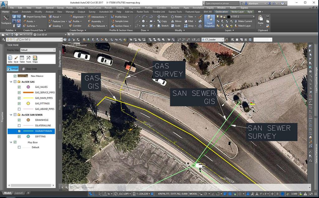
2 2 Tools Trimble GPS Survey grade (S6) Mapping grade (6000) Trimble V10 imaging rover Trimble Business Center AutoDesk Civil 3D/Raster Design GeoExpress GIS ArcGIS Enterprise SDE on a SQLServer platform nearmap imagery Parcel Fabric
3 3
4 4 What is Inception Through Completion? Initial concept basemap Survey Engineering Design Construction Documents Construction As-built Documents

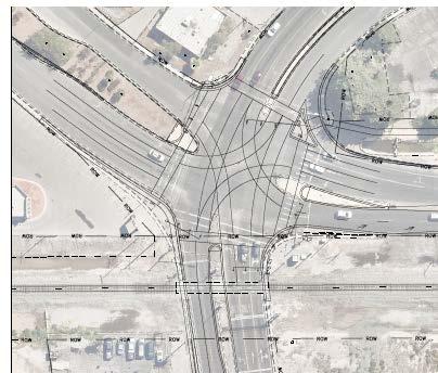
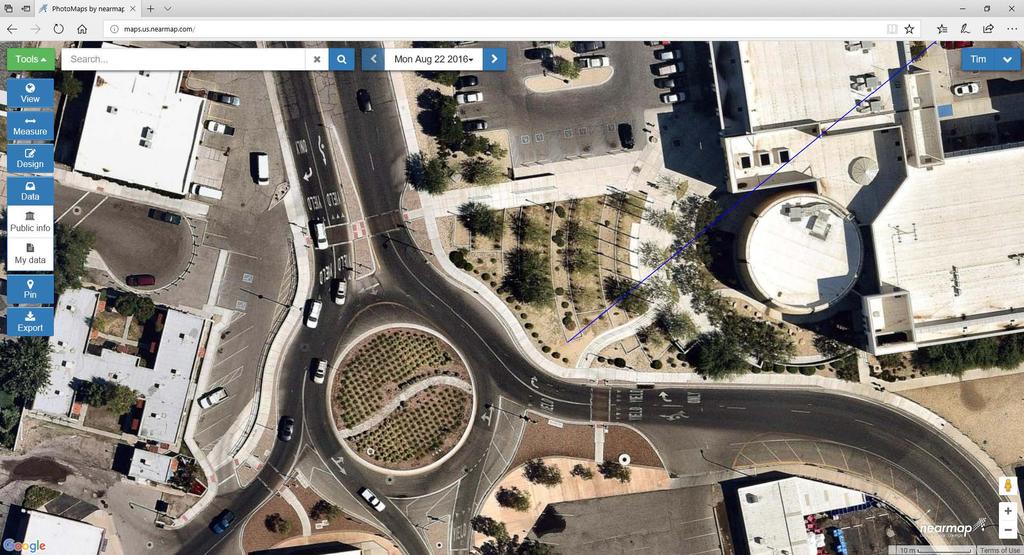
5 Proposed Road Diet 5
6 6
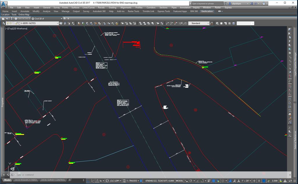
7 7 Basemap Base Tables Parcel Ownership Table Research Table (GIS, Book/Page, Ownership, Care-of, Address, etc) Title Parcels/Ownership Accuracy; Currency ROW/Ownership Agreements; Historic; Takes Gaps and overlaps Seniority of title--rr, EBID vs private parcels
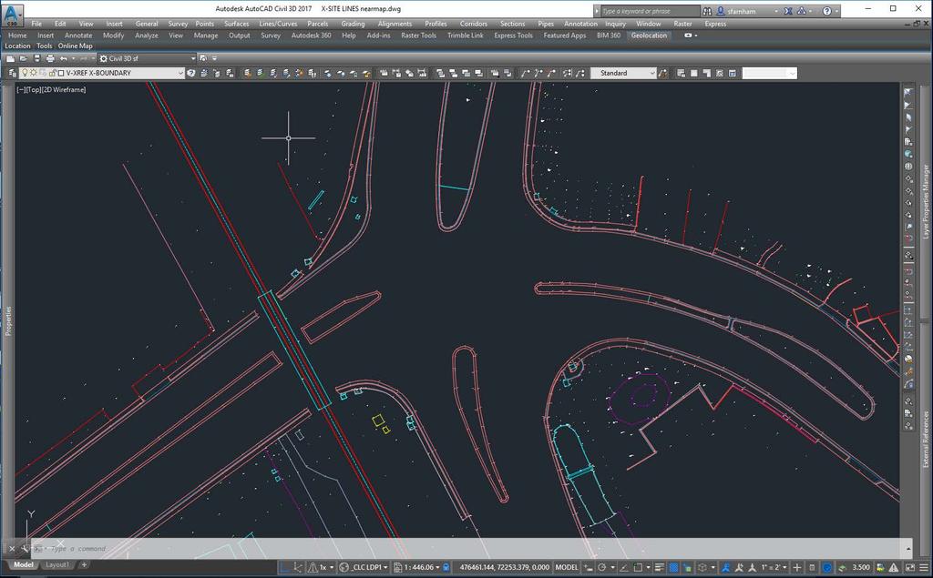
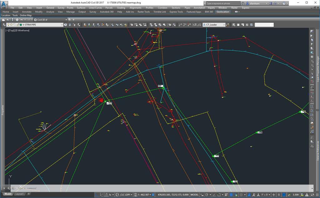
8 8 Basemap, cont. Aerial Imagery Registration to local projection Low Distortion Projection Topography 2 ft contours possible 3D surface Utilities City-owned Gas, Water, Sewer, Storm, Fiber Optics Private Electricity, Telephone, Cable/FO, Water, Gas Basemap becomes basis for survey planning Early transfer to design engineers for Conceptual or Preliminary Design
9 9 Single Data Source SDE Civil 3D Surveys for engineering design start by creating a basemap by importing Nearmap tiles and bringing in water, sewer, gas, stormsewer, parcel data from SDE Informational only currently; need a workflow that informs the GIS data Issues Need 3D; right now, very little elevation data All GIS data still needs to be verified during design Works well from GIS into Civil 3D, TBC, KML/KMZ, but not the other direction
10 10 Field to Finish workflows Survey GIS = Get It Surveyed Accuracy Apparent; Approximate (up to 1 foot); Fixed (authoritative) GIS provides more global look that can point out missing field data Data needs to flow both ways What constitutes survey-grade authoritative data? Pins/Property Corners Property/ROW lines
11 11
12 12
13 13

14 14

15 15

16 16
17 17
18 18 Problems with Existing Workflow As-builts Typically, marked-up set of construction documents Reliable? Silos of information 5,000 survey control and parcel boundary points shot each year, none used to inform cadastral mapping yet CSV files, project folders, CAD files Final project data does not currently inform GIS data
19 19 Imagery Issues Imagery not survey grade throughout city Up to two foot variation in precision If you are two feet off on 3 inch resolution, you notice WGS84 v NAD83 transformations Transformation issues: Autodesk, ESRI, Trimble, Google Earth 3mo working with Autodesk C3D currently does not have complete transformation tools to create survey grade registration (ESRI does) Ground control for next flight

20 20

21 21

22 22
23 23

24 24
25 25

26 26

27 27

28 28
29 29
30 30 Issues Can t have data transfer be a burden on the design process GIS-centric v. CAD-centric thinking (e.g., layers, projections, points, attributes) Very complex system software and workflow and easily broken Software updates disrupt our processes test before upgrading
31 31 What have we learned? Leverage staff Limited resources Surveyors, GIS Technicians, Engineering Techs in all departments all contribute Standardize processes/training Develop data Understand each others data/qaqc Leadership Different departments have different priorities Buy-in from Directors?
32 32 Contacts Scott Farnham, PE, PS City Surveyor Public Works/Project Development Timothy Pitts, PhD Planning & Neighborhood Services Administrator Community Development
33 33
34 The City of Las Cruces is developing a true and cost-effective survey-grade GIS database. We have developed an iterative process to leverage both mapping grade and survey grade data collection within various City department workflows. The GIS database is used to share the geospatial data across software platforms. This allows us to use the same data in land master planning, conceptual/preliminary design, and final engineering by increasing accuracy at each stage of project development. 34

35 35
36 36

37 37
38 38
Session Objectives. Learn how to: Bring georeferenced aerial imagery into Civil 3D. Connect to and import GIS data using various tools and techniques.
 GIS into Civil 3D Data 70th Annual Wisconsin Society of Land Surveyors' Institute January 24, 2019 1 Learn how to: Session Objectives Bring georeferenced aerial imagery into Civil 3D. Connect to and import
Data Aggregation with InfraWorks and ArcGIS for Visualization, Analysis, and Planning
 Data Aggregation with InfraWorks and ArcGIS for Visualization, Analysis, and Planning Stephen Brockwell President, Brockwell IT Consulting, Inc. Join the conversation #AU2017 KEYWORD Class Summary Silos
Demystifying ArcGIS Online. Karen Lizcano Esri
 Demystifying ArcGIS Online Karen Lizcano Esri An Integrated Web GIS Platform Desktop Web Device Powered by Services Managed via Portal Access from any Device Portal Server Online Content and Services ArcGIS
Getting Started with Community Maps
 Esri International User Conference San Diego, California Technical Workshops July 24, 2012 Getting Started with Community Maps Shane Matthews and Tamara Yoder Topics for this Session ArcGIS is a complete
E Geographic Information System. Created By: Freda Rocker Pearl River County Mapping
 E-9-1-1 Geographic Information System Created By: Freda Rocker Pearl River County Mapping frocker@pearlrivercounty.net Overview of Pearl River County E-9-1-1 Communications District GIS In 1998 the Pearl
Export Basemap Imagery from GIS to CAD
 Export Basemap Imagery from GIS to CAD This tutorial illustrates how to add high resolution imagery as a basemap into an existing CAD drawing using ArcGIS and AutoCAD. Through this method, the imagery
KING GEORGE COUNTY DEPARTMENT OF COMMUNITY DEVELOPMENT
 GIS REPORT 2016 KING GEORGE COUNTY DEPARTMENT OF COMMUNITY DEVELOPMENT Background The GIS (Geographic Information System) coordinator was hired in 2001 to develop a GIS for King George County. Prior to
Leveraging Geospatial Technology for Cadastral Surveys
 Matthew Delano, LS Geospatial World Forum January 2017 Leveraging Geospatial Technology for Cadastral Surveys Fit-for-Purpose Simple to start Can improve over time whenever necessary Meet the needs of
RIDOT GIS Activities RIGIS User Group Meeting Stephen Kut RIDOT
 RIDOT GIS Activities RIGIS User Group Meeting Stephen Kut RIDOT Presentation Topics Pictometry Imagery Project Update GIS Historic Review Project GIS / CAD Integration Pictometry Project Details Digital
Introduction to ArcGIS Maps for Office. Greg Ponto Scott Ball
 Introduction to ArcGIS Maps for Office Greg Ponto Scott Ball Agenda What is Maps for Office? Platform overview What are Apps for the Office? ArcGIS Maps for Office features - Visualization - Geoenrichment
MAPPS 2012 Geospatial Products and Services Excellence Awards Awards Entry Form
 MAPPS 2012 Geospatial Products and Services Excellence Awards 2012 Awards Entry Form Please include a copy of this document with the project/product submission Entry Information Submission Number: 1741558
Managing Parcels in ArcGIS 10
 Managing Parcels in ArcGIS 10 ArcGIS Geodatabase Editing Workflows Editing Maps Tim Hensley Esri Solution Engineer Karen Lowrey Esri Geospatial Analyst Basemaps Public Access Value Analysis ArcGIS 10 Parcel
IMPERIAL COUNTY PLANNING AND DEVELOPMENT
 IMPERIAL COUNTY PLANNING AND DEVELOPMENT GEODATABASE USER MANUAL FOR COUNTY BUSINESS DEVELOPMENT GIS June 2010 Prepared for: Prepared by: County of Imperial Planning and Development 801 Main Street El
Leveraging ArcGIS Server Technology
 Leveraging ArcGIS Server Technology A Local Government Approach Virginia Johnston GIS Systems Analyst Virginia Beach 39 th Largest city in the United States 438,000 Residents City by the Sea Located in
Your Perfect 3D World (BIM and GIS Integrated)
") Your Perfect 3D World (BIM and GIS Integrated) June 2015 Larisa Kruger Background Larisa Kruger- Enterprise GIS Manager FITS- Facilities Information Technology Services 2 years (GIS for 15) 2 FTE, 4 students
Your Perfect 3D World (BIM and GIS Integrated) June 2015 Larisa Kruger Background Larisa Kruger- Enterprise GIS Manager FITS- Facilities Information Technology Services 2 years (GIS for 15) 2 FTE, 4 students
OC Enterprise GIS. Kevin Hills, PLS Cameron Smith, GISP. OC Survey
 OC Enterprise GIS Kevin Hills, PLS Cameron Smith, GISP OC Survey Discussion Points Background & Organizational Structure of OCPW Past practices prior to Enterprise Wide GIS License (ELA) Participating
Web GIS Deployment for Administrators. Vanessa Ramirez Solution Engineer, Natural Resources, Esri
 Web GIS Deployment for Administrators Vanessa Ramirez Solution Engineer, Natural Resources, Esri Agenda Web GIS Concepts Web GIS Deployment Patterns Components of an On-Premises Web GIS Federation of Server
Geospatial SDI Portal for effective Governance of Pune METROPOLIS region
 Geospatial SDI Portal for effective Governance of Pune METROPOLIS region Mr. Praveen Gautam Senior Manager 19 th January 2018 PMRDA Overview Provide a Spatial Framework for the entire region with various
The Next Generation GIS/LIS A Surveys Information System Integrated within a GIS
 The Next Generation GIS/LIS A Surveys Information System Integrated within a GIS Michael F. WEIR, USA Key words: Linking, Snapping, GIS, Measurements, Measurement Data, GIS Features, Spatial Quality. SUMMARY
ESRI Survey Summit August Clint Brown Director of ESRI Software Products
 ESRI Survey Summit August 2006 Clint Brown Director of ESRI Software Products Cadastral Fabric How does Cadastral fit with Survey? Surveyors process raw field observations Survey measurements define high-order
Systems Interoperability at the Port of Long Beach
 Systems Interoperability at the Port of Long Beach Tuesday, June 11, 2013 2:45 pm 4:00 pm, Garden Salon One, 2nd Fl. Presented by: Brien Green, Account Manager, Bentley Systems Daniel Lee, Business Analyst,
Systems Interoperability at the Port of Long Beach
 Systems Interoperability at the Port of Long Beach Tuesday, June 11, 2013 2:45 pm 4:00 pm, Garden Salon One, 2nd Fl. Presented by: Brien Green, Account Manager, Bentley Systems Daniel Lee, Business Analyst,
SCAUG Community Maps Building a Living Atlas of the World
 SCAUG Community Maps Building a Living Atlas of the World Mark Stewart Topics: SCAUG ArcGIS Online Overview Community Maps Overview Community Maps Workflow Update Process Utilizing Your Contribution Community
Introduction-Overview. Why use a GIS? What can a GIS do? Spatial (coordinate) data model Relational (tabular) data model
 data model Relational (tabular) data model") Introduction-Overview Why use a GIS? What can a GIS do? How does a GIS work? GIS definitions Spatial (coordinate) data model Relational (tabular) data model intro_gis.ppt 1 Why use a GIS? An extension
Introduction-Overview Why use a GIS? What can a GIS do? How does a GIS work? GIS definitions Spatial (coordinate) data model Relational (tabular) data model intro_gis.ppt 1 Why use a GIS? An extension
Teaching GIS for Land Surveying
 Teaching GIS for Land Surveying Zhanjing (John) Yu Evergreen Valley College, San Jose, California James Crossfield California State University at Fresno, Fresno California 7/13/2006 1 Outline of the Presentation
CURRICULUM VITAE Mthobeli Vaaltyn
 CURRICULUM VITAE Mthobeli Vaaltyn 2880 Dwarhane Street Browns Farm Philippi 7785 Cell: 071 3720 456 E-Mail: mvaaltyn4@gmail.com PERSONAL DETAILS Surname First Name(s) : Vaaltyn : Mthobeli Date of Birth
Incorporating ArcGIS Pro in your Curriculum
 AAG, Boston 2017 April 5, 2017 Incorporating ArcGIS Pro in your Curriculum Geri Miller Agenda Concerns Acknowledged Learning curve ArcGIS Pro does not have all the tools (perception) Licensing and offline
GIS. in the City of Lewiston Maine
 GIS in the City of Lewiston Maine The purpose of this slideshow is to provide an overview of the city GIS and how it is used, maintained and accessed in-house as well as by the public. Please simply hit
Map Services Are We Getting It?
 Map Services Are We Getting It? Rich Herrmann VP Global Platforms & Technology, IHS James Sanders Senior Product Manager, IHS April 19, 2011 Houston, TX USA Overview The Challenge Keith Fraley s 2010 PUG
Coordinate systems, measured surveys for BIM, total station for BIM, as-built surveys, setting-out
 Coordinate systems, measured surveys for BIM, total station for BIM, as-built surveys, setting-out What is a BIM What does a BIM do Why use a BIM BIM Software BIM and the Surveyor How do they relate to
Esri s Living Atlas of the World Community Maps
 Esri s Living Atlas of the World Community Maps Seth Sarakaitis Wednesday May 7, 2014 ArcGIS Living Atlas Concept Living Atlas Content Tour Contributing to the Living Atlas (Community Maps) Seth Sarakaitis
Data Aggregation with InfraWorks and ArcGIS for Visualization, Analysis, and Planning
 CI125230 Data Aggregation with InfraWorks and ArcGIS for Visualization, Analysis, and Planning Stephen Brockwell Brockwell IT Consulting Inc. Sean Kinahan Brockwell IT Consulting Inc. Learning Objectives
Construction Project Data Management
 Construction Project Data Management Establishing Foundations for an Asset Database Scot Twining Project Activities Supported by GIS Cadastral Mapping Proposed Pipeline Route Selection Right Of Way Acquisition
The File Geodatabase API. Craig Gillgrass Lance Shipman
 The File Geodatabase API Craig Gillgrass Lance Shipman Schedule Cell phones and pagers Please complete the session survey we take your feedback very seriously! Overview File Geodatabase API - Introduction
ArcGIS Platform For NSOs
 ArcGIS Platform For NSOs Applying GIS and Spatial Thinking to Official Statistics Esri UC 2014 Demo Theater Applying GIS at the NSO Generic Statistical Business Process Model (GSBPM) 1 Specify Needs 2
Lesson: Don t Wait For the Storm
 Lesson: Don t Wait For the Storm Developing a GIS for Plaquemines Parish, Louisiana Presented by: Daniel Mellott, GISP Burk Kleinpeter, Inc. Where is Plaquemines Parish? 1998 GIS Feasibility Study User
This paper outlines the steps we took to process the repository file into a Geodatabase Utility Data Model for Bloomfield Township s analysis.
 Title of Paper Importing CAD Drawings into a Utility Data Model Authors Names Kevin G. Broecker & James R. Miller Abstract This presentation covers the process needed to integrate data from a CAD drawing
Innovation. The Push and Pull at ESRI. September Kevin Daugherty Cadastral/Land Records Industry Solutions Manager
 Innovation The Push and Pull at ESRI September 2004 Kevin Daugherty Cadastral/Land Records Industry Solutions Manager The Push and The Pull The Push is the information technology that drives research and
Information. Information Technology. Geographic. Services (GIS) 119 W Indiana Ave Deland, FL 32720
 119 W Indiana Ave Deland, FL 32720") Information Technology Geographic Information Services (GIS) 119 W Indiana Ave Deland, FL 32720 A GIS consists of 5 primary components: Hardware Software People Data Methods or Business Processes --- Hardware
Information Technology Geographic Information Services (GIS) 119 W Indiana Ave Deland, FL 32720 A GIS consists of 5 primary components: Hardware Software People Data Methods or Business Processes --- Hardware
Bridging the Gap between Engineering and GIS
 Bridging the Gap between Engineering and GIS Presented by: Karen Stewart, B.Tech, GISP Manager of Geomatics Township of Langley February 13, 2006 Agenda Introduction History Goals Implementation Benefits
UNITED NATIONS E/CONF.96/CRP. 5
 UNITED NATIONS E/CONF.96/CRP. 5 ECONOMIC AND SOCIAL COUNCIL Eighth United Nations Regional Cartographic Conference for the Americas New York, 27 June -1 July 2005 Item 5 of the provisional agenda* COUNTRY
Surveyors and GIS Geeks What we need to know. Alyssa Martin, GISP, LEED BD+C AP, Nathan Wysocki
 Surveyors and GIS Geeks What we need to know Alyssa Martin, GISP, LEED BD+C AP, Nathan Wysocki Adversarial Relationship? Some sources Tension between surveying and GIS: A growing challenge Connecting the
Experiences and Directions in National Portals"
 FIG Seminar on e-land Administration Innsbruck/Austria 2-4 June 2004 "ESRI's Experiences and Directions in National Portals" Kevin Daugherty Cadastral/Land Records Manager ESRI Topic Points Technology
Enhancing Parcel Data In Colleton County. February 10, 2009
 Enhancing Parcel Data In Colleton County GIS & CAMA Conference February 10, 2009 Introductions Bruce T. Harper Technology Director Colleton County, SC Bill Wetzel National GIS Account Manager The Sidwell
WELCOME & INTRODUCTIONS
 GIS Monroe Geographic Information System January 31, 2018 WELCOME & INTRODUCTIONS Chip Thomas, Ritter GIS Sarah Schrader, Acct. Mgr., ESRI Chris Beyett, Solutions Engineer, ESRI Colleen Hinzmann, IT Director,
Esri President Jack Dangermond
 GIS relies upon access to content. Flightline Geographics use of UAS to capture, process and deliver GIS content in near real time is a real game-changer. Esri President Jack Dangermond Devon Humphrey
Paths Toward CAD and GIS Interoperability
 Paths Toward CAD and GIS Interoperability Bo Guo, PhD, PE Gistic Research, Inc Outline CAD and GIS Differences Interoperability Paths UDOT ROW Research Project CAD and GIS: The Difference (I) History Users
MODERNIZATION OF THE MUNICIPAL MAPPING USING HIGH END GNSS SYSTEM AND GIS SOFTWARE
 MODERNIZATION OF THE MUNICIPAL MAPPING USING HIGH END GNSS SYSTEM AND GIS SOFTWARE Mr. R. A. R. Khan Assistant Engineer, Sewerage Utility Management Centre (SUMC) Municipal Corporation Of Greater Mumbai
Metadata for 2005 Orthophotography Products
 Metadata for 2005 Orthophotography Products What does this data set describe? 1. How should this data set be cited? 2. What geographic area does the data set cover? 3. What does it look like? 4. Does the
2015 Indiana GIS Professional Salary Survey
 2015 Indiana GIS Professional Salary Survey Introduction In April, 2015, IGIC circulated the second Salary Survey to geospatial professionals around the state. Responses were collected online from a total
How to Increase the Significance of your GIS
 How to Increase the Significance of your GIS Wade Kloos, GIS Director, Utah Department of Natural Resources wkloos@utah.gov 2014 Esri International User Conference July 17 How to Increase the Significance
Local Government Basemaps using ArcGIS
 Local Government Basemaps using ArcGIS Steve Grisé Scott Oppmann Tuesday, July 14, 10:15-11:30am SDCC 30B Topics Basemaps for Local Government Essential Application-Driven New Ideas Design Strategies Discussion
Imagery and the Location-enabled Platform in State and Local Government
 Imagery and the Location-enabled Platform in State and Local Government Fred Limp, Director, CAST Jim Farley, Vice President, Leica Geosystems Oracle Spatial Users Group Denver, March 10, 2005 TM TM Discussion
DIPLOMA IN GEOMATICS (NQF Level 6)
") DIPLOMA IN GEOMATICS ( 6) Programme Aims/Purpose: The Diploma in Geomatics programme was purposefully designed to prepare students for a career as survey technician, with specialised knowledge and skills
DIPLOMA IN GEOMATICS ( 6) Programme Aims/Purpose: The Diploma in Geomatics programme was purposefully designed to prepare students for a career as survey technician, with specialised knowledge and skills
ArcGIS for Local Government
 Wednesday, June 29th ArcGIS for Local Government Dan Rose, GIS Analyst WaterOne IT/GIS Agenda / Talking Points What is the LGIM? WaterOne s GIS and LGIM background Our geodatabase redesign Our strategies
Esri Training by Microcenter Prepare to Innovate. Microcenter Course Catalog
 Esri Training by Microcenter Prepare to Innovate 2015 Instructor-Led Courses Microcenter Course Catalog ArcGIS Foundational Courses Designed to meet the learning needs of professionals whose GIS experience
GIS-T 2010 Building a Successful Geospatial Data Sharing Framework: A Ohio DOT Success Story
 GIS-T 2010 Building a Successful Geospatial Data Sharing Framework: A Ohio DOT Success Story ODOT District 2 GIS John Puente District 1 GIS Coordinator\ Planning Administrator 2 Interoperability 3 District
North Slope Alaska Oil and Gas Exploration and GIS Charles E. Barnwell, Michael Baker Jr. Inc. ESRI Petroleum User Conference
 33 Source: US Corps Engineers, Pt.Thomson EIS, 2009 North Slope Alaska Oil and Gas Exploration and GIS Charles E. Barnwell, Michael Baker Jr. Inc. 1 Agenda Introduction to Alaska and North Slope oil and
Geospatial Data Solutions: Site and Corridor Siting Projects. Rachel Turney-Work
 Geospatial Data Solutions: Site and Corridor Siting Projects Rachel Turney-Work Agenda GIS-based Corridor Routing Definition Major Components Uses and Functionality Geospatial Data Sources Data Accuracy
Working with ArcGIS Online
 Esri International User Conference San Diego, CA Technical Workshops July 12, 2011 Working with ArcGIS Online Bern Szukalski, Deane Kensok Topics for this Session ArcGIS Online Overview ArcGIS Online Content
Oakland County Parks and Recreation GIS Implementation Plan
 Oakland County Parks and Recreation GIS Implementation Plan TABLE OF CONTENTS 1.0 Introduction... 3 1.1 What is GIS? 1.2 Purpose 1.3 Background 2.0 Software... 4 2.1 ArcGIS Desktop 2.2 ArcGIS Explorer
GeoSpatial Water Distribution, Sanitary Sewer and Stormwater Network Modeling
 2009 Bentley Systems, Incorporated GeoSpatial Water Distribution, Sanitary Sewer and Stormwater Network Modeling Angela Battisti, Gary Griffiths Bentley Systems Inc Presenter Profile Angela Battisti, CE,
USING GIS TO UPDATE A FIELD SERVICES PRICING MODEL & LEVERAGING GIS TO SUPPORT FIELD DATA COLLECTION AND PUBLIC EDUCATION.
 USING GIS TO UPDATE A FIELD SERVICES PRICING MODEL & LEVERAGING GIS TO SUPPORT FIELD DATA COLLECTION AND PUBLIC EDUCATION John May, GISP THE CHALLENGE Since 1992 TxDOT has had to comply with NPDES requirements
Features and Benefits
 Autodesk LandXplorer Features and Benefits Use the Autodesk LandXplorer software family to help improve decision making, lower costs, view and share changes, and avoid the expense of creating physical
GIS Solutions for Surveying. Building New Opportunities
 GIS Solutions for Surveying Building New Opportunities GIS Solutions for Surveying Building New Opportunities Surveyors depend on a variety of software and technology to gather existing information, collect
E14- Integrating Civil Design, Mapping and Geospatial Data
 www.bentley.com E14- Integrating Civil Design, Mapping and Geospatial Data Lisa Whitson, Transportation and Local Infrastructure Professional Services, Bentley Systems USA GIS and Engineering Data Integration
Office of Technology Partnerships GIS Collaboration
 Office of Technology Partnerships GIS Collaboration State GIS Update April 21, 2017 Mark Holmes, GISP Outline MGF Upgrade Project Census Programs Imagery Update LiDAR Update Open Discussion 2 MGF Background
Chapter 1 Overview of Maps
 Chapter 1 Overview of Maps In this chapter you will learn about: Key points when working with maps General types of maps Incident specific maps Map legend and symbols Map sources A map is a navigational
2015 Indiana GIS Professional Salary Survey DRAFT
 2015 Indiana GIS Professional Salary Survey DRAFT August 25, 2015 Introduction In April, 2015, IGIC circulated the second Salary Survey to geospatial professionals around the state. Responses were collected
Houston Plat Tracker puts the GIS in Land Development
 Houston Plat Tracker puts the GIS in Land Development Abstract: The Plat Tracker supports Houston's land development approval process. This home grown web-based system includes GIS research tools and a
STORMWATER ASSET MANAGEMENT:
 STORMWATER ASSET MANAGEMENT: THE ROLE OF GIS IN ASSET MANAGEMENT Janice Lerg, Hubbell, Roth & Clark, Inc. Brian McElroy, Hubbell, Roth & Clark, Inc. Kevin Fowler, Hubbell, Roth & Clark, Inc. IMAGIN CONFERENCE
GIS Level 2. MIT GIS Services
 GIS Level 2 MIT GIS Services http://libraries.mit.edu/gis Email: gishelp@mit.edu TOOLS IN THIS WORKSHOP - Definition Queries - Create a new field in the attribute table - Field Calculator - Add XY Data
Mapping Utilities with Mobile GIS Applications
 Mapping Utilities with Mobile GIS Applications Kristy M. Capobianco Reynolds, Smith and Hills, Inc. GIS Analyst Kristy.Capobianco@rsandh.com (904) 256-2251 2007 ESRI Southeast User Group Conference May
February 7, Jay Krafthefer, L.S.
 February 7, 2013 Jay Krafthefer, L.S. Introduction Background Web applications References Maps released on the Internet self-service not filed for record referenced by Commissioner s orders (Minn. Statute
Bentley Map Advancing GIS for the World s Infrastructure
 Bentley Map Advancing GIS for the World s Infrastructure Presentation Overview Why would you need Bentley Map? What is Bentley Map? Where is Bentley Map Used? Why would you need Bentley Map? Because your
Florida Department of Transportation s
 Controls Conference - Hyatt Regency Savannah, Georgia - April 14-18, 2013 Florida Department of Transportation s 1) Virtual R/W Application Development 2) 3D Utility Mapping for 3D Design Update John Krause,
Improving Business Decisions for Existing Buildings with BIM and GIS
 Improving Business Decisions for Existing Buildings with BIM and GIS Ken Bragg European Services Manager, Safe Software @kenatsafe GeoBIM Europe Dec. 11 th 2015 FME FME Technology Capabilities Translate
Outside of the Box Integrations
 Outside of the Box Integrations Improve Asset Management with Localization September 8, 2017 2107 Esri GeoConX Conference Introductions Jason Dietrich CoServ GIS Analyst SDE Administration ArcGIS Online
Embracing ArcGIS Server Technology A City s Balanced Approach
 Embracing ArcGIS Server Technology A City s Balanced Approach Sridhar Katragadda Virginia Johnston Esri UC2013. About the City Virginia Beach Metropolitan Statistical Area (MSA) is the 38th largest in
Creating Basemaps to Manage Buildings and Facilities
 Esri International User Conference San Diego, California Technical Workshops July 26, 2012 Creating Basemaps to Manage Buildings and Facilities Mark Stewart and Tamara Yoder Topics for this Session Overview
Exelis and Esri Technologies for Defense and National Security. Cherie Muleh
 Exelis and Esri Technologies for Defense and National Security Cherie Muleh Cherie.Muleh@exelisinc.com ENVI IMAGERY AND DATA BECOME KNOWLEDGE > Add information from imagery to your GIS > Automated workflows
Chapter 6. Fundamentals of GIS-Based Data Analysis for Decision Support. Table 6.1. Spatial Data Transformations by Geospatial Data Types
 Chapter 6 Fundamentals of GIS-Based Data Analysis for Decision Support FROM: Points Lines Polygons Fields Table 6.1. Spatial Data Transformations by Geospatial Data Types TO: Points Lines Polygons Fields
ORTHOPHOTO PROGRAM FREQUENTLY ASKED QUESTIONS
 ORTHOPHOTO PROGRAM FREQUENTLY ASKED QUESTIONS June 4, 2014 Document Purpose The Florida Department of Revenue (DOR) regularly receives questions regarding its orthophoto program. This document answers
Ready to Respond: Improving Critical Water Line Locating with SUE and GIS
 Ready to Respond: Improving Critical Water Line Locating with SUE and GIS Matt Wetherell Town of Cary Eric Wilson KCI Technologies Shane Slaughter KCI Technologies Discussion Background Kildaire Farm Rd
Transforming the Maricopa County Department of Transportation (MCDOT) GIS-based Transportation Asset Inventory System June 30, 2016
 GIS-based Transportation Asset Inventory System June 30, 2016") Transforming the Maricopa County Department of Transportation (MCDOT) GIS-based Transportation Asset Inventory System June 30, 2016 Presented By Steve Hossack, GIS Database Administrator 2016 Esri User
Transforming the Maricopa County Department of Transportation (MCDOT) GIS-based Transportation Asset Inventory System June 30, 2016 Presented By Steve Hossack, GIS Database Administrator 2016 Esri User
Rural Louisiana. A quarterly publication of the Louisiana Tech Rural Development Center
 Rural Louisiana A quarterly publication of the Louisiana Tech Rural Development Center Volume 4, No. 1, Fall 2009 Editor: Aaron K. Lusby Director, Asst. Professor Newsletter design: Stephanie Tidwell Student
Strategies for Integrating CAD and BIM in ArcGIS. Don Kuehne Esri 3D Product Manager: CAD/BIM/AEC
 Strategies for Integrating CAD and BIM in ArcGIS Don Kuehne Esri 3D Product Manager: CAD/BIM/AEC CAD Digital Drawing CAD in ArcGIS Desktop CAD in Desktop CAD as Data CAD as a Map EXPORT TO CAD Create and
CAPE FARM MAPPER - an integrated spatial portal
 CAPE FARM MAPPER - an integrated spatial portal Skukuza Dr Mike Wallace June 2017 Overview of GIS applications in WCDoA Spatial information and technology has become indispensable across a wide range of
 Boone County GIS has the right to inquire about and investigate the use of any requested products and deny access to anyone based on concerns relating to privacy, security, public health, public safety,
What could you use to indicate historical earth conditions?
 03 22 2014 What could you use to indicate historical earth conditions? Deeds, Plats, Surveys Aerials Topography Soils Rainfall http://search.gsccca.org/plat/bookpagesearch.asp Google Earth as aerial previewer
DATA 301 Introduction to Data Analytics Geographic Information Systems
 DATA 301 Introduction to Data Analytics Geographic Information Systems Dr. Ramon Lawrence University of British Columbia Okanagan ramon.lawrence@ubc.ca DATA 301: Data Analytics (2) Why learn Geographic
GIS and Governing Anchorage. GIS Critical for Efficient, Transparent Government How is GIS Program Doing Where can GIS Program Take us
 GIS and Governing Anchorage GIS Critical for Efficient, Transparent Government How is GIS Program Doing Where can GIS Program Take us Municipality of Anchorage Office of Economic And Community Development
Reducing Complex Spatial Data Management Needs in and Upstream Oil and Gas Operations Team. Jason Wilson GIS Business Analyst SM Energy
 Reducing Complex Spatial Data Management Needs in and Upstream Oil and Gas Operations Team Jason Wilson GIS Business Analyst SM Energy Agenda About Myself and SM Energy The Challenge The Goal Solution
Locational business intelligence in the U.S. Forest Service: Geospatial Accomplishment Reporting ESRI USER CONFERENCE 2015 JULY 21, 2015
 Locational business intelligence in the U.S. Forest Service: Geospatial Accomplishment Reporting ESRI USER CONFERENCE 2015 JULY 21, 2015 Agenda Introduction to the US Forest Service Why geo-enable Performance
Google Maps and Beyond
 Google Maps and Beyond Aaron Paul First American Title apaul@firstam.com 2015 APRA Symposium Association of Professional Reserve Analysts May 2 nd, 2015 Google Maps and Beyond - Overview Business case
ArcGIS for Desktop. ArcGIS for Desktop is the primary authoring tool for the ArcGIS platform.
 ArcGIS for Desktop ArcGIS for Desktop ArcGIS for Desktop is the primary authoring tool for the ArcGIS platform. Beyond showing your data as points on a map, ArcGIS for Desktop gives you the power to manage
Bringing GIS to the Front Lines Author- Mike Masters Co-Author James Kelt
 Pearland, Texas and Enterprise Wide GIS Bringing GIS to the Front Lines Author- Mike Masters Co-Author James Kelt Presenters Mike Masters- GIS Coordinator The City of Pearland, Texas Richard DeLa Mater-
Spatial Analysis with Web GIS. Rachel Weeden
 Spatial Analysis with Web GIS Rachel Weeden Agenda Subhead goes here Introducing ArcGIS Online Spatial Analysis Workflows Scenarios Other Options Resources ArcGIS is a Platform Making mapping and analytics
GIS Monroe Geographic Information System March 14, 2018
 GIS Monroe Geographic Information System March 14, 2018 Goals Maintain Enterprise/County-wide geo-database Increase spatial accuracy of data Build and acquire more data layers Increase use of GIS; as another
Web GIS: Architectural Patterns and Practices. Shannon Kalisky Philip Heede
 Web GIS: Architectural Patterns and Practices Shannon Kalisky Philip Heede Web GIS Transformation of the ArcGIS Platform Desktop Apps Server GIS Web Maps Web Scenes Layers Web GIS Transformation of the