GIS Streamlines Carlton s Sewer Improvement Process Presented by: John M. Langhans, PE Jared W. DeMaster, PE MSA Professional Services, Inc.
|
|
|
- Gregory Barber
- 5 years ago
- Views:
Transcription


1 GIS Streamlines Carlton s Sewer Improvement Process Presented by: John M. Langhans, PE Jared W. DeMaster, PE MSA Professional Services, Inc. November 21, 2013 APWA Conference, Brooklyn Park, MN

2 MSA Professional Services, Inc. Full service consulting firm engineers, architects, planners, funding experts, surveyors, GIS experts and environmental scientists. 14 offices in four states. Minnesota: Duluth, St. Paul Wisconsin: Adams, Baraboo, Beaver Dam, Madison, Marshfield, Rhinelander, Rice Lake Illinois: Champaign Iowa: Cedar Rapids, Davenport, Des Moines, Dubuque
3 Topics Discussed GIS Intro Requirements How it works The process The deliverables Benefits Carlton, MN application and rehab project Summary Conclusions Question and answer
4 Introduction What is the Benefit? Coordination between an Owner, consulting firm, and a CCTV inspection contractor. Allows Owners to add value to the standard CCTV inspection process by using GIS technology. Expedites the assessment of sewer inspection data and provides multiple deliverable formats.
5 Requirements GIS mapping platform. ESRI GIS format (GDB, SHP, SDE). Reasonable level of accuracy. Location of mains, manholes, lift stations. CCTV inspection database PACP format. GPS coordinates of manholes (field collection).


6 Makes a GIS database talk to a CCTV inspection database to condense the data into a map format. How Does it Work?

7 How Does it Work? GIS Data Mimics the Real World Real world measurements and lengths. Real world flow or inspection directions. Real world locations of defects/ maintenance issues/laterals.
8 What Information Can Be Captured? Mainline and lateral locations. Mainline and lateral condition and defects/maintenance issues. Manhole locations in conjunction with CCTV work. Overall condition rating of pipe sections (MH to MH).


9 Elimination of this

10 For New Mapping
11 The Deliverables Standard inspection reports and video. Mainline defect/maintenance issue location information. Lateral location information. Lateral defect location information. Condition rating for main line and laterals. Updated system maps.
12
13
14
15

16


17 GIS Enhancements Photographs Video Plans Inspection Documents Maintenance Records

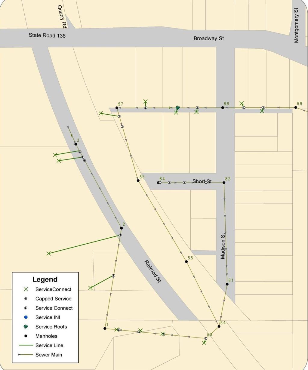
18 Population 862 Owns 20,000 feet of sewer pipes The City of Carlton, MN
.")
19 The City of Carlton, MN One CCTV contract bid and let. Televise/clean complete system (20,000 LF). Database format was spec d.

20 The City of Carlton, MN
21
22
23 The City of Carlton, MN

24 The City of Carlton, MN Collapsed Pipe

25 The City of Carlton, MN Fractures

26 The City of Carlton, MN Cracks
27

28 June 2012 flood. Re-televised entire system as change order to original contract. The City of Carlton, MN

29 The City of Carlton, MN
30 The City of Carlton, MN In-house spot repairs. Remaining pipe defects rehabilitation project. Base bid flood damaged assets. Alternate bids non-flood damaged assets.
31


32 The City of Carlton, MN Rehabilitation Project o Cured in Place Pipe (CIPP Lining) 2,295 L.F. o Grouting lateral connections - 50

33 The City of Carlton, MN
34 Summary The integration of GIS technology adds substantial value to the CCTV process. Process delivers an efficient and complete snapshot of the sewer system with overall ratings of pipelines in an easy to read format. Map format is ideal for presentations to councils and committees. People can understand a picture! Fast and efficient.
35 Summary Reduces review time for staff and/or consultants = cost and time savings. Lateral mapping aids in risk reduction of Digger s Hotline Locates. Owners can build and update their sewer system maps in conjunction with pipeline inspections.
36 Summary CMOM Compliance Tool. Information can easily be converted into bidding documents for future pipeline maintenance and rehab projects as evidenced by the Carlton project. Flexible hard copy maps to mobile applications. Asset management.
37 Conclusion Integrating GIS technology into CCTV inspections provides value and efficiencies. Provides accurate and efficient system and defect mapping and condition assessment. Expedites the review/decision making process. Allows for continuous system map updates and asset management. Aids in bidding documents for pipe rehabilitation projects.


38 Questions? Thank You
STORMWATER ASSET MANAGEMENT:
 STORMWATER ASSET MANAGEMENT: THE ROLE OF GIS IN ASSET MANAGEMENT Janice Lerg, Hubbell, Roth & Clark, Inc. Brian McElroy, Hubbell, Roth & Clark, Inc. Kevin Fowler, Hubbell, Roth & Clark, Inc. IMAGIN CONFERENCE
Sewer Lateral Mapping: An Automated Approach
 Sewer Lateral Mapping: An Automated Approach MSGIC 2016 Fall Quarterly Meeting David Thaler, GISP david.thaler@ebaengineering.com EBA Engineering, Inc. 6100 Chevy Chase Drive Suite 200 Laurel, MD 20707-2917
Inlets to Outlets: You May Be Surprised at What You Find
 Inlets to Outlets: You May Be Surprised at What You Find TFMA Annual Conference March 10, 2016 Presented by Mike Keenum, PE, CFM Jennifer Davidson, PE Steven Nelson, PE, CFM Erin Atkinson, PE, CFM, GISP
MODERNIZATION OF THE MUNICIPAL MAPPING USING HIGH END GNSS SYSTEM AND GIS SOFTWARE
 MODERNIZATION OF THE MUNICIPAL MAPPING USING HIGH END GNSS SYSTEM AND GIS SOFTWARE Mr. R. A. R. Khan Assistant Engineer, Sewerage Utility Management Centre (SUMC) Municipal Corporation Of Greater Mumbai
Clean Water 2020 Program
 Clean Water 2020 Program SEWER MAPPING PROGRAM July 2014 Submitted to EPA SCDHEC July 17, 2014 Table of Contents Program Summary and Intent... 2 Section 1. Sewer Mapping Program Objectives... 5 Section
GIS ENHANCED FIELD DATA COLLECTION FUSION OF LAND SURVEY, GIS MAPPING, AND TRADITIONAL FIELD INSPECTION
 GIS ENHANCED FIELD DATA COLLECTION FUSION OF LAND SURVEY, GIS MAPPING, AND TRADITIONAL FIELD INSPECTION 10/27/2016 ILGISA 2016 1 MORE ABOUT PRESENTER EDUCATIONAL BACKGROUND TECHNICAL SCHOOL OF GEODESY
GIS Implementation for Infrastructure
 GIS Implementation for Infrastructure Maximizing Your Resources A Case Study of the Village of South Elgin Presented by: Andy Zaletel, GISP & Dan Mann June 5, 2012 Providing proven GIS planning strategies
IH 35 at Blanco River May 2015
 IH 35 at Blanco River May 2015 Presentation Objectives Background of historical damage assessment processes Introduction to Collector App ( Mat Peck) Collector App and Flood Damage Assessment (Katie Steele)
Empowering water/wastewater network management with GIS
 Empowering water/wastewater network management with GIS Ioannis Kavouras_GIS Manager Surveying Engineer, MSc, MBA The Company responsible for fresh water distribution & sanitation serving 1.500.000 citizens
How GIS can support the Production
 How GIS can support the Production of Local Development Plans ESRI User Conference 2017 Mandy Maas ARUP Who we are Shaping a better world We are an independent firm of designers, planners, engineers, consultants
GIS Geographical Information Systems. GIS Management
 GIS Geographical Information Systems GIS Management Difficulties on establishing a GIS Funding GIS Determining Project Standards Data Gathering Map Development Recruiting GIS Professionals Educating Staff
Enabling Success in Enterprise Asset Management: Case Study for Developing and Integrating GIS with CMMS for a Large WWTP
 Enabling Success in Enterprise Asset Management: Case Study for Developing and Integrating GIS with CMMS for a Large WWTP Allison Blake, P.E. 1*, Matthew Jalbert, P.E. 2, Julia J. Hunt, P.E. 2, Mazen Kawasmi,
GIS Geographic Information Systems
 GIS Geographic Information Systems Connecting your Community Ruekert Mielke WAUKESHA WHO WE ARE DATE ESTABLISHED 1946 SERVING LOCAL PEOPLE. SOLVING LOCAL PROBLEMS. TYPE OF ORGANIZATION Ruekert & Mielke,
USING GIS IN WATER SUPPLY AND SEWER MODELLING AND MANAGEMENT
 USING GIS IN WATER SUPPLY AND SEWER MODELLING AND MANAGEMENT HENRIETTE TAMAŠAUSKAS*, L.C. LARSEN, O. MARK DHI Water and Environment, Agern Allé 5 2970 Hørsholm, Denmark *Corresponding author, e-mail: htt@dhigroup.com
Ready to Respond: Improving Critical Water Line Locating with SUE and GIS
 Ready to Respond: Improving Critical Water Line Locating with SUE and GIS Matt Wetherell Town of Cary Eric Wilson KCI Technologies Shane Slaughter KCI Technologies Discussion Background Kildaire Farm Rd
GIS. in the City of Lewiston Maine
 GIS in the City of Lewiston Maine The purpose of this slideshow is to provide an overview of the city GIS and how it is used, maintained and accessed in-house as well as by the public. Please simply hit
PRELIMINARY ENGINEERING REPORT FOR SANITARY SEWER COLLECTION SYSTEM OSKALOOSA, IOWA 2017
 PRELIMINARY ENGINEERING REPORT FOR SANITARY SEWER COLLECTION SYSTEM OSKALOOSA, IOWA 2017 PRELIMINARY ENGINEERING REPORT FOR SANITARY SEWER COLLECTION SYSTEM OSKALOOSA, IOWA 2017 I hereby certify that this
ArcGIS for Local Government
 Wednesday, June 29th ArcGIS for Local Government Dan Rose, GIS Analyst WaterOne IT/GIS Agenda / Talking Points What is the LGIM? WaterOne s GIS and LGIM background Our geodatabase redesign Our strategies
Mapping Utilities with Mobile GIS Applications
 Mapping Utilities with Mobile GIS Applications Kristy M. Capobianco Reynolds, Smith and Hills, Inc. GIS Analyst Kristy.Capobianco@rsandh.com (904) 256-2251 2007 ESRI Southeast User Group Conference May
Inflow and Infiltration. John Sorrell, P.E. City of Raleigh Public Utilities Department
 Inflow and Infiltration John Sorrell, P.E. City of Raleigh Public Utilities Department 1 Raleigh s History with I&I Our initial system was designed in 1888. Treatment began in the 1950 s What is I & I?
GIS-Based Sediment Quality Database for the St. Louis River Area of Concern (AOC): Overview Presentations and Demonstration
: Overview Presentations and Demonstration") GIS-Based Sediment Quality Database for the St. Louis River Area of Concern (AOC): Overview Presentations and Demonstration Judy L. Crane 1 and Dawn E. Smorong 2 1 Minnesota Pollution Control Agency, St.
GIS-Based Sediment Quality Database for the St. Louis River Area of Concern (AOC): Overview Presentations and Demonstration Judy L. Crane 1 and Dawn E. Smorong 2 1 Minnesota Pollution Control Agency, St.
Interceptor Surveying and Mapping (ISM) Pre-proposal Meeting
 Pre-proposal Meeting") Pre-proposal Meeting 127 miles of pipes 2,600 manholes Interceptor Surveying and Mapping Southerly District Big Creek Mill Creek Southerly Easterly District Collinwood Hayden Ivanhoe Lakeshore Nottingham
Pre-proposal Meeting 127 miles of pipes 2,600 manholes Interceptor Surveying and Mapping Southerly District Big Creek Mill Creek Southerly Easterly District Collinwood Hayden Ivanhoe Lakeshore Nottingham
MAPPS 2012 Geospatial Products and Services Excellence Awards Awards Entry Form
 MAPPS 2012 Geospatial Products and Services Excellence Awards 2012 Awards Entry Form Please include a copy of this document with the project/product submission Entry Information Submission Number: 1741558
Internal Audit Report
 Internal Audit Report Right of Way Mapping TxDOT Internal Audit Division Objective To determine the efficiency and effectiveness of district mapping procedures. Opinion Based on the audit scope areas reviewed,
T: E:
 PAS 128 UTILITY DETECTION AND MAPPING TOPOGRAPHICAL SURVEYS UTILITY RECORD SEARCHES AND DESK TOP STUDY SURFACE WATER DRAINAGE SURVEYS GROUND CLEARANCE SURVEYS MEASURED BUILDING SURVEYS LASER SCANNING UAV
Managing an Extreme Weather Event of Prolonged Duration May 22, 2013
 Managing an Extreme Weather Event of Prolonged Duration May 22, 2013 MISSOURI RIVER FLOOD OF 2011 M I C H A E L J. K E N N E R L Y P. E. D I R E C T O R O F T H E O F F I C E O F D E S I G N I O W A D
System Mapping Case Studies
 System Mapping Case Studies 1. Madison Getting Started Three Step Approach 2. Rocky Hill Maximizing resources 3. Putman Boots on the ground CT Map Rocky Hill Putnam Madison Madison Community Profile Getting
GEOMATICS SURVEYING AND MAPPING EXPERTS FOR OVER 35 YEARS
 GEOMATICS SURVEYING AND MAPPING EXPERTS FOR OVER 35 YEARS 2 GEOMATICS AND SURVEYING SOLUTIONS SPANNING THE ENTIRE PROJECT LIFECYCLE 1,000+ 250+ 24 Surveying professionals Active field crews Geomatics offices
GIS TECHNICIAN I GIS TECHNICIAN II
 GIS TECHNICIAN I GIS TECHNICIAN II CITY OF ROSEVILLE DEFINITION To perform a variety of technical office and field work duties related to the creation and maintenance of maps, tables, graphs and other
The project, born from an idea of the Provincial College of the Surveyors of Trapani and from the synergy between the administration of Mazara del
 The project, born from an idea of the Provincial College of the Surveyors of Trapani and from the synergy between the administration of Mazara del Vallo, with the Surveyors Professional Organizations :
FINANCE AND PUBLIC WORKS COMMITTEE Wednesday, July 9, 2014 Earl McGovern Board Room, 6:30 P.M
 FINANCE AND PUBLIC WORKS COMMITTEE Wednesday, July 9, 2014 Earl McGovern Board Room, 6:30 P.M PLEASE TAKE NOTICE that a regular meeting will be held before the Finance and Public Works Committee in the
Public Disclosure Copy
 Public Disclosure Authorized MIDDLE EAST AND NORTH AFRICA Iraq Social, Urban, Rural and Resilience Global Practice Global Practice IBRD/IDA Investment Project Financing FY 2016 Seq No: 2 ARCHIVED on 27-May-2016
Rural GIS Applications Geospatial Technology Awareness
 Rural GIS Applications Geospatial Technology Awareness Mike Rudibaugh, Ph.D. Co-PI NSF GeoTech Center Geography/GIS Instructor Lake Land College mrudibau@lakeland.cc.il.us 217-234-5244 What is the GeoTech
Executive Summary Name: Company: Name of Project: Awards Result:
 Executive Summary Name: Dwayne Honor Company: Bundaberg Regional Council Name of Project: Streamlining Workflows The Integration of 12d, 12d Field and GIS Awards Result: Third Place (Tied) For many years
Comparison of core sampling and visual inspection for assessment of sewer pipe condition
 Comparison of core sampling and visual inspection for assessment of sewer pipe condition N. Stanić, C. de Haan, M. Tirion, J. Langeveld and F. Clemens 9 th International Joint IWA/IAHR Conference on Urban
POSITION DESCRIPTION. Position Title: Geographic Information Systems (GIS) Coordinator Department: Engineering
 Coordinator Department: Engineering") POSITION DESCRIPTION Position Title: Geographic Information Systems (GIS) Coordinator Department: Engineering Reports To: Engineering Supervisor FLSA Status: Exempt Date: April 2018 PRIMARY OBJECTIVE OF
POSITION DESCRIPTION Position Title: Geographic Information Systems (GIS) Coordinator Department: Engineering Reports To: Engineering Supervisor FLSA Status: Exempt Date: April 2018 PRIMARY OBJECTIVE OF
GEOGRAPHIC INFORMATION SYSTEM ANALYST I GEOGRAPHIC INFORMATION SYSTEM ANALYST II
 CITY OF ROSEVILLE GEOGRAPHIC INFORMATION SYSTEM ANALYST I GEOGRAPHIC INFORMATION SYSTEM ANALYST II DEFINITION To perform professional level work in Geographic Information Systems (GIS) management and analysis;
Techniques for Science Teachers: Using GIS in Science Classrooms.
 Techniques for Science Teachers: Using GIS in Science Classrooms. After ESRI, 2008 GIS A Geographic Information System A collection of computer hardware, software, and geographic data used together for
Town of Taos Request for Proposal Historic Preservation GIS Geodatabase Project April 2007
 Town of Taos Request for Proposal Historic Preservation GIS Geodatabase Project April 2007 1. Background The Town of Taos is requesting proposals from qualified firms or a team of firms who can develop
ASSESSMENT. Industry Solutions Harness the Power of GIS for Property Assessment
 ASSESSMENT Industry Solutions Harness the Power of GIS for Property Assessment Esri Canada has thousands of customers worldwide who are using the transforming power of GIS technology to collect, maintain,
Information. Information Technology. Geographic. Services (GIS) 119 W Indiana Ave Deland, FL 32720
 119 W Indiana Ave Deland, FL 32720") Information Technology Geographic Information Services (GIS) 119 W Indiana Ave Deland, FL 32720 A GIS consists of 5 primary components: Hardware Software People Data Methods or Business Processes --- Hardware
Information Technology Geographic Information Services (GIS) 119 W Indiana Ave Deland, FL 32720 A GIS consists of 5 primary components: Hardware Software People Data Methods or Business Processes --- Hardware
CITY OF RIVERSIDE USING HAZUS TO CREATE A EARTHQUAKE PLANNING GUIDE FOR A UNIFIED FIELD RESPONSE
 CITY OF RIVERSIDE USING HAZUS TO CREATE A EARTHQUAKE PLANNING GUIDE FOR A UNIFIED FIELD RESPONSE Presented by the Phil McCormick City of Riverside Office of Emergency Management HISTORY The City had several
Extreme Weather Events and Transportation Asset Management
 Extreme Weather Events and Transportation Asset Management AASHTO Annual Meeting November 17, 2012 Mike Savonis ICF International 1 AASHTO commissioned a short paper on how to address Extreme Weather Events
State of Israel Ministry of Housing and Construction Survey of Israel. The Hydrological project case
 State of Israel Ministry of Housing and Construction Survey of Israel The Hydrological project case Survey of Israel Content Introduction To the Survey of Israel The operation assumptions The main responsibilities
Building an Enterprise GIS for Chicago s Water Reclamation District
 Building an Enterprise GIS for Chicago s Water Reclamation District Presenters Presented at the 2010 ESRI User Conference Authored and Presented By Sanjay Patel, PE, CEM, CMRP Metropolitan Water Reclamation
Storm Surge Analysis Update Meeting Cross City, Florida June 17, 2014
 Big Bend Coastal Storm Surge Study Storm Surge Analysis Update Meeting Cross City, Florida June 17, 2014 Introductions Risk MAP Project Team FEMA Region IV Florida Division of Emergency Management (FDEM)
7 GEOMATICS BUSINESS SOLUTIONS - ANNUAL REPORT 2006
 7 GEOMATICS BUSINESS SOLUTIONS - ANNUAL REPORT 2006 The Planning and Economic Development Committee recommends the adoption of the recommendation contained in the following report November 30, 2006, from
McHenry County Property Search Sources of Information
 Disclaimer: The information in this system may contain inaccuracies or typographical errors. The information in this system is a digital representation of information derived from original documents; as
Construction in my Neighborhood - Communication with Stakeholder and Public -
 Construction in my Neighborhood - Communication with Stakeholder and Public - Presented by: Navneet Virk East Bay Municipal Utility District, Oakland, CA 0 Mission at EBMUD To manage the natural resources
AHEAD OF THE STORM: Extreme Weather Resilience in the City of Toronto
 AHEAD OF THE STORM: Extreme Weather Resilience in the City of Toronto David MacLeod Toronto Environment and Energy Office Environmental Applied Science and Management Symposium 2013 March 21, 2013 Ahead
FINANCE AND PUBLIC WORKS COMMITTEE Wednesday, July 8, 2015 Earl McGovern Board Room, 6:30 P.M
 FINANCE AND PUBLIC WORKS COMMITTEE Wednesday, July 8, 2015 Earl McGovern Board Room, 6:30 P.M PLEASE TAKE NOTICE that a regular meeting will be held before the Finance and Public Works Committee in the
Steve Pietersen Office Telephone No
 Steve Pietersen Steve.Pieterson@durban.gov.za Office Telephone No. 031 311 8655 Overview Why geography matters The power of GIS EWS GIS water stats EWS GIS sanitation stats How to build a GIS system EWS
OC Public Works El Niño Storm Preparation 2015
 OC Public Works El Niño Storm Preparation 2015 December 8, 2015 Overview About OC Public Works Storm Preparation Pre-Storm During Storm Post-Storm Storm Preparation Canyon and Burn Areas County Department
Linear Referencing Systems (LRS) Support for Municipal Asset Management Systems
 Support for Municipal Asset Management Systems") Linear Referencing Systems (LRS) Support for Municipal Asset Management Systems Esri Canada Infrastructure Asset Management Leadership Forum November 1, 2017 Toronto, ON David Loukes, P. Eng., FEC Andy
Linear Referencing Systems (LRS) Support for Municipal Asset Management Systems Esri Canada Infrastructure Asset Management Leadership Forum November 1, 2017 Toronto, ON David Loukes, P. Eng., FEC Andy
SECTION DESCRIPTION PAGE I. BUDGET INTRODUCTION... 1 II. FISCAL YEAR 2017 BUDGET ANALYSIS... 2 III. PROPOSED OPERATING BUDGET... 4
 2018 SECTION DESCRIPTION PAGE I. BUDGET INTRODUCTION... 1 II. FISCAL YEAR 2017 BUDGET ANALYSIS... 2 III. PROPOSED OPERATING BUDGET... 4 IV. GENERAL FUND 001 DESCRIPTIONS... 6 V. DEBT SERVICE FUNDS... 9
FIRE DEPARMENT SANTA CLARA COUNTY
 DEFINITION FIRE DEPARMENT SANTA CLARA COUNTY GEOGRAPHIC INFORMATION SYSTEM (GIS) ANALYST Under the direction of the Information Technology Officer, the GIS Analyst provides geo-spatial strategic planning,
GIS Capability Maturity Assessment: How is Your Organization Doing?
 GIS Capability Maturity Assessment: How is Your Organization Doing? Presented by: Bill Johnstone Principal Consultant Spatial Vision Group November 8, 2018 1. Motivation for Capability Maturity Models
KING GEORGE COUNTY DEPARTMENT OF COMMUNITY DEVELOPMENT
 GIS REPORT 2016 KING GEORGE COUNTY DEPARTMENT OF COMMUNITY DEVELOPMENT Background The GIS (Geographic Information System) coordinator was hired in 2001 to develop a GIS for King George County. Prior to
Mapping of Sewerage System of Aurangabad City using GIS Software
 Mapping of Sewerage System of Aurangabad City using GIS Software Amol Adhave, Sachin Bajaj M.Tech Student, Department of CS & IT, Dr.Babasaheb Ambedkar Marathwada University, Aurangabad, Maharashtra, India
Building GIS for Fairfax County Wastewater Management. Gilbert Osei-Kwadwo
 Abstract: Building GIS for Fairfax County Wastewater Management Gilbert Osei-Kwadwo Wastewater Management Agency (WWM) of Fairfax County in Virginia has put a lot of efforts into building an effective
 Boone County GIS has the right to inquire about and investigate the use of any requested products and deny access to anyone based on concerns relating to privacy, security, public health, public safety,
Rebuilding Flood-Conscious Society
 A zone where strong flood flow or river bank erosion by levee breach are anticipated, which likely to occur collapsing/washing away of house. Set up the joint councils by relative stakeholders(river managers,
McHenry County Property Search Sources of Information
 Disclaimer: The information in this system may contain inaccuracies or typographical errors. The information in this system is a digital representation of information derived from original documents; as
JOB TITLE: CURRENT CLASSIFICATION/GRID POSITION # GIS Coordinator AD Grid Level 6(c) # 420
 # 420") COUNTY OF GRANDE PRAIRIE JOB DESCRIPTION JOB TITLE: CURRENT CLASSIFICATION/GRID POSITION # GIS Coordinator AD Grid Level 6(c) # 420 NOC CODE: 2255 STANDARD HOURS: 35 hours/week (non-management) JOB TITLE
COUNTY OF GRANDE PRAIRIE JOB DESCRIPTION JOB TITLE: CURRENT CLASSIFICATION/GRID POSITION # GIS Coordinator AD Grid Level 6(c) # 420 NOC CODE: 2255 STANDARD HOURS: 35 hours/week (non-management) JOB TITLE
National Center for Atmospheric Research Boulder, Colorado Hlllcrest For Further Information: Bill Kroeck, Ext. 36
 28 May 1962 National Center for Atmospheric Research Boulder, Colorado Hlllcrest 3-1960 For Further Information: Bill Kroeck, Ext. 36 FOR IMMEDIATE RELEASE NCAR Scientific Balloon Flight Station to be
Page G Crow Wing County Multi-Hazard Mitigation Plan, 2017
 Table G - 10. s Identified by the () (From Crow Wing County Master Chart) 1 5 All- Hazards All- Hazards Work to ensure that all Crow Wing County residents are aware of and sign-up for the County s Emergency
Geodatabase Replication for Utilities Tom DeWitte Solution Architect ESRI Utilities Team
 Geodatabase Replication for Utilities Tom DeWitte Solution Architect ESRI Utilities Team 1 Common Data Management Issues for Utilities Utilities are a distributed organization with the need to maintain
Timeframe. Crow Wing County, Baxter, Brainerd, Breezy Point, Crosby, Crosslake, Cuyuna, Deerwood, Emily, Fifty
 Table G - 13. s Identified for by the () (From Crow Wing County Master Chart) 1 5 9 All- Hazards All- Hazards Winter Work to ensure that all Crow Wing County residents are aware of and sign-up for the
Asset Management Planning. GIS and Asset Management Integration Readiness Assessment
 Asset Management Planning GIS and Asset Management Integration Readiness Assessment With too little data, you won t be able to make any conclusions that you trust. With loads of data you will find relationships
SEWER FUND BUDGET BYLAW
 SEWER FUND BUDGET BYLAW CITY OF PARKSVILLE 2018-2022 Final Financial Plan Sewer Utility Fund Budget Bylaw Funding Sources 2018 2019 2020 2021 2022 Sewer Parcel Taxes $ 29,300 $ 30,179 $ 31,084 $ 32,016
Introduction to Ohio Landslide Hazard Rating System and Landslide Risk Management. By Prof. Robert Liang
 Introduction to Ohio Landslide Hazard Rating System and Landslide Risk Management By Prof. Robert Liang Background Landslides cause public risk (accident: injury/loss of life). Impact on regional economy
CITY OF HAMILTON. PUBLIC WORKS DEPARTMENT Operations Division
 CITY OF HAMILTON PUBLIC WORKS DEPARTMENT Operations Division TO: Chair and Members Public Works Committee WARD(S) AFFECTED: CITY WIDE COMMITTEE DATE: December 2, 2013 SUBJECT/REPORT NO: Winter Control
Road Ahead: Linear Referencing and UPDM
 Road Ahead: Linear Referencing and UPDM Esri European Petroleum GIS Conference November 7, 2014 Congress Centre, London Your Work Making a Difference ArcGIS Is Evolving Your GIS Is Becoming Part of an
Severe Storm Response Version # 1-0-1
 Severe Storm Response Version # 1-0-1 Weather Warnings Environment Canada issues severe weather warnings, watches and advisories Weather Watch Severe weather may develop. Weather Warning Severe weather
Construction Project Data Management
 Construction Project Data Management Establishing Foundations for an Asset Database Scot Twining Project Activities Supported by GIS Cadastral Mapping Proposed Pipeline Route Selection Right Of Way Acquisition
SHOW ME THE DATA. FEMA Region 6 Community Assistance Visits Findings Collector
 SHOW ME THE DATA FEMA Region 6 Community Assistance Visits Findings Collector Roberto Ramirez, CFM / ASFPM June 4, 2015 Topics of Discussion Overview of CAV Findings Collection project Why a GIS Based
Enhancing Wastewater Utility Mapping and Flow Line Analysis with Geographic Information Systems (GIS)
") Enhancing Wastewater Utility Mapping and Flow Line Analysis with Geographic Information Systems (GIS) Nicole Chiara (Lynch) Peterson Department of Resource Analysis, Saint Mary s University of Minnesota,
Enhancing Wastewater Utility Mapping and Flow Line Analysis with Geographic Information Systems (GIS) Nicole Chiara (Lynch) Peterson Department of Resource Analysis, Saint Mary s University of Minnesota,
OC Enterprise GIS. Kevin Hills, PLS Cameron Smith, GISP. OC Survey
 OC Enterprise GIS Kevin Hills, PLS Cameron Smith, GISP OC Survey Discussion Points Background & Organizational Structure of OCPW Past practices prior to Enterprise Wide GIS License (ELA) Participating
Department Mission: Mandated Services: Department Overview: Successes and Challenges:
 Department: Information Technology FY 2019 Proposed Budget Department Mission: Klamath County Information Technology delivers business services that empower, support and serve all county departments in
Ottumwa Schafer Stadium 8-Lane Track BIDS RECEIVED AT: OTTUMWA COMMUNITY SCHOOL DISTRICT OFFICE 1112 N. VAN BUREN OTTUMWA, IOWA 52501
 REISSUED 10/09/2017 SECTION 001116 ADVERTISEMENT FOR BIDS 1. Sealed bids will be received by Ottumwa Community School District for construction of the following: Ottumwa Schafer Stadium 8-Lane Track Bids
SECTION DESCRIPTION PAGE I. BUDGET INTRODUCTION... 1 II. FISCAL YEAR 2017 BUDGET ANALYSIS... 2 III. FINAL OPERATING BUDGET... 3
 2018 SECTION DESCRIPTION PAGE I. BUDGET INTRODUCTION... 1 II. FISCAL YEAR 2017 BUDGET ANALYSIS... 2 III. FINAL OPERATING BUDGET... 3 IV. GENERAL FUND 001 DESCRIPTIONS... 4 Background Information The Four
What is GIS? Introduction to data. Introduction to data modeling
 What is GIS? Introduction to data Introduction to data modeling 2 A GIS is similar, layering mapped information in a computer to help us view our world as a system A Geographic Information System is a
What s Happening in My Watershed?
 What s Happening in My Watershed? How Implementing a GIS system to Utilize Spatial Data and Digital Collection Techniques can help Solve Watershed Issues. Mindi J. Parsell City of Tulsa Stormwater Quality
Jefferson Parish GIS Hurricane Response Review. From the information given by A.J. Tapie, GIS Manager of Jefferson Parish, the use of
 Neil Dixon and Ryan Ziegelbauer URPL 969 3/10/2006 Jefferson Parish GIS Hurricane Response Review From the information given by A.J. Tapie, GIS Manager of Jefferson Parish, the use of GIS in the Parish
September 2016 New ArcGIS Solutions
 September 2016 New ArcGIS Solutions Hydroelectric https://profservices.maps.arcgis.com/apps/mapjournal/index.html?appid=0ef98f74f8fb4f9da88 1adc521e1c90f Adopta Engage the public in the maintenance and
MARINMAP PROJECTS
 MARINMAP PROJECTS 2013-2014 # Description EST. Cost Lead 1 Road Layer syncing to Base Map $10,000 GeoData Syncronise the ROAD featue class with changes/updates that have been made to the road network in
1. CALL TO ORDER 2. ROLL CALL 3. PLEDGE OF ALLEGIANCE 4. ORAL COMMUNICATIONS (NON-ACTION ITEM) 5. APPROVAL OF AGENDA 6. EWA SEJPA INTEGRATION PROPOSAL
 5. APPROVAL OF AGENDA 6. EWA SEJPA INTEGRATION PROPOSAL") SPECIAL MEETING AGENDA SAN ELIJO JOINT POWERS AUTHORITY (SEJPA) TUESDAY JULY 12, 2016 AT 8:30 AM ENCINA WATER POLLUTION CONTROL FACILITY (EWA) BOARD MEETING ROOM 6200 AVENIDA ENCINAS CARLSBAD, CALIFORNIA
SPECIAL MEETING AGENDA SAN ELIJO JOINT POWERS AUTHORITY (SEJPA) TUESDAY JULY 12, 2016 AT 8:30 AM ENCINA WATER POLLUTION CONTROL FACILITY (EWA) BOARD MEETING ROOM 6200 AVENIDA ENCINAS CARLSBAD, CALIFORNIA
2012 FLOODS AND DEBRIS REMOVAL
 2012 FLOODS AND DEBRIS REMOVAL June 2012 2012 Floods Tuesday, June 19 AFTERNOON Severe thunderstorms roll across much of the Northland, dropping hail and an initial round of heavy rain in many areas, including
Determination of Urban Runoff Using ILLUDAS and GIS
 Texas A&M University Department of Civil Engineering Instructor: Dr. Francisco Olivera CVEN689 Applications of GIS to Civil Engineering Determination of Urban Runoff Using ILLUDAS and GIS Tae Jin Kim 03.
Mapping a Nation in 3D Singapore s Journey. Bryan Chew Registrar of Titles Assistant Chief Executive Singapore Land Authority
 Mapping a Nation in 3D Singapore s Journey Bryan Chew Registrar of Titles Assistant Chief Executive Singapore Land Authority Singapore Size - 719 sq km Population - 5.5 million Density 7,600/sq km Singapore
YORK REGION DISTRICT SCHOOL BOARD. Procedure #NP464.0, Snow/Ice Clearance and Removal
 YORK REGION DISTRICT SCHOOL BOARD Procedure #NP464.0, Snow/Ice Clearance and Removal Application The Snow/Ice Clearance and Removal procedure addresses the practices to be followed with regards to the
Clark Regional Wastewater District
 2016 Clark Regional Wastewater District Infiltration and Inflow Report For Salmon Creek Treatment Plant February 13, 2017 In Compliance with the NPDES Waste Discharge Permit No. WA-002363-9 Special Condition
FY 2018 Ten Year Capital Plan Review Project List
 FY 2018 Ten Year Capital Plan Review Project List Program Category FY2018 FY2019 FY2020 FY2021 FY2022 FY2023 FY2024 FY2025 FY2026 FY2027 Highway Roadway/Safety 100,950,000 128,431,766 125,896,635 91,153,571
2015 NYS Geospatial Applications Awards Competition Entry Form
 2015 NYS Geospatial Applications Awards Competition Entry Form Please use the below template to submit your entry for the 2015 NYS Geospatial Applications Awards Competition. By entering the competition,
Surveyors and GIS Geeks What we need to know. Alyssa Martin, GISP, LEED BD+C AP, Nathan Wysocki
 Surveyors and GIS Geeks What we need to know Alyssa Martin, GISP, LEED BD+C AP, Nathan Wysocki Adversarial Relationship? Some sources Tension between surveying and GIS: A growing challenge Connecting the
Lesson 8: Informally Fitting a Line
 Classwork Example 1: Housing Costs Let s look at some data from one midwestern city that indicates the sizes and sale prices of various houses sold in this city. Size (square feet) Price (dollars) Size
If you aren t familiar with Geographical Information Systems (GIS), you. GIS, when combined with a database that stores response information,
, you. GIS, when combined with a database that stores response information,") Geographical Information Systems in EMS By William E. Ott If you aren t familiar with Geographical Information Systems (GIS), you should take a look at what GIS can offer you as an EMS manager. GIS, when
Geographical Information Systems in EMS By William E. Ott If you aren t familiar with Geographical Information Systems (GIS), you should take a look at what GIS can offer you as an EMS manager. GIS, when
A Summary of State DOT GIS Activities. Presented at the 2000 AASHTO GIS-T Symposium Minneapolis, MN
 A Summary of State DOT GIS Activities Presented at the 2000 AASHTO GIS-T Symposium Minneapolis, MN Information Sources E-mail survey of state DOT GIS managers 49 State DOTs responded in 2000 Results compared
Regional Centre for Mapping of Resources for Development (RCMRD), Nairobi, Kenya
, Nairobi, Kenya") Regional Centre for Mapping of Resources for Development (RCMRD), Nairobi, Kenya Introduction to GIS (2 weeks: 10 days) Intakes: 8 th January, 6 th February, 5th March, 3 rd. April 9 th, May 7 th, June
Regional Centre for Mapping of Resources for Development (RCMRD), Nairobi, Kenya Introduction to GIS (2 weeks: 10 days) Intakes: 8 th January, 6 th February, 5th March, 3 rd. April 9 th, May 7 th, June
CHAPTER 22 GEOGRAPHIC INFORMATION SYSTEMS
 CHAPTER 22 GEOGRAPHIC INFORMATION SYSTEMS PURPOSE: This chapter establishes the administration and use of to improve the quality and accessibility of Department s spatial information and support graphical