Implementing a Spatial Decision Support System for Puerto Rico: The Political Process
|
|
|
- Merilyn Singleton
- 5 years ago
- Views:
Transcription

1 Implementing a Spatial Decision Support System for Puerto Rico: The Political Process Brugge,, Belgium April 2008 Guy Engelen and Elías R. Gutiérrez, Ph.D. VITO - Flemish Institute for Technological Research Centre for Integrated Environmental Studies Boeretang 200, 2400 Mol, Belgium guy.engelen@vito.be Graduate School of Planning, UPR Rio Piedras, Puerto Rico eliasgutierrez@yahoo.com
2 Puerto Rico: Some Key Facts Puerto Rico is a densely populated Caribbean archipelago that transformed itself in 50 years from a very poor rural to an industrial urbanized society. Industrialization was a relatively successful strategy to lift the island from poverty. Urbanization and land use has been a planning failure.

3 Puerto Rico s Dominant Land Use Pattern

4 Indicators of Environmental Stress
5 What is Xplorah A state of the arts SDSS tailor-made for the Integrated Assessment of Socio-economic and Environmental Spatial Policies. With simulation capabilities that produce future likely land-use patterns consistent with userdefined scenarios developing into the future. A tool to support strategic thinking and evaluation of alternative policies under different sets of circumstances.
6 Objectives and State of the Art Xplorah was planned to evolve into a SDSS for the Integrated Assessment of Socio-economic and Environmental Spatial Policies: Autonomous developments (dynamics) of the system; Current and future effects of policies; Evaluation of alternative policies.
7 The Development Process The GSP commissioned the development of Xplorah to RIKS in 2001 with support from: The Office of the President of the University of Puerto Rico; and Public Policy Research Center of the Rafael Hernández Colón Foundation (RHCF); First prototype available March 2002;
8 Xplorah s Building Blocks The core element is the Constrained Cellular Automata model of White, Engelen and Uljee, representing the Puerto Rican archipelago at 4 geographical levels: 3 Islands 78 Municipios 100 Transport Zones and 225,000 Cellular Entities of 6.25ha each. Demographic and economic systems integrated by means of linked dynamic models that jointly determine land use patterns over time.
9 Resistance met: Development and implementation of the Xplorah SDSS met resistance at the institutional level reflecting: The political nature of land use policies. The very limited role traditionally played by sophisticated tools for policy making and planning.
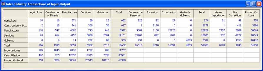
10 Strategy Followed to Gain Support From Potential Users Integrate existing models being used in uncoupled and unrelated modes, with new models of special interest: Demographic Input-output Macroeconomic and sector Housing supply / demand Transportation Climate
11 Major Enhancements Linked to Land Use Make Xplorah Unique An age-cohort demographic model; Macroeconomic model (39 equations) Final Demand and Housing Forecaster Input-output Matrix (92 sectors); A 4 stage transportation model; Regional models that distribute national aggregates; A Cellular Automata Land Use Model acting at the local level

12 The User Interface Illustrates Processes at 4 Strongly Coupled Spatial Levels


13 National Economics & Demographics

14 The Four Stage Model Jobs & Population Cost matrix Land use Production & Attraction Distribution & Modal split Departures & Arrivals Trip Matrix Trip cost & Accessibility Route choice & Allocation Road track Intensities

15 The political dimension is incorporated through: Suitability & Zoning restriction maps (PUT)


16 Xplorah: Processes at 4 strongly coupled spatial levels National 1 Nation Regional 78 Municipios 401 Transport zones Local: cells (250 m)


17 Exploring planning options National Indicators Population, Economic activity, Job indicators Job Potential Scenarios External shocks Alternative visions Ex-post, ex-ante trends Municipal Indicators Population, Economic activity, Job indicators Transportation Indicators Accessibility, Population, Jobs, Traffic, indicators Potential biodiversity Local Indicators Land use, Environmental, Economic, and Social indicators Actual and optional policies
18 The Political Process An Intensive effort to obtain acceptance and public funding necessary for development and implementation was launched from the start After a dozen depositions to House and Senate Committees
19 First Major Success On February 2003, a Joint Resolution, approved unanimously by the House of Representatives and the Senate, was signed into law by then Governor Sila María Calderón to partially fund and support the development of Xplorah.
20 The Stumbling Rock The House and Senate unanimously voted R.C. de la C to extend funding for Xplorah s development, but; Separately, order the Puerto Rico Planning Board (PRPB) to prepare a land use plan (PUT) with no funding! Xplorah and the PUT became competing projects!


21 Then the Tragedy! R.C. de la C is Vetoed!
22 So start again!
23 In the mean time the politics of land use intensified The absence and need for an SDSS became clear. The technical and political process came to a boiling point in 2006 with the publication by the PRPB of a draft of the first land use plan (PUT) ever attempted for the island.
24 Pandemonium! The PUT was found to be based on Inaccurate, outdated and incorrect land use maps; The PRPB lacked instruments to evaluate alternatives; The likely consequences of plan adoption were unknown; The team of planners and technicians that had prepared the plan revolted and were dismissed.
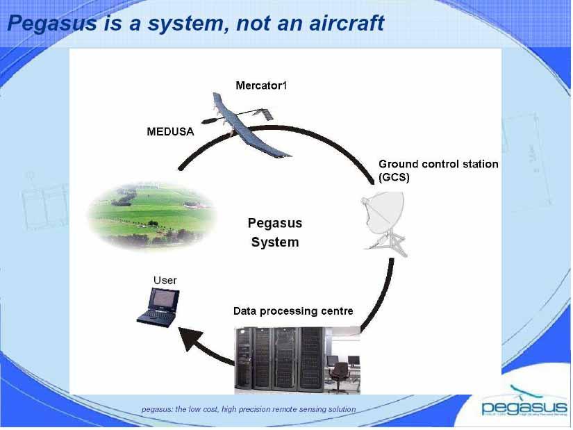
25
26 A technical problem transformed into a political time bomb. Need for Xplorah Gains Political Support!
27 An Updated Land Use Map Become a Political Necessity The Need for Xplorah Gained Political Support!
28 Enter the The Governor s Advisory Board on Urbanism to plan, Xplorah is needed, and Xplorah requires reliable data

29
30 Puerto Rico needs a plan but, how can we plan if you don t even know what s on the ground?

31 Then, fiscal crisis strikes: On May 1st 2006 the government of the Commonwealth of Puerto Rico shuts down for the first time in history after running out of cash to pay the wage bill.

32 Implementing Xplorah requires production of adequate land use maps at affordable cost An Unexpected Technological Solution Enters the Arena


33 Pegasus: UAV-HALE Remote Sensing Platform
34
35 The Inevitable Result
36 But, wait

37 There was a joker in the deck!
38 Politics again In December 2006 the New Progressive Party (NPP) that controls the Legislature, blocked a $500 million GO bond issue that, among other infrastructure projects, would have funded the implementation of Xplorah. The battle was afoot once more!
39 Finally In December 2007 the contracts were signed and the project s implementation starting in January 2008 and programmed to extend for 30 months.
40 THE END?
Supporting Strategic Plan Development in Flanders
 Supporting Strategic Plan Development in Flanders Guy Engelen, Inge Uljee, Anne Gobin, Leen Van Esch, Hans van der Kwast VITO Flemish Institute for Technological Research Boeretang 200 2400 Mol Belgium
Implementation of the ESPON 2020 cooperation program. 16 January 2017 Anneloes van Noordt
 Implementation of the ESPON 2020 cooperation program 16 January 2017 Anneloes van Noordt Outline! ESPON Cooperation Program! Specific Objectives! Applied Research! Targeted Analysis! Database & Tools!
Public Disclosure Copy
 Public Disclosure Authorized EAST ASIA AND PACIFIC Vanuatu Social, Urban, Rural and Resilience Global Practice Global Practice Recipient Executed Activities Technical Assistance Loan FY 2013 Seq No: 7
TOWARDS STRATEGIC SPATIAL PLANNING IN JAMAICA: THE NATIONAL SPATIAL PLAN
 TOWARDS STRATEGIC SPATIAL PLANNING IN JAMAICA: THE NATIONAL SPATIAL PLAN JIEP 5th Biennial Conference on the Environment: Balancing National Development and Environmental Protection June 6, 2011 Jamaica
METRONAMICA: A dynamic spatial land use model applied to Vitoria-Gasteiz
 METRONAMICA: A dynamic spatial land use model applied to Vitoria-Gasteiz Hedwig van Delden 1, Juan Carlos Escudero 2, Inge Uljee 1 and Guy Engelen 1,3 1 Research Institute for Knowledge Systems (RIKS)
Facts and Findings. Exhibit A-1
 Exhibit A-1 Facts and Findings The county periodically prepares coordinated countywide forecasts for all the cities in the county and the unincorporated area. These forecasts can be used by cities as a
Land Use in the context of sustainable, smart and inclusive growth
 Land Use in the context of sustainable, smart and inclusive growth François Salgé Ministry of sustainable development France facilitator EUROGI vice president AFIGéO board member 1 Introduction e-content+
Third Cohesion report February 2004
 February 2004 A new partnership for cohesion Convergence, Competitiveness and Co-operation METREX meeting S. Sebastian, Luisa Sanches DG REGIO The 3rd CR structure 1. Analysis of situation and trends in
Date: March 31, 2014 PATE; fyril 2.3,2 >H
 aj BRAMPTON fifs Rower City XH-l-f r.t "»* City Council The Corporation of the City of Brampton SRAMPTON CITY COUNCIL Date: March 31, 2014 PATE; fyril 2.3,2 >H File: POO GR VisWhtoJed ^t'th-meeh'^a Subject:
OREGON POPULATION FORECAST PROGRAM
 OREGON POPULATION FORECAST PROGRAM PROGRAM OVERVIEW BACKGROUND Beginning in 1973 with the passage of Senate Bill (SB) 100, Oregon s growth management system has relied on population forecasts as the primary
Task A4, Appendix A: Maryland Land Use and Impact Assessment Model
 Task A4, Appendix A: Maryland Land Use and Impact Assessment Model The LEAM Model During the last two decades, spatial analysis tools, geographic information systems (GIS), and remote-sensing (RS) technologies
Weather Climate Science to Service Partnership South Africa
 PROJECTS UNDERWAY Title of the Weather Climate Science to Service Partnership South Africa Together, building on an existing strong partnership, South African Weather Service and the Met Office will build
The National Spatial Strategy
 Purpose of this Consultation Paper This paper seeks the views of a wide range of bodies, interests and members of the public on the issues which the National Spatial Strategy should address. These views
City of Jerez Urban Core Densification proposal; An Agent Based Spatio-temporal model
 Modelling urban population allocation City of Jerez Urban Core Densification proposal; An Agent Based Spatio-temporal model Elke Sauter Julia Úbeda Who we are & why we are here Masters programme: Geographical
ESPON 2020 Cooperation Programme. Anneloes van Noordt MC-member Belgium
 ESPON 2020 Cooperation Programme Anneloes van Noordt MC-member Belgium Anneloes.vannoordt@vlaanderen.be Outline ESPON 2020 Cooperation Programme Applied Research Targeted Analysis Database & Tools Outreach
A Simplified Travel Demand Modeling Framework: in the Context of a Developing Country City
 A Simplified Travel Demand Modeling Framework: in the Context of a Developing Country City Samiul Hasan Ph.D. student, Department of Civil and Environmental Engineering, Massachusetts Institute of Technology,
Seq No: 8 ARCHIVED on 21-May-2018 ISR30720 Created by: Raghava Neti on 04-Dec-2017 Modified by: Raghava Neti on 08-May-2018
 Public Disclosure Authorized SOUTH ASIA India Water Global Practice Requesting Unit: SACIN Responsible Unit: GWA06 IBRD/IDA Program-for-Results FY 2014 Team Leader(s): Raghava Neti Seq No: 8 ARCHIVED on
The Governance of Land Use
 The planning system The Governance of Land Use United Kingdom Levels of government and their responsibilities The United Kingdom is a unitary state with three devolved governments in Northern Ireland,
BROADBAND DEMAND AGGREGATION: PLANNING BROADBAND IN RURAL NORTHERN CALIFORNIA
 BROADBAND DEMAND AGGREGATION: PLANNING BROADBAND IN RURAL NORTHERN CALIFORNIA Steven J. Steinberg, Ph.D a,b, *, Rebecca Degagne a, M.S., Michael Gough a a Institute for Spatial Analysis, Humboldt State
Development of modal split modeling for Chennai
 IJMTES International Journal of Modern Trends in Engineering and Science ISSN: 8- Development of modal split modeling for Chennai Mr.S.Loganayagan Dr.G.Umadevi (Department of Civil Engineering, Bannari
Committee Meeting November 6, 2018
 Committee Meeting November 6, 2018 Agenda Where we are in the process Land Use Plan Transportation Element Housing & Neighborhoods Elements Next Steps Schedule November 6: Plan Elements December: Plan
Population and Employment Forecast
 Population and Employment Forecast How Do We Get the Numbers? Thurston Regional Planning Council Technical Brief Updated July 2012 We plan for forecast growth in Population and Employment, but where do
Accessibility as an Instrument in Planning Practice. Derek Halden DHC 2 Dean Path, Edinburgh EH4 3BA
 Accessibility as an Instrument in Planning Practice Derek Halden DHC 2 Dean Path, Edinburgh EH4 3BA derek.halden@dhc1.co.uk www.dhc1.co.uk Theory to practice a starting point Shared goals for access to
Conference on Urban Development Strategies in the Mediterranean Barcelona, March 14-15, 2011
 Analysing Urban Development Strategies: the OECD Approach by Adam Knelman Ostry Counsellor, Regional Development Policy adam.ostry@oecd.org Conference on Urban Development Strategies in the Mediterranean
SPIMA Spatial dynamics and strategic planning in metropolitan areas
 Targeted Analysis SPIMA Spatial dynamics and strategic planning in metropolitan areas Executive Summary Conference version 1 February 2018 0 1. Background To address the challenges of metropolitan development
National observation system Romanian experience
 National observation system Romanian experience ESPON Seminar Monitoring Territorial Dynamics Luxemburg, 12 November 2008 Radu Necşuliu, Ministry of Development, Public Works and Housing What do we want?
Date: June 19, 2013 Meeting Date: July 5, Consideration of the City of Vancouver s Regional Context Statement
 Section E 1.5 To: From: Regional Planning and Agriculture Committee Lee-Ann Garnett, Senior Regional Planner Planning, Policy and Environment Department Date: June 19, 2013 Meeting Date: July 5, 2013 Subject:
Regional Growth Strategy Regional Staff Committee
 Regional Growth Strategy Regional Staff Committee June 21, 2018 1 Overview Summary of June Growth Management Policy Board Regional Growth Strategy Objectives Regional Geographies Regional Growth Strategy
A cellular automata model for the study of small-size urban areas
 Context and Motivation A cellular automata model for the study of small-size urban areas Centre de Política de Sòl i Valoracions Barcelona 23 January 2007 Nuno Norte Pinto School of Technology and Management
The Future of Met Council Forecasts
 The Future of Met Council Forecasts Todd Graham todd.graham@metc.state.mn.us Dennis Farmer dennis.farmer@metc.state.mn.us Metropolitan Council Research Today s Agenda Why we forecast, how we use forecasts
Why care about metropolitan and regional perspectives?
 Metropolitan challenges and solutions Why care about metropolitan and regional perspectives? Irma Karjalainen, Director, Helsinki Region Environmental Services Authority HSY, LUMAT Conference, 25 September
Changes in the Spatial Distribution of Mobile Source Emissions due to the Interactions between Land-use and Regional Transportation Systems
 Changes in the Spatial Distribution of Mobile Source Emissions due to the Interactions between Land-use and Regional Transportation Systems A Framework for Analysis Urban Transportation Center University
Social Studies Grade 2 - Building a Society
 Social Studies Grade 2 - Building a Society Description The second grade curriculum provides students with a broad view of the political units around them, specifically their town, state, and country.
StanCOG Transportation Model Program. General Summary
 StanCOG Transportation Model Program Adopted By the StanCOG Policy Board March 17, 2010 What are Transportation Models? General Summary Transportation Models are technical planning and decision support
The Governance of Land Use
 The planning system Levels of government and their responsibilities The Governance of Land Use COUNTRY FACT SHEET NORWAY Norway is a unitary state with three levels of government; the national level, 19
Country Report On Sdi Activities In Singapore ( )
") UNITED NATIONS E/CONF.102/IP.4 ECONOMIC AND SOCIAL COUNCIL Nineteenth United Nations Regional Cartographic Conference for Asia and the Pacific Bangkok, 29 October 1 November 2012 Item 6(b) of the provisional
UNITED NATIONS E/CONF.102/IP.4 ECONOMIC AND SOCIAL COUNCIL Nineteenth United Nations Regional Cartographic Conference for Asia and the Pacific Bangkok, 29 October 1 November 2012 Item 6(b) of the provisional
Introduction to VITO
 Introduction to VITO RTO cf. IMEC, VIB, IBBT, TNO, Fraunhofer, VTT, Complementary to universities and industry R&D Research organisation Independent Customer oriented Flemish government is sole shareholder
Vincent Goodstadt. Head of European Affairs METREX European Network
 Vincent Goodstadt Head of European Affairs METREX European Network METREX (Network of 50 European Metropolitan Regions and Areas ) Exchanging Knowledge (e.g. Benchmarking) Climate Change CO2/80/50 Expertise
reviewed paper Toward Sustainable Development in Cities: A Case for New Spatial Decision Support Methods in Urban Planning Anna Kaczorowska-Fudala
 reviewed paper Toward Sustainable Development in Cities: A Case for New Spatial Decision Support Methods in Urban Planning Anna Kaczorowska-Fudala (Anna Kaczorowska-Fudala, Gdansk University of Technology,
Economic and Social Council
 United Nations Economic and Social Council Distr.: General 18 July 2016 Original: English Committee of Experts on Global Geospatial Information Management Sixth session New York, 3-5 August 2016 Item 2
Introduction and Project Overview
 Greater New Orleans Regional Land Use Modeling GIS Techniques in a P olitical C ontext Louisiana Remote Sensing and GIS Workshop Wednesday, April 24, 2013 Working Towards a Shared Regional Vision Introduction
Subject: Note on spatial issues in Urban South Africa From: Alain Bertaud Date: Oct 7, A. Spatial issues
 Page 1 of 6 Subject: Note on spatial issues in Urban South Africa From: Alain Bertaud Date: Oct 7, 2009 A. Spatial issues 1. Spatial issues and the South African economy Spatial concentration of economic
SPLAN-Natura Towards an integrated spatial planning approach for Natura th January, 2017 Brussels. Commissioned by DG Environment
 SPLAN-Natura 2000 Towards an integrated spatial planning approach for Natura 2000 Commissioned by DG Environment 17 th January, 2017 Brussels V. Simeonova (Ph.D.) Drivers towards integrating Biodiversity
PLUTO The Transport Response to the National Planning Framework. Dr. Aoife O Grady Department of Transport, Tourism and Sport
 PLUTO 2040 The Transport Response to the National Planning Framework Dr. Aoife O Grady Department of Transport, Tourism and Sport Dublin Economics Workshop 15 th September 2018 The Story of Pluto National
Council Workshop on Neighbourhoods Thursday, October 4 th, :00 to 4:00 p.m. Burlington Performing Arts Centre
 Council Workshop on Neighbourhoods Thursday, October 4 th, 2012 1:00 to 4:00 p.m. Burlington Performing Arts Centre Agenda Introductions Warm-Up Exercise Presentation Exercise Neighbourhood Planning Break
THE ROLE OF REGIONAL SPATIAL PLANNING IN SUPPORTING LONG-TERM ECONOMIC GROWTH IN NORTHERN IRELAND
 THE ROLE OF REGIONAL SPATIAL PLANNING IN SUPPORTING LONG-TERM ECONOMIC GROWTH IN NORTHERN IRELAND Jenny Pyper Director 6 th Annual ICLRD Conference 20 January 2011 PURPOSE OF REGIONAL PLANNING Framework
The European territory: Strategic developmentd
 The European territory: Strategic developmentd Peter Mehlbye Workshop Strategic Development Catalonia 11 June 2002 THE LECTURE Structure I. Territorial trends II. Strategy for European spatial development
INTRODUCING THE EUROPEAN DIMENSION
 INTRODUCING THE EUROPEAN DIMENSION OF DANISH PLANNING ESPON/ENECON POSTGRADUATE WORKSHOP TERRITORIAL GOVERNANCE AND COOPERATION UNIVERSITY OF EASTERN FINLAND JOENSUU, FINLAND OCTOBER 19, 2012 DANIEL GALLAND
GEOGRAPHIC INFORMATION SYSTEMS Session 8
 GEOGRAPHIC INFORMATION SYSTEMS Session 8 Introduction Geography underpins all activities associated with a census Census geography is essential to plan and manage fieldwork as well as to report results
GOVERNMENT MAPPING WORKSHOP RECOVER Edmonton s Urban Wellness Plan Mapping Workshop December 4, 2017
 GOVERNMENT MAPPING WORKSHOP 12.4.17 RECOVER Edmonton s Urban Wellness Plan Mapping Workshop December 4, 2017 In July of 2017, City Council directed administration to develop RECOVER, Edmonton s Urban Wellness
PURR: POTENTIAL OF RURAL REGIONS UK ESPON WORKSHOP Newcastle 23 rd November Neil Adams
 PURR: POTENTIAL OF RURAL REGIONS UK ESPON WORKSHOP Newcastle 23 rd November 2012 Neil Adams PURR: Potential of Rural Regions Introduction Context for the project A spectrum of knowledge Rural Potentials
AMS E-GOS Local governance and performance of open data policies at municipal level
 AMS E-GOS Local governance and performance of open data policies at municipal level Frederika Welle Donker Knowledge Centre Open Data TU Delft f.m.welledonker@tudelft.nl 1 Knowledge Centre Open Data Research
The Tyndall Cities Integrated Assessment Framework
 The Tyndall Cities Integrated Assessment Framework Alistair Ford 1, Stuart Barr 1, Richard Dawson 1, Jim Hall 2, Michael Batty 3 1 School of Civil Engineering & Geosciences and Centre for Earth Systems
Appropriation Directions for 2007
 INSPIRE in Sweden An Important Part of the National Geodata Strategy Monica Lagerqvist Nilsson Appropriation Directions for 2007 A commission to investigate the necessity to adjust the Swedish legislation
Launch of the ESPON 2013 Programme. European observation network on territorial development and cohesion
 Launch of the ESPON 2013 Programme European observation network on territorial development and cohesion Framework conditions for the ESPON 2013 Programme Policy development in use of territorial evidence
The World Bank. Key Dates. Project Development Objectives. Components. Public Disclosure Authorized. Implementation Status & Results Report
 Public Disclosure Authorized EAST ASIA AND PACIFIC Vietnam Transport & ICT Global Practice IBRD/IDA Specific Investment Loan FY 2008 Seq No: 16 ARCHIVED on 28-Dec-2016 ISR26429 Implementing Agencies: Hanoi
Cities and Climate Change (P123201)
") Public Disclosure Authorized AFRICA Mozambique Social, Urban, Rural and Resilience Global Practice Global Practice IBRD/IDA Investment Project Financing FY 2012 Seq No: 14 ARCHIVED on 04-Nov-2018 ISR33750
Public Disclosure Authorized AFRICA Mozambique Social, Urban, Rural and Resilience Global Practice Global Practice IBRD/IDA Investment Project Financing FY 2012 Seq No: 14 ARCHIVED on 04-Nov-2018 ISR33750
GIS Geographical Information Systems. GIS Management
 GIS Geographical Information Systems GIS Management Difficulties on establishing a GIS Funding GIS Determining Project Standards Data Gathering Map Development Recruiting GIS Professionals Educating Staff
2 nd Semester. Core Courses. C 2.1 City and Metropolitan Planning. Module 1: Urban Structure and Growth Implications
 2 nd Semester Core Courses C 2.1 City and Metropolitan Planning Module 1: Urban Structure and Growth Implications Growth of cities; cities as engine of growth; urban sprawl; land value, economic attributes
The World Bank Mali Reconstruction and Economic Recovery (P144442)
") Public Disclosure Authorized AFRICA Mali Social, Urban, Rural and Resilience Global Practice Global Practice IBRD/IDA Emergency Recovery Loan FY 2014 Seq No: 7 ARCHIVED on 30-Jun-2017 ISR28723 Implementing
Public Disclosure Authorized AFRICA Mali Social, Urban, Rural and Resilience Global Practice Global Practice IBRD/IDA Emergency Recovery Loan FY 2014 Seq No: 7 ARCHIVED on 30-Jun-2017 ISR28723 Implementing
Coastal Inundation Forecasting Demonstration Project CIFDP. Flood Forecasting Initiative-Advisory Group (FFI-AG 3), Geneva, 5-7 Dec, 2017
, Geneva, 5-7 Dec, 2017") Coastal Inundation Forecasting Demonstration Project CIFDP Flood Forecasting Initiative-Advisory Group (FFI-AG 3), Geneva, 5-7 Dec, 2017 Coastal Flooding & Vulnerable Populations Coastal populations are
Coastal Inundation Forecasting Demonstration Project CIFDP Flood Forecasting Initiative-Advisory Group (FFI-AG 3), Geneva, 5-7 Dec, 2017 Coastal Flooding & Vulnerable Populations Coastal populations are
CHAPTER 4 HIGH LEVEL SPATIAL DEVELOPMENT FRAMEWORK (SDF) Page 95
 Page 95") CHAPTER 4 HIGH LEVEL SPATIAL DEVELOPMENT FRAMEWORK (SDF) Page 95 CHAPTER 4 HIGH LEVEL SPATIAL DEVELOPMENT FRAMEWORK 4.1 INTRODUCTION This chapter provides a high level overview of George Municipality s
CHAPTER 4 HIGH LEVEL SPATIAL DEVELOPMENT FRAMEWORK (SDF) Page 95 CHAPTER 4 HIGH LEVEL SPATIAL DEVELOPMENT FRAMEWORK 4.1 INTRODUCTION This chapter provides a high level overview of George Municipality s
The World Bank Decentralized Community Driven Services Project (P117764)
") Public Disclosure Authorized AFRICA Benin Social Protection Global Practice IBRD/IDA Adaptable Program Loan FY 2012 Seq No: 6 ARCHIVED on 12-Jun-2015 ISR19748 Implementing Agencies: Public Disclosure Authorized
Public Disclosure Authorized AFRICA Benin Social Protection Global Practice IBRD/IDA Adaptable Program Loan FY 2012 Seq No: 6 ARCHIVED on 12-Jun-2015 ISR19748 Implementing Agencies: Public Disclosure Authorized
The National Policy Strategy for Infrastructure and Spatial Planning CODE24 CONFERENCE. Emiel Reiding
 The National Policy Strategy for Infrastructure and Spatial Planning Emiel Reiding Structure of presentation 1. Spatial planning in the Netherlands 2. National Policy Strategy Aims National interests 3.
A science-policy approach towards local adaptation planning: The case of Santiago de Chile
 A science-policy approach towards local adaptation planning: The case of Santiago de Chile Kerstin Krellenberg, PhD Resilient Cities 2011 2nd World Congress on Cities and Adaptation to Climate Change Bonn,
National Land Use Policy and National Integrated Planning Framework for Land Resource Development
 Title National Land Use Policy and National Integrated Planning Framework for Land Resource Development Duration: 32 Weeks Objective: Adoption of appropriate land use planning approaches to: Maintain the
State GIS Officer/GIS Data
 State GIS Officer/GIS Data This Act creates the position of state Geographic Information Systems (GIS) officer. The Act: requires the state GIS officer to adopt or veto the GIS data standards and a statewide
Frontier and Remote (FAR) Area Codes: A Preliminary View of Upcoming Changes John Cromartie Economic Research Service, USDA
 Area Codes: A Preliminary View of Upcoming Changes John Cromartie Economic Research Service, USDA") National Center for Frontier Communities webinar, January 27, 2015 Frontier and Remote (FAR) Area Codes: A Preliminary View of Upcoming Changes John Cromartie Economic Research Service, USDA The views
National Center for Frontier Communities webinar, January 27, 2015 Frontier and Remote (FAR) Area Codes: A Preliminary View of Upcoming Changes John Cromartie Economic Research Service, USDA The views
Geospatial Enabling Resilient Development. Latin America Geospatial Forum Río de Janeiro September 2013
 Geospatial Enabling Resilient Development Latin America Geospatial Forum Río de Janeiro September 2013 Presentation Index INEGI /SNIEG Geostatistical Frame - Georeferenciation Issues Legal Framework Mexican
Key Elements of the Geographical Information System of Mexico *
 UNITED NATIONS E/CONF.99/IP.1 ECONOMIC AND SOCIAL COUNCIL Ninth United Nations Regional Cartographic Conference for the Americas New York, 10-14 August 2009 Item 7(a) of the provisional agenda Strategy,
Metrolinx Transit Accessibility/Connectivity Toolkit
 Metrolinx Transit Accessibility/Connectivity Toolkit Christopher Livett, MSc Transportation Planning Analyst Research and Planning Analytics Tweet about this presentation #TransitGIS OUTLINE 1. Who is
City and SUMP of Ravenna
 City and SUMP of Ravenna Nicola Scanferla Head of Mobility Planning Unit, Municipality of Ravenna nscanferla@comune.ra.it place your logo here 19 April, 2017 1st Steering Committee Meeting, Nicosia, Cyprus
The World Bank Cities and Climate Change (P123201)
") Public Disclosure Authorized AFRICA Mozambique Social, Urban, Rural and Resilience Global Practice Global Practice IBRD/IDA Investment Project Financing FY 2012 Seq No: 13 ARCHIVED on 17-May-2018 ISR31517
Public Disclosure Authorized AFRICA Mozambique Social, Urban, Rural and Resilience Global Practice Global Practice IBRD/IDA Investment Project Financing FY 2012 Seq No: 13 ARCHIVED on 17-May-2018 ISR31517
Paul Bridge Meteorologist Vaisala/UKMO Work Groups/Committees: WMO/TRB/AMS
 Paul Bridge Meteorologist Vaisala/UKMO Work Groups/Committees: WMO/TRB/AMS Introduction (a) Identify and establish, if possible, inventories of transport networks in the ECE region which are vulnerable
Christina Karaberi- Msc Health Management European Program Manager ITR. CityMobil2 Reference Group Meeting, Antibes, France 22/03/206
 TRIKALA DEMONSTRATION TITLE A CTS SITE- FOR Large THE Scale PerspectiveNEW ROME EXHIBITION Christina Karaberi- Msc Health Management European Program Manager E-Trikala Gabriele S.A Giustiniani, ITR 22/03/206
REGIONAL TRANSIT AUTHORITY. RTA TaskForce. John G. Johnson, Executive Director Association of Central Oklahoma Governments
 REGIONAL TRANSIT AUTHORITY TaskForce John G. Johnson, Executive Director Association of Central Oklahoma Governments February 17, 2016 RECAP on the RTD Boundary Scenarios RECAP REGIONAL TRANSIT DIALOGUE
Stepping away from trend analyses for regional integrated planning and modelling
 University of Wollongong Research Online SMART Infrastructure Facility - Papers Faculty of Engineering and Information Sciences 2015 Stepping away from trend analyses for regional integrated planning and
Global Challenges - Partnering with Service Providers. World Meteorological Organization. J. Lengoasa WMO Deputy Secretary-General
 WMO World Meteorological Organization Working together in weather, climate and water Global Challenges - Partnering with Service Providers J. Lengoasa WMO Deputy Secretary-General jlengoasa@wmo.int http://www.wmo.int/pages/gfcs/gfcs_en.html
The World Bank Haiti Business Development and Investment Project (P123974)
") Public Disclosure Authorized LATIN AMERICA AND CARIBBEAN Haiti Trade & Competitiveness Global Practice IBRD/IDA Specific Investment Loan FY 2013 Seq No: 9 ARCHIVED on 29-Dec-2016 ISR26542 Implementing
Public Disclosure Authorized LATIN AMERICA AND CARIBBEAN Haiti Trade & Competitiveness Global Practice IBRD/IDA Specific Investment Loan FY 2013 Seq No: 9 ARCHIVED on 29-Dec-2016 ISR26542 Implementing
ADDRESSING TITLE VI AND ENVIRONMENTAL JUSTICE IN LONG-RANGE TRANSPORTATION PLANS
 ADDRESSING TITLE VI AND ENVIRONMENTAL JUSTICE IN LONG-RANGE TRANSPORTATION PLANS Activities from the National Capital Region Transportation Planning Board Sergio Ritacco Transportation Planner 2017 Association
The Census, Urbanized Areas, and Your MPO/RPO
 The Census, Urbanized Areas, and Your MPO/RPO Alex Bond, AICP NADO Rural Transportation Peer Learning Conference August 25, 2011 1 Issues to Discuss Census background Definitions of Census geographies
Economic Development and Transport in New Zealand. Thomas Simonson 4/7/2016
 Economic Development and Transport in New Zealand Thomas Simonson 4/7/2016 Definitions > Economics is about people and communities, and the skills, equipment and resources they acquire to pursue their
Spatial Decision Support Systems for policy support in urban planning contexts
 Spatial Decision Support Systems for policy support in urban planning contexts Roel Vanhout P.O. Box 463 6200 AL Maastricht The Netherlands www.riks.nl About RIKS w Independent research institute w Founded
How GIS based Visualizations Support Land Use and Transportation Modeling
 How GIS based Visualizations Support Land Use and Transportation Modeling ESRI International Users Conference San Diego, CA - July 23, 2015 Prepared by: Troy Hightower Introduction This presentation will
Floods 2014 a wake up call to natural hazards
 Floods 2014 a wake up call to natural hazards Floods affected 119 municipalities (out of 165) 22% of total population affected by floods More than 30 municipalities sustained extensive damage 57 lives
Population Research Center (PRC) Oregon Population Forecast Program
 Oregon Population Forecast Program") Population Research Center (PRC) Oregon Population Forecast Program 2013 Oregon League of Cities Conference Risa S. Proehl Jason R. Jurjevich, Ph.D. Population Research Center (PRC) Population Research
Population Research Center (PRC) Oregon Population Forecast Program 2013 Oregon League of Cities Conference Risa S. Proehl Jason R. Jurjevich, Ph.D. Population Research Center (PRC) Population Research
Tourism. April State Planning Policy state interest guideline. Department of Infrastructure, Local Government and Planning
 Department of Infrastructure, Local Government and Planning State Planning Policy state interest guideline Tourism April 2016 Great state. Great opportunity. Preface Using this state interest guideline
Legal problems of environmental management. Spatial planning and space management. M. Gajewski 2014 / 2015
 Legal problems of environmental management Spatial planning and space management M. Gajewski 2014 / 2015 Course contents (in brief) Constitutional basis of the environment protection system. General principles
16540/14 EE/cm 1 DG E 1A
 Council of the European Union Brussels, 5 December 2014 (OR. en) 16540/14 ENV 965 CULT 139 NOTE From: To: Subject: General Secretariat of the Council Delegations Charter of Rome on Natural and Cultural
HORIZON 2030: Land Use & Transportation November 2005
 PROJECTS Land Use An important component of the Horizon transportation planning process involved reviewing the area s comprehensive land use plans to ensure consistency between them and the longrange transportation
Multidimensional Poverty in Colombia: Identifying Regional Disparities using GIS and Population Census Data (2005)
") Multidimensional Poverty in Colombia: Identifying Regional Disparities using GIS and Population Census Data (2005) Laura Estrada Sandra Liliana Moreno December 2013 Aguascalientes, Mexico Content 1. Spatial
Multidimensional Poverty in Colombia: Identifying Regional Disparities using GIS and Population Census Data (2005) Laura Estrada Sandra Liliana Moreno December 2013 Aguascalientes, Mexico Content 1. Spatial
Tackling urban sprawl: towards a compact model of cities? David Ludlow University of the West of England (UWE) 19 June 2014
 19 June 2014") Tackling urban sprawl: towards a compact model of cities? David Ludlow University of the West of England (UWE) 19 June 2014 Impacts on Natural & Protected Areas why sprawl matters? Sprawl creates environmental,
Tackling urban sprawl: towards a compact model of cities? David Ludlow University of the West of England (UWE) 19 June 2014 Impacts on Natural & Protected Areas why sprawl matters? Sprawl creates environmental,
The World Bank Ecuador Risk Mitigation and Emergency Recovery Project (P157324)
") Public Disclosure Authorized LATIN AMERICA AND CARIBBEAN Ecuador Social, Urban, Rural and Resilience Global Practice Global Practice IBRD/IDA Investment Project Financing FY 2016 Seq No: 2 ARCHIVED on
Public Disclosure Authorized LATIN AMERICA AND CARIBBEAN Ecuador Social, Urban, Rural and Resilience Global Practice Global Practice IBRD/IDA Investment Project Financing FY 2016 Seq No: 2 ARCHIVED on
Establishment of Space Weather Information Service
 Establishment of Space Weather Information Service For International Air Navigation Raul Romero Technical Officer MET ICAO Headquarters, Montreal NAM/CAR/SAM Seminar on Space Weather and ICAO Weather Information
Optimizing Urban Modeling based on Road Network and Land Use/Cover Changes by Using Agent Base Cellular Automata Model
 Optimizing Urban Modeling based on Road Network and Land Use/Cover Changes by Using Agent Base Cellular Automata Model Yousef Khajavigodellou 1, A. A. Alesheikh 2, Farshad Hakimpour 3, Kamra Chapi 4 1
Urbanization and spatial policies. June 2006 Kyung-Hwan Kim
 Urbanization and spatial policies June 2006 Kyung-Hwan Kim stamitzkim@gmail.com 1 Urbanization Urbanization as a process of development Stages of urbanization Trends of world urbanization Dominance of
America must act to protect its power grid
 Page 1 of 5 Opinion Utilities America must act to protect its power grid JAMES WOOLSEY When Hurricane Maria struck the US territory of Puerto Rico, the entire island lost power AFP James Woolsey OCTOBER
Economic and Social Council
 United Nations Economic and Social Council Distr.: General 2 July 2012 E/C.20/2012/10/Add.1 Original: English Committee of Experts on Global Geospatial Information Management Second session New York, 13-15
Reducing Vulnerability to Extreme Heat: Science-Policy Interface
 Reducing Vulnerability to Extreme Heat: Science-Policy Interface Olga Wilhelmi, Mary Hayden, Jennifer Boehnert, Ursula Lauper and SIMMER research team October 23, 2013 Toronto SIMMER workshop Science-Policy
Implementation Status & Results Burkina Faso TRANSPORT SECTOR PROJECT (P074030)
") losure Authorized Public Disclosure Authorized Public Disclosure Authorized Public Disclosure Authorized Implementation Status & Results Burkina Faso TRANSPORT SECTOR PROJECT (P074030) Operation Name:
losure Authorized Public Disclosure Authorized Public Disclosure Authorized Public Disclosure Authorized Implementation Status & Results Burkina Faso TRANSPORT SECTOR PROJECT (P074030) Operation Name: