Spatial Decision Support Systems for policy support in urban planning contexts
|
|
|
- Rosamund Jennings
- 5 years ago
- Views:
Transcription

1 Spatial Decision Support Systems for policy support in urban planning contexts Roel Vanhout P.O. Box AL Maastricht The Netherlands
2 About RIKS w Independent research institute w Founded in the 1980 s to focus on Artificial intelligence E-learning Geographic information systems which eventually led to land use modeling w Focus areas Land use modeling Model integration Integrated modeling for policy support RIKS Research Institute for Knowledge Systems 2
3 Content w Spatial Decision Support Systems and Integrated Spatial Planning: what and how? w Land use modeling as a central component of the (I)SDSS w Application through traditional scenarios and storyline and simulation approach w Case studies: Province of Utrecht, the Netherlands PRELUDE (EEA) New infrastructure in Puerto Rico 3
4 Content w Spatial Decision Support Systems and Integrated Spatial Planning: what and how? w Land use modeling as a central component of the (I)SDSS w Application through traditional scenarios and storyline and simulation approach w Case studies: Province of Utrecht, the Netherlands PRELUDE (EEA) New infrastructure in Puerto Rico 4

5 Integrated Spatial Planning is w An explicitly spatial - temporal domain w Multi-disciplinary, multi-sectoral, and multiple spatial agents w Policy-interventions cause irreversible change w w Policy-interventions require resources this requires a set of models, methods, techniques, data,, available in an integrated environment rather than in isolation 5
6 What is a Policy Support System? w Computer-based information system w Supports - not replaces - some or all phases of the decision-making process w Interactive and user-friendly w Facilitates analysis, learning and communication w Employs complex and weakly-structured decision contexts (Adapted from M. Scott Morton, 1971 and George M. Marakas, 1999) 6
7 Weakly-structured decision context Uncertainty weakly structured problem unstructured problem structured problem weakly structured problem Water resources Structured problem: What is the diameter of the aqueducts required if we want to transfer hectoliters per day? Conflicts Weakly structured problem: Can we guarantee enough water of high quality at every day of the year for the next 15 years? Unstructured problem: How should we manage the water resources among the different (After actors Hoppe and under Peterse, climatic 1998 in change? Van Delden, 2000) 7
8 Content w Spatial Decision Support Systems and Integrated Spatial Planning: what and how? w Land use modeling as a central component of the (I)SDSS w Application through traditional scenarios and storyline and simulation approach w Case studies: Province of Utrecht, the Netherlands PRELUDE (EEA) New infrastructure in Puerto Rico 8


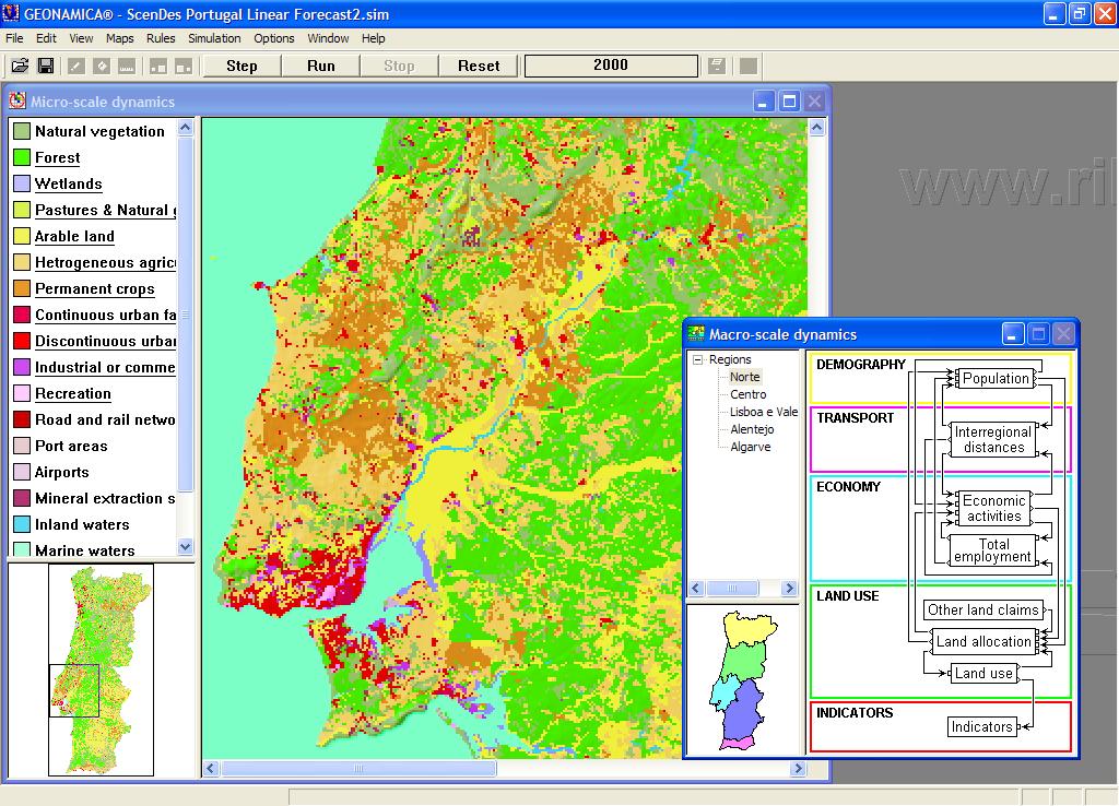
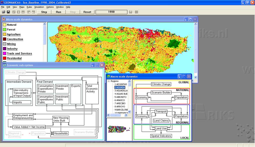
9 Land use modelling with Metronamica Models at 3 coupled spatial scales National, Portugal in EU Regional, 5 NUTS 2 regions Local, cells 25ha 9


10 Regional demands Suitability Land use change over time & Land use at & Interaction time T+1 weights & Zoning Transition Rule Cells change to land-use with highest potential until regional demands Time are met. Loop Accessibility Potential for change & = 10

11 11


12 The single run is not what counts: Working with uncertainty Probability that the cell is occupied by particular land use as the result of uncertainty in parameter(s). Not 1, but 10, 100,, runs Fluctuating 1, 2,, all parameters Milieu- en Natuureffecten Nota Ruimte RIVM, May 2004 Prepared for VROM (Ministry of public housing and Spatial Planning and the Environment 12
13 Content w Spatial Decision Support Systems and Integrated Spatial Planning: what and how? w Land use modeling as a central component of the (I)SDSS w Application through traditional scenarios and storyline and simulation approach w Case studies: Province of Utrecht, the Netherlands PRELUDE (EEA) New infrastructure in Puerto Rico 13
14 Traditional scenario approach Preparation Interviews Construction of preference and zoning maps Workshop 1: Design of alternatives Interactive software tool application Discussion and choice of alternative locations Workshop 2: Calculation of the alternatives Different growth figures Chosen alternatives and LOV-alternative Indicators Analysis of results and discussion 14
15 Story and Simulation approach Problem defini-on Feedback to stakeholder group Development of dra4 narra-ve scenarios Model runs and analysis of results Model development and/ or applica-on Quan-fica-on of narra-ve scenarios (From van Delden, Riddell, Maier, A methodology for linking exploratory storylines and quantitative modelling in support of long-term integrated planning, Environmental Modeling and Software, upcoming) 15
16 Content w Spatial Decision Support Systems and Integrated Spatial Planning: what and how? w Land use modeling as a central component of the (I)SDSS w Application through traditional scenarios and storyline and simulation approach w Case studies: Province of Utrecht, the Netherlands PRELUDE (EEA) New infrastructure in Puerto Rico 16
17 Utrecht - different sectors and their criteria w Environmental hygiene w Social coherence w Economics w Cultural history w Landscape w Traffic and transportation w Ecology & nature w Water resources w Soil 17

18 Utrecht - result of weighing preference maps of different sectors for industry 18


19 Utrecht - designing alternatives for housing Alternative 1 Alternative 2 19
20 Utrecht - calculation of alternatives Alternative 1 Alternative 2 Alternative Environment Explorer 20
21 Utrecht - indicators Open space Job potential 21
22 Story and Simulation approach (SAS) for EEA (in PRELUDE) Qualitative scenarios written by stakeholders 1 st meeting Consistent storylines and model calculations Scenarios translated in qualitative driving forces and model parameters 2 nd meeting 3 rd meeting Comparison by stakeholders of the storylines with the model output Qualitative scenario output translated into quantitative description Quantitative modelling of scenario s EU-level Quantitative modelling of scenario s Regional-level 22
23 SAS in PRELUDE - storylines RIKS Research Institute for Knowledge Systems 23
24 SAS in PRELUDE - storylines RIKS Research Institute for Knowledge Systems 24

25 SAS in PRELUDE modeling results RIKS Research Institute for Knowledge Systems 25
26 SAS in PRELUDE modeling results RIKS Research Institute for Knowledge Systems 26

27 4 October

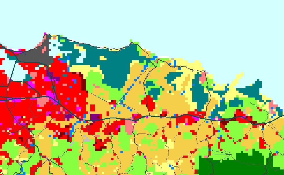
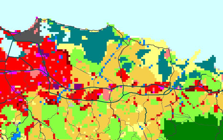

28 Puerto Rico: construction PR PR

29 Puerto Rico: probability for urbanization
30 Others w Other examples: Assessment of desertification risks in the Mediterranean Natural hazard (bush fires, flooding, earthquakes, ) risks in Australia (South Australia) and New Zealand (Christchurch, Auckland, Wellington) Effects of the Common Agricultural Policy in the EU (LUMOCAP) More transport / land use interaction in Saudi Arabia, South Africa, Australia, 30
31 Thank you & time for questions! (or 31
32 RIKS Research Institute for Knowledge Systems 32

33 List of factor maps Land use function Utrecht - the preference maps Factor map Giving a value to the legend items Preference of the sector 33
34 Utrecht - combining the preference maps Housing Services Industry 34
35 Utrecht - area to be planned Current locations Fixed plans until 2005 Plans Expansion Housing ha (673 cells) 1350 ha (54 cells) 1425 ha (57 cellen) 1300 ha (52 cellen) Offices 375 ha (15 cells) 175 ha (7 cells) 125 ha (5 cellen) 50 ha (2 cellen) Industry 3625 ha (145 cells) 175 ha (7 cells) 375 ha (15 cellen) 300 ha (12 cellen) 35
Summary. Recommendations on the Fifth Policy Document on Spatial Planning September 2001
 Summary Recommendations on the Fifth Policy Document on Spatial Planning September 2001 2 Introduction In December 2000 the Dutch Cabinet issued Part 1 of the Fifth National Policy Document on Spatial
UPTAKE AND PATHWAYS OF COASTAL ADAPTATION PROCESSES IN AUSTRALIA
 2015 Effect of Climate Change on the World's Oceans - Santos, Brazil UPTAKE AND PATHWAYS OF COASTAL ADAPTATION PROCESSES IN AUSTRALIA COASTAL COLLABORATION CLUSTER: MEETING COASTAL CHALLENGES Débora M.
Vulnerability and Adaptation to Climate Change
 Vulnerability and Adaptation to Climate Change Prof. Dr. Christoph Görg Department of Social Sciences, University of Kasssel Head of Department Environmental Politics, UFZ Leipzig 1 Introduction: Climate
METRONAMICA: A dynamic spatial land use model applied to Vitoria-Gasteiz
 METRONAMICA: A dynamic spatial land use model applied to Vitoria-Gasteiz Hedwig van Delden 1, Juan Carlos Escudero 2, Inge Uljee 1 and Guy Engelen 1,3 1 Research Institute for Knowledge Systems (RIKS)
Mapping of ecosystems and their services in the EU and its Member States
 Mapping of ecosystems and their services in the EU and its Member States Leon C. Braat, Alterra, Wageningen, The Netherlands MESEU Brussels, July 1, 2015 MESEU FINAL REPORT OCTOBER 2015 The Objective :
16540/14 EE/cm 1 DG E 1A
 Council of the European Union Brussels, 5 December 2014 (OR. en) 16540/14 ENV 965 CULT 139 NOTE From: To: Subject: General Secretariat of the Council Delegations Charter of Rome on Natural and Cultural
Land Use in the context of sustainable, smart and inclusive growth
 Land Use in the context of sustainable, smart and inclusive growth François Salgé Ministry of sustainable development France facilitator EUROGI vice president AFIGéO board member 1 Introduction e-content+
LEDDRA an overview. Helen Briassoulis Department of Geography, University of the Aegean Mytilini, Greece
 LEDDRA an overview, and Ecology Harokopion University, Athens, Greece Outline LEDDRA philosophy LEDDRA approach LEDDRA objectives LEDDRA conceptual framework LEDDRA theoretical framework LEDDRA methodological
European Topic Centre on Land Urban and Soil Systems. Green Infrastructure at EEA
 Green Infrastructure at EEA A SPATIAL APPROACH TO MAPPING GI Stefan Kleeschulte, ETC ULS GI and territorial cohesion 2011 first EEA report on Green Infrastructure Underlining the need to develop tools
ROLE OF SPATIAL PLANNING TOOLS AT MESO-SCALE IN THE MANAGEMENT OF NATURAL RESOURCES, LESSONS LEARNT FROM AFRICAN COUNTRIES
 6th Nov, 2012 ROLE OF SPATIAL PLANNING TOOLS AT MESO-SCALE IN THE MANAGEMENT OF NATURAL RESOURCES, LESSONS LEARNT FROM AFRICAN COUNTRIES Masoom Hamdard Environmental Planning and Assessment for Adaptation
Scenario development for reaching urban and environmental planning integration in the context of climate change*.
 Scenario development for reaching urban and environmental planning integration in the context of climate change*. PhD (cand) Verónica Zagare (TUDelft, ) Dr. Diego Sepúlveda Carmona (TUDelft) September
Use of climate reanalysis for EEA climate change assessment. Blaz Kurnik. European Environment Agency (EEA)
") Use of climate reanalysis for EEA climate change assessment Blaz Kurnik European Environment Agency (EEA) 2016: EEA content priorities Circular economy Climate and Energy Sustainable Development Goals
Use of climate reanalysis for EEA climate change assessment Blaz Kurnik European Environment Agency (EEA) 2016: EEA content priorities Circular economy Climate and Energy Sustainable Development Goals
Overview of LEDDRA. Three years of research on responses to LEDD
 Overview of LEDDRA Three years of research on responses to LEDD, Coordinating institution (Greece) Project partners Agricultural University of Athens (Greece) 3D-Environmental Change (The Netherlands)
I&CLC2000 in support to new policy initiatives (INSPIRE, GMES,..)
") I&CLC2000 in support to new policy initiatives (INSPIRE, GMES,..) Manfred Grasserbauer, Director Joint Research Centre Institute for Environment and Sustainability 1 IMAGE 2000 European mosaic of satellite
I&CLC2000 in support to new policy initiatives (INSPIRE, GMES,..) Manfred Grasserbauer, Director Joint Research Centre Institute for Environment and Sustainability 1 IMAGE 2000 European mosaic of satellite
Pathways. Pathways through the Geography Major
 Pathways through the Major majors may structure their course selections around a sub-field of. Pathways are suggestions for classes in, in related disciplines, and skills training. Each pathway includes
Making maps: Traditions and perceptions in Europe. European spatial planning and cartographic representations
 ESPON Create Europe! Making maps: Traditions and perceptions in Europe Dr. Stefanie Dühr University of the West of England, Bristol, UK European spatial planning and cartographic representations Scenarios.
Land Use Planning and Agriculture: Austrian Experiences and Challenges I
 Land Use Planning and Agriculture: Austrian Experiences and Challenges I SULANET Summer School 2016 Walter Seher BOKU Vienna 1 Land Use Planning and Agriculture 2 Land Use Planning and Agriculture Agriculture
Economic Benefit Study on Value of Spatial Information Australian Experience
 Economic Benefit Study on Value of Spatial Information Australian Experience Dr Zaffar Sadiq Mohamed-Ghouse Director, International Relations Cooperative Research Centre for Spatial Information zsadiq@crcsi.com.au
Mapping and Assessment of Ecosystems and their Services
 Mapping and Assessment of Ecosystems and their Services ALTER-Net Conference 2013: Science underpinning the EU 2020 Biodiversity Strategy. April 2013 Gent Joachim MAES 1 This presentation is based on the
Planning Road Networks in New Cities Using GIS: The Case of New Sohag, Egypt
 Planning Road Networks in New Cities Using GIS: The Case of New Sohag, Egypt Mostafa Abdel-Bary Ebrahim, Egypt Ihab Yehya Abed-Elhafez, Kingdom of Saudi Arabia Keywords: Road network evaluation; GIS, Spatial
Agent Based Modeling and Simulation in the Social Sciences. Frank Witmer Computing and Research Services 14 May 2014
 Agent Based Modeling and Simulation in the Social Sciences Frank Witmer Computing and Research Services 14 May 2014 Outline What are agent based models? How do they work? What types of questions are they
Smart City Governance for effective urban governance. David Ludlow Assoc. Professor European Smart Cities University of the West of England, Bristol
 Smart City Governance for effective urban governance David Ludlow Assoc. Professor European Smart Cities University of the West of England, Bristol Complexities of urban territorial governance Complexities
GI AND WATERSHED MANAGEMENT: Discussing GI relevance Towards monitoring EU Legal Framework
 DGT- Direcção Geral do Território GI AND WATERSHED MANAGEMENT: Discussing GI relevance Towards monitoring EU Legal Framework Maria José Vale and Raquel Saraiva INSPIRE CONFERENCE 2012 ISTAMBUL Summary
Key Indicators for Territorial Cohesion and Spatial Planning in Preparing Territorial Development Strategies
 ESPON Evidence in a North European Context Challenges and Opportunities for Territorial Development and Cohesion in a North European Macro Region, 10-11 April, 2014, Vilnius, Lithuania Key Indicators for
SPLAN-Natura Towards an integrated spatial planning approach for Natura th January, 2017 Brussels. Commissioned by DG Environment
 SPLAN-Natura 2000 Towards an integrated spatial planning approach for Natura 2000 Commissioned by DG Environment 17 th January, 2017 Brussels V. Simeonova (Ph.D.) Drivers towards integrating Biodiversity
Issue to be addressed
 Climate change impacts in fluvial, coastal and transition zones in Mediterranean environments altered by human activities: Guadalfeo and Adra river mouths Andrea Lira Loarca - aliraloarca@ugr.es Manuel
City of Jerez Urban Core Densification proposal; An Agent Based Spatio-temporal model
 Modelling urban population allocation City of Jerez Urban Core Densification proposal; An Agent Based Spatio-temporal model Elke Sauter Julia Úbeda Who we are & why we are here Masters programme: Geographical
PURR: POTENTIAL OF RURAL REGIONS UK ESPON WORKSHOP Newcastle 23 rd November Neil Adams
 PURR: POTENTIAL OF RURAL REGIONS UK ESPON WORKSHOP Newcastle 23 rd November 2012 Neil Adams PURR: Potential of Rural Regions Introduction Context for the project A spectrum of knowledge Rural Potentials
The Twin2Go Project: From applying panaceas to mastering complexity: Towards adaptive water governance in river basins
 The Twin2Go Project: From applying panaceas to mastering complexity: Towards adaptive water governance in river basins From panaceas to context sensitive analyses and recommendations Water governance reform
Regional Plan 4: Integrating Ecosystem Services Mapping into Regional Land Use Planning
 Rural-Urban Outlooks: Unlocking Synergies (ROBUST) ROBUST receives funding from the European Union s Horizon 2020 research and innovation programme under grant agreement No 727988.* October 2018 Natural
TERRITORIAL IMPACT ASSESSMENT: AN APPROACH TO IMPROVE THE VERTICAL AND HORIZONTAL INTEGRATION OF EU POLICIES
 TERRITORIAL IMPACT ASSESSMENT: AN APPROACH TO IMPROVE THE VERTICAL AND HORIZONTAL INTEGRATION OF EU POLICIES Naja Marot & Mojca Golobič Biotehnical Faculty, University of Ljubljana, Slovenia RSA Workshop
Dr.Sinisa Vukicevic Dr. Robert Summers
 Dr.Sinisa Vukicevic Dr. Robert Summers "Planning" means the scientific, aesthetic, and orderly disposition of land, resources, facilities and services with a view to securing the physical, economic and
Chisoni Mumba. Presentation made at the Zambia Science Conference 2017-Reseachers Symposium, th November 2017, AVANI, Livingstone, Zambia
 Application of system dynamics and participatory spatial group model building in animal health: A case study of East Coast Fever interventions in Lundazi and Monze districts of Zambia Chisoni Mumba Presentation
HELSINKI COMMISSION Baltic Marine Environment Protection Commission
 HELSINKI COMMISSION Baltic Marine Environment Protection Commission HELCOM RECOMMENDATION 24/10 Adopted 25 June 2003, having regard to Article 20, Paragraph 1 b) of the 1992 Helsinki Convention IMPLEMENTATION
Supporting Strategic Plan Development in Flanders
 Supporting Strategic Plan Development in Flanders Guy Engelen, Inge Uljee, Anne Gobin, Leen Van Esch, Hans van der Kwast VITO Flemish Institute for Technological Research Boeretang 200 2400 Mol Belgium
Sustainable development of the Greek islands
 Sustainable development of the Greek islands Coccossis H. in Camarda D. (ed.), Grassini L. (ed.). Interdependency between agriculture and urbanization: Conflicts on sustainable use of soil and water Bari
Climate Services in Practice UK Perspective
 Climate Services in Practice UK Perspective Chris Hewitt ICCS, Columbia University, October 2011 Overview Perspectives on: Why have a climate service? What is a climate service? UK activities Examples
The National Policy Strategy for Infrastructure and Spatial Planning CODE24 CONFERENCE. Emiel Reiding
 The National Policy Strategy for Infrastructure and Spatial Planning Emiel Reiding Structure of presentation 1. Spatial planning in the Netherlands 2. National Policy Strategy Aims National interests 3.
Assessment and valuation of Ecosystem Services for decision-makers
 Assessment and valuation of Ecosystem Services for decision-makers An introduction to the ARIES approach Ferdinando Villa *, Ken Bagstad Gary Johnson, Marta Ceroni *Basque Center for Climate Change, Bilbao,
Natura 2000 and spatial planning. Executive summary
 Natura 2000 and spatial planning Executive summary DISCLAIMER The information and views set out in this study are those of the author(s) and do not necessarily reflect the official opinion of the Commission.
GLP Workshop on. The design of integrative models of natural and social systems in land change science
 The Global land Project Nodal Office on Integration and Modelling, Aberdeen, UK GLP Workshop on The design of integrative models of natural and social systems in land change science Introduction Post Workshop
Breaking away from trend-based analysis for regional modelling and planning
 22nd International Congress on Modelling and Simulation, Hobart, Tasmania, Australia, 3 to 8 December 2017 mssanz.org.au/modsim2017 Breaking away from trend-based analysis for regional modelling and planning
Edexcel Geography Advanced Paper 2
 Edexcel Geography Advanced Paper 2 SECTION B: SHAPING PLACES Assessment objectives AO1 Demonstrate knowledge and understanding of places, environments, concepts, processes, interactions and change, at
From individual perceptions and statistical data to instruments for land resource management
 From individual s and statistical data to instruments for land Land Ulrike Tappeiner, Innsbruck / Bolzano Status quo versus Stefan Marzelli, München Instruments Status quo versus The two sides of the same
6 th GLOBAL SUMMIT ON URBAN TOURISM 4 6 December 2017, Kuala Lumpur (Malaysia)
") 6 th GLOBAL SUMMIT ON URBAN TOURISM 4 6 December 2017, Kuala Lumpur (Malaysia) SUMMARY/CONCLUSIONS Esencan TERZIBASOGLU Director Destination Management and Quality eterzibasoglu@unwto.org 6TH GLOBAL SUMMIT
6 th GLOBAL SUMMIT ON URBAN TOURISM 4 6 December 2017, Kuala Lumpur (Malaysia) SUMMARY/CONCLUSIONS Esencan TERZIBASOGLU Director Destination Management and Quality eterzibasoglu@unwto.org 6TH GLOBAL SUMMIT
COMMON CONCEPTUAL AND OPERATIONAL FRAMEWORKS FOR RESEARCH AND SUSTAINABLE MANAGEMENT OF NESTED SOCIO-ECOLOGICAL SYSTEMS ACROSS LARGE WATERSHEDS
 COMMON CONCEPTUAL AND OPERATIONAL FRAMEWORKS FOR RESEARCH AND SUSTAINABLE MANAGEMENT OF NESTED SOCIO-ECOLOGICAL SYSTEMS ACROSS LARGE WATERSHEDS Angheluta VADINEANU 1 & Nusret KARAKAYA 2 1 Department of
Spatial Disaggregation of Land Cover and Cropping Information: Current Results and Further steps
 CAPRI CAPRI Spatial Disaggregation of Land Cover and Cropping Information: Current Results and Further steps Renate Koeble, Adrian Leip (Joint Research Centre) Markus Kempen (Universitaet Bonn) JRC-AL
EO Information Services. Assessing Vulnerability in the metropolitan area of Rio de Janeiro (Floods & Landslides) Project
 Project") EO Information Services in support of Assessing Vulnerability in the metropolitan area of Rio de Janeiro (Floods & Landslides) Project Ricardo Armas, Critical Software SA Haris Kontoes, ISARS NOA World
EO Information Services in support of Assessing Vulnerability in the metropolitan area of Rio de Janeiro (Floods & Landslides) Project Ricardo Armas, Critical Software SA Haris Kontoes, ISARS NOA World
Economic development in rural regions in the EU: empirical findings and theories
 Economic development in rural regions in the EU: empirical findings and theories Presentation at the IAMO Forum 2013 Rural areas in transition, June 19-21, 2013 Dr. Ida Terluin, Agricultural Economics
Dar es Salaam - Reality Check Workshop
 Dar es Salaam - Reality Check Workshop hosted by GIZ and Dar es Salaam City Council Introduction: Key Urban Characteristics of Dar es Salaam Challenges and Opportunities for Resilient Development in the
DEPARTMENT OF GEOGRAPHY B.A. PROGRAMME COURSE DESCRIPTION
 DEPARTMENT OF GEOGRAPHY B.A. PROGRAMME COURSE DESCRIPTION (3 Cr. Hrs) (2340100) Geography of Jordan (University Requirement) This Course pursues the following objectives: - The study the physical geographical
Geographical knowledge and understanding scope and sequence: Foundation to Year 10
 Geographical knowledge and understanding scope and sequence: Foundation to Year 10 Foundation Year 1 Year 2 Year 3 Year 4 Year 5 Year 6 Year level focus People live in places Places have distinctive features
CAN THO URBAN DEVELOPMENT AND RESILIENCE PROJECT
 CAN THO URBAN DEVELOPMENT AND RESILIENCE PROJECT 1 Phnom Penh Can Tho City HCM City EAST SEA 2 1 3 Highest Water Level WATER LEVEL RAISE IN CAN THO DURING LAST 40 YEARS 4 2 Land subsidence a threat that
INDIANA ACADEMIC STANDARDS FOR SOCIAL STUDIES, WORLD GEOGRAPHY. PAGE(S) WHERE TAUGHT (If submission is not a book, cite appropriate location(s))
 WHERE TAUGHT (If submission is not a book, cite appropriate location(s))") Prentice Hall: The Cultural Landscape, An Introduction to Human Geography 2002 Indiana Academic Standards for Social Studies, World Geography (Grades 9-12) STANDARD 1: THE WORLD IN SPATIAL TERMS Students
Prentice Hall: The Cultural Landscape, An Introduction to Human Geography 2002 Indiana Academic Standards for Social Studies, World Geography (Grades 9-12) STANDARD 1: THE WORLD IN SPATIAL TERMS Students
One Map Policy to Support National Development in Indonesia
 One Map Policy to Support National Development in Indonesia Dr. Nurwadjedi Sarbini Deputy of Thematic Geospatial Information Geospatial Information Agency (BIG) Geosmart Asia, September 29 October 1, 2015
Modelling the influence of land use and land cover change on ecosystem services
 Modelling the influence of land use and land cover change on ecosystem services Peter Verburg Institute for Environmental Studies VU University Amsterdam With contributions of: Derek van Berkel, Wieteke
ENSURE. Coordinator: Hormoz MODARESSI Website:
 ENSURE Coordinator: Hormoz MODARESSI h.modaressi@brgm.fr Website: http://ensureproject.eu/ The project is financed by the European Commission under the 7th Framework Programme for Research and Technological
SPIMA Spatial dynamics and strategic planning in metropolitan areas
 Targeted Analysis SPIMA Spatial dynamics and strategic planning in metropolitan areas Executive Summary Conference version 1 February 2018 0 1. Background To address the challenges of metropolitan development
World Geography. WG.1.1 Explain Earth s grid system and be able to locate places using degrees of latitude and longitude.
 Standard 1: The World in Spatial Terms Students will use maps, globes, atlases, and grid-referenced technologies, such as remote sensing, Geographic Information Systems (GIS), and Global Positioning Systems
Assessment of Sustainable Land Use within the Town Planning Process Experiences with a Multi Criteria Approach (MCA)
") Assessment of Sustainable Land Use within the Town Planning Process Experiences with a Multi Criteria Approach (MCA) Dipl.-Geogr. Sophie Schetke Dipl.-Ing. Benedikt Frielinghaus, University of Bonn, Germany
Assessment of Sustainable Land Use within the Town Planning Process Experiences with a Multi Criteria Approach (MCA) Dipl.-Geogr. Sophie Schetke Dipl.-Ing. Benedikt Frielinghaus, University of Bonn, Germany
facing Societal needs Climate science towards actionable information PM Ruti Thanks to: S Somot (CNRM) M DeFelice (ENEA) R Vautard (CEA)
 M DeFelice (ENEA) R Vautard (CEA)") Climate science towards actionable information facing Societal needs PM Ruti Thanks to: S Somot (CNRM) M DeFelice (ENEA) R Vautard (CEA) Challenges of climate services A short story Research on climate
Climate science towards actionable information facing Societal needs PM Ruti Thanks to: S Somot (CNRM) M DeFelice (ENEA) R Vautard (CEA) Challenges of climate services A short story Research on climate
Overcoming Complexities on the Interface of Infrastructure and Land Use
 Date 22-11-2013 1 Overcoming Complexities on the Interface of Infrastructure and Land Use Towards design preconditions for integrated regional development Niels Heeres & Jos Arts University of Groningen,
Commercialisation. Lessons learned from Dutch weather market
 Commercialisation Lessons learned from Dutch weather market Where information comes together weather traffic public transport Weather, traffic and public transport. Daily actual information that influences
Visualization tools for coastal climate change vulnerability assessment and adaptation guidelines: a case study in Cartagena, Colombia
 Visualization tools for coastal climate change vulnerability assessment and adaptation guidelines: a case study in Cartagena, Colombia Vivian Ochoa, Paula Cristina Sierra-Correa, Venus Rocha, Francisco
Dutch spatial planning: from implicit to explicit sustainable urban development
 Dutch spatial planning: from implicit to explicit sustainable urban development Jan Goedman (VROM*) Wim Heiko Houtsma (VROM) Wil Zonneveld (Delft University) *Dutch Ministry of Housing, Spatial Planning
What is Spatial Planning?
 Spatial Planning in the context of the Responsible Governance of Tenure What is Spatial Planning? Text-only version This course is funded by the European Union through the EU-FAO Improved Global Governance
Land Use Modelling for Environmental and Ecological Policy Assessment:
 Judith Borsboom Land Use Modelling for Environmental and Ecological Policy Assessment: Sustainable Netherlands Study in collaboration with: Wageningen University & Research centre WL Delft Hydraulics Arcadis
EXPLORING THE FUTURE WATER INFRASTRUCTURE OF CITIES
 EXPLORING THE FUTURE WATER INFRASTRUCTURE OF CITIES Eng. Arlex Sanchez Torres PhD. R.K. Price PhD. Z. Vojinovic Jan 24 th - 2011 The future of urban water: Solutions for livable and resilient cities SWITCH
Implementing a Spatial Decision Support System for Puerto Rico: The Political Process
 Implementing a Spatial Decision Support System for Puerto Rico: The Political Process Brugge,, Belgium April 2008 Guy Engelen and Elías R. Gutiérrez, Ph.D. VITO - Flemish Institute for Technological Research
Approach of Estimating Tsunami Economic Losses in The. Okinawa Island with Scenario-based of Input-Output Table. and Okinawa Earthquake Sources
 ORIGINAL ARTICLE Approach of Estimating Tsunami Economic Losses in The Okinawa Island with Scenario-based of Input-Output Table and Okinawa Earthquake Sources Kwanchai Pakoksung 1*, Anawat Suppasri 1,
Contract title: Technical assistance for multi-annual programming of future cross border cooperation programme in the Romania-Serbia cooperation area
 GOVERNMENT OF ROMANIA SERBIAN GOVERNMENT Contract title: Technical assistance for multi-annual programming of future cross border cooperation programme in the Romania-Serbia cooperation area Reference:
Landslide Hazard Assessment Methodologies in Romania
 A Scientific Network for Earthquake, Landslide and Flood Hazard Prevention SciNet NatHazPrev Landslide Hazard Assessment Methodologies in Romania In the literature the terms of susceptibility and landslide
Emergency Management Service (EMS) mapping
 mapping") GMES Emergency Management Service (EMS) mapping Frédéric BASTIDE GMES unit, European Commission UN-SPIDER Expert Meeting: "Crowdsource Mapping for Disaster Risk Management and Emergency Response" 3-5 December,
GMES Emergency Management Service (EMS) mapping Frédéric BASTIDE GMES unit, European Commission UN-SPIDER Expert Meeting: "Crowdsource Mapping for Disaster Risk Management and Emergency Response" 3-5 December,
Alps Results from the ESPON Project. Common spatial perspectives for the Alpine area. Towards a common vision
 Results from the ESPON Project Alps 2050 Common spatial perspectives for the Alpine area. Towards a common vision Tobias Chilla, University of Erlangen Cooperation Alps 2020+ 1 & 2 October 2018 Salzburg
Environmentally-induced Population Displacements: Conclusions from PERN s Online Seminar
 Environment, Forced Migration & Social Vulnerability International Conference 9-11 October 2008 Bonn, Germany www.efmsv2008.org Environmentally-induced Population Displacements: Conclusions from PERN s
Towards the Integration of Economic and Land Use Change Models
 International Environmental Modelling and Software Society (iemss) 2010 International Congress on Environmental Modelling and Software Modelling for Environment s Sake, Fifth Biennial Meeting, Ottawa,
Workshop B Spatial positioning and definition of characteristics
 This presentation expresses the author's views. It does not necessarily reflect the opinion of the ESPON Monitoring Committee, which is not liable for any use that may be made of the information provided.
Overview of proposed approach to the Desktop Study to inform discussion
 LTAS Phase 2: Climate Change Implications for the Human Settlements sector in South Africa Overview of proposed approach to the Desktop Study to inform discussion Project Team Project Lead: Crispian Olver
Directorate E: Sectoral and regional statistics Unit E-4: Regional statistics and geographical information LUCAS 2018.
 EUROPEAN COMMISSION EUROSTAT Directorate E: Sectoral and regional statistics Unit E-4: Regional statistics and geographical information Doc. WG/LCU 52 LUCAS 2018 Eurostat Unit E4 Working Group for Land
Figure 10. Travel time accessibility for heavy trucks
 Figure 10. Travel time accessibility for heavy trucks Heavy truck travel time from Rotterdam to each European cities respecting the prescribed speed in France on the different networks - Road, motorway
European Regional and Urban Statistics
 European Regional and Urban Statistics Dr. Berthold Feldmann berthold.feldmann@ec.europa.eu Eurostat Structure of the talk Regional statistics in the EU The tasks of Eurostat Regional statistics Urban
Analysis of Future Urban Growth Scenario of Damaturu Town in Yobe State, Nigeria
 Review Article Analysis of Future Urban Growth Scenario of Damaturu Town in Yobe State, Nigeria Muhammad Isma il* 1, Ibrahim Jaro Musa 1 and Ahmed Abubakar Jajere 2 1 Department of Geography, Ahmadu Bello
Estimation of the area of sealed soil using GIS technology and remote sensing
 From the SelectedWorks of Przemysław Kupidura 2010 Estimation of the area of sealed soil using GIS technology and remote sensing Stanisław Białousz Przemysław Kupidura Available at: https://works.bepress.com/przemyslaw_kupidura/14/
INTEGRATING CLIMATE VULNERABILITY & RISK ASSESSMENT INTO URBAN SPATIAL PLANNING PROCESS
 INTEGRATING CLIMATE VULNERABILITY & RISK ASSESSMENT INTO URBAN SPATIAL PLANNING PROCESS (CASE STUDY: BLITAR CITY, EAST JAVA, INDONESIA) SHINTA MICHIKO PUTERI, ST, MT. DR. IR. DENNY ZULKAIDI, MUP. WRITER
Summary of Available Datasets that are Relevant to Flood Risk Characterization
 Inter-Agency Characterization Workshop February 25-27, 2014 USACE Institute for Water Resources, Alexandria, VA, IWR Classroom Summary of Available Datasets that are Relevant to Characterization National
Paul Bridge Meteorologist Vaisala/UKMO Work Groups/Committees: WMO/TRB/AMS
 Paul Bridge Meteorologist Vaisala/UKMO Work Groups/Committees: WMO/TRB/AMS Introduction (a) Identify and establish, if possible, inventories of transport networks in the ECE region which are vulnerable
TOWARDS STRATEGIC SPATIAL PLANNING IN JAMAICA: THE NATIONAL SPATIAL PLAN
 TOWARDS STRATEGIC SPATIAL PLANNING IN JAMAICA: THE NATIONAL SPATIAL PLAN JIEP 5th Biennial Conference on the Environment: Balancing National Development and Environmental Protection June 6, 2011 Jamaica
PLANNING (PLAN) Planning (PLAN) 1
 Planning (PLAN) 1") Planning (PLAN) 1 PLANNING (PLAN) PLAN 500. Economics for Public Affairs Description: An introduction to basic economic concepts and their application to public affairs and urban planning. Note: Cross-listed
Planning (PLAN) 1 PLANNING (PLAN) PLAN 500. Economics for Public Affairs Description: An introduction to basic economic concepts and their application to public affairs and urban planning. Note: Cross-listed
By Lillian Ntshwarisang Department of Meteorological Services Phone:
 By Lillian Ntshwarisang Department of Meteorological Services Phone: +267 3612200 Email: lntshwarisang@gov.bw/ lntshwarisang@gmail.com Introduction Mandate of DMS Function of the Department Services to
Geography. Geography A. Curriculum Planner and Skills Mapping Grid GCSE Version 1 October 2012
 Geography GCSE 2012 Geography A Curriculum Planner and Skills Mapping Grid Version 1 October 2012 www.ocr.org.uk/gcse2012 Year 10 Exam work Controlled Assessment Autumn 1 Autumn 2 Spring 1 Spring 2 Summer
Proposed Scope of Work Village of Farmingdale Downtown Farmingdale BOA Step 2 BOA Nomination Study / Draft Generic Environmental Impact Statement
 Proposed Scope of Work Village of Farmingdale Downtown Farmingdale BOA Step 2 BOA Nomination Study / Draft Generic Environmental Impact Statement The scope of work that follows incorporates and covers
Urban-Rural Partnerships in Europe
 Disclaimer: The views expressed in this document are those of the author, and do not necessarily reflect the views and policies of the Asian Development Bank (ADB), its Board of Directors, or the governments
2 nd Semester. Core Courses. C 2.1 City and Metropolitan Planning. Module 1: Urban Structure and Growth Implications
 2 nd Semester Core Courses C 2.1 City and Metropolitan Planning Module 1: Urban Structure and Growth Implications Growth of cities; cities as engine of growth; urban sprawl; land value, economic attributes
Spatial Planning and Territorial Development at the Regional Level
 Spatial Planning and Territorial Development at the Regional Level Vincent Nadin University of the West of England, UK Spatial Planning and Territorial Development at the Regional Level Vincent Nadin University
GEOGRAPHY YEAR 11 ATAR 2019 COURSE OUTLINE
 GEOGRAPHY YEAR 11 ATAR 2019 COURSE OUTLINE Geography ATAR Year 11 Semester 1 Unit 1 Natural and ecological hazards 1 3 Geographical skills Mapping skills identify and interpret a variety of topographic
HORIZON 2030: Land Use & Transportation November 2005
 PROJECTS Land Use An important component of the Horizon transportation planning process involved reviewing the area s comprehensive land use plans to ensure consistency between them and the longrange transportation
Harmonizing spatial databases and services at local and regional level
 Harmonizing spatial databases and services at local and regional level A. Ionita 1, M. Caian 2, V. Vassilev 3, V. Craciunescu 2, I. Nedelcu 4 1 Research Institute for Artificial Intelligence, Bucuresti,
COUNCIL OF THE EUROPEAN UNION. Brussels, 2 May /14 CULT 68
 COUNCIL OF THE EUROPEAN UNION Brussels, 2 May 2014 9129/14 CULT 68 NOTE from: General Secretariat of the Council to: Permanent Representatives Committee (Part 1) / Council No. prev. doc.: 8892/14 CULT
High speed network in Hauts-de-France Region. Värnamo, 17 th May 2018
 High speed network in Hauts-de-France Region Värnamo, 17 th May 2018 Hauts-de-France at the crossroads of the North-West Europe High speed train approach in France In the 1980s: will to link the main cities
A FOSS approach to Integrated Water Resource Management: the case study of Red-Thai Binh rivers system in Vietnam
 A FOSS approach to Integrated Water Resource Management: the case study of Red-Thai Binh rivers system in Vietnam Carolina Arias Munoz1, Maria Antonia Brovelli1, Simone Corti1, Marco Micotti2, Rodolfo