Scale 1" = 200' ST 11. This Lot. Road
|
|
|
- Adela Allison
- 5 years ago
- Views:
Transcription
1 TA R8&9 WELS, Maine
2 Scale 1" = 200' 1 This Lot 3 Road ST 11 1
3 PDF-XChange PROPERY RECORD CARD - TOWNSHIP NAME w w w.docu-track.co m Click to buy NOW! NEW ENGLAND TELEPHONE TA R8 & 9 WELS REMARKS \MSOL\data\MRS\ DATE BOOK/PAGE DATE COUNTY BOOK/PAGE PENOBSCOT MAP NO. PE030 PDF-XChange w w w.docu-track.co m Click to buy NOW! PLAN NO. 01 Account # 911 Road Name Cedar Lake Road Building 1 of 1 Comment Review date 11/7/2011 Review by Nancy Weeks land changed from tar to dirt first review, location previously assumed to be on Rt 11, appears to be on Cedar Lake road (dirt) LOT NO. 3 SUBD. LOT EXEMPT LEASE NO. LEASE FROM ADDRESS TA R8 & 9 WELS (LONG A, W. SEBOIS), PENOBSCOT Map PE030 Plan 01 Lot 3 Std Lot Size Std Depth Avg Depth Front Ft Price Parcel Acres LAND VALUATION1.0 acre 0 $ Base Lot Type Base Lot Unit Value Factor Base Lot Value Undev Dirt Rd 0.23 $3, $1,900 Acreage Wet Land/Barren $280 $70 $0 $0 Topography Adj 0.00 Waterfront Front Feet 0 Depth Factor Excess Factor Topography Lake Name 0.00 Waterfront Acres 0.00 Other Acres $/ac Paving First 250 fr ft Next 300 fr ft 550+ fr ft Total Waterfront Value 0 $0 Well Type $0 GPS Coordinates Notes 2.7mi down west side Cedar Lake Road, off south side Rt 11.deed says 5.6mi from Pisc/Penob TL Date Printed 3/28/ $ Topography $0 $0 $0 0.23ac. Unclassified Total Buildings: Tree Growth Valuation: 1, Total Property: Tree Growth Acres: 1, Total Acres:
4 PDF-XChange Foundation Basement w w w.docu-track.co m Roof Click to buy NOW! Framing Interior Exterior Floors Heating Plumbing Lighting TOTAL GRADE COND Story Height 1st = One Story 1.5st = 1(1/2) Story 1.75st = 1(3/4) Story 2st = 2 Story 0 % CONSTRUCTION DETAILS ADDS/DEDUCTS Account # No basement area 0 0 Finished area 0 0 Stories Loft area 0 0 Finished loft area 0 0 No heat area Other 0 SURVEY BY Jon Carrell 10/17/1997 Total Adds & Deducts 0 FUNCTIONAL OBSOL % ECONOMIC OBSOL % Mh 0.00 Area Access 0.00 No Elec 0.00 TOTAL 0.00 Services 0.00 FACTOR 0.00 Topo 0.00 Building 1 of 1 Current Cost Factor 1.25 TOTAL 0.00 FACTOR NEW ENGLAND TELEPHONE Grade L 0 W Area Total Cost Rep Adjustment = Adjusted Cost Rep x Current Cost Factor Condition Functional Factor Economic Factor Cost Rep Less Dep Plus Outbuildings TOTAL VALUE BUILDINGS Cost Rep PDF-XChange w w w.docu-track.co m Click to buy NOW! OUTBUILDING Floors Foundation Ext. Walls Roof Interior Wall-Height Electricity Other Other Cost TOTAL COST Size Area COST OF REP Unit Additions Unit Cost COST FACTOR Phys/Func/Ec% RCNLD /0/0 0
 624-5611 2012 UNORGANIZED TERRITORY PROPERTY TAX BILL REAL ESTATE or PERSONAL PROPERTY NEW ENGLAND TELEPHONE ATTENTION: ROY DRUKKER 770 ELM STREET MANCHESTER,")
5 MAINE REVENUE SERVICES PROPERTY TAX DIVISION P. O. BOX 9106 AUGUSTA, MAINE (207) UNORGANIZED TERRITORY PROPERTY TAX BILL REAL ESTATE or PERSONAL PROPERTY NEW ENGLAND TELEPHONE ATTENTION: ROY DRUKKER 770 ELM STREET MANCHESTER, NH Property Account # Ownership Percentage: % Map PE030 Plan 01 Lot 3 Mill Rate: TA R8 & 9 WELS, Penobscot Total Land Value: 1,900 Total Building Value: 0 Personal Property Valuation: 0 ExemptValuation: 0 Taxable Value: 1,900 Tax: /11/12 Payment Amount Due: 0.00 Acreage 0.23 * The above tax information is as of April 1, By law we must tax the owner of the parcel as of that date. * Tax is overdue if not paid by October 1, 2012 and interest is at the rate of 7.00% annually. * Make checks payable to Treasurer State of Maine. * Partial payments are accepted. Please call for forms. Interest will continue to accrue on the outstanding balance. * If you would like a copy of the Unorganized Territory Fiscal report send request to Unorganized Territory Fiscal Administrator, 66 State House Station, Augusta, ME * Note any address changes on the portion below. * Questions or concerns about your tax bill can be addressed by calling (207) DETACH THIS PORTION AND RETURN WITH PAYMENT Maine Revenue Services P.O. Box 9106 Augusta, ME Unorganized Territory Tax Bill - Real Estate or Personal Property PROPERTY TAX BILL NEW ENGLAND TELEPHONE ATTENTION: ROY DRUKKER 770 ELM STREET MANCHESTER, NH Property Account # Land Value Building Value Personal Property Value Total Exemptions: Taxable Value: Total Due: 1, , Map PE030 Plan 01 Lot 3 TA R8 & 9 WELS, Penobscot
6
7
8
9
10
11 Van Buren, Maine
12 Tax Lot Number Name (Last First MI) Book & Page Ref. 1 MORIN JOHN P B815 P213 2 MICHAUD PATRICK B835 P213 5 PARENT, NORMAN & B1543 P250 05/04/07 JENNIFER 6 LAJOIE KIM S B1399 P145 6A DERNLAN, GARY D. B1512 P119 7A PARENT, GERALD B1508 P96 04/05/07 7B NORTHERN NEW ENGLAND B1590 P162 TELEPHONE 8 G.R. TIMBER HOLDINGS LLC B1540 P35 9 BACON EUGENE ANDRE B700 P32 10 BACON EUGENE ANDRE B700 P32 11 VAILLANCOURT HERBERT B694 P TRAPP EDITH B1085 P TRAPP EDITH B768 P CASHMAN ROBERT R B1124 P10 16 LARRABEE, ALLEN W. B1667 P32 01/19/10 17 DERNLAN, GARY D. B1619 P260 11/02/08 18 & 19 TILLEY TRACEY 20 G.R. TIMBER HOLDINGS, B1513 P104 LLC 22 DUMOND ENTERPRISES, INC. B1610 P72 08/25/08 23A G.R. TIMBER HOLDINGS, B1584 P261 LLC 23B TILLEY FRANKLIN D B1332 P18 24 & 25 CYR GEORGE JR B1366 P BOUCHARD CHRISTMAS TREE FARM 27 DERNLAN GARY D B1384 P G R TIMBER HOLDINGS LLC B1239 P MCGRATH, MARTIN J. B1555 P85 31 MORIN GILMAN L B287 P GORDON, DENNIS J. B1592 P MCGRATH, MARTIN J. B1555 P85 34 AMENOUNVE, KANGNI B1670 P61 02/22/10 35A BERRY, JUDE B1103 P164 35B CALAHAN JAMES G B1164 P CYR MICHAEL PETER B900 P80 37 PAYNE ESQUAREE B534 P41 38 BUTT, LARRY S. B538 P HASSELL, WILLIAM B1495 P TILLEY FRANKLIN D B1332 P18 41 CASTONGUAY, SHERI J. B1445 P228 41A GERSON, TARA LEE B1670 P266 03/01/10 B843 P138 41E CASTONGUAY PIERRE R B1029 P83 42 TILLEY, TRACEY LISA B1583 P FONGEMIE KENNETH B1059 P MCBEE, DANNY D. B1609 P277 08/20/08 45 DAIGLE RICHARD B1322 P HEATH SANDRA M B956 P25 47A G R TIMBER HOLDINGS LLC B1420 P122
13
14

15
16
17
18
19
20
21
22
23 Warren, Maine
24 2010-Warren-Tax-Maps.pdf 18 of 27 3/28/2013 1:55 PM
25
26
27
28
29
30
31
32
33
34
35 Washburn, Maine
36

37
38
39
40
41
42
43
44
45
46
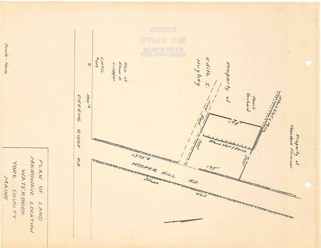
47 Waterboro, Maine
48

49
50
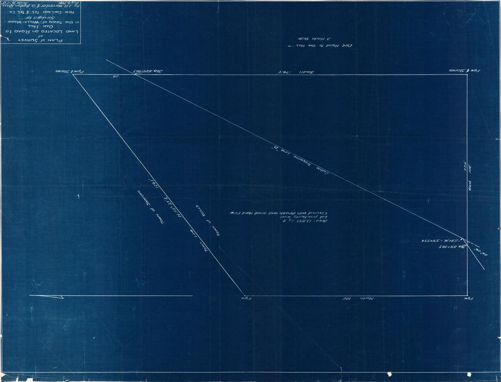
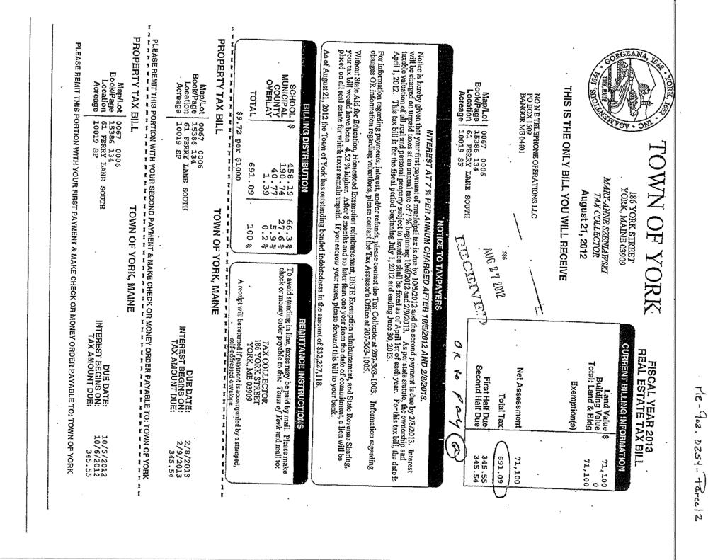
51
52
53
54
55
56
57
58
59 Wells, Maine
60 ' 85' 158' 197' 217' 249.5' 217.2' 248.5' 204.2' 184.2' 138.2' 229.7' ' 111' 176.9' 100' 100' 207' 36' 175' 239' 250' 25' 262.7' 262' 175' 175' 175' 175' 1 Horace Mills Sanford Grace Ln ' 310' 310' 50' 55' 55' ' ' 130' 50A 50C 50B ' 250' '
61 Print Summary No Image Powered by Vision Government Solutions, Inc. MBLU : 0044/040 / / / / Location: HORACE MILLS RD Owner Name: NORTHERN NEW ENGLAND TEL OPERATIONS LLC Account Number: 0 Parcel Value Item Assessed Value Buildings 0 Xtra Bldg Features 0 Outbuildings 0 Land 87,470 Total: 87,470 Owner of Record NORTHERN NEW ENGLAND TEL OPERATIONS LLC PO BOX 1509 BANGOR, ME Ownership History Owner Name Book/Page Sale Date Sale Price NORTHERN NEW ENGLAND TEL OPERATIONS 15386/ 134 LLC 4/3/ NEW ENGLAND TELEPHONE 0 Land Use Land Use Code 5040 PUB UTIL Land Use Description Land Line Valuation Size Zone Assessed Value 0.51 AC R 87,470 Construction Detail Building # 1 STYLE Vacant Land MODEL Vacant Building Valuation Living Area: 0 square feet Replacement Cost: 0 Year Built: Building Value: 0 of 2 3/26/ :41 AM
62 Print Summary of 2 3/26/ :41 AM Extra Features Code Description Units No Extra Building Features Outbuildings Code Description Units No Outbuildings Building Sketch Vacant Land, No Sketch
63
64
65
66
67
68
69
70
71 Windham, Maine
72 11B 15D 19B C 15B These Tax Maps are based on original maps compiled by James W. Sewall Co. THESE MAPS ARE FOR ASSESSMENT PURPOSES ONLY AND ARE NOT FOR CONVEYANCE. 48 SOURCES: Windham Assessor's Data Base Maine Office of GIS Prepared by: Town of Windham GIS Department Elisa Trepanier, GIS Technician Completion Date: August 30, A 12A CUMBERLAND COUNTY, MAINE 2012 PROPERTY MAPS 16A TOWN OF WINDHAM 20 Pleasant River Pleasant River 202 Map Properties Abutting Town Parcel Building Footprint Building Footprint MDOT Cemetery Condominium Farmstead Hook Old Property Line R/O/W Easement R/O/W Easement/PWD Stream Subdivision Number 5 12 Tie Line Utility Line Townlines 1 inch equals 400 feet 16 Lake/Pond Subject Map ,000 2,000 Feet 12B 16B Map15
73 Print Summary Page 1 of 2 2/5/2013 No Image Powered by Vision Government Solutions, Inc. MBLU : 15/ 52/ / / Location: 689 GRAY RD Owner Name: NORTHERN NEW ENGLAND Account Number: N5236R Parcel Value Item Assessed Value Improvements 0 Land 34,300 Total: 34,300 Owner of Record NORTHERN NEW ENGLAND TELEPHONE OPERATIONS LLC PO BOX 1509 BANGOR, ME Ownership History Owner Name Book/Page Sale Date Sale Price NORTHERN NEW ENGLAND 25946/ 126 3/27/ NEW ENGLAND TEL & TEL CO 2663/ 27 3/24/ Land Use Land Use Code Land Use Description 1300 UNDEV LOT Land Line Valuation Size Zone Assessed Value 0.23 AC F 34,300 Construction Detail Building # 1 STYLE Vacant Land MODEL Vacant Building Valuation Living Area: 0 square feet Replacement Cost: 0 Year Built: Depreciation: 100% Building Value: 0
74 Print Summary Page 2 of 2 2/5/2013 Extra Features Code Description Units No Extra Building Features Outbuildings Code Description Units No Outbuildings Building Sketch Vacant Land, No Sketch
75
76
77
78
79
80
81
82
83
84 York, Maine

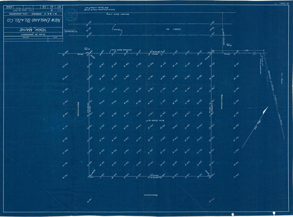
85 Map Output Page 1 of 1 2/7/2013 Town of York Maine Geographic Information System ME Lot 2 My Map Subject Property Data Old Parcel ID New Parcel ID Owner NO N E TELEPHONE OPERATIONS LLC Prop Location 61 FERRY LANE SOUTH Co Owner Owner Addr PO BOX 1509 Owner City BANGOR, ME Land Area Land Value Building Value 0 Total Value Use Code 430V Sale Date Sale Price 0 Qualified Sale U Book/Page 15386/ 134 Disclaimer The Town of York makes no warranty or representation as to the accuracy, timeliness or completeness of any of the data. The Town of York shall have no liability for the data or lack thereof, or any decision made or action taken or not taken in reliance upon any of the data.
86 Print Summary Page 1 of 2 2/6/2013 No Image Powered by Vision Government Solutions, Inc. MBLU : 0067/ 0006/ / / / Location: 61 FERRY LANE SOUTH Owner Name: NO N E TELEPHONE OPERATIONS LLC Account Number: Parcel Value Item Assessed Value Buildings 0 Xtra Bldg Features 0 Outbuildings 0 Land 71,100 Total: 71,100 Owner of Record NO N E TELEPHONE OPERATIONS LLC PO BOX 1509 BANGOR, ME Ownership History Owner Name Book/Page Sale Date Sale Price NO N E TELEPHONE OPERATIONS LLC 15386/ 134 3/27/ NEW ENGLAND TEL AND TEL CO 1/ 1 1/1/ Land Use Land Use Code 430V Land Use Description TEL X STA MDL-00 Land Line Valuation Size Assessed Value 0.23 AC 71,100 Construction Detail Building # 1 STYLE Vacant Land MODEL Vacant Building Valuation Living Area: 0 square feet Replacement Cost: 0 Year Built: Building Value: 0
87 Print Summary Page 2 of 2 2/6/2013 Extra Features Code Description Units No Extra Building Features Outbuildings Code Description Units TELB TPHONE BLDG SV 1 UNITS Building Sketch Vacant Land, No Sketch
88
89
90
91
92
93
94
95
96
Owner: Sharon Hackett. Property: 2498 SE Mullenix Road Port Orchard, WA Provided Especially For:
 Owner: Sharon Hackett Property: 2498 SE Mullenix Road Port Orchard, WA 98367 242301-4-019-2001 Provided Especially For: Danny Horovitz John L. Scott Real Estate Silverdale, WA We are pleased to provide
10/21/2016 Geauga County Auditors Office REALink
 10/21/2016 Geauga County Auditors Office REALink New Search Parcel Number Location Address Owner Name Acres 02 421302 9205 STAFFORD RD GOFORTH TRACEY MARIE & WELTLICH SHANNON 10.07 Main Information Map
Sales Date Grantor Convey No. Convey Typ # Parcels Sales Price
 Owner Name LOHR DONNA L LOHR DONNA L Prop. Class Land Use R - Residential 550 - CONDOMINIUM UNIT Site Address LegalDescriptions 4714 MERRIFIELD PL BRANFORD VILLAGE CONDOMINIUM BLDG 15 UNIT 70 Tax District
Sales Date Grantor Convey No. Convey Typ # Parcels Sales Price
 Owner Name FINDLEY FRANK A Prop. Class Land Use C - Commercial 471 - DWELLING CONVERTED TO Site Address LegalDescriptions 2584 BRIGGS RD 2584 BRIGGS RD LOT 89 BLK 2 EUREKA PARK Tax District Sch. District
Summary of Legal Descriptions
 Perimeter Descriptions Bounds Descriptions - perimeter descriptions without a direction of travel. Metes Descriptions - perimeter descriptions with a direction of travel described by a series of measurements.
CITY OF PAPILLION PLANNING COMMISSION STAFF REPORT MAY 27, 2015 AGENDA 2015 ANNEXATION MISC
 PLANNING COMMISSION STAFF REPORT MAY 27, 2015 AGENDA 2015 ANNEXATION MISC-15-0005 I. GENERAL INFORMATION A. APPLICANT: City of Papillion 122 East Third St. Papillion, NE 68046 B. LEGAL DESCRIPTION: See
BUILDING AND SAFETY FEE SCHEDULE (Effective July1, 2013)
") BUILDING AND SAFETY DIVISION TELEPHONE (949) 724-6300 BUILDING AND SAFETY FEE SCHEDULE (Effective July1, 2013) Payment: When a plan is required by the Administrative Authority to be submitted, a plan check
BUILDING AND SAFETY DIVISION TELEPHONE (949) 724-6300 BUILDING AND SAFETY FEE SCHEDULE (Effective July1, 2013) Payment: When a plan is required by the Administrative Authority to be submitted, a plan check
Deschutes County Property Information
 Deschutes County Property Information Report Date: 1/25/2015 3:11:23 PM Disclaimer The information and maps presented in this report are provided for your convenience. Every reasonable effort has been
GIS SERVICE CENTER MAP ORDER FORM
 Steven V. Stenger County Executive Pam Reitz Director of Administration GIS SERVICE CENTER MAP ORDER FORM 1. Print this form. 2. Fill out the form calculate and include the total cost of your order. 3.
VIKING INSPECTION PROPERTY 4921 U.S. Hwy. 85, Williston, ND 58801
 SALE PRICE: $799,000 LOT SIZE: +/-2.49 Acres BUILDING SIZE: +/-3,800 SF DRIVE-IN DOORS 2 CEILING HEIGHT: 16' YEAR BUILT: 2007 ZONING: Commercial PROPERTY OVERVIEW Highly visible, hard-to-find small shop/office/apartment
Engineer's Report. Main Street Business Area. Festoon Lighting and Sidewalk Cleaning Assessment District (Fiscal Year )
") Engineer's Report for the Main Street Business Area Festoon Lighting and Sidewalk Cleaning Assessment District (Fiscal Year 2008-09) Prepared under the provisions of the Benefit Assessment Act of 1982
Engineer's Report for the Main Street Business Area Festoon Lighting and Sidewalk Cleaning Assessment District (Fiscal Year 2008-09) Prepared under the provisions of the Benefit Assessment Act of 1982
FINAL PROJECT PLAN TAX INCREMENT DISTRICT #66 MORNINGSTAR. Prepared by the
 PROJECT PLAN TAX INCREMENT DISTRICT #66 MORNINGSTAR Prepared by the Rapid City Growth Management Department January 17, 2008 INTRODUCTION Tax Increment Financing is a method of financing improvements and
 Boone County GIS has the right to inquire about and investigate the use of any requested products and deny access to anyone based on concerns relating to privacy, security, public health, public safety,
Write a report (6-7 pages, double space) on some examples of Internet Applications. You can choose only ONE of the following application areas:
 on some examples of Internet Applications. You can choose only ONE of the following application areas:") UPR 6905 Internet GIS Homework 1 Yong Hong Guo September 9, 2008 Write a report (6-7 pages, double space) on some examples of Internet Applications. You can choose only ONE of the following application
UPR 6905 Internet GIS Homework 1 Yong Hong Guo September 9, 2008 Write a report (6-7 pages, double space) on some examples of Internet Applications. You can choose only ONE of the following application
REQUEST FOR PROPOSALS CLOSING DATE:
 Request for Proposals 110 Westlake Drive City of West Lake Hills 110 Westlake Drive REQUEST FOR PROPOSALS CLOSING DATE: Tuesday, October 23, 2018 City of West Lake Hills Request for Proposals 1 I. INTRODUCTION
Chapter 1 Homework - Elements of Real Estate Law
 Chapter 1 Homework - Elements of Real Estate Law The following questions are a small example of what you might expect to see on the Real Estate Law portion of the Cadastral Mapping exam. First try answering
Proclaiming Certain Lands as Reservation for the Confederated Tribes of the
 This document is scheduled to be published in the Federal Register on 11/05/2018 and available online at https://federalregister.gov/d/2018-24174, and on govinfo.gov [4337-15] DEPARTMENT OF THE INTERIOR
I-94 COMMERCIAL LAND ±30.44 ACRES TH ST Eau Galle, WI 54747
 PROPERTY HIGHLIGHTS + + Located off I-94 and Hwy 63 Interchange 2,900 VPD + + Baldwin-Woodville Area School District + + Zoning: Commercial, Rural Residential + + 40 miles to St. Paul + + 25 miles to Menomonie,
TREASURE COAST REGIONAL PLANNING COUNCIL M E M O R A N D U M. To: Council Members AGENDA ITEM 4B10
 TREASURE COAST REGIONAL PLANNING COUNCIL M E M O R A N D U M To: Council Members AGENDA ITEM 4B10 From: Date: Subject: Staff December 14, 2018 Council Meeting Local Government Comprehensive Plan Review
NRPC GIS BROWNBAG SERIES. Monday, October 7, 13
 NRPC GIS BROWNBAG SERIES NRPC GIS BROWNBAG SERIES NEW HAMPSHIRE MOSAIC PARCEL DRIVEN DECISION MAKING David Salzer PEOPLE WANT MAPS APPLE MAPS? APPLE MAPS? NO THANKS! GOOGLE MAPS? GOOGLE MAPS? YES PLEASE!
TAX ROLL FOR CITY OF RICHMOND IN THE COUNTY OF, MI FOR THE YEAR 2017 Spec. Population: Ad Valorem+Special Acts
 1/7 Parcel # Valuations Tax Heading Amount Tax Heading Amount --- Totals --- PARCEL #: 7405-006-1001-000 CLASS: 201 SUMMER TAX HEADING AMOUNT WINTER TAX HEADING AMOUNT SUM TAX 4,063.84 SCHOOL: 50180 05
Using West Virginia GeoExplorer's Historical Gazetteer Feature
 Using West Virginia GeoExplorer's Historical Gazetteer Feature gaz - et - teer: a geographical index or dictionary This Historical Gazetteer is a geographical database of place names found in historical
Current Functions (Enter categories from instructions) Materials (Enter categories from instructions)
 Materials (Enter categories from instructions)") Site Inventory Form State Inventory No. 92-00490 New Supplemental State Historical Society of Iowa Part of a district with known boundaries (enter inventory no.) 92-00349 (November 2005) Relationship:
Site Inventory Form State Inventory No. 92-00490 New Supplemental State Historical Society of Iowa Part of a district with known boundaries (enter inventory no.) 92-00349 (November 2005) Relationship:
TRACT 7: ±252 Acres Irrigated Farmland Grassland
 TRACT 7: ±252 Acres Irrigated Farmland Grassland 1880 FM 2013, Friona, Texas 79035 ±252 acres of irrigated farmland and grassland. This farmland is currently being leased and farmed. The lease agreement
Developing a Subdivision Build- Out Study and Site Suitability Tool; Enabling Access Through a Web GIS Application
 Developing a Subdivision Build- Out Study and Site Suitability Tool; Enabling Access Through a Web GIS Application DOUG SEXTON GEOG 596A SUMMER 2017 ADVISOR: DR. JAMES O BRIEN Project Outline Introduction
Coyote Creek Apache County, Arizona
 Coyote Creek Apache County, Arizona Listed for sale exclusively by: Traegen Knight Headquarters West Ltd. PO BOX 1980 St. Johns, AZ 85936 Phone: (928) 524-3740, Fax: (928) 563-7004, Cell: (602) 228-3494
ATTACHMENT A. Item #1 Minimum Bid: $3, Parcel No Assessed Value: $10,000 Acreage: 0
 ATTACHMENT A Item #1 Minimum Bid: $3,634.59 Parcel No. 0610540500 Assessed Value: $10,000 Acreage: 0 Lots 5 and 6, Block 54, Town of Coulee Dam, Washington, according to the Second Revised Okanogan County
AGENDA CLAYTON BOARD OF ADJUSTMENT
 AGENDA CLAYTON BOARD OF ADJUSTMENT APRIL 15, 2015 6:00 P.M. CLAYTON TOWN HALL 111 East Second Street, Clayton NC I. ROLL CALL II. III. IV. ANNOUNCEMENT OF QUORUM / VOTING MEMBERS ADJUSTMENTS TO AGENDA
Annual TTFO Meeting April 10, 2018 Michael J. Wittman, P.S. Chief Surveyor / GIS Coordinator
 Annual TTFO Meeting April 10, 2018 Michael J. Wittman, P.S. Chief Surveyor / GIS Coordinator Text Book Definition: Layman Terms: An organized collection of hardware, software and geographic data designed
Historic Cultural Properties Inventory (HCPI) Base Form (FORM 1)
 Base Form (FORM 1)") Historic Cultural Properties Inventory (HCPI) Base Form (FORM 1) Historic Preservation Division, New Mexico Office of Cultural Affairs For HPD Office use only: HCPI No. District No. NRHP: SRCP: Criteria:
Historic Cultural Properties Inventory (HCPI) Base Form (FORM 1) Historic Preservation Division, New Mexico Office of Cultural Affairs For HPD Office use only: HCPI No. District No. NRHP: SRCP: Criteria:
FOR SALE. Chapel Lane, West Ella, East Yorkshire, HU10 7SE RESIDENTIAL CONVERSION AND NEW BUILD OPPORTUNITY
 Chapel Lane, West Ella, East Yorkshire, HU10 7SE FOR SALE RESIDENTIAL CONVERSION AND NEW BUILD OPPORTUNITY Conversion, extension and adaptation of former chapel to form a detached three bedroom dwelling
TOWN OF ELLERY RESIDENTIAL VALID SALES RESIDENTIAL SALES FROM JANUARY 1, 2007 TO DECEMBER 30, 2010
 TOWN OF ELLERY RESIDENTIAL VALID SALES RESIDENTIAL SALES FROM JANUARY 1, 2007 TO DECEMBER 30, 2010 The information included in this report was printed as of February 23, 2011 The information contained
GIS Monroe Geographic Information System March 14, 2018
 GIS Monroe Geographic Information System March 14, 2018 Goals Maintain Enterprise/County-wide geo-database Increase spatial accuracy of data Build and acquire more data layers Increase use of GIS; as another
Article 11: Relating to Taxation Excise on Motor Vehicles and Trailers
 Article 11: Relating to Taxation Excise on Motor Vehicles and Trailers Article 11 uses four levers to decrease the motor vehicle excise tax each year from FY2018 through FY2023, fully eliminating the tax
APPLICATION TO AMEND THE FUTURE LAND USE MAP (FLUM) SMALL SCALE
 SMALL SCALE") DEPARTMENT OF DEVELOPMENT & PLANNING 825 Ohio Avenue - Lynn Haven, FL 32444 (850) 265-2961 - (850) 265-3478 APPLICATION TO AMEND THE FUTURE LAND USE MAP (FLUM) SMALL SCALE Deadline to submit is 30 days
DEPARTMENT OF DEVELOPMENT & PLANNING 825 Ohio Avenue - Lynn Haven, FL 32444 (850) 265-2961 - (850) 265-3478 APPLICATION TO AMEND THE FUTURE LAND USE MAP (FLUM) SMALL SCALE Deadline to submit is 30 days
Case study: Nairobi City County CBD and its Environs. Presenter: Peter Patrick Kioko. Supervisor: Mr. B.M. Okumu
 Case study: Nairobi City County CBD and its Environs Presenter: Peter Patrick Kioko Supervisor: Mr. B.M. Okumu OUTLINE Introduction Problem Statement Objectives Area of study Application of GIS Methodology
Week 3: The Urban Housing Market, Structures and Density.
 Week 3: The Urban Housing Market, Structures and Density. Hedonic Regression Analysis. Shadow prices versus marginal costs. Land value maximizing FAR. FAR and Urban Redevelopment. Land Use competition:
Jernigans Mobile Home Community 103 Spring Street, Grovetown, GA 30813
 EXECUTIVE SUMMARY OFFERING SUMMARY Sale Price: $600,000 Number Of Units: 21 Cap Rate: 9.4% NOI: $66,895 Lot Size: 2.7 Acres Building Size: 23,000 PROPERTY OVERVIEW 21 Space park. All units are park owned
Comptroller GIS and Property Data. Ken Morrell Assessment Systems Manager Division of Property Assessments February 22, 2007
 Comptroller GIS and Property Data Ken Morrell Assessment Systems Manager Division of Property Assessments February 22, 2007 Comptroller Divisions Using and Supporting GIS Office of Local Government Implement
E-Community Check Request Checklist
 E-Community Check Request Checklist The E-Community must complete the following information on each business approved for a loan or grant in order for the Kansas Center of Entrepreneurship (KCFE) to disburse
PUP R-4 R-3 R-4 R-3 R-4 B-1 B-3 B-1 B-1 B-1 R-3 C-1 R-3 R-3 A-1 M-2C SUBJECT PROPERTY B-3 R-5 B-3C B-3C B-3C B-3C B-2.
 0 0 0 0 0 00 0 EARLY AVE 00 0 0 0 0 0 R- 0 0 0 C- 0 0 0 0 0 0 R- 0 B- 00 0 0 0 0 0 0 CARTER AVE EAST SIDE LN 0 0 0 JACKSON AVE 00 0 0 A- Parcels or Portions thereof identified on this sheet are within
NOTICES OF SHERIFF'S SALE
 Updated: 04/11/19 at 1:12 AM NOTICES OF SHERIFF'S SALE Date & Time of Sale: Thu, Mar 14, 2019 at 1:00 pm Sheriff Sale File number: 87-19-0016-SS Judgment to be Satisfied: $139,685.32 Cause Number: 87C01-1404-MF-000584
TOWN OF SEVERANCE, COLORADO. NOTICE OF PUBLIC HEARINGS FOR A PROJECT Hunters Crossing Annexation & Zoning
 TOWN OF SEVERANCE, COLORADO NOTICE OF PUBLIC HEARINGS FOR A PROJECT Hunters Crossing Annexation & Zoning NOTICE IS HEREBY GIVEN that the Public Hearing required by C.R.S. 31-12-108 before the Severance
Digital Tax Maps Westport Island Project Summary
 Digital Tax Maps Westport Island Project Summary Presented to the: Mid-Coast Regional Planning Commission Creating GIS-Based Digital Tax Maps And Linked Assessment Records For Small Towns on a Budget Dennis
 https://www.bpofulfillment.com/.aspx?control=findbpo&assetid=&orderid=2005494 1h : 59m : 54s Order : Inspection Date: 11 / 02 / 2013 Information Source: Tax data Property Type: SFD APN (Tax ID number):
Kenneth Shelton, Assistant Superintendent, Business Services Los Angeles County Office of Education 9300 Imperial Highway Downey, CA 90242
 April 17, 2009 Kenneth Shelton, Assistant Superintendent, Business Services Los Angeles County Office of Education 9300 Imperial Highway Downey, CA 90242 Dear Assistant Superintendent Shelton: The purpose
Alamito Creek Preserve Ranches for Sale Marfa, Presidio County, Texas
 Alamito Creek Preserve Ranches for Sale Marfa, Presidio County, Texas James King, Agent Office 432 426.2024 Cell 432 386.2821 James@KingLandWater.com Alamito Creek Preserve Various size Ranch Properties,
Frequently Asked Questions about MnDOT s Railroad Map Conversion Project
 Frequently Asked Questions about MnDOT s Railroad Map Conversion Project What were the main objectives of the project? What are the results and end products? What can these railroad maps be used for? Who
Current Functions (Enter categories from instructions) 02G04: Commerce/Trade - tavern 14D09: Transportation automotive service
 02G04: Commerce/Trade - tavern 14D09: Transportation automotive service") Site Inventory Form State Inventory No. 29-03500 New Supplemental State Historical Society of Iowa Part of a district with known boundaries (enter inventory no.) 29-03522 (November 2005) Relationship:
Site Inventory Form State Inventory No. 29-03500 New Supplemental State Historical Society of Iowa Part of a district with known boundaries (enter inventory no.) 29-03522 (November 2005) Relationship:
Sample Snow Services Proposal Alle Rorie 7157 E Kemper Rd Cincinnati, OH Phone: (800)
") Sample Snow Services Proposal Alle Rorie 7157 E Kemper Rd Cincinnati, OH 45249 Phone: (800) 280-5153 Email: goisales@gisdynamics.com Service Address Corporate America Jim Smith 1 Corporate Way Cincinnati,
Sample Snow Services Proposal Alle Rorie 7157 E Kemper Rd Cincinnati, OH 45249 Phone: (800) 280-5153 Email: goisales@gisdynamics.com Service Address Corporate America Jim Smith 1 Corporate Way Cincinnati,
Lakeland Court MHP Norton Rd Lakeland, FL 33809
 23-space/units - 2 Block Homes - 2 Duplexes 75% Occupied - Annual Leases - Long Term Tenants City Water - Septic Possible 3 additional spaces can be added Seller may consider offering Seller Financing
UTILITY REPORT FOR THORNTON SELF STORAGE THORNTON, COLORADO
 UTILITY REPORT FOR THORNTON SELF STORAGE THORNTON, COLORADO Prepared by: Bowman Consulting 63 Park Point Dr. Suite 1 Golden, CO 841 (33)-81-29 June 29, 215 Revised August 14, 215 Revised September 3, 215
CHAPTER 5 DOWNTOWN DEVELOPMENT AUTHORITY
 CHAPTER 5 DOWNTOWN DEVELOPMENT AUTHORITY Sec. 5-1. Purposes. Sec. 5-2. Definitions. Sec. 5-3. Determination of Necessity. Sec. 5-4. Establishment; Title. Sec. 5-5. Ordinance approving development plan
BEFORE THE BOARD OF COUNTY COMMISSIONERS OF LANE COUNTY, OREGON
 BEFORE THE BOARD OF COUNTY COMMISSIONERS OF LANE COUNTY, OREGON ORDER NO. 18-04-10-06 IN THE MATTER OF SETTING A PUBLIC HEARING FOR THE PROPOSED SURRENDER OF A PORTION OF COAST GUARD STATION ROAD (COUNTY
Jo Daviess County Geographic Information System
 Introduction The Jo Daviess County Geographic Information System (GIS) offers a wide variety of products and services. The GIS program has a cost recovery policy in place to help maintain and continue
EXHIBIT H LOT 317 GRADING AND SITE PLAN
 EXHIBIT H LOT 317 GRADING AND SITE PLAN EXHIBIT I LOT 317 ELEVATIONS ridge height 4915'-6" GENERAL & KEYED NOTES ridge height 4905'-9" 3 7 4 A5.1 1 5 ridge height 4910'-6" 2 ridge height 4906'-3" 1 Provide
MATH FOR LIBERAL ARTS FINAL REVIEW
 MATH FOR LIBERAL ARTS FINAL REVIEW Find the value of the annuity. Round to the nearest cent. A = P 1 + r n r n nt - 1 P = A r n 1 + r n nt - 1 1) Periodic Deposit: $100 at the end of each year Rate: 5%
BROWN COUNTY FARMLAND AUCTION
 BROWN COUNTY FARMLAND AUCTION CROP - PASTURE - HUNTING - INVESTMENT 62 Acres +/- TUESDAY, NOVEMBER, 1 :30am Auction Location: The DEC (Dakota Event Center) - Lamont St. - Aberdeen, SD 5401 Mercier & Ravina
Lake Township Proposed Budget Fiscal Year
 Fiscal Year Apriil 1, 2017 through March 31, 2018 Tentative Taxable Value for 2017 Tax Spread General Operating Millage Subject to Headlee Rollback Extra Voted Millage Rate Subject to Headlee Rollback
GEO-INFORMATICS AND SPACE TECHNOLOGY FOR PROPERTIES DIGITAL TAX MAP : CASE STUDY ON LOCAL ADMINISTRATIVE WONG KONG MUNICIPALITY, PHITSANULOK, THAILAND
 GEO-INFORMATICS AND SPACE TECHNOLOGY FOR PROPERTIES DIGITAL TAX MAP : CASE STUDY ON LOCAL ADMINISTRATIVE WONG KONG MUNICIPALITY, PHITSANULOK, THAILAND Vicharn Amarakul Regional Center of Geo-Informatics
Historic Cultural Properties Inventory (HCPI) Base Form (FORM 1)
 Base Form (FORM 1)") Historic Cultural Properties Inventory (HCPI) Base Form (FORM 1) Historic Preservation Division, New Mexico Office of Cultural Affairs For HPD Office use only: HCPI No. District No. NRHP: SRCP: Criteria:
Historic Cultural Properties Inventory (HCPI) Base Form (FORM 1) Historic Preservation Division, New Mexico Office of Cultural Affairs For HPD Office use only: HCPI No. District No. NRHP: SRCP: Criteria:
VILLAGE OF ORLAND PARK
 14700 Ravinia Avenue Orland Park, IL 60462 www.orland-park.il.us Ordinance No: File Number: 2013-0373 AN ORDINANCE ESTABLISHING SPECIAL SERVICE AREA NUMBER 3 STATE OF ILLINOIS, COUNTIES OF COOK AND WILL
FLORIDA INVENTORY OF SCHOOL HOUSES (FISH)
") ORGANIZATION: FACILITY: FACILITY USE: 51-PASCO COUNTY SCHOOL DISTRICT SOUTHEAST BUS GARAGE ALL DISTRICT: 51 PASCO COUNTY SCHOOL DISTRICT FACILITY: 55-F SOUTHEAST BUS GARAGE Primary Use: TRANSPORTATION
ORGANIZATION: FACILITY: FACILITY USE: 51-PASCO COUNTY SCHOOL DISTRICT SOUTHEAST BUS GARAGE ALL DISTRICT: 51 PASCO COUNTY SCHOOL DISTRICT FACILITY: 55-F SOUTHEAST BUS GARAGE Primary Use: TRANSPORTATION
REO 100% Leased Four (4) Unit Mixed-Use Property Along Ashland
 Unit Mixed-Use Property Along Ashland") 5015 SOUTH ASHLAND AVENUE CHICAGO, IL 60609 DETAILS Sale Price $119,000 Lot Size 0.06 Acres Building Size 3,784 SF Occupancy 100% Year Built 1893 Market Cook County Sub Market South Chicago Cross Streets
5015 SOUTH ASHLAND AVENUE CHICAGO, IL 60609 DETAILS Sale Price $119,000 Lot Size 0.06 Acres Building Size 3,784 SF Occupancy 100% Year Built 1893 Market Cook County Sub Market South Chicago Cross Streets
KING GEORGE COUNTY DEPARTMENT OF COMMUNITY DEVELOPMENT
 GIS REPORT 2016 KING GEORGE COUNTY DEPARTMENT OF COMMUNITY DEVELOPMENT Background The GIS (Geographic Information System) coordinator was hired in 2001 to develop a GIS for King George County. Prior to
WHEREAS, a zoning district map and legaldescription for the subject property are provided in Ordinance Exhibits A and B, respectively; and
 ORDINANCE NO S.907. AN ORDINANCE AMENDING ORDINANCE NO 4441, WHICH ADOPTED THE CITY OF ALBANY ZONING MAP, BY AMENDING THE ALBANY ZONING MAP AND ADOPTING FINDINGS FOR UNADDRESSED PARCELS, LINN COUNTY ASSESSOR'
Name of Applicant Mailing Address address Telephone Number
 District Court, Water Division, Colorado Court Address: CONCERNING THE APPLICATION FOR WATER RIGHTS OF Applicant: In the River or its Tributaries In COUNTY Attorney or Party Without Attorney (Name and
TOWNSHIP OF SCHUYUULL COUNTY OF SCRUYLMLL RESOLUTIONS ADOPTED 7.9 RESOLUTION
 TOWNSHIP OF SCHUYUULL COUNTY OF SCRUYLMLL RESOLUTIONS ADOPTED 7.9, 1999 RESOLUTION C/9.3, DECLARING ThE INTENT OF THE TOWNSHIP OF SCHUYLKILL THAT THE PORTION OF UMON STREET ADJACENT TO THE PROPERTY OF
TOWN OF CHATHAM LAND BANK
 TOWN OF CHATHAM LAND BANK 1998-2007 TALLY 16 PROJECTS COMPLETED 162 ACRES ACQUIRED TOTAL PURCHASE PRICES: NON-TOWN FUNDING: NET LAND BANK COST: $12,768,800 $ 1,71,214 $10,737,586 TOTAL COST PER ACRE: $78,820
Technical Memorandum #2 Future Conditions
 Technical Memorandum #2 Future Conditions To: Dan Farnsworth Transportation Planner Fargo-Moorhead Metro Council of Governments From: Rick Gunderson, PE Josh Hinds PE, PTOE Houston Engineering, Inc. Subject:
McHenry County Property Search Sources of Information
 Disclaimer: The information in this system may contain inaccuracies or typographical errors. The information in this system is a digital representation of information derived from original documents; as
Systems. Department Mission: Mandated Services: Department Overview: Successes and Challenges:
 Department: Geographic Information Systems FY 2018 Proposed Budget Department Mission: The mission of the Klamath County Geographic Information Systems (GIS) department is to provide maintenance of and
Sunshine City 47-Sp MHP
 Sunshine City 47-Sp MHP 47-sp MHP w/36 POM's Recreation Building used for StorageLaundry Room (Currently not in use) 70% Occupancy - 9-spaces left & 5 MH's left to lease 10 Mobile Homes Newly Rehabbed
Villages at Riverdale Thornton, CO
 FINAL UTILITY REPORT Villages at Riverdale Thornton, CO October 14, 216 Revised: March 29, 217 JN: 1539 Prepared for: PCS Group, Inc. 11 16 th Street #3 B-18 Denver, CO 8265 P: 33.531.495 Prepared by:
Residential Demographic Multipliers
 Rutgers University, Center for Urban Policy Research Residential Demographic Multipliers Estimates of the Occupants of New Housing (Residents, School-Age Children, Public School-Age Children) by State,
WHITEHEAD 30 (10) (570) (30) (10) & TRACY MILLER.
 (570) (30) (10) & TRACY MILLER.") BEGINNING at a point in the center of Pennsylvania State Highway Route No. 414, said point located on the boundary between the lands herein described and lands now or formerly of Carman Tartaglia; thence
BEGINNING at a point in the center of Pennsylvania State Highway Route No. 414, said point located on the boundary between the lands herein described and lands now or formerly of Carman Tartaglia; thence
For Sale on Bids. Open House By Appointment
 For Sale on Bids Written Bid Deadline: Friday, September 7, by 12:00 P.M. Noon 52+/- Acres & Storage Facility Grand Forks, ND Property Location: Conveniently located off Interstate 29 and North Washington
Map and Atlas Collection
 Finding aid prepared by Jillian Fuller This finding aid was produced using the Archivists' Toolkit June 12, 2014 Describing Archives: A Content Standard Ida Public Library May 10, 2014 320 N. State St.
Inception to Completion: The Project Design Workflow. Southwest User Group April 10, 2018 Broomfield, CO
 1 Inception to Completion: The Project Design Workflow Southwest User Group April 10, 2018 Broomfield, CO 2 Tools Trimble GPS Survey grade (S6) Mapping grade (6000) Trimble V10 imaging rover Trimble Business
CAPRON TRAIL COMMUNITY DEVELOPMENT DISTRICT
 CAPRON TRAIL COMMUNITY DEVELOPMENT DISTRICT ST. LUCIE COUNTY REGULAR BOARD MEETING & PUBLIC HEARING AUGUST 28, 2017 1:30 P.M. Special District Services, Inc. The Oaks Center 2501A Burns Road Palm Beach
National Register of Historic Places Registration Form
 United States Department of the Interior National Park Service National Register of Historic Places Registration Form This form is for use in nominating or requesting determinations for individual properties
COUNTY OF SONOMA PERMIT AND RESOURCE MANAGEMENT DEPARTMENT 2550 Ventura Avenue, Santa Rosa, CA (707) FAX (707)
 FAX (707)") COUNTY OF SONOMA PERMIT AND RESOURCE MANAGEMENT DEPARTMENT 2550 Ventura Avenue, Santa Rosa, CA 95403 (707) 565-1900 FAX (707) 565-1103 DATE : TO: FROM: SUBJECT: July 21, 2009 at 2:30 p.m. Board of Supervisors
COUNTY OF SONOMA PERMIT AND RESOURCE MANAGEMENT DEPARTMENT 2550 Ventura Avenue, Santa Rosa, CA 95403 (707) 565-1900 FAX (707) 565-1103 DATE : TO: FROM: SUBJECT: July 21, 2009 at 2:30 p.m. Board of Supervisors
CAPTAIN S KEY DEPENDENT DISTRICT PALM BEACH COUNTY REGULAR BOARD MEETING MAY 8, :00 P.M.
 CAPTAIN S KEY DEPENDENT DISTRICT PALM BEACH COUNTY REGULAR BOARD MEETING MAY 8, 2018 6:00 P.M. Special District Services, Inc. The Oaks Center 2501A Burns Road Palm Beach Gardens, FL 33410 www.captainskeydd.org
APPLICATION FOR CONDITIONAL ABSOLUTE WATER STORAGE RIGHT
 District Court, Water Division, Colorado Court Address: CONCERNING THE APPLICATION FOR WATER RIGHTS OF Applicant: In the River or its Tributaries In COUNTY Attorney or Party Without Attorney (Name and
IGIC Cadastral, Boundaries, PLSS Workgroup
 IGIC Cadastral, Boundaries, PLSS Workgroup IGIC Workgroup Comments and suggestions welcome Lorraine Wright (Chair) Indiana Department of Environmental Management Office of Land Quality Science Services
PLANNING COMMISSION AGENDA
 COUNTY OF IMPERIAL COMMISSIONERS: Chairman: Rudy Schaffner Dennis Bergh Norm Niver Vice Chairman: Carson Kalin Sergio Cabanas Russell Roben Max Castillo Carlton A. Hargrave Ernesto Medina JIM MINNICK,
APPENDIX 1 LITTLE EGYPT FROM THE AIR
 APPENDIX 1 LITTLE EGYPT FROM THE AIR FIGURE 1. In this 1930 City of Dallas aerial photo, the land surrounding Little Egypt is seen as cultivated fields and agricultural structures. The Hill property is
Make all changes on real property, due to ownership changes, from all recorded deeds, by maintaining cadastral mapping records.
 Department: Geographic Information Systems FY 2017 Proposed Budget Department Mission: The mission of the Klamath County Geographic Information Systems (GIS) department is to provide maintenance of and
SEWER FUND BUDGET BYLAW
 SEWER FUND BUDGET BYLAW CITY OF PARKSVILLE 2018-2022 Final Financial Plan Sewer Utility Fund Budget Bylaw Funding Sources 2018 2019 2020 2021 2022 Sewer Parcel Taxes $ 29,300 $ 30,179 $ 31,084 $ 32,016
Remote Sensing the Urban Landscape
 Remote Sensing the Urban Landscape Urban landscape are composed of a diverse assemblage of materials (concrete, asphalt, metal, plastic, shingles, glass, water, grass, shrubbery, trees, and soil) arranged
PERSONAL REAL ESTATE CORPORATION Comox Valley Home Sales for the month of June, 2018 (Single Family) MB - Merville/Black Creek Sales Avg Sale Price 1
 MB - Merville/Black Creek Sales Avg Sale Price 1") PERSONAL REAL ESTATE CORPORATION Comox Valley Home Sales for the month of June, 2018 (Single Family) MB - Merville/Black Creek 1 $630,000 MW - Mt. Washington 1 $407,000 CN - Courtenay North 0 CP - Comox
PERSONAL REAL ESTATE CORPORATION Comox Valley Home Sales for the month of June, 2018 (Single Family) MB - Merville/Black Creek 1 $630,000 MW - Mt. Washington 1 $407,000 CN - Courtenay North 0 CP - Comox
VILLAGE OF ORLAND PARK
 14700 Ravinia Avenue Orland Park, IL 60462 www.orland-park.il.us Ordinance No: File Number: 2013-0239 AN ORDINANCE PROPOSING THE ESTABLISHMENT OF SPECIAL SERVICE AREA NUMBER 2 IN THE, AND PROVIDING FOR
Ottumwa Schafer Stadium 8-Lane Track BIDS RECEIVED AT: OTTUMWA COMMUNITY SCHOOL DISTRICT OFFICE 1112 N. VAN BUREN OTTUMWA, IOWA 52501
 REISSUED 10/09/2017 SECTION 001116 ADVERTISEMENT FOR BIDS 1. Sealed bids will be received by Ottumwa Community School District for construction of the following: Ottumwa Schafer Stadium 8-Lane Track Bids
NOISE IMPACT ASSESSMENT 114 ISABELLA STREET RESIDENTIAL DEVELOPMENT OTTAWA, ONTARIO
 Smart Property Advisors Ltd. 802-500 Laurier Avenue West Ottawa, ON NOISE IMPACT ASSESSMENT 114 ISABELLA STREET RESIDENTIAL DEVELOPMENT OTTAWA, ONTARIO Prepared by: SMART PROPERTY ADVISORS LTD. 802 500
Independent Accountant's Compilation Report
 MILLER, BRUSSELL, EBBEN AND GLAESKE LLC CERTIFIED PUBLIC ACCOUNTANTS POST OFFICE BOX 585 PORTAGE, WISCONSIN 53901 Independent Accountant's Compilation Report Saddle Ridge Association Ltd A Wisconsin Homeowners
GIS and Web Technologies to Improve Irrigation Districts
 GIS and Web Technologies to Improve Irrigation Districts Presented To: Montana Association of Dam and Canal Systems Workshop Presented By: Brian Fischer, CFM GIS Manager October 07, 2010 What you won t
Commonwealth of Massachusetts Massachusetts Historical Commission 220 Morrissey Boulevard, Boston, Massachusetts
 Inventory No: Historic Name: HRV.102 Shaker Tailor Shop Common Name: Address: 88 Shaker Rd City/Town: Village/Neighborhood: Harvard Shaker Village Local No: 5-22; 9; 93; 5-E Year Constructed: Architect(s):
CONGLETON INDUSTRIAL PARK LT 6 EX W 300' & E 350' LT 7 BLK 1, a subdivision of land in the City of Overland Park, Johnson County, Kansas.
 NOTICE OF PUBLIC HEARING CITY PLANNING COMMISSION CITY OF OVERLAND PARK, KANSAS Notice is hereby given that the City Planning Commission of Overland Park, Kansas, will hold a public hearing Monday, July
FLORIDA INVENTORY OF SCHOOL HOUSES (FISH)
") ORGANIZATION: FACILITY: FACILITY USE: 35-LAKE COUNTY SCHOOL DISTRICT UMATILLA MIDDLE ALL DISTRICT: 35 LAKE COUNTY SCHOOL DISTRICT FACILITY: 41-A UMATILLA MIDDLE Primary Use: MIDDLE Grades Housed: 06-08
ORGANIZATION: FACILITY: FACILITY USE: 35-LAKE COUNTY SCHOOL DISTRICT UMATILLA MIDDLE ALL DISTRICT: 35 LAKE COUNTY SCHOOL DISTRICT FACILITY: 41-A UMATILLA MIDDLE Primary Use: MIDDLE Grades Housed: 06-08
Historic Cultural Properties Inventory (HCPI) Base Form (FORM 1)
 Base Form (FORM 1)") Historic Cultural Properties Inventory (HCPI) Base Form (FORM 1) Historic Preservation Division, New Mexico Office of Cultural Affairs For HPD Office use only: HCPI No. District No. NRHP: SRCP: Criteria:
Historic Cultural Properties Inventory (HCPI) Base Form (FORM 1) Historic Preservation Division, New Mexico Office of Cultural Affairs For HPD Office use only: HCPI No. District No. NRHP: SRCP: Criteria: