IGIC Cadastral, Boundaries, PLSS Workgroup
|
|
|
- Shauna Townsend
- 5 years ago
- Views:
Transcription
1 IGIC Cadastral, Boundaries, PLSS Workgroup IGIC Workgroup Comments and suggestions welcome Lorraine Wright (Chair) Indiana Department of Environmental Management Office of Land Quality Science Services Branch GIS and Engineering Section (317) IGIC website: Workgroup website:
2 IGIC Cadastral, Boundaries, PLSS Workgroup Working with Surveying Community Participants Indiana Geographic Information Council (IGIC) federal, state, county, local, private Indiana Society of Professional Land Surveyors (ISPLS) Office of the Indiana State Geodetic Advisor Indiana County Surveyor s Association Indiana Geological Survey Private Companies
3 Cadastral, Boundaries, PLSS Workgroup Projects Tie Card Project PLSS Surveyor Tie Card Layer GIS County Boundary - Point, Line, and Polygon Layers Government Land Office (GLO) Records (Federal, State, & County Records linked in GIS)
4 Components Tie Card Pilot Project Grid Points Statewide Grid Point Naming Convention Scanned Tie Cards Renaming Software (need Adobe Reader) Database Table (Access) automatically created when using Renaming Software Include Tie Card hyperlink in database Click on map hyperlink and see scanned Tie Card pop-up Training materials on website along with a video step by step
5 Tie Card Project County Participants Bartholomew - E.R. Gray III, PLS Ray Sheldon Newton - Jennings - Marion - Wayne - Chris Knochel Chad Ebinger Debra Jenkins Bryan Catlin William Brown Shaun Scholer

6 Tie Card Project GRID Point GIS Layer The Grid Point GIS layer was computer generated using the GIS section boundary layer The Grid Point layer was developed as part of the Tie Card Pilot Project GIS allows one to click on a point and a scanned image of the tie card will pop up on the computer screen Source: Brian Wood, and Census Data Geodetic, ISPLS, HARN Workgroup Lorraine Wright, 1/19/06 -Grid point layer created by Brian Wood -Section boundary created by Indiana Geological Survey -County boundary created by U.S. Census Bureau
7 NW NE Tie Card Project Grid Points are numbered 1-80 in each section Approximation of ¼, ¼, ¼ corners SW SE
8 Tie Card Project IN02_T23NR06E03_80 IN02_T23NR06E03_08 Grid point representation of section and ¼ corner NW Corner NE Corner Grid Point numbers (00, 04, 08, 36, 40, 44, 72, 76, 80) SW Corner SE Corner
9 Tie Card Project Grid Points at NW Section Corner Each section corner can have up to four grid points The Grid Point description depends on which section the PLSS corner was surveyed from Each Grid Point would have a different T R Section reference
10 Tie Card Project Developed Statewide Grid Point Naming Convention Grid Point File Naming Convention (approximate section corner and section division corners ) IN02_T23NR06E03_08 State Name and Principal Meridian IN02 Township Number T23 Township Direction N Range Number R06 Range Direction E Section 03 Grid Number 08 (Grid numbering system begins with 00 in upper left hand of section and ends in 80, bottom left corner)


11 Tie Card Project Developed Renaming Software Creates database in the background

12 Tie Card Project Renaming Software Captures Information

13 Tie Card Project Renaming Software Product Output

14 Tie Card Counties On IndianaMap - Bartholomew - Newton - Jennings - Marion - Wayne

15 Tie Card Project

16 Tie Card Layers Bartholomew and Jennings

17 Bartholomew County Tie Card Layer

18 Tie Card Hyperlink
19 Bartholomew County Tie Card


20 Newton Co. Surveyor Tie Card Layer Pilot Project
21 Marion Co. Surveyor Tie Card Layer
22 Wayne Co. Surveyor Tie Card Layer

 State Name and Principal Meridian IN02 Township number T23 Township direction N Range number R06 Range direction E Section 03 Grid Number 08 (Grid numbering")


 Grid Points -The Grid Point layer was develop as part of the Tie Card Pilot Project -Each point is named with the statewide naming convention 3.")
23 Definition - A Tie Card is a scanned image of a County s Public Land Survey System Section Corner Description Tie Card Project: A GIS Framework Layer Process for Combining County Tie Cards Into a Statewide GIS System 1. Developed a File Naming Convention -Surveyors describe a Public Land Survey Section corner (ex. NE ¼ corner, NE 1/4, NE1/4, Section 03,T23N, R06W) -Counties have different names for the ¼, ¼, ¼ corners -Needed a way to link different data together Statewide naming convention IN02_T23NR06E03_08 Computer File Name will include (example) State Name and Principal Meridian IN02 Township number T23 Township direction N Range number R06 Range direction E Section 03 Grid Number 08 (Grid numbering system begins with 00 in upper left hand of section and ends in 80, bottom right corner) 2. Developed a GRID Point GIS Layer -The Grid Point GIS layer was computer generated using the GIS section boundary layer Sections 4. Created a Geographic Information System (GIS) Surveyor Tie Card Layer -Link the Grid Point layer to the database created after using the renaming software Bartholomew County Tie Cards on IndianaMap 7. IndianaMap provide easy access to Surveyor Tie Card information -Tie Card Layer includes: Bartholomew, Newton, Jennings, Marion and Wayne County data -Available on the IndianaMap website -GIS allows one to click on a point associated with a scanned image of the tie card and the tie card will pop up on the computer screen Bartholomew Co. IN02_T9NR5E (sections 1-36) Grid Points -The Grid Point layer was develop as part of the Tie Card Pilot Project -Each point is named with the statewide naming convention 3. Developed the Renaming Software -Tie Card Renaming Software (created by Brian Wood) -Created to enable the scanned image of the Tie Cards to be renamed with the statewide naming convention -Creates a database of the scanned images with County name and new naming convention -Click on Grid Point and the website pops up -Click on the website and the hyperlink pops up -Click on the hyperlink and the Tie Card pops up Section 35, T9N, R6E and Section 2, T8N, R6E Grid Points. Bartholomew Co 6. Scanned Tie Card -Pops up when you click on the point 8. Disclaimer added to metadata to inform the public of use restrictions 9. Easy to use IndianaMap - Select PLSS Surveyor Tie Cards Layer - Zoom into area of interest - Click Grid Point on map and the web link pops-up - Click on hyperlink and Tie Card opens - The browse button shows several links at a time By Lorraine Wright, IDEM, February 27, 2013, Source: Lorraine Wright IDEM (lwright@idem.in.gov); IGIC Cadastral, Boundaries, PLSS Workgroup; Bartholomew, Jennings, Newton, Marion, and Wayne Co Tie Cards; Brian Wood Grid Points and Renaming Software; IndianaMap; and Indiana Geological Survey website
24 GIS County Boundary Why? Need to match GIS data across counties by using a common boundary Federal GIS data mandates (use standards) State GIS data efforts to have seamless data across county boundaries County 911 calls Match Boundaries Civil Township County Boundary Parcel Boundary (adjoining counties) PLSS Boundaries Streets Other
25 GIS County Boundary Participants Steve Hook John Howe Michael Stevenson Bryan Catlin Dave Estes Shaun Scholer Phil Worrall Jim Milburn Robert Muller Jason Coyle Ryan Swingley Jim Sparks Lorraine Wright
26 GIS County Boundary Disclaimer Location of the points in this GIS County Boundary Layer are approximate and should not be used for surveying and are NOT APPROVED by a COUNTY SURVEYOR for surveying purposes. Contact the County Surveyor s Office when conducting research for surveying.
27 County Boundary Layers Inventory Different Scales Census Newberry INDOT IGS 92 Individual County Boundaries Southern Indiana Boundary Court case, coordinates on paper, DNR created shapefile Northern Indiana Boundary Retracement Survey Ongoing
28 County Boundary Sources for County Boundary Legal Descriptions Indiana laws IC Names of counties Sec. 1. Indiana is divided into the ninety-two (92) counties named in this section. The boundaries of these counties existing on August 31, 1981, remain in effect until changed in the manner prescribed by section 2 of this chapter County Boundaries Book Legal references for county boundary descriptions Published in 1933 Newberry Library History of Indiana Counties Historical and current Indiana boundary shapefiles Individual County Boundary Chronologies through 1981 Individual County Surveyor Offices
29 County Boundary Start With Legal Description Different Scales needed better accuracy Identify GIS points and lines used to make up a county boundary beginning with corners identified in legal description Counties decide what points are used for their boundary Best available data Need to be able to change GIS boundary points if GIS data is improved
30 County Boundaries County Boundary With Point and Line Features Developed First Acquire County Boundary legal descriptions Identify PLSS corners and section lines that define boundary County boundary template developed and available to counties for documenting data collection process Associate the legal information to the points Best available OR Grid Points Counties can use best available data to create boundary or use the Grid Points Counties decide New Statewide GIS County Boundary - Polygon Best available boundaries will be on IndianaMap as County Boundaries become available

31 County Boundary Legal Descriptions Collected
32 County Boundary County Boundary Changes Since 1900 (source Newberry Library) 8 March 1923 Kankakee River boundary of JASPER, LAKE, NEWTON, and PORTER adjusted to match ditching of streambed [not mapped]. (Ind. Acts 1923, 73d sess., reg., ch. 164, secs. 1-3/pp ) 2 March 1925 Kankakee River boundary of LA PORTE and STARKE adjusted to match ditching of streambed [not mapped]. (Ind. Acts 1925, 74th sess., ch. 41, secs. 1-3/pp ) 9 March 1931 LA PORTE exchanged small areas with ST. JOSEPH. (Ind. Acts 1931, 77th sess., ch. 115, secs. 1-4/pp ) 27 March 1979 Boundary between CLARK and WASHINGTON was redefined [no change]. (Ind. Acts 1979, 101st gen. assy., 1st reg. sess., pub. law no. 156/p. 714) 31 August 1981 Boundaries of FULTON, MARSHALL, and ST. JOSEPH clarified [no change]. (Ind. Secretary of State, correspondence, 13 Jul. 1990; Ind. Acts 1980, 101st gen. assy., 2d reg. sess., pub. law no. 212, secs. 1-2/pp )

33 Locate the Legal County Boundary Description
34 Copy the PLSS corner references to a database Marion County Legal Description Cont.


35 Legal Description Corners and Grid Point Name
36 Beginning With County Boundary Corners (some counties may use more corners in description) NW Corner NE Corner Grid point representation of corners referenced in legal descriptions that define County Boundaries (00, 04, 08, 36, 40, 44, 72, 76, 80) SW Corner SE Corner
37 County Boundary Template Created

38 Marion County Boundary Lines - correlate legal description corner with section line layer County Boundary Points - correlate the legal description corners that define the County Boundary with the Grid Points


39 County Boundary Marion County Boundary Marion Table: -Location quality -Hyperlink to Tie Card


40 Noble County Super Corners: Corners Identified in the Legal Description Noble County GIS County Boundary Noble Co. Determining County Boundary: Section Corner Grid Point Name Determining County Boundary: Section Corner Ownership & Grid Point Names Noble Co. Corner Found On Old Indian Treaty Boundary

41 Noble County Super Corners: Corners Identified in the Legal Description

42 Noble County GIS County Boundary
43 Determining County Boundary: Section Corner Grid Point Name Grid Point Noble

44 Determining County Boundary: Section Corner Ownership & Grid Point Names
45 Determining County Boundary: Section Corner Grid Point Name Grid Point Noble
46 Section Intersection - Four Possible Grid Point Names St. Joseph Co. Sec. 36, TWP 35 N, RNG 8 E LaGrange Co Sec. 31, TWP 36 N, RNG 8 E IN02_T36NR07E36_80 IN02_T35NR07E01_08 IN02_T36NR08E31_72 IN02_T35NR08E06_00 Sec. 06 St. Joseph Co. Sec. 1, TWP 35 N, RNG 7 Noble County Sec. 6, TWP 35 N, RNG 8 E

47 Noble Co. Corner Found On Old Indian Treaty Boundary


48 Gibson County Boundary - GIS Layer
49 John Howe Gibson Co GIS
50 John Howe Gibson Co GIS
51 John Howe Gibson Co GIS
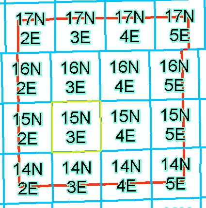
52 Government Land Office (GLO) Records Government Land Office Records County: Notes and Plats State: Notes and Plats Federal: Notes and Plats Link GLO Records to Township Polygon Layer
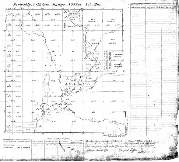
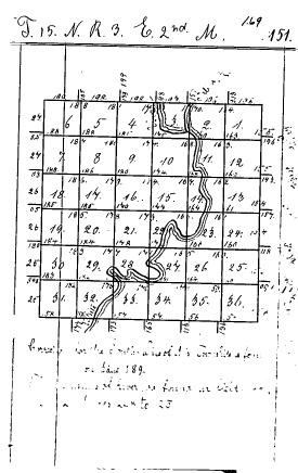
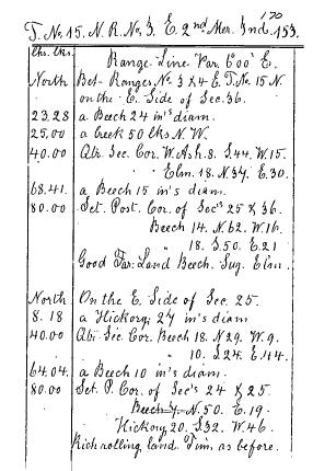
53 Government Land Office Records - County - Marion County T15N, R3E
54
 Indiana Department of Environmental Management Office of Land Quality Science Services Branch GIS and")
55 Boundaries, Cadastral and PLSS Workgroup Lorraine Wright (Chair) Indiana Department of Environmental Management Office of Land Quality Science Services Branch GIS and Engineering Section (317)
Indiana Map Resources: Cadastral, Boundaries, PLSS Workgroup Projects
 Indiana Map Resources: Cadastral, Boundaries, PLSS Workgroup Projects Lorraine Wright Indiana Department of Environmental Management Office of Land Quality Engineering and GIS Section Cadastral, Boundaries,
IC ARTICLE 19. DESCRIBING REAL PROPERTY; INDIANA COORDINATE SYSTEM. IC Chapter 1. Designation of Indiana Coordinate System; Zones
 IC 32-19 ARTICLE 19. DESCRIBING REAL PROPERTY; INDIANA COORDINATE SYSTEM IC 32-19-1 Chapter 1. Designation of Indiana Coordinate System; Zones IC 32-19-1-1 Designation of systems Sec. 1. The systems of
Indiana Land Surveys, Their Development and Uses
 Purdue University Purdue e-pubs Historical Documents of the Purdue Cooperative Extension Service Department of Agricultural Communication 9-24-2015 Indiana Land Surveys, Their Development and Uses G C.
IC ARTICLE LAND SURVEYORS
 IC 25-21.5 ARTICLE 21.5. LAND SURVEYORS IC 25-21.5-1 Chapter 1. Definitions IC 25-21.5-1-1 Application of chapter Sec. 1. The definitions in this chapter apply throughout this article. As added by P.L.23-1991,
Land Survey Research Tools
 Land Survey Research Tools Adrian Foster, GIS Technician March 3, 2011 Santa Barbara County Surveyor s Office GIS Santa Barbara County History 1542 1600's and earlier 12/4/1602 8/14/1769 4/21/1782 12/4/1786
2008 Indiana GIS Conference February 19-20, 2008
 2008 Indiana GIS Conference February 19-20, 2008 Bill Holder, GISP IGIC President IGIC Our Indiana GIS Organization Indiana Geographic Information Council, Inc. What is IGIC? IGIC is a nonprofit 501(c)3
Frequently Asked Questions about MnDOT s Railroad Map Conversion Project
 Frequently Asked Questions about MnDOT s Railroad Map Conversion Project What were the main objectives of the project? What are the results and end products? What can these railroad maps be used for? Who
The Indiana Data Sharing Initiative and the IndianaMap. Cross-Boundary Collaboration and Partnerships. State of Indiana
 The Indiana Data Sharing Initiative and the IndianaMap Cross-Boundary Collaboration and Partnerships State of Indiana Brian Arrowood, CIO James Sparks, GIO EXECUTIVE SUMMARY Under the collaboration oriented
Indiana GIS Resources
 Indiana GIS Resources National Association of Water Companies September 21, 2017 Jim Sparks Indiana Geographic Information Officer ABOUT THE INDIANA GEOGRAPHIC INFORMATION OFFICE I.C. 4-23-7.3 Indiana
INDOT Office of Traffic Safety
 Intro to GIS Spatial Analysis INDOT Office of Traffic Safety Intro to GIS Spatial Analysis INDOT Office of Traffic Safety Kevin Knoke Section 130 Program Manager Highway Engineer II Registered Professional
Curriculum Support Maps for the Study of Indiana Coal (Student Handout)
") Curriculum Support Maps for the Study of Indiana Coal (Student Handout) Introduction In this lesson you will learn how to use a geographic information system (GIS) program (IndianaMap) to investigate coal
Curriculum Support Maps for the Study of Indiana Coal (Student Handout) Introduction In this lesson you will learn how to use a geographic information system (GIS) program (IndianaMap) to investigate coal
Use of Government Land Office Surveys in Tribal GIS Land Management. Dustin Holt GIS Technician Choctaw Nation of Oklahoma
 Use of Government Land Office Surveys in Tribal GIS Land Management Dustin Holt GIS Technician Choctaw Nation of Oklahoma Ardmore Quadrangle - 1949 Different versions of the same map were printed in 1901,
ch02.pdf chap2.pdf chap02.pdf
 Introduction to Geographic Information Systems 8th Edition Karl Solutions Manual Full Download: http://testbanklive.com/download/introduction-to-geographic-information-systems-8th-edition-karl-solutions-manu
Summary of Legal Descriptions
 Perimeter Descriptions Bounds Descriptions - perimeter descriptions without a direction of travel. Metes Descriptions - perimeter descriptions with a direction of travel described by a series of measurements.
Teaching GIS for Land Surveying
 Teaching GIS for Land Surveying Zhanjing (John) Yu Evergreen Valley College, San Jose, California James Crossfield California State University at Fresno, Fresno California 7/13/2006 1 Outline of the Presentation
A DATABASE TO FACILITATE REMOVAL OF SQUAW GEOGRAPHIC PLACE NAMES IN OREGON
 A DATABASE TO FACILITATE REMOVAL OF SQUAW GEOGRAPHIC PLACE NAMES IN OREGON Caroline Rouwalk Geography 575 12-9-2008 OUTLINE Background on Squaw Geographic place names in Oregon Database design objective
1. Which agency in your state is PRIMARILY responsible for archiving geospatial data and managing archived geo records? (choose one) nmlkj.
 nmlkj.") Survey Intro Kentucky, North Carolina, and Utah are partnering with the Library of Congress as part of the National Digital Information Infrastructure and Preservation Program (NDIIPP) to examine the current
Survey Intro Kentucky, North Carolina, and Utah are partnering with the Library of Congress as part of the National Digital Information Infrastructure and Preservation Program (NDIIPP) to examine the current
Strategic Plan
 2013-2015 Strategic Plan April 23, 2014 Introduction The Indiana Geographic Information Council's (IGIC) 2013-2015 Strategic Plan establishes a path of action to meet opportunities and challenges of applying
The Dance Hall Goes in What School District?
 The Dance Hall Goes in What School District? Vern C. Svatos Jarrod S. Doucette Abstract This paper presents the results of a GIS mapping effort created for the Delaware State Department of Education using
Section 2. Indiana Geographic Information Council: Strategic Plan
 Section 2. Indiana Geographic Information Council: Strategic Plan Introduction A geographic information system (GIS) is an automated tool that allows the collection, modification, storage, analysis, and
Leveraging LiDAR for Statewide NHD Hydrography Projects. Susan Phelps, CFM, GISP
 Leveraging LiDAR for Statewide NHD Hydrography Projects Susan Phelps, CFM, GISP Mon, July 11 th, 2016 National Hydrography Dataset (NHD) Background Why Local-Res NHD? Drivers Include: Availability of accurate
Indiana GIS Local Resolution NHD Applications. Indiana State GIS Conference
 Indiana GIS Local Resolution NHD Applications Indiana State GIS Conference May 7, 2013 Agenda Topics I. Indiana s National Hydrography y Data II. Accessing NHD Data III. Demonstrations Using Local NHD
Information. Information Technology. Geographic. Services (GIS) 119 W Indiana Ave Deland, FL 32720
 119 W Indiana Ave Deland, FL 32720") Information Technology Geographic Information Services (GIS) 119 W Indiana Ave Deland, FL 32720 A GIS consists of 5 primary components: Hardware Software People Data Methods or Business Processes --- Hardware
Information Technology Geographic Information Services (GIS) 119 W Indiana Ave Deland, FL 32720 A GIS consists of 5 primary components: Hardware Software People Data Methods or Business Processes --- Hardware
10/25/2017. Overview of the issue What is meandering What is an island Research and Analysis Conclusion
 Preston Dowell Deputy County Surveyor St Louis County MN dowellp@stlouiscountymn.gov Overview of the issue What is meandering What is an island Research and Analysis Conclusion 1 The county needed to represent
INDIANAMAP VIEWING APPLICATION
 INDIANAMAP VIEWING APPLICATION (VERSION 1.0 ) Based on the 2005 Developed for the Indiana Department of Homeland Security by: IndianaMap Viewing Application Introduction The IndianaMap Viewing Application
Learning ArcGIS: Introduction to ArcCatalog 10.1
 Learning ArcGIS: Introduction to ArcCatalog 10.1 Estimated Time: 1 Hour Information systems help us to manage what we know by making it easier to organize, access, manipulate, and apply knowledge to the
Owner: Sharon Hackett. Property: 2498 SE Mullenix Road Port Orchard, WA Provided Especially For:
 Owner: Sharon Hackett Property: 2498 SE Mullenix Road Port Orchard, WA 98367 242301-4-019-2001 Provided Especially For: Danny Horovitz John L. Scott Real Estate Silverdale, WA We are pleased to provide
State GIS Officer/GIS Data
 State GIS Officer/GIS Data This Act creates the position of state Geographic Information Systems (GIS) officer. The Act: requires the state GIS officer to adopt or veto the GIS data standards and a statewide
Boundary and Annexation Survey (BAS)
") Boundary and Annexation Survey (BAS) New Mexico SDC Meeting Chris Wingate Geography Division U.S. Census Bureau 1 Agenda Boundary and Annexation Survey (BAS) BAS Overview American Community Survey (ACS)
Boundary and Annexation Survey (BAS) New Mexico SDC Meeting Chris Wingate Geography Division U.S. Census Bureau 1 Agenda Boundary and Annexation Survey (BAS) BAS Overview American Community Survey (ACS)
Chapter 1 Homework - Elements of Real Estate Law
 Chapter 1 Homework - Elements of Real Estate Law The following questions are a small example of what you might expect to see on the Real Estate Law portion of the Cadastral Mapping exam. First try answering
2013 Indiana GIS Conference. Mini-Workshop. (9:00 am 10:30 am)
") Indiana GIS LiDAR Applications 2013 Indiana GIS Conference Mini-Workshop May 7, 2013 (9:00 am 10:30 am) Topics Workshop Overview 1. Indiana Statewide Ortho-LiDAR Program Overview and Status (Phil Worrall)
Indiana GIS LiDAR Applications 2013 Indiana GIS Conference Mini-Workshop May 7, 2013 (9:00 am 10:30 am) Topics Workshop Overview 1. Indiana Statewide Ortho-LiDAR Program Overview and Status (Phil Worrall)
Copyright The McGraw-Hill Companies, Inc. Permission required for reproduction or display.
 CHAPTER 5 GIS DATA Acquisition 5.1 Existing GIS Data 5.1.1 Federal Geographic Data Committee 5.1.2 Geospatial One-Stop Box 5.1 Clearinghouse and Portal 5.1.3 U.S. Geological Survey 5.1.4 U.S. Census Bureau
Exploring the boundaries of your built and natural world. Geomatics
 Exploring the boundaries of your built and natural world Geomatics Before the Luxor brought magic to the Las Vegas strip and before the South LRT extension in Edmonton gave residents a new route to travel,
Managing Parcels in ArcGIS 10
 Managing Parcels in ArcGIS 10 ArcGIS Geodatabase Editing Workflows Editing Maps Tim Hensley Esri Solution Engineer Karen Lowrey Esri Geospatial Analyst Basemaps Public Access Value Analysis ArcGIS 10 Parcel
GEOGRAPHIC INFORMATION SYSTEMS
 GEOGRAPHIC INFORMATION SYSTEMS 4-H Round-Up Community Transitions Workshop Daniel Hanselka June 14, 2011 Goals of the Workshop Answer the question: What is GIS? Uses of GIS. Some of the Common Terminology
Calhoun County, Texas Under 5 Meter Sea Level Rise
 Kyle Kacal GEO 327G Calhoun County, Texas Under 5 Meter Sea Level Rise PROBLEM AND PURPOSE: Sea level rise is threat to all coastal areas. Although natural sea level rise happens at a very slow rate, hurricanes
Curriculum Support Maps for the Study of Indiana Coal
 Curriculum Support Maps for the Study of Indiana Coal By Walt Gray Targeted Age: High School/Middle School Activity Structure: Individual Assignment or Group Project Indiana Standards and Objectives: E.S.
Exercise 2: Working with Vector Data in ArcGIS 9.3
 Exercise 2: Working with Vector Data in ArcGIS 9.3 There are several tools in ArcGIS 9.3 used for GIS operations on vector data. In this exercise we will use: Analysis Tools in ArcToolbox Overlay Analysis
NR402 GIS Applications in Natural Resources Lesson 4 Map Projections
 NR402 GIS Applications in Natural Resources Lesson 4 Map Projections From http://www.or.blm.gov/gis/ 1 Geographic coordinates Coordinates are expressed as Latitude and Longitude in Degrees, Minutes, Seconds
LAWS OF NEW YORK, 1995 CHAPTER 605
 LAWS OF NEW YORK, 1995 CHAPTER 605 to amend chapter 545 of the laws of 1938, relating to a system of coordinates located in four zones for land boundary and survey station descriptions, in relation to
The 2020 Census Geographic Partnership Opportunities
 The 2020 Census Geographic Partnership Opportunities Web Adams Geographer, U.S. Census Bureau New York Regional Office 1 Geographic Partnership Opportunities The 2020 Census Local Update of Census Addresses
CENSUS MAPPING WITH GIS IN NAMIBIA. BY Mrs. Ottilie Mwazi Central Bureau of Statistics Tel: October 2007
 CENSUS MAPPING WITH GIS IN NAMIBIA BY Mrs. Ottilie Mwazi Central Bureau of Statistics E-mail: omwazi@npc.gov.na Tel: + 264 61 283 4060 October 2007 Content of Presentation HISTORICAL BACKGROUND OF CENSUS
The National Integrated Land System (NILS) Larry Money June 24, 2005
 Larry Money June 24, 2005") The National Integrated Land System (NILS) Larry Money June 24, 2005 Purpose/Goal Functional Components Design Data Question BLM s Responsibilities (OMB A-16) Public Land Records Public land conveyance
The National Integrated Land System (NILS) Larry Money June 24, 2005 Purpose/Goal Functional Components Design Data Question BLM s Responsibilities (OMB A-16) Public Land Records Public land conveyance
Brian D. George. GIMS Specialist Ohio Coastal Atlas Project Coordinator and Cartographer. Impacts and Outcomes of Mature Coastal Web Atlases
 Ohio Coastal Atlas Project Brian D. George GIMS Specialist Ohio Coastal Atlas Project Coordinator and Cartographer Ohio Department of Natural Resources Office of Coastal Management Sandusky, OH Impacts
John Laznik 273 Delaplane Ave Newark, DE (302)
") Office Address: John Laznik 273 Delaplane Ave Newark, DE 19711 (302) 831-0479 Center for Applied Demography and Survey Research College of Human Services, Education and Public Policy University of Delaware
Office Address: John Laznik 273 Delaplane Ave Newark, DE 19711 (302) 831-0479 Center for Applied Demography and Survey Research College of Human Services, Education and Public Policy University of Delaware
BOWIE SENIORS COMPUTER CLUB
 BOWIE SENIORS COMPUTER CLUB Meeting Minutes for May 5, 2016 Through the efforts of Program Chairman Dan Lee, we had Patrick T. Callahan, GIS Manager of the Prince George's County Office of Information
Valley-Fill Sandstones in the Kootenai Formation on the Crow Indian Reservation, South-Central Montana
 DE-FG22-96BC14996--08 Valley-Fill Sandstones in the Kootenai Formation on the Crow Indian Reservation, South-Central Montana Quarterly Report April 1 - June 30, 1998 By David A. Lopez Work Performed Under
GIS ADMINISTRATOR / WEB DEVELOPER EVANSVILLE-VANDERBURGH COUNTY AREA PLAN COMMISSION
 GIS ADMINISTRATOR / WEB DEVELOPER EVANSVILLE-VANDERBURGH COUNTY AREA PLAN COMMISSION SALARY RANGE INITIATION $43,277 SIX MONTHS $45,367 POSITION GRADE PAT VI The Evansville-Vanderburgh County Area Plan
Exercise 3: GIS data on the World Wide Web
 Exercise 3: GIS data on the World Wide Web These web sites are a few examples of sites that are serving free GIS data. Many other sites exist. Search in Google or other search engine to find GIS data for
HertfordshireCC GIS Standards (draft) Contents
 Contents") Standards for Geographic Information Systems Contents Requirements for the procurement of systems with mapping/gis functionality...2 Background...2 System Requirements...2 HCC Corporate Standard for Spatial
Standards for Geographic Information Systems Contents Requirements for the procurement of systems with mapping/gis functionality...2 Background...2 System Requirements...2 HCC Corporate Standard for Spatial
Geographical Information Systems
 Geographical Information Systems Geographical Information Systems (GIS) is a relatively new technology that is now prominent in the ecological sciences. This tool allows users to map geographic features
Megan Durden, North Carolina State Archives Butch Lazorchak, Library of Congress Mark Myers, Kentucky State Archives Best Practices Exchange, Helena,
 GIS are from Mars, Archivists are from Venus: Linking State Government Geospatial Professionals and their Cultural l Heritage Counterparts Megan Durden, North Carolina State Archives Butch Lazorchak, Library
Techniques for Science Teachers: Using GIS in Science Classrooms.
 Techniques for Science Teachers: Using GIS in Science Classrooms. After ESRI, 2008 GIS A Geographic Information System A collection of computer hardware, software, and geographic data used together for
GIS for the Beginner on a Budget
 GIS for the Beginner on a Budget Andre C. Bally, RLA, GIS Coordinator, Harris County Public Infrastructure Department Engineering Division This presentation, GIS for Beginners on a Budget. will briefly
Proclaiming Certain Lands as Reservation for the Confederated Tribes of the
 This document is scheduled to be published in the Federal Register on 11/05/2018 and available online at https://federalregister.gov/d/2018-24174, and on govinfo.gov [4337-15] DEPARTMENT OF THE INTERIOR
Mapping Historical Information Using GIS
 Mapping Historical Information Using GIS David Yun, GISP Troy Lawson ABSTRACT The City of San Luis Obispo, California, is rich with history. It is one of California s oldest communities that began with
Annual TTFO Meeting April 10, 2018 Michael J. Wittman, P.S. Chief Surveyor / GIS Coordinator
 Annual TTFO Meeting April 10, 2018 Michael J. Wittman, P.S. Chief Surveyor / GIS Coordinator Text Book Definition: Layman Terms: An organized collection of hardware, software and geographic data designed
Appropriation Directions for 2007
 INSPIRE in Sweden An Important Part of the National Geodata Strategy Monica Lagerqvist Nilsson Appropriation Directions for 2007 A commission to investigate the necessity to adjust the Swedish legislation
Current Status of the Standardization of Geographical Names in Cambodia
 1 Current Status of the Standardization of Geographical Names in Cambodia His Excellency Ith Sotha, Under Secretary of States, MLMUPC Mr Chharom Chin, Deputy Director, Geography Department, MLMUPC Mr Narith
Exercise 2: Working with Vector Data in ArcGIS 9.3
 Exercise 2: Working with Vector Data in ArcGIS 9.3 There are several tools in ArcGIS 9.3 used for GIS operations on vector data. In this exercise we will use: Analysis Tools in ArcToolbox Overlay Analysis
Introduction to Coastal GIS
 Introduction to Coastal GIS Event was held on Tues, 1/8/13 - Thurs, 1/10/13 Time: 9:00 am to 5:00 pm Location: Roger Williams University, Bristol, RI Audience: The intended audiences for this course are
Utilizing Data from American FactFinder with TIGER/Line Shapefiles in ArcGIS
 Utilizing Data from American FactFinder with TIGER/Line Shapefiles in ArcGIS Web Adams, GISP Data Dissemination Specialist U.S. Census Bureau New York Regional Office 1 What We Do Decennial Census Every
Paths Toward CAD and GIS Interoperability
 Paths Toward CAD and GIS Interoperability Bo Guo, PhD, PE Gistic Research, Inc Outline CAD and GIS Differences Interoperability Paths UDOT ROW Research Project CAD and GIS: The Difference (I) History Users
H. R heading to fund the award and oversight by the Administrator of grants made under this heading. FEDERAL HIGHWAY ADMINISTRATION
 H. R. 1 92 heading to fund the award and oversight by the Administrator of grants made under this heading. FEDERAL HIGHWAY ADMINISTRATION HIGHWAY INFRASTRUCTURE INVESTMENT For an additional amount for
Chapter 3 Geographic Location Systems
 Chapter 3 Geographic Location Systems In this chapter you will learn about: Latitude and longitude Universal Transverse Mercator (UTM) U.S. Public Land Survey Other geographic location systems Geographic
Gis Unit TropMed Mahidol U.
 Gis Unit TropMed Mahidol U. Database Information System Database Concepts 1. Non-Spatial Database table, document.. 2. Spatial Database locational databases (geographic) + attribute databases Gis Unit
This week s topics. Week 6. FE 257. GIS and Forest Engineering Applications. Week 6
 FE 257. GIS and Forest Engineering Applications Week 6 Week 6 Last week Chapter 8 Combining and splitting landscape features and merging GIS databases Chapter 11 Overlay processes Questions? Next week
The State of California s GeoSteam Database & Well Finder On-line Mapping System
 PROCEEDINGS, Thirty-Eighth Workshop on Geothermal Reservoir Engineering Stanford University, Stanford, California, February 24-26, 2014 SGP-TR-202 The State of California s GeoSteam Database & Well Finder
2007 / 2008 GeoNOVA Secretariat Annual Report
 2007 / 2008 GeoNOVA Secretariat Annual Report Prepared for: Assistant Deputy Minister and Deputy Minister of Service Nova Scotia and Municipal Relations BACKGROUND This report reflects GeoNOVA s ongoing
Applied Cartography and Introduction to GIS GEOG 2017 EL. Lecture-1 Chapters 1 and 2
 Applied Cartography and Introduction to GIS GEOG 2017 EL Lecture-1 Chapters 1 and 2 What is GIS? A Geographic Information System (GIS) is a computer system for capturing, storing, querying, analyzing and
Welcome to Lesson 4. It is important for a GIS analyst to have a thorough understanding of map projections and coordinate systems.
 Welcome to Lesson 4. It is important for a GIS analyst to have a thorough understanding of map projections and coordinate systems. A GIS without coordinates would simply be a database like Microsoft Excel
Creation of an Internet Based Indiana Water Quality Atlas (IWQA)
") Department of Environmental Management Creation of an Internet Based Water Quality Atlas (IWQA) May 4, 2005 IUPUI 1200 Waterway Blvd., Suite 100 polis, 46202-5140 Water Quality Atlas John Buechler, Neil
Department of Environmental Management Creation of an Internet Based Water Quality Atlas (IWQA) May 4, 2005 IUPUI 1200 Waterway Blvd., Suite 100 polis, 46202-5140 Water Quality Atlas John Buechler, Neil
Utilizing GIS Technology for Rockland County. Rockland County Planning Department Douglas Schuetz & Scott Lounsbury
 Utilizing GIS Technology for Rockland County Rockland County Planning Department Douglas Schuetz & Scott Lounsbury Presentation Agenda Introduction What is GIS What can GIS do GIS Efforts for BOE Resources
IMPERIAL COUNTY PLANNING AND DEVELOPMENT
 IMPERIAL COUNTY PLANNING AND DEVELOPMENT GEODATABASE USER MANUAL FOR COUNTY BUSINESS DEVELOPMENT GIS June 2010 Prepared for: Prepared by: County of Imperial Planning and Development 801 Main Street El
Preparing Spatial Data
 13 CHAPTER 2 Preparing Spatial Data Assessing Your Spatial Data Needs 13 Assessing Your Attribute Data 13 Determining Your Spatial Data Requirements 14 Locating a Source of Spatial Data 14 Performing Common
ArcMap - EXPLORING THE DATABASE Part I. SPATIAL DATA FORMATS Part II
 Week 5 ArcMap - EXPLORING THE DATABASE Part I SPATIAL DATA FORMATS Part II topics of the week Exploring the Database More on the Table of Contents Exploration tools Identify, Find, Measure, Map tips, Hyperlink,
 Boone County GIS has the right to inquire about and investigate the use of any requested products and deny access to anyone based on concerns relating to privacy, security, public health, public safety,
The Next Generation GIS/LIS A Surveys Information System Integrated within a GIS
 The Next Generation GIS/LIS A Surveys Information System Integrated within a GIS Michael F. WEIR, USA Key words: Linking, Snapping, GIS, Measurements, Measurement Data, GIS Features, Spatial Quality. SUMMARY
Comptroller GIS and Property Data. Ken Morrell Assessment Systems Manager Division of Property Assessments February 22, 2007
 Comptroller GIS and Property Data Ken Morrell Assessment Systems Manager Division of Property Assessments February 22, 2007 Comptroller Divisions Using and Supporting GIS Office of Local Government Implement
Enhancing Parcel Data In Colleton County. February 10, 2009
 Enhancing Parcel Data In Colleton County GIS & CAMA Conference February 10, 2009 Introductions Bruce T. Harper Technology Director Colleton County, SC Bill Wetzel National GIS Account Manager The Sidwell
SECTION 4 PARCEL IDENTIFIERS 4.1 LONGITUDE AND LATITUDE
 SECTION 4 PARCEL IDENTIFIERS 4.1 LONGITUDE AND LATITUDE Most maps must be drawn in such a way that points and areas can be located accurately on the earth's surface and described objectively. A uniform
Utah UIC Geospatial Integration EIEN Project
 Utah UIC Geospatial Integration EIEN Project ESRI UC, June 2007 Bert Granberg Utah Automated Geographic Reference Center Utah Automated Geographic Reference Center (AGRC) AGRC Responsibilities Facilitate
Fusion of Geodesy and GIS at NOAA s National Geodetic Survey
 Fusion of Geodesy and GIS at NOAA s National Geodetic Survey Esri Survey Summit July 6-9, 2013 San Diego, CA Michael Dennis, RLS, PE michael.dennis@noaa.gov The Plan Background NGS Data Explorer New Datasheet
Outline Brief Overview MapPlace Website Data Delivery & Map Themes Digital Geology
 BRITISH COLUMBIA GEOLOGICAL SURVEY Kirk Hancock Pat Desjardins Nick Massey BRITISH COLUMBIA Ministry of Energy and Mines Ward Kilby acknowledged developer of MapPlace Outline Brief Overview MapPlace Website
COGCC Interim Policy for APDs. Tutorial December 2008
 COGCC Interim Policy for APDs Tutorial December 2008 Purpose of Interim Policy and Interim Policy Period The Interim Policy was requested by the Commission to gather data on the number of permits filed
Basis of Bearings INTRODUCTION: WARNING: Basis of Bearings NYSAPLS Conf January Scott Reeser, P.L.S. NYSAPLS 2018 Conference
 Basis of Bearings Scott Reeser, P.L.S. NYSAPLS 2018 Conference INTRODUCTION: Over 25 years experience in the surveying profession Graduate of Penn State survey program Licensed in Pennsylvania, New York,
SUMMARY OF RESEARCH; EASY CHAIR CRATER ROAD # USGS Topo Proof Map FLPMA The use of and jurisdiction of EASY CHAIR CRATER ROAD
 SUMMARY OF RESEARCH; EASY CHAIR CRATER ROAD #955540 1967 - USGS Topo Proof Map 1976 - FLPMA The use of and jurisdiction of EASY CHAIR CRATER ROAD #955540 pre-dates the Bureau of Land Management. Historical
DIRECTORY OF COAL MINES IN ILLINOIS
 DIRECTORY OF COAL MINES IN ILLINOIS Marion County This directory accompanies the Illinois Coal Mines map or maps for this County. August 2018 Prairie Research Institute Illinois State Geological Survey
Louisiana Transportation Engineering Conference. Monday, February 12, 2007
 Louisiana Transportation Engineering Conference Monday, February 12, 2007 Agenda Project Background Goal of EIS Why Use GIS? What is GIS? How used on this Project Other site selection tools I-69 Corridor
Construction Project Data Management
 Construction Project Data Management Establishing Foundations for an Asset Database Scot Twining Project Activities Supported by GIS Cadastral Mapping Proposed Pipeline Route Selection Right Of Way Acquisition
Internet Mapping Framework 1 (IMF) to Common Web Mapping (CWM) Legend Comparison
 to Common Web Mapping (CWM) Legend Comparison") Internet Mapping Framework 1 (IMF) to Common Web Mapping () Legend Comparison IMF Legend Legend Folders Titles (MTO) - Mineral, Placer, Coal Map Viewers.. 3 Coal Grid - Coal Map Viewer. 4 Tenure History
Internet Mapping Framework 1 (IMF) to Common Web Mapping () Legend Comparison IMF Legend Legend Folders Titles (MTO) - Mineral, Placer, Coal Map Viewers.. 3 Coal Grid - Coal Map Viewer. 4 Tenure History
Task 1: Start ArcMap and add the county boundary data from your downloaded dataset to the data frame.
 Exercise 6 Coordinate Systems and Map Projections The following steps describe the general process that you will follow to complete the exercise. Specific steps will be provided later in the step-by-step
Using a GIS to Calculate Area of Occupancy. Part 1: Creating a Shapefile Grid
 Using a GIS to Calculate Area of Occupancy Part 1: Creating a Shapefile Grid By Ryan Elliott California Natural Diversity Database, A NatureServe network program December 2008 This document describes the
Chapter 5 LiDAR Survey and Analysis in
 Chapter 5 LiDAR Survey and Analysis in 2010-2011 Christopher Fennell A surveyor s plat and town plan filed in 1836 set out an intended grid of blocks, lots, alleys, and streets for New Philadelphia. Geophysical,
Lecture 9: Reference Maps & Aerial Photography
 Lecture 9: Reference Maps & Aerial Photography I. Overview of Reference and Topographic Maps There are two basic types of maps? Reference Maps - General purpose maps & Thematic Maps - maps made for a specific
25. A Strategy for Integrating GIS
 25. A Strategy for Integrating GIS Richard P. Greene Introduction The teaching modules enabled middle and high school teachers in the Rockford public schools to explore the local community with geographic
Checking private survey maps for compliance with Oregon statutes and file them in the Surveyor s Office as public records.
 Department: Surveyor FY 2019 Proposed Budget Department Mission: To provide the citizens an organized facility to research the surveying records and to provide for the safe keeping of the public records
Geography 281 Map Making with GIS Project Eight: Comparing Map Projections
 Geography 281 Map Making with GIS Project Eight: Comparing Map Projections In this activity, you will do a series of projection comparisons using maps at different scales and geographic extents. In this
GIS and Community Health. GIS and Community Health. Institutional Context and Interests in GIS Development. GIS and Community Health
 GIS and Community Health GIS and Community Health Some critiques of GIS emphasize the potentially harmful social consequences of the diffusion of GIS technology, including reinforcing the power of state
b. What is the length, width (ft), and direction of flow of Seafield Lake?
, and direction of flow of Seafield Lake?") FOR 274 Assignment 3 [50 points] Name: Section: This assignment should be completed and handed in to the assignment box in the Forest Resources office by noon on Monday 17th of September. Partial credit
FOR 274 Assignment 3 [50 points] Name: Section: This assignment should be completed and handed in to the assignment box in the Forest Resources office by noon on Monday 17th of September. Partial credit