The 2020 Census Geographic Partnership Opportunities
|
|
|
- Catherine Marsh
- 5 years ago
- Views:
Transcription

1 The 2020 Census Geographic Partnership Opportunities Web Adams Geographer, U.S. Census Bureau New York Regional Office 1


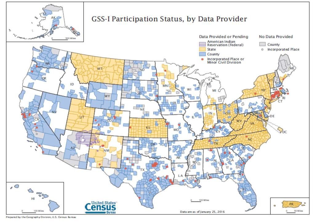
2 Geographic Partnership Opportunities The 2020 Census Local Update of Census Addresses Participant Statistical Areas Program Geographic Support System Boundary and Annexation Survey BQARP Boundary Quality Assessment & Reconciliation Project Tools: GUPS, SWIM, Community TIGER 2
3 2020 Local Update of Census Addresses Program A once-a-decade-opportunity for designated representatives to review the addresses that will be used to conduct the Decennial Census Single, Simplified Option: Title 13, Full Address List Review Reduce the number of deleted LUCA records in field verification activities Reduce the burden and the complexity of LUCA Continuous feedback throughout the decade through the Geographic Support System program No Boundary & Annexation Survey as LUCA component for
4 2020 LUCA Program New for 2020 Include census structure coordinates in the census address list and allow partners to return their structure coordinates as part of their submission Provide ungeocoded (no geographic coordinates) U.S. Postal Service Delivery Sequence File addresses to State and County partners Provide address list in more standard formats (.xlsx &.csv) We ll provide address counts in early 2017 and a public geocoding tool so you can geocode your address list to assess whether you d like to participate 4
 Digital (Commercial GIS/Spreadsheet/Database software) Paper Address List and Maps (Available only to")

5 2020 LUCA Program Participation Options & Schedule Participation Options: GUPS (Geographic Update Partnership Software) Digital (Commercial GIS/Spreadsheet/Database software) Paper Address List and Maps (Available only to governments with < 6000 addresses) Background imagery on paper maps? Tentative Schedule: Program Invitation: July 2017 Materials Available for Review: February 2018 LUCA Feedback Provided: August 2019 LUCA Appeals: October
6 Geographic Support System GSS: Opportunity to submit addresses and spatial data to Census Bureau on a continual basis Goal: Add new addresses to the Master Address File (MAF), new streets to TIGER, and resolve address and spatial inconsistencies Must meet minimum address guidelines After acquiring partner data, Census performs content verification to determine usability Crosswalk, standardize, match, and geocode partner addresses and structure points using Master Address File Match street centerline data to ID differences, calculate spatial accuracy (CE95 method) of partner data using GPS control points new.york.geography@ census.gov 6
7 7
8 2020 Participant Statistical Areas Program Opportunity for designated representatives to review and update statistical geographies for 2020 Census data tabulation Possible renaming of program Enables coordinating agencies to review, identify, propose changes and delineate new census tracts, block groups, census designated places (CDPs), and census county divisions (CCDs). TSAP folded into PSAP: ONE program on one schedule 2 Phases: Delineation (120-day review) Verification 8
9 2020 PSAP Plan New for 2020 Census Bureau intends to create a 2020 statistical areas plan for both the standard and tribal statistical geographies, which our partners can review and update Lessens burden on our partners Ensures that ALL statistical geographies are reviewed/updated consistently More extensive review than just criteria thresholds Partners can update the 2020 plan OR they have option to update from 2010 statistical geography base GOAL: Clean, Consistent Statistical Geography Nationwide 9
10 2020 PSAP Participation Options & Schedule Standard Statistical Geographies: GUPS Geographic Update Partnership Software Tribal Statistical Geographies: GUPS or Paper Maps Tentative Schedule: Program Invitation: Spring 2017 Materials Available: Winter 2018 PSAP Verification: Fall/Winter
11 Annual Boundary & Annexation Survey Legal Boundaries in Effect on January 1 Annual Survey to collect legal Boundaries in effect on January 1 of the BAS year Boundaries are used to tabulate data for: Decennial Census (year ending in 0) Economic Censuses (years ending in 2, 7) Population Estimates Program (annually) American Community Survey (annually) Survey sent starting in December, materials still available (BAS 2017 survey sent in December 2016) 11
 Digital (Commercial GIS) Paper")
12 Boundary & Annexation Survey Deadlines: March 1 of Survey Year: updates reflected in American Community Survey (ACS) and Population Estimates Program (PEP) May 31 of Survey Year: updates reflected in the following year s BAS Participation Options: Deadlines & Participation Options GUPS (Geographic Update Partnership Software ) Digital (Commercial GIS) Paper Maps 12
13 Boundary & Annexation Survey Coordination with Redistricting As part of 2020 Redistricting Data Program, State RDP Liaisons may submit boundary updates in Phase 1 (BBSP) & Phase 2 (VTD) new for 2020 Census BAS staff coordinates any RDP-submitted updates with local BAS official for the jurisdiction More info on 2020 Redistricting Data Program: 13
14 BAS Consolidation by the State or a County Government State-Level BAS consolidation: Appropriate where state law dictates that all governments within the state must provide legal changes to a state office County-Level BAS Consolidation: County responds to BAS for governments within the county (entities must agree) Consolidation can eliminate duplication of effort, save money, ensure boundary changes are being reported, contributes to the National Spatial Data Infrastructure (Census Bureau is boundary steward under OMB Circular A-16) Good Opportunity to Update Boundaries before LUCA! 14
15 Boundary Validation Program January 2020 Highest Elected Officials and Tribal Chairs provided maps of jurisdictional boundaries for review and update Boundaries as of January 1, 2020 that will be used for 2020 Census data tabulation 15
 to adjust Census boundaries Align to parcel and PLSS boundaries, where applicable Coordinate efforts with State partners Lock boundaries in place to prevent changes")
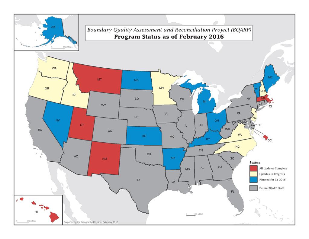
16 Boundary Quality Assessment and Reconciliation Project BQARP Goal: Improve legal and administrative spatial boundary quality in MAF/TIGER System Compare locally sourced data (we acquire whole data sets, not transaction polygons) to adjust Census boundaries Align to parcel and PLSS boundaries, where applicable Coordinate efforts with State partners Lock boundaries in place to prevent changes without legal documentation Independent of BAS 16
17 17
18 Census Bureau Geographic Partnership Tools GUPS: Geographic Update Partnership Software Self-contained GIS software package that allows partners with or without GIS software to digitally participate in Census geographic programs, including address updates Replaces the MAF/TIGER Partnership Software (MTPS) Includes built-in tools and verification checks to ensure your data output adheres to program criteria and is formatted correctly so it can be accepted and processed by Census Supports all Geographic Partnership Programs: RDP Redistricting Data Program LUCA Local Update of Census Addresses PSAP Participant Statistical Areas Program SDRP School District Review Program BAS Boundary & Annexation Survey PUMA Public Use Microdata Areas TAZ/TAD Traffic Analysis Zones/Traffic Analysis Districts CQR Count Question Resolution 18

19 Census Bureau Geographic Partnership Tools GUPS: Geographic Update Partnership Software 19

20 SWIM: Secure Web Incoming Module Official web portal for uploading partnership materials to the Census Bureau User 20
21 Community TIGER: Address & Spatial Data Sharing Partnership with ESRI No-cost access to ArcGIS software Cloud environment (Amazon WorkSpaces) Standardizes local data Validates data prior to submittal Manages data submittals Adheres to Census Bureau minimum data standards Supports National Address Database development Send requesting Community TIGER registration to to get started 21
22 The 2020 Census Key Geographic Partnership Activities BAS 2016 deadline to be included in ACS, PEP - March 1 BAS 2016 deadline for updates to be included in next year s BAS - April 31: BAS 2017 annual invitation to update legal boundaries - December LUCA Advance Notice sent to Highest Elected Officials January BAS 2017 deadline to be included in ACS, PEP - March 1 BAS 2017 deadline for updates to be included in next year s BAS - April 31: LUCA Invitation to review Master Address File July 2017 BAS 2018 annual invitation to update legal boundaries - December LUCA materials available for review- February (120 days) PSAP materials available for review -December 120 days BAS schedule repeated as above LUCA Feedback provided to participants - August LUCA Appeals Process - October PSAP Verification materials available for review- Fall/Winter BAS schedule repeated as above Boundary Validation Program maps sent to HEO/Tribal Chair -January Census Day April 1, 2020 Apportionment Counts to the President- by December 31, 2020 BAS schedule repeated as above Redistricting Counts to the States - by March 31, 2021 BAS schedule repeated as above 22

23 Visit Our Census Geographic Partnerships Page 23

")
24 Questions Thank you Web Adams, GISP Geographer, U.S. Census Bureau New York Regional Office 32 Old Slip 9 th Floor New York, NY, (212) william.w.adams@census.gov 24
Boundary and Annexation Survey (BAS)
") Boundary and Annexation Survey (BAS) New Mexico SDC Meeting Chris Wingate Geography Division U.S. Census Bureau 1 Agenda Boundary and Annexation Survey (BAS) BAS Overview American Community Survey (ACS)
Boundary and Annexation Survey (BAS) New Mexico SDC Meeting Chris Wingate Geography Division U.S. Census Bureau 1 Agenda Boundary and Annexation Survey (BAS) BAS Overview American Community Survey (ACS)
2010 Census Data Release and Current Geographic Programs. Michaellyn Garcia Geographer Seattle Regional Census Center
 2010 Census Data Release and Current Geographic Programs Michaellyn Garcia Geographer Seattle Regional Census Center 2010 Center of Population Located approximately 2.7 miles northeast of Plato, Missouri
State GIS Update. Master Address Repository (MAR) IMAGIN 2016 Everett Root May 16, 2016
 IMAGIN 2016 Everett Root May 16, 2016") State GIS Update Master Address Repository (MAR) IMAGIN 2016 Everett Root roote@michigan.gov May 16, 2016 Master Address Repository Mark Holmes GeoSpatial Services Manager (MAR) Josh Ross Framework Manager
State GIS Update Master Address Repository (MAR) IMAGIN 2016 Everett Root roote@michigan.gov May 16, 2016 Master Address Repository Mark Holmes GeoSpatial Services Manager (MAR) Josh Ross Framework Manager
Utilizing Data from American FactFinder with TIGER/Line Shapefiles in ArcGIS
 Utilizing Data from American FactFinder with TIGER/Line Shapefiles in ArcGIS Web Adams, GISP Data Dissemination Specialist U.S. Census Bureau New York Regional Office 1 What We Do Decennial Census Every
Office of Technology Partnerships GIS Collaboration
 Office of Technology Partnerships GIS Collaboration State GIS Update April 21, 2017 Mark Holmes, GISP Outline MGF Upgrade Project Census Programs Imagery Update LiDAR Update Open Discussion 2 MGF Background
Utilizing GIS Technology for Rockland County. Rockland County Planning Department Douglas Schuetz & Scott Lounsbury
 Utilizing GIS Technology for Rockland County Rockland County Planning Department Douglas Schuetz & Scott Lounsbury Presentation Agenda Introduction What is GIS What can GIS do GIS Efforts for BOE Resources
PLANNING FOR THE FUTURE: THE GEOGRAPHIC SUPPORT SYSTEM INITIATIVE FOR THE U.S. CENSUS BUREAU
 PLANNING FOR THE FUTURE: THE GEOGRAPHIC SUPPORT SYSTEM INITIATIVE FOR THE U.S. CENSUS BUREAU Tim Trainor Geography Division, U.S. Census Bureau, Washington, DC. 20233 timothy.f.trainor@census.gov KEY WORDS:
The 2010 Census Successful Because of GIS
 The 2010 Census Successful Because of GIS Timothy F. Trainor Chief, Geography Division, U.S. Census Bureau Vice President, International Cartographic Association Establishing the Framework of the Operation
Geographic Products and Data. Improvements in Spatial Accuracy and Accessing Data
 Geographic Products and Data Improvements in Spatial Accuracy and Accessing Data How it Began TIGER was internally developed to support the 1990 Decennial Census operations Used data sources such as USGS
2020 Census Participant Statistical Areas Program (PSAP) Standard Statistical Geography Webinar
 Standard Statistical Geography Webinar") 2020 Census Participant Statistical Areas Program (PSAP) Standard Statistical Geography Webinar Agenda PSAP Overview. Schedule. Materials. Standard Statistical Geography Overview. Geographic Update Partnership
2020 Census Participant Statistical Areas Program (PSAP) Standard Statistical Geography Webinar Agenda PSAP Overview. Schedule. Materials. Standard Statistical Geography Overview. Geographic Update Partnership
GIS ADMINISTRATOR / WEB DEVELOPER EVANSVILLE-VANDERBURGH COUNTY AREA PLAN COMMISSION
 GIS ADMINISTRATOR / WEB DEVELOPER EVANSVILLE-VANDERBURGH COUNTY AREA PLAN COMMISSION SALARY RANGE INITIATION $43,277 SIX MONTHS $45,367 POSITION GRADE PAT VI The Evansville-Vanderburgh County Area Plan
Census Geography, Geographic Standards, and Geographic Information
 Census Geography, Geographic Standards, and Geographic Information Michael Ratcliffe Geography Division US Census Bureau New Mexico State Data Center Data Users Conference November 19, 2015 Today s Presentation
Internal Audit Report
 Internal Audit Report Right of Way Mapping TxDOT Internal Audit Division Objective To determine the efficiency and effectiveness of district mapping procedures. Opinion Based on the audit scope areas reviewed,
Census and USGS: Bringing Improved TIGER to The National Map. Jennie Karalewich-Census Andrea Johnson- Census Dick Vraga- USGS
 Census and USGS: Bringing Improved TIGER to The National Map Jennie Karalewich-Census Andrea Johnson- Census Dick Vraga- USGS USGS and the Census Bureau Since 1880 there has been a close working relationship
MAPPS 2012 Geospatial Products and Services Excellence Awards Awards Entry Form
 MAPPS 2012 Geospatial Products and Services Excellence Awards 2012 Awards Entry Form Please include a copy of this document with the project/product submission Entry Information Submission Number: 1741558
John Laznik 273 Delaplane Ave Newark, DE (302)
") Office Address: John Laznik 273 Delaplane Ave Newark, DE 19711 (302) 831-0479 Center for Applied Demography and Survey Research College of Human Services, Education and Public Policy University of Delaware
Office Address: John Laznik 273 Delaplane Ave Newark, DE 19711 (302) 831-0479 Center for Applied Demography and Survey Research College of Human Services, Education and Public Policy University of Delaware
To: Ross Martin, Lisa Stapleton From: Brad Lind Subject: Joint Funding Agreement with USGS for 2012 Imagery Date: March 14, 2012.
 To: Ross Martin, Lisa Stapleton From: Brad Lind Subject: Joint Funding Agreement with USGS for 2012 Imagery Date: March 14, 2012 Attached are two copies of the Joint Funding Agreement (JFA) between SanGIS
E Geographic Information System. Created By: Freda Rocker Pearl River County Mapping
 E-9-1-1 Geographic Information System Created By: Freda Rocker Pearl River County Mapping frocker@pearlrivercounty.net Overview of Pearl River County E-9-1-1 Communications District GIS In 1998 the Pearl
Getting Started with Community Maps
 Esri International User Conference San Diego, California Technical Workshops July 24, 2012 Getting Started with Community Maps Shane Matthews and Tamara Yoder Topics for this Session ArcGIS is a complete
SCAUG Community Maps Building a Living Atlas of the World
 SCAUG Community Maps Building a Living Atlas of the World Mark Stewart Topics: SCAUG ArcGIS Online Overview Community Maps Overview Community Maps Workflow Update Process Utilizing Your Contribution Community
New York City Public Use Microdata Areas (PUMAs) for 2010 Census
 for 2010 Census") New York City Public Use Microdata Areas (PUMAs) for 2010 Census ESRI Shapefile Tags PUMA, Public Use Microdata Area, Census, New York, Manhattan, Queens, Brooklyn, Richmond, Bronx, Kings, Staten Island,
New York City Public Use Microdata Areas (PUMAs) for 2010 Census ESRI Shapefile Tags PUMA, Public Use Microdata Area, Census, New York, Manhattan, Queens, Brooklyn, Richmond, Bronx, Kings, Staten Island,
2013 NASCIO Award Submission Category: Cross-Boundary Collaboration and Partnerships. Project Title: Public Safety and Enterprise GIS in Tennessee
 2013 NASCIO Award Submission Category: Cross-Boundary Collaboration and Partnerships Project Title: Public Safety and Enterprise GIS in Tennessee State of Tennessee, Board of Parole State of Tennessee,
US Census Bureau Geographic Entities and Concepts. Geography Division
 US Census Bureau Geographic Entities and Concepts Geography Division Geographic Concepts Addresses vs. Geographic features and entities Legal/Administrative vs. Statistical Nesting relationships (or the
GEOGRAPHIC INFORMATION SYSTEMS Session 8
 GEOGRAPHIC INFORMATION SYSTEMS Session 8 Introduction Geography underpins all activities associated with a census Census geography is essential to plan and manage fieldwork as well as to report results
The History Behind Census Geography
 The History Behind Census Geography Michael Ratcliffe Geography Division US Census Bureau Kentucky State Data Center Affiliate Meeting August 5, 2016 Today s Presentation A brief look at the history behind
OC Enterprise GIS. Kevin Hills, PLS Cameron Smith, GISP. OC Survey
 OC Enterprise GIS Kevin Hills, PLS Cameron Smith, GISP OC Survey Discussion Points Background & Organizational Structure of OCPW Past practices prior to Enterprise Wide GIS License (ELA) Participating
Targeted LiDAR use in Support of In-Office Address Canvassing (IOAC) March 13, 2017 MAPPS, Silver Spring MD
 March 13, 2017 MAPPS, Silver Spring MD") Targeted LiDAR use in Support of In-Office Address Canvassing (IOAC) March 13, 2017 MAPPS, Silver Spring MD Imagery, LiDAR, and Blocks In 2011, the GEO commissioned independent subject matter experts (Jensen,
Targeted LiDAR use in Support of In-Office Address Canvassing (IOAC) March 13, 2017 MAPPS, Silver Spring MD Imagery, LiDAR, and Blocks In 2011, the GEO commissioned independent subject matter experts (Jensen,
The History Behind Census Geography
 The History Behind Census Geography Michael Ratcliffe Geography Division US Census Bureau Tennessee State Data Center August 8, 2017 Today s Presentation A brief look at the history behind some of the
Key Steps for Assessing Mission Critical Data for An ebook by Geo-Comm, Inc.
 Key Steps for Assessing Mission Critical Data for 9-1-1 An ebook by Geo-Comm, Inc. If you re reading this, you probably understand transitioning to Next Generation 9-1-1 (NG9-1-1) means your Geographic
Office of Geographic Information Systems
 Office of Geographic Information Systems Print this Page Spring 2008 - Desktop GIS: Collecting Features from Orthos By Joe Sapletal, GISP Keeping up with the growth of our area over the last ten years
UTILIZING GIS IN NEXT GENERATION Tennessee Information for Public Safety. Presented by State of TN, OIR-GIS Services
 UTILIZING GIS IN NEXT GENERATION 9-1-1 Tennessee Information for Public Safety Presented by State of TN, OIR-GIS Services Next Generation 9-1-1 WHAT IT IS AND HOW IT WORKS Next Generation 9-1-1 IP (Internet
GIS-T 2010 Building a Successful Geospatial Data Sharing Framework: A Ohio DOT Success Story
 GIS-T 2010 Building a Successful Geospatial Data Sharing Framework: A Ohio DOT Success Story ODOT District 2 GIS John Puente District 1 GIS Coordinator\ Planning Administrator 2 Interoperability 3 District
WELCOME & INTRODUCTIONS
 GIS Monroe Geographic Information System January 31, 2018 WELCOME & INTRODUCTIONS Chip Thomas, Ritter GIS Sarah Schrader, Acct. Mgr., ESRI Chris Beyett, Solutions Engineer, ESRI Colleen Hinzmann, IT Director,
IMPERIAL COUNTY PLANNING AND DEVELOPMENT
 IMPERIAL COUNTY PLANNING AND DEVELOPMENT GEODATABASE USER MANUAL FOR COUNTY BUSINESS DEVELOPMENT GIS June 2010 Prepared for: Prepared by: County of Imperial Planning and Development 801 Main Street El
BROOKINGS May
 Appendix 1. Technical Methodology This study combines detailed data on transit systems, demographics, and employment to determine the accessibility of jobs via transit within and across the country s 100
GIS Resources for Local Governments
 ISSUE PAPER SERIES GIS Resources for Local Governments February 2018 NEW YORK STATE TUG HILL COMMISSION DULLES STATE OFFICE BUILDING 317 WASHINGTON STREET WATERTOWN, NY 13601 (315) 785-2380 WWW.TUGHILL.ORG
LAND INFORMATION SYSTEM A TOOL TO KEEP THE REGISTRY OF PLANNING PERMISSION. CASE STUDY OF THE SZCZUTOWO COMMUNE
 INFRASTRUKTURA I EKOLOGIA TERENÓW WIEJSKICH INFRASTRUCTURE AND ECOLOGY OF RURAL AREAS Nr 2/IV/2013, POLSKA AKADEMIA NAUK, Oddział w Krakowie, s. 15 27 Komisja Technicznej Infrastruktury Wsi LAND INFORMATION
VT STATEWIDE PROPERTY PARCEL MAPPING PROJECT & PROGRAM
 VT STATEWIDE PROPERTY PARCEL MAPPING PROJECT & PROGRAM BUILDING A FOUNDATIONAL MAPPING DATA LAYER Leslie Pelch, VCGI April 2017 WHAT ARE THE STATEWIDE PROPERTY PARCEL MAPPING PROJECT & PROGRAM? A project
Regional GIS Presentation for Small and Large Jurisdictions. Michelle E. Fults GIS Manager January 8, 2009
 Regional GIS Presentation for Small and Large Jurisdictions Michelle E. Fults GIS Manager January 8, 2009 Presentation Contributions from Juston Manville Henrico County Kevin Nelson Hanover County Mark
CHAPTER 22 GEOGRAPHIC INFORMATION SYSTEMS
 CHAPTER 22 GEOGRAPHIC INFORMATION SYSTEMS PURPOSE: This chapter establishes the administration and use of to improve the quality and accessibility of Department s spatial information and support graphical
GIS Monroe Geographic Information System March 14, 2018
 GIS Monroe Geographic Information System March 14, 2018 Goals Maintain Enterprise/County-wide geo-database Increase spatial accuracy of data Build and acquire more data layers Increase use of GIS; as another
Reference: 4880(DOP.ADA)1136 Subject: Survey on the integration of geographic information systems into postal address development
1136 Subject: Survey on the integration of geographic information systems into postal address development") International Bureau Weltpoststrasse 4 P.O. Box 312 3000 BERNE 15 SWITZERLAND To: Union member countries Regulators Designated operators T +41 31 350 31 11 F +41 31 350 31 10 www.upu.int For information
International Bureau Weltpoststrasse 4 P.O. Box 312 3000 BERNE 15 SWITZERLAND To: Union member countries Regulators Designated operators T +41 31 350 31 11 F +41 31 350 31 10 www.upu.int For information
Census Transportation Planning Products (CTPP)
") Census Transportation Planning Products (CTPP) Penelope Weinberger CTPP Program Manager - AASHTO September 15, 2010 1 What is the CTPP Program Today? The CTPP is an umbrella program of data products, custom
Census Transportation Planning Products (CTPP) Penelope Weinberger CTPP Program Manager - AASHTO September 15, 2010 1 What is the CTPP Program Today? The CTPP is an umbrella program of data products, custom
FHWA Planning Data Resources: Census Data Planning Products (CTPP) HEPGIS Interactive Mapping Portal
 HEPGIS Interactive Mapping Portal") FHWA Planning Data Resources: Census Data Planning Products (CTPP) HEPGIS Interactive Mapping Portal Jeremy Raw, P.E. FHWA, Office of Planning, Systems Planning and Analysis August 2017 Outline Census
FHWA Planning Data Resources: Census Data Planning Products (CTPP) HEPGIS Interactive Mapping Portal Jeremy Raw, P.E. FHWA, Office of Planning, Systems Planning and Analysis August 2017 Outline Census
Chesapeake Bay Remote Sensing Pilot Executive Briefing
 Chesapeake Bay Remote Sensing Pilot Executive Briefing Introduction In his Executive Order 13506 in May 2009, President Obama stated The Chesapeake Bay is a national treasure constituting the largest estuary
Kentucky Collaborates in GeoMAPP Project: The Advantages and Challenges of Archiving in a State with a Centralized GIS
 Kentucky Collaborates in GeoMAPP Project: The Advantages and Challenges of Archiving in a State with a Centralized GIS Geospatial Multistate Archive and Preservation Partnership By Glen McAninch Best Practices
Spatial Organization of Data and Data Extraction from Maptitude
 Spatial Organization of Data and Data Extraction from Maptitude N. P. Taliceo Geospatial Information Sciences The University of Texas at Dallas UT Dallas GIS Workshop Richardson, TX March 30 31, 2018 1/
Data-Sharing Agreement
 Data-Sharing Agreement Contributions to LandMark: The Global Platform of Indigenous and Community Lands This Data-Sharing Agreement provides the standards for contributing data to the LandMark: The Global
Merging and DOT Data
 Merging 9-1-1 and DOT Data Presented By: Ken Nelson - GIO - State of Kansas Patrick Melancon - Product Manager - GeoComm Date: Wednesday 9/27/2017 @10:30am Primary NG911 project goals Deploy an IP-based
Demographic Data in ArcGIS. Harry J. Moore IV
 Demographic Data in ArcGIS Harry J. Moore IV Outline What is demographic data? Esri Demographic data - Real world examples with GIS - Redistricting - Emergency Preparedness - Economic Development Next
ArcGIS for Desktop. ArcGIS for Desktop is the primary authoring tool for the ArcGIS platform.
 ArcGIS for Desktop ArcGIS for Desktop ArcGIS for Desktop is the primary authoring tool for the ArcGIS platform. Beyond showing your data as points on a map, ArcGIS for Desktop gives you the power to manage
Kansas Next Generation 911
 Kansas Next Generation 911 Kansas Next Generation 911 the largest IT project in state history* the largest GIS project in state history* * could be...has not been fact checked Project overview Primary
Creating A-16 Compliant National Data Theme for Cultural Resources
 Creating A-16 Compliant National Data Theme for Cultural Resources Cultural Resource GIS Facility National Park Service John J. Knoerl Deidre McCarthy Paper 169 Abstract OMB Circular A-16 defines a set
OREGON POPULATION FORECAST PROGRAM
 OREGON POPULATION FORECAST PROGRAM PROGRAM OVERVIEW BACKGROUND Beginning in 1973 with the passage of Senate Bill (SB) 100, Oregon s growth management system has relied on population forecasts as the primary
Are You Maximizing The Value Of All Your Data?
 Are You Maximizing The Value Of All Your Data? Using The SAS Bridge for ESRI With ArcGIS Business Analyst In A Retail Market Analysis SAS and ESRI: Bringing GIS Mapping and SAS Data Together Presented
Geocoding of Statistics Portugal Business Register and it s integration with the INSPIRE s Annex III Buildings theme
 Geocoding of Statistics Portugal Business Register and it s integration with the INSPIRE s Annex III Buildings theme Barcelona, 26th September2016 INE/DMSI-GEO» 1 The summary Business Register (BR) Enterprise
The Dance Hall Goes in What School District?
 The Dance Hall Goes in What School District? Vern C. Svatos Jarrod S. Doucette Abstract This paper presents the results of a GIS mapping effort created for the Delaware State Department of Education using
Procurement Plan. (Text in italic font is meant for instruction to staff and should be deleted in the final version of the PP)
") Public Disclosure Authorized Public Disclosure Authorized Public Disclosure Authorized Public Disclosure Authorized Plan (Text in italic font is meant for instruction to staff and should be deleted in
Public Disclosure Authorized Public Disclosure Authorized Public Disclosure Authorized Public Disclosure Authorized Plan (Text in italic font is meant for instruction to staff and should be deleted in
MSAG Synchronization. Patrick McKinney, Cumberland County
 MSAG Synchronization Patrick McKinney, Cumberland County NENA Sync GIS Databases with MSAG & ALI On-going process of syncing MSAG & GIS datasets Recommended minimum match rate of 98% (p. 8) Differences
Preparing GIS Data for NG9-1-1 in the Commonwealth of Virginia
 Preparing GIS Data for NG9-1-1 in the Commonwealth of Virginia Brian Crumpler Regional Coordinator Virginia Information Technologies Agency (VITA) February 28, 2017 1 1 Overview: Sharing ways Virginia
RESOLUTION NO
 RESOLUTION NO. 09-2017 Adopting Job Descriptions for Engineering and GIS Manager and GIS Analyst and Amending the Pay Resolution to Accommodate Said Positions and Amending the Staffing Chart to Accommodate
Everything NENA: GIS Data Standards, the NEAD, and the NG9-1-1 Act of 2017
 Everything NENA: GIS Data Standards, the NEAD, and the NG9-1-1 Act of 2017 Cheryl Benjamin Richard Kelly NYS ITS GIS Program Office 911 Datamaster NSGIC liaison to NENA NENA liaison to NSGIC NENA Standard
Jo Daviess County Geographic Information System
 Introduction The Jo Daviess County Geographic Information System (GIS) offers a wide variety of products and services. The GIS program has a cost recovery policy in place to help maintain and continue
The Road to Improving your GIS Data. An ebook by Geo-Comm, Inc.
 The Road to Improving your GIS Data An ebook by Geo-Comm, Inc. An individual observes another person that appears to be in need of emergency assistance and makes the decision to place a call to 9-1-1.
Extreme Temperature Protocol in Middlesex-London
 Clean Air Partnership Webinar March 17, 2009 Extreme Temperature Protocol in Middlesex-London Presented by Iqbal Kalsi, MBA, CPHI(C), CCEP iqbal.kalsi@mlhu.on.ca 1 History Informal monitoring, tracking
Brazil Paper for the. Second Preparatory Meeting of the Proposed United Nations Committee of Experts on Global Geographic Information Management
 Brazil Paper for the Second Preparatory Meeting of the Proposed United Nations Committee of Experts on Global Geographic Information Management on Data Integration Introduction The quick development of
Geographic Information System Services. Strategic Plan FY
 Geographic Information System Services Strategic Plan FY 2011 2012 Drafted by: Gary Palmer, Assistant Town Manager Major Sections: History Mission, Vision, Values Strategic Issues Performance Measurement
The econ Planning Suite: CPD Maps and the Con Plan in IDIS for Consortia Grantees Session 1
 The econ Planning Suite: CPD Maps and the Con Plan in IDIS for Consortia Grantees Session 1 1 Training Objectives Use CPD Maps to analyze, assess, and compare levels of need in your community Use IDIS
IH 35 at Blanco River May 2015
 IH 35 at Blanco River May 2015 Presentation Objectives Background of historical damage assessment processes Introduction to Collector App ( Mat Peck) Collector App and Flood Damage Assessment (Katie Steele)
The Kentucky Mesonet: Entering a New Phase
 The Kentucky Mesonet: Entering a New Phase Stuart A. Foster State Climatologist Kentucky Climate Center Western Kentucky University KCJEA Winter Conference Lexington, Kentucky February 9, 2017 Kentucky
GIS for the Beginner on a Budget
 GIS for the Beginner on a Budget Andre C. Bally, RLA, GIS Coordinator, Harris County Public Infrastructure Department Engineering Division This presentation, GIS for Beginners on a Budget. will briefly
2007 / 2008 GeoNOVA Secretariat Annual Report
 2007 / 2008 GeoNOVA Secretariat Annual Report Prepared for: Assistant Deputy Minister and Deputy Minister of Service Nova Scotia and Municipal Relations BACKGROUND This report reflects GeoNOVA s ongoing
Qatar Statistical Geospatial Integration
 Qatar Statistical Geospatial Integration A Presentation by the Ministry of Development Planning & Statistics (MDPS), State of Qatar http://www.mdps.gov.qa (Fourth UN-GGIM Arab States Committee Meeting,
GIS at the Regional District
 GIS at the Regional District Amanda Spendiff Outline Introduction What is a Regional District? Our GIS department What does the GIS department do? Data management & mapping 9-1-1 fire/dispatch support
Why You Should Invest in an Address Point Layer
 A GeoComm White Paper June 6, 2012 601 West Saint Germain St. St. Cloud, MN 56301 1.866.GEO.COMM Identifying 9-1-1 Caller Location By John Brosowsky, GeoComm Product Development Director Nathan Ekdahl,
Bridging the Gap between Engineering and GIS
 Bridging the Gap between Engineering and GIS Presented by: Karen Stewart, B.Tech, GISP Manager of Geomatics Township of Langley February 13, 2006 Agenda Introduction History Goals Implementation Benefits
Albuquerque City-wide Zoning Remapping
 Albuquerque City-wide Zoning Remapping Michelle Gricius, City of Albuquerque Planning Department Albuquerque Geographic Information System (AGIS) Division City of Albuquerque Annexation History Albuquerque
OCPS GIS History Prior to 2002 OCPS used MapInfo and largely created own data sets GIS was used primarily by Pupil Assignment to map rezoning options
 Strategies t for GIS Data Sharing & Coordination Florida Educational Facilities Planners Association Tuesday, July 8, 2008 Presented by: Orange County Public Schools, Department of Planning & Governmental
Who has the data? Results of Maryland s 3-Week Statewide GIS Inventory Challenge. This is your state. This is your inventory.
 Who has the data? Results of Maryland s 3-Week Statewide GIS Inventory Challenge This is your state. This is your inventory. Maryland s Need for GIS Inventory Maryland had no central repository for its
An Introduction to China and US Map Library. Shuming Bao Spatial Data Center & China Data Center University of Michigan
 An Introduction to China and US Map Library Shuming Bao Spatial Data Center & China Data Center University of Michigan Current Spatial Data Services http://chinadataonline.org China Geo-Explorer http://chinageoexplorer.org
Houston Plat Tracker puts the GIS in Land Development
 Houston Plat Tracker puts the GIS in Land Development Abstract: The Plat Tracker supports Houston's land development approval process. This home grown web-based system includes GIS research tools and a
2018 NASCIO Award Submission Category: Cross-Boundary Collaboration and Partnerships. Project Title: Tennessee Wildfires: A Coordinated GIS Response
 2018 NASCIO Award Submission Category: Cross-Boundary Collaboration and Partnerships Project Title: Tennessee Wildfires: A Coordinated GIS Response Sevier County, Tennessee State of Tennessee, Emergency
STATE GEOGRAPHIC INFORMATION DATABASE
 STATE GEOGRAPHIC INFORMATION DATABASE Data Information and Knowledge Management STATE GEOGRAPHIC INFORMATION DATABASE EXECUTIVE SUMMARY Utah has developed one of the most comprehensive statewide GIS resources
Information. Information Technology. Geographic. Services (GIS) 119 W Indiana Ave Deland, FL 32720
 119 W Indiana Ave Deland, FL 32720") Information Technology Geographic Information Services (GIS) 119 W Indiana Ave Deland, FL 32720 A GIS consists of 5 primary components: Hardware Software People Data Methods or Business Processes --- Hardware
Information Technology Geographic Information Services (GIS) 119 W Indiana Ave Deland, FL 32720 A GIS consists of 5 primary components: Hardware Software People Data Methods or Business Processes --- Hardware
Oregon Population Forecast Program
 Oregon Population Forecast Program Regional Forecast Meeting October 2, 2015 Presentation by Population Forecast Program Team Hood River County Oregon Population Forecast Program Project Team Xiaomin Ruan,
URISA Exemplary Systems In Government (ESIG) Award Application
 Award Application") URISA Exemplary Systems In Government (ESIG) Award Application The Urban and Regional Information Systems Association (URISA) Exemplary Systems In Government (ESIG) Awards recognize exceptional achievements
URISA Exemplary Systems In Government (ESIG) Award Application The Urban and Regional Information Systems Association (URISA) Exemplary Systems In Government (ESIG) Awards recognize exceptional achievements
H. R heading to fund the award and oversight by the Administrator of grants made under this heading. FEDERAL HIGHWAY ADMINISTRATION
 H. R. 1 92 heading to fund the award and oversight by the Administrator of grants made under this heading. FEDERAL HIGHWAY ADMINISTRATION HIGHWAY INFRASTRUCTURE INVESTMENT For an additional amount for
Finding Common Ground Through GIS
 Finding Common Ground Through GIS Matthew Stone, MPH Special Unit for Technical Assistance Chronic Disease and Injury Control California Department of Public Health ESRI Health GIS Conference Scottsdale,
Council Workshop on Neighbourhoods Thursday, October 4 th, :00 to 4:00 p.m. Burlington Performing Arts Centre
 Council Workshop on Neighbourhoods Thursday, October 4 th, 2012 1:00 to 4:00 p.m. Burlington Performing Arts Centre Agenda Introductions Warm-Up Exercise Presentation Exercise Neighbourhood Planning Break
Nomination Form. Clearinghouse. New York State Office for Technology. Address: State Capitol-ESP, PO Box
 NASIRE 2001 RECOGNITION AWARDS Recognizing Outstanding Achievement in the Field of Innovative Use of Technology Nomination Form Title of Nomination: Manager/Job Title: Agency: NYS Geographic Information
Continental Divide National Scenic Trail GIS Program
 CDNST Vision Statement: Provide the most accurate geospatial locational information of the Continental Divide Trail and nearby resources to the public as well as help provide internal management information
Use of Geospatial Data: Philippine Statistics Authority 1
 Use of Geospatial Data: Philippine Statistics Authority 1 1 Presentation by Lisa Grace S. Bersales at the UNSC 2016 side event on Geospatial information and earth observations: supporting official statistics
Document Title. Estimating the Value of Partner Contributions to Flood Mapping Projects. Blue Book
 Document Title Estimating the Value of Partner Contributions to Flood Mapping Projects Blue Book Version 1.1 November 2006 Table of Contents 1. Background...1 2. Purpose...1 3. Overview of Approach...2
Preparing Spatial Data
 13 CHAPTER 2 Preparing Spatial Data Assessing Your Spatial Data Needs 13 Assessing Your Attribute Data 13 Determining Your Spatial Data Requirements 14 Locating a Source of Spatial Data 14 Performing Common
HIGH RESOLUTION BASE MAP: A CASE STUDY OF JNTUH-HYDERABAD CAMPUS
 HIGH RESOLUTION BASE MAP: A CASE STUDY OF JNTUH-HYDERABAD CAMPUS K.Manjula Vani, Abhinay Reddy, J. Venkatesh, Ballu Harish and R.S. Dwivedi ABSTRACT The proposed work High Resolution Base map: A Case study
Kansas Next Generation 911 Data Remediation Program. Esri Imagery Forum June 26, 2016
 Kansas Next Generation 911 Data Remediation Program Esri Imagery Forum June 26, 2016 Kansas NextGen 911 Project Overview Development of statewide Emergency Services IP Network (ESINet) GIS database development,
Annual TTFO Meeting April 10, 2018 Michael J. Wittman, P.S. Chief Surveyor / GIS Coordinator
 Annual TTFO Meeting April 10, 2018 Michael J. Wittman, P.S. Chief Surveyor / GIS Coordinator Text Book Definition: Layman Terms: An organized collection of hardware, software and geographic data designed
McHenry County Property Search Sources of Information
 Disclaimer: The information in this system may contain inaccuracies or typographical errors. The information in this system is a digital representation of information derived from original documents; as
GEOCODING SELF-REPORTED ADDRESSES: LESSONS LEARNED. Karyn Backus CT Department of Public Health
 GEOCODING SELF-REPORTED ADDRESSES: LESSONS LEARNED Karyn Backus CT Department of Public Health GEOCODING ADDRESSES The process of assigning a location to an address Collect the address information Use
Welcome to NR502 GIS Applications in Natural Resources. You can take this course for 1 or 2 credits. There is also an option for 3 credits.
 Welcome to NR502 GIS Applications in Natural Resources. You can take this course for 1 or 2 credits. There is also an option for 3 credits. The 1st credit consists of a series of readings, demonstration,