NRPC GIS BROWNBAG SERIES. Monday, October 7, 13
|
|
|
- Lester Chambers
- 5 years ago
- Views:
Transcription
1 NRPC GIS BROWNBAG SERIES
2 NRPC GIS BROWNBAG SERIES NEW HAMPSHIRE MOSAIC PARCEL DRIVEN DECISION MAKING David Salzer
3 PEOPLE WANT MAPS
4
5 APPLE MAPS?
6 APPLE MAPS? NO THANKS!
7 GOOGLE MAPS?
8 GOOGLE MAPS? YES PLEASE!


9 100M MONTHLY MOBILE USERS
10
11 GEOSPATIAL DATA FUELS DECISION MAKING
12 GEOSPATIAL DATA FUELS DECISION MAKING
13 GEOSPATIAL DATA FUELS DECISION MAKING
14 GEOSPATIAL DATA FUELS DECISION MAKING
15 GEOSPATIAL DATA FUELS DECISION MAKING
16 GEOSPATIAL DATA FUELS DECISION MAKING
17 GEOSPATIAL DATA FUELS DECISION MAKING INDIVIDUALS
18 GEOSPATIAL DATA FUELS DECISION MAKING INDIVIDUALS
19 GEOSPATIAL DATA FUELS DECISION MAKING INDIVIDUALS CORPORATIONS


20 GEOSPATIAL DATA FUELS DECISION MAKING INDIVIDUALS CORPORATIONS open
21 GEOSPATIAL DATA FUELS DECISION MAKING INDIVIDUALS CORPORATIONS open GOVERNMENT
22 GOVERNMENT
23 WHY DO GOVERNMENTS NEED GIS?
24 WHY DO GOVERNMENTS NEED GIS? DISASTER RECOVERY
25 WHY DO GOVERNMENTS NEED GIS? DISASTER RECOVERY REGIONAL PLANNING
26 WHY DO GOVERNMENTS NEED GIS? DISASTER RECOVERY REGIONAL PLANNING ENVIRONMENTAL PROTECTION
27 WHY DO GOVERNMENTS NEED GIS? DISASTER RECOVERY REGIONAL PLANNING ENVIRONMENTAL PROTECTION UTILITIES MANAGEMENT
28 DISASTER RECOVERY REGIONAL PLANNING ENVIRONMENTAL PROTECTION UTILITIES MANAGEMENT
29 WHAT DATA IS NEEDED? DISASTER RECOVERY REGIONAL PLANNING ENVIRONMENTAL PROTECTION UTILITIES MANAGEMENT
30 WHAT DATA IS NEEDED? DISASTER RECOVERY REGIONAL PLANNING ENVIRONMENTAL PROTECTION UTILITIES MANAGEMENT PROPERTY BOUNDARIES LAND USE ADDRESS INFORMATION STRUCTURE TYPES STRUCTURE QUALITY VALUATION INFORMATION OWNER INFORMATION FIXTURE COUNTS UTILITY TYPES EASEMENTS
31 WHAT DATA IS NEEDED? DISASTER RECOVERY REGIONAL PLANNING ENVIRONMENTAL PROTECTION PARCEL MAP CAMA DATA UTILITIES MANAGEMENT
32 PARCEL MAP CAMA DATA
33 PARCEL MAP CAMA DATA
34 PARCEL MAP CAMA DATA FOR US THIS DATA IS OLD NEWS
35 PARCEL MAP CAMA DATA FOR US THIS DATA IS OLD NEWS BUT FOR OTHERS... IT S

36 PARCEL MAP CAMA DATA
37 PARCEL MAP CAMA DATA
38 PARCEL MAP CAMA DATA LOCAL GOVERNMENT IS ON THE CUTTING EDGE OF TECHNOLOGY
39 PARCEL MAP CAMA DATA LOCAL GOVERNMENT IS ON THE CUTTING EDGE OF TECHNOLOGY COLLECTING
40 PARCEL MAP CAMA DATA LOCAL GOVERNMENT IS ON THE CUTTING EDGE OF TECHNOLOGY COLLECTING MODELING

41 PARCEL MAP CAMA DATA LOCAL GOVERNMENT IS ON THE CUTTING EDGE OF TECHNOLOGY COLLECTING MODELING DISSEMINATING
42 THE CHALLENGE REMAINS
43 THE CHALLENGE REMAINS WHERE ONE MAP ENDS AND THE NEXT BEGINS


44 THE CHALLENGE REMAINS Captain, I told you not to go to the edge of our GIS Map!! WHERE ONE MAP ENDS AND THE NEXT BEGINS
45 STATE GOVERNMENT
46 STRUGGLE WITH HOW TO TO COMPILE AND STANDARDIZE LOCALLY MAINTAINED PARCEL MAP & CAMA DATA
47 STRUGGLE WITH HOW TO TO COMPILE AND STANDARDIZE LOCALLY MAINTAINED PARCEL MAP & CAMA DATA


48 STRUGGLE WITH HOW TO TO COMPILE AND STANDARDIZE LOCALLY MAINTAINED PARCEL MAP & CAMA DATA
49
50
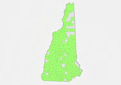
51 235 TAXING JURISDICTIONS
52 235 TAXING JURISDICTIONS 680,000 TAXABLE PROPERTIES

53 235 TAXING JURISDICTIONS 680,000 TAXABLE PROPERTIES 600,000 PARCELS

54
55 MOSAIC PARCEL MAP PROJECT NH DEPARTMENT OF REVENUE ADMINISTRATION - UNH TECHNOLOGY TRANSFER CENTER
56 MOSAIC PARCEL MAP PROJECT NH DEPARTMENT OF REVENUE ADMINISTRATION - UNH TECHNOLOGY TRANSFER CENTER PROPERTY TAX EQ
57 MOSAIC PARCEL MAP PROJECT NH DEPARTMENT OF REVENUE ADMINISTRATION - UNH TECHNOLOGY TRANSFER CENTER Data correlation and processing system Web based GIS platform PROPERTY TAX EQ
58 MOSAIC PARCEL MAP PROJECT NH DEPARTMENT OF REVENUE ADMINISTRATION - UNH TECHNOLOGY TRANSFER CENTER PROPERTY TAX EQ Data correlation and processing system Web based GIS platform.net, web based system Automated data streams
59 PROPERTY TAX EQ
60 MUNICIPALITIES PROPERTY TAX EQ
61 MUNICIPALITIES COUNTIES PROPERTY TAX EQ
62 MUNICIPALITIES COUNTIES STATE PROPERTY TAX EQ
63 MUNICIPALITIES COUNTIES STATE PROPERTY TAX EQ
64 MUNICIPALITIES COUNTIES STATE PROPERTY TAX EQ
65 MUNICIPALITIES COUNTIES STATE PROPERTY TAX EQ
66 MUNICIPALITIES COUNTIES STATE PROPERTY TAX EQ MUNICIPALITIES


67 MUNICIPALITIES COUNTIES STATE PROPERTY TAX EQ MUNICIPALITIES


68 MUNICIPAL PARCEL DATA 7% 3% GIS CAD Paper 90% Parcel records types as % of total records statewide Parcel map types by town


69 MUNICIPAL PARCEL DATA 11.0% 3.0% 7.0%0.2% 44.8% Vision Avitar Patriot Proval CLT CNP 34.0% CAMA records systems as % of total records statewide CAMA systems by town
70
71 HOW DID WE DO?
72 Edition I May 2010-June Taxing Jurisdictions 570,335 CAMA Records
73 Edition I May 2010-June 2011 Edition II June 2011-June Taxing Jurisdictions 570,335 CAMA Records 227 Taxing Jurisdictions 666,502 CAMA Records
74 Edition I May 2010-June 2011 Edition II June 2011-June 2012 Edition III June Taxing Jurisdictions 570,335 CAMA Records 227 Taxing Jurisdictions 666,502 CAMA Records 235 Taxing Jurisdictions 683,158 CAMA Records
75
76 Edition I May 2010-June Taxing Jurisdictions 389,704 Parcel Records
77 Edition I May 2010-June 2011 Edition II June 2011-June Taxing Jurisdictions 389,704 Parcel Records 225 Taxing Jurisdictions 560,723 Parcel Records
78 Edition I May 2010-June 2011 Edition II June 2011-June 2012 Edition III June Taxing Jurisdictions 389,704 Parcel Records 225 Taxing Jurisdictions 560,723 Parcel Records 189 Taxing Jurisdictions 441,720 Parcel Records
79 Edition I May 2010-June 2011 Edition II June 2011-June 2012 Edition III June Taxing Jurisdictions 389,704 Parcel Records 225 Taxing Jurisdictions 560,723 Parcel Records UPDATE 189 Taxing Jurisdictions 210 MUNICIPALITIES 441,720 Parcel Records 525,000 RECORDS

80 CAMA RECORD COLLECTION 700,000 NUMBER OF RECORDS 525, , ,000 Pilot Edition I Edition II Edition III WORK DAYS FROM START OF EDITION New Hampshire Mosaic 14
81 PARCEL MAP COLLECTION 600,000 NUMBER OF RECORDS 450, , ,000 Pilot Edition I Edition II Edition III WORK DAYS FROM START OF EDITION New Hampshire Mosaic 15
82 GIS DATA DISTRIBUTION WEB PLATFORM WEB MAPPING SERVICE (WMS)

83 GIS DATA DISTRIBUTION WEB PLATFORM
84 GIS DATA DISTRIBUTION WEB PLATFORM
85 GIS DATA DISTRIBUTION TORNADO EXAMPLE WEB PLATFORM
86 GIS DATA DISTRIBUTION WEB PLATFORM
87 GIS DATA DISTRIBUTION WEB PLATFORM WEB MAPPING SERVICE (WMS)
88 GIS DATA DISTRIBUTION WEB PLATFORM WEB MAPPING SERVICE (WMS)

89 GIS DATA DISTRIBUTION WEB PLATFORM WEB MAPPING SERVICE (WMS)
90 EQUALIZATION
91 EQUALIZATION
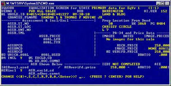


92 EQUALIZATION
93 NEW HAMPSHIRE MOSAIC DATA DRIVEN DECISION MAKING Google Yelp Facebook Geo BI Spatial Analytics ESRI The Vermont Digger West Collection The Tax Foundation The State of New Hampshire Plymouth State University Images Courtesy of: The University of New Hampshire Keene State College CDM Applied Geographics Autodesk Boston.com NEARC The Local Government Center Harvard University Twitter New Hampshire Mosaic 20

94 NEW HAMPSHIRE MOSAIC DATA DRIVEN DECISION MAKING New Hampshire Mosaic 20
Is Your GIS Ready For Grid Modernization? A State-of-the Industry Report
 Is Your GIS Ready For Grid Modernization? A State-of-the Industry Report Is Your GIS Ready For Grid Modernization? Survey Overview In the first quarter of 2019, Energy Acuity conducted a grid modernization
ASSESSMENT. Industry Solutions Harness the Power of GIS for Property Assessment
 ASSESSMENT Industry Solutions Harness the Power of GIS for Property Assessment Esri Canada has thousands of customers worldwide who are using the transforming power of GIS technology to collect, maintain,
Route 120 Build-out Analysis Using CommunityViz Scenario 360
 Route 120 Build-out Analysis Using CommunityViz Scenario 360 Jennifer Lingeman CommunityViz Technical Resource Center UNH Complex Systems Research Center jennifer.lingeman@unh.edu NH GRANIT o Central GIS
STATE GEOGRAPHIC INFORMATION DATABASE
 STATE GEOGRAPHIC INFORMATION DATABASE Data Information and Knowledge Management STATE GEOGRAPHIC INFORMATION DATABASE EXECUTIVE SUMMARY Utah has developed one of the most comprehensive statewide GIS resources
KING GEORGE COUNTY DEPARTMENT OF COMMUNITY DEVELOPMENT
 GIS REPORT 2016 KING GEORGE COUNTY DEPARTMENT OF COMMUNITY DEVELOPMENT Background The GIS (Geographic Information System) coordinator was hired in 2001 to develop a GIS for King George County. Prior to
Geospatial natural disaster management
 Geospatial natural disaster management disasters happen. are you ready? Natural disasters can strike almost anywhere at any time, with no regard to a municipality s financial resources. These extraordinarily
Creating a Staff Development Plan with Esri
 Creating a Staff Development Plan with Esri Michael Green David Schneider Guest Presenter: Shane Feirer, University of California Esri UC 2014 Technical Workshop Agenda What is a Staff Development Plan?
Strategic Plan
 2013-2015 Strategic Plan April 23, 2014 Introduction The Indiana Geographic Information Council's (IGIC) 2013-2015 Strategic Plan establishes a path of action to meet opportunities and challenges of applying
GIS Resources for Local Governments
 ISSUE PAPER SERIES GIS Resources for Local Governments February 2018 NEW YORK STATE TUG HILL COMMISSION DULLES STATE OFFICE BUILDING 317 WASHINGTON STREET WATERTOWN, NY 13601 (315) 785-2380 WWW.TUGHILL.ORG
ArcGIS for Desktop. ArcGIS for Desktop is the primary authoring tool for the ArcGIS platform.
 ArcGIS for Desktop ArcGIS for Desktop ArcGIS for Desktop is the primary authoring tool for the ArcGIS platform. Beyond showing your data as points on a map, ArcGIS for Desktop gives you the power to manage
for Effective Land Administration
 Role of Geospatial Technology in Land Information System(LIS) for Effective Land Administration Dr. Deb Jyoti Pal Sections Role of GIS in Land Records Proposed Work Flow Case Studies Role of GIS Creating
Corporate. Information. Railway Infrastructure Administrator. Year indracompany.com
 geospatial and mobility Corporate Geographic Information System of ADIF Railway Infrastructure Administrator. Year 2009-2010 Corporate Geographic Information System of ADIF ADIF. Spanish Administrator
UTAH S STATEWIDE GEOGRAPHIC INFORMATION DATABASE
 UTAH S STATEWIDE GEOGRAPHIC INFORMATION DATABASE Data Information and Knowledge Management NASCIO Awards 2009 STATE GEOGRAPHIC INFORMATION DATABASE B. EXECUTIVE SUMMARY Utah has developed one of the most
MODERNIZATION OF THE MUNICIPAL MAPPING USING HIGH END GNSS SYSTEM AND GIS SOFTWARE
 MODERNIZATION OF THE MUNICIPAL MAPPING USING HIGH END GNSS SYSTEM AND GIS SOFTWARE Mr. R. A. R. Khan Assistant Engineer, Sewerage Utility Management Centre (SUMC) Municipal Corporation Of Greater Mumbai
Write a report (6-7 pages, double space) on some examples of Internet Applications. You can choose only ONE of the following application areas:
 on some examples of Internet Applications. You can choose only ONE of the following application areas:") UPR 6905 Internet GIS Homework 1 Yong Hong Guo September 9, 2008 Write a report (6-7 pages, double space) on some examples of Internet Applications. You can choose only ONE of the following application
UPR 6905 Internet GIS Homework 1 Yong Hong Guo September 9, 2008 Write a report (6-7 pages, double space) on some examples of Internet Applications. You can choose only ONE of the following application
Sharing GIS to Empower the End User David Wray, Roanoke County, Virginia
 Sharing GIS to Empower the End User David Wray, Roanoke County, Virginia Sharing GIS to Empower the End User Roanoke County, Virginia Roanoke County, Virginia Population: 92,901 Area: 251 Square Miles
Digital Map of Mexico Platform and MxSIG. March 2017
 Digital Map of Mexico Platform and MxSIG March 2017 1 I. Digital Map of Mexico Platform Concept Evolution II. Digital Map of Mexico online Concept Capabilities Information available Other state units information
June 19 Huntsville, Alabama 1
 June 19 Huntsville, Alabama 1 Real-Time Geospatial Data: The Fusion of PI and ArcGIS Enabling Smarter Facilities Management OSIsoft and Esri Mapping and Location Analytics Platform Supporting Your Use
Creation of an Internet Based Indiana Water Quality Atlas (IWQA)
") Department of Environmental Management Creation of an Internet Based Water Quality Atlas (IWQA) May 4, 2005 IUPUI 1200 Waterway Blvd., Suite 100 polis, 46202-5140 Water Quality Atlas John Buechler, Neil
Department of Environmental Management Creation of an Internet Based Water Quality Atlas (IWQA) May 4, 2005 IUPUI 1200 Waterway Blvd., Suite 100 polis, 46202-5140 Water Quality Atlas John Buechler, Neil
NC Geospatial Data Archiving Project
 NC Geospatial Data Archiving Project 1. Frequency of Capture of Geospatial Data We seek your advice and experience in creating geospatial data snapshots for your archives -- versions of vector data and
Ministry of ICT of I.R.IRAN
 The ECO 8/6 mill km 2 10 Slamic countries ~330 mill people Oil, Gas, Industries,Tourism 2 Issue transformation in last decade Problem solving needs more integrated approach More interaction &complexity
GIS Building Communities beyond National Borders (Building Successful Spatial Data Infrastructures) Nick Land, ESRI Europe
 Nick Land, ESRI Europe") GIS Building Communities beyond National Borders (Building Successful Spatial Data Infrastructures) Nick Land, ESRI Europe UK worst flooding in the last 60 years 350,000 households without drinking water
GIS Building Communities beyond National Borders (Building Successful Spatial Data Infrastructures) Nick Land, ESRI Europe UK worst flooding in the last 60 years 350,000 households without drinking water
The Online Environmental Assessment Form Mapping Tool
 The Online Environmental Assessment Form Mapping Tool Presented by: Austin Fisher Fountains Spatial, Inc. New York State GIS Conference Saratoga Springs November 13 th, 2013 Content Background Information
Experiences and Directions in National Portals"
 FIG Seminar on e-land Administration Innsbruck/Austria 2-4 June 2004 "ESRI's Experiences and Directions in National Portals" Kevin Daugherty Cadastral/Land Records Manager ESRI Topic Points Technology
1. Which agency in your state is PRIMARILY responsible for archiving geospatial data and managing archived geo records? (choose one) nmlkj.
 nmlkj.") Survey Intro Kentucky, North Carolina, and Utah are partnering with the Library of Congress as part of the National Digital Information Infrastructure and Preservation Program (NDIIPP) to examine the current
Survey Intro Kentucky, North Carolina, and Utah are partnering with the Library of Congress as part of the National Digital Information Infrastructure and Preservation Program (NDIIPP) to examine the current
A Geographer s role in a Google Maps World. Jeremy Bartley ESRI
 A Geographer s role in a Google Maps World Jeremy Bartley ESRI 1 It is a good time to be a Geographer. 2 Microsoft, Google, Yahoo, and others are pushing geographic awareness to the general public Providing
From Geographics Stella to Bentley Map Stella Map. Kimmo Soukki, Account Manager Bentley Finland
 From Geographics Stella to Bentley Map Stella Map Kimmo Soukki, Account Manager Bentley Finland This presentation Stella? Why migrate? New Bentley Stella Map - How it is done? Data migration Bonuses? What
Open spatial data infrastructure
 Open spatial data infrastructure a backbone for digital government Thorben Hansen Geomatikkdagene 2018 Stavanger 13.-15. mars Spatial Data Infrastructure definition the technology, policies, standards,
Case study: Nairobi City County CBD and its Environs. Presenter: Peter Patrick Kioko. Supervisor: Mr. B.M. Okumu
 Case study: Nairobi City County CBD and its Environs Presenter: Peter Patrick Kioko Supervisor: Mr. B.M. Okumu OUTLINE Introduction Problem Statement Objectives Area of study Application of GIS Methodology
Digital Tax Mapping Present and Future. Kurt Donaldson
 Digital Tax Mapping Present and Future Kurt Donaldson WV GIS Technical Center Mission - To provide focus, direction and leadership to users of geographic information systems (GIS), digital mapping and
2007 / 2008 GeoNOVA Secretariat Annual Report
 2007 / 2008 GeoNOVA Secretariat Annual Report Prepared for: Assistant Deputy Minister and Deputy Minister of Service Nova Scotia and Municipal Relations BACKGROUND This report reflects GeoNOVA s ongoing
Bentley Map Advancing GIS for the World s Infrastructure
 Bentley Map Advancing GIS for the World s Infrastructure Presentation Overview Why would you need Bentley Map? What is Bentley Map? Where is Bentley Map Used? Why would you need Bentley Map? Because your
ArcGIS. for Server. Understanding our World
 ArcGIS for Server Understanding our World ArcGIS for Server Create, Distribute, and Manage GIS Services You can use ArcGIS for Server to create services from your mapping and geographic information system
Geography for the 2020 Round of Census
 Boundaries Key Census Data EA Id Population Male Female EA Id Area EA Id Num HH Avg HH size Geography for the 2020 Round of Census Linda Peters, Esri lpeters@esri.com Integration of Statistical and Geospatial
Developing a Subdivision Build- Out Study and Site Suitability Tool; Enabling Access Through a Web GIS Application
 Developing a Subdivision Build- Out Study and Site Suitability Tool; Enabling Access Through a Web GIS Application DOUG SEXTON GEOG 596A SUMMER 2017 ADVISOR: DR. JAMES O BRIEN Project Outline Introduction
SA Geospatial Analysis Platform (GAP) Methodology*, collaborators & data sources
 Methodology*, collaborators & data sources") SA Geospatial Analysis Platform (GAP) Methodology*, collaborators & data sources Mesoframe CSIR, dti, the Presidency & GTZ Demarcation of South Africa into a grid of 50 Km 2 mesozones, nested within important
SA Geospatial Analysis Platform (GAP) Methodology*, collaborators & data sources Mesoframe CSIR, dti, the Presidency & GTZ Demarcation of South Africa into a grid of 50 Km 2 mesozones, nested within important
GROUP ON INTEGRATION OF STATISTICAL AND GEOSPATIAL INFORMATION GT-IIEG
 UN-GGIM: Americas WORKING GROUP ON INTEGRATION OF STATISTICAL AND GEOSPATIAL INFORMATION GT-IIEG Bogotá, Colombia August, 2018 www.dane.gov.co Working group GT-IIEG Objective: To raise awareness and promote
SOLUTIONS ADVANCED GIS. TekMindz are developing innovative solutions that integrate geographic information with niche business applications.
 ADVANCED GIS SOLUTIONS TekMindz are developing innovative solutions that integrate geographic information with niche business applications. TEK INDZ TM GIS Services Overview At the leading edge of geospatial
GIS at the Regional District
 GIS at the Regional District Amanda Spendiff Outline Introduction What is a Regional District? Our GIS department What does the GIS department do? Data management & mapping 9-1-1 fire/dispatch support
Bentley Map Advancing GIS for the World s Infrastructure
 Bentley Map Advancing GIS for the World s Infrastructure Presentation Overview Why would you need Bentley Map? What is Bentley Map? Where is Bentley Map Used? Red text signifies new things in Bentley Map
Evaluating e-government : implementing GIS services in Municipality
 Evaluating e-government : implementing GIS services in Municipality Municipality of Thessaloniki - G.I.S. Unit Misirloglou Symeon Head of the GIS Unit ESRI UC - 2016 The GIS Section - subset of the department
Esri and GIS Education
 Esri and GIS Education Organizations Esri Users 1,200 National Government Agencies 11,500 States & Regional Agencies 30,800 Cities & Local Governments 32,000 Businesses 8,500 Utilities 12,600 NGOs 11,000
Iowa Department of Transportation Office of Transportation Data GIS / CAD Integration
 Iowa Department of Transportation Office of Transportation Data GIS / CAD Integration From GIS data to CAD graphics - Iowa DOT's workflow utilizing GeoMedia and MicroStation to develop map products. Mark
Challenges in Geospatial Policy Formulation and Programme Management
 Challenges in Geospatial Policy Formulation and Programme Management Luiz Paulo Souto Fortes, PhD An Exchange with the Geospatial Industry for UN-GGIM Seoul, October 23, 2011 BRAZIL Land area 8,514,876.599
Cartographic and Geospatial Futures
 Cartographic and Geospatial Futures 1. Web Cartography, WebGIS, & Virtual Globes--New Roles for Maps, GIS, and GIS professionals 2. Map Mashups, the Neo Neo-geography Movement, & Crowd-sourcing Geospatial
Techniques for Science Teachers: Using GIS in Science Classrooms.
 Techniques for Science Teachers: Using GIS in Science Classrooms. After ESRI, 2008 GIS A Geographic Information System A collection of computer hardware, software, and geographic data used together for
Innovation. The Push and Pull at ESRI. September Kevin Daugherty Cadastral/Land Records Industry Solutions Manager
 Innovation The Push and Pull at ESRI September 2004 Kevin Daugherty Cadastral/Land Records Industry Solutions Manager The Push and The Pull The Push is the information technology that drives research and
Qatar s Nation-Wide GIS Cooperation on Local and Regional Levels
 Qatar s Nation-Wide GIS Cooperation on Local and Regional Levels Dr. Mohammad Abd El-Wahab Hamouda GIS Consultant & Chairman of GIS Coordinators Group The Center for GIS State of Qatar Second High Level
Discovery and Access of Geospatial Resources using the Geoportal Extension. Marten Hogeweg Geoportal Extension Product Manager
 Discovery and Access of Geospatial Resources using the Geoportal Extension Marten Hogeweg Geoportal Extension Product Manager DISCOVERY AND ACCESS USING THE GEOPORTAL EXTENSION Geospatial Data Is Very
Geographic Information System Visualization and Analysis for Assessment in Wisconsin
 WAAO Quarterly Meeting June 23, 2017 Adam Dorn City of Oshkosh IT Division Geographic Information System Visualization and Analysis for Assessment in Wisconsin Outline Introduction Data Maintenance Who
ENVI for ArcGIS TURN GEOSPATIAL IMAGERY INTO USEFUL INFORMATION FOR YOUR GIS ON THE DESKTOP, FOR MOBILE DEVICES, AND IN THE CLOUD HarrisGeospatial.
 ENVI for ArcGIS TURN GEOSPATIAL IMAGERY INTO USEFUL INFORMATION FOR YOUR GIS ON THE DESKTOP, FOR MOBILE DEVICES, AND IN THE CLOUD HarrisGeospatial.com ENVI FOR ArcGIS BENEFITS Use the full power of ENVI
The Use of Geographic Information Systems (GIS) by Local Governments. Giving municipal decision-makers the power to make better decisions
 by Local Governments. Giving municipal decision-makers the power to make better decisions") The Use of Geographic Information Systems (GIS) by Local Governments Giving municipal decision-makers the power to make better decisions Case Study: Examples of GIS Usage by Local Governments in North
The Use of Geographic Information Systems (GIS) by Local Governments Giving municipal decision-makers the power to make better decisions Case Study: Examples of GIS Usage by Local Governments in North
DP Project Development Pvt. Ltd.
 Dear Sir/Madam, Greetings!!! Thanks for contacting DP Project Development for your training requirement. DP Project Development is leading professional training provider in GIS technologies and GIS application
Kansas Next Generation 911
 Kansas Next Generation 911 Kansas Next Generation 911 the largest IT project in state history* the largest GIS project in state history* * could be...has not been fact checked Project overview Primary
GIS AND GEOSPATIAL INFORMATION MANAGEMENT FOR URBAN PLANNING AND LAND MANAGEMENT IN SAUDI ARABIA
 GIS AND GEOSPATIAL INFORMATION MANAGEMENT FOR URBAN PLANNING AND LAND MANAGEMENT IN SAUDI ARABIA Manal Al-Hajji GIS Consultant Oman Geospatial Forum Oman April 10-11, 2017 CONTENTS 1. Future Saudi Cities
TheEuropean Location Framework
 TheEuropean Location Framework Presentation to: Author: Date: TN-ITS/INSPIRE session at INSPIRE Conference Olaf Magnus Østensen, ELF co-ordinator 18 June2014 The ELF project 15 national mapping authorities
ArcGIS for INSPIRE. Marten Hogeweg
 ArcGIS for INSPIRE Marten Hogeweg Please Take Our Survey on the App Download the Esri Events app and find your event Select the session you attended Scroll down to find the feedback section Complete answers
Subwatersheds File Geodatabase Feature Class
 Subwatersheds File Geodatabase Feature Class Tags subwatersheds, watersheds Summary shows the subwatersheds of the 9 watersheds in TRCA's jurisdiction Description sub watershed boundaries in TRCA jurisdiction.
The Social Life of Location. David Sonnen September 2008
 The Social Life of Location David Sonnen September 2008 Three Transformations Traditional Cartography -- 2300 B.C. - ~ 1980 Maps represent location and attributes Portable, persistent communication/ reference
Key Points Sharing fosters participation and collaboration Metadata has a big role in sharing Sharing is not always easy
 Sharing Resources Geoff Mortson esri, Inc. SDI Solutions Team Key Points Sharing fosters participation and collaboration Metadata has a big role in sharing Sharing is not always easy Data Sharing is Good
The Integrated Ge spatial Information Framework to the strengthening of NSDI, Mongolia
 Young Geospatial Professionals Summit 21 NOV 2018 The Integrated Ge spatial Information Framework to the strengthening of NSDI, Mongolia BAYARMAA ENKHTUR Geospatial information and technology department
Managing Parcels in ArcGIS 10
 Managing Parcels in ArcGIS 10 ArcGIS Geodatabase Editing Workflows Editing Maps Tim Hensley Esri Solution Engineer Karen Lowrey Esri Geospatial Analyst Basemaps Public Access Value Analysis ArcGIS 10 Parcel
Enterprise Linear Referencing at the NYS Department of Transportation
 Enterprise Linear Referencing at the NYS Department of Transportation One Highway Network to Support Many Business Processes May 9, 2018 May 9, 2018 2 Agenda An overview of Linear Referencing How NYSDOT
Why You Should Invest in an Address Point Layer
 A GeoComm White Paper June 6, 2012 601 West Saint Germain St. St. Cloud, MN 56301 1.866.GEO.COMM Identifying 9-1-1 Caller Location By John Brosowsky, GeoComm Product Development Director Nathan Ekdahl,
INSPIRing Geospatial Framework For Local Administrations
 This project is financed by the European Union and the Republic of Turkey Presented at the FIG Congress 2018, May 6-11, 2018 in Istanbul, Turkey National Programme for Turkey 2010 Instrument for Pre-Accession
Exploring GIS Potential for Northwestern Ontario Land Information Ontario
 Exploring GIS Potential for Northwestern Ontario Land Information Ontario May 13, 2015 The LIO Vision LIO Vision: That all geographic information about Ontario is fully integrated and accessible LIO Goal:
Leveraging ArcGIS Server Technology
 Leveraging ArcGIS Server Technology A Local Government Approach Virginia Johnston GIS Systems Analyst Virginia Beach 39 th Largest city in the United States 438,000 Residents City by the Sea Located in
USING TECHNOLOGY TO SHARE GIS David Wray, Roanoke County, Virginia
 USING TECHNOLOGY TO SHARE GIS David Wray, Roanoke County, Virginia Using Technology to Share GIS Roanoke County, Virginia Roanoke County, Virginia Population: 92,901 Area: 251 Square Miles Protected Areas:
The Underutilization of GIS & How to Cure It. Adam Carnow Esri
 The Underutilization of GIS & How to Cure It Adam Carnow Esri What is GIS? A framework to organize, communicate, and understand the science of our world Business Intelligence (BI) is the set of
GIS-T 2010 Building a Successful Geospatial Data Sharing Framework: A Ohio DOT Success Story
 GIS-T 2010 Building a Successful Geospatial Data Sharing Framework: A Ohio DOT Success Story ODOT District 2 GIS John Puente District 1 GIS Coordinator\ Planning Administrator 2 Interoperability 3 District
2006 GIS-T T Symposium Columbus Ohio
 2006 GIS-T T Symposium Columbus Ohio Creating a Location Based Response System Using ESRI Technology Brian Stevens, CP Woolpert, Inc. Agenda Introduction What is LBRS? History Specifications Proposed Method
Critical Area Mapping Update Project St. Mary s County Town Hall April 8th, :30 p.m.
 Critical Area Mapping Update Project St. Mary s County Town Hall April 8th, 2019 6:30 p.m. Critical Area Commission for the Chesapeake and Atlantic Coastal Bays St. Mary s County What Is the Critical Area
Office of Technology Partnerships GIS Collaboration
 Office of Technology Partnerships GIS Collaboration State GIS Update April 21, 2017 Mark Holmes, GISP Outline MGF Upgrade Project Census Programs Imagery Update LiDAR Update Open Discussion 2 MGF Background
Maryland Transit Administration (MTA) Bus Accident Mapping and Analysis Application
 Bus Accident Mapping and Analysis Application") Maryland Transit Administration (MTA) Bus Accident Mapping and Analysis Application Ralign Wells, MTA Administrator Bernadette Bridges, MTA Chief Safety Officer Office of Safety, Quality Assurance, and
Maryland Transit Administration (MTA) Bus Accident Mapping and Analysis Application Ralign Wells, MTA Administrator Bernadette Bridges, MTA Chief Safety Officer Office of Safety, Quality Assurance, and
Tools to Assess Local Health Needs. Richard Leadbeater, Esri NACo 2011 Healthy Counties Forum December 1, 2011
 Tools to Assess Local Health Needs Richard Leadbeater, Esri NACo 2011 Healthy Counties Forum December 1, 2011 Richard Leadbeater currently holds the position of Industry Solutions Manager with Esri. He
GIS in Weather and Society
 GIS in Weather and Society Olga Wilhelmi Institute for the Study of Society and Environment National Center for Atmospheric Research WAS*IS November 8, 2005 Boulder, Colorado Presentation Outline GIS basic
Enhancing Parcel Data In Colleton County. February 10, 2009
 Enhancing Parcel Data In Colleton County GIS & CAMA Conference February 10, 2009 Introductions Bruce T. Harper Technology Director Colleton County, SC Bill Wetzel National GIS Account Manager The Sidwell
Local Government Basemaps using ArcGIS
 Local Government Basemaps using ArcGIS Steve Grisé Scott Oppmann Tuesday, July 14, 10:15-11:30am SDCC 30B Topics Basemaps for Local Government Essential Application-Driven New Ideas Design Strategies Discussion
GIS Geographical Information Systems. GIS Management
 GIS Geographical Information Systems GIS Management Difficulties on establishing a GIS Funding GIS Determining Project Standards Data Gathering Map Development Recruiting GIS Professionals Educating Staff
Maryland Transit Administration (MTA) Bus Accident Mapping and Analysis Application
 Bus Accident Mapping and Analysis Application") Maryland Transit Administration (MTA) Bus Accident Mapping and Analysis Application Ralign Wells, MTA Administrator Bernadette Bridges, MTA Chief Safety Officer Office of Safety, Quality Assurance, and
Maryland Transit Administration (MTA) Bus Accident Mapping and Analysis Application Ralign Wells, MTA Administrator Bernadette Bridges, MTA Chief Safety Officer Office of Safety, Quality Assurance, and
Harmonizing spatial databases and services at local and regional level
 Harmonizing spatial databases and services at local and regional level A. Ionita 1, M. Caian 2, V. Vassilev 3, V. Craciunescu 2, I. Nedelcu 4 1 Research Institute for Artificial Intelligence, Bucuresti,
Coastal Response Research Center. Nancy Kinner University of New Hampshire (UNH) Michele Jacobi NOAA ORR. September 27, 2007
 Michele Jacobi NOAA ORR. September 27, 2007") Coastal Response Research Center Nancy Kinner University of New Hampshire (UNH) Michele Jacobi NOAA ORR September 27, 2007 1 Coastal Response Research Center (CRRC) CRRC is partnership between NOAA s Office
Coastal Response Research Center Nancy Kinner University of New Hampshire (UNH) Michele Jacobi NOAA ORR September 27, 2007 1 Coastal Response Research Center (CRRC) CRRC is partnership between NOAA s Office
Smart Data Collection and Real-time Digital Cartography
 Smart Data Collection and Real-time Digital Cartography Yuji Murayama and Ko Ko Lwin Division of Spatial Information Science Faculty of Life and Environmental Sciences University of Tsukuba IGU 2013 1
UN-GGIM: User case studies ISRAEL
 UNGGIM: User case studies ISRAEL ISRAEL GIS for 2008 Integrated Population Census GIS was used as a main infrastructure for the 2008 Israeli integrated census of population The Integrated Census is based
ArcGIS Platform For NSOs
 ArcGIS Platform For NSOs Applying GIS and Spatial Thinking to Official Statistics Esri UC 2014 Demo Theater Applying GIS at the NSO Generic Statistical Business Process Model (GSBPM) 1 Specify Needs 2
[DOC] GIS TRANING OPERATION MANUAL EBOOK
![[DOC] GIS TRANING OPERATION MANUAL EBOOK](/thumbs/79/79133035.jpg "[DOC] GIS TRANING OPERATION MANUAL EBOOK") 23 December, 2017 [DOC] GIS TRANING OPERATION MANUAL EBOOK Document Filetype: PDF 157.53 KB 0 [DOC] GIS TRANING OPERATION MANUAL EBOOK Learn GIS for free online from these university and institution. GIS
23 December, 2017 [DOC] GIS TRANING OPERATION MANUAL EBOOK Document Filetype: PDF 157.53 KB 0 [DOC] GIS TRANING OPERATION MANUAL EBOOK Learn GIS for free online from these university and institution. GIS
Regional GIS Presentation for Small and Large Jurisdictions. Michelle E. Fults GIS Manager January 8, 2009
 Regional GIS Presentation for Small and Large Jurisdictions Michelle E. Fults GIS Manager January 8, 2009 Presentation Contributions from Juston Manville Henrico County Kevin Nelson Hanover County Mark
A Web Service based U.S. Cropland Visualization, Dissemination and Querying System
 A Web Service based U.S. Cropland Visualization, Dissemination and Querying System Rick Mueller and Zhengwei Yang USDA/National Agricultural Statistics Service Weiguo Han and Liping Di GMU/Center for Spatial
The Emerging Role of Enterprise GIS in State Forest Agencies
 The Emerging Role of Enterprise GIS in State Forest Agencies Geographic Information System (GIS) A geographic information system (GIS) is a computer software system designed to capture, store, manipulate,
Implementing INSPIRE Geoportal in Turkey
 Implementing INSPIRE Geoportal in Turkey Gencay SERTER City and Regional Planner 1 Presentation Plan Introduction INSPIRE and Turkey Importance of al Spatial Planning Portal Logical&Legal Hierarchy GeoPortal
Google Maps and Beyond
 Google Maps and Beyond Aaron Paul First American Title apaul@firstam.com 2015 APRA Symposium Association of Professional Reserve Analysts May 2 nd, 2015 Google Maps and Beyond - Overview Business case
IDEBarcelona: Cooperating for a Smart Region Infrastructure
 IDEBarcelona: Cooperating for a Smart Region Infrastructure Marta Codinachs Serra Diputació de Barcelona Territory and Sustainability Area Territorial Information Systems Department SMART CITY EXPO WORLD
GIS (GEOGRAPHICAL INFORMATION SYSTEMS) AS A FACILITATION TOOL FOR SUSTAINABLE DEVELOPMENT IN AFRICA
 AS A FACILITATION TOOL FOR SUSTAINABLE DEVELOPMENT IN AFRICA") GIS (GEOGRAPHICAL INFORMATION SYSTEMS) AS A FACILITATION TOOL FOR SUSTAINABLE DEVELOPMENT IN AFRICA a presentation by Elizabeth Hicken GDEST Conference on Geospatial Sciences for Sustainable Development
GIS (GEOGRAPHICAL INFORMATION SYSTEMS) AS A FACILITATION TOOL FOR SUSTAINABLE DEVELOPMENT IN AFRICA a presentation by Elizabeth Hicken GDEST Conference on Geospatial Sciences for Sustainable Development
Building a National Data Repository
 Building a National Data Repository Mladen Stojic, Vice President - Geospatial 1/30/2013 2012 Intergraph Corporation 1 Information has meaning and gives power only when shared and distributed. Information,
WELCOME & INTRODUCTIONS
 GIS Monroe Geographic Information System January 31, 2018 WELCOME & INTRODUCTIONS Chip Thomas, Ritter GIS Sarah Schrader, Acct. Mgr., ESRI Chris Beyett, Solutions Engineer, ESRI Colleen Hinzmann, IT Director,
VT STATEWIDE PROPERTY PARCEL MAPPING PROJECT & PROGRAM
 VT STATEWIDE PROPERTY PARCEL MAPPING PROJECT & PROGRAM BUILDING A FOUNDATIONAL MAPPING DATA LAYER Leslie Pelch, VCGI April 2017 WHAT ARE THE STATEWIDE PROPERTY PARCEL MAPPING PROJECT & PROGRAM? A project
University of New Hampshire Scholars' Repository
 University of New Hampshire University of New Hampshire Scholars' Repository Center for Coastal and Ocean Mapping Center for Coastal and Ocean Mapping 3-2009 Environmental Response Management Application
GIS Quick Facts. CIVL 1101 GIS Quick Facts 1/5.
 CIVL 1101 1/5 What is GIS? Geographic Information Systems (GIS) provide a platform for displaying and analyzing spatial data. GIS systems allow you to view multiple layers of data simultaneously. GIS is
MAPPS 2012 Geospatial Products and Services Excellence Awards Awards Entry Form
 MAPPS 2012 Geospatial Products and Services Excellence Awards 2012 Awards Entry Form Please include a copy of this document with the project/product submission Entry Information Submission Number: 1741558
Environmental Response Management Application
 Environmental Response Management Application Coastal Response Research Center Nancy Kinner, Michele Jacobi, Rob Braswell, Kurt Schwehr & Amy Merten RRT III May 14, 2008 1 Talk Outline Overview of Center