Assessing Large-Scale Spatial Distribution of Seagrasses in the Loxahatchee River
|
|
|
- Emory Singleton
- 5 years ago
- Views:
Transcription


1 Assessing Large-Scale Spatial Distribution of Seagrasses in the Loxahatchee River David Sabin & Albrey Arrington Wildpine Ecological Laboratory Loxahatchee River District

2 Why Assess Seagrass? Seagrass is: an essential fish habitat, because they are necessary to ensure healthy fisheries; a valued ecosystem component, because they are a dominant, habitat forming community; excellent indicators.


3 Loxahatchee River Seagrass courtesy South Florida Water Management District courtesy South Florida Water Management District

4 Prior Seagrass Mapping Results Seagrass mapping is a valuable approach to assess the spatial extent, distribution, and composition of existing seagrass beds. Prior Efforts: 1980 USGS 1985 PBC Health Dept. (Gain) 1990 Jupiter Inlet District (Loss) 1996 Jupiter Inlet District (Loss) 1998 Jupiter Inlet District (Gain) 2000 Jupiter Inlet District (Gain) 2003 Avineon (Gain) 2007 Loxahatchee River District (Gain) 1985 Data


5 We wanted more precise data than photo interpretation could provide Image 2007 Image Sometimes you time the tide right and sometimes you re close

6 Only 91 acres were found during Seagrass Data Miles

7 Open with Human Scale Folded Up Our Quadzilla Approach


8 Kayak Bouys Additional GPS Equipment Data sheets
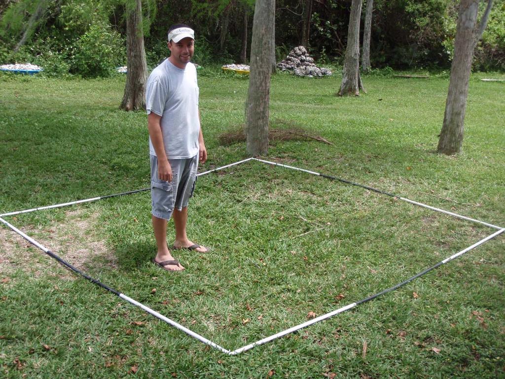
9
10 Quadzilla Method Example Shoal grass (HWRI) Turtle grass (Ttes) 5 3 DS 8/7/ PP Data m 2 quadrat was deployed using a random stratified design. 2. Each species was scored according to the number of 1m 2 cells in which it was present, and bare substrate was scored as the total number of 1m 2 cells in which no seagrass was present. 3. Spatial coordinates and ancillary data were recorded.

11 Notes How Quadrat Approximately 1100 sites were assessed during the summer of 2007 River was segmented to make sure we had full coverage Historical data and thorough knowledge of river helped in looking in right areas

12 2007 All Spots
13 Seagrass Distribution: All Samples 80% n =1085 Samples 70% Percent of Samples 60% 50% 40% 30% 20% 10% 0% No grass Johnson's Shoal Paddle Manatee Turtle Star grass not found in 2007
14 Northwest Fork North Fork Southwest Fork Central Embayment
15 Seagrass Distribution 80% 70% No grass Johnson's Shoal Paddle Manatee Turtle Percent of Samples 60% 50% 40% 30% 20% 10% 0% Central Embayment North Fork Northwest Fork Southwest Fork
 in the neighborhood of each cell being estimated.")
16 Spatial Analysis ArcGIS 9.2 with Spatial Analysis extension was used. Inverse Distance Weighted (IDW) was used to analyze the whole area based on our actual samples. IDW estimates cell values by averaging the values of the data points (samples) in the neighborhood of each cell being estimated. The closer a point is to the center of the cell being estimated, the more influence, or weight, it has in the averaging process. Example: The figure to the right shows actual samples (small points) and IDW estimates (color gradients) for an actual segment of our study area.

17 Grass- 496 Acres
18 Johnson s Acres


19 Shoal -366 Acres Paddle 104 Acres Manatee 22 Acres Turtle -17 Acres


20 Methodological Issues Lack of equipment slows process down Bias when laying down quadrat under water Poor water clarity makes work difficult Physically demanding during strong current and at deep sites Approach evolved through time to be more efficient and thorough ArcGIS Analysis issues Whenever GPS had problems points had to be re-sampled.
.")
21 Conclusion 2007 study vs 2003 showed seagrass gain True gain plus gain from new technique Learned a lot more by looking at the whole river unlike pervious years, when we only assessed certain areas. We need to generate dock coverage and clip docks from area analyzed so we don t overestimate occurrence of seagrass (i.e., under docks). Spatial extent of seagrass likely will be overestimated if bare (sand) areas are not sufficiently assessed.


22 Acknowledgements Questions Capt. Dave We did have some bad Days!! Staff and volunteers who helped sure know the river. A lot of work so we are seeking volunteers for 2010 work. Lorene Jerry Sue
Aquatic Vegetation Density Mapping BioBase 2015 Report
 Aquatic Vegetation Density Mapping BioBase 2015 Report Written by: Sarah Mielke PLSLWD Monitoring Assistant Edited by: Jaime Rockney, Water Resources Specialist June 2016 Contents Introduction... 1 Objectives...
SEAGRASS COVERAGE TRENDS IN THE INDIAN RIVER LAGOON SYSTEM
 Biological Sciences SEAGRASS COVERAGE TRENDS IN THE INDIAN RIVER LAGOON SYSTEM R. W. VIRNSTEIN *,J.S.STEWARD, AND L. J. MORRIS St. Johns River Water Management District, Palatka, FL 32178 ABSTRACT: We
Lower South Fork McKenzie River Floodplain Enhancement Project
 Lower South Fork McKenzie River Floodplain Enhancement Project McKenzie River Ranger District Willamette National Forest Project Location The project is located in the South Fork McKenzie River Watershed,
MAINTENANCE DREDGE BENTHIC ASSESSMENT SUNSET POINT FARM LLC LONG POINT KEY MONROE COUNTY, FLORIDA. Prepared by:
 MAINTENANCE DREDGE BENTHIC ASSESSMENT SUNSET POINT FARM LLC LONG POINT KEY MONROE COUNTY, FLORIDA Prepared by: December 11, 2016 INTRODUCTION The owners of the Sunset Point Farms LLC, located on the northern
Habitat Assessment. Peggy Compton UW-Extension Water Action Volunteers Program Coordinator
 Habitat Assessment Peggy Compton UW-Extension Water Action Volunteers Program Coordinator Adapted from a presentation by Jean Unmuth, Water Quality Biologist, WI DNR dnr.wi.gov www.uwex.edu erc.cals.wisc.edu
Topographic Maps Lab 1
 Topographic Maps Lab 1 I. Objectives 1. Construct a material model of typical terrain found in a landscape. 2. Construct a topographic map corresponding to the terrain model. 3. Learn how to interpret
Joint Federal Agency Submerged Aquatic Vegetation Survey Guidance for the New England Region Updated August 11, 2016
 Joint Federal Agency Submerged Aquatic Vegetation Survey Guidance for the New England Region Updated August 11, 2016 FOREWORD This guidance is the result of on-going interagency collaboration between the
Analysis of Environmental Impacts from the Port of Miami Expansion. Julienne Beblo
 Analysis of Environmental Impacts from the Port of Miami Expansion Julienne Beblo 6.28.16 The Port of Miami One of the most prominent ports for global tourism and commerce Contributes $28 billion/yr to
Mississippi River and Tributaries Project Mississippi River Geomorphology and Potamology Program
 Mississippi River and Tributaries Project Mississippi River Geomorphology and Potamology Program Barb Kleiss, Mississippi Valley Division Freddie Pinkard, Vicksburg District June, 2016 Program Objectives
CORRELATION ANALYSIS BETWEEN PALAEMONETES SHRIMP AND VARIOUS ALGAL SPECIES IN ROCKY TIDE POOLS IN NEW ENGLAND
 CORRELATION ANALYSIS BETWEEN PALAEMONETES SHRIMP AND VARIOUS ALGAL SPECIES IN ROCKY TIDE POOLS IN NEW ENGLAND Douglas F., Department of Biology,, Worcester, MA 01610 USA (D@clarku.edu) Abstract Palamonetes
The original tiered SAV distribution restoration targets
 CHAPTER VIII Chesapeake Bay SAV Distribution Restoration Goals and Targets The original tiered SAV distribution restoration targets for Chesapeake Bay were first published in the 1992 SAV technical synthesis
Weekly summary of Tropic101x as posted by student Lucia_Agudelo
 Weekly summary of Tropic101x as posted by student Lucia_Agudelo With minor grammatical and content edits by Tropic101x team Summary of Week 6 FIELD METHODS LECTURE 6.1.1 Being able to measure the distribution,
Notes and Summary pages:
 Topographic Mapping 8.9C Interpret topographical maps and satellite views to identify land and erosional features and predict how these shapes may be reshaped by weathering ATL Skills: Communication taking
Application of GIS and remote sensing in conservation of vernal pools
 Priyanka Patel NRS 509 12/16/2014 Application of GIS and remote sensing in conservation of vernal pools Vernal pools are small temporary water bodies that contain water for some parts of the year. They
Trinity River Sub basin Environmental Flows Data Report for Quality Assured Data Collected between September 1, 2014 and June 30, 2015.
 Trinity River Sub basin Environmental Flows Data Report for Quality Assured Data Collected between September 1, 2014 and June 30, 2015 Final Report August 1, 2015 Trinity River Sub basin Environmental
17-20 November 2007 Incidental Take Monitoring Methodology and Results
 Sample Site Selection Protocol 17-20 November 2007 Incidental Take Monitoring Methodology and Results On 16 November 2007, the U.S. Fish and Wildlife Service (USFWS) provided the USACE Mobile District
OPIHI Equipment: Introduction to Transects and Quadrats
 OPIHI Equipment: Introduction to Transects and Quadrats OPIHI uses commercially purchased transects. OPIHI uses 12 square PVC quadrats. The quadrats are strung with fishing line to create 2 intersections,
Photo 1: Assen Brothers Splash Dam in 1912, Middle Creek Oregon. Photo courtesy of Coos County Historical Society
 Spatial Correlation of Historical Salmon Spawning Sites to Historical Splash Dam Locations in the Oregon Coast Range By Rebecca Miller Geo 565 Option 2 Final Introduction Photo 1: Assen Brothers Splash
OCEAN ZONES. 1. Intertidal Zone 2. Near-Shore Zone 3. Open-Ocean Zone
 OCEAN ZONES 1. Intertidal Zone 2. Near-Shore Zone 3. Open-Ocean Zone Where the Ocean Meets the Land (Place) Intertidal Zone The intertidal zone is the area between the high- and low-tide lines. At high
OCEAN ZONES. 1. Intertidal Zone 2. Near-Shore Zone 3. Open-Ocean Zone
 OCEAN ZONES 1. Intertidal Zone 2. Near-Shore Zone 3. Open-Ocean Zone Where the Ocean Meets the Land (Place) Intertidal Zone The intertidal zone is the area between the high- and low-tide lines. At high
Seagrass Transplantation & Environmental & Marine Consulting Services, Inc. Drew Campbell, Vice President & Lead Scientst.
 Indian River Lagoon Symposium Seagrass Transplantation & Project Considerations Environmental & Marine Consulting Services, Inc. Drew Campbell, Vice President & Lead Scientst March 26 th, 2013 Regulatory
A Comparison of the Social Valuation of Ecosystem Services in Urban and Rural Contexts
 A Comparison of the Social Valuation of Ecosystem Services in Urban and Rural Contexts Jarrod L. Loerzel College of Charleston Zachary D. Cole University of Florida Presentation Map 1. What is SolVES?
LAKE SURVEY REPORT. Fisheries Management. DOW Number: Survey ID Date: 07/31/2017. Lake Identification. Lake Location. Legal Descriptions
 Fisheries Management LAKE SURVEY REPORT Lake Name: Kroon Survey Type: Targeted Survey DOW Number: 13-0013-00 Survey ID Date: 07/31/2017 Lake Identification Alternate Lake Name: N/A Primary Lake Class ID:
Bob Van Dolah. Marine Resources Research Institute South Carolina Department of Natural Resources
 Bob Van Dolah Marine Resources Research Institute South Carolina Department of Natural Resources Shoreline Change Will Occur! On our front beaches where it is not easy to retreat Shoreline Change Will
Citizen Science Actions AIS Shoreline Survey Blocking Zebra Mussels Ice in, Ice off. Janet Andersen
 Citizen Science Actions AIS Shoreline Survey Blocking Zebra Mussels Ice in, Ice off Janet Andersen Shoreline search for new Aquatic Invasive Plants NYS DEC NYSFOLA Janet Andersen Shoreline Search Topics
ASEAN Trans-Boundary Marine Debris and Consortium for Indonesia Oceanic Research
 ASEAN Trans-Boundary Marine Debris and Consortium for Indonesia Oceanic Research Dr. Mutiara Rachmat Putri Research Group of Oceanography Institut Teknologi Bandung, INDONESIA Regional Workshop in support
Learning Objectives: I can identify and interpret river flows and directions.
 Learning Objectives: I can identify and interpret river flows and directions. Bellringer Review: Check for Understanding Questions: 1 2 What Are The Key Parts Of A River s Anatomy? In your data notebooks
South Florida Coastal Storm Surge and Mapping Study
 South Florida Coastal Storm Surge and Mapping Study Presented by Christopher Bender, Ph.D., P.E., D.CE June 2, 2015 Presentation Overview FEMA risk studies outline Overview South Florida surge study Work
REPORT OF INVESTIGATION NO. 107 A SEDIMENTOLOGICAL ANALYSIS OF SEAGRASS BED SUBSTRATE FROM BAY COUNTY, FLORIDA
 REPORT OF INVESTIGATION NO. 107 A SEDIMENTOLOGICAL ANALYSIS OF SEAGRASS BED SUBSTRATE FROM BAY COUNTY, FLORIDA Daniel C. Phelps, (P.G. # 1203), Michelle M. Lachance and James G. Sparr TABLE OF CONTENTS
The Appleton Wetland; Its Decline, Cause and Recommended Action. Appendix I: Rock Ridge Levels
 The Appleton Wetland; Its Decline, Cause and Recommended Action Appendix I: Rock Ridge Levels Report prepared by Appleton Wetland Research Group of the Mississippi Valley Field Naturalists Research Group
What is sampling? shortcut whole population small part Why sample? not enough; time, energy, money, labour/man power, equipment, access measure
 What is sampling? A shortcut method for investigating a whole population Data is gathered on a small part of the whole parent population or sampling frame, and used to inform what the whole picture is
Observations define abundance scale.
 Observations define abundance scale. Burro Pasture Coyote Pasture Paisano Pasture CREEM WS Variance, Standard Error, Coefficient of Variation, Confidence Intervals CREEM WS 6 CREEM WS 7 CREEM WS 8 CREEM
Sampling. Where we re heading: Last time. What is the sample? Next week: Lecture Monday. **Lab Tuesday leaving at 11:00 instead of 1:00** Tomorrow:
 Sampling Questions Define: Sampling, statistical inference, statistical vs. biological population, accuracy, precision, bias, random sampling Why do people use sampling techniques in monitoring? How do
FLORIDA BAY SCALLOP 2015 ANNUAL REPORT
 FLORIDA BAY SCALLOP 2015 ANNUAL REPORT Florida Fish and Wildlife Conservation Commission Fish and Wildlife Research Institute 100 Eighth Avenue SE St. Petersburg, Florida 33701-5095 2015 Molluscan Fisheries
SUPPORTING INFORMATION. Ecological restoration and its effects on the
 SUPPORTING INFORMATION Ecological restoration and its effects on the regional climate: the case in the source region of the Yellow River, China Zhouyuan Li, Xuehua Liu,* Tianlin Niu, De Kejia, Qingping
Videoconferencing pre/post materials
 Dear Teacher, We are looking forward to our interactive videoconference with you and your students. During the program your students will have the opportunity to explore the unique animals of the Pacific
Introduction: The Gulf of Mexico Alliance. The Gulf GAME project MERMAid and PHINS Results & Conclusions What s next? Examples
 AAG Las Vegas March 25, 2009 Introduction: Ocean governance and Ecosystem-Based Management The Gulf of Mexico Alliance Habitat Identification and Characterization The Gulf GAME project MERMAid and PHINS
3 SHORELINE CLASSIFICATION METHODOLOGY
 3 SHORELINE CLASSIFICATION METHODOLOGY Introduction The ESI scale, as described in Section 2, categorizes coastal habitats in terms of their susceptibility to spilled oil, taking into consideration a number
Mobrand to Jones and Stokes. Sustainable Fisheries Management Use of EDT
 Sustainable Fisheries Management Use of EDT Ecosystem Diagnosis and Treatment EDT EDT designed to provide a practical, science-based approach for developing and implementing watershed plans. Provides decision
Community Mapping Network. Selected Coastal Atlases and Information Systems in British Columbia, Canada
 Community Mapping Network Selected Coastal Atlases and Information Systems in British Columbia, Canada Outline Community Mapping Network cmnbc.ca Pacific Coastal Resources Atlas for BC cmnbc.ca The Living
Name Block Date. The Quadrat Study: An Introduction
 Name Block Date The Quadrat Study: An Introduction A quadrat study can almost be thought of as a snapshot of the ecosystem during a particular year and at a particular time of that year. The plant and
Start of Presentation: No notes (Introductory Slide 1) 1) Salmonid Habitat Intrinsic Potential (IP) models are a type of habitat potential
 1) Salmonid Habitat Intrinsic Potential (IP) models are a type of habitat potential") The What and How of Salmonid Habitat Intrinsic Potential Modeling Start of Presentation: No notes (Introductory Slide 1) 1) Salmonid Habitat Intrinsic Potential (IP) models are a type of habitat potential
The What and How of Salmonid Habitat Intrinsic Potential Modeling Start of Presentation: No notes (Introductory Slide 1) 1) Salmonid Habitat Intrinsic Potential (IP) models are a type of habitat potential
Using a Dichotomous Key in the Identification of Seagrasses
 Title: Using a Dichotomous Key in the Identification of Seagrasses (Classification of Marine Organisms) Grade Level (s): 6-7 Introduction: Biologists identify organisms by physiological and structural
Kaskaskia Morphology Study Headwaters to Lake Shelbyville
 Kaskaskia Morphology Study Headwaters to Lake Shelbyville KWA Mini Summit 5 March 2012 1 Kaskaskia Morphology Study Headwaters to Lake Shelbyville Conducted by U.S. Army Corps of Engineers, St. Louis District
Native species (Forbes and Graminoids) Less than 5% woody plant species. Inclusions of vernal pools. High plant diversity
 Less than 5% woody plant species. Inclusions of vernal pools. High plant diversity") WILLAMETTE VALLEY WET-PRAIRIE RESTORATION MODEL WHAT IS A WILLAMETTE VALLEY WET-PRAIRIE Hot Spot s Native species (Forbes and Graminoids) Rare plant species Less than 5% woody plant species Often dominated
WILLAMETTE VALLEY WET-PRAIRIE RESTORATION MODEL WHAT IS A WILLAMETTE VALLEY WET-PRAIRIE Hot Spot s Native species (Forbes and Graminoids) Rare plant species Less than 5% woody plant species Often dominated
April 9, Phosphate Mining and Reclamation Overview
 April 9, 2012 Phosphate Mining and Reclamation Overview Business & Mission Mosaic produces the majority of the phosphate used by American farmers Employs approximately 7,000 people worldwide, 3,000 in
Seasonal change of ingredient on the seagrass in Okinawa Japan
 Seasonal change of ingredient on the seagrass in Okinawa Japan Takuji Hirayama a, Go Ogura a, Hiroshi Mukai b and Noriyuki Otaishi c a University of the Ryukyus, 1-Senbaru, Nishihara-machi, Okinawa-prf,
Adding and Subtracting Rational Expressions
 COMMON CORE Locker LESSON 9.1 Adding and Subtracting Rational Epressions Name Class Date 9.1 Adding and Subtracting Rational Epressions Essential Question: How can you add and subtract rational epressions?
Assessment. Assessment
 2001 SPRINGBROOK CREEK RESTORATION - THREE YEAR POST-CONSTRUCTION REVIEW - Presented by Bruce Henderson and Andy Harris 2005 River Restoration Northwest Symposium Skamania Lodge, Washington www.hendersonlandservices.com
Hurricanes, Oysters, and Salinity
 Hurricanes, Oysters, and Salinity Materials For the leader: Computer Projector Graphing paper For the activity: Graphing paper or graphing program 2010-11 Oyster Mortality Data Tables 2010-11 Rainfall
National Fish Habitat Action Plan Data Viewer Application
 Jeff Smith Andrea Ostroff USGS NBII National Fish Habitat Action Plan Data Viewer Application Outline Overview of the NFHAP habitat assessment project. The NFHAP spatial framework. The habitat assessment
Hurricanes & Oysters. Materials For the leader: Computer Projector Graphing paper
 Hurricanes & Oysters Materials For the leader: Computer Projector Graphing paper For the activity: Graphing paper or graphing program 2010-11 Oyster Mortality Data Tables 2010-11 Rainfall & Salinity Figures
Agenda Item F.4.c Supplemental Public Comment 3 November 2016
 Agenda Item F.4.c Supplemental Public Comment 3 November 2016 Stand up for California's seafloor A starfish, coral and a green spotted rockfish. (Photo Courtesy of Oceana) Available at: http://fw.to/04jcx6y
Environmental Management 123 West Indiana Ave., Room 202 DeLand, FL (386) Environmental Management Outdoor Education
 Environmental Management Outdoor Education") Environmental Management 123 West Indiana Ave., Room 202 DeLand, FL 32720 (386) 736-5927 Environmental Management Outdoor Education 2015-2016 Environmental Management Education Offerings Botany Botany,
Environmental Management 123 West Indiana Ave., Room 202 DeLand, FL 32720 (386) 736-5927 Environmental Management Outdoor Education 2015-2016 Environmental Management Education Offerings Botany Botany,
Geographic Response Plan Mapping and Digital Area Contingency Plan
 Geographic Response Plan Mapping and Digital Area Contingency Plan Ryan Druyor Digital ACP Coordinator Florida Fish and Wildlife Conservation Commission Fish and Wildlife Research Institute Background
Using ArcGIS for Hydrology and Watershed Analysis:
 Using ArcGIS 10.2.2 for Hydrology and Watershed Analysis: A guide for running hydrologic analysis using elevation and a suite of ArcGIS tools Anna Nakae Feb. 10, 2015 Introduction Hydrology and watershed
Appendix I. Dredged Volume Estimates. Draft Contractor Document: Subject to Continuing Agency Review
 Appendix I Dredged Volume Estimates Draft Contractor Document: Subject to Continuing Agency Review Interoffice Correspondence Date: April 6, 2007 To: L. Bossi (WHI) Copy: S. Thompson (WHI), B. Fidler (NNJ)
Use of benthic invertebrate biological indicators in evaluating sediment deposition impairment on the Middle Truckee River, California
 Use of benthic invertebrate biological indicators in evaluating sediment deposition impairment on the Middle Truckee River, California David B. Herbst Sierra Nevada Aquatic Research Laboratory University
The National Park Service MESM Student Opportunities
 The National Park Service MESM Student Opportunities Sara Stevens Program Manager NPS Programs at URI Northeast Coastal and Barrier Network Monitoring Program (NRS Dept) Sara Stevens, Program Coordinator
Benthic Deep Ocean Zone. By: Amanda, Alyssa, Mason, and Skai
 Benthic Deep Ocean Zone By: Amanda, Alyssa, Mason, and Skai The Benthic Zone The darkest, deepest, and best part of the ocean Benthic Zone Basic Info The Benthic Zone is located at the bottom of the ocean,
Central Coast Tracking Trash. Trash Webinar #3 September 19, 2017
 Central Coast Tracking Trash Trash Webinar #3 September 19, 2017 Webinar #3: Agenda Trash App v0.2 release Intro to tracking annual progress towards compliance Intro to prioritizing actions Next webinar
Final Group Project Paper. Where Should I Move: The Big Apple or The Lone Star State
 Final Group Project Paper Where Should I Move: The Big Apple or The Lone Star State By: Nathan Binder, Shannon Scolforo, Kristina Conste, Madison Quinones Main Goal: Determine whether New York or Texas
Lake Worth Lagoon Waterways Town of Palm Beach, Florida North Waterway
 North Waterway STATE OF FLORIDA PROJECT AREA N R-100 R-101 R-102 R-103 R-104 R-105 R-106 R-107 R-108 R-109 R-0 R-1 T-2 R-3 R-4 R-5 R-6 R-7 R-8 North Waterway Central Waterway South Waterway Dredge Hole
Approach to Field Research Data Generation and Field Logistics Part 1. Road Map 8/26/2016
 Approach to Field Research Data Generation and Field Logistics Part 1 Lecture 3 AEC 460 Road Map How we do ecology Part 1 Recap Types of data Sampling abundance and density methods Part 2 Sampling design
EAGLES NEST AND PIASA ISLANDS
 EAGLES NEST AND PIASA ISLANDS HABITAT REHABILITATION AND ENHANCEMENT PROJECT MADISON AND JERSEY COUNTIES, ILLINOIS ENVIRONMENTAL MANAGEMENT PROGRAM ST. LOUIS DISTRICT FACT SHEET I. LOCATION The proposed
Lower 8.3 Miles of the Lower Passaic River Operable Unit 2 Presentation to the Passaic River Community Advisory Group.
 Lower 8.3 Miles of the Lower Passaic River Operable Unit 2 Presentation to the Passaic River Community Advisory Group March 15, 2018 Agenda Sediment sampling collection metrics Continuing Pre-Design Investigation
Grade 5 FCAT 2.0 Science Sample Questions
 Grade FCAT 2.0 Science Sample Questions The intent of these sample test materials is to orient teachers and students to the types of questions on FCAT 2.0 tests. By using these materials, students will
Allagash Falls Geology
 Maine Geologic Facts and Localities September, 2005 46 o 57 0.13"N, 69 o 7 59.15"W Text by Robert Marvinney, Department of Agriculture, Conservation & Forestry 1 Photos by Kyle Marvinney Introduction The
Modeling Fish Assemblages in Stream Networks Representation of Stream Network Introduction habitat attributes Criteria for Success
 Modeling Fish Assemblages in Stream Networks Joan P. Baker and Denis White Western Ecology Division National Health & Environmental Effects Research Laboratory U.S. Environmental Protection Agency baker.joan@epa.gov
General Information about Tampa Bay
 General Information about Tampa Bay 400 square miles Watershed is 6 times that size Over 100 + tributaries Phytoplankton is the primary producer More than 200 fish species Five counties: Pasco, Polk, Pinellas,
THE CRUCIAL ROLE OF TORNADO WATCHES IN THE ISSUANCE OF WARNINGS FOR SIGNIFICANT TORNADOS
 THE CRUCIAL ROLE OF TORNADO WATCHES IN THE ISSUANCE OF WARNINGS FOR SIGNIFICANT TORNADOS John E. Hales, Jr. National Severe Storms Forecast Center Kansas City, Missouri Abstract The tornado warning is
Geomorphic Assessment of the Middle and Lower Swan Lake Watershed, Calhoun Division of Two Rivers National Wildlife Refuge.
 Geomorphic Assessment of the Middle and Lower Swan Lake Watershed, Calhoun Division of Two Rivers National Wildlife Refuge Report Figures 33 34 Figure 1. Location of Middle and Lower Swan Lake watersheds
Modeling Incident Density with Contours in ArcGIS Pro
 Modeling Incident Density with Contours in ArcGIS Pro By Mike Price, Entrada/San Juan, Inc. What you will need ArcGIS Pro 1.4 license or later ArcGIS Spatial Analyst license ArcGIS Online for organizational
Ecological Land Cover Classification For a Natural Resources Inventory in the Kansas City Region, USA
 Ecological Land Cover Classification For a Natural Resources Inventory in the Kansas City Region, USA by Applied Ecological Services, Inc. In cooperation with the Mid-America Regional Council 600 Broadway,
Changes to Land 5.7B. landforms: features on the surface of Earth such as mountains, hills, dunes, oceans and rivers
 All the landforms on Earth have changed over time and continue to change. Many of the changes were caused by wind, moving water, and moving ice. Mountains have grown and shrunk. Rivers have cut away land
Grade 5 FCAT 2.0 Science Sample Questions
 Grade FCAT 2.0 Science Sample Questions The intent of these sample test materials is to orient teachers and students to the types of questions on FCAT 2.0 tests. By using these materials, students will
CRP 608 Winter 10 Class presentation February 04, Senior Research Associate Kirwan Institute for the Study of Race and Ethnicity
 CRP 608 Winter 10 Class presentation February 04, 2010 SAMIR GAMBHIR SAMIR GAMBHIR Senior Research Associate Kirwan Institute for the Study of Race and Ethnicity Background Kirwan Institute Our work Using
Title: ArcMap: Calculating Soil Areas for Storm Water Pollution Prevention Plans Authors: Brandy Woodcock, Benjamin Byars
 Title: ArcMap: Calculating Soil Areas for Storm Water Pollution Prevention Plans Authors: Brandy Woodcock, Benjamin Byars Introduction Abstract: The use of ArcMap to calculate soil areas for storm water
Think about the landforms where you live. How do you think they have changed over time? How do you think they will change in the future?
 reflect All the landforms on Earth have changed over time and continue to change. Many of the changes were caused by wind, moving water, and moving ice. Mountains have grown and shrunk. Rivers have cut
Finding the Size of the Earth using GPS
 Finding the Size of the Earth using GPS Around 240 BC Eratosthenes found the circumference of the Earth by observing shadow from high noon sun in the cities of Alexandria and Syene. His final value for
TASMANIAN SEAGRASS COMMUNITIES
 TASMANIAN SEAGRASS COMMUNITIES by Christopher Grant Rees, B.Ed (}Ions.) Submitted in partial fulfilment of the requirement for the degree of Master of Environmental Studies (By Coursework) Centre for Environmental
Management of Spartina anglica in the Fraser River estuary, British Columbia
 Management of Spartina anglica in the Fraser River estuary, British Columbia Gary Williams GL Williams & Associates Ltd. White Rock & Surrey Naturalists Society May 12 th, 2005 White Rock, BC Presentation
Sargassum moss. Ecological aspects and source of influx. Hazel A. Oxenford. Key collaborator: Jim Franks
 Sargassum moss Ecological aspects and source of influx Hazel A. Oxenford University of the West Indies Centre for Resource Management and Environmental Studies,, Cave Hill Campus. Key collaborator: Jim
Application of GIS Technology in Reach- Scale Channel Migration Zone Mapping: Yellowstone River, Montana
 Application of GIS Technology in Reach- Scale Channel Migration Zone Mapping: Yellowstone River, Montana Karin Boyd Applied Geomorphology, Inc. Bozeman, MT Tony Thatcher DTM Consulting, Inc Bozeman, MT
Texas A&M University
 Texas A&M University CVEN 658 Civil Engineering Applications of GIS Hotspot Analysis of Highway Accident Spatial Pattern Based on Network Spatial Weights Instructor: Dr. Francisco Olivera Author: Zachry
Mapping of marine ecosystems and their services in the Bulgarian Black Sea region. Evaluation of current condition
 Mapping of marine ecosystems and their services in the Bulgarian Black Sea region. Evaluation of current condition V. Karamfilov, D. Berov, V. Biserkov, G. Daskalov, S. Klayn,Y. Biserkov- IBER-BAS V. Todorova,
Alexandra Carvalho, Ph.D., GISP Kathy Fitzpatrick, P.E.
 Coastal Data Organization for Project Management and Coastal Planning Martin County, Florida Alexandra Carvalho, Ph.D., GISP Kathy Fitzpatrick, P.E. Outline County Coastal Programs Coastal Geodatabase
Biosphere Biome Ecosystem Community Population Organism
 Ecology ecology - The study of living things and how they relate to their environment Levels of Organization in Ecology organism lowest level one living thing population collection of organisms of the
Restoring Rivers in Cumbria Online Story Map of a case study on the River Lyvennet
 Restoring Rivers in Cumbria Online Story Map of a case study on the River Lyvennet Summary This Story Map presents a river restoration case study for the River Eden Catchment, Cumbria. Students can learn
Seagrass Percentage Cover
 Seagrass Percentage Cover 5 25 30 40 55 65 80 95 80% SEAGRASS SPECIES CODES Cs Cymodocea serrulata Serrated leaf tip Wide leaf blade (5-9mm wide) Leaves 6-15cm long 13-17 longitudinal veins Cr Cymodocea
2-2. Learn to translate between words and math. Course 1
 Learn to translate between words and math. In word problems, you may need to translate words to math. Action Put together or combine Operation Add Find how much more or less Subtract Put together groups
Case Study 14. Rocky Creek Vented Box Culvert Ford
 Case Study. Rocky Creek Vented Box Culvert Ford Location West Central Arkansas. Ouachita National Forest; Oden Ranger District. Rocky Creek crossing on Forest Road 887 (Muddy Gibbs Road). Crossing Description
Relationships between Littoral Zone Habitats and lake water level fluctuation at Bear Lake,UT
 CEE 6440: GIS in Water Resources Term Paper: Fall 2015 Relationships between Littoral Zone Habitats and lake water level fluctuation at Bear Lake,UT Using ArcGIS and Python techniques Student: Matthew
Biological survey of species diversity of sea grass beds in selected sites of southern Sri-Lanka.
 Biological survey of species diversity of sea grass beds in selected sites of southern Sri-Lanka. Hikkaduwa,Weligama,Polhena. Harishcandra K.A.D.A.T FS/2006/010 Introduction. 1.What are Sea grasses? 2.Distribution
Impact of Climate Change on Chinook Salmon
 Region: Western Coastlines Grade Level(s): 5-8 Impact of Climate Change on Chinook Salmon Time Required: 2-3 class periods Focus Question(s): How will long term climate changes impact northwest Pacific
LINKING EVERGLADES RESTORATION EFFECTS TO FISHERIES HABITAT: INFLUENCE OF SAV SEASCAPE STRUCTURE AND FISH PREDATION RISK IN BISCAYNE BAY
 LINKING EVERGLADES RESTORATION EFFECTS TO FISHERIES HABITAT: INFLUENCE OF SAV SEASCAPE STRUCTURE AND FISH PREDATION RISK IN BISCAYNE BAY Rolando O. Santos*, Diego Lirman, James McCullars, Dominick Dusseau
Review of Riparian Function Riparian Management Riparian Monitoring
 Review of Riparian Function Riparian Management Riparian Monitoring Water Shed Water Catchment Water catching creek Water shedding creek Properly functioning riparian area Properly Functioning Riparian
Restored oyster reefs enhance estuarine ecosystem services by altering nearshore salinity
 Restored oyster reefs enhance estuarine ecosystem services by altering nearshore salinity Photo: UF/IFAS David Kaplan, Maitane Olabarrieta, Peter Frederick, and Arnoldo Valle-Levinson Globally: Most Threatened
Port of Kalama, 2013 TEMCO Berth Maintenance Dredging and In-water Flow-Lane Placement Project
 2014 WEDA ENVIRONMENTAL EXCELLENCE AWARDS Category: Navigation Dredging Port of Kalama, 2013 TEMCO Berth Maintenance Dredging and In-water Flow-Lane Placement Project Port of Kalama, Washington 18 April
Adam Munson, Environmental Scientist III Resource Conservation and Development Department Southwest Florida Water Management District
 April 27, 2004 MEMORANDUM TO: FROM: File Adam Munson, Environmental Scientist III Resource Conservation and Development Department Southwest Florida Water Management District SUBJECT: Proposed minimum