Chapter 8. Political Geography
|
|
|
- Samantha Knight
- 5 years ago
- Views:
Transcription
1 Chapter 8 Political Geography

2 Nations of the World Today human geographers emphasize a thematic approach, concerned with the location of activities in the world, the reasons for particular spatial distributions, and the significance of the arrangements. Political geographers study: How people have organized Earth s land surface into countries and alliances Reasons underlying the observed arrangements. The conflicts that result from the organization.
3 Political Geography Key Issues 1. Where are states located? 2. Why do boundaries between states cause problems? 3. Why do states cooperate with each other? 4. Why has terrorism increased?
4 Into The New Millennium With the end of the Cold War in the 1990s, the global political landscape changed fundamentally. Geographic concepts help us to understand this changing political organization of Earth s surface. We can also use geographic methods to examine the causes of political change. Boundary lines are not painted on Earth, but they might as well be, for these national divisions are very real. To many, national boundaries are more meaningful than natural features.
5 Key Issue 1: Defining States and Development of the State Concept Problems of defining states Antarctica: state? Korea: one state or two? China and Taiwan: one state or two? Western Sahara Varying sizes of states Development of the state concept Ancient and medieval states Colonies

6 Antarctica: National Claims Antarctica is the only large landmass on Earth s surface that is not part of a state. Several states claim portions of Antarctica. The United States, Russia, and a number of other states do not recognize the claims of any country to Antarctica. The Treaty of Antarctica, signed in 1959 and renewed in 1991, provides a legal framework for managing Antarctica. Fig. 8-2: Antarctica is the only large landmass that is not part of a state, but several countries claim portions of it.

7 Korea: One State or Two? A colony of Japan for many years, Korea was divided into two occupation zones by the United States and former Soviet Union after they defeated Japan in World War II. Both Korean governments are committed to reuniting the country into one sovereign state. Meanwhile, in 1992, North Korea and South Korea were admitted to the United Nations as separate countries.

8 China and Taiwan: One State or Two? According to China s government officials, Taiwan is not a separate sovereign state but is a part of China. Until 1999 the government of Taiwan agreed. This confusing situation arose from a civil war. After losing, nationalist leaders in 1949 fled to the island of Taiwan and proclaimed that they were still the legitimate rulers of the entire country of China. Most other governments in the world consider China and Taiwan as two separate and sovereign states. Taiwan s president announced in 1999 that Taiwan would also regard itself as a sovereign independent state.


9 Western Sahara (Sahrawi Republic) The Sahrawi Arab Democratic Republic is considered by most African countries as a sovereign state. Morocco, however, controls the territory, which it calls Western Sahara. The United Nations is sponsoring a referendum for the residents of Western Sahara to decide whether they want independence or want to continue to be part of Morocco.


10 Varying Size of States The land area occupied by the states of the world varies considerably. The largest state: Russia, which encompasses 17.1 million square kilometers (6.6 million square miles), or 11 percent of the world s entire land area. Still Big: China, Canada, United States, Brazil, and Australia. Each is more than 5 million square kilometers (2 million square miles) Microstates: About two dozen Monaco is the smallest -1.5 square kilometers (0.6 square miles). Most microstates are Islands

11 Development of the State Concept The concept of dividing the world into a collection of independent states is recent. Prior to the 1800s, Earth s surface was organized in other ways, such as citystates, empires, and tribes. Much of Earth s surface consisted of unorganized territory.

12 Colonialism Colonialism Attempt by one country to establish settlements and to impose its political, economic and cultural principles in another territory. Imperialism Control of territory already occupied and organized by an indigenous group. Colonial Possessions 1914
13 Colonial Possessions, 1914 Fig. 8-4: By the outbreak of World War I, European states held colonies throughout the world, especially throughout Africa and in much of Asia.

14 European Empires The United Kingdom assembled by far the largest colonial empire, (with) colonies on every continent. France had the second-largest overseas territory, although its colonies were concentrated in West Africa and Southeast Asia. Both the British and the French also took control of a large number of strategic islands. Portugal, Spain, Germany, Italy, Denmark, the Netherlands, and Belgium all established colonies outside Europe, but they controlled less territory than the British and French. Germany tried to compete with Britain and France by obtaining African colonies that would interfere with communications in the rival European holdings.

15 Colonial Practices The colonial practices of European states varied. France attempted to assimilate its colonies into French culture. The British created different government structures and policies for various territories of their empire. This decentralized approach helped to protect the diverse cultures. Most African and Asian colonies became independent after World War II.

16 Colonial Possessions, 2003 Fig. 8-5: Most of the remaining colonies are small islands in the Pacific or Caribbean.
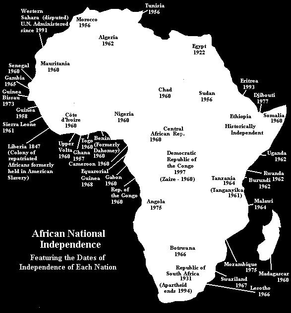
17 Colonialism in Africa European Colonial Rulers Exploited Resources Manipulated ethnic groups to fight against each other. Sent missionaries that changed the culture Set colonial borders based on European claims for territory and not on tribal lands. Video
18
19 Problems after Independence Borders were based on European colonies and not on tribal lands. Created many conflicts that still exist today Genocide in Rwanda Food shortages Health Aids Oppressive Governments Financing problems with economic development Had to borrow from western governments Quickly went in debt

20 Key Issue 2: Why do Boundaries Cause Problems? Types of boundaries Physical boundaries Cultural boundaries Shapes of states Five basic shapes Landlocked states Boundaries inside states Unitary and federal states Trend toward federal government Electoral geography

21 What is a boundary? Boundary Invisible line that marks the extent of a state s territory. Borders

22 Problems Boundaries Lack of knowledge of underground resources when boundaries were created 1990 Kuwait vs. Iraq: Rumaylah oil reserves created International conflict
23 Who Controls Airspace? When boundaries were created there was a lack of knowledge of importance of airspace a. airline traffic b. satellite space?
")
24 How are Boundaries Created? Defined usually legally by someone who is not directly involved (written) Delimitation mapped Demarcation marked with posts, walls, fences, etc.


25 Types of Boundaries: physical Important physical features on Earth s surface can make good boundaries because they are easily seen, both on a map and on the ground. Three types of physical elements serve as boundaries between states: mountains deserts water

26 Mountain Boundaries Mountains can be effective boundaries if they are difficult to cross (and) because they are rather permanent and usually are sparsely inhabited. Mountains do not always provide for the amicable separation of neighbors. Argentina and Chile agreed to be divided by the crest of the Andes Mountains but could not decide on the precise location of the crest.

27 Desert Boundaries Like mountains, deserts are hard to cross and sparsely inhabited. Desert boundaries are common in Africa and Asia.


28 Water Boundaries Rivers, lakes, and oceans Water boundaries are especially common in East Africa. Boundaries are typically in the middle of the water, although the boundary between Malawi and Tanzania follows the north shore of Lake Malawi (Lake Nyasa). Again, the boundaries result from nineteenth-century colonial practices: Malawi was a British colony, whereas Tanzania was German. Water boundaries offer good protection against attack

29 Coastal Waters The use of water as boundaries between states can cause difficulties. One problem is that the precise position of the water may change over time. Rivers, in particular, can slowly change their course. Ocean boundaries also cause problems because states generally claim that the boundary lies not at the coastline but out at sea. Law of the Sea 12 miles The reasons are for defense and for control of valuable fishing industries.

30 Frontiers in the Arabian Peninsula Frontier A zone separating two states in which neither state exercises political control. Several states in the Arabian Peninsula are separated by frontiers rather than precise boundaries.
31 Types of Boundaries: Geometric Geometric boundary: straight line boundary totally unrelated to physical features e.g. United States border with Canada or fight
32 Types of Boundaries: Cultural Antecedent boundary: some boundaries were defined and delimited before humans settled Anglo-Dutch Treaty of 1891 dividing Malaysia & Indonesia Subsequent boundaries: boundaries which developed according to the cultural landscape e.g. Vietnam/ China
33 Types of Boundaries: Cultural Superimposed boundaries: Forcibly drawn boundaries across a culturally unified landscape Papau New Guinea/ Indonesia Africa - Colonialism Relict boundary: border that has ceased to function imprints still evident in cultural landscape. N-S Vietnam

34 Language Boundaries Language is an important cultural characteristic for drawing boundaries, especially in Europe. The French language was a major element in the development of France. Italy and Germany also emerged as states that unified the speakers of particular languages. The movement to identify nationalities on the basis of language spread throughout Europe in the twentieth century.

35 Boundary Disputes Territorial / Definitional Whose Land is it? Focus on legal language of the agreement Cyprus Green Line Positional / Locational1991 Focus on delimitation and demarcation of the border The interpretation of the definition is the dispute Saudi Arabia vs. Yemen (oil rich border not covered in the treaty)

36 Division of Cyprus Fig. 8-10: Cyprus has been divided into Green and Turkish portions since 1974.

37 Boundary Disputes Functional / Operational Border Dispute way boundary should function how should each side handle cross-border migration

38 Boundary Disputes Allocational Border Dispute Dispute over boundary due to location of resources Water supplies - Colorado River /watch?v=fipv-h9icpa nasa
39 Territory Size-micro vs macro Does Size = Power? No Greater land area may equal greater resources Could also lead to problems with regulating area (communication and transportation) CIA Factbook. onlin Vatican Map Micro State - Vatican Map
 United States Land Area: 3,787.")
40 Size is not necessarily an indicator for success Russia Land Area: 6,550.7 square miles Purchasing Power Parity $9700 (2002) United States Land Area: 3,787.4 Purchasing Power Parity $36,300 (2002) CIA Factbook. online
41 Big Theme Territory size & shape can influence political stability, but can not determine social, political, or economic well being.

42 Shape of States

43 Compact State: (circle shape) the distance from any point of the country to its center is about the same. supposed to provide the most geographic stability e.g. Poland, Iceland, Democratic Republic of the Congo, Zimbabwe

44 Fragmented State consisting of 2 or more pieces can make some interactions within the country more difficult e.g. Philippines

45 Elongated Hello down there! State with a long narrow shape. Can create separatist areas due to distance from center or core Vietnam, Chile, Norway

46 Prorupt States An area that extends from a compact area Can create room for factions geographically Southern Thailand

47 African States Fig. 8-6: Southern, central, and eastern Africa include states that are compact, elongated, prorupted, fragmented, and perforated.


48 Perforated State broken by another country 1. exclaves: separated from the state by another state e.g. Russia Baarle-Hertog Point Roberts 2. enclaves: surrounded by another state b. e.g. South Africa- Lesotho

49 Landlocked States Lesotho is unique in being completely surrounded by only one state, but it shares an important feature with several other states in southern Africa, as well as in other regions: It is landlocked. The prevalence of landlocked states in Africa is a remnant of the colonial era, when Britain and France controlled extensive regions. Direct access to an ocean is critical to states because it facilitates international trade. To send and receive goods by sea, a landlocked state must arrange to use another country s seaport.

50 Boundaries inside States Within countries, local government boundaries are sometimes drawn to separate different nationalities or ethnicities. They are also drawn sometimes to provide advantage to a political party.


51 US Electoral Geography The boundaries separating legislative districts are redrawn periodically to ensure that each district has approximately the same population. European countries entrust the job to independent commissions. In most U.S. states the job is entrusted to the state legislature. Gerrymandering Process of redrawing legislative boundaries for the purpose of benefiting the party in power.

52 Types of Gerrymandering Gerrymandering takes three forms. Wasted vote spreads opposition supporters across many districts but in the minority. Excess vote concentrates opposition supporters into a few districts. Stacked vote links distant areas of like-minded voters through oddly shaped boundaries.


53 Unitary and Federal States Unitary state An internal organization of a state that places most power in the hands of central government officials. France Federal state An internal organization of a state that allocates most powers to units of local governments. United States, Poland

54 Key Issue 3: Why do states cooperate with each other? Political and Military Cooperation UN Military Economic Cooperation EU NAFTA

55 Heartland Theory Definition - In 1904, Sir Halford Mackinder published the Heartland theory. The theory proposed that whoever controls Eastern Europe controls the Heartland. It also supported the concept of world dominance. Explanation Whoever controls the heartland, controls the world island. Whoever controls the World Island, will soon rule the world. The heartland has primarily been Central Asia, the high seas, and Eurasia. Example The Theory was accepted by the The Nazi party during World War II and the Soviet Union during the Cold War.

56 The Rimland Theory Definition - In 1942, Nicholas Spykman created a theory which countered Mackinder s Heartland theory. Theory Stated that Eurasia s rimland, the coastal areas, is the key to controlling the World Island. Explanation - The rimland contains the Heartland. Whoever would control the rimland, would eventually control the World Island. Whoever would control the World Island would soon control the world. Example - His theory was influential mainly during the Cold War. The Soviet Union desired to control the rimland around them. If accomplished, the Soviet Union would control the heartland, rimland, and the World Island.

57 United Nations Members Fig. 8-1: The UN has increased from 51 members in 1945 to 191 in 2003.


58 United Nations The UN has 192 member states Goals and Purposes Maintain international peace and security Develop friendly relations among nations Achieve international cooperation in solving international problems of an economic, social, cultural, or humanitarian character

59 Economic Cooperation EU European Union Established in 1958 w/ 6 countries Now has 28 countries Currency Euro Flag Official Motto United in Diversity

60 Key Issue 4: Why has terrorism increased? Terrorism by Individual Organizations State Support for Terrorism

61 Political Geography Chapter 8 The End
Chapter 8. Political Geography
 Chapter 8 Political Geography Nations of the World Today human geographers emphasize a thematic approach, concerned with the location of activities in the world, the reasons for particular spatial distributions,
Some Very Helpful Boundary and Border Definitions
 Some Very Helpful Boundary and Border Definitions Key Terms and Definitions: Boundary - something that indicates bounds or limits. Boundary Delimitation - political boundaries on Earth's surface are determined
Nation: geographic area that is dominated by a large population that shares a common history and culture, ie. Kurds and Palestinians.
 Nation: geographic area that is dominated by a large population that shares a common history and culture, ie. Kurds and Palestinians. State: sovereign (implies a state's lawful control over it's territory
UNIT 4: POLITICAL ORGANIZATION OF SPACE
 UNIT 4: POLITICAL ORGANIZATION OF SPACE Advanced Placement Human Geography Session 1 ADVANCED PLACEMENT HUMAN GEOGRAPHY REVIEW SESSIONS: UNIT FOUR By Geri Flanary To accompany AP Human Geography: A Study
Geographical Characteristics of the State. The Cultural Mosaic Fellman, and Notes from D.J. Zeigler of Old Dominion
 Geographical Characteristics of the State The Cultural Mosaic Fellman, and Notes from D.J. Zeigler of Old Dominion Vocab Review State Sovereignty Nation Nation-state Binational or Multinational Stateless
The study of Geography and the use of geographic tools help us view the world in new ways.
 S How does Geography help us understand our world? What factors shape the Earth s different environments? 7.1.9 7.2.9 BIG IDEAS COMPETENCIES Text pages or The study of Geography and the use of geographic
Boundaries and Borders
 Political Geography Origins: Antecedent Boundaries and Borders Existed in prehistoric times Usually align with physical boundaries Pyrenees between France/Spain Cultural linguistic borders between Germanic
Key Issue #1. Where are states located?
 Political Geography Key Issue #1 Where are states located? Current World States State and Nation Terminology A nation is a group of people with a common ancestral heritage based on belief systems, customs,
Central Valley School District Social Studies Curriculum Map Grade 7. August - September
 August - September Geographical/Historical Skills Identify and analyze timelines. Construct and use cause and effect charts. Differentiate between fact and opinion. Use of word webs, flip charts, outlines
By Geri Flanary To accompany AP Human Geography: A Study Guide 3 rd edition By Ethel Wood
 Session 1 By Geri Flanary To accompany AP Human Geography: A Study Guide 3 rd edition By Ethel Wood WHAT IS DEMOGRAPHY? It is the scientific or statistical study of population. It comes from the Greek
The Geopolitics of Culture 2
 Exercise 3 Complexity of Cultural Areas (cultural interaction) Select two time periods from the list and discuss the cultural interaction that took place during each period. GRADE DISTRIBUTION 9 = A 3
Blooms: Knowledge Learning Objective: Understand how states and nations are organized.
 Human Geography, 11 th edition Practice Questions Chapter 08 1. Geographers define as the study of the political organization of the world. A. the United Nations B. political science C. political economy
September 14, 2013 Objective: How does geography impact history? What important features exist that have shaped societies?
 Lowenhaupt 1 September 14, 2013 Objective: How does geography impact history? What important features exist that have shaped societies? Warm-Up: In your binder, answer the following question: Imagine you
Iceland and the Arctic: The Politics of Territoriality. Valur Ingimundaron Professor of Contemporary History, University of Iceland
 Iceland and the Arctic: The Politics of Territoriality Valur Ingimundaron Professor of Contemporary History, University of Iceland Drivers of Icelandic Arctic Policies Geostrategic Position Economic Interests
Alleghany County Schools Curriculum Guide GRADE/COURSE: World Geography
 GRADE/COURSE: World 2013-14 GRADING PERIOD: 1 st Six Weeks Time Frame Unit/SOLs SOL # Strand Resource Assessment 8 days* The student will use maps, globes, satellite images, photographs, or diagrams to
LEARNING OUTCOMES SST (G1-G12)
") LEARNING OUTCOMES SST (G1-G12) Grade 1 Learning Outcomes Students will be expected to: - demonstrate an understanding of the importance of interactions between people - demonstrate an understanding of
LEARNING OUTCOMES SST (G1-G12) Grade 1 Learning Outcomes Students will be expected to: - demonstrate an understanding of the importance of interactions between people - demonstrate an understanding of
Unit 1 Test - Version A
 Unit 1 Test - Version A 1. Approximately, how many degrees of longitude equal one time zone change? a. 5 b. 10 c. 15 d. 20 e. 25 2. The city of Lewisville has a population of 1,000 people living in 100
TEKS: 1A, 2A, 6B, 9A, 13A, 18A
 SOCIAL STUDIES World Geography Curriculum Based Assessment (CBA) #5 TEKS: 1A, 2A, 6B, 9A, 13A, 18A World Geography, CBA 5, 5th Six Weeks WG 1.A Analyze the effects of physical and human geographic patterns
MARS AREA SCHOOL DISTRICT CURRICULUM GRADE: Grade 4
 MARS AREA SCHOOL DISTRICT CURRICULUM GRADE: Grade 4 Course Title: Social Studies Brief Description Overview: Students will explore the history, geography, government, and economy of the United States with
National Council for Geographic Education Curriculum & Instruction Committee Geography Club Submitted by: Steve Pierce
 National Council for Geographic Education Curriculum & Instruction Committee Geography Club Submitted by: Steve Pierce stevepierce@charter.net Ninth Month Activities Geography for Life: National Geography
Explain the impact of location, climate, natural resources, and population distribution on Europe. a. Compare how the location, climate, and natural
 SS6G10 Explain the impact of location, climate, natural resources, and population distribution on Europe. a. Compare how the location, climate, and natural resources of Germany, the United Kingdom and
NATIONAL RESEARCH UNIVERSITY HIGHER SCHOOL OF ECONOMICS POLITICAL GEOGRAPHY
 NATIONAL RESEARCH UNIVERSITY HIGHER SCHOOL OF ECONOMICS POLITICAL GEOGRAPHY Course syllabus HSE and UoL Parallel-degree Programme International Relations Lecturer and Class Teacher: Dr. Andrei Skriba Course
Prentice Hall. World Explorer: People, Places, Cultures Grade 7. Oklahoma Priority Academic Student Skills (PASS) for Grade 7 World Geography
 for Grade 7 World Geography") Prentice Hall World Explorer: People, Places, Cultures 2007 Grade 7 C O R R E L A T E D T O for Grade 7 1. Locate, gather, analyze, and apply information from primary and secondary sources. WORLD GEOGRAPHY
Prentice Hall World Explorer: People, Places, Cultures 2007 Grade 7 C O R R E L A T E D T O for Grade 7 1. Locate, gather, analyze, and apply information from primary and secondary sources. WORLD GEOGRAPHY
READY TO SCRAP: HOW MANY VESSELS AT DEMOLITION VALUE?
 READY TO SCRAP: HOW MANY VESSELS AT DEMOLITION VALUE? August 206 VesselsValue Global number of vessels at demolition value At scrap value 7,27 6 Above scrap value,8 84 Number of vessels at demolition value
About the Authors Geography and Tourism: The Attraction of Place p. 1 The Elements of Geography p. 2 Themes of Geography p. 4 Location: The Where of
 Preface p. ix About the Authors p. xi Geography and Tourism: The Attraction of Place p. 1 The Elements of Geography p. 2 Themes of Geography p. 4 Location: The Where of Geography p. 4 Place and Space:
Human Geography: Places and Regions in Global Context Sixth Edition. Political Geographies. Chapter 9 Lecture
 Chapter 9 Lecture Human Geography: Places and Regions in Global Context Sixth Edition Political Geographies Wendy A. Mitteager State University of New York, Oneonta Key Concepts Geopolitics Territories
Wednesday, May 23, 2018
 Wednesday, May 23, 2018 Physical Geography of West Africa Objective: Summarize the main geographic aspects of each country in West Africa. Understand each country s development pattern and their current
DOWNLOAD OR READ : NATIONS OF EUROPE FUN FACTS ABOUT EUROPE FOR KIDS PDF EBOOK EPUB MOBI
 DOWNLOAD OR READ : NATIONS OF EUROPE FUN FACTS ABOUT EUROPE FOR KIDS PDF EBOOK EPUB MOBI Page 1 Page 2 nations of europe fun facts about europe for kids nations of europe fun pdf nations of europe fun
International Student Enrollment Fall 2018 By CIP Code, Country of Citizenship, and Education Level Harpur College of Arts and Sciences
 International Student Enrollment Fall 2018 By CIP Code, Country of Citizenship, and Education Level Harpur College of Arts and Sciences CIP Code Description Citizenship Graduate Undergrad Total 00.0000
Proposed AKS for 6 th Grade Social Studies
 Proposed AKS for 6 th Grade Social Studies A. Map and Globe Skills 1. use cardinal directions 2. use intermediate directions 3. use a letter/number grid system to determine location 4. compare and contrast
Sixth Grade Social Studies. QPA Schedule
 2017 2018 Sixth Grade Social Studies Unit 1: Concepts Used in Global Studies 5 Weeks Unit 2: History & Geography of Europe 5 Weeks Unit 3: Europe Today 6 Weeks Unit 4: History & Geography of Latin America
LOUISIANA STUDENT STANDARDS FOR SOCIAL STUDIES THAT CORRELATE WITH A FIELD TRIP TO DESTREHAN PLANTATION KINDERGARTEN
 LOUISIANA STUDENT STANDARDS FOR SOCIAL STUDIES THAT CORRELATE WITH A FIELD TRIP TO DESTREHAN PLANTATION KINDERGARTEN Standard 2 Historical Thinking Skills Students distinguish between events, people, and
Chapter 12: Pacific Realm and Polar Futures
 Geography: Realms, Regions and Concepts 15 th Edition By de Blij and Muller Chapter 12: Pacific Realm and Polar Futures Defining the Realm Sea Hemisphere: seas covering nearly an entire hemisphere Fragmented,
AP Human Geography AP EXAM Free Response Questions and Possible Future Questions
 AP Human Geography AP EXAM Free Response Questions and Possible Future Questions FRQ Exam Questions: Population & Migration 2003- European Migration and Demographic Transition Model 2004- Population Pyramids
MINORITY CULTURES IN CATALAN CULTURE
 MINORITY CULTURES IN SPAIN. CATALONIA AND THE CATALAN CULTURE Dr. Joan Tort Oulun Yliopisto, Suomi/Finland 24th April, 2008 Key words: Catalonia/Spain/Europe Old Europe Territorial i identities Managing
Your web browser (Safari 7) is out of date. For more security, comfort and the best experience on this site: Update your browser Ignore
 is out of date. For more security, comfort and the best experience on this site: Update your browser Ignore") Your web browser (Safari 7) is out of date. For more security, comfort and the best experience on this site: Update your browser Ignore Activitydevelop RESEARCH EXAMPL ES O F PHYSICAL GEO GRAPHY How do
Your web browser (Safari 7) is out of date. For more security, comfort and the best experience on this site: Update your browser Ignore Activitydevelop RESEARCH EXAMPL ES O F PHYSICAL GEO GRAPHY How do
Social Studies Continuum
 Historical Skills chronological thinking understand that we can learn about the past from different sorts of evidence begin to use historical resources apply research skills by investigating a topic in
Your web browser (Safari 7) is out of date. For more security, comfort and the best experience on this site: Update your browser Ignore
 is out of date. For more security, comfort and the best experience on this site: Update your browser Ignore") Your web browser (Safari 7) is out of date. For more security, comfort and the best experience on this site: Update your browser Ignore ISTHMU S tombolo For the complete encyclopedic entry with media resources,
Your web browser (Safari 7) is out of date. For more security, comfort and the best experience on this site: Update your browser Ignore ISTHMU S tombolo For the complete encyclopedic entry with media resources,
History and Social Science: Advanced Placement Human Geography
 History and Social Science: Advanced Placement Human Geography A.P. Human Geography Curriculum for Loudoun County Public Schools Ashburn, Virginia 2016 This curriculum document for Advanced Placement Human
The Indian Ocean. Copyright 2010 LessonSnips
 The Indian Ocean One of the five major geographic divisions of the world s ocean, the Indian Ocean is located in the Eastern Hemisphere. The Indian Ocean is bounded by three continents: Africa to the west,
Slide 1 Geography: Realms, Regions, and Concepts 15 th Edition. Slide 2. Slide 3 Defining the Realm. Chapter 12: Pacific Realm and Polar Futures
 Slide 1 Geography: Realms, Regions, and Concepts 15 th Edition Chapter 12: Pacific Realm and Polar Futures Slide 2 Slide 3 Defining the Realm Sea Hemisphere: seas cover nearly an entire hemisphere: Fragmented,
23TGEO 220 COURSE OUTLINE. Prerequisites: None. Course Description:
 Lecture 23TGEO 220 23TWorld Regional Geography Revised: Fall 2015 COURSE OUTLINE Prerequisites: None Course Description: Studies physical and cultural characteristics of selected geographical regions of
The Geopolitics of 2017 in 4 Maps
 The Geopolitics of 2017 in 4 Maps Jan. 23, 2017 We showcase some of the maps that visually represent the year ahead best. Originally produced on Jan. 16, 2017 for Mauldin Economics, LLC George Friedman
Name three countries in Europe.
 Name three countries in Europe. I will be able to identify the 5 themes of geography for Europe and locate the countries and capitals of Europe and the major physical features. People: Past: Through the
The map document opens, and you see a physical map of the world with the Saudi Arabian Peninsula outlined in red.
 Module 5, Lesson 2 A line in the sand The ever-changing map of the world reflects the forces of conflict and cooperation among nations and peoples of the world. In this activity, you will explore one of
AP Human Geography Summer Homework 2016 JW Mitchell High School Mrs. Daniel
 AP Human Geography Summer Homework 2016 JW Mitchell High School Mrs. Daniel hdaniel@pasco.k12.fl.us Welcome to A.P. Human Geography. I am excited that you decided to take this journey to learn more about
World Industrial Regions
 World Industrial Regions North America Industrialized areas in North America Changing distribution of U.S. manufacturing Europe Western Europe Eastern Europe East Asia Manufacturing Regions Fig. 11-3:
Chapter 14. Representative Table and Composite Regions. Betina V. Dimaranan Representative Table
 Chapter 14 Representative Table and Composite Regions Betina V. Dimaranan This chapter describes the representative input-output table and the construction of input-output tables for the composite regions
Corporate Governance, and the Returns on Investment
 Corporate Governance, and the Returns on Investment Klaus Gugler, Dennis C. Mueller and B. Burcin Yurtoglu University of Vienna, Department of Economics BWZ, Bruennerstr. 72, A-1210, Vienna 1 Considerable
Prentice Hall World Cultures: A Global Mosaic 2004 Correlated to: Wisconsin Model Academic Standards for Social Studies (By the end of Grade 12)
") Wisconsin Model Academic Standards for Social Studies (By the end of Grade 12) A. Geography: People, Places, and Environments A.12.1 Use various types of atlases and appropriate vocabulary to describe
Wisconsin Model Academic Standards for Social Studies (By the end of Grade 12) A. Geography: People, Places, and Environments A.12.1 Use various types of atlases and appropriate vocabulary to describe
World Geography Fall 2013 Semester Review Project
 Reporting Category RC 1: History, Government and Citizenship Standard WG.1 History. The student understands how geography and processes of spatial exchange (diffusion) influenced events in the past and
Students will able to: Define Geography Explain the 5 Themes Analyze the 5 Themes with an example
 What is Geography? Students will able to: Define Geography Explain the 5 Themes Analyze the 5 Themes with an example What is Geography Geography is about spatial thinking The questions we want to ask What
2017 Source of Foreign Income Earned By Fund
 2017 Source of Foreign Income Earned By Fund Putnam Emerging Markets Equity Fund EIN: 26-2670607 FYE: 08/31/2017 Statement Pursuant to 1.853-4: The fund is hereby electing to apply code section 853 for
Chapter 9: Looking Beyond Poverty: The Development Continuum
 Chapter 9: Looking Beyond Poverty: The Development Continuum Using measures such as Gross Domestic Product (GDP), Gross National Income (GNI), and more recently the Human Development Index (HDI), various
Nigerian Capital Importation QUARTER THREE 2016
 Nigerian Capital Importation QUARTER THREE 2016 _ November 2016 Capital Importation Data The data on Capital Importation used in this report was obtained from the Central Bank of Nigeria (CBN). The data
Globes, Maps, and Atlases. Plus, A Whole Bunch of Other Way Cool Geographic Information!!!
 Globes, Maps, and Atlases Plus, A Whole Bunch of Other Way Cool Geographic Information!!! Globes Are the Most Accurate Portrayal of the Earth The earth is about 24,900 miles in circumference, and about
Social Studies Curriculum Sixth Grade
 Social Studies Curriculum Sixth Grade A. History Students will examine the key historic movements, events, and figures that contributed to the development of modern Europe and American nations from early
Stillwater Area Schools Curriculum Guide for Elementary Social Studies
 Stillwater Area Schools Curriculum Guide for Elementary Social Studies Grade Four Draft March 21, 2006 Minnesota and the St. Croix Valley I. Historical Skills A. The student will acquire skills of chronological
Subunit 4.1: 2.5 hours. Subunit 4.2: 2.75 hours. Subunit 4.3: 1.5 hours. Subunit 4.4: 3.5 hours. Subunit 4.5: 1.5 hours Unit 4 Learning Outcomes close
 Unit 4: North America The realm of North America extends from the polar regions of the Arctic in northern Canada and Alaska, all the way south through Mexico and the countries of Central America. Geographers
Your web browser (Safari 7) is out of date. For more security, comfort and. the best experience on this site: Update your browser Ignore
 is out of date. For more security, comfort and. the best experience on this site: Update your browser Ignore") Your web browser (Safari 7) is out of date. For more security, comfort and lesson the best experience on this site: Update your browser Ignore Political Borders Why are the borders of countries located
Your web browser (Safari 7) is out of date. For more security, comfort and lesson the best experience on this site: Update your browser Ignore Political Borders Why are the borders of countries located
Social Studies Framework K-12 ( ) 1
 1") RIVERVIEW SCHOOL DISTRICT NO. 407 STRAND CIVICS (GOVERNMENT) ECONOMICS HISTORY GEOGRAPHY Grade K Me & My Community Working together Purpose of rules Being a community contributor Compare/contrast needs
RIVERVIEW SCHOOL DISTRICT NO. 407 STRAND CIVICS (GOVERNMENT) ECONOMICS HISTORY GEOGRAPHY Grade K Me & My Community Working together Purpose of rules Being a community contributor Compare/contrast needs
Sam Bateman and. State Practice Regarding Straight Baselines In East Asia Legal, Technical and Political Issues in a
 State Practice Regarding Straight Baselines In East Asia Legal, Technical and Political Issues in a Changing Environment Sam Bateman and Clive Schofield The Australian National Centre for Ocean Resources
Supplementary Appendix for. Version: February 3, 2014
 Supplementary Appendix for When Do Governments Resort to Election Violence? Version: February 3, 2014 This appendix provides supplementary information not included in the published draft. Supplementary
TRIBUNE MODEL SCHOOL Syllabus for Session Subject: Social Science CLASS IV
 TRIBUNE MODEL SCHOOL Syllabus for Session 2017-18 Subject: Social Science CLASS IV Text Books 1. Candid New Trends in Social Science 4 2. Candid New Trends in Social Science (Worksheets) 4 Term I (Chapters
On Earth, the land is broken into large pieces. These pieces are separated by large bodies of water called oceans. We call some of these pieces of
 The 7 Continents On Earth, the land is broken into large pieces. These pieces are separated by large bodies of water called oceans. We call some of these pieces of land continents. A continent is an area
Edgebrook Geography Bee Workshop
 Edgebrook Geography Bee Workshop January 12, 2015 1/13/2015 1 Image from https://www.google.com/search?q=world+map 1/13/2015 2 Two Bees Grade 4-8: National Geographic Society (NGS) Geography Bee School
Item Specifications Summary 7 th grade World Geography Assessment
 Item Specifications Summary 7 th grade World Geography Assessment 2013-14 Structure: 65 multiple choice questions (15 field test items) Minimum of 6 questions per standard At least 75% of objectives have
Forecast Million Lbs. % Change 1. Carryin August 1, ,677, ,001, % 45.0
 Almond Industry Position Report DECEMBER 2017 2017-2018 Crop Year Salable Forecast Million Lbs. 2017-2018 08/01-12/31 Kernel Wt. 2016-2017 08/01-12/31 Kernel Wt. % Change 1. Carryin August 1, 2017 398.7
21st Century Global Learning
 21st Century Global Learning A focus for 7th grade is on the ever-increasing global interactions in society. This focus includes a study of various societies and regions from every continent. We have already
HPISD CURRICULUM (SOCIAL STUDIES, WORLD GEOGRAPHY)
") HPISD CURRICULUM (SOCIAL STUDIES, WORLD GEOGRAPHY) EST. NUMBER OF DAYS: 14 UNIT NAME Unit Overview UNIT 7 SOUTH WEST ASIA/NORTH AFRICA SWANA s geography has led to economic and cultural differences. Students
HPISD CURRICULUM (SOCIAL STUDIES, WORLD GEOGRAPHY) EST. NUMBER OF DAYS: 14 UNIT NAME Unit Overview UNIT 7 SOUTH WEST ASIA/NORTH AFRICA SWANA s geography has led to economic and cultural differences. Students
Tuesday, December 5, 2017
 Tuesday, December 5, 2017 Southern Europe Physical Geography Content Objective: WG.4A Explain how elevation, latitude, wind systems, ocean currents, position on a continent, and mountain barriers influence
5 th Grade Social Studies Goals for the First Trimester Miss Gaull
 5 th Grade Social Studies Goals for the First Trimester Overview: American People, American Land The American People Government by the People Free Enterprise Lands and Regions Resources and the Environment
Third Annual Climate Science and Policy Conference, UC Santa Cruz: Earth s Climate Future: Unchartered Territory
 Third Annual Climate Science and Policy Conference, UC Santa Cruz: Earth s Climate Future: Unchartered Territory Geopolitics of Climate Change: The Arctic Case Steven L. Lamy, PhD Vice Dean for Academic
2,152,283. Japan 6,350,859 32,301 6,383,160 58,239, ,790 58,464,425 6,091, ,091,085 52,565, ,420 52,768,905
 Almond Industry Position Report APRIL 2018 2017-2018 Crop Year Salable Forecast Million Lbs. 2017-2018 08/01-04/30 Kernel Wt. 2016-2017 08/01-04/30 Kernel Wt. % Change 1. Carryin August 1, 2017 398.7 398,677,112
A Cold War Map and Image Gallery
 A Cold War Map and Image Gallery Visualizing Global Geopolitics Presented by The California Geographic Alliance and The San Diego State University Geography Department This handout provides information
Reshaping Economic Geography
 Reshaping Economic Geography Three Special Places Tokyo the biggest city in the world 35 million out of 120 million Japanese, packed into 4 percent of Japan s land area USA the most mobile country More
January 2018 Special Preview Edition
 January 2018 Special Preview Edition What s inside this booklet? The contents you ll explore 2 Americas 4 Europe 6 Far East & Oceania 8 Central & South Asia 10 Africa & Middle East 12 International 14
a division of Teacher Created Materials
 Sample Pages from a division of Teacher Created Materials Thanks for checking us out. Please call us at 877-777-3450 with questions or feedback, or to order this product. You can also order this product
Amarillo ISD Social Studies Curriculum
 Amarillo Independent School District follows the Texas Essential Knowledge and Skills (TEKS). All of AISD curriculum and documents and resources are aligned to the TEKS. The State of Texas State Board
Forecast Million Lbs. % Change 1. Carryin August 1, ,677, ,001, % 45.0
 Almond Industry Position Report NOVEMBER 2017 2017-2018 Crop Year Salable Forecast Million Lbs. 2017-2018 08/01-11/30 Kernel Wt. 2016-2017 08/01-11/30 Kernel Wt. % Change 1. Carryin August 1, 2017 398.7
ia PU BLi s g C o M Pa K T Wa i n CD-1576
 M h M y CD-1576 o M Pa g C n ar ia PU BLi s in K T Wa i n ed National Geography Standards National Geography Standards Teachers leading discussions while completing units and activities is a prerequisite
World Geography Unit 14 Suggested Dates Australia and the Pacific Realm 1 week 6 th 6 weeks. in the Pacific Realm?
 World Geography Unit 14 Title Suggested Dates Australia and the Pacific Realm 1 week 6 th 6 weeks Big Idea/Enduring Understanding The components of culture affect the way people live and shape the characteristics
CURRICULUM COURSE OUTLINE
 CURRICULUM COURSE OUTLINE Course Name(s): World Area Studies Grade(s): 9-11 Department: Social Studies Course Length: 1 Semester Pre-requisite: None Textbook/Key Resource: No Primary Textbook Course Description:
Important Developments in International Coke Markets
 Important Developments in International Coke Markets Andrew Jones Resource-Net South Africa China Coke Market Congress Xuzhou, Jiangsu September 2018 Introduction to Presentation Resource-Net produces
Major Domain of the Earth
 Major Domain of the Earth The surface of the earth is a complex zone in which three main components of the environment meet, overlap and interact. The solid portion of the earth on which we live is called
ANTARCTICA. Boštjan Kop 8.a Lovrenc na Pohorju, May 2004
 ANTARCTICA Boštjan Kop 8.a Lovrenc na Pohorju, May 2004 HISTORY Though writings of the ancient Greeks cryptically refer to a massive southern region of the world, the discovery of the "White Continent"
SOCIAL SCIENCES. WORLD GEOGRAPHY LH Grade(s): 9 Pre-Req: N/A
: 9 Pre-Req: N/A") SOCIAL SCIENCES WORLD GEOGRAPHY 21033000 Grade(s): 9 The World Cultural Geography course consists of the following content area strands: American History, World History, Geography, Humanities, Civics and
SOCIAL SCIENCES WORLD GEOGRAPHY 21033000 Grade(s): 9 The World Cultural Geography course consists of the following content area strands: American History, World History, Geography, Humanities, Civics and
Map List. 560 World World Physical World Physical-Pacific & Atlantic Region World Landforms World Ocean Floor 10
 Map List CategoryName Map# MapName Thumb nail Page # 560 World 2 561 World Physical 4 562 World Physical-Pacific & Atlantic Region 6 563 World Landforms 8 564 World Ocean Floor 10 565 North Polar Region
Unit 1 Welcome to the World
 Unit Welcome to the World There are five fields of learning in social studies. We learn about the world and its people by studying geography, history, economics, government, and culture. A Mongolian yurt,
TOPIC 8: POPULATION DISTRIBUTION AND URBANIZATION
 TOPIC 8: POPULATION DISTRIBUTION AND URBANIZATION Concept of population distribution Factors affecting population distribution and density Urbanization: Concept and issues associated Introduction WORLD
Introduction to World Regions
 Introduction to World Regions Geography has made us neighbors. History has made us friends. Economics has made us partners, and necessity has made us allies. Those whom God has so joined together, let
Chapter 1: Europe Part 1: Teacher Notes
 Chapter 1: Europe Part 1: Teacher Notes Introduction: Over the past 5 centuries Europe has influenced and changed the world more than any other realm Helped create new societies o Through imperialism &
World Geography to ALL Students book (teacher book).
.") Sample Pages are from the What I Need to Know to Successfully Teach World Geography to ALL Students book (teacher book). This book contains the content in the student book, the reformatted Standards for
Sample Pages are from the What I Need to Know to Successfully Teach World Geography to ALL Students book (teacher book). This book contains the content in the student book, the reformatted Standards for
Unit of Study: Physical Geography & Settlement Patterns; Culture & Civilizations; and The Spread of Ideas
 6 th Grade Social Studies 1 st Nine Weeks TEKS Unit of Study: Physical Geography & Settlement Patterns; Culture & Civilizations; and The Spread of Ideas 6.1) History. The student understands that historical
STAAR Vocabulary Words extracted directly from the standard and/or associated with the instruction of the content within the standard.
 STAAR Vocabulary Words extracted directly from the standard and/or associated with the instruction of the content within the standard. READINESS STANDARDS - World Geography (WG.1) History. The student
Canadian Imports of Honey
 of 0409000029 - Honey, natural, in containers of a weight > 5 kg, nes (Kilogram) Argentina 236,716 663,087 2,160,216 761,990 35.27% 202.09% /0 76,819 212,038 717,834 257,569 35.88% 205.69% /0 United States
Socorro Independent School District World Geography 3 rd 9 Weeks. Culture. Government. European Terminology
 Unit Essential Questions SE Monday Tuesday Wednesday Thursday Friday Unit 05: Latin America Unit 6: How did the major landforms of Latin America impact its developmen t? How is Latin American history a
This image cannot currently be displayed. Course Catalog. World Geography Glynlyon, Inc.
 This image cannot currently be displayed. Course Catalog World Geography 2016 Glynlyon, Inc. Table of Contents COURSE OVERVIEW... 1 UNIT 1: INTRODUCTION TO GEOGRAPHY... 1 UNIT 2: HUMAN GEOGRAPHY... 1 UNIT
CHAPTER 3 POPULATION AND CULTURE SECTION 1: THE STUDY OF HUMAN GEOGRAPHY
 CHAPTER 3 POPULATION AND CULTURE SECTION 1: THE STUDY OF HUMAN GEOGRAPHY THE STUDY OF HUMAN GEOGRAPHY Human geography includes many topics Language Religion Customs Economics Political Systems One particular
GACE Middle Grades Social Science Assessment Test at a Glance
 GACE Middle Grades Social Science Assessment Test at a Glance Updated June 2017 See the GACE Middle Grades Social Science Assessment Study Companion for practice questions and preparation resources. Assessment