T. V. CiSTUP. CST and CES, IISc, 16 th Nov 2009 Centre for Infrastructure, Sustainable Transportation and Urban Planning [CiSTUP]
|
|
|
- Darlene Wright
- 5 years ago
- Views:
Transcription


,")
1 T. V. CiSTUP. CST and CES, IISc, 16 th Nov 2009 Centre for Infrastructure, Sustainable Transportation and Urban Planning [CiSTUP] Indian Institute of Science, Bangalore, OSGEO (India), KSCST, IISc Campus
2 Discussion at CES R No 215, during June and Oct 2000 (Prasad and TVR) Dt Date: Thu, 26 Jul :30: (BST), Narendra Prasad" narendra_prasad@yahoo.com Subject: Re: From SN Prasad My dear Ramachandra, I am happy to inform you that the GRASS proposal was approved by MOEnF on 24.They have agreed to Rs 2 lacs only. You have to somehow adjust the inst. charges. Detailed MOU will be sent to you soon. Prasad
3 Date: Mon, 14 Jan :32: (GMT) From: "[iso ] Narendra Prasad" To: Dr. T.V. Ramachandra My dear Ramachandra, Thanks for the progress report. I am really sorry that you have so far not received the funds. I will find out from Coimbatore the reason and will get back to you. Pl continue the project as planned as approvals are already there for payments. There has been a major bungling as usual from the MOEn F on release of funds and I suspect that is the reason you got no response. Did you sign the MOU?. Pl Inform Thanks Prasad Dr. T.V. Ramachandra <cestvr@ces.iisc.ernet.in> wrote: > Dear Dr. Prasad This is just to keep you updated. Report is attached detailing the progress of work. I have also attached the training report. I have not heard from Dr.Vijayan so far. Please advice. with best regards tvr
4
5 Date: Fri, 30 Aug :20: (BST) From: "[iso ] Narendra Prasad" Subject: Re: Mr.Viashnav's visit to Dehradun My dear Ramachandra, If Mr Vih Vaishnav can visit ii any time in the second week. The GRASS loaded d in the laptop cannot be accessed as the user name as well as the password are refused!.i hope vaishnav can reload the linux as well as the GRASS Prasad "Dr. T.V. Ramachandra <cestvr@ces.iisc.ernet.in> wrote: > Dear Dr.Prasad Mr.Vaishnav has made significant progress in the project and has included PostGRE sql. As per our earlier discussion, i he plans to visit iit Dehradun in IInd week of September. Please confirm the dates as per your convenience. with best regards tvr
6 Date: Thu, 11 Dec :22: (GMT), From: "[iso ] Narendra Prasad" My dear Ramachandra, It was very nice that GRASS mirror site is at CES.Congratulations. I have some suggestions.i am planning to be in CES on 15 for this purpose only. Your mail came in the right time for me!!.i will reach if my morning flight from Delhi comes at right time CES by or so and will be there till afternoon. If you have any good BE/ME student in water resources to work for wetlands project(mainly hydrology aspects) and also willing to do Ph.D, pl let me know. The project is for three years and is on the UP wetlands. Congratulations once again and with best wishes Prasad "Dr. T.V. Ramachandra" cestvr@ces.iisc.ernet.in wrote: > Dear Dr.Prasad INDIAN SITE for GRASS is set up at CES We plan to place the GUI developed at CES at this site. You may also see the front page
7
8 1. Ramachandra T.V., Uttam Kumar, Vaishnav B and Prasad S.N., Geographic Resources Decision Support System an open source GIS, Geospatial Today, 3(3): Ramachandra T.V. and Uttam Kumar, Geographic resources decision support system for land use land cover dynamics analysis, FOSS/GRASS 2004 Conference, sept 2004, Bangkok, k Thailand. 3. T. V. Ramachandra, S. N. Prasad, Uttam Kumar and Vaishnav B (2005). GRASS Applications in Land use/land cover assessments. Paper presented at Workshop on Free and Open Source Software, Geological Survey of India, Southern Region, May, Hyderabad, pp2 4. Date: Wed, 19 Jan :40: (GMT) From: Narendra Prasad <narendra_prasad@yahoo.com> Subject: Re: Thanks for the Geospptial&Lake2002 My dear Ramachandra, Many thanks for the Geospatial Today featuring GRDSS. It is well written and hopefully we will get people to use it. Regards Prasad
9
10
11
12 Date: sat, 7 jan :09: (gmt) From: narendra prasad <narendra_prasad@yahoo.com> Subject: re: happy new year My dear Ramachandra, It is nice to know that t uttam has rejoined you. The GSI has been waiting for the GRDSS to be available. Is there something that you can do? I would like one of Our pc s exclusively for GRASS and therefore require The whole set up(linux and grdss). I can send santosh from Hyderabad to ces for the required hands on Experience for installing grass and linux at Hyderabad. He has some basic experience on linux. Meanwhile can you pl arrange to provide link to our Wetland website wetlandsofindia org from your ENVIS Website? Best regards Narendra prasad
13 Patents and Design Registrations PATENT /REGISTRATION 2006 Type Title of the work Registration ti Number Copy Left Geographic Resources Decision Support System SW2658/2006 Ramachandra T V, Uttam Kumar Prasad S N, Vaishnav B
14 Urban sprawl pattern recognition Aswathnarayana M.V.J. College of Engg using remote sensing Kamal G. B.E. (computers) 2002 Urban Sprawl Pattern Recognition Karthik S. Raj PES College of Engg, Mandya MCA, 2002 Land use analysis using GRASS Uttam Kumar Department tof Computer Science (Geographic Resources Analysis Support System), 2003 BE (Information Science) 2003 and Engineering, SJM Institute of Technology, Chitradurga. Landscape characterization using Shilpa, p, S. Information Science and GIS and remote sensing B.E. (Information Science), Engineering, The National, Evaluation of Algorithms for land cover analysis using Hyperspectral data, Geo-visulaisation for local resource planning a free open source approach Image Fusion Techniques in Remote Sensing-Digital Image Processing Uttam Kumar, Jaisen N.D. M Sc (2008) Bharath H Aithal BE (2009) IIRS, DEhradun and ITC Netherland School of Environmental Sciences M G University, Kerala UVCE, Bangalore University
15 1. Ramachandra T V, Mapping of Fuelwood trees using Geoinformatics, Renewable and Sustainable Energy Reviews,, In Press,, Uncorrected Proof,, Available online 4 November 2009 [doi: /j.rser ] 2. Ramachandra T V and Uttam Kumar, Land surface temperature with land cover dynamics: multi-resolution, spatio-temporal data analysis of Greater Bangalore, International Journal of Geoinformatics, 5 (3): Ramachandra T. V., and Uttam Kumar, (2009). Geoinformatics for Urbanisation and Urban Sprawl pattern analysis. Chapter 19, In: Geoinformatics for Natural Resource Management (Eds. Joshi et al.). Nova Science Publishers, NY. Pp Uttam Kumar, Mukhopadhyay C and Ramachandra T V., Spatial data mining and modelling for visualisation of rapid urbanisation, SCIT Journal, 9(2): Uttam Kumar, Chiranjit Mukhopadhyay, and T. V. Ramachandra, Pixel based fusion using IKONOS imagery, International Journal of Recent Trends in Engineering (Computer Science), 1(1): Bharath H Aithal, Uttam Kumar, Ramachandra T V, Fusion of multi resolution remote sensing data for urban sprawl analysis, COSMAR 2009, Orgnised by MS, IISc. 7. Ramachandra T.V and Uttam Kumar, Wetlands of Greater Bangalore, India: Automatic Delineation through Pattern Classifiers, The Greendisk Environmental Journal. Issue 26 (International Electronic Jour. URL: (
16 8. Uttam Kumar and Ramachandra T.V Endmembers discrimination in MODIS using spectral angle mapper and maximum likelihood algorithms, International Journal of Applied Remote Sensing, 2(1): Ramachandra, T. V. and Kumar Uttam, Decision Support System for Land Use Planning. The Icfai University Journal of Environmental Sciences, II ( 3): 7-19, Available at SSRN: Ramachandra T.V., Geospatial Mapping of Bioenergy Potential in Karnataka, India. Journal of Energy & Environment (JEE), 6(1): Ajay Narendra and Ramachandra T.V., Remote detection and distinction of ants using nest-site specific LISS-derived Normalised Difference Vegetation Index, Asian Myrmecology Volume 2, Ramachandra T.V., Vegetation Status in Uttara Kannada District, Mapana Journal of Sciences, 6(1): Ramachandra T.V., Spatial Analysis and Characterisation of Lentic Ecosystems: A Case Study of Varthur Lake, Bangalore, International ti Journal of Ecology and Environment, 9(8): Ramachandra T.V. and Uttam Kumar, Relevance of Hyperspectral Data for Sustainable Management of Natural Resources, GIS and Development 10(4):30-36 (India) 15. Ramachandra T.V. and Uttam Kumar, Watershed Management using GRDSS, GIS and Development 8(8):20-26 (India) 16. Ramachandra T.V., Uttam Kumar, Vaishnav B and Prasad S.N., Geographic Resources Decision Support System an open source GIS, Geospatial Today, 3(3): 52-59
17 Dear All, Having had the chance to meet and discuss with most of the initial India OSGeo Chapter Members in early August, 2006, I take the liberty to propose the following members to take up the role of officers of India OSGeo Chapter. a) Co Cordinator, India OSGeo Chapter (any volunteers or suggestion. We need somebody who can spend time keeping the wiki and India OSGeo Chapter Website updated) b) OSGeo Software Development Chairs (Prototyping, Localization, Proof of Concepts etc.) (Jitendra Shah, VJTI and T.V. Ramachandra, IISc. Hope both of you can agree to this) c) Regional Events Chairs (V. Ravi Kumar, GSI, Maneesh Prasad, GIS Development. Hope both of you can agree to this) d) Education and Training (K.K. Surendran and N.J. Pawar. Hope both of you can agree to this) Your comments and suggestions are welcome. Look forward for some inputs from Autodesk India too. Autodesk USA and Autodesk Asia Pacific have been greatly supporting OSGeo since its inception. Kind regards Venkatesh
18 Dear Prof. Venkatesh Ragahavan Thank you for your mail and the inclusion in OSGeo. My research group is involved actively in the development OS GIS. GRASS mirror in India is located at iisc ernet in/grass/welcome html GRDSS developed by us is at Currently we are involved in1. working on mapping urban sprawl, understading of sprawl dynamics; this involves geospatial simulations Developing algorithms for hyperspectral image processing. Optimal spectral and spatial resolutions for land use planning. I suggest you to include my colleague Mr.Uttam Kumar uttam@ces.iisc.ernet.in), who had also attended the workshop organised by you. with best regards TVR
19 ernet in; E mail: cestvr@ces.iisc.ernet.in grass@ces.iisc.ernet.in URL: Indian GRASS mirror site:
20 Linux Operating system PostgreSQL (Database Management System) TCL/TK C compiler At least 64 MB RAM for better performance is desired and around 200 MB space for compiling binaries and source code.
21 GRASS is a freeware under the GNU General Public License (GPL). GRASS consists of more than 350 programs (in C) and tools to render maps and images on monitor and manipulate raster, vector, and sites data; process multi spectral image data; and create, manage, g, and store spatial data. Works in command line arguments.
22 GRDSS is a freeware under the GNU General Public License (GPL). GRDSS consists it of more than 350 programs (in C) and tools to render maps and images on monitor manipulate raster, vector, and sites data create, manage, and store spatial il data GRDSS works through it's... LOCATION/MAPSET concept. A "LOCATION" is some geographic extent that contains data sets in the same coordinate system. MAPSET can organize GIS maps thematically or geographically or by project or whatever. Technically they are subdirectories under any location.
23 data management image processing graphics production spatial modelling visualization of many types of data help policy makers and planners to take effective decision
24 GRDSS design and conceptual diagram.
25 GRDSS data flow diagram.
26 GRDSS hierarchical menu.
27 GRDSS is a user friendly GUI (Graphical User Interface) in Tcl/Tk based on GRASS, developed in Linux. Extraction module of LISS 3 bands from IRS (Indian Remote Sensing Satellites) in BIL (Band Interleaved by lines) format. GUI more aesthetically ti appealing. GRASS commands (functions) now categorized and arranged in hierarchical order in the GUI. GUI developed keeping in view the novice users, less experienced in working with GRASS commands.
28
29


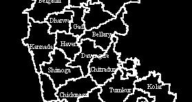

30 INDIA Kolar district Karnataka state Taluks
31 IRS 1C and 1D PATH AND ROWS for Kolar District Paths Rows 63 64
32 Normalized LAND COVER Difference ANALYSIS Vegetation Index N
33 Vegetation Indices with area under vegetation and non-vegetation Vegetation Indices Cutoff point Area in hectares (ha) Area in percentage (%) Non-vegetation Vegetation Non-vegetation Vegetation RATIO NDVI RVI NRVI TVI CTVI TTVI PVI PVI PVI PVI DVI AVI SAVI TSAVI TSAVI MSAVI MSAVI WDVI
34 Fusion of LISS3 imagery with spatial resolution 23.5 meters and PAN with spatial resolution 5.8 meters data using RGB (Red, Green, Blue) to HIS (Hue, Intensity, Saturation) and HIS to RGB conversion technique. Generation of FCC (False Color Composite) and identification of training sites on FCC. Collection of attribute information from field corresponding to the chosen training sites using GPS. Classification of remote sensing data (1998 and 2002): Land use analyses (both district wise and taluk wise) with overall accuracy of 78.08%. Change detection analysis using different techniques (Image differencing, Image ratioing, etc.). Detection, visualisation and assessment of change analysis. Statistical analysis and report generation.
35 Water Kolar district with training data sets Built up Agriculture Forest N Plantation Waste land


36 Landuse classification of Kolar district Year 1998 Year 2002 N N Built up Built up
37 Landuse details of Kolar district Categories Area (in ha) Area (%) Area (in ha) Area (%) Agriculture Built up Forest Plantation Waste land Categories Non vegetation Vegetation


38 N Water bodies Drainage Network
39 N


40

41
42 Survey of India (SOI) toposheets of 1:50000 and 1: Field data were collected with a handheld GPS. Landsat MSS of 1973 Landsat TM of 1992 Landsat ETM+ of 2000 IRS LISS III of 1999 and 2006 MODIS (Moderate Resolution Imaging Spectroradiometer) t Surface Reflectance 7 bands product of 2000 and 2007 MODIS Land Surface Temperature/Emissivity 8 Day L3 Global and Daily L3 Global (V004 and V005 products) SRTM (Shuttle Radar Topography Mission) elevation data of 90 m resolution Google Earth data ( served in pre and post classification process and validation of the results.
43
44 Concentrated activities leading to intense urbanisation Rapid urbanisation leading to sprawl Urban Sprawl? Outgrowth of cities either along the periphery or along the highway. Increase in the spatial extent of the city. * lack of basic amenities (water, electricity, sewage, solid waste management, etc.) Built forms / built up areas as a direct measure of sprawl the proportional change
45 Loss of waterbodies Lack of appropriate infrastructure (social and economic) Changes in local climate Increased population Traffic bottlenecks Enhanced pollution levels l Lack of Governance
46 Class Year Built up Vegetation Water Bodies Others 1973 Ha % Ha % Ha % Ha % Ha % Ha % Ha % Land use (%) Year r) Water bodies (number Vegetation Others Built up Water bodies (number)

47 Flood Hydrographs for Urbanized and Natural Drainage Basins Runoff Hydrograph under Pre-and Post-Development conditions


48 Landsat TM of 1992 MODIS LST and ETM+ NDVI of 2000 MODIS (2007) and IRS LISS III (2006)
49 Land use 1992 (TM) 2000 (MODIS) 2007 (MODIS) LST ±SD NDVI ±SD LST ±SD NDVI ±SD LST ±SD NDVI ±SD Builtup ±1.47 ±0.096 ±1.25 ±0.359 ±2.21 ±0.261 Vegetation ± ± ± ± ± ±0.42 Water bodies ±0.62 ±0.055 ±1.03 ±0.045 ±0.27 ±0.27 Open ground ± ± ± ± ± ±0.18 Land use Built up Vegetation Open ground Urban areas that include commercial, bodies industrial and residential land exhibited the highest temperature followed by open ground. Water The lowest temperature was observed in water bodies across all years and vegetation.
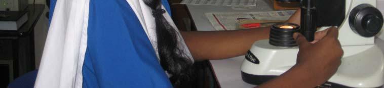
50 Loss of waterbodies Frequent flooding loss of life and property Decline in ground water table Changes in local l climate Traffic bottlenecks Enhanced pollution levels Increased population, lti aggressive behaviour Lack of Governance Dead city 2005 (Garden city in 70 s, Garbage city in 2000)
51 Environment Education (school and colleges) Capacity Building (Training Programmes, workshops and Symposiums Lake series: Lake 2008) Create new lakes (urban environment) Database of wetlands, Spatial Decision Support Systems Advocacy and Sensitize Decision makers/planners


52


 ( A")
")


53 Create an Ecosystem Mini Forest In front of CES at IISc (1988) Western Ghats Liana near CES (1989) ( A unique spot in Bangalore) Temperature always 2 5 degrees lower Temperature always 2.5 degrees lower than Malleswaram Groundwater table is 15 (compared to 140 earlier)
54
55


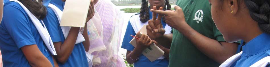


56 Di t C ll ti t V th Diatom Collection at Varthur Lake with School Children (Karthick interacting with school kids)


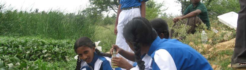


57 Diatom Collection at Varthur & Siddapura Lake with School Children


58 School kids at IISc


59 KIDS RESEARCHER CMEN GPAR 10 µ Not to Scale NPAL
60 Ramachandra T.V., Durga Madhab Mahapathra, Karthick B and Gordon (2009). Milking diatoms for sustainable energy:bio chemical engineering versus gasoline secreting diatom solar panel. (invite) Ind.Eng.Chem.Res.48(19),Complex C materials II Special issue (October) in press.


61 Thank you all
Geographic Resources Decision Support System for land use, land cover dynamics analysis
 Proceedings of the FOSS/GRASS Users Conference - Bangkok, Thailand, 12-14 September 2004 Geographic Resources Decision Support System for land use, land cover dynamics analysis T. V. Ramachandra*+, Uttam
M.C.PALIWAL. Department of Civil Engineering NATIONAL INSTITUTE OF TECHNICAL TEACHERS TRAINING & RESEARCH, BHOPAL (M.P.), INDIA
, INDIA") INVESTIGATIONS ON THE ACCURACY ASPECTS IN THE LAND USE/LAND COVER MAPPING USING REMOTE SENSING SATELLITE IMAGERY By M.C.PALIWAL Department of Civil Engineering NATIONAL INSTITUTE OF TECHNICAL TEACHERS
INVESTIGATIONS ON THE ACCURACY ASPECTS IN THE LAND USE/LAND COVER MAPPING USING REMOTE SENSING SATELLITE IMAGERY By M.C.PALIWAL Department of Civil Engineering NATIONAL INSTITUTE OF TECHNICAL TEACHERS
URBAN WATERSHED RUNOFF MODELING USING GEOSPATIAL TECHNIQUES
 URBAN WATERSHED RUNOFF MODELING USING GEOSPATIAL TECHNIQUES DST Sponsored Research Project (NRDMS Division) By Prof. M. GOPAL NAIK Professor & Chairman, Board of Studies Email: mgnaikc@gmail.com Department
The Study of Impact of Urbanization on Urban Heat Island with Temperature Variation Analysis of MODIS Data Using Remote Sensing and GIS Technology
 Cloud Publications International Journal of Advanced Remote Sensing and GIS 2015, Volume 4, Issue 1, pp. 944-952, Article ID Tech-269 ISSN 2320-0243 Research Article Open Access The Study of Impact of
1. Introduction. Chaithanya, V.V. 1, Binoy, B.V. 2, Vinod, T.R. 2. Publication Date: 8 April DOI: https://doi.org/ /cloud.ijarsg.
 Cloud Publications International Journal of Advanced Remote Sensing and GIS 2017, Volume 6, Issue 1, pp. 2088-2096 ISSN 2320 0243, Crossref: 10.23953/cloud.ijarsg.112 Research Article Open Access Estimation
Spatio-temporal dynamics of Raichur City
 LA KE 2012 LAKE 2012: National Conference on Conservation and Management of Wetland Ecosystems Energy and Wetlands Research Group, Centre for Ecological Sciences, Indian Institute of Science, Bangalore
An Internet-based Agricultural Land Use Trends Visualization System (AgLuT)
") An Internet-based Agricultural Land Use Trends Visualization System (AgLuT) Prepared for Missouri Department of Natural Resources Missouri Department of Conservation 07-01-2000-12-31-2001 Submitted by
An Internet-based Agricultural Land Use Trends Visualization System (AgLuT) Prepared for Missouri Department of Natural Resources Missouri Department of Conservation 07-01-2000-12-31-2001 Submitted by
Effect of land use/land cover changes on runoff in a river basin: a case study
 Water Resources Management VI 139 Effect of land use/land cover changes on runoff in a river basin: a case study J. Letha, B. Thulasidharan Nair & B. Amruth Chand College of Engineering, Trivandrum, Kerala,
Landuse and Landcover change analysis in Selaiyur village, Tambaram taluk, Chennai
 Landuse and Landcover change analysis in Selaiyur village, Tambaram taluk, Chennai K. Ilayaraja Department of Civil Engineering BIST, Bharath University Selaiyur, Chennai 73 ABSTRACT The synoptic picture
1. Introduction. S.S. Patil 1, Sachidananda 1, U.B. Angadi 2, and D.K. Prabhuraj 3
 Cloud Publications International Journal of Advanced Remote Sensing and GIS 2014, Volume 3, Issue 1, pp. 525-531, Article ID Tech-249 ISSN 2320-0243 Research Article Open Access Machine Learning Technique
An Internet-based Agricultural Land Use Trends Visualization System (AgLuT)
") An Internet-based Agricultural Land Use Trends Visualization System (AgLuT) Second half yearly report 01-01-2001-06-30-2001 Prepared for Missouri Department of Natural Resources Missouri Department of
An Internet-based Agricultural Land Use Trends Visualization System (AgLuT) Second half yearly report 01-01-2001-06-30-2001 Prepared for Missouri Department of Natural Resources Missouri Department of
Relevance of Hyperspectral Data for Sustainable Management of Natural Resources
 Relevance of Hyperspectral Data for Sustainable Management of Natural Resources T. V. Ramachandra & Uttam Kumar Centre for Ecological Sciences, Indian Institute of Science Centre for Sustainable Technologies,
Analysis of Land Use And Land Cover Changes Using Gis, Rs And Determination of Deforestation Factors Using Unsupervised Classification And Clustering
 IOSR Journal of Applied Geology and Geophysics (IOSR-JAGG) e-issn: 2321 0990, p-issn: 2321 0982.Volume 5, Issue 3 Ver. II (May - June 2017), PP 73-78 www.iosrjournals.org Analysis of Land Use And Land
7.1 INTRODUCTION 7.2 OBJECTIVE
 7 LAND USE AND LAND COVER 7.1 INTRODUCTION The knowledge of land use and land cover is important for many planning and management activities as it is considered as an essential element for modeling and
LAND COVER CATEGORY DEFINITION BY IMAGE INVARIANTS FOR AUTOMATED CLASSIFICATION
 LAND COVER CATEGORY DEFINITION BY IMAGE INVARIANTS FOR AUTOMATED CLASSIFICATION Nguyen Dinh Duong Environmental Remote Sensing Laboratory Institute of Geography Hoang Quoc Viet Rd., Cau Giay, Hanoi, Vietnam
International Journal of Intellectual Advancements and Research in Engineering Computations
 ISSN:2348-2079 Volume-5 Issue-2 International Journal of Intellectual Advancements and Research in Engineering Computations Agricultural land investigation and change detection in Coimbatore district by
Environmental Impact Assessment Land Use and Land Cover CISMHE 7.1 INTRODUCTION
 7 LAND USE AND LAND COVER 7.1 INTRODUCTION The knowledge of land use and land cover is important for many planning and management activities as it is considered an essential element for modeling and understanding
APPLICATION OF LAND CHANGE MODELER FOR PREDICTION OF FUTURE LAND USE LAND COVER A CASE STUDY OF VIJAYAWADA CITY
 APPLICATION OF LAND CHANGE MODELER FOR PREDICTION OF FUTURE LAND USE LAND COVER A CASE STUDY OF VIJAYAWADA CITY K. Sundara Kumar 1, Dr. P. Udaya Bhaskar 2, Dr. K. Padmakumari 3 1 Research Scholar, 2,3
Abstract: About the Author:
 REMOTE SENSING AND GIS IN LAND USE PLANNING Sathees kumar P 1, Nisha Radhakrishnan 2 1 1 Ph.D Research Scholar, Department of Civil Engineering, National Institute of Technology, Tiruchirappalli- 620015,
MAPPING LAND USE/ LAND COVER OF WEST GODAVARI DISTRICT USING NDVI TECHNIQUES AND GIS Anusha. B 1, Sridhar. P 2
 MAPPING LAND USE/ LAND COVER OF WEST GODAVARI DISTRICT USING NDVI TECHNIQUES AND GIS Anusha. B 1, Sridhar. P 2 1 M. Tech. Student, Department of Geoinformatics, SVECW, Bhimavaram, A.P, India 2 Assistant
VISUALIZATION URBAN SPATIAL GROWTH OF DESERT CITIES FROM SATELLITE IMAGERY: A PRELIMINARY STUDY
 CO-439 VISUALIZATION URBAN SPATIAL GROWTH OF DESERT CITIES FROM SATELLITE IMAGERY: A PRELIMINARY STUDY YANG X. Florida State University, TALLAHASSEE, FLORIDA, UNITED STATES ABSTRACT Desert cities, particularly
Remote Sensing and GIS Applications for Hilly Watersheds SUBASHISA DUTTA DEPARTMENT OF CIVIL ENGINEERING IIT GUWAHATI
 Remote Sensing and GIS Applications for Hilly Watersheds SUBASHISA DUTTA DEPARTMENT OF CIVIL ENGINEERING IIT GUWAHATI Deciding Alternative Land Use Options in a Watershed Using GIS Source: Anita Prakash
Investigation of the Effect of Transportation Network on Urban Growth by Using Satellite Images and Geographic Information Systems
 Presented at the FIG Congress 2018, May 6-11, 2018 in Istanbul, Turkey Investigation of the Effect of Transportation Network on Urban Growth by Using Satellite Images and Geographic Information Systems
Lake 2016: Conference on Conservation and Sustainable Management
 LAND USE ASSESSMENT AND URBAN GROWTH MONITORING IN HYDERABAD REGION, INDIA. Chandan, M. C. 1, Vinay, S. 2, Bharath H. Aithal 1,2, Ramachandra, T.V. 2-4 1 RCGSIDM, IIT-Kharagpur. 2 Energy and Wetlands Research
Application of Remote Sensing Techniques for Change Detection in Land Use/ Land Cover of Ratnagiri District, Maharashtra
 IOSR Journal of Applied Geology and Geophysics (IOSR-JAGG) e-issn: 2321 0990, p-issn: 2321 0982.Volume 3, Issue 6 Ver. II (Nov. - Dec. 2015), PP 55-60 www.iosrjournals.org Application of Remote Sensing
Modeling Urban Land Cover Growth Dynamics Based on Land Change Modeler (LCM) Using Remote Sensing: A Case Study of Gurgaon, India
 Using Remote Sensing: A Case Study of Gurgaon, India") Advances in Computational Sciences and Technology ISSN 0973-6107 Volume 10, Number 10 (2017) pp. 2947-2961 Research India Publications http://www.ripublication.com Modeling Urban Land Cover Growth Dynamics
Advances in Computational Sciences and Technology ISSN 0973-6107 Volume 10, Number 10 (2017) pp. 2947-2961 Research India Publications http://www.ripublication.com Modeling Urban Land Cover Growth Dynamics
An experience with ILWIS in connection with National Geochemical Mapping by Geological Survey of India
 An experience with ILWIS in connection with National Geochemical Mapping by Geological Survey of India 1 S. Ramamurthy Geodata Division, Eastern Region, Geological Survey of India, Dk-6, Sector-2, Kolkata-91(ramasoma@yahoo.com)
Land Surface Temperature Analysis in an Urbanising Landscape through Multi- Resolution Data
 Land Surface Temperature Analysis in an Urbanising Landscape through Multi- Resolution Data Ramachandra T. V. 1,2,3 *, Bharath H. Aithal 1,2, Durgappa Sanna D. 2 1 Energy & Wetlands Research Group, Centre
The Road to Data in Baltimore
 Creating a parcel level database from high resolution imagery By Austin Troy and Weiqi Zhou University of Vermont, Rubenstein School of Natural Resources State and local planning agencies are increasingly
Land Use and Land Cover Mapping and Change Detection in Jind District of Haryana Using Multi-Temporal Satellite Data
 Land Use and Land Cover Mapping and Change Detection in Jind District of Haryana Using Multi-Temporal Satellite Data Ravindra Prawasi, M.P. Sharma, T. P. Babu, Om Pal, Saroj, Kirti Yadav, R.S.Hooda Abstract
International Journal of Scientific & Engineering Research, Volume 3, Issue 11, November ISSN
 International Journal of Scientific & Engineering Research, Volume 3, Issue 11, November-2012 1 ABSTRACT Land use land cover change detection of Ghatkesar mandal,rangareddy district using Remote sensing
Chitra Sood, R.M. Bhagat and Vaibhav Kalia Centre for Geo-informatics Research and Training, CSK HPKV, Palampur , HP, India
 APPLICATION OF SPACE TECHNOLOGY AND GIS FOR INVENTORYING, MONITORING & CONSERVATION OF MOUNTAIN BIODIVERSITY WITH SPECIAL REFERENCE TO MEDICINAL PLANTS Chitra Sood, R.M. Bhagat and Vaibhav Kalia Centre
Vegetation Change Detection of Central part of Nepal using Landsat TM
 Vegetation Change Detection of Central part of Nepal using Landsat TM Kalpana G. Bastakoti Department of Geography, University of Calgary, kalpanagb@gmail.com Abstract This paper presents a study of detecting
Using Geographic Information Systems and Remote Sensing Technology to Analyze Land Use Change in Harbin, China from 2005 to 2015
 Using Geographic Information Systems and Remote Sensing Technology to Analyze Land Use Change in Harbin, China from 2005 to 2015 Yi Zhu Department of Resource Analysis, Saint Mary s University of Minnesota,
Urban Hydrology - A Case Study On Water Supply And Sewage Network For Madurai Region, Using Remote Sensing & GIS Techniques
 RESEARCH INVENTY: International Journal of Engineering and Science ISBN: 2319-6483, ISSN: 2278-4721, Vol. 1, Issue 8 (November 2012), PP 07-12 www.researchinventy.com Urban Hydrology - A Case Study On
Free Geomatics Resources for Terrain Evaluation and Land Resource Assessment: a Case Study in Eastern Ghats Province of Southwestern Odisha, India
 Free Geomatics Resources for Terrain Evaluation and Land Resource Assessment: a Case Study in Eastern Ghats Province of Southwestern Odisha, India Bijay Kumar Sahu Geological Survey of India Southern Region
Spatial Pattern analysis of two urbanising Tier II cities in Karnataka using open source GIS - GRASS
 Spatial Pattern analysis of two urbanising Tier II cities in Karnataka using open source GIS - GRASS Bharath H. Aithal 1,2 and Ramachandra T.V 1,2,3 * 1 Energy & Wetlands Research Group, Centre for Ecological
Abstract. TECHNOFAME- A Journal of Multidisciplinary Advance Research. Vol.2 No. 2, (2013) Received: Feb.2013; Accepted Oct.
 Received: Feb.2013; Accepted Oct.") Vol.2 No. 2, 83-87 (2013) Received: Feb.2013; Accepted Oct. 2013 Landuse Pattern Analysis Using Remote Sensing: A Case Study of Morar Block, of Gwalior District, M.P. Subhash Thakur 1 Akhilesh Singh 2
Vol.2 No. 2, 83-87 (2013) Received: Feb.2013; Accepted Oct. 2013 Landuse Pattern Analysis Using Remote Sensing: A Case Study of Morar Block, of Gwalior District, M.P. Subhash Thakur 1 Akhilesh Singh 2
Watershed management
 WATERRESOURCES ~".""~"",--~'"- Watershed management using GRDSS ~m8ch8ndrtf~tam KIf!'Y8.r ::= :::J The dimensions of watershed management can be easily understood and improved by applications involving
RECENT DECLINE IN WATER BODIES IN KOLKATA AND SURROUNDINGS Subhanil Guha Department of Geography, Dinabandhu Andrews College, Kolkata, West Bengal
 International Journal of Science, Environment and Technology, Vol. 5, No 3, 2016, 1083 1091 ISSN 2278-3687 (O) 2277-663X (P) RECENT DECLINE IN WATER BODIES IN KOLKATA AND SURROUNDINGS Subhanil Guha Department
Short Term Course GEOINFORMATION SCIENCE AND TECHNOLOGY REMOTE SENSING, GPS, & GIS APPLICATIONS. Duration: 20 Weeks Two Batches in an year
 Short Term Course on GEOINFORMATION SCIENCE AND TECHNOLOGY REMOTE SENSING, GPS, & GIS APPLICATIONS Duration: 20 Weeks Two Batches in an year Information Brochure Dr. R. Satheesh Centre for Remote Sensing
INTERNATIONAL JOURNAL OF PURE AND APPLIED RESEARCH IN ENGINEERING AND TECHNOLOGY
 INTERNATIONAL JOURNAL OF PURE AND APPLIED RESEARCH IN ENGINEERING AND TECHNOLOGY A PATH FOR HORIZING YOUR INNOVATIVE WORK SPECIAL ISSUE FOR NATIONAL LEVEL CONFERENCE "SUSTAINABLE TECHNOLOGIES IN CIVIL
GIS and Remote Sensing
 Spring School Land use and the vulnerability of socio-ecosystems to climate change: remote sensing and modelling techniques GIS and Remote Sensing Katerina Tzavella Project Researcher PhD candidate Technology
CHANGE DETECTION USING REMOTE SENSING- LAND COVER CHANGE ANALYSIS OF THE TEBA CATCHMENT IN SPAIN (A CASE STUDY)
") CHANGE DETECTION USING REMOTE SENSING- LAND COVER CHANGE ANALYSIS OF THE TEBA CATCHMENT IN SPAIN (A CASE STUDY) Sharda Singh, Professor & Programme Director CENTRE FOR GEO-INFORMATICS RESEARCH AND TRAINING
CHANGE DETECTION USING REMOTE SENSING- LAND COVER CHANGE ANALYSIS OF THE TEBA CATCHMENT IN SPAIN (A CASE STUDY) Sharda Singh, Professor & Programme Director CENTRE FOR GEO-INFORMATICS RESEARCH AND TRAINING
HIGH RESOLUTION SATELLITE DATA FOR LAND USE/LAND COVER MAPPING IN ROHTAK DISTRICT HARYANA, INDIA
 HIGH RESOLUTION SATELLITE DATA FOR LAND USE/LAND COVER MAPPING IN ROHTAK DISTRICT HARYANA, INDIA MR. MUKESH KUMAR 1 AND MR.SANDEEP KUMAR 2 1. M.tech. Student, Department of Geography, M.D.University Rohtak,
Free Open Source Software for Geoinformatics (FOSS4G) A Practical Example System for Automated Geoscientific Analyses (SAGA)
 A Practical Example System for Automated Geoscientific Analyses (SAGA)") Free Open Source Software for Geoinformatics (FOSS4G) A Practical Example System for Automated Geoscientific Analyses (SAGA) Zlatko Horvat, MSc DGU Područni ured za katastar Čakovec My Motivation Give
Free Open Source Software for Geoinformatics (FOSS4G) A Practical Example System for Automated Geoscientific Analyses (SAGA) Zlatko Horvat, MSc DGU Područni ured za katastar Čakovec My Motivation Give
Quantifying Land Use/Cover Dynamics of Nainital Town (India) Using Remote Sensing and GIS Techniques
 Using Remote Sensing and GIS Techniques") Quantifying Land Use/Cover Dynamics of Nainital Town (India) Using Remote Sensing and GIS Techniques Jiwan Rawat 1*, Vivekananda Biswas 1 and Manish Kumar 1 1 Centre of Excellence for NRDMS in Uttarakhand,
Quantifying Land Use/Cover Dynamics of Nainital Town (India) Using Remote Sensing and GIS Techniques Jiwan Rawat 1*, Vivekananda Biswas 1 and Manish Kumar 1 1 Centre of Excellence for NRDMS in Uttarakhand,
UNITED NATIONS E/CONF.96/CRP. 5
 UNITED NATIONS E/CONF.96/CRP. 5 ECONOMIC AND SOCIAL COUNCIL Eighth United Nations Regional Cartographic Conference for the Americas New York, 27 June -1 July 2005 Item 5 of the provisional agenda* COUNTRY
STUDY OF NORMALIZED DIFFERENCE BUILT-UP (NDBI) INDEX IN AUTOMATICALLY MAPPING URBAN AREAS FROM LANDSAT TM IMAGERY
 INDEX IN AUTOMATICALLY MAPPING URBAN AREAS FROM LANDSAT TM IMAGERY") STUDY OF NORMALIZED DIFFERENCE BUILT-UP (NDBI) INDEX IN AUTOMATICALLY MAPPING URBAN AREAS FROM LANDSAT TM IMAGERY Dr. Hari Krishna Karanam Professor, Civil Engineering, Dadi Institute of Engineering &
STUDY OF NORMALIZED DIFFERENCE BUILT-UP (NDBI) INDEX IN AUTOMATICALLY MAPPING URBAN AREAS FROM LANDSAT TM IMAGERY Dr. Hari Krishna Karanam Professor, Civil Engineering, Dadi Institute of Engineering &
Landuse/Landcover Change Detection in Umshing- Mawkynroh of East Khasi Hills District, Meghalaya Using Spatial Information Technology
 International Journal of Scientific and Research Publications, Volume 6, Issue 1, January 2016 197 Landuse/Landcover Change Detection in Umshing- Mawkynroh of East Khasi Hills District, Meghalaya Using
Digital Change Detection Using Remotely Sensed Data for Monitoring Green Space Destruction in Tabriz
 Int. J. Environ. Res. 1 (1): 35-41, Winter 2007 ISSN:1735-6865 Graduate Faculty of Environment University of Tehran Digital Change Detection Using Remotely Sensed Data for Monitoring Green Space Destruction
Hydrologic Modelling of the Upper Malaprabha Catchment using ArcView SWAT
 Hydrologic Modelling of the Upper Malaprabha Catchment using ArcView SWAT Technical briefs are short summaries of the models used in the project aimed at nontechnical readers. The aim of the PES India
INTERNATIONAL JOURNAL OF GEOMATICS AND GEOSCIENCES Volume 7, No 1, 2016
 INTERNATIONAL JOURNAL OF GEOMATICS AND GEOSCIENCES Volume 7, No 1, 2016 Copyright by the authors - Licensee IPA- Under Creative Commons license 3.0 Research article ISSN 0976 4380 Urban sprawl and urban
VILLAGE INFORMATION SYSTEM (V.I.S) FOR WATERSHED MANAGEMENT IN THE NORTH AHMADNAGAR DISTRICT, MAHARASHTRA
 FOR WATERSHED MANAGEMENT IN THE NORTH AHMADNAGAR DISTRICT, MAHARASHTRA") VILLAGE INFORMATION SYSTEM (V.I.S) FOR WATERSHED MANAGEMENT IN THE NORTH AHMADNAGAR DISTRICT, MAHARASHTRA Abstract: The drought prone zone in the Western Maharashtra is not in position to achieve the agricultural
VILLAGE INFORMATION SYSTEM (V.I.S) FOR WATERSHED MANAGEMENT IN THE NORTH AHMADNAGAR DISTRICT, MAHARASHTRA Abstract: The drought prone zone in the Western Maharashtra is not in position to achieve the agricultural
National Atlas of Groundwater Dependent Ecosystems (GDE)
") National Atlas of Groundwater Dependent Ecosystems (GDE) Dr. Zaffar Sadiq Mohamed-Ghouse Executive Consultant & Practice Head-Spatial SKM, Australia zsadiq@globalskm.com Geospatial World Forum 2013, Rotterdam,
National Atlas of Groundwater Dependent Ecosystems (GDE) Dr. Zaffar Sadiq Mohamed-Ghouse Executive Consultant & Practice Head-Spatial SKM, Australia zsadiq@globalskm.com Geospatial World Forum 2013, Rotterdam,
DEVELOPMENT OF GPS PHOTOS DATABASE FOR LAND USE AND LAND COVER APPLICATIONS
 DEVELOPMENT OF GPS PHOTOS DATABASE FOR LAND USE AND LAND COVER APPLICATIONS An Ngoc VAN and Wataru TAKEUCHI Institute of Industrial Science University of Tokyo 4-6-1 Komaba, Meguro-ku, Tokyo 153-8505 Japan
A Case Study of Using Remote Sensing Data and GIS for Land Management; Catalca Region
 A Case Study of Using Remote Sensing Data and GIS for Land Management; Catalca Region Dr. Nebiye MUSAOGLU, Dr. Sinasi KAYA, Dr. Dursun Z. SEKER and Dr. Cigdem GOKSEL, Turkey Key words: Satellite data,
Advanced Image Analysis in Disaster Response
 Advanced Image Analysis in Disaster Response Creating Geographic Knowledge Thomas Harris ITT The information contained in this document pertains to software products and services that are subject to the
Changes in Land use Pattern due to Mining in Faridabad (Haryana)
") Changes in Land use Pattern due to Mining in Faridabad (Haryana) Manish Wadhawan 1, Shamshad Ahmad 2 1 Student of M. Tech Final Year, Department of Civil Engineering 2 Professor, Department of Civil Engineering
Changes in Land use Pattern due to Mining in Faridabad (Haryana) Manish Wadhawan 1, Shamshad Ahmad 2 1 Student of M. Tech Final Year, Department of Civil Engineering 2 Professor, Department of Civil Engineering
SWAMP GIS: A spatial decision support system for predicting and treating stormwater runoff. Michael G. Wing 1 * and Derek Godwin
 Journal of Spatial Hydrology Vol. 11, No. 2 Fall 2011 SWAMP GIS: A spatial decision support system for predicting and treating stormwater runoff Michael G. Wing 1 * and Derek Godwin Abstract SWAMP GIS
ART Based Reliable Method for Prediction of Agricultural Land Changes Using Remote Sensing
 Circuits and Systems, 2016, 7, 1051-1067 Published Online May 2016 in SciRes. http://www.scirp.org/journal/cs http://dx.doi.org/10.4236/cs.2016.76089 ART Based Reliable Method for Prediction of Agricultural
PREDICTION OF FUTURE LAND USE LAND COVER CHANGES OF VIJAYAWADA CITY USING REMOTE SENSING AND GIS
 PREDICTION OF FUTURE LAND USE LAND COVER CHANGES OF VIJAYAWADA CITY USING REMOTE SENSING AND GIS K. Sundara Kumar 1 *, N V A Sai Sankar Valasala 2, J V Subrahmanyam V 3, Mounika Mallampati 4 Kowsharajaha
LAND USE LAND COVER, CHANGE DETECTION OF FOREST IN KARWAR TALUK USING GEO-SPATIAL TECHNIQUES
 LAND USE LAND COVER, CHANGE DETECTION OF FOREST IN KARWAR TALUK USING GEO-SPATIAL TECHNIQUES Dr. A.G Koppad 1, Malini P.J 2 Professor and University Head (NRM) COF SIRSI, UAS DHARWAD Research Associate,
Land cover/land use mapping and cha Mongolian plateau using remote sens. Title. Author(s) Bagan, Hasi; Yamagata, Yoshiki. Citation Japan.
 Bagan, Hasi; Yamagata, Yoshiki. Citation Japan.") Title Land cover/land use mapping and cha Mongolian plateau using remote sens Author(s) Bagan, Hasi; Yamagata, Yoshiki International Symposium on "The Imp Citation Region Specific Systems". 6 Nove Japan.
Title Land cover/land use mapping and cha Mongolian plateau using remote sens Author(s) Bagan, Hasi; Yamagata, Yoshiki International Symposium on "The Imp Citation Region Specific Systems". 6 Nove Japan.
International Journal of Scientific Research and Reviews
 Case Study Available online www.ijsrr.org ISSN: 2279 0543 International Journal of Scientific Research and Reviews Study on the Pattern of Land Use /Land Cover Change in Sonipat District of NCR, A Block
- World-wide cities are growing at a rate of 2% annually (UN 1999). - (60,3%) will reside in urban areas in 2030.
. - (60,3%) will reside in urban areas in 2030.") THE EFFECTIVENESS OF NEW TECHNOLOGIES FOR URBAN LAND MANAGEMENT BAHAAEDDINE I. AL HADDAD Centro de Política de Suelo y Valoraciones Universidad Politécnica de Cataluña Barcelona, España www.upc.es/cpsv
THE EFFECTIVENESS OF NEW TECHNOLOGIES FOR URBAN LAND MANAGEMENT BAHAAEDDINE I. AL HADDAD Centro de Política de Suelo y Valoraciones Universidad Politécnica de Cataluña Barcelona, España www.upc.es/cpsv
10 emergency observation requests were successfully processed during the period
 ISRO s Inputs for the Sentinel Asia DPN and JPT meeting being held during 13-16, 16, November 2012 November 2012 Sentinel Asia Activity Spectrum - A dedicated Sentinel Asia server established at NRSC,
DEVELOPMENT OF FLOOD HAZARD VULNERABILITY MAP FOR ALAPPUZHA DISTRICT
 DEVELOPMENT OF FLOOD HAZARD VULNERABILITY MAP FOR ALAPPUZHA DISTRICT Ciya Maria Roy 1, Elsa Manoj 2, Harsha Joy 3, Sarin Ravi 4, Abhinanda Roy 5 1,2,3,4 U.G. Student, Department of Civil Engineering, MITS
Comparison of MLC and FCM Techniques with Satellite Imagery in A Part of Narmada River Basin of Madhya Pradesh, India
 Cloud Publications International Journal of Advanced Remote Sensing and GIS 013, Volume, Issue 1, pp. 130-137, Article ID Tech-96 ISS 30-043 Research Article Open Access Comparison of MLC and FCM Techniques
Progress and Land-Use Characteristics of Urban Sprawl in Busan Metropolitan City using Remote sensing and GIS
 Progress and Land-Use Characteristics of Urban Sprawl in Busan Metropolitan City using Remote sensing and GIS Homyung Park, Taekyung Baek, Yongeun Shin, Hungkwan Kim ABSTRACT Satellite image is very usefully
Display data in a map-like format so that geographic patterns and interrelationships are visible
 Vilmaliz Rodríguez Guzmán M.S. Student, Department of Geology University of Puerto Rico at Mayagüez Remote Sensing and Geographic Information Systems (GIS) Reference: James B. Campbell. Introduction to
APPLICATION OF REMOTE SENSING IN LAND USE CHANGE PATTERN IN DA NANG CITY, VIETNAM
 APPLICATION OF REMOTE SENSING IN LAND USE CHANGE PATTERN IN DA NANG CITY, VIETNAM Tran Thi An 1 and Vu Anh Tuan 2 1 Department of Geography - Danang University of Education 41 Le Duan, Danang, Vietnam
Remote Sensing and GIS Application in Change Detection Study Using Multi Temporal Satellite
 Cloud Publications International Journal of Advanced Remote Sensing and GIS 2013, Volume 2, Issue 1, pp. 374-378, Article ID Tech-181 ISSN 2320-0243 Case Study Open Access Remote Sensing and GIS Application
1. Introduction. Jai Kumar, Paras Talwar and Krishna A.P. Department of Remote Sensing, Birla Institute of Technology, Ranchi, Jharkhand, India
 Cloud Publications International Journal of Advanced Remote Sensing and GIS 2015, Volume 4, Issue 1, pp. 1026-1032, Article ID Tech-393 ISSN 2320-0243 Research Article Open Access Forest Canopy Density
Key words: Urbanization, urban footprint, landscape metrics.
 URBAN FOOTPRINT DYNAMICS IN INDIAN METROPOLIS PRIYADARSHINI J SHETTY, SHASHIKALA V, RAMACHANDRA T V CENTRE FOR INFRASTRUCTURE, SUSTAINABLE TRANSPORTATION AND URBAN PLANNING [CISTUP], INDIAN INSTITUTE OF
Report. Developing a course component on disaster management
 Report Developing a course component on disaster management By Chira Prangkio Tawee Chaipimonplin Department of Geography, Faculty of Social Sciences, Chiang Mai University Thailand Presented at Indian
Regional Centre for Mapping of Resources for Development (RCMRD), Nairobi, Kenya
, Nairobi, Kenya") Regional Centre for Mapping of Resources for Development (RCMRD), Nairobi, Kenya Introduction GIS ( 2 weeks: 10 days) Intakes: 7 th Jan, 4 th Feb,4 th March, 1 st April 6 th May, 3 rd June, 1 st July,
Regional Centre for Mapping of Resources for Development (RCMRD), Nairobi, Kenya Introduction GIS ( 2 weeks: 10 days) Intakes: 7 th Jan, 4 th Feb,4 th March, 1 st April 6 th May, 3 rd June, 1 st July,
Developing a Community Geographical Information System (GIS) in Rural India
 in Rural India") Developing a Community Geographical Information System (GIS) in Rural India Before rushing off and describing the unique challenges of developing a small scale GIS system India I better first describe
Developing a Community Geographical Information System (GIS) in Rural India Before rushing off and describing the unique challenges of developing a small scale GIS system India I better first describe
Spatial Data Science. Soumya K Ghosh
 Workshop on Data Science and Machine Learning (DSML 17) ISI Kolkata, March 28-31, 2017 Spatial Data Science Soumya K Ghosh Professor Department of Computer Science and Engineering Indian Institute of Technology,
LAND USE MAPPING AND MONITORING IN THE NETHERLANDS (LGN5)
") LAND USE MAPPING AND MONITORING IN THE NETHERLANDS (LGN5) Hazeu, Gerard W. Wageningen University and Research Centre - Alterra, Centre for Geo-Information, The Netherlands; gerard.hazeu@wur.nl ABSTRACT
LAND USE MAPPING AND MONITORING IN THE NETHERLANDS (LGN5) Hazeu, Gerard W. Wageningen University and Research Centre - Alterra, Centre for Geo-Information, The Netherlands; gerard.hazeu@wur.nl ABSTRACT
Part : General Situation of Surveying and Mapping. The Development of Surveying and Mapping in China. The contents
 The Development of Surveying and Mapping in China Dr. Ping Xiao China.P.R The contents Part : General Situation of Surveying and Mapping 1. The legal systems of surveying and mapping 2. The technologies
Yanbo Huang and Guy Fipps, P.E. 2. August 25, 2006
 Landsat Satellite Multi-Spectral Image Classification of Land Cover Change for GIS-Based Urbanization Analysis in Irrigation Districts: Evaluation in Low Rio Grande Valley 1 by Yanbo Huang and Guy Fipps,
INTERNATIONAL JOURNAL OF GEOMATICS AND GEOSCIENCES Volume 2, No 1, 2011
 INTERNATIONAL JOURNAL OF GEOMATICS AND GEOSCIENCES Volume 2, No 1, 2011 Copyright 2010 All rights reserved Integrated Publishing services Research article ISSN 0976 4380 Spatio-Temporal changes of Land
4. GIS Implementation of the TxDOT Hydrology Extensions
 4. GIS Implementation of the TxDOT Hydrology Extensions A Geographic Information System (GIS) is a computer-assisted system for the capture, storage, retrieval, analysis and display of spatial data. It
Spanish national plan for land observation: new collaborative production system in Europe
 ADVANCE UNEDITED VERSION UNITED NATIONS E/CONF.103/5/Add.1 Economic and Social Affairs 9 July 2013 Tenth United Nations Regional Cartographic Conference for the Americas New York, 19-23, August 2013 Item
DROUGHT ASSESSMENT USING SATELLITE DERIVED METEOROLOGICAL PARAMETERS AND NDVI IN POTOHAR REGION
 DROUGHT ASSESSMENT USING SATELLITE DERIVED METEOROLOGICAL PARAMETERS AND NDVI IN POTOHAR REGION Researcher: Saad-ul-Haque Supervisor: Dr. Badar Ghauri Department of RS & GISc Institute of Space Technology
Civil Engineering Journal
 Available online at www.civilejournal.org Civil Engineering Journal Vol. 1, No. 2, December, 2015 Comparative Study of Landsat and Aster Data by Morphometric Analysis Sujit Kumar a*, Tapasi Bhandary b
URBAN PATTERN ANALYSIS -MAJOR CITIES IN INDIA.
 URBA PATTER AALYSIS -MAJOR CITIES I IDIA. Sowmyashree. M.V 1,3, T.V. Ramachandra 1,2,3. 1 Centre for Ecological Science. 2 Centre for Sustainable Technology. 3 Centre for infrastructure, Sustainable Transportation
GEOGRAPHIC INFORMATION SYSTEMS (GIS) AT GERS LAB
 AT GERS LAB") GEOGRAPHIC INFORMATION SYSTEMS (GIS) AT GERS LAB Fernando Gilbes Santaella GERS Lab-Department of Geology University of Puerto Rico at Mayaguez fernando.gilbes@upr.edu Geological and Environmental Remote
GEOGRAPHIC INFORMATION SYSTEMS (GIS) AT GERS LAB Fernando Gilbes Santaella GERS Lab-Department of Geology University of Puerto Rico at Mayaguez fernando.gilbes@upr.edu Geological and Environmental Remote
ENV208/ENV508 Applied GIS. Week 1: What is GIS?
 ENV208/ENV508 Applied GIS Week 1: What is GIS? 1 WHAT IS GIS? A GIS integrates hardware, software, and data for capturing, managing, analyzing, and displaying all forms of geographically referenced information.
Geospatial Information for Urban Sprawl Planning and Policies Implementation in Developing Country s NCR Region: A Study of NOIDA City, India
 Geospatial Information for Urban Sprawl Planning and Policies Implementation in Developing Country s NCR Region: A Study of NOIDA City, India Dr. Madan Mohan Assistant Professor & Principal Investigator,
Land Use and Land Cover Detection by Different Classification Systems using Remotely Sensed Data of Kuala Tiga, Tanah Merah Kelantan, Malaysia
 Land Use and Land Cover Detection by Different Classification Systems using Remotely Sensed Data of Kuala Tiga, Tanah Merah Kelantan, Malaysia Wani Sofia Udin*, Zuhaira Nadhila Zahuri Faculty of Earth
Urban Area Delineation Using Pattern Recognition Technique
 Cloud Publications International Journal of Advanced Remote Sensing and GIS 2018, Volume 7, Issue 1, pp. 2466-2470 ISSN 2320 0243, Crossref: 10.23953/cloud.ijarsg.333 Methodology Article Urban Area Delineation
URBAN CHANGE DETECTION OF LAHORE (PAKISTAN) USING A TIME SERIES OF SATELLITE IMAGES SINCE 1972
 USING A TIME SERIES OF SATELLITE IMAGES SINCE 1972") URBAN CHANGE DETECTION OF LAHORE (PAKISTAN) USING A TIME SERIES OF SATELLITE IMAGES SINCE 1972 Omar Riaz Department of Earth Sciences, University of Sargodha, Sargodha, PAKISTAN. omarriazpk@gmail.com ABSTRACT
URBAN CHANGE DETECTION OF LAHORE (PAKISTAN) USING A TIME SERIES OF SATELLITE IMAGES SINCE 1972 Omar Riaz Department of Earth Sciences, University of Sargodha, Sargodha, PAKISTAN. omarriazpk@gmail.com ABSTRACT
Brief note on GIS and Mapping Training Course. Venue: Arnold Bhavan, 8-11, Ravindra Nagar, Habsiguda, Hyderabad Duration: Aug 2018
 Brief note on GIS and Mapping Training Course Venue: Arnold Bhavan, 8-11, Ravindra Nagar, Habsiguda, Hyderabad-500013 Duration: 17-18 Aug 2018 Water and Livelihoods Foundation organized a training program
Land Use/Land Cover Mapping in and around South Chennai Using Remote Sensing and GIS Techniques ABSTRACT
 Land Use/Land Cover Mapping in and around South Chennai Using Remote Sensing and GIS Techniques *K. Ilayaraja, Abhishek Singh, Dhiraj Jha, Kriezo Kiso, Amson Bharath institute of Science and Technology
GEOMATICS. Shaping our world. A company of
 GEOMATICS Shaping our world A company of OUR EXPERTISE Geomatics Geomatics plays a mayor role in hydropower, land and water resources, urban development, transport & mobility, renewable energy, and infrastructure
Remote sensing of sealed surfaces and its potential for monitoring and modeling of urban dynamics
 Remote sensing of sealed surfaces and its potential for monitoring and modeling of urban dynamics Frank Canters CGIS Research Group, Department of Geography Vrije Universiteit Brussel Herhaling titel van
Soil Erosion Calculation using Remote Sensing and GIS in Río Grande de Arecibo Watershed, Puerto Rico
 Soil Erosion Calculation using Remote Sensing and GIS in Río Grande de Arecibo Watershed, Puerto Rico Alejandra M. Rojas González Department of Civil Engineering University of Puerto Rico at Mayaguez.
REVIEW MAPWORK EXAM QUESTIONS 31 JULY 2014
 REVIEW MAPWORK EXAM QUESTIONS 31 JULY 2014 Lesson Description In this lesson we: Focus on key concepts and exam questions relating to GIS. Question 1 Test Yourself The most important component of a GIS