Geospatial Information for Urban Sprawl Planning and Policies Implementation in Developing Country s NCR Region: A Study of NOIDA City, India
|
|
|
- Morris Baldwin
- 6 years ago
- Views:
Transcription
1 Geospatial Information for Urban Sprawl Planning and Policies Implementation in Developing Country s NCR Region: A Study of NOIDA City, India Dr. Madan Mohan Assistant Professor & Principal Investigator, MRP-UGC JMI Central University, New Delhi Research Objectives: The objectives of the study are mentioned as follows: i. to detect the spatial patterns of land use land cover changes over the periods; ii. iii. to examine the impact of population growth trends and patterns on urban sprawl; to see the impact of industrial development on urban sprawl; iv. to explore suitable strategies for sustainable urban development. 1
2 Research Questions: i. What are the spatial patterns of land use land cover during 2001 to 2006? ii. How the spatial urban sprawl growth impacted rural-urban fringe of NOIDA city? iii. How are processes of economic development and industrialization boosted by the national and multi-national companies? iv. Which are the suitable strategies for sustainable urban development for one of the fast growing city NOIDA? Workflow Diagram of Methodology Study Area Frequency of Change Detection SOI Topographic Analogue Sheets IRS Satellite Multi-spectral Imagery Scanning Analogue to Digital Conversion Georeferencing & Mosaicing Vectorisation of spatial features Topology Building & Editing IRS-1C LISS-III IRS-P6 LISS-III Data Integration in GIS Spatial Features Data Non-Spatial Data Integration in GIS Pre-Image Processing Radiometric Correction Geometric Rectification Data Processing Bishrakh CD Block Ancillary Data Field Check Collateral Data Field Survey Socio-Economic: Rural & Urban Image Processing Feature Extraction Supervised Classification: Maximum Likelihood Classifier Algorithm Feature Selection: Average Divergence Transform Divergence Image Algebra Change Detection Accuracy Assessment Kappa Coefficient Thematic LULC Layers Computation of Model Shannon s Entropy Model GIS Techniques Overlay Analysis Quarry Building Thematic Layers Creation Post-Processing Quality Assurance Performed Change Detection using GIS & RS Algorithms Field Visits Training Sites Data Collection GCP GPS Framework Data Generation Results Processed Error Accuracy Assessment Change Detection Product Thematic LULC Layers Results: Digital Tabular Products LULC Thematic Layers Creation Attributes Thematic Layers Creation Entropy Model Spatial Layers Interpretation and Analysis 2


3 Entropy Model Degree of Dispersal Study Area: NOIDA City 3

4 Sub-Set Imagery of Study Area: 2001 and 2006 Multi-spectral Imagery Year 2001 Satellite IRS 1C Sensor LISS-III Multi-spectral Imagery Year 2006 Satellite IRS P6 Sensor LISS-III Origin of NOIDA City:
5 Land Use Land Cover Classification: 2001 and 2006 Pixel Based Land Use Land Cover Classification: 2001 Class Name Area % Area (in Sq Km) to Total Compact Settlement Sparse Settlement Open Space (Settlement) Green Cover Vegetation Scattered Vegetation Agricultural Land Yamuna River Totals Source: Computed from IRS-1C Satellite LISS III Imagery 5
")


6 Land Use Classification of NOIDA (Existing & Proposed) Training Sites Field Verification Checks: NOIDA Golf Course Greater NOIDA Expressway River Yamuna & its Barrage 6
 66.67% 65.43% 0.")

7 Accuracy Assessment of LULC Classification: 2001 & 2006 Class Name Producers Users Kappa Accuracy Accuracy Statistics Compact Settlement 88.89% 94.12% Sparse Settlement 96.00% 92.31% Open Space (Settlement) 66.67% 65.43% Green Cover Vegetation 89.32% 90.00% Scattered Vegetation 79.86% 80.23% Agricultural Land 98.82% 98.82% Yamuna River 92.78% 95.13% Trends of Population Growth & Density in NOIDA City (Existing and Proposed) 7

 GNOIDA Sector 40-41 239.4 @239.4 *212.8 (3) GNOIDA Udyog Kendra 452.5 @452.5 *207.5 (17) GNOIDA Toy City 70.9 @70.9 *31 (121) GNOIDA Mahila Udhyami Park 13.3 @13.3 *10.")
8 Industrial Estates in NOIDA & Greater NOIDA: 1999 Industrial Estates Area No of Plots/ No of Plots/ Management Developed Sheds Sheds Agency (in Acres) Allotted NOIDA Industrial Area Phase-I, II & III NOIDA NOIDA Export Processing Zone Min of Comm. Total GNOIDA Surajpur Site-A UPSIDC Surajpur Site-B UPSIDC Surajpur Site-C UPSIDC Surajpur Site-IV UPSIDC Surajpur Site-V UPSIDC EPIP UPSIDC Udyong vihar *186.6 (29) GNOIDA Sector-31 Kasna *81.98 (47) GNOIDA Sector *212.8 (3) GNOIDA Udyog Kendra *207.5 (17) GNOIDA Toy City *31 (121) GNOIDA Mahila Udhyami Park *10.7 (57) GNOIDA Total Grand Total Source: Compiled from the NCR Regional Plan 2000 NOIDA City Workers Classification by Industrial Categories:
9 Patterns of Urban Sprawl: 1991 & 2001 Spatial Patterns of Population Density: 1991 &
10 Urban Sprawl Growth Trends of NOIDA City: 1976 to 2006 Year Sources Area (in sq km) % Growth NOIDA GNOIDA TOTAL Rate 1976 SOI SOI IRS IRS Source: Survey of India, Topographic Sheets Indian Remote Sensing Satellite Imagery Spatial Urban Sprawl Growth Patterns of NOIDA City: 1976 to 1991 Source: Survey of India, Topographic Sheets Indian Remote Sensing Satellite 10
11 Spatial Urban Sprawl Growth Patterns of NOIDA City: 2001 to 2006 Source: Survey of India, Topographic Sheets Indian Remote Sensing Satellite Origin & Spatial Urban Sprawl Growth Patterns of NOIDA City: 1976 to


12 Spatial Growth Patterns of NOIDA City Region: 1976 to 2006 Impacting Factors of Urban Sprawl - NOIDA City HH Socio-Economic Profile Source: Computed from the Primary Field Survey 12

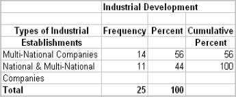
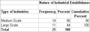
13 Urban Development Urban Amenities Social Infrastructures: Industrial Development: 13
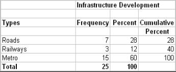
14 Modern Transport Infrastructure Development: Extension of Delhi Metro in NOIDA City Urban Development Planning - NOIDA Master Plan
15 Greater NOIDA Master Plan: 2021 Conclusions : An increase in the urban area comprises by the compact, sparse and open space settlements in NOIDA and GNOIDA. There is scattered urban sprawl in the peripheral area i.e. the rural-urban fringe. The entropy values are the highest in this case among the number of villages surrounding to the NOIDA city. The village Sadarpur Khadar has been agglomerated in the NOIDA City as an urban village in There has come up the number of industries and settlement sites all along the recently built the Greater NOIDA Expressway. A majority of 72 per cent has their own accommodation in urban village. More than 72 per cent of the household are living more than 15 years because they are the original inhabitants of urban village of NOIDA City. Urban amenities - the 88 per cent resident are satisfied with the type of educational facilities of school, college and university, primary health centres, municipal tape water supply etc. 56 per cent responses regarding the multi-national companies establishment Urban Sprawl factors - the govt. policies, educational institutions, amenities - health services, national and multi-national companies establishment 15
16 Recommendations: Urban expansions is to be planed on the non-fertile agricultural land for sustainable urban and environment development. Need for the spatial distribution of population which can reduce the pressure in the adjoining villages of the NOIDA city. The process of urban sprawl is engulfing to the rural villages The original inhabitants of the area are denied to avail such basic amenities Balance social and economic development to the rural-urban fringe area. So, people s opinion must be kept in the development planning process so that even sustainable urban development can taken place. Selected References: Jension, John R. (1996) Introductory Digital Image Processing: A Remote Sensing Perspective, New Delhi, Prentice Hall of India Pvt. Ltd. Lillesand, Tomas. M. and Kiefer, Ralph W. (2002) Remote Sensing and Image Interpretation, New York, John Wiley & Sons, Inc. Ansari, J.H., Sharma, A.K., Shaheer, M., Mahavir and Prakash, P. (2000) Revised Master Plan for Noida 2021, School of Planning and Architecture, New Delhi. Schowengerdt, Robert A. (1996) Techniques for Image Processing & Classification in Remote Sensing, Academic Press Maguire D.J., Goodchild MF and Rhind DW (ed.) Geographic Information Systems: Principles and Applications, United Kingdom, Longman Scientifi & Technical David Martin (1996) Geographic Information systems: Socioeconomic Applications, London, Routledge. Yeh, A.G.O., and Li, Xia (2001). Measurement and monitoring of urban sprawl in a rapidly growing region using entropy, Photogrammetric Engineering & Remote Sensing, 67(1), Zhang, Yan, Zhifeng Yang, and Wei Li. (2006) Analyses of urban ecosystem based on information entropy, Ecological Modelling, Vol. 197, No Reference Available On-line: Urban Sprawl Forms: 16
17 17
Abstract: About the Author:
 REMOTE SENSING AND GIS IN LAND USE PLANNING Sathees kumar P 1, Nisha Radhakrishnan 2 1 1 Ph.D Research Scholar, Department of Civil Engineering, National Institute of Technology, Tiruchirappalli- 620015,
UNITED NATIONS E/CONF.96/CRP. 5
 UNITED NATIONS E/CONF.96/CRP. 5 ECONOMIC AND SOCIAL COUNCIL Eighth United Nations Regional Cartographic Conference for the Americas New York, 27 June -1 July 2005 Item 5 of the provisional agenda* COUNTRY
Application of Remote Sensing Techniques for Change Detection in Land Use/ Land Cover of Ratnagiri District, Maharashtra
 IOSR Journal of Applied Geology and Geophysics (IOSR-JAGG) e-issn: 2321 0990, p-issn: 2321 0982.Volume 3, Issue 6 Ver. II (Nov. - Dec. 2015), PP 55-60 www.iosrjournals.org Application of Remote Sensing
Chapter 5. GIS The Global Information System
 Chapter 5 GIS The Global Information System What is GIS? We have just discussed GPS a simple three letter acronym for a fairly sophisticated technique to locate a persons or objects position on the Earth
Landuse and Landcover change analysis in Selaiyur village, Tambaram taluk, Chennai
 Landuse and Landcover change analysis in Selaiyur village, Tambaram taluk, Chennai K. Ilayaraja Department of Civil Engineering BIST, Bharath University Selaiyur, Chennai 73 ABSTRACT The synoptic picture
URBAN CHANGE DETECTION OF LAHORE (PAKISTAN) USING A TIME SERIES OF SATELLITE IMAGES SINCE 1972
 USING A TIME SERIES OF SATELLITE IMAGES SINCE 1972") URBAN CHANGE DETECTION OF LAHORE (PAKISTAN) USING A TIME SERIES OF SATELLITE IMAGES SINCE 1972 Omar Riaz Department of Earth Sciences, University of Sargodha, Sargodha, PAKISTAN. omarriazpk@gmail.com ABSTRACT
URBAN CHANGE DETECTION OF LAHORE (PAKISTAN) USING A TIME SERIES OF SATELLITE IMAGES SINCE 1972 Omar Riaz Department of Earth Sciences, University of Sargodha, Sargodha, PAKISTAN. omarriazpk@gmail.com ABSTRACT
Urban Hydrology - A Case Study On Water Supply And Sewage Network For Madurai Region, Using Remote Sensing & GIS Techniques
 RESEARCH INVENTY: International Journal of Engineering and Science ISBN: 2319-6483, ISSN: 2278-4721, Vol. 1, Issue 8 (November 2012), PP 07-12 www.researchinventy.com Urban Hydrology - A Case Study On
Spatiotemporal Analysis of Noida, Greater Noida and Surrounding Areas (India) Using Remote Sensing and GIS Approaches
 Using Remote Sensing and GIS Approaches") Spatiotemporal Analysis of Noida, Greater Noida and Surrounding Areas (India) Using Remote Sensing and GIS Approaches Gopal Krishna* Indian Agricultural Research Institute, New Delhi, India ABSTRACT Spatiotemporal
Spatiotemporal Analysis of Noida, Greater Noida and Surrounding Areas (India) Using Remote Sensing and GIS Approaches Gopal Krishna* Indian Agricultural Research Institute, New Delhi, India ABSTRACT Spatiotemporal
IMAGE CLASSIFICATION TOOL FOR LAND USE / LAND COVER ANALYSIS: A COMPARATIVE STUDY OF MAXIMUM LIKELIHOOD AND MINIMUM DISTANCE METHOD
 IMAGE CLASSIFICATION TOOL FOR LAND USE / LAND COVER ANALYSIS: A COMPARATIVE STUDY OF MAXIMUM LIKELIHOOD AND MINIMUM DISTANCE METHOD Manisha B. Patil 1, Chitra G. Desai 2 and * Bhavana N. Umrikar 3 1 Department
About the Author: Abstract:
 Temporal Analysis of Land use Pattern Changes of Noida, NCR Using Geospatial Tools Noyingbeni Kikon & Prafull Singh Amity Institute of Geo-informatics and Remote Sensing Amity University, Sector-125, Noida,
Abstract. TECHNOFAME- A Journal of Multidisciplinary Advance Research. Vol.2 No. 2, (2013) Received: Feb.2013; Accepted Oct.
 Received: Feb.2013; Accepted Oct.") Vol.2 No. 2, 83-87 (2013) Received: Feb.2013; Accepted Oct. 2013 Landuse Pattern Analysis Using Remote Sensing: A Case Study of Morar Block, of Gwalior District, M.P. Subhash Thakur 1 Akhilesh Singh 2
Vol.2 No. 2, 83-87 (2013) Received: Feb.2013; Accepted Oct. 2013 Landuse Pattern Analysis Using Remote Sensing: A Case Study of Morar Block, of Gwalior District, M.P. Subhash Thakur 1 Akhilesh Singh 2
Accuracy Assessment of Land Cover Classification in Jodhpur City Using Remote Sensing and GIS
 Accuracy Assessment of Land Cover Classification in Jodhpur City Using Remote Sensing and GIS S.L. Borana 1, S.K.Yadav 1 Scientist, RSG, DL, Jodhpur, Rajasthan, India 1 Abstract: A This study examines
International Journal of Scientific Research and Reviews
 Case Study Available online www.ijsrr.org ISSN: 2279 0543 International Journal of Scientific Research and Reviews Study on the Pattern of Land Use /Land Cover Change in Sonipat District of NCR, A Block
A Review of Concept of Peri-urban Area & Its Identification
 A Review of Concept of Peri-urban Area & Its Identification Ar. Manita Saxena Research Scholar Department of Architecture and Planning M.A.N.I.T, Bhopal Dr. Supriya Vyas Assistant Professor, Department
THE REVISION OF 1:50000 TOPOGRAPHIC MAP OF ONITSHA METROPOLIS, ANAMBRA STATE, NIGERIA USING NIGERIASAT-1 IMAGERY
 I.J.E.M.S., VOL.5 (4) 2014: 235-240 ISSN 2229-600X THE REVISION OF 1:50000 TOPOGRAPHIC MAP OF ONITSHA METROPOLIS, ANAMBRA STATE, NIGERIA USING NIGERIASAT-1 IMAGERY 1* Ejikeme, J.O. 1 Igbokwe, J.I. 1 Igbokwe,
USING GIS CARTOGRAPHIC MODELING TO ANALYSIS SPATIAL DISTRIBUTION OF LANDSLIDE SENSITIVE AREAS IN YANGMINGSHAN NATIONAL PARK, TAIWAN
 CO-145 USING GIS CARTOGRAPHIC MODELING TO ANALYSIS SPATIAL DISTRIBUTION OF LANDSLIDE SENSITIVE AREAS IN YANGMINGSHAN NATIONAL PARK, TAIWAN DING Y.C. Chinese Culture University., TAIPEI, TAIWAN, PROVINCE
M.C.PALIWAL. Department of Civil Engineering NATIONAL INSTITUTE OF TECHNICAL TEACHERS TRAINING & RESEARCH, BHOPAL (M.P.), INDIA
, INDIA") INVESTIGATIONS ON THE ACCURACY ASPECTS IN THE LAND USE/LAND COVER MAPPING USING REMOTE SENSING SATELLITE IMAGERY By M.C.PALIWAL Department of Civil Engineering NATIONAL INSTITUTE OF TECHNICAL TEACHERS
INVESTIGATIONS ON THE ACCURACY ASPECTS IN THE LAND USE/LAND COVER MAPPING USING REMOTE SENSING SATELLITE IMAGERY By M.C.PALIWAL Department of Civil Engineering NATIONAL INSTITUTE OF TECHNICAL TEACHERS
Use of Corona, Landsat TM, Spot 5 images to assess 40 years of land use/cover changes in Cavusbasi
 New Strategies for European Remote Sensing, Olui (ed.) 2005 Millpress, Rotterdam, ISBN 90 5966 003 X Use of Corona, Landsat TM, Spot 5 images to assess 40 years of land use/cover changes in Cavusbasi N.
International Journal of Scientific & Engineering Research, Volume 6, Issue 7, July ISSN
 International Journal of Scientific & Engineering Research, Volume 6, Issue 7, July-2015 1428 Accuracy Assessment of Land Cover /Land Use Mapping Using Medium Resolution Satellite Imagery Paliwal M.C &.
Victor C. NNAM, Bernard O. EKPETE and Obinna C. D. ANEJIONU, Nigeria
 IMPROVING STREET GUIDE MAPPING OF ENUGU SOUTH URBAN AREA THROUGH COMPUTER AIDED CARTOGRAPHY By Victor C. NNAM, Bernard O. EKPETE and Obinna C. D. ANEJIONU, Nigeria Presented at FIG Working Week 2012 Knowing
International Journal of Advancements in Research & Technology, Volume 2, Issue 7, July ISSN
 International Journal of Advancements in Research & Technology, Volume 2, Issue 7, July-2013 34 Remote Sensing & GIS Tools for Urban Studies in Akola city, Maharashtra. Khadri, S.F.R Chaitanya Pande and
M.Sc Geo-informatics Semester II Paper-VI : Advanced Course on Human Geography
 Paper-VI : Advanced Course on Human Geography Max Marks : 80 Time : 3 hrs. Unit 1 Human Geography: meaning, nature and approaches; human-environment relationship: determinism, possibilism and neo-determinism;
A Remote Sensing and GIS approach to trace the Densification in Residential Areas
 A Remote Sensing and GIS approach to trace the Densification in Residential Areas Valliappan AL Assistant Professor, School of Planning and Architecture, Vijayawada, India. Date:11/03/2015 What is Densification?
Operational Definitions of Urban, Rural and Urban Agglomeration for Monitoring Human Settlements
 Operational Definitions of Urban, Rural and Urban Agglomeration for Monitoring Human Settlements By Markandey Rai United Nations Human Settlements Programme PO Box-30030 Nairobi, Kenya Abstract The United
CHAPTER 2 REMOTE SENSING IN URBAN SPRAWL ANALYSIS
 9 CHAPTER 2 REMOTE SENSING IN URBAN SPRAWL ANALYSIS 2.1. REMOTE SENSING Remote sensing is the science of acquiring information about the Earth's surface without actually being in contact with it. This
Comparison of MLC and FCM Techniques with Satellite Imagery in A Part of Narmada River Basin of Madhya Pradesh, India
 Cloud Publications International Journal of Advanced Remote Sensing and GIS 013, Volume, Issue 1, pp. 130-137, Article ID Tech-96 ISS 30-043 Research Article Open Access Comparison of MLC and FCM Techniques
SOLUTIONS ADVANCED GIS. TekMindz are developing innovative solutions that integrate geographic information with niche business applications.
 ADVANCED GIS SOLUTIONS TekMindz are developing innovative solutions that integrate geographic information with niche business applications. TEK INDZ TM GIS Services Overview At the leading edge of geospatial
Remote Sensing and GIS Application in Change Detection Study Using Multi Temporal Satellite
 Cloud Publications International Journal of Advanced Remote Sensing and GIS 2013, Volume 2, Issue 1, pp. 374-378, Article ID Tech-181 ISSN 2320-0243 Case Study Open Access Remote Sensing and GIS Application
Progress and Land-Use Characteristics of Urban Sprawl in Busan Metropolitan City using Remote sensing and GIS
 Progress and Land-Use Characteristics of Urban Sprawl in Busan Metropolitan City using Remote sensing and GIS Homyung Park, Taekyung Baek, Yongeun Shin, Hungkwan Kim ABSTRACT Satellite image is very usefully
Digital Change Detection Using Remotely Sensed Data for Monitoring Green Space Destruction in Tabriz
 Int. J. Environ. Res. 1 (1): 35-41, Winter 2007 ISSN:1735-6865 Graduate Faculty of Environment University of Tehran Digital Change Detection Using Remotely Sensed Data for Monitoring Green Space Destruction
URBAN SPRAWL AND SPATIO TEMPORAL ANALYSIS OF HISAR CITY IN HARYANA USING REMOTE SENSING & GIS TECNOLOGY
 URBAN SPRAWL AND SPATIO TEMPORAL ANALYSIS OF HISAR CITY IN HARYANA USING REMOTE SENSING & GIS TECNOLOGY Shashikant 1, Pallavi Singh 2, R. D. Doi 3, Ankur Sharma 4, Ravinder Kumar 5, Parveen Bhatti 6 Abstract
Anjana Dewanji, Anindita Chatterjee & Achyut Kumar Banerjee. Agricultural & Ecological Research Unit Indian Statistical Institute Kolkata, India
 Anjana Dewanji, Anindita Chatterjee & Achyut Kumar Banerjee Agricultural & Ecological Research Unit Indian Statistical Institute Kolkata, India World wide distribution Distribution in India Present scenario
VISUALIZATION URBAN SPATIAL GROWTH OF DESERT CITIES FROM SATELLITE IMAGERY: A PRELIMINARY STUDY
 CO-439 VISUALIZATION URBAN SPATIAL GROWTH OF DESERT CITIES FROM SATELLITE IMAGERY: A PRELIMINARY STUDY YANG X. Florida State University, TALLAHASSEE, FLORIDA, UNITED STATES ABSTRACT Desert cities, particularly
A Logistic Regression Method for Urban growth modeling Case Study: Sanandaj City in IRAN
 A Logistic Regression Method for Urban growth modeling Case Study: Sanandaj City in IRAN Sassan Mohammady GIS MSc student, Dept. of Surveying and Geomatics Eng., College of Eng. University of Tehran, Tehran,
APPLICATION OF LAND CHANGE MODELER FOR PREDICTION OF FUTURE LAND USE LAND COVER A CASE STUDY OF VIJAYAWADA CITY
 APPLICATION OF LAND CHANGE MODELER FOR PREDICTION OF FUTURE LAND USE LAND COVER A CASE STUDY OF VIJAYAWADA CITY K. Sundara Kumar 1, Dr. P. Udaya Bhaskar 2, Dr. K. Padmakumari 3 1 Research Scholar, 2,3
The main objectives of the present study are mentioned as follows:
 Dr. Madan Mohan Assistant Professor of Geography Project Director, ICSSR (MoHRD), ND. The main objectives of the present study are mentioned as follows: to geovisualize population pressure on urban landscape;
Critical Assessment of Land Use Land Cover Dynamics Using Multi-Temporal Satellite Images
 Environments 2015, 2, 61-90; doi:10.3390/environments2010061 OPEN ACCESS environments ISSN 2076-3298 www.mdpi.com/journal/environments Article Critical Assessment of Land Use Land Cover Dynamics Using
Submitted to: Central Coalfields Limited Ranchi, Jharkhand. Ashoka & Piparwar OCPs, CCL
 Land Restoration / Reclamation Monitoring of more than 5 million cu. m. (Coal + OB) Capacity Open Cast Coal Mines of Central Coalfields Limited Based on Satellite Data for the Year 2013 Ashoka & Piparwar
Mapping and Spatial Characterisation of Major Urban Centres in Parts of South Eastern Nigeria with Nigeriasat-1 Imagery
 Mapping and Spatial Characterisation of Major Urban Centres in Parts of South Eastern Nigeria with Joel I. IGBOKWE, Nigeria Key words: Urban Planning, Urban growth, Urban Infrastructure, Landuse, Satellite
An Investigation of Reliability on Remote Sensing and GIS Data as an Aid to Urban Development Plan: A Case Study on Bhopal
 An Investigation of Reliability on Remote Sensing and GIS Data as an Aid to Urban Development Plan: A Case Study on Bhopal Abstract This study investigates the four criterias - namely scale of GIS map,
CHANGES IN VIJAYAWADA CITY BY REMOTE SENSING AND GIS
 International Journal of Civil Engineering and Technology (IJCIET) Volume 8, Issue 5, May 2017, pp.217 223, Article ID: IJCIET_08_05_025 Available online at http://www.ia aeme.com/ijciet/issues.asp?jtype=ijciet&vtyp
GEOG 377 Introduction to Geographic Information Systems, Spring, 2002 Page: 1/6
 GEOG 377 Introduction to Geographic Information Systems, Spring, 2002 Page: 1/6 GEOG 377: An Introduction to Geographic Information Systems Date: Feb. 26, 2002 Instructor: A-Xing Zhu, 421 Science Hall,
USING LANDSAT IN A GIS WORLD
 USING LANDSAT IN A GIS WORLD RACHEL MK HEADLEY; PHD, PMP STEM LIAISON, ACADEMIC AFFAIRS BLACK HILLS STATE UNIVERSITY This material is based upon work supported by the National Science Foundation under
7.1 INTRODUCTION 7.2 OBJECTIVE
 7 LAND USE AND LAND COVER 7.1 INTRODUCTION The knowledge of land use and land cover is important for many planning and management activities as it is considered as an essential element for modeling and
INTERNATIONAL JOURNAL OF GEOMATICS AND GEOSCIENCES Volume 4, No 1, 2013
 INTERNATIONAL JOURNAL OF GEOMATICS AND GEOSCIENCES Volume 4, No 1, 2013 Copyright 2010 All rights reserved Integrated Publishing services Research article ISSN 0976 4380 Spatio-temporal analysis of land
The Positional and Thematic Accuracy for Analysis of Multi-Temporal Satellite Images on Mangrove Areas
 The Positional and Thematic Accuracy for Analysis of Multi-Temporal Satellite Images on Mangrove Areas Paulo Rodrigo Zanin¹, Carlos Antonio O. Vieira² ¹Universidade Federal de Santa Catarina, Campus Universitário
Overview of Remote Sensing in Natural Resources Mapping
 Overview of Remote Sensing in Natural Resources Mapping What is remote sensing? Why remote sensing? Examples of remote sensing in natural resources mapping Class goals What is Remote Sensing A remote sensing
Urban Growth Analysis In Akure Metropolis
 Urban Growth Analysis In Akure Metropolis Olaoluwa A. Idayat, Samson A. Samuel, Muibi K.H, Ogbole John, Alaga A, T., Ajayi Victoria Abstract: Urban Land use changes, quantification and the analysis of
Presented to Sub-regional workshop on integration of administrative data, big data and geospatial information for the compilation of SDG indicators
 Presented to Sub-regional workshop on integration of administrative data, big data and geospatial information for the compilation of SDG indicators 23-25 April,2018 Addis Ababa, Ethiopia By: Deogratius
SATELLITE REMOTE SENSING
 SATELLITE REMOTE SENSING of NATURAL RESOURCES David L. Verbyla LEWIS PUBLISHERS Boca Raton New York London Tokyo Contents CHAPTER 1. SATELLITE IMAGES 1 Raster Image Data 2 Remote Sensing Detectors 2 Analog
Land Restoration /Reclamation Monitoring of Opencast Coal Mines of WCL Based On Satellite Data for the Year 2009 CMPDI. A Miniratna Company
 Land Restoration /Reclamation Monitoring of Opencast Coal Mines of WCL Based On Satellite Data for the Year 2009 CMPDI A Miniratna Company Land Restoration /Reclamation Monitoring of Opencast Coal Mines
The Road to Data in Baltimore
 Creating a parcel level database from high resolution imagery By Austin Troy and Weiqi Zhou University of Vermont, Rubenstein School of Natural Resources State and local planning agencies are increasingly
ANALYSIS OF URBAN PLANNING IN ISA TOWN USING GEOGRAPHIC INFORMATION SYSTEMS TECHNIQUES
 ANALYSIS OF URBAN PLANNING IN ISA TOWN USING GEOGRAPHIC INFORMATION SYSTEMS TECHNIQUES Lamya HAIDER, Prof. Mohamed AIT BELAID (*) Corre, and Dr. Anwar S. Khalil Arabian Gulf University (AGU), College of
Module - 3 GIS MAPPING, MIS AND GIS UNDER RAY
 Module - 3 1 GIS MAPPING, MIS AND GIS MIS INTEGRATION UNDER RAY Role of GIS & MIS under RAY Under the scheme, two step implementation strategy has been adopted i.e. preparation of SFCPoAs on whole city
THE ROLE OF GEOSPATIAL TECHNOLOGY IN SOCIAL AMENITIES FOR RURAL DEVELOPMENT
 THE ROLE OF GEOSPATIAL TECHNOLOGY IN SOCIAL AMENITIES FOR RURAL DEVELOPMENT ANAND P. PANDIT, P.G. Department of Geography, New Arts Commerce and Science College, Ahmednagar. (MS) INDIA MADHUKAR R. KARALE
Introduction to GIS. Dr. M.S. Ganesh Prasad
 Introduction to GIS Dr. M.S. Ganesh Prasad Department of Civil Engineering The National Institute of Engineering, MYSORE ganeshprasad.nie@gmail.com 9449153758 Geographic Information System (GIS) Information
Compact guides GISCO. Geographic information system of the Commission
 Compact guides GISCO Geographic information system of the Commission What is GISCO? GISCO, the Geographic Information System of the COmmission, is a permanent service of Eurostat that fulfils the requirements
INSTITUTE OF TOWN PLANNERS, INDIA TOWN PLANNING EXAMINATION BOARD ASSOCIATESHIP EXAMINATION
 SUBJECT: C.1.1. Planning Theory Maximum Marks: 20 1. What is Rational Planning Model? Discuss its main features. 2. Discuss the salient features of Advocacy Planning Theory. 3. Discuss David Harvey s contribution
Submitted to Central Coalfields Limited BHURKUNDA OCP, CCL
 Land Restoration / Reclamation Monitoring of Open Cast Coal Mines of Central Coalfields Limited producing less than 5 m cu m. (Coal+ OB) based on Satellite Data for the Year 2013 BHURKUNDA OCP, CCL Submitted
Landuse Pattern Analysis Using Remote Sensing: A Case Study of Mau District, India
 Available online at www.scholarsresearchlibrary.com Archives of Applied Science Research, 2011, 3 (5):10-16 (http://scholarsresearchlibrary.com/archive.html) ISSN 0975-508X CODEN (USA) AASRC9 Landuse Pattern
Landuse/Landcover Change Detection in Umshing- Mawkynroh of East Khasi Hills District, Meghalaya Using Spatial Information Technology
 International Journal of Scientific and Research Publications, Volume 6, Issue 1, January 2016 197 Landuse/Landcover Change Detection in Umshing- Mawkynroh of East Khasi Hills District, Meghalaya Using
Coalfields Limited. Based on Satellite Data for the Year Central Coalfields Limited Ranchi, Jharkhand. Submitted to:
 Land Restoration / Reclamation Monitoring of less than 5 m cu. m. (Coal + OB) Capacity Open Cast Coal Mines of Central Coalfields Limited Based on Satellite Data for the Year 2011. N URIMARI (BIRSA) OCP,CCL
AN INVESTIGATION OF AUTOMATIC CHANGE DETECTION FOR TOPOGRAPHIC MAP UPDATING
 AN INVESTIGATION OF AUTOMATIC CHANGE DETECTION FOR TOPOGRAPHIC MAP UPDATING Patricia Duncan 1 & Julian Smit 2 1 The Chief Directorate: National Geospatial Information, Department of Rural Development and
Cadcorp Introductory Paper I
 Cadcorp Introductory Paper I An introduction to Geographic Information and Geographic Information Systems Keywords: computer, data, digital, geographic information systems (GIS), geographic information
Land Use Changing Scenario at Kerniganj Thana of Dhaka District Using Remote Sensing and GIS
 Research Paper Land Use Changing Scenario at Kerniganj Thana of Dhaka District Using Remote Sensing and GIS Farzana Raihan 1 * and Nowrine Kaiser 1 1 Assistant Professor, Department of Forestry and Environment
Identification of Land use and Land cover Changes using Remote Sensing and GIS
 Identification of Land use and Land cover Changes using Remote Sensing and GIS N. Nagarajan and. S. Poongothai Abstract This study reveals to identify the changes of land use/land cover of rural agricultural
GIS Geographical Information Systems. GIS Management
 GIS Geographical Information Systems GIS Management Difficulties on establishing a GIS Funding GIS Determining Project Standards Data Gathering Map Development Recruiting GIS Professionals Educating Staff
The Study of Impact of Urbanization on Urban Heat Island with Temperature Variation Analysis of MODIS Data Using Remote Sensing and GIS Technology
 Cloud Publications International Journal of Advanced Remote Sensing and GIS 2015, Volume 4, Issue 1, pp. 944-952, Article ID Tech-269 ISSN 2320-0243 Research Article Open Access The Study of Impact of
APPLICATION OF REMOTE SENSING IN LAND USE CHANGE PATTERN IN DA NANG CITY, VIETNAM
 APPLICATION OF REMOTE SENSING IN LAND USE CHANGE PATTERN IN DA NANG CITY, VIETNAM Tran Thi An 1 and Vu Anh Tuan 2 1 Department of Geography - Danang University of Education 41 Le Duan, Danang, Vietnam
Combining Geospatial and Statistical Data for Analysis & Dissemination
 Combining Geospatial and Statistical Data for Analysis & Dissemination (with Special Reference to Qatar Census 2010) Presentation by Mansoor Al Malki, Director of IT Department Qatar Statistics Authority
Land Use/Land Cover Mapping in and around South Chennai Using Remote Sensing and GIS Techniques ABSTRACT
 Land Use/Land Cover Mapping in and around South Chennai Using Remote Sensing and GIS Techniques *K. Ilayaraja, Abhishek Singh, Dhiraj Jha, Kriezo Kiso, Amson Bharath institute of Science and Technology
Urban Area Delineation Using Pattern Recognition Technique
 Cloud Publications International Journal of Advanced Remote Sensing and GIS 2018, Volume 7, Issue 1, pp. 2466-2470 ISSN 2320 0243, Crossref: 10.23953/cloud.ijarsg.333 Methodology Article Urban Area Delineation
An Introduction to Geographic Information Systems (Fall, 2007)
") GEOG 377 Introduction to Geographic Information Systems, Fall, 2007 Page: 1/6 GEOG 377: An Introduction to Geographic Information Systems (Fall, 2007) Instructor: A-Xing Zhu, 255 Science Hall Phone: 262-0272
GEOG 377 Introduction to Geographic Information Systems, Fall, 2007 Page: 1/6 GEOG 377: An Introduction to Geographic Information Systems (Fall, 2007) Instructor: A-Xing Zhu, 255 Science Hall Phone: 262-0272
ENVIRONMENT AND NATURAL RESOURCES 3700 Introduction to Spatial Information for Environment and Natural Resources. (2 Credit Hours) Semester Syllabus
 Semester Syllabus") ENVIRONMENT AND NATURAL RESOURCES 3700 Introduction to Spatial Information for Environment and Natural Resources COURSE INSTRUCTOR: Dr. Kris Jaeger Assistant Professor 359 Kottman Hall (Mondays and Tuesdays)
ENVIRONMENT AND NATURAL RESOURCES 3700 Introduction to Spatial Information for Environment and Natural Resources COURSE INSTRUCTOR: Dr. Kris Jaeger Assistant Professor 359 Kottman Hall (Mondays and Tuesdays)
Urban Sprawl Mapping and Landuse Change Detection in and around Udupi Town: A Remote Sensing based Approach
 Urban Sprawl Mapping and Landuse Change Detection in and around Udupi Town: A Remote Sensing based Approach 1 K. Silambarasan, 2 M. S. Vinaya, 3 S. Suresh Babu 1,2,3 Department of Civil Engineering, 1,2,3
DATA SOURCES AND INPUT IN GIS. By Prof. A. Balasubramanian Centre for Advanced Studies in Earth Science, University of Mysore, Mysore
 DATA SOURCES AND INPUT IN GIS By Prof. A. Balasubramanian Centre for Advanced Studies in Earth Science, University of Mysore, Mysore 1 1. GIS stands for 'Geographic Information System'. It is a computer-based
NETWORK ANALYSIS FOR URBAN EMERGENCY SERVICES IN SOLAPUR CITY, INDIA: A GEOINFORMATIC APPROACH
 NETWORK ANALYSIS FOR URBAN EMERGENCY SERVICES IN SOLAPUR CITY, INDIA: A GEOINFORMATIC APPROACH Sagar P. Mali * & Yogesh A. Mane ** * Research Student, Department of Geography, Shivaji University, Kolhapur,
Table 4.1 Images used for the Study. Spatial Resolution (Meter) Resolution (Bits) 30 (For 6th band 120)
 Resolution (Bits) 30 (For 6th band 120)")
Changing Urban Built-up Area of Sangli-Miraj and Kupwad Municipal Corporation, Maharashtra (India): Using Satellite Data and GIS
: Using Satellite Data and GIS") Changing Urban Built-up Area of Sangli-Miraj and Kupwad Municipal Corporation, Maharashtra (India): Using Satellite Data and GIS Authors & Affiliation: Dr. Pradip Ashok Saymote Assist. Professor, P.G.
Changing Urban Built-up Area of Sangli-Miraj and Kupwad Municipal Corporation, Maharashtra (India): Using Satellite Data and GIS Authors & Affiliation: Dr. Pradip Ashok Saymote Assist. Professor, P.G.
Nnam, Victor CHUKWUEMEKA, Nnam, Godwin UCHECHUKWU and Nnam John OKWOR, Nigeria
 Assessment of Urban Development Planning using Supervised Classification of remotely sensed Imageries and GIS, A Case study of Independence Layout (Part of), Enugu, Nigeria. Nnam, Victor CHUKWUEMEKA, Nnam,
Modeling urban growth pattern for sustainable archaeological sites: A case study in Siem Reap, Cambodia
 Modeling urban growth pattern for sustainable archaeological sites: A case study in Siem Reap, CHANVOLEAK OURNG; DANIEL S. RODRIGUES; LÍGIA T. SILVA; RUI A. R. RAMOS Engineering School Department of Civil
INTERNATIONAL JOURNAL OF GEOMATICS AND GEOSCIENCES Volume 7, No 1, 2016
 INTERNATIONAL JOURNAL OF GEOMATICS AND GEOSCIENCES Volume 7, No 1, 2016 Copyright by the authors - Licensee IPA- Under Creative Commons license 3.0 Research article ISSN 0976 4380 Urban sprawl and urban
GEOMATICS. Shaping our world. A company of
 GEOMATICS Shaping our world A company of OUR EXPERTISE Geomatics Geomatics plays a mayor role in hydropower, land and water resources, urban development, transport & mobility, renewable energy, and infrastructure
DEPARTMENT OF GEOGRAPHY B.A. PROGRAMME COURSE DESCRIPTION
 DEPARTMENT OF GEOGRAPHY B.A. PROGRAMME COURSE DESCRIPTION (3 Cr. Hrs) (2340100) Geography of Jordan (University Requirement) This Course pursues the following objectives: - The study the physical geographical
CENSUS MAPPING WITH GIS IN NAMIBIA. BY Mrs. Ottilie Mwazi Central Bureau of Statistics Tel: October 2007
 CENSUS MAPPING WITH GIS IN NAMIBIA BY Mrs. Ottilie Mwazi Central Bureau of Statistics E-mail: omwazi@npc.gov.na Tel: + 264 61 283 4060 October 2007 Content of Presentation HISTORICAL BACKGROUND OF CENSUS
Systems (GIS) - with a focus on.
 - with a focus on.") Introduction to Geographic Information Systems (GIS) - with a focus on localizing the MDGs Carmelle J. Terborgh, Ph.D. ESRI www.esri.com Flying Blind Jul 24th 2003 The Economist We Live in Two Worlds Natural
Introduction to Geographic Information Systems (GIS) - with a focus on localizing the MDGs Carmelle J. Terborgh, Ph.D. ESRI www.esri.com Flying Blind Jul 24th 2003 The Economist We Live in Two Worlds Natural
[Kumar et. al., Vol.3 (Iss.9): September, 2016] ISSN: Impact Factor: (I2OR)
![[Kumar et. al., Vol.3 (Iss.9): September, 2016] ISSN: Impact Factor: (I2OR)](/thumbs/71/65950968.jpg "[Kumar et. al., Vol.3 (Iss.9): September, 2016] ISSN: Impact Factor: (I2OR)") IJETMR URBAN SPATIAL GROWTH AND LANDUSE CHANGE DETECTION ANALYSIS OF ALIGARH CITY, UTTAR PRADESH, INDIA USING HIGH RESOLUTION REMOTE SENSING DATA, GEOGRAPHICAL INFORMATION SYSTEM (GIS) AND GLOBAL POSITIONING
IJETMR URBAN SPATIAL GROWTH AND LANDUSE CHANGE DETECTION ANALYSIS OF ALIGARH CITY, UTTAR PRADESH, INDIA USING HIGH RESOLUTION REMOTE SENSING DATA, GEOGRAPHICAL INFORMATION SYSTEM (GIS) AND GLOBAL POSITIONING
Introduction to Geographic Information Systems
 Geog 58 Introduction to Geographic Information Systems, Fall, 2003 Page 1/8 Geography 58 Introduction to Geographic Information Systems Instructor: Lecture Hours: Lab Hours: X-period: Office Hours: Classroom:
Coastal Landuse Change Detection Using Remote Sensing Technique: Case Study in Banten Bay, West Java Island, Indonesia
 Kasetsart J. (Nat. Sci.) 39 : 159-164 (2005) Coastal Landuse Change Detection Using Remote Sensing Technique: Case Study in Banten Bay, West Java Island, Indonesia Puvadol Doydee ABSTRACT Various forms
Preparation of Database for Urban Development
 Preparation of Database for Urban Development By PunyaP OLI, 1. Chairman, ERMC (P) Ltd., Kathmandu, Nepal. Email: punyaoli@ermcnepal.com 2. Coordinator, Himalayan College of Geomatic Engineering and Land
STUDY OF NORMALIZED DIFFERENCE BUILT-UP (NDBI) INDEX IN AUTOMATICALLY MAPPING URBAN AREAS FROM LANDSAT TM IMAGERY
 INDEX IN AUTOMATICALLY MAPPING URBAN AREAS FROM LANDSAT TM IMAGERY") STUDY OF NORMALIZED DIFFERENCE BUILT-UP (NDBI) INDEX IN AUTOMATICALLY MAPPING URBAN AREAS FROM LANDSAT TM IMAGERY Dr. Hari Krishna Karanam Professor, Civil Engineering, Dadi Institute of Engineering &
STUDY OF NORMALIZED DIFFERENCE BUILT-UP (NDBI) INDEX IN AUTOMATICALLY MAPPING URBAN AREAS FROM LANDSAT TM IMAGERY Dr. Hari Krishna Karanam Professor, Civil Engineering, Dadi Institute of Engineering &
Urban Sprawl and its Changing Paradigms a Case Study of Jaipur City
 Journal for Research Volume 03 Issue 10 December 2017 ISSN: 2395-7549 Urban Sprawl and its Changing Paradigms a Case Study of Jaipur City Kritika Verma International College for Girls, Jaipur, Rajasthan,
GIS = Geographic Information Systems;
 What is GIS GIS = Geographic Information Systems; What Information are we talking about? Information about anything that has a place (e.g. locations of features, address of people) on Earth s surface,
Preparation of LULC map from GE images for GIS based Urban Hydrological Modeling
 International Conference on Modeling Tools for Sustainable Water Resources Management Department of Civil Engineering, Indian Institute of Technology Hyderabad: 28-29 December 2014 Abstract Preparation
INVESTIGATION LAND USE CHANGES IN MEGACITY ISTANBUL BETWEEN THE YEARS BY USING DIFFERENT TYPES OF SPATIAL DATA
 INVESTIGATION LAND USE CHANGES IN MEGACITY ISTANBUL BETWEEN THE YEARS 1903-2010 BY USING DIFFERENT TYPES OF SPATIAL DATA T. Murat Celikoyan, Elif Sertel, Dursun Zafer Seker, Sinasi Kaya, Uğur Alganci ITU,
Rural Gentrification: Middle Class Migration from Urban to Rural Areas. Sevinç Bahar YENIGÜL
 'New Ideas and New Generations of Regional Policy in Eastern Europe' International Conference 7-8 th of April 2016, Pecs, Hungary Rural Gentrification: Middle Class Migration from Urban to Rural Areas
Land Use/Cover Changes & Modeling Urban Expansion of Nairobi City
 Land Use/Cover Changes & Modeling Urban Expansion of Nairobi City Overview Introduction Objectives Land use/cover changes Modeling with Cellular Automata Conclusions Introduction Urban land use/cover types
Calculating Land Values by Using Advanced Statistical Approaches in Pendik
 Presented at the FIG Congress 2018, May 6-11, 2018 in Istanbul, Turkey Calculating Land Values by Using Advanced Statistical Approaches in Pendik Prof. Dr. Arif Cagdas AYDINOGLU Ress. Asst. Rabia BOVKIR
1. Introduction. S.S. Patil 1, Sachidananda 1, U.B. Angadi 2, and D.K. Prabhuraj 3
 Cloud Publications International Journal of Advanced Remote Sensing and GIS 2014, Volume 3, Issue 1, pp. 525-531, Article ID Tech-249 ISSN 2320-0243 Research Article Open Access Machine Learning Technique
2 nd Semester. Core Courses. C 2.1 City and Metropolitan Planning. Module 1: Urban Structure and Growth Implications
 2 nd Semester Core Courses C 2.1 City and Metropolitan Planning Module 1: Urban Structure and Growth Implications Growth of cities; cities as engine of growth; urban sprawl; land value, economic attributes