Evaluation of spatial heterogeneity for the design and layout of experimental sites
|
|
|
- Erica Dawson
- 5 years ago
- Views:
Transcription
1 Establisment of a long term experiment into tillage and traffic management. Part two: Evaluation of spatial heterogeneity for the design and layout of experimental sites Koloman Kristof 1,2, Emily K. Smith 1, Paula A. Misiewicz 1, Milan Kroulik 1,3, David R. White 1, Richard J. Godwin 1 1 Harper Adams University College, United Kingdom 2 Slovak University if Agriculture in Nitra, Slovakia 3 Czech University of Life Science, Czech Republic
2 Aim of the project: To develop practical recommendations for determining the spatial variability of potential experimental agronomic sites. Objectives: To monitor and evaluate the field to identify the spatial variability in soil properties for the selected field, To develop a methodology for good practise on doing field experiments, To make recommendations for potential layout and establishment of experiments on the selected field. Hypothesis: Field monitoring used in the Precision Farming (PF) to define the site-specific management zones could be used to identify uniform areas within the field for layout and design of potential experimental agronomic sites.
3 Background: Accurate treatment comparisons over a range of conditions are the primary objectives of most agricultural experiments. The natural spatial variability of soil properties adversely affects the accuracy and efficiency of agricultural experiments because error estimates based on observations from replicates of the same treatment are often inflated due to soil heterogeneity (Banton et al., 1997; Auerswald et al., 2001; Clay et al., 2001; Sudduth et al., 2001; Sudduth et al., 2003; Mueller et al., 2003; Heiniger et al., 2003). As discussed the conventional soil sampling is costly and labourintensive, but dense measurements of soil conductivity (ECa) are relatively rapid and inexpensive (Kitchen et al., 1999; Smith et al., 2001).
 based on the historical field boundaries, parameters")
4 Experimental Site: Large Marsh field: 8.51 ha, Harper Adams University College, Shropshire, UK, evaluation of the uniformity of the selected field, field divided into 3 areas (A,B,C) based on the historical field boundaries, parameters considered: plot trial requirements topographic data soil and water related data crop performance and yield BLOCK NAME Distribution of soil series in field AREA [ha] B 3.45 C 1.42 A 3.32 SOIL SERIES AREA [ha] % of AREA Newport Claverley Pinder Astley Hall Salop Newport Pinder Ollerton Salop Claverley Salwick Ollerton Salop Spatial distribution of soil series in field (Beard, Soil Survey and Land Research Centre)
 - September 2011 Electromagnetic conductivity using Geonics EM-38, Geonics Ltd., Canada): SHALLOW (0-0.75m) and DEEP (0-1.")
5 Methodology: Topographic data: Elevation by RTK GPS Soil and water data: Electromagnetic conductivity using DUALEM-2S (DUALEM Inc., CANADA): SHALLOW (0-0.5 m) and DEEP (0-1.2 m) - September 2011 Electromagnetic conductivity using Geonics EM-38, Geonics Ltd., Canada): SHALLOW (0-0.75m) and DEEP (0-1.5 m) - April 2012 Crop performance and yield: NDVI data from Crop Circle ACS-210 (Holand Scientific Inc., USA) May 2012 Remote sensing of crop canopy (satellite images; SOYL Precision Farming, UK) May 2012 Yield map using Ceres 8000i (RDS Technology Ltd., UK) Data analysed using the classical statistics in GenStat (VSN International Ltd., UK) and geostatistics in in ArcGIS (ESRI Inc., USA).


]")

")
6 Performed: Classical statistical evaluation: by comparing Variance and Coefficient of variation [c.v.(%)] graphically expressed by Box-plot charts (see below) Variance: Coefficient of variation: where population mean is:
7 Results: classical statistics Boxplot variables charts with single grouping factor (A,B,C); 1 ECa m, 2 ECa m, 3 elevation Statistical parameter ECa SHALLOW (ms/m) ECa DEEP (ms/m) ELEVATION (m) A B C A B C A B C Mean Minimum Maximum s.d s.e.m Variance c.v. (%)


8 Geostatistical evaluation: ordinary kriging interpolation The distance where the model first flattens is known as the range. Sample locations separated by distances closer than the range are spatially autocorrelated, whereas locations farther apart than the range are not. Model of spherical semivariogram: Expression of semivariance:
9 Results: geostatistics Spatial distribution of measured parameter divided into evaluated areas (1 ECa m; 2 ECa m; 3 Elevation) ECa SHALLOW (0-0.5 m) ECa DEEP (0-1.2 m) A A ELEVATION (m above sea level) Parameter B C B C A B C Nugget C Sill C0+C Range A0(m) C0/(C0+C) Model Spherical Spherical Spherical


10 Results: soil, crop performance and yields
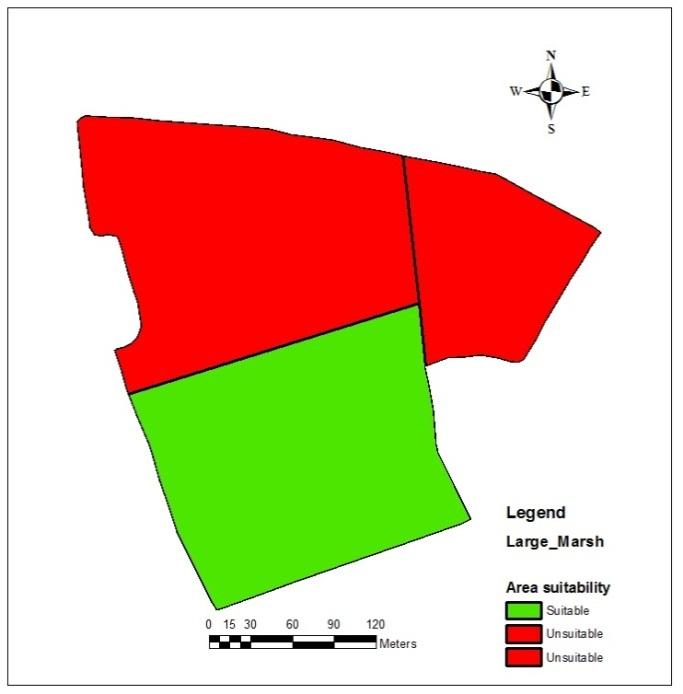

11 Recommendations: plot layout and design A B C A
12 Conclusions: This study evaluated a selection of commercially available rapid methods used to assess the within-field variability. The area A was found to have the lowest variability and, therefore, the establishment of an experimental study in this section is recommend. Further data analysis will provide recommended field survey protocols and methods to assess spatial heterogeneity for a design and layout of experimental sites. Employment of the recommended approach will ensure an estimation of significant differences between treatments (not influenced by heterogeneity of the field). It may also result in a reduction in required number of replications and experimental blocks.


13 Acknowledgement:
14 Thank you for your attention
Copyright The McGraw-Hill Companies, Inc. Permission required for reproduction or display.
 Chapter 15. SPATIAL INTERPOLATION 15.1 Elements of Spatial Interpolation 15.1.1 Control Points 15.1.2 Type of Spatial Interpolation 15.2 Global Methods 15.2.1 Trend Surface Models Box 15.1 A Worked Example
11/8/2018. Spatial Interpolation & Geostatistics. Kriging Step 1
 (Z i Z j ) 2 / 2 (Z i Zj) 2 / 2 Semivariance y 11/8/2018 Spatial Interpolation & Geostatistics Kriging Step 1 Describe spatial variation with Semivariogram Lag Distance between pairs of points Lag Mean
Spatial Interpolation & Geostatistics
 (Z i Z j ) 2 / 2 Spatial Interpolation & Geostatistics Lag Lag Mean Distance between pairs of points 1 y Kriging Step 1 Describe spatial variation with Semivariogram (Z i Z j ) 2 / 2 Point cloud Map 3
SPATIAL VARIABILITY OF AVAILABLE NUTRIENTS AND SOIL CARBON UNDER ARABLE CROPPING IN CANTERBURY
 SPATIAL VARIABILITY OF AVAILABLE NUTRIENTS AND SOIL CARBON UNDER ARABLE CROPPING IN CANTERBURY Weiwen Qiu, Denis Curtin and Mike Beare The New Zealand Institute for Plant & Food Research Limited, Private
Study on Delineation of Irrigation Management Zones Based on Management Zone Analyst Software
 Study on Delineation of Irrigation Management Zones Based on Management Zone Analyst Software Qiuxiang Jiang, Qiang Fu, Zilong Wang College of Water Conservancy & Architecture, Northeast Agricultural University,
PRODUCING PROBABILITY MAPS TO ASSESS RISK OF EXCEEDING CRITICAL THRESHOLD VALUE OF SOIL EC USING GEOSTATISTICAL APPROACH
 PRODUCING PROBABILITY MAPS TO ASSESS RISK OF EXCEEDING CRITICAL THRESHOLD VALUE OF SOIL EC USING GEOSTATISTICAL APPROACH SURESH TRIPATHI Geostatistical Society of India Assumptions and Geostatistical Variogram
A GIS Spatial Model for Defining Management Zones in Orchards Based on Spatial Clustering
 A GIS Spatial Model for Defining Management Zones in Orchards Based on Spatial Clustering A. Peeters 12, A. Ben-Gal 2 and A. Hetzroni 3 1 The Faculty of Food, Agriculture and Environmental Sciences, The
GLOBAL SYMPOSIUM ON SOIL ORGANIC CARBON, Rome, Italy, March 2017
 GLOBAL SYMPOSIUM ON SOIL ORGANIC CARBON, Rome, Italy, 2-23 March 207 Spatial Distribution of Organic Matter Content in Plough Layer of Balikh Flood Plain Soils Northeastern of Syria Hussam H. M. Husein
Relationships between Soil salinity and geopedological units in Saveh plain, Iran
 Available online at www.scholarsresearchlibrary.com Annals of Biological Research, 2012, 3 (5):2292-2296 (http://scholarsresearchlibrary.com/archive.html) ISSN 0976-1233 CODEN (USA): ABRNBW Relationships
SPATIAL VARIABILITY MAPPING OF N-VALUE OF SOILS OF MUMBAI CITY USING ARCGIS
 SPATIAL VARIABILITY MAPPING OF N-VALUE OF SOILS OF MUMBAI CITY USING ARCGIS RESHMA RASKAR - PHULE 1, KSHITIJA NADGOUDA 2 1 Assistant Professor, Department of Civil Engineering, Sardar Patel College of
Exploring the World of Ordinary Kriging. Dennis J. J. Walvoort. Wageningen University & Research Center Wageningen, The Netherlands
 Exploring the World of Ordinary Kriging Wageningen University & Research Center Wageningen, The Netherlands July 2004 (version 0.2) What is? What is it about? Potential Users a computer program for exploring
Geostatistics: Kriging
 Geostatistics: Kriging 8.10.2015 Konetekniikka 1, Otakaari 4, 150 10-12 Rangsima Sunila, D.Sc. Background What is Geostatitics Concepts Variogram: experimental, theoretical Anisotropy, Isotropy Lag, Sill,
Supplement of Scenario-based numerical modelling and the palaeo-historic record of tsunamis in Wallis and Futuna, Southwest Pacific
 Supplement of Nat. Hazards Earth Syst. Sci., 15, 1763 1784, 2015 http://www.nat-hazards-earth-syst-sci.net/15/1763/2015/ doi:10.5194/nhess-15-1763-2015-supplement Author(s) 2015. CC Attribution 3.0 License.
Lecture 5 Geostatistics
 Lecture 5 Geostatistics Lecture Outline Spatial Estimation Spatial Interpolation Spatial Prediction Sampling Spatial Interpolation Methods Spatial Prediction Methods Interpolating Raster Surfaces with
Use of Soil Electroconductivity in a Multistage Soil- Sampling Scheme
 Agronomy Publications Agronomy 2003 Use of Soil Electroconductivity in a Multistage Soil- Sampling Scheme Alison B. Tarr United States Department of Agriculture Kenneth J. Moore Iowa State University,
Extent of Radiological Contamination in Soil at Four Sites near the Fukushima Daiichi Power Plant, Japan (ArcGIS)
") Extent of Radiological Contamination in Soil at Four Sites near the Fukushima Daiichi Power Plant, Japan (ArcGIS) Contact: Ted Parks, AMEC Foster Wheeler, theodore.parks@amecfw.com, Alex Mikszewski, AMEC
Extent of Radiological Contamination in Soil at Four Sites near the Fukushima Daiichi Power Plant, Japan (ArcGIS) Contact: Ted Parks, AMEC Foster Wheeler, theodore.parks@amecfw.com, Alex Mikszewski, AMEC
Chapter 2 Sampling in Precision Agriculture
 Chapter 2 Sampling in Precision Agriculture R. Kerry, M.A. Oliver and Z.L. Frogbrook Abstract This chapter considers the importance of spatial scale in sampling and investigates various methods by which
DATA COLLECTION AND ANALYSIS METHODS FOR DATA FROM FIELD EXPERIMENTS
 DATA COLLECTION AND ANALYSIS METHODS FOR DATA FROM FIELD EXPERIMENTS S. Shibusawa and C. Haché Faculty of Agriculture, Tokyo University of Agriculture and Technology, Japan Keywords: Field experiments,
PURPOSE To develop a strategy for deriving a map of functional soil water characteristics based on easily obtainable land surface observations.
 IRRIGATING THE SOIL TO MAXIMIZE THE CROP AN APPROACH FOR WINTER WHEAT TO EFFICIENT AND ENVIRONMENTALLY SUSTAINABLE IRRIGATION WATER MANAGEMENT IN KENTUCKY Ole Wendroth & Chad Lee - Department of Plant
Detailed Low-Induction-Number EM Sounding to 9-m Depth
 Detailed Low-Induction-Number EM Sounding to 9-m Depth Richard S. Taylor, Dualem Inc. J. Scott Holladay, Geosensors Inc. David Lalonde, Geosensors Inc. SAGEEP, Charleston SC, April 11 Copyright 11, Dualem
Soil Moisture Modeling using Geostatistical Techniques at the O Neal Ecological Reserve, Idaho
 Final Report: Forecasting Rangeland Condition with GIS in Southeastern Idaho Soil Moisture Modeling using Geostatistical Techniques at the O Neal Ecological Reserve, Idaho Jacob T. Tibbitts, Idaho State
Report on Kriging in Interpolation
 Tabor Reedy ENVS421 3/12/15 Report on Kriging in Interpolation In this project I explored use of the geostatistical analyst extension and toolbar in the process of creating an interpolated surface through
SIMULATION STUDY OF SPATIAL- POISSON DATA ASSESSING INCLUSION OF SPATIAL CORRELATION AND NON- NORMALITY IN THE ANALYSIS
 Libraries Conference on Applied Statistics in Agriculture 2001-13th Annual Conference Proceedings SIMULATION STUDY OF SPATIAL- POISSON DATA ASSESSING INCLUSION OF SPATIAL CORRELATION AND NON- NORMALITY
COMPARISON OF DIGITAL ELEVATION MODELLING METHODS FOR URBAN ENVIRONMENT
 COMPARISON OF DIGITAL ELEVATION MODELLING METHODS FOR URBAN ENVIRONMENT Cahyono Susetyo Department of Urban and Regional Planning, Institut Teknologi Sepuluh Nopember, Indonesia Gedung PWK, Kampus ITS,
Spatial variation of soil and plant properties and its effects on the statistical design of a field experiment
 S. Afr. J. Plant Soil 009, () Spatial variation of soil and plant properties and its effects on the statistical design of a field experiment A.Venter *, M.F. Smith, D.J.Beukes, A.S. Claassens and M. Van
Beta-Binomial Kriging: An Improved Model for Spatial Rates
 Available online at www.sciencedirect.com ScienceDirect Procedia Environmental Sciences 27 (2015 ) 30 37 Spatial Statistics 2015: Emerging Patterns - Part 2 Beta-Binomial Kriging: An Improved Model for
Geostatistical Analyst for Deciding Optimal Interpolation Strategies for Delineating Compact Zones
 International Journal of Geosciences, 2011, 2, 585-596 doi:10.4236/ijg.2011.24061 Published Online November 2011 (http://www.scirp.org/journal/ijg) 585 Geostatistical Analyst for Deciding Optimal Interpolation
Data Break 8: Kriging the Meuse RiverBIOS 737 Spring 2004 p.1/27
 Data Break 8: Kriging the Meuse River BIOS 737 Spring 2004 Data Break 8: Kriging the Meuse RiverBIOS 737 Spring 2004 p.1/27 Meuse River: Reminder library(gstat) Data included in gstat library. data(meuse)
Modeling of Anticipated Subsidence due to Gas Extraction Using Kriging on Sparse Data Sets
 Modeling of Anticipated Subsidence due to Gas Extraction Using Kriging on Sparse Data Sets Matthew TAIT and Andrew HUNTER, Canada Key words: Kriging, Trend Surfaces, Sparse networks, Subsidence monitoring
Geotechnical verification of impact compaction
 PII-73 Geotechnical verification of impact compaction P. J. Waddell1, R. A. Moyle2 & R. J. Whiteley1 1 2 Coffey Geotechnics, Sydney, Australia Coffey Geotechnics, Harrogate, UK Abstract Remediation of
Investigation of Monthly Pan Evaporation in Turkey with Geostatistical Technique
 Investigation of Monthly Pan Evaporation in Turkey with Geostatistical Technique Hatice Çitakoğlu 1, Murat Çobaner 1, Tefaruk Haktanir 1, 1 Department of Civil Engineering, Erciyes University, Kayseri,
Index. Geostatistics for Environmental Scientists, 2nd Edition R. Webster and M. A. Oliver 2007 John Wiley & Sons, Ltd. ISBN:
 Index Akaike information criterion (AIC) 105, 290 analysis of variance 35, 44, 127 132 angular transformation 22 anisotropy 59, 99 affine or geometric 59, 100 101 anisotropy ratio 101 exploring and displaying
An Introduction to Pattern Statistics
 An Introduction to Pattern Statistics Nearest Neighbors The CSR hypothesis Clark/Evans and modification Cuzick and Edwards and controls All events k function Weighted k function Comparative k functions
An Introduction to Spatial Autocorrelation and Kriging
 An Introduction to Spatial Autocorrelation and Kriging Matt Robinson and Sebastian Dietrich RenR 690 Spring 2016 Tobler and Spatial Relationships Tobler s 1 st Law of Geography: Everything is related to
SPATIAL VARIABILITY OF NITROGEN SUPPLY ASSESSED USING SOIL AND PLANT BIOASSAYS
 SPATIAL VARIABILITY OF NITROGEN SUPPLY ASSESSED USING SOIL AND PLANT BIOASSAYS Weiwen Qiu 1, Paul Johnstone 2, Dirk Wallace 1, Nathan Arnold 2, Bruce Searle 2, Joanna Sharp 1, Mike Beare 1 and Denis Curtin
Spatial analysis. Spatial descriptive analysis. Spatial inferential analysis:
 Spatial analysis Spatial descriptive analysis Point pattern analysis (minimum bounding box, mean center, weighted mean center, standard distance, nearest neighbor analysis) Spatial clustering analysis
Rating of soil heterogeneity using by satellite images
 Rating of soil heterogeneity using by satellite images JAROSLAV NOVAK, VOJTECH LUKAS, JAN KREN Department of Agrosystems and Bioclimatology Mendel University in Brno Zemedelska 1, 613 00 Brno CZECH REPUBLIC
GEOSTATISTICS. Dr. Spyros Fountas
 GEOSTATISTICS Dr. Spyros Fountas Northing (m) 140550 140450 140350 Trent field Disturbed area Andover 140250 Panholes 436950 437050 437150 437250 437350 Easting (m) Trent Field Westover Farm (Blackmore,
Geostatistical Analysis of Spatial Variations of Groundwater Level using GIS in Banaskantha District, Gujarat, India
 IJSRD - International Journal for Scientific Research & Development Vol. 6, Issue 02, 2018 ISSN (online): 2321-0613 Geostatistical Analysis of Spatial Variations of Groundwater Level using GIS in Banaskantha
ISSUES AND APPROACHES TO COUPLING GIS TO AN IRRIGATION DISTRIBUTION NETWORK AND SEEPAGE LOSS MODELS ABSTRACT
 ISSUES AND APPROACHES TO COUPLING GIS TO AN IRRIGATION DISTRIBUTION NETWORK AND SEEPAGE LOSS MODELS Yanbo Huang 1, Milton Henry 2, David Flahive 3, Guy Fipps 4 ABSTRACT Geographic Information Systems (GIS)
Geostatistical analysis of surface soil texture from Zala county in western Hungary
 Geostatistical analysis of surface soil texture from Zala county in western Hungary K. Adhikari *,**, A. Guadagnini **, G. Toth * and T. Hermann *** * Land Management and Natural Hazards Unit, Institute
Optimization Design of Groundwater Level Monitoring Network Based on the Geo-Statistics Chen Jing
 nd International Conference on Science and Social Research (ICSSR 03) Optimization Design of Groundwater Level Monitoring etwork Based on the Geo-Statistics Chen Jing School of Earth Science & Engineering,
7 Geostatistics. Figure 7.1 Focus of geostatistics
 7 Geostatistics 7.1 Introduction Geostatistics is the part of statistics that is concerned with geo-referenced data, i.e. data that are linked to spatial coordinates. To describe the spatial variation
FLOOD HAZARD AND RISK ASSESSMENT IN MID- EASTERN PART OF DHAKA, BANGLADESH
 FLOOD HAZARD AND RISK ASSESSMENT IN MID- EASTERN PART OF DHAKA, BANGLADESH Muhammad MASOOD MEE07180 Supervisor: Prof. Kuniyoshi TAKEUCHI ABSTRACT An inundation simulation has been done for the mid-eastern
Spatial Analysis II. Spatial data analysis Spatial analysis and inference
 Spatial Analysis II Spatial data analysis Spatial analysis and inference Roadmap Spatial Analysis I Outline: What is spatial analysis? Spatial Joins Step 1: Analysis of attributes Step 2: Preparing for
Remote Sensing and Geographic Information System (GIS) Based Analysis of Historic Resources
 Based Analysis of Historic Resources") World War II Additional Material Remote Sensing and Geographic Information System (GIS) Based Analysis of Historic Resources By Nicole Vernon and Patrick O Day, GANDA Remote Sensing and Geographic Information
World War II Additional Material Remote Sensing and Geographic Information System (GIS) Based Analysis of Historic Resources By Nicole Vernon and Patrick O Day, GANDA Remote Sensing and Geographic Information
Geostatistical Approach for Spatial Interpolation of Meteorological Data
 Anais da Academia Brasileira de Ciências (2016) 88(4): 2121-2136 (Annals of the Brazilian Academy of Sciences) Printed version ISSN 0001-3765 / Online version ISSN 1678-2690 http://dx.doi.org/10.1590/0001-3765201620150103
How significantly different are your within field zones?
 Advances in Animal Biosciences: Precision Agriculture (ECPA) 2017, (2017), 8:2, pp 620 624 The Animal Consortium 2017 doi:10.1017/s2040470017000012 advances in animal biosciences How significantly different
GAMMA SOIL SURVEYS: FOR PRECISION SOIL MAPPING
 GAMMA SOIL SURVEYS: FOR PRECISION SOIL MAPPING CAROLYN HEDLEY, PIERRE ROUDIER, ANDREW MANDERSON, PAUL PETERSON LANDCARE RESEARCH MANAAKI WHENUA contact: hedleyc@landcareresearch.co.nz New Zealand & Australian
Introduction. Semivariogram Cloud
 Introduction Data: set of n attribute measurements {z(s i ), i = 1,, n}, available at n sample locations {s i, i = 1,, n} Objectives: Slide 1 quantify spatial auto-correlation, or attribute dissimilarity
University of California, Los Angeles Department of Statistics. Effect of variogram parameters on kriging weights
 University of California, Los Angeles Department of Statistics Statistics C173/C273 Instructor: Nicolas Christou Effect of variogram parameters on kriging weights We will explore in this document how the
Final Technical Report 2012
 Final Technical Report 2012 Project Title: Drought monitoring: a system for tracking plant available soil moisture based on the Oklahoma Mesonet Authors' Names and Affiliations: Tyson Ochsner Asst. Professor,
On dealing with spatially correlated residuals in remote sensing and GIS
 On dealing with spatially correlated residuals in remote sensing and GIS Nicholas A. S. Hamm 1, Peter M. Atkinson and Edward J. Milton 3 School of Geography University of Southampton Southampton SO17 3AT
Spatiotemporal Analysis of Solar Radiation for Sustainable Research in the Presence of Uncertain Measurements
 Spatiotemporal Analysis of Solar Radiation for Sustainable Research in the Presence of Uncertain Measurements Alexander Kolovos SAS Institute, Inc. alexander.kolovos@sas.com Abstract. The study of incoming
Assessment of Three Spatial Interpolation Models to Obtain the Best One for Cumulative Rainfall Estimation (Case study: Ramsar District)
") Assessment of Three Spatial Interpolation Models to Obtain the Best One for Cumulative Rainfall Estimation (Case study: Ramsar District) Hasan Zabihi, Anuar Ahmad, Mohamad Nor Said Department of Geoinformation,
Assessment of Three Spatial Interpolation Models to Obtain the Best One for Cumulative Rainfall Estimation (Case study: Ramsar District) Hasan Zabihi, Anuar Ahmad, Mohamad Nor Said Department of Geoinformation,
Geostatistical Density Mapping
 Geostatistical Density Mapping Sean A. McKenna and Barry Roberts (SNL) Brent Pulsipher & John Hathaway (PNNL) 2008 Partners in Environmental Technology Technical Symposium & Workshop Sandia is a multiprogram
Comparing efficiency of different sampling schemes to estimate yield and quality parameters in fruit orchards
 Comparing efficiency of different sampling schemes to estimate yield and quality parameters in fruit orchards J. Arnó 1, J.A. Martínez-Casasnovas, A. Uribeetxebarria 1, A. Escolà 1 and J.R. Rosell-Polo
RESEARCH ON THE SPATIAL VARIABILITY OF SOIL MOISTURE
 RESEARCH ON THE SPATIAL VARIABILITY OF SOIL MOISTURE Changli Zhang 1, Shuqiang Liu 2,*, Xianyue Zhang 2, Kezhu Tan 3 1 Engineering College, Northeast Agricultural University, Harbin, Heilongjiang, China,
Spatial Variability of Penetration Resistance on Pseudogley
 ORIGINAL SCIENTIFIC PAPER 9 Spatial Variability of Penetration Resistance on Pseudogley Igor BOGUNOVIC 1 ( ) Milan MESIC 1 Márta BIRKÁS 2 Summary Usually large numbers of measurements are required to describe
Remote Sensing Geographic Information Systems Global Positioning Systems
 Remote Sensing Geographic Information Systems Global Positioning Systems Assessing Seasonal Vegetation Response to Drought Lei Ji Department of Geography University of Nebraska-Lincoln AVHRR-NDVI: July
Texas A&M University. Zachary Department of Civil Engineering. Instructor: Dr. Francisco Olivera. CVEN 658 Civil Engineering Applications of GIS
 1 Texas A&M University Zachary Department of Civil Engineering Instructor: Dr. Francisco Olivera CVEN 658 Civil Engineering Applications of GIS The Use of ArcGIS Geostatistical Analyst Exploratory Spatial
ArcGIS for Geostatistical Analyst: An Introduction. Steve Lynch and Eric Krause Redlands, CA.
 ArcGIS for Geostatistical Analyst: An Introduction Steve Lynch and Eric Krause Redlands, CA. Outline - What is geostatistics? - What is Geostatistical Analyst? - Spatial autocorrelation - Geostatistical
CREATION OF DEM BY KRIGING METHOD AND EVALUATION OF THE RESULTS
 CREATION OF DEM BY KRIGING METHOD AND EVALUATION OF THE RESULTS JANA SVOBODOVÁ, PAVEL TUČEK* Jana Svobodová, Pavel Tuček: Creation of DEM by kriging method and evaluation of the results. Geomorphologia
N Management in Potato Production. David Mulla, Carl Rosen, Tyler Nigonand Brian Bohman Dept. Soil, Water & Climate University of Minnesota
 N Management in Potato Production David Mulla, Carl Rosen, Tyler Nigonand Brian Bohman Dept. Soil, Water & Climate University of Minnesota Topics Background and conventional nitrogen management Evaluate
Agronomy at scale Principles and approaches with examples from
 Agronomy at scale Principles and approaches with examples from Pieter Pypers, 22-11-2016 What is agronomy at scale? Definition: agronomy = the science of soil management and crop production at scale =
Spatial Analysis and Modeling (GIST 4302/5302) Guofeng Cao Department of Geosciences Texas Tech University
 Guofeng Cao Department of Geosciences Texas Tech University") Spatial Analysis and Modeling (GIST 4302/5302) Guofeng Cao Department of Geosciences Texas Tech University TTU Graduate Certificate Geographic Information Science and Technology (GIST) 3 Core Courses and
Spatial Analysis and Modeling (GIST 4302/5302) Guofeng Cao Department of Geosciences Texas Tech University TTU Graduate Certificate Geographic Information Science and Technology (GIST) 3 Core Courses and
A GEOSTATISTICAL APPROACH TO PREDICTING A PHYSICAL VARIABLE THROUGH A CONTINUOUS SURFACE
 Katherine E. Williams University of Denver GEOG3010 Geogrpahic Information Analysis April 28, 2011 A GEOSTATISTICAL APPROACH TO PREDICTING A PHYSICAL VARIABLE THROUGH A CONTINUOUS SURFACE Overview Data
GPS- vs. DEM-Derived Elevation Estimates from a Hardwood Dominated Forest Watershed
 Journal of Geographic Information System, 2010, 2, 147-151 doi:10.4236/jgis.2010.23021 Published Online July 2010 (http://www.scirp.org/journal/jgis) GPS- vs. DEM-Derived Elevation Estimates from a Hardwood
COMPARISON OF MODELS AND VOLUMETRIC DETERMINATION FOR CATUSA LAKE, GALATI
 COMPARISON OF MODELS AND VOLUMETRIC DETERMINATION FOR CATUSA LAKE, GALATI Arseni Maxim 1, Rosu Adrian 2, Nicolae Alina-Florina, Georgescu Puiu Lucian and Constantin Daniel-Eduard 1,2,,, European Center
Spatiotemporal Analysis of Environmental Radiation in Korea
 WM 0 Conference, February 25 - March, 200, Tucson, AZ Spatiotemporal Analysis of Environmental Radiation in Korea J.Y. Kim, B.C. Lee FNC Technology Co., Ltd. Main Bldg. 56, Seoul National University Research
ANALYSIS OF URBAN PLANNING IN ISA TOWN USING GEOGRAPHIC INFORMATION SYSTEMS TECHNIQUES
 ANALYSIS OF URBAN PLANNING IN ISA TOWN USING GEOGRAPHIC INFORMATION SYSTEMS TECHNIQUES Lamya HAIDER, Prof. Mohamed AIT BELAID (*) Corre, and Dr. Anwar S. Khalil Arabian Gulf University (AGU), College of
Spatial and Temporal Variability of Soil Moisture
 International Journal of Geosciences, 1, 1, 7-9 doi:1./ijg.1.11 Published Online August 1 (http://www.scirp.org/journal/ijg) Spatial and Temporal Variability of Soil Moisture Abstract Vanita Pandey 1,
Influence of Paleochannels on Seepage
 Study 4 Influence of Paleochannels on Seepage Public Draft 2014 Monitoring and Analysis Plan September 2013 August 2012 Influence of Paleochannels on Seepage 1. Statement of Need Historical maps, aerial
ISSUES AND APPROACHES TO COUPLING GIS TO IRRIGATION DISTRIBUTION NETWORK AND SEEPAGE LOSS MODELS
 ISSUES AND APPROACHES TO COUPLING GIS TO IRRIGATION DISTRIBUTION NETWORK AND SEEPAGE LOSS MODELS Yanbo Huang 1 Milton Henry 2 David Flahive 3 Guy Fipps 4 ABSTRACT There are several possible approaches
Kriging Luc Anselin, All Rights Reserved
 Kriging Luc Anselin Spatial Analysis Laboratory Dept. Agricultural and Consumer Economics University of Illinois, Urbana-Champaign http://sal.agecon.uiuc.edu Outline Principles Kriging Models Spatial Interpolation
A Sampling Strategy in Mapping of Soil Parameters of Paddy Field* I MADE Anom Sutrisna Wijaya*1, Sakae SHIBUSAWA*1, Akira SASAO*'
 A Sampling Strategy in Mapping Soil Parameters Paddy Field* I MADE Anom Sutrisna Wijaya*1, Sakae SHIBUSAWA*1, Akira SASAO*' Abstract The study to evaluate sampling design were conducted in a 100mX50m paddy
Quantifying the Value of Precise Soil Mapping
 Quantifying the Value of Precise Soil Mapping White Paper Contents: Summary Points Introduction Field Scanning Cost/Benefit Analysis Conclusions References Summary Points: Research shows that soil properties
Space-time data. Simple space-time analyses. PM10 in space. PM10 in time
 Space-time data Observations taken over space and over time Z(s, t): indexed by space, s, and time, t Here, consider geostatistical/time data Z(s, t) exists for all locations and all times May consider
Mapping Earth. How are Earth s surface features measured and modeled?
 Name Mapping Earth How are Earth s surface features measured and modeled? Before You Read Before you read the chapter, think about what you know about maps Record your thoughts in the first column Pair
ANALYSIS OF DEPTH-AREA-DURATION CURVES OF RAINFALL IN SEMIARID AND ARID REGIONS USING GEOSTATISTICAL METHODS: SIRJAN KAFEH NAMAK WATERSHED, IRAN
 JOURNAL OF ENVIRONMENTAL HYDROLOGY The Electronic Journal of the International Association for Environmental Hydrology On the World Wide Web at http://www.hydroweb.com VOLUME 14 2006 ANALYSIS OF DEPTH-AREA-DURATION
Interpolating Raster Surfaces
 Interpolating Raster Surfaces You can use interpolation to model the surface of a feature or a phenomenon all you need are sample points, an interpolation method, and an understanding of the feature or
The potential of GIS in mapping soil health. Tim Brewer 19/11/2104
 The potential of GIS in mapping soil health Tim Brewer 19/11/2104 Horizon Depth (cm) Sand % Silt % Clay % ph Organic Carbon (wt%) Bulk Density (g/cm3) Particle Density (g/cm3) Total Porosity (%) Water
Talk Outline. An Uncertainty Analysis for Predicting CEC and salinity Using gamma-ray and EM data. Problem Definition? Digital soil mapping;
 An Uncertainty Analysis for Predicting CEC and salinity Using gamma-ray and EM data Jingyi Huang, Thomas Bishop, John Triantafilis Problem Definition? Digital soil mapping; ancillary data Digital soil
Mapping Spatial Variability of Soil Salinity in a Coastal Paddy Field Based on Electromagnetic Sensors
 RESEARCH ARTICLE Mapping Spatial Variability of Soil Salinity in a Coastal Paddy Field Based on Electromagnetic Sensors Yan Guo 1,2, Jingyi Huang 3, Zhou Shi 1 *, Hongyi Li 4 1 Institute of Agricultural
Comparison of rainfall distribution method
 Team 6 Comparison of rainfall distribution method In this section different methods of rainfall distribution are compared. METEO-France is the French meteorological agency, a public administrative institution
Concepts and Applications of Kriging. Eric Krause Konstantin Krivoruchko
 Concepts and Applications of Kriging Eric Krause Konstantin Krivoruchko Outline Introduction to interpolation Exploratory spatial data analysis (ESDA) Using the Geostatistical Wizard Validating interpolation
Spatial Data Mining. Regression and Classification Techniques
 Spatial Data Mining Regression and Classification Techniques 1 Spatial Regression and Classisfication Discrete class labels (left) vs. continues quantities (right) measured at locations (2D for geographic
URBAN AIR QUALITY MODELLING. A METHODOLOGICAL EXPERIMENT BASED ON SPATIAL INTERPOLATION TECHNIQUES
 Boletín de Urban la Asociación air quality de modelling. Geógrafos A Españoles methodological N.º 65 experiment - 2014, págs. based 495-500 on spatial interpolation techniques I.S.S.N.: 0212-9426 URBAN
Hydrologic Modelling of the Upper Malaprabha Catchment using ArcView SWAT
 Hydrologic Modelling of the Upper Malaprabha Catchment using ArcView SWAT Technical briefs are short summaries of the models used in the project aimed at nontechnical readers. The aim of the PES India
AUTOCORRELATION OF PELAGIC FISH CATCH RATES. Kristin Kleisner David Die
 MODELING THE SPATIAL AUTOCORRELATION OF PELAGIC FISH CATCH RATES Kristin Kleisner David Die John F. Walter, III Spatial Geostatistics and Fisheries Typically use geostatistics for sessile species habitat
Geostatistical Analysis of Soil Properties to Support Spatial Sampling in a Paddy Growing Alfisol
 Tropical Agricultural Research Vol. 22 (1): 34-44 (2010) Geostatistical Analysis of Soil Properties to Support Spatial Sampling in a Paddy Growing Alfisol V.G.D. Nayanaka, W.A.U. Vitharana 1* and R.B.
Spatial and Temporal Variations of Some Soil Properties at Northeast Nuba Mountains, South Kordofan State, Sudan
 Spatial and Temporal Variations of Some Soil Properties at Northeast Nuba Mountains, South Kordofan State, Sudan Abdelmoniem A. I. Elguubshawi 1, El Abbas Doka M. Ali 2 and Mahgoub S. Mohamedain 3 1 Soil
MULTI-SOURCE IMAGE CLASSIFICATION
 MULTI-SOURCE IMAGE CLASSIFICATION Hillary Tribby, James Kroll, Daniel Unger, I-Kuai Hung, Hans Williams Corresponding Author: Daniel Unger (unger@sfasu.edu Arthur Temple College of Forestry and Agriculture
Analysis of variograms with various sample sizes from a multispectral image
 62 December, 2009 Int J Agric & Biol Eng Open Access at http://www.ijabe.org Vol. 2 No.4 Analysis of variograms with various sample sizes from a multispectral image Huihui Zhang 1, Yubin Lan 2, Ronald
Lab #3 Background Material Quantifying Point and Gradient Patterns
 Lab #3 Background Material Quantifying Point and Gradient Patterns Dispersion metrics Dispersion indices that measure the degree of non-randomness Plot-based metrics Distance-based metrics First-order
STATISTICAL GEOCOMPUTING: SPATIAL OUTLIER DETECTION IN PRECISION AGRICULTURE
 STATISTICAL GEOCOMPUTING: SPATIAL OUTLIER DETECTION IN PRECISION AGRICULTURE PETER CHU SU Department of Geography and Environmental Management, University of Waterloo, Waterloo, Ontario, Canada ABSTRACT
Monitoring Vegetation Growth of Spectrally Landsat Satellite Imagery ETM+ 7 & TM 5 for Western Region of Iraq by Using Remote Sensing Techniques.
 Monitoring Vegetation Growth of Spectrally Landsat Satellite Imagery ETM+ 7 & TM 5 for Western Region of Iraq by Using Remote Sensing Techniques. Fouad K. Mashee, Ahmed A. Zaeen & Gheidaa S. Hadi Remote
ASPECTS REGARDING THE USEFULNESS OF GEOGRAPHICALLY WEIGHTED REGRESSION (GWR) FOR DIGITAL MAPPING OF SOIL PARAMETERS
 FOR DIGITAL MAPPING OF SOIL PARAMETERS") Lucrări Ştiinţifice vol. 52, seria Agronomie ASPECTS REGARDING THE USEFULNESS OF GEOGRAPHICALLY WEIGHTED REGRESSION (GWR) FOR DIGITAL MAPPING OF SOIL PARAMETERS C. PATRICHE 1, I. VASILINIUC 2 1 Romanian
Lucrări Ştiinţifice vol. 52, seria Agronomie ASPECTS REGARDING THE USEFULNESS OF GEOGRAPHICALLY WEIGHTED REGRESSION (GWR) FOR DIGITAL MAPPING OF SOIL PARAMETERS C. PATRICHE 1, I. VASILINIUC 2 1 Romanian
Concepts and Applications of Kriging
 Esri International User Conference San Diego, California Technical Workshops July 24, 2012 Concepts and Applications of Kriging Konstantin Krivoruchko Eric Krause Outline Intro to interpolation Exploratory
Application of Multivariate Geostatistics in Delineating Management Zones within a gravelly vineyard using geo-electrical electrical sensors
 Application of Multivariate Geostatistics in Delineating Management Zones within a gravelly vineyard using geo-electrical electrical sensors Francesco Morari, DAAPV, Università di Padova Annamaria Castrignanò,