From Imagery to Digital Reality: ERS & Photogrammetry 17 th International Scientific and Technical Conference October 2017, Israel
|
|
|
- Elwin Silvester Lynch
- 5 years ago
- Views:
Transcription


1 From Imagery to Digital Reality: ERS & Photogrammetry 17 th International Scientific and Technical Conference October 2017, Israel EXCELSIOR: a European Horizon 2020 Teaming project for the establishment of a Centre of Excellence in the Eastern Mediterranean for Earth surveillance and space-based monitoring of the Environment HADJMITSIS D.G. 1*, SCHREIER G. 2, KONTOES H. 3, VINCENT A. 4, ANSMANN A. 5, KOMODROMOS G. 6, MAMOURI R. 1, THEMISTOCLEOUS K. 1, MICHAELIDES S. 1, NISANTZI A. 1, PAPOUTSA C. 1, TZOUVARAS M. 1, METTAS C. 1, CHRISTOFE A. 1, PAPOUTSIS, I. 3, MELILLOS G.. 1, NEOCLEOUS, K. 1 and EVAGOROU, E CYPRUS UNIVERSITY OF TECHNOLOGY 2. DLR 3. NOA 4. NASA 5. TROPOS 6. MINISTRY OF TRANSPORT, COMMUNICATIONS & WORKS (CY GOVERNMENT)
2 Project Details Overview The idea behind (upgrade the existing group) Excelsior s vision- Proposed activity in the Eastern Mediterranean and Middle East (EMME) and Middle East and North Africa (MENA).
 Project GA number: 763643 Proposal acronym:")
3 EXCELSIOR s details Funded under H2020 Pillar: Spreading excellence and widening participation Work Programme Year: H Work Programme Part: Spreading Excellence and Widening Participation Call: H2020-WIDESPREAD Topic: H2020-WIDESPREAD TeamingPhase1 Type of action: CSA (Coordination and support action) Project GA number: Proposal acronym: EXCELSIOR Total Budget: 400,000 Duration: 12 months End: 31 August 2018 December 2018 (results) 35 million euros for the next 7 to 15 years [15 millions from the EC, 15 millions from Cyprus Government, 4-5 millions from the University]


4 EXCELSIOR s consortium
5 The idea behind to upgrade and further promote the existing Remote Sensing & Geo- Environment Group /ERATOSTHENES Research Centre, established within the Cyprus University of Technology, into a sustainable, viable and autonomous Centre of Excellence for Earth Surveillance and Space-Based Monitoring of the Environment (EXCELSIOR), which will provide the highest quality of related services both on the National, European and International levels. The long term aim of the centre is to create new opportunities for innovative ground-breaking research and promote Cyprus to the European Research Area in the field of systematic monitoring of environment using earth observation, space and ground based integrated technologies.


6 EXCELSIOR s idea EXCELSIOR Remote Sensing & Geo-Environment Lab Department of Civil Eng. & Geomatics 2007 ERATOSTHENES Research Center 2017
7 but what is ERATOSTHENES? Remote Sensing & Geo-Environment Lab ( ) activities Collaboration with governmental departments Collaboration with industrial partners Provide practical solutions to several problems Promotion of earth observation, space technologies, navigation, positioning to stakeholders RSCY/ SPIE international conferences 2013, 2014, 2015, 2016, 2017 Participation with consortiums on European and international level (space calls, earth observation, environment, transport, security etc) EARSEL FOREST FIRES SIG WORKSHOP, CHANIA 25/9/2017

")
8 The Group (ESA visit at the Lab)
9


 1GPR")
10 The Lab Field Spectroradiometers: 2 GER 1500, 1 SVC 1024, 1 GER1500i, 1 ASD Underwater enclosure Sun-photometers: 2 Microtops Software: ERDAS Imagine, ER Mapper, Apollo, ENVI, Mapinfo, ArcGIS etc. Calibration Device 1 Automatic CIMEL Sun Photometer (AERONET/NASA) 1GPR MALA GPS NDVI Camera PM10 / Met Stations Lidar


11 Resources Digital cameras (Vis NIR Thermal) Laser Scanner UAV systems GPS Georadar GIS RS softwares EARSEL FOREST FIRES SIG WORKSHOP, CHANIA 25/9/2017


12 GNSS Receivers 1 GNSS Reference Station (GPS1200) 8 Leica Viva GS15 10 Spectra Precision Mobile Mapper receivers 2 Leica CS15 Plus Mapping Tablets 3 High Sensitivity u-blox evaluation receivers Inertial Navigation Systems 1 SBG Ellipse-N 1 u-blox DR6 Laser Scanner Leica C10 Geodetic Equipment 10 Leica TCR R Leica Sprinter Leica Sprinter 250


13 The Remote Sensing & Geo-Environment Group /ERATOSTHENES Research Centre, is COPERNICUS Academy member and member of the European Association of Remote Sensing Laboratories (EARSeL). EARSeL is a scientific network of European remote sensing institutes, coming from both academia and the commercial/industrial sector. The Copernicus Academy will connect European universities, research institutions, business schools, both private and non-profit organizations, in the Participating Countries of the Programme and beyond. The Academy Network will also work to increase the exchange of ideas and best practices across borders and disciplines while contributing to the development of the use of Earth Observation data in general and Copernicus data and information in particular, in various public or private user organizations or industries.


14 NETWORKS o NASA o ESA o EARSEL o SPIE o EARLINET o ACTRIS o GEO o DLR


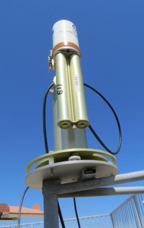
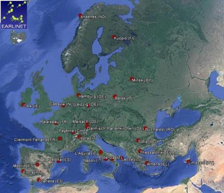
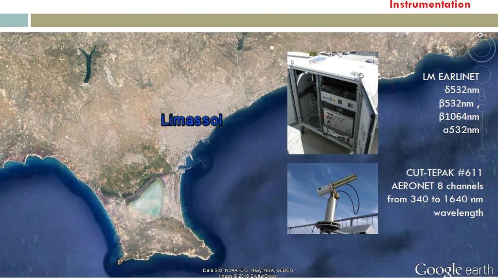
15 CUT-TEPAK AERONET ACTRIS Network CUT-TEPAK EARLINET LIDAR


16 Cypriot collaborations
 Cranfield University, (GB) University of Edinburgh, (GB) University of Sheffield, (GB) University of Pavia, (I) Delft University, (NE) Politechnico di Milano (IT) CNR (IT) Swiss Federal")
17 European collaborations >300 Universities & Research Centers Imperial College London, (GB) University of Surrey, (GB) University College London, (GB) Southampton University, (GB) Aberdeen University, (GB) Cranfield University, (GB) University of Edinburgh, (GB) University of Sheffield, (GB) University of Pavia, (I) Delft University, (NE) Politechnico di Milano (IT) CNR (IT) Swiss Federal Institute of Technology (ETH), (CH) Norwegian University of Science and Technology, (NO) Instituto Superior Technico, (P) University of Porto, (P) Aalborg University, (DK) Aristotle University of Thessaloniki, (GR) National Technical University of Athens, (GR) National Observatory of Athens, (GR) Federal Institute of Material Research and Testing, (DE) Swiss Federal Laboratories for Materials Testing and Research for Ιndustry, (CH) Ecole Nationale Supérieure des Télécommunications, (FR) TROPOS Institute (DE)

18 Beyond Europe collaborations USA Colorado School of Mines Harvard University University of Colorado Stanford University Georgia Tech Lehigh University University of Buffalo California State University Australia Newcastle University of Australia, Australia University of Western Australia, Australia Queensland University, Australia Asia Tokyo University, Japan Kyoto University, Japan Kansai University, Japan University of Osaka City, Japan Chinese Academy of Sciences, China Hong Kong Polytechnic University, HK University of Malaysia-Sabah

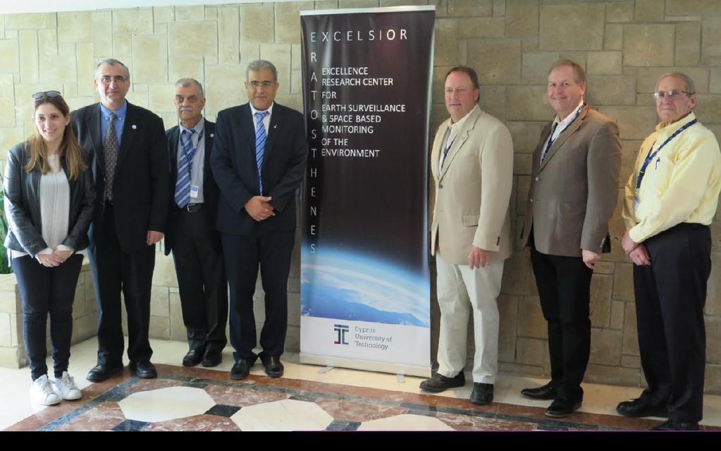
 EXCELSIOR Kick off meeting, 7-8 September 2017,")
19 Funding Participation to more than 60 projects from since 2007 Coordination of more than 20 funded research projects Research 30 active researchers coming form different backgrounds such as engineers; physics; earth scientist; chemists, surveying engineers, geologists, archaeologists etc working in 6 different thematic research areas of the Lab Provide 120 job positions since 2007 More than 100 dissertations/ final year projects Phd Supervision (more than 15 since 2007) EXCELSIOR Kick off meeting, 7-8 September 2017, Limassol, Cyprus


20 The Group has received funding for over 60 Competitive Research Programs since Cyprus Research Promotion Foundation 2. European Union 3. Industry
21 Applications / Activities / Funded Projects Archaeology /Cultural Heritage Marine Spatial Planning Water Resources Management Irrigation Demand / Agriculture Water Quality monitoring Forestry Air Pollution Climate Changes Aerosol Typing Aerosol/Cloud interaction Transport Crisis Management Bathymetry Positioning Navigation Animal Tracking Real Estate Utilities Mapping Infrastructure Education Navigation Water leakages monitoring Natural Hazards (Floods, earthquakes, fires etc) Disaster Management Defense & Security Tourism Landslides Safety of Life.selected projects 21 EARSEL FOREST FIRES SIG WORKSHOP, CHANIA 25/9/2017

22 FORESTRY (Mapping, Signatures) Landsat 8, 24 Ιουλίου 2016 / SOLEAS CYPRUS AOI 16,02 sq. km2


23 Mapping of burned areas in Solea using Sentinel-2 28/6/ sq.km2 (7-5-3)


24 smart buoy WATER: Water quality monitoring monitoring in inland waters (dams) Synoptic coverage and continuous monitoring of coastal waters to detect at any time any pollution event achieving in the immediate and sustainable management of water resources Data collected from the smart buoy was used for furthermore calibration of the retrieved algorithm due to high frequency of measurements collected.


25 LAND: Irrigation demand - Agriculture Integration of: Spectroscopy Micro-sensor technology Remote sensing Satellite imagery: retrieval of surface reflectance/temperature Spectroradiometric measurements: retrieval of ground reflectance Micro-sensors: soil moisture, temperature, RH etc. Irrigation models


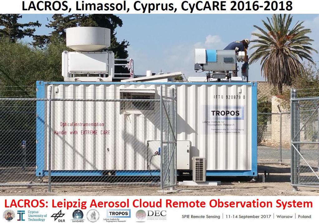
26 Air: Aerosol-Cloud Interaction Cy-CARE campaign BACCHUS project ACTRIS-CLOUDNET Training School, March 2017, Limassol
, Technical University of Crete, National Observatory of Athens, Cyprus Meteorological Service, Water")
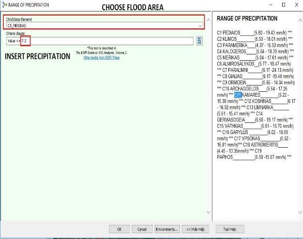
27 Risk analysis: Flood risk Integrated Use Of Satellite Remote Sensing And Hydraulic Modeling For The Flood Risk Assessment At A Catchment Scale In Cyprus Funding (200, 000 euros), Cyprus Research Promotion Foundation, Structural Funds Partners: Cyprus University of Technology (Coordinators), Technical University of Crete, National Observatory of Athens, Cyprus Meteorological Service, Water Development Department


28 Marine Spatial Planning (MSP) (blue growth) Main aim of the project is the joint development methodology, process and suitable implementation framework for Marine Spatial Planning Consortium: DEPARTMENT OF MERCHANT SHIPPING, DEPARTMENT OF LANDS AND SURVEYS, UNIVERSITY OF THE AEGEAN, MINISTRY OF MARINE AND AEGEAN, CYPRUS UNIVERSITY TECHNOLOGY, OCEANOGRAPHY CENTRE

29 Urban heat Study the urban heat island effect in Cyprus based on both multi temporal satellite and meteorological data Funding Cyprus Research Promotion Foundation Partners: Meteorological Department, National Observatory of Athens


 Unexcavated")
30 Detection of un-excavated archaeological sites Earth observation for Cultural Heritage (detection, management, protection etc Our proposed equation from a GeoEye example (Ilis archaeological site in Greece) Detection of Unexcavated buried remains Fusion of RS data 30
 and Operational Resources (OR) Co-financed by the EU-Union Civil Protection Mechanism Project number:")
31 HAZARDS USE OF A GEOSPATIAL EARLY-WARNING DECISION SUPPORT SYSTEM TO PREPARE FOR DISASTERS OR PLAN FOR MULTIPLE HAZARDS: DECATASTROPHIZE The development of a geo-spatial early-warning decision support system that will be connected to Emergency Operation Centers (EOC) and Operational Resources (OR) Co-financed by the EU-Union Civil Protection Mechanism Project number: ECHO/SUB/2015/713788/PREP


32 Static fire models (Creation of maps) Dynamic flood model

33 DECAT software: It is made up of three emergency management phase: 1. Early warning 2. Impact assessment 3. Emergency management mitigation of impact End user of the software: Cyprus Civil Defence


34 The Group has strong expertise in Atmospheric correction methods: Development & assessment c m. ts tg at-satellite reflectance atmospheric path radiance ground reflectance 34


35 EU opportunities for widening EXCELLENCE Widening consists of three main actions, i.e. Teaming, Twinning and ERA Chairs. ERA Chairs stands for excellence to institution. Outstanding academics, with proven research excellence and management skills, with potential for research excellence. Twinning stands for institutional networking. Transfer of Knowledge Teaming means institution building. Teaming projects create new or update existing centres of excellence in Widening countries through a coupling process with a leading scientific institution. EARSEL FOREST FIRES SIG WORKSHOP, CHANIA 25/9/2017


 The Centre aims to be in close")


36 The Group is coordinating a Twinning project: Remote Sensing Archaeology Centre of Excellence - ATHENA ATHENA: a funded project under the H2020- TWINN-2015 (www. athena2020.eu) The Centre aims to be in close collaboration with both national as well international research institutes and stakeholders, providing integrated remote sensing services and solutions in the area of the Eastern Mediterranean. The new perspectives on archaeological and cultural heritage in the region will position ATHENA as a centre of knowledge and a standard lab in the field of Remote Sensing Archaeology. EARSEL FOREST FIRES SIG WORKSHOP, CHANIA 25/9/2017


37 And now..the teaming project The pathway towards to a Centre of Excellence EARSEL FOREST FIRES SIG WORKSHOP, CHANIA 25/9/2017

38 EXCELSIOR s Structure: WPs EARSEL FOREST FIRES SIG WORKSHOP, CHANIA 25/9/2017


, can assist in a more sustainable and systematic monitoring of areas of interest and the on-time detection of risks,")
39 ERATOSTHENES The existing Remote Sensing & Geo-Environment Group (Eratosthenes), being the only established laboratory in Cyprus for space-based earth observation, possesses significant experience on Earth Observation, Remote Sensing, as well as sophisticated instruments and models that are needed to systematically observe, understand, protect, monitor and predict environmental parameters in land, water and air. EXCELSIOR DLR will support the planning and establish a satellite receiving station including attached processing and archiving functions with the possibility of a direct data flow into EO-based services and networks. NOA will seek to establish sustainable links between ERATOSTHENES CoE, and the BEYOND Centre of Excellence, that is established in the European Research Area as a regional Copernicus node for EO-based monitoring. TROPOS will be the key partner for the establishment of a ground based Remote Sensing station in ERATOSTHENES CoE, providing the close links between European networks and satellite validation activities. DEC-MTCW will provide the links to the local and governmental community and promote the space issues on the national level Added value The integration of novel technologies in the areas of Remote Sensing and space-based earth observation techniques, along with the use of Geographic Information Systems (GIS), can assist in a more sustainable and systematic monitoring of areas of interest and the on-time detection of risks, with the ultimate goal to protect the environment, providing critical information, through end user products, not only to policy makers and other local, national and regional authorities but also to citizens and tourists. EARSEL FOREST FIRES SIG WORKSHOP, CHANIA 25/9/2017
40 Why Space technologies? Research, Products and Services generated by Space technologies has the capacity to mobilise R&I and development and to boost the economies not only in Cyprus but in the entire Middle East region. The satellite data requires processing and, more importantly, fine-tuning towards the needs of the local users and their specific context in all branches of environmental monitoring, including climate change and emergency management. The Centre of Excellence will provide added value both in Cyprus and in Europe by strategically positioning itself as a leader in space industry services in the region as a result of its focus on remote sensing, Earth observation and satellites technologies, its advancements in environmental science and through its alignment with the Smart Specialization Strategy of Cyprus (S3Cy). EARSEL FOREST FIRES SIG WORKSHOP, CHANIA 25/9/2017


41 S3Cy In relation to the Copernicus trend, which provides products and services on Land, Marine and Atmosphere monitoring as well as on Emergency management, Security and Climate Change, ERATOSTHENES CoE is organized in 3 main research thematic areas, i.e. Land, Water and Air. (Natural Hazards, Agriculture, Forestry, Water Resources, Energy etc) NATURAL & BUILT ENVIRONMENT These three thematic Research Areas of the CoE embrace all six Copernicus services and interact with the priorities of S3Cy EARSEL FOREST FIRES SIG WORKSHOP, CHANIA 25/9/2017

42 why Cyprus? Cyprus s unique geostrategic position can support Earth Observation from satellites programmes in three continents and provide valuable services in the satellite calibration and validation processes. The ERATOSTHENES CoE with its expertise and infrastructure (e.g., prospectively its own satellite receiving stations and a state of the art ground based remote sensing station) - could further complete the existing network of international ground stations. The EXCELSIOR s vision and the geostrategic position of Cyprus EARSEL FOREST FIRES SIG WORKSHOP, CHANIA 25/9/2017
43 The priorities of the Centre of Excellence The Horizontal Priorities of the ERATOSTHENES CoE are: to promote Sustainable Development, based on exploitation of natural resources in respect and safeguard of the environment; to extend innovation in the field of Satellite Remote Sensing techniques and their integration with other geo-spatial data; to promote and enhance use of ICT-based tools and services oriented towards monitoring and protection of the environment (including air, land and water domain). The Vertical Priorities of the ERATOSTHENES CoE are: to promote knowledge on general benefits deriving from space-based products and services for non-space sectors; to experiment and promote basic and applied research in domain of remote sensing technologies for the benefits of environment monitoring; to optimize the citizens experience in terms of everyday space-based ICT systematic services and applications. EARSEL FOREST FIRES SIG WORKSHOP, CHANIA 25/9/2017


44 Pillars Innovation Research Services Products Education Culture EARSEL FOREST FIRES SIG WORKSHOP, CHANIA 25/9/2017
45 Expected impact on National economy and society Provide new job opportunities for highly educated researchers in Cyprus Establish new Departments of the Centre that will improve and expand current research capabilities Foster mobility among researchers (towards and from the Centre) with other universities, research centre and private sector Strengthen the relationship with industrial sector through specific agreements with local SMEs in EO domain regarding research exchange, collaboration on patents and creation of spin-offs Develop and disseminate integration tools to fully exploit the use of multiple remote sensing techniques at ground-based stations, in particular for the calibration/validation/integration of satellite sensors Maintain and enhance capacity of training in the field of EO particularly directed to new users including those from non-eu developing countries EARSEL FOREST FIRES SIG WORKSHOP, CHANIA 25/9/2017
46 The way The upgrading of the existing ERC into a CoE will be accomplished through a close interaction with a selection of the key partners (DLR, NOA, TROPOS) by taking advantage of their excellence in the topics addressed by the project. There is a strong collaboration between the partners for the last 5 to 10 years. EXCELSIOR will take full advantage of such partnerships with EU-leaders already well founded on their proven efficient collaboration through existing long standing partnerships in other EU funded and ESFRI projects. Networking, combined with experience in proposal preparation/ coordination, and strong links as well as deep engagement of different stakeholders, is the key for continuous funding attraction and maintenance and enhancement of capacities. EARSEL FOREST FIRES SIG WORKSHOP, CHANIA 25/9/2017

47 Partners contribution EARSEL FOREST FIRES SIG WORKSHOP, CHANIA 25/9/2017

48 Supporters of Phase 1 EXCELSIOR project EARSEL FOREST FIRES SIG WORKSHOP, CHANIA 25/9/2017


49 Together with the strategic location, the national infrastructure and expertise, we can develop innovative space technology services and attract investments. The Εarth observation sector in Cyprus is one of our priorities.. Minsister of Transport, Communications and Works at the kick off meeting 8 Sept 2017
50 Proposed HUB: for data, products, services Part of the business plan. Ground receiving station in Cyprus. Infrastructure for hub (design, plan, implement). Provide R &D, services in the Eastern Mediterranean and Middle East (EMME) and Middle East and North Africa (MENA).

 Associate Program Manager NASA Applied Sciences Program California State University Dr.")
51 An External Advisory Committee have been set up to guarantee and monitor the scientific quality of EXCELSIOR project. The Committee is composed of leading scientists in the field of Space-Based and Earth Observation technologies. Bearing in mind the scope of the EXCELSIOR project, every effort has been made to have in this EAC representatives from the areas of academia, business and science. Name Position Organisation Dr. Vincent Ambrosia (M) Associate Program Manager NASA Applied Sciences Program California State University Dr. Marcello Maranesi (M) International business experience in Geo-Spatial Information and Earth Observation independent consultant Prof. Lena Halounová (F) Head of the Remote Sensing Laboratory/ IPSRS Secretary General Czech Technical University Dr. Peter Zeil (M) Senior expert in the field of EO services and applications Spatial Services Gmbh Dr. Simonetta Cheli (F) Head of Coordination Office ESA Headquarters EARSEL FOREST FIRES SIG WORKSHOP, CHANIA 25/9/2017
52 VISION The new Centre to be the top-leading one in the Eastern-Med region in the earth observation Strong collaboration with partners/ organizations/agencies in the Eastern Mediterranean and Middle East (EMME) and Middle East and North Africa (MENA). To host top scientists in earth observation. To be a sustainable centre through European and national funds To provide product and services / Hub Cyprus to be on the European Map of Earth Observation Establishment of respective research infrastructure in Cyprus could further complete the existing network of international ground stations EARSEL FOREST FIRES SIG WORKSHOP, CHANIA 25/9/2017
53 Next Step develop a business plan for promoting further the existing Group to a EXcellence Research Centre for Earth SurveiLlance and Space-Based MonItoring Of the EnviRonment. The business plan will be submitted for evaluation to the EU Horizon 2020 framework for Research and Innovation during Phase 2 of the Teaming Programme, seeking funding of 15 million euros for a period of 5-7 years, with the possibility of an additional equal amount of national co-funding for a period of 15 years plus 4 millions from CUT= 35 MILLION EUROS consortium
54 Join us at this phase (through memorandum of unde Letters of commitment) Think for collaboration in earth observation in natural and built environment hazards, water resources, agriculture, coastal, cultural heritage, land applications, atmosphere, climate changes etc Think for future collaboration in the EASTERN MED REGION such as ENERGY (solar radiation, oil & gas etc)! This is one of the future activities of the upgraded centre
55 ATMOSPHERE: Why EAST MED? Why Cyprus
56
57 WATER RESOURCES MANAGEMENT Agriculture: Irrigation water management (image based techniques for evapotranspiration +field spectroscopy): GREAT OPPORTUNITIES IN THE EAST MED!

58 Remote Sensing Archaeology, Citation based research from : STILL A LOT TO BE DONE! 58

59 Announcement of H2020 Teaming results by EC


60 RSCy2018 SPIE PAFOS CYPRUS (26-29 March 2018)


61 Thank you for your attention For more information you can visit: Horizon 2020 Widespread : Teaming Phase 1 Coordination and support action Grant agreement no: Proposal acronym: EXCELSIOR info@excelsior2020.eu Excelsior2020 Excelsior 2020 Excelsior 2020
Earth Observation and GEOSS in Horizon Copernicus for Raw Material Workshop 5 th September 2016
 Earth Observation and GEOSS in Horizon 2020 Copernicus for Raw Material Workshop 5 th September 2016 Gilles OLLIER Head of Sector -Earth observation Directorate Environment Unit I.4 Climate Actions and
UN-GGIM: Strengthening Geospatial Capability
 Fifth Plenary Meeting of UN-GGIM: Europe Brussels, 6-7 June 2018 UN-GGIM: Strengthening Geospatial Capability Walking the talk to leave no one behind Greg Scott, UN-GGIM Secretariat Environmental Statistics
XXIII CONGRESS OF ISPRS RESOLUTIONS
 XXIII CONGRESS OF ISPRS RESOLUTIONS General Resolutions Resolution 0: Thanks to the Czech Society commends: To congratulate The Czech Society, its president and the Congress Director Lena Halounová, the
>
 Integrated use of remote sensing and Lidar techniques for the study of air pollution and optical properties of the atmosphere in Cyprus > http://cyprusremotesensing.com/ilatic/ > The project ILATIC "Integrated
Advancing Geoscientific Capability. Geological Survey of Finland
 Advancing Geoscientific Capability Geological Survey of Finland GTK in brief The Geological Survey of Finland (GTK) is one of the largest European centres of excellence in assessment, research and the
16540/14 EE/cm 1 DG E 1A
 Council of the European Union Brussels, 5 December 2014 (OR. en) 16540/14 ENV 965 CULT 139 NOTE From: To: Subject: General Secretariat of the Council Delegations Charter of Rome on Natural and Cultural
Plan4all (econtentplus project)
") Plan4all (econtentplus project) Karel CHARVAT 1, Tomáš MILDORF 2 1 Help service remote sensing, Ltd., Černoleská 1600, 256 01 Benešov u Prahy, Czech Republic charvat@bnhelp.cz 2 Department of Mathematics
Plan4all (econtentplus project) Karel CHARVAT 1, Tomáš MILDORF 2 1 Help service remote sensing, Ltd., Černoleská 1600, 256 01 Benešov u Prahy, Czech Republic charvat@bnhelp.cz 2 Department of Mathematics
Jordan's Strategic Research Agenda in cultural heritage
 Jordan's Strategic Research Agenda in cultural heritage Analysis of main results Alessandra Gandini Amman, Jordan 3 rd November 2013 Main objectives The work performed had the main objective of giving
EU collaborations with NASA LCLUC Program & Current Priorities
 & Current Priorities ioannis Manakos, Dr. Centre for Research and Technology Hellas Information Technologies Institute Visual Analytics, Virtual & Augmented Reality Laboratory European Association of Remote
Pilot applications for Greece and Egypt related end-users
 GEO-CRADLE Project Meeting 2 16 th November, 2016 Pilot applications for Greece and Egypt related end-users Panagiotis Kosmopoulos & Hesham El-Askary National Observatory of Athens Chapman University Eratosthenes
Observation (EO) & Geomatics in Canada
 & Geomatics in Canada") Innovating to Increase the Impact of Earth Observation (EO) & Geomatics in Canada Natural Resources Canada February 25, 2014 Prashant Shukle, Director General Canada Centre for Mapping and Earth Observation
Innovating to Increase the Impact of Earth Observation (EO) & Geomatics in Canada Natural Resources Canada February 25, 2014 Prashant Shukle, Director General Canada Centre for Mapping and Earth Observation
The ESPON Programme. Goals Main Results Future
 The ESPON Programme Goals Main Results Future Structure 1. Goals Objectives and expectations Participation, organisation and networking Themes addressed in the applied research undertaken in ESPON projects
sentinel-2 COLOUR VISION FOR COPERNICUS
 sentinel-2 COLOUR VISION FOR COPERNICUS SATELLITES TO SERVE By providing a set of key information services for a wide range of practical applications, Europe s Copernicus programme is providing a step
Dr Ozlem Adiyaman Earth Sciences and Geo-hazards Risk Reduction Section Division of Ecological and Earth Sciences ( ) NATURAL SCIENCES
 NATURAL SCIENCES") Earth Sciences and Geo-hazards Risk Reduction Section Earth observation with COPERNICUS to : protect, monitor, document, present and share our common heritage, our cultural and natural UNESCO World Heritage
Earth Sciences and Geo-hazards Risk Reduction Section Earth observation with COPERNICUS to : protect, monitor, document, present and share our common heritage, our cultural and natural UNESCO World Heritage
Excel Geomatics: Offering Excellence with Unique Consultancy & Services
 Excel Geomatics: Offering Excellence with Unique Consultancy & Services Providing consultancy and value Added Services using Remote Sensing, Photogrammetry and LiDAR in areas such as Agriculture, Forestry,
European Space Agency
 Guidelines - Guidelines how/when to interact during the WebEx session: - Due to the number of attendees, please keep always your webcam and microphone switched-off - You can use anytime the chat to all
Historical background
 Space Technology for Disaster Management in Sri Lanka: Country profile, national perspectives & vision. Professor Ranjith Premalal De Silva Vice Chancellor Uva Wellassa University of Sri Lanka October
UN GGIM and National SDI Strategy
 MSDI Open Forum on 26 th January 2016 Contributing to the successful delivery of MSDI UN GGIM and National SDI Strategy Hiroshi Murakami Deputy Administrator Geospatial Information Authority of Japan Geospatial
EO Information Services. Assessing Vulnerability in the metropolitan area of Rio de Janeiro (Floods & Landslides) Project
 Project") EO Information Services in support of Assessing Vulnerability in the metropolitan area of Rio de Janeiro (Floods & Landslides) Project Ricardo Armas, Critical Software SA Haris Kontoes, ISARS NOA World
EO Information Services in support of Assessing Vulnerability in the metropolitan area of Rio de Janeiro (Floods & Landslides) Project Ricardo Armas, Critical Software SA Haris Kontoes, ISARS NOA World
Land Use in the context of sustainable, smart and inclusive growth
 Land Use in the context of sustainable, smart and inclusive growth François Salgé Ministry of sustainable development France facilitator EUROGI vice president AFIGéO board member 1 Introduction e-content+
Mediterranean Sea and Territorial Development, Opportunities and Risks
 EESC Hearing Towards an EU Macro-Regional Strategy for the Mediterranean Mediterranean Sea and Territorial Development, Opportunities and Risks Michaela Gensheimer Structure of Intervention Part I: What
KUNMING FORUM ON UNITED NATIONS GLOBAL GEOSPATIAL INFORMATION MANAGEMENT CITIES OF THE FUTURE: SMART, RESILIENT
 KUNMING FORUM ON UNITED NATIONS GLOBAL GEOSPATIAL INFORMATION MANAGEMENT CITIES OF THE FUTURE: SMART, RESILIENT and SUSTAINABLE Yunnan Zhenzhuang Guest House, Kunming, China 10 12 May 2017 BACKGROUND CONCEPT
Supporting GPSC Cities with Satellite Earth Observation for Sustainable Urban Development
 Supporting GPSC Cities with Satellite Earth Observation for Sustainable Urban Development Global Platform for Sustainable Cities African Regional Workshop 14 May 2018 AfDB Headquarters Abidjan, Côte d'ivoire
Remote Sensing and EO activities at the University of Turku
 Remote Sensing and EO activities at the University of Turku Niina Käyhkö Associate Professor Department of Geography and Geology GEO meeting/syke May 23rd, 2018 Geospatial competence at the University
Aboriginal communities strengthen governance with location-based tools in the 21st century
 Aboriginal communities strengthen governance with location-based tools in the 21st century Today, Aboriginal communities are taking advantage of the geomatics technologies that underpin popular online
ASEV - Partner presentation
 ASEV - Partner presentation Lorenzo Sabatini Head of RTD project area l.sabatini@asev.it 20th-21st February, 2017 Kickoff meeting - Porto About ASEV ASEV - Agenzia per lo Sviluppo Empolese Valdelsa Spa
Update to the Association of Ontario Land Surveyors February 27, 2015 Deerhurst, Ontario
 1 Update to the Association of Ontario Land Surveyors February 27, 2015 Deerhurst, Ontario Peter Sullivan CLS, ALS, MBA Director General, Surveyor General Branch Earth Sciences Sector, Natural Resources
REGIONAL SDI DEVELOPMENT
 REGIONAL SDI DEVELOPMENT Abbas Rajabifard 1 and Ian P. Williamson 2 1 Deputy Director and Senior Research Fellow Email: abbas.r@unimelb.edu.au 2 Director, Professor of Surveying and Land Information, Email:
Open data integration: from satellite to UAV for protection of built environment. The archaeological site in the Centa River bed in Albenga
 Open data integration: from satellite to UAV for protection of built environment. The archaeological site in the Centa River bed in Albenga L. Barazzetti a, R. Brumana a, B. Cuca a,b, M. Previtali a, R.
Briefing. H.E. Mr. Gyan Chandra Acharya
 Briefing by H.E. Mr. Gyan Chandra Acharya Under-Secretary-General and High Representative for the Least Developed Countries, Landlocked Developing Countries and Small Island Developing States Briefing
PART A Project summary
 PART A Project summary A.1 Project identification Project title Project acronym Name of the lead partner organisation in English Specific objective Demonstrattion AF DAF Partner 1.1. Improving innovation
2018/1 The integration of statistical and geospatial information. The Regional Committee of UN-GGIM: Americas:
 The following are the conclusions and recommendations of the Regional Committee of the United Nations on Global Geospatial Information Management for the Americas, during its Fifth Session, Thursday 8
AND THE COOPERATION WITH SENTINEL ASIA FOR DISASTER MANAGEMENT
 Ministry of Natural resources and Environment National Remote Sensing DEpartment NATIONAL REMOTE SENSING DEPARTMENT (NRSD) AND THE COOPERATION WITH SENTINEL ASIA FOR DISASTER MANAGEMENT By: Dr. Chu Hai
Space research. Horizon Work Programme. "Countdown to Horizon 2020 Space" Earth Observation topics. Brussels, 12 December 2013
 Space research Horizon 2020 - Work Programme "Countdown to Horizon 2020 Space" Earth Observation topics Brussels, 12 December 2013 richard.gilmore@ec.europa.eu Table of contents FP/Copernicus - general
Spatially enabling e-government through geo-services
 Spatially enabling e-government through geo-services Mauro Salvemini EUROGI PRESIDENT Professor at Sapienza Università di Roma (IT) 1 About the presentation Few information about Eurogi ; Some essential
Challenges and Successes in Sharing Geospatial Data in Africa
 Challenges and Successes in Sharing Geospatial Data in Africa 2018 GeoNode Summit Torino, Italy March 26-28, 2018 Bernard Justus Muhwezi Manager, Geo-Information Services Uganda Bureau of Statistics, Kampala,
THE ROLE OF GEOSPATIAL AT THE WORLD BANK
 THE ROLE OF GEOSPATIAL AT THE WORLD BANK INSPIRE Conference Barcelona, Spain September 26, 2016 Kathrine Kelm Senior Land Administration Specialist Global Land and Geospatial Unit The World Bank Group
Copernicus Academy. Roles and responsibilities of the Copernicus Academy. user uptake. Focus Data uptake, capacity building and skills development
 Copernicus Academy user uptake Roles and responsibilities of the Copernicus Academy The European Commission has launched two Networks, the Copernicus Relays and the Copernicus Academy, to contribute on
Esri and GIS Education
 Esri and GIS Education Organizations Esri Users 1,200 National Government Agencies 11,500 States & Regional Agencies 30,800 Cities & Local Governments 32,000 Businesses 8,500 Utilities 12,600 NGOs 11,000
Geographic Information Infrastructure and Policy Framework for Sustainable Mountain Development in the Hindu Kush-Himalayas
 Geo SMART ASIA 2017 22-24 August, Kualalampur Geographic Information Infrastructure and Policy Framework for Sustainable Mountain Development in the Hindu Kush-Himalayas Basanta Shrestha, Director Strategic
The National Spatial Strategy
 Purpose of this Consultation Paper This paper seeks the views of a wide range of bodies, interests and members of the public on the issues which the National Spatial Strategy should address. These views
Implementation of the ESPON 2020 cooperation program. 16 January 2017 Anneloes van Noordt
 Implementation of the ESPON 2020 cooperation program 16 January 2017 Anneloes van Noordt Outline! ESPON Cooperation Program! Specific Objectives! Applied Research! Targeted Analysis! Database & Tools!
Geodesy. orientation. shape. gravity field
 Geodesy noun Science of measuring the shape, orientation and gravity field of the Earth and how it changes over time. shape orientation gravity field Positioning has always been important Downstream applications
Themes for Geomatics Conference. Geodesy Themes
 Themes for Geomatics Conference Geodesy Themes Geodynamics o Modeling the Deformation of the Earth s Crust o Recent Advances in Geometric Approaches to Deformation Analysis o Monitoring Systems (Sensors
CONFERENCE STATEMENT
 CONFERENCE STATEMENT We, the elected representatives from Canada, Denmark/Greenland, Finland, Iceland, Norway, Russia, Sweden and the United States of America; In collaboration with the indigenous peoples
Oman NSDI Business Values and Future Directions. Hassan Alawi Alghazali Acting Director General National Spatial Data Infrastructure
 Oman NSDI Business Values and Future Directions Hassan Alawi Alghazali Acting Director General National Spatial Data Infrastructure Presentation Outline Geospatial Maturity Current Challenges NCSI s Role
Urbanization and Sustainable Development of Cities: A Ready Engine to Promote Economic Growth and Cooperation
 Urbanization and Sustainable Development of Cities: A Ready Engine to Promote Economic Growth and Cooperation Wan Portia Hamzah Institute of Strategic and International Studies (ISIS) Malaysia 10 September
National Remote Sensing Center of China. Space Technology for Sustainable Development in China Status, Achievements and Futures.
 National Remote Sensing Center of China Space Technology for Sustainable Development in China Status, Achievements and Futures Jing Li National Remote Sensing Center of China Ministry of Science and Technology,
A Broad View of Geospatial Technology & Systems
 A Broad View of Geospatial Technology & Systems Pete Large Vice President, Trimble On the shoulders of giants 1 Since their time, our ability to generate geospatial information has grown exponentially
Statewide Topographic Mapping Program
 Statewide Topographic Mapping Program February 28, 2018 www.dotd.la.gov Outline Purpose of the Statewide Topographic Mapping Program History Breakdown of R.S. 48:36 - Topographic Mapping Statewide Topographic
The Joint Programming Initiative on Cultural Heritage (JPICH): European perspective
: European perspective") COPERNICUS FOR CULTURAL HERITAGE Copernicus User Forum Industry Workshop Brussels, 24 April 2017 The Joint Programming Initiative on Cultural Heritage (JPICH): European perspective Cristina Sabbioni CNR,
COPERNICUS FOR CULTURAL HERITAGE Copernicus User Forum Industry Workshop Brussels, 24 April 2017 The Joint Programming Initiative on Cultural Heritage (JPICH): European perspective Cristina Sabbioni CNR,
Urban areas & climate change
 Urban areas & climate change Paolo Gamba University of Pavia University of Pavia The UNIPV TLC & RS Lab is a dynamic research group developing in the past years many techniques devoted to the analysis
FINDINGS OF THE ARCTIC METEOROLOGY SUMMIT
 FINDINGS OF THE ARCTIC METEOROLOGY SUMMIT 2018 WWW.FMI.FI CHAIR S SUMMARY: 1 2 3 We need to be curious to explore the known unknowns. Meteorology is an elemental part of international collaboration in
COUNCIL OF THE EUROPEAN UNION. Brussels, 2 May /14 CULT 68
 COUNCIL OF THE EUROPEAN UNION Brussels, 2 May 2014 9129/14 CULT 68 NOTE from: General Secretariat of the Council to: Permanent Representatives Committee (Part 1) / Council No. prev. doc.: 8892/14 CULT
SDG s and the role of Earth Observation
 SDG s and the role of Earth Observation Christian Heipke IPI - Institute for Photogrammetry and GeoInformation Leibniz Universität Hannover Germany Secretary General, ISPRS 1. No Poverty 2. Zero Hunger
Current experiences in the use of satellite information in development aid activities
 Current experiences in the use of satellite information in development aid activities Meeting at ESA/ESRIN in Frascati 16 th of September 2017 #WorldInCommon AGENCE FRANÇAISE DE DÉVELOPPEMENT FRENCH DEVELOPMENT
FINLAND, A COOL ARCTIC COUNTRY WITH SNOW-HOW
 FINLAND, A COOL ARCTIC COUNTRY WITH SNOW-HOW To succeed in a constantly changing world, you have to change as well. Finland has reinvented itself in just one short century and we re still at it. Our national
Economic and Social Council
 United Nations Economic and Social Council Distr.: General 18 July 2016 Original: English Committee of Experts on Global Geospatial Information Management Sixth session New York, 3-5 August 2016 Item 2
Global Monitoring for Environment and Security (GMES)
") Global Monitoring for Environment and Security (GMES) Satellite Earth Observation for the Emergency Services Dr Nick Veck Presentation to the G-STEP Launch Univ. of Leicester 19 th June 2009 Contents of
Global Monitoring for Environment and Security (GMES) Satellite Earth Observation for the Emergency Services Dr Nick Veck Presentation to the G-STEP Launch Univ. of Leicester 19 th June 2009 Contents of
Non-Governmental Organizations for Spatial Data Infrastructure. Environmental Democracy Case
 Non-Governmental Organizations for Spatial Data Infrastructure Environmental Democracy Case L.Jovičić, S.Vrečar, V.Cetl, K.Ristovski GSDI Small Grant Program Award 2011-2012 Non-Governmental Organisations
EuroGEOSS Protected Areas Pilot
 EuroGEOSS Protected Areas Pilot Max Craglia European Commission Joint Research Centre Part 1: the present MyNatura2000 Mobile app. Awareness raising & volunteered data collection. Natura2000 covers 18%
Egypt-NOAA Cooperation: Advancing our Environmental Science, Technology, and Education
 Egypt-NOAA Cooperation: Advancing our Environmental Science, Technology, and Education T. G. Onsager NOAA Space Weather Prediction Center and NWS International Activities Office (one-year detail) Terry.Onsager@noaa.gov
EXPERT ANALYSIS ON GEOGRAPHICAL SPECIFICITIES
 EXPERT ANALYSIS ON GEOGRAPHICAL SPECIFICITIES Mountains, Islands and Sparsely Populated Areas Dr. Gilda Carbone 9 Oct 2018 Objectives: to gather basic information from relevant programming documents (PAs,
Poland, European Territory, ESPON Programme Warsaw, 2 July 2007 STRATEGY OF THE ESPON 2013 PROGRAMME
 Poland, European Territory, ESPON Programme 2007-2013 Warsaw, 2 July 2007 STRATEGY OF THE ESPON 2013 PROGRAMME Territory matters Regional diversity as asset Territorial potentials increasing in importance
EUSAIR on sea topics from Slovenian perspective
 MINISTRY OF FOREIGN AFFAIRS REPUBLIC OF SLOVENIA EUSAIR on sea topics from Slovenian perspective Mag. Andreja Jerina National Coordinator 4 EU MRS: 270 millions of population 19 MS 12 non MS Sea basin
Rising from the Depths Utilising Marine Cultural Heritage in East Africa to help develop sustainable social, economic and cultural benefits
 KENYA MEETING, 23 rd FEBRUARY 2018 1 Rising from the Depths Utilising Marine Cultural Heritage in East Africa to help develop sustainable social, economic and cultural benefits 1. Introduction The Rising
GEOMATICS. Shaping our world. A company of
 GEOMATICS Shaping our world A company of OUR EXPERTISE Geomatics Geomatics plays a mayor role in hydropower, land and water resources, urban development, transport & mobility, renewable energy, and infrastructure
Copernicus Today and Tomorrow GEO Week Group on Earth Observation Geneva, 16 January 2014 The Copernicus Space Infrastructure
 Copernicus Today and Tomorrow GEO Week Group on Earth Observation Geneva, 16 January 2014 The Copernicus Space Infrastructure Thomas Beer, Policy Coordinator, Copernicus Space Office, ESA-ESRIN, Frascati
WMO Public Weather Services: Enhanced Communication Skills for Improved Service Delivery. by S.W. Muchemi (WMO)
") WMO Public Weather Services: Enhanced Communication Skills for Improved Service Delivery by S.W. Muchemi (WMO) Functions of the Public Weather Services (PWS) programme of WMO To strengthen the capabilities
WMO Public Weather Services: Enhanced Communication Skills for Improved Service Delivery by S.W. Muchemi (WMO) Functions of the Public Weather Services (PWS) programme of WMO To strengthen the capabilities
Central Baltic Programme
 Central Baltic Programme 2014-2020 About the Central Baltic Programme 2014-2020 Builds on the Central Baltic INTERREG IV A Programme 2007-2013 Cross-border cooperation projects in the central Baltic Sea
Introduction of the Asia-Oceania Global Earth Observation System of Systems (AOGEOSS) GEO Initiative(GI-22 )
 GEO Initiative(GI-22 )") Introduction of the Asia-Oceania Global Earth Observation System of Systems (AOGEOSS) GEO Initiative(GI-22 ) Prof. Xiang ZHOU Institute of Remote Sensing and Digital Earth, CAS 11 May 2017 Kunming, China
Introduction of the Asia-Oceania Global Earth Observation System of Systems (AOGEOSS) GEO Initiative(GI-22 ) Prof. Xiang ZHOU Institute of Remote Sensing and Digital Earth, CAS 11 May 2017 Kunming, China
Building Institutional Capacity for Multi-Hazard Early Warning in Asia and the Pacific Subtitle
 Building Institutional Capacity for Multi-Hazard Early Warning in Asia and the Pacific Subtitle Title Keran Wang Chief, Space Applications Section ICT and Disaster Risk Reduction Division 22 May 2018 Pillar
Declaration Population and culture
 Declaration Population and culture The ministers of the parties to the Alpine Convention regard the socio-economic and socio-cultural aspects mentioned in Article 2, Paragraph 2, Item a., as being central
Strengthening the cooperation in the region: Carpathian, Tisa,, Danube and Black Sea areas
 Strengthening the cooperation in the region: Carpathian, Tisa,, Danube and Black Sea areas 14th October 2009 SEE Annual Conference Advancing development through transnational cooperation in South East
Exploring GIS Potential for Northwestern Ontario Land Information Ontario
 Exploring GIS Potential for Northwestern Ontario Land Information Ontario May 13, 2015 The LIO Vision LIO Vision: That all geographic information about Ontario is fully integrated and accessible LIO Goal:
Weather Climate Science to Service Partnership South Africa
 PROJECTS UNDERWAY Title of the Weather Climate Science to Service Partnership South Africa Together, building on an existing strong partnership, South African Weather Service and the Met Office will build
Implementing the Sustainable Development Goals: The Role of Geospatial Technology and Innovation
 Fifth High Level Forum on UN Global Geospatial Information Management Implementing the Sustainable Development Goals: The Role of Geospatial Technology and Innovation 28-30 November 2017 Sheraton Maria
Emergency Management Service (EMS) mapping
 mapping") GMES Emergency Management Service (EMS) mapping Frédéric BASTIDE GMES unit, European Commission UN-SPIDER Expert Meeting: "Crowdsource Mapping for Disaster Risk Management and Emergency Response" 3-5 December,
GMES Emergency Management Service (EMS) mapping Frédéric BASTIDE GMES unit, European Commission UN-SPIDER Expert Meeting: "Crowdsource Mapping for Disaster Risk Management and Emergency Response" 3-5 December,
The European territory: Strategic developmentd
 The European territory: Strategic developmentd Peter Mehlbye Workshop Strategic Development Catalonia 11 June 2002 THE LECTURE Structure I. Territorial trends II. Strategy for European spatial development
Roadmap to interoperability of geoinformation
 Roadmap to interoperability of geoinformation and services in Europe Paul Smits, Alessandro Annoni European Commission Joint Research Centre Institute for Environment and Sustainability paul.smits@jrc.it
SPATIAL STRATEGIES ON THE ISLAND OF IRELAND: FRAMEWORK FOR COLLABORATION
 SPATIAL STRATEGIES ON THE ISLAND OF IRELAND: FRAMEWORK FOR COLLABORATION THE PRACTICAL OPPORTUNITIES Mr. John Driscoll, Director, International Centre for Local and Regional Development Mr. Jim Hetherington,
WMO Guide on Integrated Urban Weather, Environment and Climate Services for Cities (IUWECS) Hong Kong- an experience from a high-density city
 Hong Kong- an experience from a high-density city") WMO Guide on Integrated Urban Weather, Environment and Climate Services for Cities (IUWECS) Hong Kong- an experience from a high-density city Dr. Chao REN Associate Professor School of Architecture The
WMO Guide on Integrated Urban Weather, Environment and Climate Services for Cities (IUWECS) Hong Kong- an experience from a high-density city Dr. Chao REN Associate Professor School of Architecture The
Georeferencing and Satellite Image Support: Lessons learned, Challenges and Opportunities
 Georeferencing and Satellite Image Support: Lessons learned, Challenges and Opportunities Shirish Ravan shirish.ravan@unoosa.org UN-SPIDER United Nations Office for Outer Space Affairs (UNOOSA) UN-SPIDER
Space Application in Support of Land Management for SDG Implementation
 Space Application in Support of Land Management for SDG Implementation Regional Expert Workshop on Land Accounting for SDG Monitoring and Reporting 26 September 2017 Space Application Section Information
Background Document: Report of the Regional Committee of United Nations Global Geospatial Information Management for Asia and the Pacific
 Background Document: Report of the Regional Committee of United Nations Global Geospatial Information Management for Asia and the Pacific 1. Summary 1. This report highlights the activities carried out
KENYA NATIONAL BUREAU OF STATISTICS Workshop on
 KENYA NATIONAL BUREAU OF STATISTICS Workshop on Capacity Building in Environment Statistics: the Framework for the Development of Environment Statistics (FDES 2013) Coordination with Sector Ministries
Space Applications for Disaster Risk Reduction and Sustainable Development
 Space Applications for Disaster Risk Reduction and Sustainable Development Space Applications Section (SAS) ICT and Disaster Risk Reduction Division (IDD) UNESCAP Contents I. RESAP Activities 2016-2017
Launch of the ESPON 2013 Programme. European observation network on territorial development and cohesion
 Launch of the ESPON 2013 Programme European observation network on territorial development and cohesion Framework conditions for the ESPON 2013 Programme Policy development in use of territorial evidence
The BEYOND Center of Excellence for monitoring natural disasters from space
 The BEYOND Center of Excellence for monitoring natural disasters from space Ioannis Papoutsis National Observatory of Athens Institute for Astronomy, Astrophysics, Space Applications & Remote Sensing MOWE-IT
Arctic Observing Systems Challenges, New opportunities and Integration
 Arctic Observing Systems Challenges, New opportunities and Integration Japan Norway Arctic Science Week 03 June 2016 By Stein Sandven, NERSC Building an integrated Arctic Observing System Need to collect,
Cutting Edge Engineering for Modern Geospatial Systems Rear Admiral Dr. S Kulshrestha, retd
 Cutting Edge Engineering for Modern Geospatial Systems Rear Admiral Dr. S Kulshrestha, retd 11 Jun 2015 GeoIntelligence Asia 2015 The technology would become so pervasive that it becomes a part of you
Economic Benefit Study on Value of Spatial Information Australian Experience
 Economic Benefit Study on Value of Spatial Information Australian Experience Dr Zaffar Sadiq Mohamed-Ghouse Director, International Relations Cooperative Research Centre for Spatial Information zsadiq@crcsi.com.au
The GMES/MyOcean Marine Service and its applications
 The GMES/MyOcean Marine Service and its applications P.Y. Le Traon (Ifremer) P. Bahurel (Mercator Ocean) First BreTel Workshop May 31st, 2012 - St Malo Outline The GMES Marine Service and MyOcean What
IAEG SDGs WG GI, , Mexico City
 IAEG SDGs WG GI, 12-14.12.2016, Mexico City UN-GGIM:Europe s perspective and activities to support better integration of geospatial information and statistics and the UN SDG monitoring Pier-Giorgio Zaccheddu,
Ministry of Health and Long-Term Care Geographic Information System (GIS) Strategy An Overview of the Strategy Implementation Plan November 2009
 Strategy An Overview of the Strategy Implementation Plan November 2009") Ministry of Health and Long-Term Care Geographic Information System (GIS) Strategy An Overview of the Strategy Implementation Plan November 2009 John Hill, Health Analytics Branch Health System Information
Ministry of Health and Long-Term Care Geographic Information System (GIS) Strategy An Overview of the Strategy Implementation Plan November 2009 John Hill, Health Analytics Branch Health System Information
Ministry of ICT of I.R.IRAN
 The ECO 8/6 mill km 2 10 Slamic countries ~330 mill people Oil, Gas, Industries,Tourism 2 Issue transformation in last decade Problem solving needs more integrated approach More interaction &complexity
Spanish national plan for land observation: new collaborative production system in Europe
 ADVANCE UNEDITED VERSION UNITED NATIONS E/CONF.103/5/Add.1 Economic and Social Affairs 9 July 2013 Tenth United Nations Regional Cartographic Conference for the Americas New York, 19-23, August 2013 Item
CONFERENCE STATEMENT
 Final draft CONFERENCE STATEMENT We, the elected representatives of Canada, Denmark/Greenland, the European Parliament, Finland, Iceland, Norway, Russia, Sweden and the United States of America; In collaboration
Faatasi Malologa (PGSC Chair) Director Department of Lands & Survey, Tuvalu
 Director Department of Lands & Survey, Tuvalu") Seventh Session of the United Nations Committee of Experts on Global Geospatial Information Management (UN-GGIM) - 31 July -4 August 2017 Faatasi Malologa (PGSC Chair) Director Department of Lands & Survey,
Seventh Session of the United Nations Committee of Experts on Global Geospatial Information Management (UN-GGIM) - 31 July -4 August 2017 Faatasi Malologa (PGSC Chair) Director Department of Lands & Survey,
THE USE OF GEOMATICS IN CULTURAL HERITAGE AND ARCHAEOLOGY FOR VARIOUS PURPOSES
 THE USE OF GEOMATICS IN CULTURAL HERITAGE AND ARCHAEOLOGY FOR VARIOUS PURPOSES FEBRUARY 2013 AL BEIDA GEOPLAN CONTENT Company Profile Concept Objectives and Strategies Data Production Methods Data Samples