Open data integration: from satellite to UAV for protection of built environment. The archaeological site in the Centa River bed in Albenga
|
|
|
- Debra Clementine Elliott
- 5 years ago
- Views:
Transcription
1 Open data integration: from satellite to UAV for protection of built environment. The archaeological site in the Centa River bed in Albenga L. Barazzetti a, R. Brumana a, B. Cuca a,b, M. Previtali a, R. Valente b a Politecnico di Milano, Department of Architecture, Built Environment and Construction Engineering, Via Ponzio 31, Milano, Italy b Cyprus University of Technology, Dept. of Civil Engineering and Geomatics, Saripolou str. 2-8, 3036 Limassol, Cyprus ADVANCES IN REMOTE SENSING FOR CULTURAL HERITAGE: FROM SITE DETECTION, TO DOCUMENTATION AND RISK MONITORING November 2015 ESA - ESRIN Frascati (Rome), Italy


2 Climate Change and World Heritage UNESCO reported several measures for a successful conservation and adaptation to change of cultural heritage: Preventive actions: monitoring, reporting and mitigation of climate change effects through environmentally sound choices and decisions at a range of levels: individual, community, institutional and corporate. Corrective actions: adaptation to the reality of climate change through global and regional strategies and local management plans. Sharing knowledge: including best practices, research, communication, public and political support, education and training, capacity building, networking, etc. Venice Sydney, Opera House Great Barrier Reef
-system Wider number of actors and competences are required GEO/GEOSS initiative The Gobal Earth Observation System of Systems Earth observation may")
 Earth Observations, Climate Change and")
3 When dealing with effects of climate change, it is more feasible and sustainable to think of heritage on a landscape scale and as a part of a larger (eco)-system Wider number of actors and competences are required GEO/GEOSS initiative The Gobal Earth Observation System of Systems Earth observation may help to: o illustrate the patterns of earth surface; o simulate past or future scenarios regarding larger portions of environment; o systematic monitoring of archaeological heritage; o new satellites with higher spectral and geometrical resolution (Copernicus/Sentinels) Earth Observations, Climate Change and World Heritage


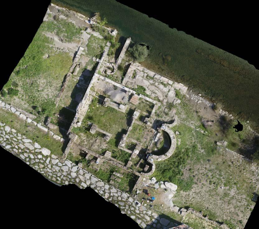
4 The Centa river archaeological site in Albenga The archaeological site in Albenga is a wide and highly stratified area located inside the riverbed of the Centa, the main river of the Ligurian settlement, south of the historic town ALBENGA The first relevant findings inside the Centa riverbed date back to , found during an artificial expansion of the right bank, when ancient structures and the funerary area of San Clemente were unveiled Archaeological Site
")

5 Ancient morphology of Albenga coast line (ante XIII century) Main roman communication way and archaeological area in the Centa River


6 Archaeological area in the Centa River bed Roman funerary structures Roman waterpipe Roman thermal buildings San Clemente church Postmedieval mill XIX th century bridge remains


7 Data source avallabile Several data sources are required to study the area: High and medium resolution satellite images Hydrological network of the Centa Basin Risk maps High resolution orthophoto with UAV On-site measurements Each one with its own protocols, data format, CRS, etc. How we can integrate them all together?


8 15 Partners 6 EU Countries SME Research Centers Universities ENERGIC OD has received funding from the European Union ICT Policy Support Programme (ICT PSP) under the Competitiveness and Innovation Framework Programme (CIP), grant agreement n
 as developed in GEO/GEOSS (the Global Earth Observation System of")
9 Virtual HUB (VH) brokering approach ENERGIC OD make use of the brokering approach (Discovery and Access Broker - DAB) and the architecture SoSs (System of Systems) as developed in GEO/GEOSS (the Global Earth Observation System of Systems)
10 Virtual HUB (VH) brokering approach ENERGIC OD make use of the brokering approach (Discovery and Access Broker - DAB) and the architecture SoSs (System of Systems) as developed in GEO/GEOSS (the Global Earth Observation System of Systems) A new mediation level is introduced to accomplish mediation of geospatial data In this way the broker interconnect heterogeneous data sources exposing a single interface

11 Virtual HUB (VH) brokering approach A new mediation level is introduced to accomplish mediation of geospatial data Task to be accomplished: Connect heterogeneous data sources Data discovery Semantic consistency Data access => Interoperability among data sources Data harmonization
12 Virtual HUB (VH) brokering approach Discovery: Identify sources of geospatial data Connect Data sources at different level Implementation of mainly used discovery services Discovery based on specific criteria: Keywords, temporal and spatial constraints, etc.
13 Virtual HUB (VH) brokering approach Semantic: Multilingualism Allow the search of similar words (rainfall-precipitation) Multi-User profiles Cluster data based on taxonomies/ ontologies 13

14 Virtual HUB (VH) brokering approach Access: Implementation of mainly used access services Implementation of mainly used data formats Allow an homogeneous access to a set of heterogeneous sources

15 Virtual HUB (VH) brokering approach Transform: Data homogenization in terms of data resolution and sampling CRS transformation by using a WPS


16 Data source integration Data sources integrated for the Centa River: Satellite imges Risk maps Hydrological networks UAV orthophoto On-site measurements Integrated data are accessible within an online platform built on top of a brokering architecture system


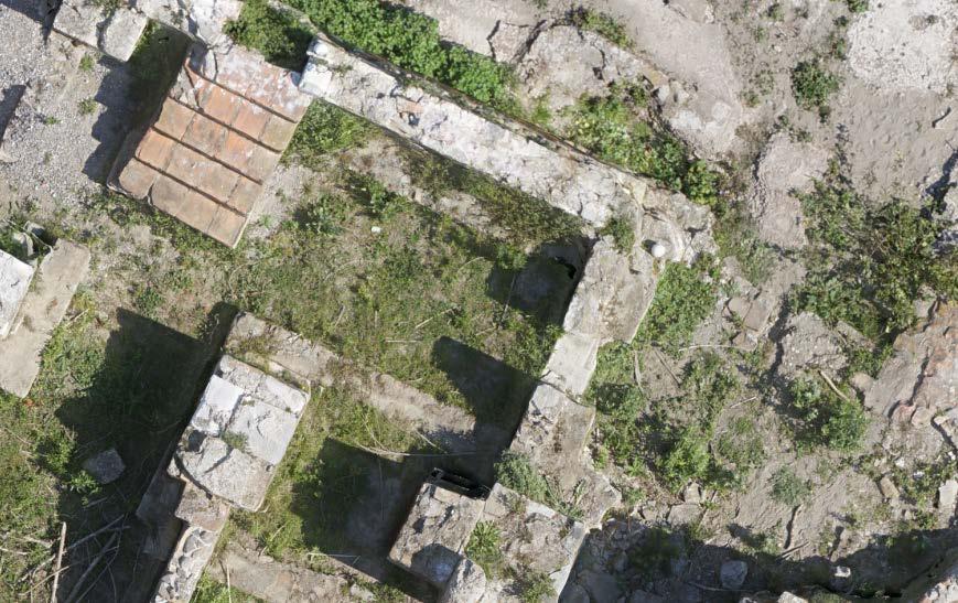
17 On site data Laser scans and total station data coupled with GNSS A drone AscTec Falcon 8 was then used for the production of high resolution orthophotos
18
19
20 Conclusions A new application for data retrieval based on the Virtual Hub brokering approach (GeoPan Atl@s) is at the fine-tuining stage by POLIMI The application was build upon the information deriving from different datasets, in particular those regarding high resolution satellite imagery, risk maps, hydrological maps but also historic cartography and terrestrial survey Geopan Atl@s allow a simplified approach for data search and collection, providing an efficient and innovative tool to both expert operators in the field of remote sensing, specialists in preservation and conservation policies, or other operators interested in monitoring, modelling and management of the environment and landscape in general The attempt of this experiment is to 1) stimulate a larger use of Open Data by both professional community and citizens and to 2) to contribute to a community based Web 2.0 by promoting an active engagement of participants in safeguard and maintenance of archaeo-landscapes, currently under the strong impact of the climate change effects.
21 THANK YOU! Open data integration: from satellite to UAV for protection of built environment. The archaeological site in the Centa River bed in Albenga L. Barazzetti a, R. Brumana a, B. Cuca a,b, M. Previtali a, R. Valente b a Politecnico di Milano, Department of Architecture, Built Environment and Construction Engineering, Via Ponzio 31, Milano, Italy b Cyprus University of Technology, Dept. of Civil Engineering and Geomatics, Saripolou str. 2-8, 3036 Limassol, Cyprus branka.cuca@polimi.it branka.cuca@cut.ac.cy
Jordan's Strategic Research Agenda in cultural heritage
 Jordan's Strategic Research Agenda in cultural heritage Analysis of main results Alessandra Gandini Amman, Jordan 3 rd November 2013 Main objectives The work performed had the main objective of giving
GEOMATICS. Shaping our world. A company of
 GEOMATICS Shaping our world A company of OUR EXPERTISE Geomatics Geomatics plays a mayor role in hydropower, land and water resources, urban development, transport & mobility, renewable energy, and infrastructure
Developing a Spatial Data Infrastructure for Cultural Heritage
 Developing a Spatial Data Infrastructure for Cultural Heritage Peter M c Keague (RCAHMS) Anthony Corns and Robert Shaw (Discovery Programme) Developing a Spatial Data Infrastructure for Cultural Heritage
Plan4all (econtentplus project)
") Plan4all (econtentplus project) Karel CHARVAT 1, Tomáš MILDORF 2 1 Help service remote sensing, Ltd., Černoleská 1600, 256 01 Benešov u Prahy, Czech Republic charvat@bnhelp.cz 2 Department of Mathematics
Plan4all (econtentplus project) Karel CHARVAT 1, Tomáš MILDORF 2 1 Help service remote sensing, Ltd., Černoleská 1600, 256 01 Benešov u Prahy, Czech Republic charvat@bnhelp.cz 2 Department of Mathematics
3D Urban Information Models in making a smart city the i-scope project case study
 UDC: 007:528.9]:004; 007:912]:004; 004.92 DOI: 10.14438/gn.2014.17 Typology: 1.04 Professional Article 3D Urban Information Models in making a smart city the i-scope project case study Dragutin PROTIĆ
Declaration Population and culture
 Declaration Population and culture The ministers of the parties to the Alpine Convention regard the socio-economic and socio-cultural aspects mentioned in Article 2, Paragraph 2, Item a., as being central
XXIII CONGRESS OF ISPRS RESOLUTIONS
 XXIII CONGRESS OF ISPRS RESOLUTIONS General Resolutions Resolution 0: Thanks to the Czech Society commends: To congratulate The Czech Society, its president and the Congress Director Lena Halounová, the
A FOSS approach to Integrated Water Resource Management: the case study of Red-Thai Binh rivers system in Vietnam
 A FOSS approach to Integrated Water Resource Management: the case study of Red-Thai Binh rivers system in Vietnam Carolina Arias Munoz1, Maria Antonia Brovelli1, Simone Corti1, Marco Micotti2, Rodolfo
IMPACT OF LAND USE CHANGE TO THE SOIL EROSION ESTIMATION FOR CULTURAL LANDSCAPES: CASE STUDY OF PAPHOS DISRICT IN CYPRUS
 IMPACT OF LAND USE CHANGE TO THE SOIL EROSION ESTIMATION FOR CULTURAL LANDSCAPES: CASE STUDY OF PAPHOS DISRICT IN CYPRUS B. Cuca a *, A. Agapiou b a Dept. of Architecture, Built Environment and Construction
WELCOME & INTRODUCTION
 MPA Management Capacity Building Training Module 1: WELCOME & INTRODUCTION Participants Distinguished Guests Welcome Site Overviews of MPAs represented Overview of Training Program What are Today s Objectives?
econtentplus GS Soil
 econtentplus GS Soil General aims Assessment and strategic development of INSPIRE compliant Geodata-Services for European Soil Data BPN on basis of the EU 2007/2/EC (INSPIRE) Directive for Annex III theme
ADDRESSING THE DATA AND INFORMATION NEEDS FOR GOOD GOVERNANCE, SHARING EXPERIENCES FROM COTE D IVOIRE. 20 April 2016 to 22 April 2016 ADDIS ABABA
 20 April 2016 to 22 April 2016 ADDIS ABABA ADDRESSING THE DATA AND INFORMATION NEEDS FOR GOOD GOVERNANCE, SHARING EXPERIENCES FROM COTE D IVOIRE Dr. Edouard FONH-GBEI Director General of CNTIG, General
Earth Observation and GEOSS in Horizon Copernicus for Raw Material Workshop 5 th September 2016
 Earth Observation and GEOSS in Horizon 2020 Copernicus for Raw Material Workshop 5 th September 2016 Gilles OLLIER Head of Sector -Earth observation Directorate Environment Unit I.4 Climate Actions and
ASEV - Partner presentation
 ASEV - Partner presentation Lorenzo Sabatini Head of RTD project area l.sabatini@asev.it 20th-21st February, 2017 Kickoff meeting - Porto About ASEV ASEV - Agenzia per lo Sviluppo Empolese Valdelsa Spa
Themes for Geomatics Conference. Geodesy Themes
 Themes for Geomatics Conference Geodesy Themes Geodynamics o Modeling the Deformation of the Earth s Crust o Recent Advances in Geometric Approaches to Deformation Analysis o Monitoring Systems (Sensors
The Joint Programming Initiative on Cultural Heritage (JPICH): European perspective
: European perspective") COPERNICUS FOR CULTURAL HERITAGE Copernicus User Forum Industry Workshop Brussels, 24 April 2017 The Joint Programming Initiative on Cultural Heritage (JPICH): European perspective Cristina Sabbioni CNR,
COPERNICUS FOR CULTURAL HERITAGE Copernicus User Forum Industry Workshop Brussels, 24 April 2017 The Joint Programming Initiative on Cultural Heritage (JPICH): European perspective Cristina Sabbioni CNR,
Geospatial Information Management, a Feasible Tool for Small Island Developing States?
 Geospatial Information Management, a Feasible Tool for Small Island Developing States? Hartmut Müller FIG Pacific Small Island Developing States Symposium, Policies and Practices for Responsible Governance
The Polar Data Landscape
 The Polar Data Landscape Polar Data Activities, Models and Issues from Local to Global Peter L. Pulsifer, NSIDC, GCRC Carleton University Cameron Wilson, Natural Resources Canada (NRCan) Martha Paiz, Natural
Regional Plan 4: Integrating Ecosystem Services Mapping into Regional Land Use Planning
 Rural-Urban Outlooks: Unlocking Synergies (ROBUST) ROBUST receives funding from the European Union s Horizon 2020 research and innovation programme under grant agreement No 727988.* October 2018 Natural
UNESCO World Heritage Centre - Arab States Unit
 UNESCO World Heritage Centre - Arab States Unit Post-Conflict Reconstruction in the Middle East Context and in the Old City of Aleppo in Particular UNESCO Headquarter, 18-19 June 2015 ACTION PLAN resulting
EA SEA-WAY Project. 7 th Coordination Meeting. WP5 Development of sustainable passenger transport models for the Adriatic basin and capacity building
 EA SEA-WAY Project 7 th Coordination Meeting WP5 Development of sustainable passenger transport models for the Adriatic basin and capacity building 3 rd Cross Border Board Ravenna, January 26, 2016 The
The Process of Spatial Data Harmonization in Italy. Geom. Paola Ronzino
 The Process of Spatial Data Harmonization in Italy Geom. Paola Ronzino ISSUES Geospatial Information in Europe: lack of data harmonization the lack of data duplication of data CHALLENGES Challenge of INSPIRE:
GSDI Global Spatial Data Infrastructure. Convergences between Geo Spatial Communities: key decision for decision making
 GSDI Global Spatial Data Infrastructure Convergences between Geo Spatial Communities: key decision for decision making April 14 th 2010 Bas Kok GSDI Past-President Director of International Affairs, Dutch
Building Institutional Capacity for Multi-Hazard Early Warning in Asia and the Pacific Subtitle
 Building Institutional Capacity for Multi-Hazard Early Warning in Asia and the Pacific Subtitle Title Keran Wang Chief, Space Applications Section ICT and Disaster Risk Reduction Division 22 May 2018 Pillar
COUNCIL OF THE EUROPEAN UNION. Brussels, 2 May /14 CULT 68
 COUNCIL OF THE EUROPEAN UNION Brussels, 2 May 2014 9129/14 CULT 68 NOTE from: General Secretariat of the Council to: Permanent Representatives Committee (Part 1) / Council No. prev. doc.: 8892/14 CULT
SDI-Challenges European perspective
 THE HIGH LEVEL FORUM ON GLOBAL GEOSPATIAL INFORMATION MANAGEMENT Seoul, Republic of Korea, 24-26 October 2011 Session 1: Challenges in geospatial policy formation and institutional arrangements SDI-Challenges
Experiences of public-private partnerships in the Euromediterranean relations and in the Po Valley, promoting a more balanced European territory
 Experiences of public-private partnerships in the Euromediterranean relations and in the Po Valley, promoting a more balanced European territory Claudio Tolomelli PolyMetrexPlus project s objectives To
Harmonizing spatial databases and services at local and regional level
 Harmonizing spatial databases and services at local and regional level A. Ionita 1, M. Caian 2, V. Vassilev 3, V. Craciunescu 2, I. Nedelcu 4 1 Research Institute for Artificial Intelligence, Bucuresti,
The Current Status of EarthCube with an EarthScope Perspective. Tim Ahern IRIS Director of Data Services
 The Current Status of EarthCube with an EarthScope Perspective Tim Ahern IRIS Director of Data Services Key Aspects of EarthCube EarthCube Empowers cross-domain data discovery, interoperability, Current
Manual of Digital Earth
 V8.0 March 27, 2018 International Society for Digital Earth Manual of Digital Earth (Tentative Title) OUTLINE Foreword Chapter 1 Understanding Digital Earth 1.1 Origins and Precursors of Digital Earth
Adding value to Copernicus services with member states reference data
 www.eurogeographics.org Adding value to Copernicus services with member states reference data Neil Sutherland neil.sutherland@os.uk GIS in the EU 10 November 2016 Copyright 2016 EuroGeographics 61 member
Biodiversity and Protected Areas Management Project
 Biodiversity and Protected Areas Management Project Technical Advisor ESA region: Selwyn Willoughby Coordinator ESA region: Christine Mentzel FlexiCadastre EMEA Regional User Conference, Cape Town, South
SDI in Lombardia (Italy(
 SDI in Lombardia (Italy( Italy) Andrea Piccin European SDI Best Practice Awards 2009 - Learning from Best Practices Turin, 26th and 27th November 2009 Lombardia, in Italy, is 4 th Region for territorial
Building Institutional Capacity for Multi-Hazard Early Warning in Pacific Countries Subtitle
 Building Institutional Capacity for Multi-Hazard Early Warning in Pacific Countries Subtitle Title Keran Wang Chief, Space Applications Section ICT and Disaster Risk Reduction Division 30 March 2018 Slide
The Global Statistical Geospatial Framework and the Global Fundamental Geospatial Themes
 The Global Statistical Geospatial Framework and the Global Fundamental Geospatial Themes Sub-regional workshop on integration of administrative data, big data and geospatial information for the compilation
Polar. Thematic Exploitation Platform. Andrew Fleming, BAS/Polar View ESRIN, 14 th October 2015
 Polar Thematic Exploitation Platform Andrew Fleming, BAS/Polar View ESRIN, 14 th October 2015 Why a Polar TEP? Polar regions play an important role in regulating and driving the global climate & experiencing
Introduction of the Asia-Oceania Global Earth Observation System of Systems (AOGEOSS) GEO Initiative(GI-22 )
 GEO Initiative(GI-22 )") Introduction of the Asia-Oceania Global Earth Observation System of Systems (AOGEOSS) GEO Initiative(GI-22 ) Prof. Xiang ZHOU Institute of Remote Sensing and Digital Earth, CAS 11 May 2017 Kunming, China
Introduction of the Asia-Oceania Global Earth Observation System of Systems (AOGEOSS) GEO Initiative(GI-22 ) Prof. Xiang ZHOU Institute of Remote Sensing and Digital Earth, CAS 11 May 2017 Kunming, China
Smart Citizens. Maria Antonia Brovelli Politecnico di Milano, Italy
 Smart Citizens Maria Antonia Brovelli Politecnico di Milano, Italy UN-GGIM Academic Network Forum Secure Land Rights and Smart Cities: Making It Work for Sustainable Development New York, 31 July 2017
Open Data meets Big Data
 Open Data meets Big Data Max Craglia, Sven Schade, Anders Friis European Commission Joint Research Centre www.jrc.ec.europa.eu Serving society Stimulating innovation Supporting legislation JRC is Technical
Land Use in the context of sustainable, smart and inclusive growth
 Land Use in the context of sustainable, smart and inclusive growth François Salgé Ministry of sustainable development France facilitator EUROGI vice president AFIGéO board member 1 Introduction e-content+
A Digital Atlas for the Byzantine and Post Byzantine Churches of Troodos Region (central Cyprus)
") CAA'2010 Fusion of Cultures Francisco Contreras & Fco. Javier Melero (Editors) A Digital Atlas for the Byzantine and Post Byzantine Churches of Troodos Region (central Cyprus) Agapiou A. 1, Georgopoulos
CAA'2010 Fusion of Cultures Francisco Contreras & Fco. Javier Melero (Editors) A Digital Atlas for the Byzantine and Post Byzantine Churches of Troodos Region (central Cyprus) Agapiou A. 1, Georgopoulos
Modern Technologies for the Conservation of Cultural Heritage
 ETH-Zurich Space technologies to support the conservation of natural and cultural heritage Modern Technologies for the Conservation of Cultural Heritage FRANCO NICCOLUCCI ANDREA D ANDREA niccolucci@unifi.it
Esri and GIS Education
 Esri and GIS Education Organizations Esri Users 1,200 National Government Agencies 11,500 States & Regional Agencies 30,800 Cities & Local Governments 32,000 Businesses 8,500 Utilities 12,600 NGOs 11,000
C o p e r n i c u s a n d W I G O S
 C o p e r n i c u s a n d W I G O S Jean-Noël Thépaut & Mark Dowell 24 October 2017 GEO XIV, Washington DC, 23-28 October 2017 T h e C o p e r n i c u s P r o g r a m m e Copernicus is the European Union
Space research. Horizon Work Programme. "Countdown to Horizon 2020 Space" Earth Observation topics. Brussels, 12 December 2013
 Space research Horizon 2020 - Work Programme "Countdown to Horizon 2020 Space" Earth Observation topics Brussels, 12 December 2013 richard.gilmore@ec.europa.eu Table of contents FP/Copernicus - general
16540/14 EE/cm 1 DG E 1A
 Council of the European Union Brussels, 5 December 2014 (OR. en) 16540/14 ENV 965 CULT 139 NOTE From: To: Subject: General Secretariat of the Council Delegations Charter of Rome on Natural and Cultural
CULTURAL HERITAGE THROUGH TIME
 JOINT PROGRAMMING INITIATIVE ON CULTURAL HERITAGE WORKSHOP: FUNDED RESEARCH PROJECTS PARADE CULTURAL HERITAGE THROUGH TIME 2017 BGC Geomatics, 22-25 June 2017, Gdańsk University of Technology, Poland CULTURAL
Spatial Data Availability Energizes Florida s Citizens
 NASCIO 2016 Recognition Awards Nomination Spatial Data Availability Energizes Florida s Citizens State of Florida Agency for State Technology & Department of Environmental Protection Category: ICT Innovations
COLLABORATIVE GI BASED APPROACH: Discussing GI relevance towards monitoring EU Legal Framework. Maria José VALE Raquel SARAIVA Rui REIS
 COLLABORATIVE GI BASED APPROACH: Discussing GI relevance towards monitoring EU Legal Framework Maria José VALE Raquel SARAIVA Rui REIS Summary INSPIRE directive and Spatial Data Infrastructure Data availability
ESSENTIAL CONCEPTS AND SKILL SETS OF THE IOWA CORE CURRICULUM
 ESSENTIAL CONCEPTS AND SKILL SETS OF THE IOWA CORE CURRICULUM SOCIAL STUDIES PROVIDED BY THE IOWA DEPARTMENT OF EDUCATION INTRODUCTION Social studies is the integrated study of the social sciences and
Dr Ozlem Adiyaman Earth Sciences and Geo-hazards Risk Reduction Section Division of Ecological and Earth Sciences ( ) NATURAL SCIENCES
 NATURAL SCIENCES") Earth Sciences and Geo-hazards Risk Reduction Section Earth observation with COPERNICUS to : protect, monitor, document, present and share our common heritage, our cultural and natural UNESCO World Heritage
Earth Sciences and Geo-hazards Risk Reduction Section Earth observation with COPERNICUS to : protect, monitor, document, present and share our common heritage, our cultural and natural UNESCO World Heritage
Update on INSPIRE; interoperable framework for natural hazards
 Update on INSPIRE; interoperable framework for natural hazards Robert Tomas EC-DG Joint Research Centre 16 th Meeting of Working Group F on Floods 2014, Rome www.jrc.ec.europa.eu Serving society Stimulating
Al Ain Cultural Heritage Management Strategy 1/102
 AL AIN CULTURAL HERITAGE MANAGEMENT STRATEGY EXECUTIVE SUMMARY The cultural heritage of Al Ain is rich and varied; it consists of tangible and intangible resources and incorporates archaeological sites,
The Integrated Ge spatial Information Framework to the strengthening of NSDI, Mongolia
 Young Geospatial Professionals Summit 21 NOV 2018 The Integrated Ge spatial Information Framework to the strengthening of NSDI, Mongolia BAYARMAA ENKHTUR Geospatial information and technology department
Strengthening the cooperation in the region: Carpathian, Tisa,, Danube and Black Sea areas
 Strengthening the cooperation in the region: Carpathian, Tisa,, Danube and Black Sea areas 14th October 2009 SEE Annual Conference Advancing development through transnational cooperation in South East
Challenges and Successes in Sharing Geospatial Data in Africa
 Challenges and Successes in Sharing Geospatial Data in Africa 2018 GeoNode Summit Torino, Italy March 26-28, 2018 Bernard Justus Muhwezi Manager, Geo-Information Services Uganda Bureau of Statistics, Kampala,
CLLD Cooperation OFFER
 Title of the proposed project (English) CLLD Cooperation OFFER PARKS PROTECTION III - Management, Protection and Economic Development in Protected Areas Type of project (select as many as you want) Cooperation
Urban Planning in the Czech Republic & Humboldt project Otakar ČERBA, Karel CHARVÁT, Štěpán KAFKA
 (Ing. Et Mgr. Otakar ČERBA, Department of Mathematics, Faculty of Applied Sciences, University of West Bohemia in Pilsen, Univerzitní 22, 306 14 Plzen, Czech Republic, ota.cerba@seznam.cz) (RNDr. Karel
Smart Cities and Urban Governance. The urbanapi Project: Bologna Case Study David C. Ludlow, Maria Paola Mauri, Chiara Caranti
 1 ABSTRACT Smart Cities and Urban Governance. The urbanapi Project: Bologna Case Study David C. Ludlow, Maria Paola Mauri, Chiara Caranti (David C. Ludlow, UWE University of the West of England, Bristol-
The National Spatial Strategy
 Purpose of this Consultation Paper This paper seeks the views of a wide range of bodies, interests and members of the public on the issues which the National Spatial Strategy should address. These views
ACTION PLAN FOR WORLD HERITAGE IN LATIN AMERICA AND THE CARIBBEAN ( )
") Annex ACTION PLAN FOR WORLD HERITAGE IN LATIN AMERICA AND THE CARIBBEAN (2014-2024) The current Regional Action Plan for Latin America and the Caribbean for 2014-2024 has been elaborated by the State Parties
Annex ACTION PLAN FOR WORLD HERITAGE IN LATIN AMERICA AND THE CARIBBEAN (2014-2024) The current Regional Action Plan for Latin America and the Caribbean for 2014-2024 has been elaborated by the State Parties
Improvements for Kosovo's spatial planning system / [presentation given in May 2011]
![Improvements for Kosovo's spatial planning system / [presentation given in May 2011]](/thumbs/95/122511393.jpg "Improvements for Kosovo's spatial planning system / [presentation given in May 2011]") Rochester Institute of Technology RIT Scholar Works Theses Thesis/Dissertation Collections 2011 Improvements for Kosovo's spatial planning system / [presentation given in May 2011] Luan Nushi Follow this
Rochester Institute of Technology RIT Scholar Works Theses Thesis/Dissertation Collections 2011 Improvements for Kosovo's spatial planning system / [presentation given in May 2011] Luan Nushi Follow this
WMO Priorities and Perspectives on IPWG
 WMO Priorities and Perspectives on IPWG Stephan Bojinski WMO Space Programme IPWG-6, São José dos Campos, Brazil, 15-19 October 2012 1. Introduction to WMO Extended Abstract The World Meteorological Organization
EUSAIR on sea topics from Slovenian perspective
 MINISTRY OF FOREIGN AFFAIRS REPUBLIC OF SLOVENIA EUSAIR on sea topics from Slovenian perspective Mag. Andreja Jerina National Coordinator 4 EU MRS: 270 millions of population 19 MS 12 non MS Sea basin
World Meteorological Organization
 World Meteorological Organization Opportunities and Challenges for Development of Weather-based Insurance and Derivatives Markets in Developing Countries By Maryam Golnaraghi, Ph.D. Head of WMO Disaster
Geospatial information in e-government services for environmental permiting the eenviper project case study
 UDC: 007:528.9]:004; 007:912]:004; 004.92 DOI:10.14438/gn.2013.20 Geospatial information in e-government services for environmental permiting the eenviper project case study Dragutin PROTIĆ 1*, Ivan NESTOROV
Mediterranean Sea and Territorial Development, Opportunities and Risks
 EESC Hearing Towards an EU Macro-Regional Strategy for the Mediterranean Mediterranean Sea and Territorial Development, Opportunities and Risks Michaela Gensheimer Structure of Intervention Part I: What
Development of the Portal of Cultural Heritage Objects the Kingdom of Poland
 Evgeny KOVALEV, Natalia KOVALEVA Sholokhov Moscow State University for the Humanities, Russia Hadi SALEH Vladimir State University Named After Alexander and Nikolay Stoletovs, Russia Development of the
Urbanization and Sustainable Development of Cities: A Ready Engine to Promote Economic Growth and Cooperation
 Urbanization and Sustainable Development of Cities: A Ready Engine to Promote Economic Growth and Cooperation Wan Portia Hamzah Institute of Strategic and International Studies (ISIS) Malaysia 10 September
Space for Smarter Government Programme
 Space for Smarter Government Programme Development of Operational National Satellite Imaging Flood Mapping Capability Project Number: 59287-454144 Web: http://www.spaceforsmartergovernment.uk/ Email: ssgp@sa.catapult.org.uk
Spatially Enabled Society
 International Seminar on Land Administration Trends and Issues in Asia and the Pacific Region Spatially Enabled Society Abbas Rajabifard Vice Chair PCGIAP-WG3 Vice-President (President Elect), GSDI Association
Compact guides GISCO. Geographic information system of the Commission
 Compact guides GISCO Geographic information system of the Commission What is GISCO? GISCO, the Geographic Information System of the COmmission, is a permanent service of Eurostat that fulfils the requirements
The ESPON Programme. Goals Main Results Future
 The ESPON Programme Goals Main Results Future Structure 1. Goals Objectives and expectations Participation, organisation and networking Themes addressed in the applied research undertaken in ESPON projects
POLITECNICO DI TORINO SECOND SCHOOL OF ARCHITECTURE Master of Science in Architecture for Sustainability Honors theses
 POLITECNICO DI TORINO SECOND SCHOOL OF ARCHITECTURE Master of Science in Architecture for Sustainability Honors theses ENHANCEMENT AND MANAGEMENT OF A UNESCO SITE WITH ITS TERRITORIAL RELATIONS The Sacri
Gis for Land Management: An Overview on Italy
 Gis for Land Management: An Overview on Italy Paola RONZINO, Italy Key words: Cartography, Land Management, Spatial Planning, Urban Renewal, Spatial Information, Environment SUMMARY The introduction of
AlpFoodway a cross-disciplinary, transnational and participative approach to Alpine food cultural heritage
 AlpFoodway a cross-disciplinary, transnational and participative approach to Alpine food cultural heritage Cassiano Luminati Polo Poschiavo cassiano.luminati@polo-poschiavo.ch #AlpFoodway www.alpfoodway.eu
St. Kitts and Nevis Heritage and Culture
 St. Kitts and Nevis Heritage and Culture Eloise Stancioff, Habiba, Departmet of Culture St. Kitts HERA workshop: March 17-20, 2015 Goals Using freely available open source platforms, we implement two different
Territorial Cooperation within the Northern Periphery and the Arctic
 Territorial Cooperation within the Northern Periphery and the Arctic 12 March 2013 / By Silvia Curbelo Betancort North charr project, Landösjön lake, Sweden. Source: North Periphery Programme Today we
Spatial decision making in Armenia based on multidisciplinary environmental research
 EU FP7 EcoArm2ERA Integration into ERA Integration of spatial decision support systems and evidence based modeling in National/Regional Policy applications and regulatory systems: scientific and policy
THE ROLE OF GEOSPATIAL AT THE WORLD BANK
 THE ROLE OF GEOSPATIAL AT THE WORLD BANK INSPIRE Conference Barcelona, Spain September 26, 2016 Kathrine Kelm Senior Land Administration Specialist Global Land and Geospatial Unit The World Bank Group
Urban Climate Resilience
 Urban Climate Resilience in Southeast Asia Partnership Project Introduction Planning for climate change is a daunting challenge for governments in the Mekong Region. Limited capacity at the municipal level,
3D Laser Scanning for Digital Preservation and Dissemination of Cultural Heritage
 3D Laser Scanning for Digital Preservation and Dissemination of Cultural Heritage Main scanned objects - Four Temples of Different Religions in Sofia Eng. Zlatan Zlatanov, Eng. Milush Blagoev, Irina Nikoevska
Community Engagement in Cultural Routes SiTI Higher Institute on Territorial Systems for Innovation Sara Levi Sacerdotti
 Transnational Workshop Wroclaw, 7th-8th December 2016 Community Engagement in Cultural Routes SiTI Higher Institute on Territorial Systems for Innovation Sara Levi Sacerdotti levi@siti.polito.it TAKING
Land Administration and Cadastre
 Geomatics play a major role in hydropower, land and water resources and other infrastructure projects. Lahmeyer International s (LI) worldwide projects require a wide range of approaches to the integration
Marine Spatial Planning in Hellas; Recent Facts and Perspectives
 XXV FIG CONGRESS Engaging the Challenges, Enhancing the Relevance Kuala Lumpur, Malaysia 16 21 June 2014 Marine Spatial Planning in Hellas; Recent Facts and Perspectives Mrs. Chaiditsa BOLANOU Surveying
CK107 BA in Geographical and Archaeological Sciences
 CK107 BA in Geographical and Archaeological Sciences CK107 BA in Geographical and Archaeological Science Geography and Archaeology are closely related disciplines, concerned with concepts of time and space
Challenges and Potentials of Place Based Information Management in Nepal"
 Nineteenth United Nations Regional Cartographic Conference for Asia and the Pacific, Bangkok, Thailand, 29 October 1 November 2012 Challenges and Potentials of Place Based Information Management in Nepal"
The Research Agenda of the Wisconsin Coastal Atlas
 The Research Agenda of the Wisconsin Coastal Atlas David Hart GIS Specialist University of Wisconsin Sea Grant Institute International Coastal Atlas Network Workshop 4 Trieste, Italy Tuesday, November
Geospatial Information and Sustainable Development (Rio+20) A Belgian perspective
 A Belgian perspective") Geospatial Information and Sustainable Development (Rio+20) A Belgian perspective In the resolution adopted by the General Assembly, The future we want World leaders acknowledged the need to further mainstream
Geospatial Information and Sustainable Development (Rio+20) A Belgian perspective In the resolution adopted by the General Assembly, The future we want World leaders acknowledged the need to further mainstream
An analysis of Agile conferences papers: a snapshot of the GI&GIS research in Europe
 An analysis of Agile conferences papers: a snapshot of the GI&GIS research in Europe Pasquale Di Donato, Mauro Salvemini University of Rome La Sapienza Piazza Borghese 9 00186 Roma, Italy pasquale.didonato@uniroma1.it,
ArcGIS for INSPIRE. Marten Hogeweg Satish Sankaran
 ArcGIS for INSPIRE Marten Hogeweg Satish Sankaran Outline What is ArcGIS ArcGIS for INSPIRE Web GIS Case Studies Roadmap Q&A What is INSPIRE? INSPIRE is the legal framework for a European Spatial Data
Quality information for the Digital Agenda EuroGeographics contribution to the Digital Agenda for Europe
 Quality information for the Digital Agenda EuroGeographics contribution to the Digital Agenda for Europe Ingrid Vanden Berghe, EuroGeographics President high performance infrastructure quality contentinformation
UNITED NATIONS E/CONF.96/CRP. 5
 UNITED NATIONS E/CONF.96/CRP. 5 ECONOMIC AND SOCIAL COUNCIL Eighth United Nations Regional Cartographic Conference for the Americas New York, 27 June -1 July 2005 Item 5 of the provisional agenda* COUNTRY
Remote Sensing and EO activities at the University of Turku
 Remote Sensing and EO activities at the University of Turku Niina Käyhkö Associate Professor Department of Geography and Geology GEO meeting/syke May 23rd, 2018 Geospatial competence at the University
State of Israel Ministry of Housing and Construction Survey of Israel. The Hydrological project case
 State of Israel Ministry of Housing and Construction Survey of Israel The Hydrological project case Survey of Israel Content Introduction To the Survey of Israel The operation assumptions The main responsibilities
GIS Building Communities beyond National Borders (Building Successful Spatial Data Infrastructures) Nick Land, ESRI Europe
 Nick Land, ESRI Europe") GIS Building Communities beyond National Borders (Building Successful Spatial Data Infrastructures) Nick Land, ESRI Europe UK worst flooding in the last 60 years 350,000 households without drinking water
GIS Building Communities beyond National Borders (Building Successful Spatial Data Infrastructures) Nick Land, ESRI Europe UK worst flooding in the last 60 years 350,000 households without drinking water
AP HUG REVIEW WELCOME TO 2 ND SEMESTER! Annette Parkhurst, M.Ed. January, 2015
 AP HUG REVIEW WELCOME TO 2 ND SEMESTER! Annette Parkhurst, M.Ed. January, 2015 Movement Globalization Latitude & Elevation Levels of Economic Activities CONNECTIONS Human Geography Human is the geography
Arctic Spatial Data Infrastructure Enabling Access to Arctic Location-Based Information
 Arctic Spatial Data Infrastructure Enabling Access to Arctic Location-Based Information Arctic SDI Side Event Co-Chairs: Arvo Kokkonen Arctic SDI Board Chair & Director General, National Land Survey of
The European Location Framework (ELF) Project One Source for Reference Geo-Information for Europe
 Project One Source for Reference Geo-Information for Europe") The European Location Framework (ELF) Project One Source for Reference Geo-Information for Europe Presentation to: By: Date: INSPIRE Conference Antti Jakobsson, Technical Coordinator 25 th June 2013 25
The European Location Framework (ELF) Project One Source for Reference Geo-Information for Europe Presentation to: By: Date: INSPIRE Conference Antti Jakobsson, Technical Coordinator 25 th June 2013 25
IHP-WINS will make water-related information available online, allowing countries and stakeholders to access reliable data on an open source platform.
 United Nations Educational, Scientific and Cultural Organization International Hydrological Programme International Hydrological Programme Water Information Network System INTERNATIONAL HYDROLOGICAL PROGRAMME