IHP-WINS will make water-related information available online, allowing countries and stakeholders to access reliable data on an open source platform.
|
|
|
- Ilene Cain
- 5 years ago
- Views:
Transcription


1 United Nations Educational, Scientific and Cultural Organization International Hydrological Programme International Hydrological Programme Water Information Network System INTERNATIONAL HYDROLOGICAL PROGRAMME (IHP) Division of Water Sciences

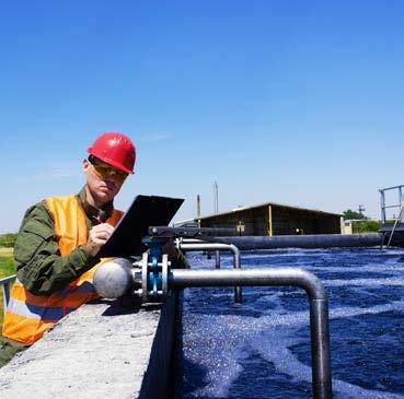
2 UNESCO will make water-related information available online, allowing countries and stakeholders to access reliable data on an open source platform. Leticia Casati, Deputy Permanent Delegate of Paraguay to UNESCO Photographs: Cover: shutterstock / llucky78 shutterstock / Aleksandar Todorovic shutterstock / shutterstock / phoenixman
3 : DATA ABOUT THE GLOBAL WATER CYCLE IS JUST A FEW CLICKS AWAY The International Hydrological Programme s Eighth Phase (IHP-VIII) helps Member States in their quest for Water Security. This objective entails a growing need for enhanced public awareness, improved standards and better coordination among water stakeholders and makes the use of advanced technologies indispensable. To address this challenge, UNESCO-IHP has developed the Water Information Network System, an interactive open-access database, launched in January ( is a global reference database covering the entire water cycle. It provides continuous updates and new data, allowing users to create tailor-made maps incorporating specific information (e.g. on arid zones, rainfall, transboundary water basins and irrigation). combines the largest available validated data on the water cycle. It draws on global information sources such as: The FAO AQUASTAT database The WHO/UNICEF joint monitoring programme The United Nations Statistics Division UNESCO s Water Family including water programmes and initiatives comprising over 3,000 water professionals worldwide. also incorporates key information on UNESCO networks relating to crosscutting waterrelated issues, such as the World Heritage List, Biosphere Reserves and UNESCO Global Geoparks. : AN INTERACTIVE AND USER-FRIENDLY PLATFORM DESIGNED FOR A WIDE AUDIENCE OF WATER STAKEHOLDERS is a user-friendly one-stop shop, offering a wide-ranging set of data services: Access to large datasets on the water cycle at global, regional, national and local levels, both spatial and non-spatial, and supported by standardized metadata (i.e. data about data ). Data available for download by water-related stakeholders, country officials, civil society, international, regional and national institutions, public and private sectors, and academia. A dedicated networking platform also enables the exchange of knowledge and expertise among stakeholders. 3


4 : A geographical information platform A knowledge sharing platform A networking platform 4
5 WHY? MOBILIZING A WATER- DATA REVOLUTION FOR SUSTAINABLE DEVELOPMENT In 2013, the United Nations Secretary-General s High-Level Panel on the Post-2015 Development Agenda called for a Data Revolution for Sustainable Development to improve the quantity and quality of available information. The revolution strives for a new approach to open and free data exchange and collection, as well as the development of innovative methodologies and presentation of disaggregated data and geospatial information, to address cross-cutting issues. As the only intergovernmental programme of the UN system devoted to scientific, educational and capacity development in hydrology, the UNESCO International Hydrological Programme (IHP) is contributing to this data revolution through its Water Information Network System (WINS), the first webbased platform providing information on the water cycle in its entirety. was established as a tool for the implementation and monitoring of IHP-VIII; and to address the request of the IHP s 22nd Intergovernmental Council to provide support to Member States to build their institutional capacities, human resources and a sound basis in science capacity for the monitoring and implementation of Sustainable Development Goal 6 (SDG 6) targets, and those of other water-related goals (Resolution XXII-7; June 2016). It also contributes to the priority Water Action Plan for Climate Resilience, which includes the development of water knowledge, decision support and information systems (WIS). 5
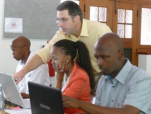
6 A KEY TOOL FOR MONITORING AND IMPLEMENTING SDG 6 ON WATER AND SANITATION Regular data updates are essential for monitoring the SDG 6 indicators on water and sanitation. is a resource-efficient tool for water data collection that helps build a repository of knowledge for water security. It is easy to use and has reduced data entry and retrieval costs. also supports policy processes among Member States that encourage access to open and free data, and the sharing of data between different communities, experts and countries. DEVELOPS CAPACITIES AND FACILITATES DIALOGUE AMONG WATER STAKEHOLDERS As a cooperative platform for water stakeholders, helps to improve institutional and human capacities to ensure high-quality, timely, reliable and disaggregated data. This enhances the capacity of national statistical offices and data systems, especially in developing countries, and provides a solid basis for scientific decision-making. Its interactive approach enables Member States to update and upload national and regional water-related data, facilitating their involvement in the data revolution. Water professionals are invited to use and promote as a networking platform to share experiences and lessons learnt, mentor early career water professionals and strengthen partnerships within the water sector. IN ACTION Stampriet Transboundary Aquifer System (STAS) is currently being used in the assessment of the Stampriet Transboundary Aquifer System (STAS) shared by Botswana, Namibia and South Africa. is playing a crucial role in strengthening water cooperation among the countries. Indeed, Botswana, Namibia and South Africa are using to visualize and generate tailor-made products to meet their specific needs. is also facilitating the exchange of data among national stakeholders, enhancing interdisciplinary cooperation and the creation of networks. 6


7 Borehole yield in the Auob aquifer, Namibia UNESCO Ocotepeque-Citalá Transboundary Aquifer is also being used in the assessment of the Ocotepeque-Citalá Transboundary Aquifer shared by Honduras and El Salvador. Cutting across all the economic sectors, water is instrumental in the implementation of integrated solutions. In general, water resources are commonly developed and managed by different parts of governments and within different sectors, with little coordination among them and without an overall picture of the state of the resource. allows the inclusive participation of a wide range of water stakeholders, i.e. institutions at various levels: national (ministries), regional (Plan Trifinio and Transboundary Lempa River Trinational Intermunicipal Board) and local (municipalities, local water management committees), as well as academia. Lempa River in the Trifinio region UNESCO-IHP/IUCN 7
 and deploying spatial data")
8 HOW DOES INTERACTIVE PLATFORM WORK? System is an open source and open access database. It receives regular technical updates at a low cost, and is built on GeoNode, a web-based application and platform for developing Geospatial Information Systems (GIS) and deploying spatial data infrastructures (SDI). The architecture is designed to be expandable and modifiable, easily integrating (and linking) with existing platforms. It is in line with international Open Geospatial Consortium (OGC) standards that enable access and integration of other databases, and constitutes an example of UNESCO s policy to support open access to scientific information. User interface users can visualize and generate tailor-made products meeting their specific needs. The system also facilitates the exchange of data and ideas among stakeholders, and fosters interdisciplinary cooperation and the creation of networks. It consists of three main components: 1) Geospatial (GIS) data on the state of water resources at the global, regional, national and local level, allowing users to visualize and generate maps 2) A platform for inter-disciplinary collaboration and knowledge sharing among water stakeholders (i.e. databases, reports, graphs, tables, videos, webinars, etc.) 3) A platform for stakeholders to build networks (i.e. discussion groups). geospatial data can be viewed across time and uses a powerful search engine. Data uploaded by users comply with copyrights, intellectual property rights and data agreements. Data security and reliability draws on officially validated data provided by Member States and UNESCO s water programmes and networks. IHP undertakes an overall data format quality check before data are released, which is further reinforced by a data rating and feedback system. Data are then uploaded in line with userdefined permissions. The platform and data are safely stored on UNESCO s servers at its Headquarters in Paris. UNESCO 8
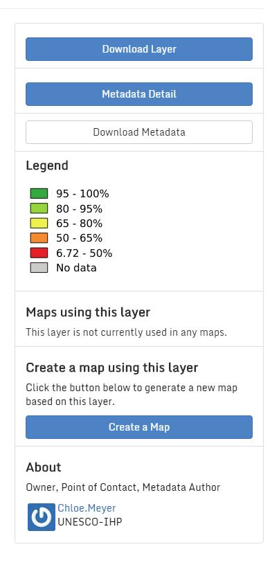
9 WHAT CAN USERS DO WITH? Layers and Maps provide geospatial information GIS is an effective tool to store, manage and display spatial data for water resources management. provides access to GIS data on the state of water resources at the global, regional, national and local level through its Layers function. 9

10 Layers present a spatial data source, either in vector or raster representation. GIS vector data are uploaded in ESRI 1 Shapefile format, and satellite imagery and raster data are uploaded as GeoTIFFs. Layers can be uploaded, viewed and downloaded. Metadata provide information related to each layer (e.g. owner, author, date, source, abstract and contact person). SDG Indicator 6.2.1: Proportion of population using safely managed sanitation services (2015) By stacking Layers, users can generate new pieces of information and create tailored Maps. Users can also print the resulting Maps, save them on the platform, export them in several formats (PDF, JPEG, etc.) and share them for public viewing. 1 The Environmental Systems Research Institute (ESRI) is an international supplier of geographic information system (GIS) software, web GIS and geodatabase management applications. 10
11 Shutterstock / Martchan UNESCO UNESCO / Stampriet 11

.")
12 STRENGTHENS KNOWLEDGE MANAGEMENT AND INSTITUTIONAL MEMORY Knowledge management goes beyond the storage and sharing of data and information. A structured, systematic approach is required to share knowledge with decision-makers in a timely manner, and to ensure sustainable access to information (i.e. institutional memory). Documents function allows users to store and access databases, reports, graphs, tables, videos, webinars and other formats. The documents can then be viewed, printed and/or downloaded. 12


13 HOW TO CONTRIBUTE TO To contribute to, Member States and Institutions could request user accounts at: also welcomes questions, comments or suggestions from users. Please contact UNESCO s team at: ihp-wins@unesco.org is designed, implemented and maintained by the International Hydrological Programme of UNESCO. For more information on IHP initiatives contributing to, please visit our website: 13

 CONTACT INFORMATION INTERNATIONAL HYDROLOGICAL")
14 Watch the video here: graphical representation of reliable data is one of the most powerful ways to raise understanding of one of the most complex problems it will help decision makers. Jack Moss, Executive Director, International Federation of Private Water Operators (AquaFed) CONTACT INFORMATION INTERNATIONAL HYDROLOGICAL PROGRAMME (IHP) UNESCO / DIVISION OF WATER SCIENCES (SC/HYD) 7, PLACE DE FONTENOY PARIS 07 SP FRANCE ihp-wins@unesco.org SC-2017/WS/5
2018/1 The integration of statistical and geospatial information. The Regional Committee of UN-GGIM: Americas:
 The following are the conclusions and recommendations of the Regional Committee of the United Nations on Global Geospatial Information Management for the Americas, during its Fifth Session, Thursday 8
GENERAL RECOMMENDATIONS. Session 7. Breakout discussion. discuss on regional and interregional. proposals 1. COLLABORATION BETWEEN PROGRAMMES
 Session 7 24 July 2016, 9.00-11.00 Breakout discussion on regional and interregional joint project proposals Mr Shahbaz Khan summarized the two days of presentations and exchanges and requested the participants
KUNMING FORUM ON UNITED NATIONS GLOBAL GEOSPATIAL INFORMATION MANAGEMENT CITIES OF THE FUTURE: SMART, RESILIENT
 KUNMING FORUM ON UNITED NATIONS GLOBAL GEOSPATIAL INFORMATION MANAGEMENT CITIES OF THE FUTURE: SMART, RESILIENT and SUSTAINABLE Yunnan Zhenzhuang Guest House, Kunming, China 10 12 May 2017 BACKGROUND CONCEPT
The Global Statistical Geospatial Framework and the Global Fundamental Geospatial Themes
 The Global Statistical Geospatial Framework and the Global Fundamental Geospatial Themes Sub-regional workshop on integration of administrative data, big data and geospatial information for the compilation
UN GGIM and National SDI Strategy
 MSDI Open Forum on 26 th January 2016 Contributing to the successful delivery of MSDI UN GGIM and National SDI Strategy Hiroshi Murakami Deputy Administrator Geospatial Information Authority of Japan Geospatial
Realizing benefits of Spatial Data Infrastructure A user s perspective from Environment Agency - Abu Dhabi
 Realizing benefits of Spatial Data Infrastructure A user s perspective from Environment Agency - Abu Dhabi Anil Kumar Director, Environment Information Management 26 April 2012 Geospatial World Forum,
CHAPTER 22 GEOGRAPHIC INFORMATION SYSTEMS
 CHAPTER 22 GEOGRAPHIC INFORMATION SYSTEMS PURPOSE: This chapter establishes the administration and use of to improve the quality and accessibility of Department s spatial information and support graphical
Making the SDGs work for the Lake Chad Basin
 Making the SDGs work for the Lake Chad Basin SIDE EVENT ON THE MARGINS OF THE 2018 HIGH LEVEL POLITICAL FORUM 16 JULY 2018, 18.30 20.00 CONFERENCE ROOM 11, UN CONFERENCE BUILDING, UNITED NATIONS HEADQUARTERS,
Economic and Social Council
 United Nation E/C.20/2012/4/Add.1 Economic and Social Council Distr.: General 2 July 2012 Original: English Committee of Experts on Global Geospatial Information Management Second session New York, 13-15
Data Aggregation with InfraWorks and ArcGIS for Visualization, Analysis, and Planning
 Data Aggregation with InfraWorks and ArcGIS for Visualization, Analysis, and Planning Stephen Brockwell President, Brockwell IT Consulting, Inc. Join the conversation #AU2017 KEYWORD Class Summary Silos
Implementing the Sustainable Development Goals: The Role of Geospatial Technology and Innovation
 Fifth High Level Forum on UN Global Geospatial Information Management Implementing the Sustainable Development Goals: The Role of Geospatial Technology and Innovation 28-30 November 2017 Sheraton Maria
Empowered lives. Resilient nations. Data for People and Planet. powered by
 Empowered lives. Resilient nations. Data for People and Planet powered by Overview As we enter the fourth industrial revolution, technology is revolutionizing our ability to map nature. Satellite data
How GIS based Visualizations Support Land Use and Transportation Modeling
 How GIS based Visualizations Support Land Use and Transportation Modeling ESRI International Users Conference San Diego, CA - July 23, 2015 Prepared by: Troy Hightower Introduction This presentation will
ArcGIS for Desktop. ArcGIS for Desktop is the primary authoring tool for the ArcGIS platform.
 ArcGIS for Desktop ArcGIS for Desktop ArcGIS for Desktop is the primary authoring tool for the ArcGIS platform. Beyond showing your data as points on a map, ArcGIS for Desktop gives you the power to manage
Briefing. H.E. Mr. Gyan Chandra Acharya
 Briefing by H.E. Mr. Gyan Chandra Acharya Under-Secretary-General and High Representative for the Least Developed Countries, Landlocked Developing Countries and Small Island Developing States Briefing
Disaster Risk Reduction UNESCO s contribution to a global challenge
 Educational, Scientific Cultural Organization Disaster Risk Reduction UNESCO s contribution to a global challenge aming gas crater known as the Door to Hell in Darvaza, Turkmenistan. Shutterstock / Lockenes
COUNCIL OF THE EUROPEAN UNION. Brussels, 2 May /14 CULT 68
 COUNCIL OF THE EUROPEAN UNION Brussels, 2 May 2014 9129/14 CULT 68 NOTE from: General Secretariat of the Council to: Permanent Representatives Committee (Part 1) / Council No. prev. doc.: 8892/14 CULT
Challenges and Successes in Sharing Geospatial Data in Africa
 Challenges and Successes in Sharing Geospatial Data in Africa 2018 GeoNode Summit Torino, Italy March 26-28, 2018 Bernard Justus Muhwezi Manager, Geo-Information Services Uganda Bureau of Statistics, Kampala,
Arctic Spatial Data Infrastructure Enabling Access to Arctic Location-Based Information
 Arctic Spatial Data Infrastructure Enabling Access to Arctic Location-Based Information Arctic SDI Side Event Co-Chairs: Arvo Kokkonen Arctic SDI Board Chair & Director General, National Land Survey of
Transportation and Logistics Planning and Development Mapping Tool
 Transportation and Logistics Planning and Development Mapping Tool Doreen Gonzales-Gaboyan Business Development and Outreach Center for Innovation through Visualization and Simulation (CIVS) Purdue University
Together4Water project. Implementing an open-source database to monitor water-related SDG in Tunisia
 Linked Open Data in Agriculture Together4Water project Implementing an open-source database to monitor water-related SDG in Tunisia Ir. Raed Fehri Supervisors: Prof. Marnik Vanclooster Prof. Kim Mens Berlin,
CLICK HERE TO KNOW MORE
 CLICK HERE TO KNOW MORE GeoSpace for Singapore s Whole-of-Government Data Sharing Asia GeoSpatial Forum 17 19 Oct 2011 Lee Kim Haw Singapore Land Authority Introducing Singapore Land Authority Limited
NEWSLETTER ON THE EVENT Issue 2
 NEWSLETTER ON THE EVENT Issue 2 Integration of Sustainable Development Perspective into WH Convention 14 July 2016 THE PRESENTORS WELCOME AND OPENING The 40 th UNESCO World Heritage Committee Meeting was
Geospatial Information Management in the Americas: Lessons for the Post-2015 development agenda
 Geospatial Information Management in the Americas: Lessons for the Post-2015 development agenda Rolando Ocampo President, UN-GGIM: Americas October 2014 The integration of statistical and geographical
THE SEVILLE STRATEGY ON BIOSPHERE RESERVES
 THE SEVILLE STRATEGY ON BIOSPHERE RESERVES 1 VISION FOR BIOSPHERE RESERVES IN THE 21 ST CENTURY The international Seville Conference on Biosphere Reserves, organised by UNESCO, adopted a two-pronged approach,
Foundation Geospatial Information to serve National and Global Priorities
 Foundation Geospatial Information to serve National and Global Priorities Greg Scott Inter-Regional Advisor Global Geospatial Information Management United Nations Statistics Division UN-GGIM: A global
Second Administrative Level Boundaries (SALB) initiative & geographic names in cartography. Geospatial Information Section
 initiative & geographic names in cartography. Geospatial Information Section") Second Administrative Level Boundaries (SALB) initiative & geographic names in cartography Geospatial Information Section Introduction Goals Global agenda How does SALB work? Latest News on geographic
Second Administrative Level Boundaries (SALB) initiative & geographic names in cartography Geospatial Information Section Introduction Goals Global agenda How does SALB work? Latest News on geographic
GIS at UCAR. The evolution of NCAR s GIS Initiative. Olga Wilhelmi ESIG-NCAR Unidata Workshop 24 June, 2003
 GIS at UCAR The evolution of NCAR s GIS Initiative Olga Wilhelmi ESIG-NCAR Unidata Workshop 24 June, 2003 Why GIS? z z z z More questions about various climatological, meteorological, hydrological and
Colin Bray, OSi CEO. Articulating the Data Needs for SDGs. Collaboration in Ireland
 Ireland Colin Bray, OSi CEO Articulating the Data Needs for SDGs Collaboration in Ireland Articulating the Data Needs for SDGs Ireland Introduction Collaboration between the Irish National Mapping Agency
Geographic Information Infrastructure and Policy Framework for Sustainable Mountain Development in the Hindu Kush-Himalayas
 Geo SMART ASIA 2017 22-24 August, Kualalampur Geographic Information Infrastructure and Policy Framework for Sustainable Mountain Development in the Hindu Kush-Himalayas Basanta Shrestha, Director Strategic
ACTION PLAN FOR WORLD HERITAGE IN LATIN AMERICA AND THE CARIBBEAN ( )
") Annex ACTION PLAN FOR WORLD HERITAGE IN LATIN AMERICA AND THE CARIBBEAN (2014-2024) The current Regional Action Plan for Latin America and the Caribbean for 2014-2024 has been elaborated by the State Parties
Annex ACTION PLAN FOR WORLD HERITAGE IN LATIN AMERICA AND THE CARIBBEAN (2014-2024) The current Regional Action Plan for Latin America and the Caribbean for 2014-2024 has been elaborated by the State Parties
Brian D. George. GIMS Specialist Ohio Coastal Atlas Project Coordinator and Cartographer. Impacts and Outcomes of Mature Coastal Web Atlases
 Ohio Coastal Atlas Project Brian D. George GIMS Specialist Ohio Coastal Atlas Project Coordinator and Cartographer Ohio Department of Natural Resources Office of Coastal Management Sandusky, OH Impacts
Agenda. Status of GI activities. NGII Framework. SDI from the national policy perspective
 Towards a National Geographic Information Infrastructure: Overcoming Impediments to the Development of SDI in Nepal R.R. Chhatkuli Email: chhatkuli@ngiip.gov.np & D.M. Kayastha Email: chhatkuli@ngiip.gov.np
Spatial Data Availability Energizes Florida s Citizens
 NASCIO 2016 Recognition Awards Nomination Spatial Data Availability Energizes Florida s Citizens State of Florida Agency for State Technology & Department of Environmental Protection Category: ICT Innovations
Integrated approaches to the implementation of the Convention on Biological Diversity
 Integrated approaches to the implementation of the Convention on Biological Diversity Actions on ABS in the context of UNESCO Biosphere Reserves Vibeke Jensen, Director UNESCO Liaison Office in New York
A FOSS approach to Integrated Water Resource Management: the case study of Red-Thai Binh rivers system in Vietnam
 A FOSS approach to Integrated Water Resource Management: the case study of Red-Thai Binh rivers system in Vietnam Carolina Arias Munoz1, Maria Antonia Brovelli1, Simone Corti1, Marco Micotti2, Rodolfo
THE ROLE OF GEOSPATIAL AT THE WORLD BANK
 THE ROLE OF GEOSPATIAL AT THE WORLD BANK INSPIRE Conference Barcelona, Spain September 26, 2016 Kathrine Kelm Senior Land Administration Specialist Global Land and Geospatial Unit The World Bank Group
Institute of Statistical and Geographical Information of Jalisco State Subnational Statistical and Geographical System India.
 Institute of Statistical and Geographical Information of Jalisco State Subnational Statistical and Geographical System India. January 2017 Subnational Statistical and Geographical System National Statistical
Oman NSDI Business Values and Future Directions. Hassan Alawi Alghazali Acting Director General National Spatial Data Infrastructure
 Oman NSDI Business Values and Future Directions Hassan Alawi Alghazali Acting Director General National Spatial Data Infrastructure Presentation Outline Geospatial Maturity Current Challenges NCSI s Role
Aboriginal communities strengthen governance with location-based tools in the 21st century
 Aboriginal communities strengthen governance with location-based tools in the 21st century Today, Aboriginal communities are taking advantage of the geomatics technologies that underpin popular online
Concept note. High-Level Seminar: Accelerating Sustainable Energy for All in Landlocked Developing Countries through Innovative Partnerships
 Concept note High-Level Seminar: Accelerating Sustainable Energy for All in Landlocked Developing Countries through Innovative Partnerships Date: 24 and 25 October 2016 Venue: Conference Room C3, Vienna
KENYA NATIONAL BUREAU OF STATISTICS Workshop on
 KENYA NATIONAL BUREAU OF STATISTICS Workshop on Capacity Building in Environment Statistics: the Framework for the Development of Environment Statistics (FDES 2013) Coordination with Sector Ministries
Economic and Social Council
 United Nations Economic and Social Council Distr.: General 18 July 2016 Original: English Committee of Experts on Global Geospatial Information Management Sixth session New York, 3-5 August 2016 Item 2
Declaration Population and culture
 Declaration Population and culture The ministers of the parties to the Alpine Convention regard the socio-economic and socio-cultural aspects mentioned in Article 2, Paragraph 2, Item a., as being central
Copernicus Relays. Roles and responsibilities of the Copernicus Relays. user uptake
 Copernicus Relays user uptake Roles and responsibilities of the Copernicus Relays The European Commission has launched two Networks, the Copernicus Relays and the Copernicus Academy, to contribute to spreading
GLOBAL GEOPARKS NETWORK
 GLOBAL GEOPARKS NETWORK International Association on Geoparks CELEBRATING EARTH HERITAGE SUSTAINING LOCAL COMMUNITIES REQUEST FOR PROPOSALS Communication & Marketing Strategy FOR UNESCO Global Geoparks
UN-GGIM: Strengthening Geospatial Capability
 Fifth Plenary Meeting of UN-GGIM: Europe Brussels, 6-7 June 2018 UN-GGIM: Strengthening Geospatial Capability Walking the talk to leave no one behind Greg Scott, UN-GGIM Secretariat Environmental Statistics
ArcGIS. for Server. Understanding our World
 ArcGIS for Server Understanding our World ArcGIS for Server Create, Distribute, and Manage GIS Services You can use ArcGIS for Server to create services from your mapping and geographic information system
Ministry of Health and Long-Term Care Geographic Information System (GIS) Strategy An Overview of the Strategy Implementation Plan November 2009
 Strategy An Overview of the Strategy Implementation Plan November 2009") Ministry of Health and Long-Term Care Geographic Information System (GIS) Strategy An Overview of the Strategy Implementation Plan November 2009 John Hill, Health Analytics Branch Health System Information
Ministry of Health and Long-Term Care Geographic Information System (GIS) Strategy An Overview of the Strategy Implementation Plan November 2009 John Hill, Health Analytics Branch Health System Information
RESAP Progress Report
 RESAP Progress Report December 2016 to October 2017 Presentation to the Twenty-first session of the Intergovernmental Consultative Committee on the Regional Space Applications Programme for Sustainable
Spatial decision making in Armenia based on multidisciplinary environmental research
 EU FP7 EcoArm2ERA Integration into ERA Integration of spatial decision support systems and evidence based modeling in National/Regional Policy applications and regulatory systems: scientific and policy
The GIS Path Forward Saskatchewan s Geomatics Strategic Plan
 The GIS Path Forward Saskatchewan s Geomatics Strategic Plan John Potter, SK Ministry of Central Services Office of Geomatics Coordination Sept.17/13 Table of Contents 1. 2011-2016, Geomatics Strategic
Educational Qualification No ( No of Positions) 01. Geographic
 01. Geographic") ICZMP, State Project Management Unit-Orissa Plot # 108,Unit VII, Suryanagar,Bhubaneswar 751 003 ICZMP invites applications from eligible candidates for filling up of posts as mentioned below under the
ICZMP, State Project Management Unit-Orissa Plot # 108,Unit VII, Suryanagar,Bhubaneswar 751 003 ICZMP invites applications from eligible candidates for filling up of posts as mentioned below under the
Concept Formulation of Geospatial Infrastructure. Hidenori FUJIMURA*
 Concept Formulation of Geospatial Infrastructure 1 Concept Formulation of Geospatial Infrastructure Hidenori FUJIMURA* (Published online: 28 December 2016) Abstract Technical trends in the field of surveying
Disaster Management & Recovery Framework: The Surveyors Response
 Disaster Management & Recovery Framework: The Surveyors Response Greg Scott Inter-Regional Advisor Global Geospatial Information Management United Nations Statistics Division Department of Economic and
UNITED NATIONS GEOGRAPHIC INFORMATION WORKING GROUP
 UNGIWG UNITED NATIONS GEOGRAPHIC INFORMATION WORKING GROUP New York, May 2014 UNSPACE & UNGIWG 14 INTRO. The United Nations Geographic Information Working Group (UNGIWG) is a voluntary network of UN professionals
E/CONF.105/158/CRP.158
 E/CONF.105/158/CRP.158 14 July 2017 Original: English Eleventh United Nations Conference on the Standardization of Geographical Names New York, 8-17 August 2017 Item 8 of the provisional agenda* Measures
Implementation of Inspire in Denmark - How we get it flying! Olav Eggers National Survey & Cadastre -Denmark
 Implementation of Inspire in Denmark - How we get it flying! Olav Eggers oe@kms.dk National Survey & Cadastre -Denmark Introduction Overview Infrastructure for Spatial Information Act National Survey and
Statement of Mr. Sandagdorj Erdenebileg, Chief, Policy Development, Coordination, Monitoring and Reporting Service, UN-OHRLLS.
 Statement of Mr. Sandagdorj Erdenebileg, Chief, Policy Development, Coordination, Monitoring and Reporting Service, UN-OHRLLS at the Botswana National Workshop on the Vienna Programme of Action 27 th October
Areas Beyond National Jurisdiction (ABNJ) 2016 Regional Leaders Program. March 22 to April 1, 2016 United Nations, New York
 2016 Regional Leaders Program. March 22 to April 1, 2016 United Nations, New York") Areas Beyond National Jurisdiction (ABNJ) 2016 Regional Leaders Program March 22 to April 1, 2016 United Nations, New York Welcome and Introductions Biliana Cicin-Sain President, Global Ocean Forum Vladimir
Areas Beyond National Jurisdiction (ABNJ) 2016 Regional Leaders Program March 22 to April 1, 2016 United Nations, New York Welcome and Introductions Biliana Cicin-Sain President, Global Ocean Forum Vladimir
Oman NSDI Supporting Economic Development. Saud Al-Nofli Director of Spatial Data Directorate General of NSDI, NCSI
 Oman NSDI Supporting Economic Development 2017 Saud Al-Nofli Director of Spatial Data Directorate General of NSDI, NCSI "It s critical to make correct decisions the first time to optimize the Investments
Urban Climate Resilience
 Urban Climate Resilience in Southeast Asia Partnership Project Introduction Planning for climate change is a daunting challenge for governments in the Mekong Region. Limited capacity at the municipal level,
Towards Reliable Spatial Database of Informal Areas in Greater Cairo Region
 KEYWORDS informal areas, unreliable spatial data, spatial data collecting, capacity building SUMMARY The uncontrolled and rapid increase of Egypt s cities is a major problem of the country. More than the
Creation of an Internet Based Indiana Water Quality Atlas (IWQA)
") Department of Environmental Management Creation of an Internet Based Water Quality Atlas (IWQA) May 4, 2005 IUPUI 1200 Waterway Blvd., Suite 100 polis, 46202-5140 Water Quality Atlas John Buechler, Neil
Department of Environmental Management Creation of an Internet Based Water Quality Atlas (IWQA) May 4, 2005 IUPUI 1200 Waterway Blvd., Suite 100 polis, 46202-5140 Water Quality Atlas John Buechler, Neil
Economic and Social Council
 United Nations E/CN.3/2019/31 Economic and Social Council Distr.: General 19 December 2018 Original: English Statistical Commission Fiftieth session 5-8 March 2019 Item 4(i) of the provisional agenda*
Spatial data interoperability and INSPIRE compliance the platform approach BAGIS
 Spatial data interoperability and INSPIRE compliance the platform approach BAGIS BAGIS Voluntary, independent, public, non-profit organization; Organization with main mission to promote the growth of the
Nomination Form. Clearinghouse. New York State Office for Technology. Address: State Capitol-ESP, PO Box
 NASIRE 2001 RECOGNITION AWARDS Recognizing Outstanding Achievement in the Field of Innovative Use of Technology Nomination Form Title of Nomination: Manager/Job Title: Agency: NYS Geographic Information
PROGRESS REPORT ON APPROACH PAPER THE IMPLEMENTATION OF THE GEF KNOWLEDGE MANAGEMENT. GEF/C.49/Inf.04 September 23, 2015
 49 th GEF Council Meeting October 20 22, 2015 Washington, D.C. GEF/C.49/Inf.04 September 23, 2015 PROGRESS REPORT ON THE IMPLEMENTATION OF THE GEF KNOWLEDGE MANAGEMENT APPROACH PAPER TABLE OF CONTENTS
GEOGRAPHIC INFORMATION SYSTEMS Session 8
 GEOGRAPHIC INFORMATION SYSTEMS Session 8 Introduction Geography underpins all activities associated with a census Census geography is essential to plan and manage fieldwork as well as to report results
IAEG SDGs WG GI, , Mexico City
 IAEG SDGs WG GI, 12-14.12.2016, Mexico City UN-GGIM:Europe s perspective and activities to support better integration of geospatial information and statistics and the UN SDG monitoring Pier-Giorgio Zaccheddu,
INSPIRing Geospatial Framework For Local Administrations
 This project is financed by the European Union and the Republic of Turkey Presented at the FIG Congress 2018, May 6-11, 2018 in Istanbul, Turkey National Programme for Turkey 2010 Instrument for Pre-Accession
Economic and Social Council 2 July 2015
 ADVANCE UNEDITED VERSION UNITED NATIONS E/C.20/2015/11/Add.1 Economic and Social Council 2 July 2015 Committee of Experts on Global Geospatial Information Management Fifth session New York, 5-7 August
US National Spatial Data Infrastructure A Spatial Framework for Governance and Policy Development to Enable a Location-Based Digital Ecosystem
 GeoPlatform Workshop 7 Dec 2016, Department of the Interior Washington, D.C. US National Spatial Infrastructure A Spatial Framework for Governance and Policy Development to Enable a Location-Based Digital
AAG Partnerships for. Sustainable Development in Africa: Geospatial Science & Technology for. Partnerships and Applications
 AAG Partnerships for Sustainable Development in Africa Geospatial Science & Technology for Sustainable Development in Africa: Partnerships and Applications Harvard University John F. Kennedy School of
What s the problem? A Modern Odyssey in Search of Relevance. The search for relevance. Some current drivers for new services. Some Major Applications
 A Modern Odyssey in Search of Relevance FIG Working Week, Athens, 24 May 2004 Paul Kelly ANZLIC Executive Director The search for relevance 1. New expectations for spatial services 2. Are we ready to meet
Spatially Enabled Society
 International Seminar on Land Administration Trends and Issues in Asia and the Pacific Region Spatially Enabled Society Abbas Rajabifard Vice Chair PCGIAP-WG3 Vice-President (President Elect), GSDI Association
Z A M B E Z I W A T E R R E S O U R C E S I N F O R M A T I O N S Y S T E M ( Z A M W I S )
") Z A M B E Z I W A T E R R E S O U R C E S I N F O R M A T I O N S Y S T E M ( Z A M W I S ) Angola Botswana Malawi Mozambique Namibia Tanzania Zambia Zimbabwe Win-win cooperation/ Cooperacao, ganhas tu,
Z A M B E Z I W A T E R R E S O U R C E S I N F O R M A T I O N S Y S T E M ( Z A M W I S ) Angola Botswana Malawi Mozambique Namibia Tanzania Zambia Zimbabwe Win-win cooperation/ Cooperacao, ganhas tu,
UNESCO Earth Science Education Initiative in Africa Initial Activities
 UNESCO Earth Science Education Initiative in Africa Initial Activities S. Felix Toteu 1 and Sarah Gaines 2 1 UNESCO Nairobi Office, Kenya 2 UNESCO Headquarters, Paris In Arusha, Tanzania on 8 May 2008
Sustainable Development Goals UN-GGIM Task Team
 Sustainable Development Goals UN-GGIM Task Team Executive Committee Meeting, 1. June 2016 Kristian Møller Copyright 2013 EuroGeographics Developments Creation of the One pager and matrix Reviewed by UN-GGIM:
Economic and Social Council
 United Nations Economic and Social Council Distr.: General 2 July 2012 E/C.20/2012/10/Add.1 Original: English Committee of Experts on Global Geospatial Information Management Second session New York, 13-15
Statutory Framework of Biosphere Reserves. The Statutory Framework of the World Network of Biosphere Reserves
 Page 1 of 5 The Statutory Framework of the World Network of Biosphere Reserves Introduction Article 1 - Definition Article 2 - World Network of Biosphere Reserves Article 3 - Functions Article 4 - Criteria
Water Data Sharing an Update
 Water Data Sharing an Update By David R. Maidment Leader, CUAHSI Hydrologic Information System Project and Director, Center for Research in Water Resources, University of Texas at Austin Prepared for Subcommittee
The Integrated Ge spatial Information Framework to the strengthening of NSDI, Mongolia
 Young Geospatial Professionals Summit 21 NOV 2018 The Integrated Ge spatial Information Framework to the strengthening of NSDI, Mongolia BAYARMAA ENKHTUR Geospatial information and technology department
Remarks. for. H.E. Mr. Gyan Chandra Acharya
 Please check against delivery Remarks for H.E. Mr. Gyan Chandra Acharya Under-Secretary-General and High Representative for the Least Developed Countries, Landlocked Developing Countries and Small Island
The Process of Spatial Data Harmonization in Italy. Geom. Paola Ronzino
 The Process of Spatial Data Harmonization in Italy Geom. Paola Ronzino ISSUES Geospatial Information in Europe: lack of data harmonization the lack of data duplication of data CHALLENGES Challenge of INSPIRE:
REPORT ON ACTIVITIES UNDERTAKEN SINCE THE 25TH SESSION OF THE INTERNATIONAL COORDINATING COUNCIL OF THE MAN & THE BIOSPHERE PROGRAMME
 AFRICAN NETWORK OF BIOSPHERE RESERVES (AFRIMAB) REPORT ON ACTIVITIES UNDERTAKEN SINCE THE 25TH SESSION OF THE INTERNATIONAL COORDINATING COUNCIL OF THE MAN & THE BIOSPHERE PROGRAMME 26 TH MAB ICC SESSION
ACTION PLAN FOR WORLD HERITAGE IN LATIN AMERICA AND THE CARIBBEAN
 Final version-to send to the ACTION PLAN FOR WORLD HERITAGE IN LATIN AMERICA AND THE CARIBBEAN 2014-2024 The current Regional Action Plan for Latin America and the Caribbean has been elaborated by the
Statutory framework of the world network of biosphere reserves UNESCO General Conference 1996
 Statutory framework of the world network of biosphere reserves UNESCO General Conference 1996 Keywords: conservation, protected areas, biosphere reserves, policies, strategies. For the Mountain Forum's
Ministry of ICT of I.R.IRAN
 The ECO 8/6 mill km 2 10 Slamic countries ~330 mill people Oil, Gas, Industries,Tourism 2 Issue transformation in last decade Problem solving needs more integrated approach More interaction &complexity
XXIII CONGRESS OF ISPRS RESOLUTIONS
 XXIII CONGRESS OF ISPRS RESOLUTIONS General Resolutions Resolution 0: Thanks to the Czech Society commends: To congratulate The Czech Society, its president and the Congress Director Lena Halounová, the
Geog 469 GIS Workshop. Managing Enterprise GIS Geodatabases
 Geog 469 GIS Workshop Managing Enterprise GIS Geodatabases Outline 1. Why is a geodatabase important for GIS? 2. What is the architecture of a geodatabase? 3. How can we compare and contrast three types
Contents: LEVANTE DE ALMERÍA A INFORMATION SYSTEM OBJECTIVES AND ACTIONS GEOGRAPHIC INFORMATION SYSTEM RESULTS
 Contents: LEGAL FRAMEWORK: BARCELONA CONVENTION AND ICZM PROTOCOL; COASTAL AREAS MANAGEMENT PROGRAMME; CAMP LEVANTE DE ALMERIA; OVERALL AIM AND KEY IDEAS AREA PHASES PROJECT STRUCTURE ACTIVITIES INSTITUTIONAL
Write a report (6-7 pages, double space) on some examples of Internet Applications. You can choose only ONE of the following application areas:
 on some examples of Internet Applications. You can choose only ONE of the following application areas:") UPR 6905 Internet GIS Homework 1 Yong Hong Guo September 9, 2008 Write a report (6-7 pages, double space) on some examples of Internet Applications. You can choose only ONE of the following application
UPR 6905 Internet GIS Homework 1 Yong Hong Guo September 9, 2008 Write a report (6-7 pages, double space) on some examples of Internet Applications. You can choose only ONE of the following application
GEOMATICS. Shaping our world. A company of
 GEOMATICS Shaping our world A company of OUR EXPERTISE Geomatics Geomatics plays a mayor role in hydropower, land and water resources, urban development, transport & mobility, renewable energy, and infrastructure
Key Indicators for Territorial Cohesion & Spatial Planning Stakeholder Workshop - Project Update. 13 th December 2012 San Sebastián, Basque Country
 Key Indicators for Territorial Cohesion & Spatial Planning Stakeholder Workshop - Project Update 13 th December 2012 San Sebastián, Basque Country Key Aims Explore the use of territorial data in developing
ALBANIA IN THE GLOBAL MAP. Milot LUBISHTANI, Bashkim IDRIZI
 ALBANIA IN THE GLOBAL MAP Milot LUBISHTANI, Bashkim IDRIZI Overview: Introduction GSDI Global Mapping Introduction Standards Participating Utilization Data structure Albanian Global Map Dataset Process
Statement (India) at the 1 st High Level Forum Meeting of United Nations Global Geospatial Information Management held at Seoul on 24 th October 2011
 at the 1 st High Level Forum Meeting of United Nations Global Geospatial Information Management held at Seoul on 24 th October 2011") Statement (India) at the 1 st High Level Forum Meeting of United Nations Global Geospatial Information Management held at Seoul on 24 th October 2011 T Ramasami, Secretary to The Government of India, Ministry
Statement (India) at the 1 st High Level Forum Meeting of United Nations Global Geospatial Information Management held at Seoul on 24 th October 2011 T Ramasami, Secretary to The Government of India, Ministry
Developing national SDI platform for Greece
 SDI Developing national SDI platform for Greece This paper aims to develop a National SDI model for Greece incorporating theoretical and conceptual aspects S ALEXIADOU AND A RAJABIFARD The Spatial Data
Inventory of United Nations Resolutions on Cartography Coordination, Geographic Information and SDI 1
 Inventory of United Nations Resolutions on Cartography Coordination, Geographic Information and SDI I. Resolutions on Cartography Coordination and Establishment of United Nations Regional Cartographic
Statement. H.E. Mr. Gyan Chandra Acharya
 As delivered Statement by H.E. Mr. Gyan Chandra Acharya Under-Secretary-General and High Representative for the Least Developed Countries, Landlocked Developing Countries and Small Island Developing States