GeoSpatial Tools and Analysis David Currie
|
|
|
- Steven Sherman
- 5 years ago
- Views:
Transcription
1 GeoSpatial Tools and Analysis David Currie GeoSpatial Tools and Analysis Data for Good Sept 23, 2014 Focus on open source tools Bias towards remote sensing topics Some examples from completed projects David Currie, P.Eng Open Source Geo Tools A good place to start: GUI tools for GIS and Image Analysis QGIS, OpenJUMP, Grass Command line utilities GDAL/OGR GEOS Proj4 Ossim Databases and Web Services PostGIS/PostgreSQL Mapserver, OpenLayers/GeoMoose, Leaflet 1
2 Django/GeoDjango Scripting tools R Python Quantum GIS (QGIS) Useful for Raster and Vector Exploration Basic mapping capabilities Scriptable using Python Grass Very capable raster and vector processing Good performance Steep learning curve GDAL/OGR Raster and Vector format translations Datum and projection transformations many useful utilities, eg gdalwarp 2

3 GEOS topology library computes useful things like INTERSECTION and CONVEXHULL included in PostGIS Web Services Mapserver custom map generation on demand 3
4 can also function as a tileserver GeoDjango Python based CMS with PostGIS in the background Client-side tools (javascript) Openlayers/GeoMoose Leaflet PostGIS Spatial engine running on PostgreSQL handles vector and raster data provides Proj4 and GEOS functionality for projections and topology library("rpostgresql") v<-dbsendquery(con,"select gid, length, width from feature_polygon where featuretype_id=22") exfeat<-fetch(v,n=-1) hist(exfeat$length,main="length of Extreme Features",xlab="Length (m)",breaks="fd",col="lightblue") Length of Extreme Features Frequency Length (m) 4
5 Scripting: R R-project free and open source powerful statistical capabilities package system to link external capabilities, including GDAL, GEOS, GRASS, Raster, Spatial, SQL... - RStudio IDE 5

6 Scripting: Python free and open source lightweight, useful for web servers lower level programming interface than R, can give higher performance 6
7 useful GIS libraries available: fiona, shapely, pyproj, Rtree Open Geo Data Worldwide Data - OpenStreetMap - Natural Earth - NASA nasa.gov/ - USGS Canada Specific - GeoBase - GeoGratis - Altalis - Calgary Open Data 7
8 8

9 Project Examples: Web Data Capture The problem: capture dimensions of thousands of sea ice features from hundreds of images in order to quantify the variation in size by season and location. The deliverable: Probability of exceedence statistics for each zone and season 9
10 Exceedence Probability Area 2 Iceberg Diameter (m) Note Log Scale n:6470 m:0 Web Data Capture Tools PostGIS/PostgreSQL Python with GDAL for data loading Grass for image enhancement Mapserver with GeoMoose for web based digitizing Django for project administration and reporting R and QGIS for generation of results 10

11 Web Data Capture 11
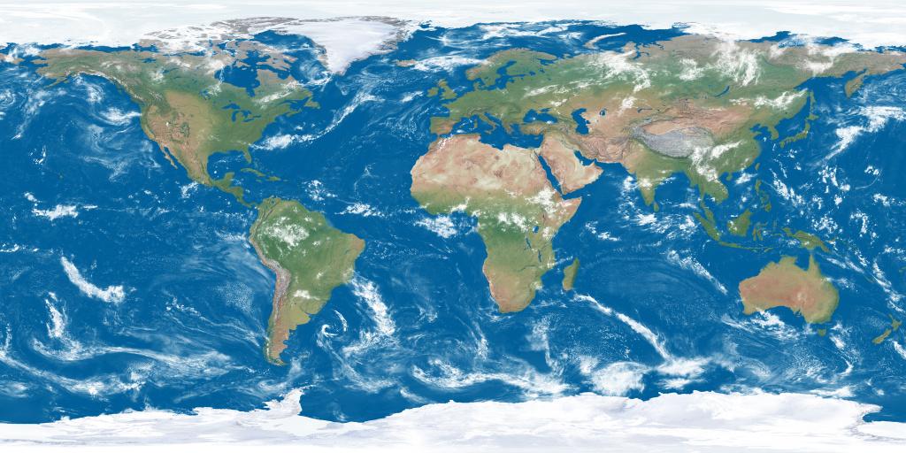
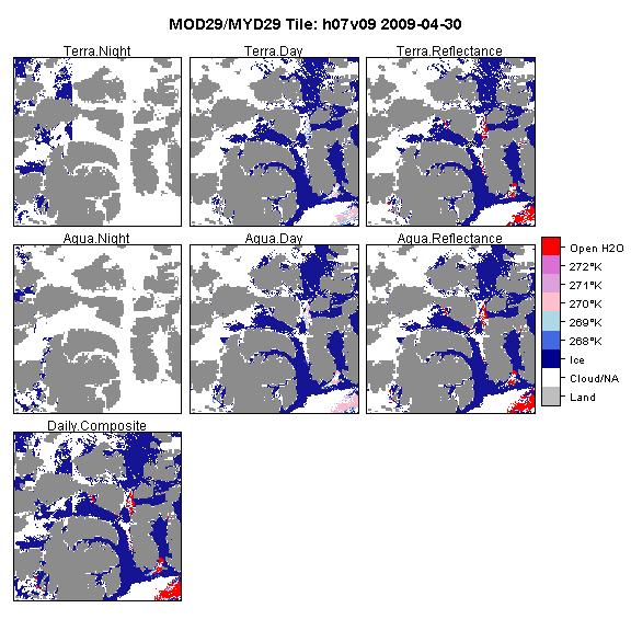
12 12

13 Web Data Capture 13
14 14

15 Web Data Capture 15

16 Web Data Capture Results: - Selected 408 images from a set of 2073 (Landsat and Aster) - 45,578 icebergs detected and measured - 3,292 other significant features detected - Multiple dates between allowed movement to be detected and mapped 16

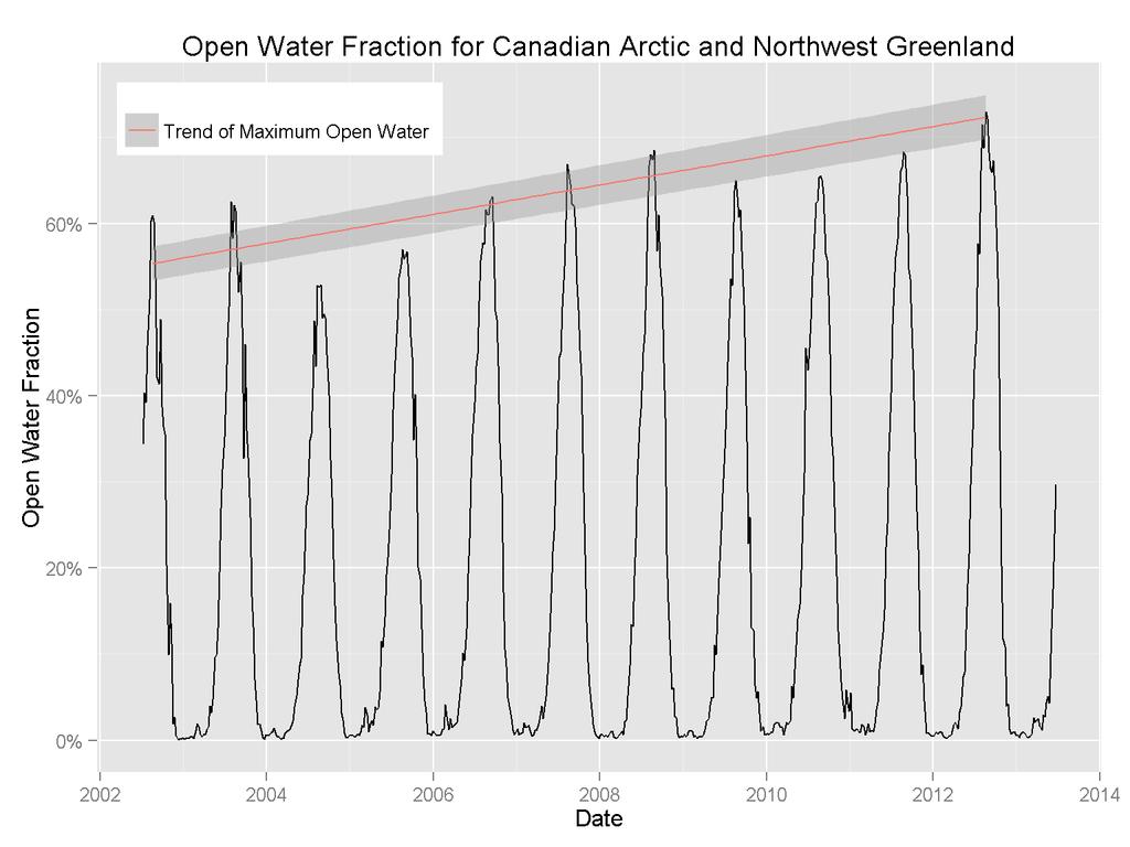
17 Project Examples: Raster Data Mining 17
18 The problem: Arctic polynyas are ephemeral features that are critical to wildlife and human survival. Where and when they occur is difficult to map due to access and weather conditions. The deliverable: Spatio-temporal analysis of open water occurrence for period July June 2013 Tools: - R with spatial and raster packages 18

19 Raster Data Mining Starting from MODIS sea surface temperature grids. - 1 km resolution - Two grids produced per day 19

20 Raster Data Mining Day and Night grids give up to 6 observations of each square kilometer Cloud and lack of sunlight affect available data 20
21 21
22 Raster Data Mining Over 110K images collected, registered, classified, and stacked 22

23 23
24 Raster Data Mining Although daily data is available, the coverage was not continuous Daily data was stacked and filtered to generate a weekly time series A set of open water composite maps were generated for each week of the 11 year span 24


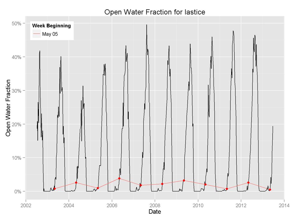
25 25


26 Raster Data Mining Landsat imagery was used to tune the analysis and quality control the result. 26
27 Raster Data Mining Summary statistics from the resulting grids were extracted and analyzed Open water fraction gives a normalized comparison 27
28 28
29 Raster Data Mining Polynyas are most easily recognizable in the early Spring Comparing maps from specific week between years gives a good indication of variation 29

30 30
31 31
32 Raster Data Mining Specific locations were of interest, including the Last Ice Area 32
33 33
34 34

35 Thanks! 35
PostGIS Cookbook. open source I community experience distilled
 PostGIS Cookbook Over 80 task-based recipes to store, organize, manipulate, and analyze spatial data in a PostGIS database Paolo Corti Thomas J Kraft Stephen Vincent Mather Bborie Park PUBLISHING open
Leveraging Your Geo-spatial Data Investments with Quantum GIS: an Open Source Geographic Information System
 Leveraging Your Geo-spatial Data Investments with Quantum GIS: an Open Source Geographic Information System Donald L. Schrupp Colorado Division of Wildlife (Retired) Danny Lewis Texas Parks and Wildlife
Karsten Vennemann, Seattle. QGIS Workshop CUGOS Spring Fling 2015
 Karsten Vennemann, Seattle 2015 a very capable and flexible Desktop GIS QGIS QGIS Karsten Workshop Vennemann, Seattle slide 2 of 13 QGIS - Desktop GIS originally a GIS viewing environment QGIS for the
YYT-C3002 Application Programming in Engineering GIS I. Anas Altartouri Otaniemi
 YYT-C3002 Application Programming in Engineering GIS I Otaniemi Overview: GIS lectures & exercise We will deal with GIS application development in two lectures. Because of the versatility of GIS data models
Why GIS & Why Internet GIS?
 Why GIS & Why Internet GIS? The Internet bandwagon Internet mapping (e.g., MapQuest) Location-based services Real-time navigation (e.g., traffic) Real-time service dispatch Business Intelligence Spatial
Existing Open Source Tools and Possibilities for Cadastre Systems
 Existing Open Source Tools and Possibilities for Cadastre Systems Gertrude Pieper Espada FIG Congress Sydney, 11-16 April 2010 What is FLOSS? What is open source? What open source software tools are available?
Free and Open Source Software for Cadastre and Land Registration : A Hidden Treasure? Gertrude Pieper Espada. Overview
 Free and Open Source Software for Cadastre and Land Registration : A Hidden Treasure? Gertrude Pieper Espada Overview FLOSS concepts Digital Land Administration systems FLOSS Database alternatives FLOSS
Open Source Technologies and Remotely Sensed Data in Protecting Elephants. Rosemary Alles Dr. Justine Blanford Penn State World Campus July 2015
 Open Source Technologies and Remotely Sensed Data in Protecting Elephants Rosemary Alles Dr. Justine Blanford Penn State World Campus July 2015 Global Crisis: Poaching & Wildlife Trafficking 100,000 Elephants
Free Open Source Software: FOSS Based GIS for Spatial Retrievals of Appropriate Locations for Ocean Energy Utilizing Electric Power Generation Plants
 Free Open Source Software: FOSS Based GIS for Spatial Retrievals of Appropriate Locations for Ocean Energy Utilizing Electric Power Generation Plants Kohei Arai 1 Graduate School of Science and Engineering
Methodological Chain for Hydrological Management with Web-GIS Applications
 Advances in Geosciences Konstantinos Perakis & Athanasios Moysiadis, Editors EARSeL, 2012 Methodological Chain for Hydrological Management with Web-GIS Applications Alexandros Konstantinidis 1, Eleni Tzanou
Application of WebGIS and VGI for Community Based Resources Inventory. Jihn-Fa Jan Department of Land Economics National Chengchi University
 Application of WebGIS and VGI for Community Based Resources Inventory Jihn-Fa Jan Department of Land Economics National Chengchi University OUTLINE Introduction Methodology Results Conclusions 2 MOTIVATION
These modules are covered with a brief information and practical in ArcGIS Software and open source software also like QGIS, ILWIS.
 Online GIS Training and training modules covered are: 1. ArcGIS, Analysis, Fundamentals and Implementation 2. ArcGIS Web Data Sharing 3. ArcGIS for Desktop 4. ArcGIS for Server These modules are covered
Introduction to geoprocessing services using SEXTANTE. Víctor Olaya SEXTANTE Geospatial Services
 Introduction to geoprocessing services using SEXTANTE. Víctor Olaya SEXTANTE Geospatial Services Overview Quick introduction to SEXTANTE Client/Server fundamentals Standards for web-based geoservices SEXTANTE
Geographic Information Data, Analysis & Representation
 Geographic Information Data, Analysis & Representation Michaela Kinberger University of Vienna Department of Geography and Regional Research 31 48 44 N 78 39 33 E Geographic Phenomena Types of Geographic
Practical teaching of GIS at University of Liège
 Practical teaching of GIS at University of Liège Jean-Paul Kasprzyk, assistant Lessons Pr. Jean-Paul Donnay: For non-geographers (geologists, urban planners, engineers ) GIS users Master: Introduction
Salisbury University: Eric Flint, John O Brien, & Alex Nohe
 Salisbury University: Eric Flint, John O Brien, & Alex Nohe Open Source (Public) Geographic Information System GNU General Public License Guarantees public s ability to download, modify and share software
gvsig a real tool for GIS technicians
 gvsig a real tool for GIS technicians Jorge Gaspar Sanz Salinas jsanz@prodevelop.es International Geodetic Students Meeting 05/05/08 Valencia Agenda of the project OK, but what can gvsig do for me now?
Overview of Geospatial Open Source Software which is Robust, Feature Rich and Standards Compliant
 Overview of Geospatial Open Source Software which is Robust, Feature Rich and Standards Compliant Cameron SHORTER, Australia Key words: Open Source Geospatial Foundation, OSGeo, Open Standards, Open Geospatial
Among various open-source GIS programs, QGIS can be the best suitable option which can be used across partners for reasons outlined below.
 Comparison of Geographic Information Systems (GIS) software As of January 2018, WHO has reached an agreement with ESRI (an international supplier of GIS software) for an unlimited use of ArcGIS Desktop
Scalable Datacube Analytics with rasdaman
 Scalable Datacube Analytics with Peter Baumann GmbH, Germany [gamingfeeds.com] :: CEOS WGISS :: 2017 :: CEOS WGISS :: 2017 :: CEOS :: WGISS 2017 :: 2017 OGC WCPS: Analyzing Datacubes Web Coverage Processing
GIS for Business Intelligence: Getting Cloud Connected
 GIS for Business Intelligence: Getting Cloud Connected Ed Farrell Director of GIS Solutions, DVG efarrell@dvginteractive.com http://dvginteractive.com October 19 th, 2017 Lake Placid Convention Center
DP Project Development Pvt. Ltd.
 Dear Sir/Madam, Greetings!!! Thanks for contacting DP Project Development for your training requirement. DP Project Development is leading professional training provider in GIS technologies and GIS application
OSGIS Platform. Storing and distributing PostGIS, Deegree, UMN Map Server Desktop visualization JUMP, QGIS, Thuban, udig, gvsig
 GIS groups of tasks Geodata collecting, updating Geodata storing and distributing Geodata analysis Geodata visualization: Desktop, Internet, Printing Geodata describing: metadata management Geodata converting:
Findings from a Search for R Spatial Analysis Support. Donald L. Schrupp Wildlife Ecologist Colorado Division of Wildlife (Retired)
") Findings from a Search for R Spatial Analysis Support Donald L. Schrupp Wildlife Ecologist Colorado Division of Wildlife (Retired) Findings from a Search for R Spatial Analysis Support === Approach Steps
Findings from a Search for R Spatial Analysis Support Donald L. Schrupp Wildlife Ecologist Colorado Division of Wildlife (Retired) Findings from a Search for R Spatial Analysis Support === Approach Steps
Esri Overview for Mentor Protégé Program:
 Agenda Passionate About Helping You Succeed Esri Overview for Mentor Protégé Program: Northrop Grumman CSSS Jeff Dawley 3 September 2010 Esri Overview ArcGIS as a System ArcGIS 10 - Map Production - Mobile
SpatialKit and SEXTANTE
 Free & Open Source Extensions SpatialKit and SEXTANTE for ArcGIS Desktop 9 and 10 Karsten Vennemann, Terra GIS Ltd. www.terragis.net Seattle, WA, USA karsten@terragis.net 206 905 1711 Talk Overview SpatialKit
POSITION DESCRIPTION. Position Title: Geographic Information Systems (GIS) Coordinator Department: Engineering
 Coordinator Department: Engineering") POSITION DESCRIPTION Position Title: Geographic Information Systems (GIS) Coordinator Department: Engineering Reports To: Engineering Supervisor FLSA Status: Exempt Date: April 2018 PRIMARY OBJECTIVE OF
POSITION DESCRIPTION Position Title: Geographic Information Systems (GIS) Coordinator Department: Engineering Reports To: Engineering Supervisor FLSA Status: Exempt Date: April 2018 PRIMARY OBJECTIVE OF
Free Open Source Software for Geoinformatics (FOSS4G) A Practical Example System for Automated Geoscientific Analyses (SAGA)
 A Practical Example System for Automated Geoscientific Analyses (SAGA)") Free Open Source Software for Geoinformatics (FOSS4G) A Practical Example System for Automated Geoscientific Analyses (SAGA) Zlatko Horvat, MSc DGU Područni ured za katastar Čakovec My Motivation Give
Free Open Source Software for Geoinformatics (FOSS4G) A Practical Example System for Automated Geoscientific Analyses (SAGA) Zlatko Horvat, MSc DGU Područni ured za katastar Čakovec My Motivation Give
European Space Agency
 Guidelines - Guidelines how/when to interact during the WebEx session: - Due to the number of attendees, please keep always your webcam and microphone switched-off - You can use anytime the chat to all
Introduction to the 176A labs and ArcGIS Purpose of the labs
 Introduction to the 176A labs and ArcGIS Purpose of the labs Acknowledgement: Slides by David Maidment, U Texas-Austin and Francisco Olivera (TAMU) Hands-on experience with a leading software package Introduction
Maps, Graphs and Metrics: How Local Agencies Put Data to Work. Vivien Deparday Manager of the Community Information and Mapping System June 20, 2012
 Maps, Graphs and Metrics: How Local Agencies Put Data to Work Vivien Deparday Manager of the Community Information and Mapping System June 20, 2012 Social Planning Council of Ottawa Small non-profit organization
Development of a GIS Interface for WEPP Model Application to Great Lakes Forested Watersheds
 Development of a GIS Interface for WEPP Model Application to Great Lakes Forested Watersheds J.R. Frankenberger 1, S. Dun 2, D.C. Flanagan 1, J.Q. Wu 2, W.J. Elliot 3 1 USDA-ARS, West Lafayette, IN 2 Washington
CalWeedMapper. Mapping the Spread of Invasive Plant Species. Karsten Vennemann. Seattle
 CalWeedMapper Mapping the Spread of Invasive Plant Species Karsten Vennemann Seattle Talk Overview The CalWeedMapper Project this presentation is about the expert online editing tool (part of larger project)
Open Access Geospatial Data
 Open Access Geospatial Data Tuesday, Oct. 25, 2016 Hannah Hamalainen Geospatial & Earth Sciences Librarian Geospatial Services Center Using Open Access Data to Make Maps is Easy Open source Geospatial
How to Pick a GIS. GIS Software Chapter 8 in Longley, Goodchild, Maguire, and Rhind,, 2001
 How to Pick a GIS GIS Software Chapter 8 in Longley, Goodchild, Maguire, and Rhind,, 2001 How to Pick a GIS Evolution of GIS software Architecture of GIS software Types of software Example products The
GIS at the Midwestern Regional Climate Center: A peek behind the curtain. Zoe Zaloudek, Geospatial Application Developer
 GIS at the Midwestern Regional Climate Center: A peek behind the curtain Zoe Zaloudek, Geospatial Application Developer CPASW, May 2018 What is the MRCC? GIS-based Maps and Products Regional Mesonet Program
Time Series Analysis with SAR & Optical Satellite Data
 Time Series Analysis with SAR & Optical Satellite Data Thomas Bahr ESRI European User Conference Thursday October 2015 harris.com Motivation Changes in land surface characteristics mirror a multitude of
MapOSMatic: city maps for the masses
 MapOSMatic: city maps for the masses Thomas Petazzoni Libre Software Meeting July 9th, 2010 Outline 1 The story 2 MapOSMatic 3 Behind the web page 4 Pain points 5 Future work 6 Conclusion Thomas Petazzoni
GIS for ChEs Introduction to Geographic Information Systems
 GIS for ChEs Introduction to Geographic Information Systems AIChE Webinar John Cirucci 1 GIS for ChEs Introduction to Geographic Information Systems What is GIS? Tools and Methods Applications Examples
National Atlas of Groundwater Dependent Ecosystems (GDE)
") National Atlas of Groundwater Dependent Ecosystems (GDE) Dr. Zaffar Sadiq Mohamed-Ghouse Executive Consultant & Practice Head-Spatial SKM, Australia zsadiq@globalskm.com Geospatial World Forum 2013, Rotterdam,
National Atlas of Groundwater Dependent Ecosystems (GDE) Dr. Zaffar Sadiq Mohamed-Ghouse Executive Consultant & Practice Head-Spatial SKM, Australia zsadiq@globalskm.com Geospatial World Forum 2013, Rotterdam,
PostGIS 2.0 3D and Raster support enhancements
 PostGIS 2.0 3D and Raster support enhancements Regina Obe and Leo Hsu http://www.postgis.us http://www.bostongis.com http://www.postgresonline.com http://www.paragoncorporation.com PostGIS goes 3D New
QGIS FLO-2D Integration
 EPiC Series in Engineering Volume 3, 2018, Pages 1575 1583 Engineering HIC 2018. 13th International Conference on Hydroinformatics Karen O Brien, BSc. 1, Noemi Gonzalez-Ramirez, Ph. D. 1 and Fernando Nardi,
Web-GIS based Framework for Solid Waste Complaint Management for Sustainable and Smart City
 Cloud Publications International Journal of Advanced Remote Sensing and GIS 2016, Volume 5, Issue 10, pp. 1930-1936 ISSN 2320-0243, DOI: 10.23953/cloud.ijarsg.71 Research Article Open Access Web-GIS based
Geometric Algorithms in GIS
 Geometric Algorithms in GIS GIS Visualization Software Dr. M. Gavrilova GIS Software for Visualization ArcView GEO/SQL Digital Atmosphere AutoDesk Visual_Data GeoMedia GeoExpress CAVE? Visualization in
ArcGIS Data Reviewer: Assessing Positional Accuracy. Roslyn Dunn
 ArcGIS Data Reviewer: Assessing Positional Accuracy Roslyn Dunn What is ArcGIS Data Reviewer? Data Quality Management for ArcGIS Provides - Rule-based validation - Interactive tools - Track errors Validate
CARTOGRAPHY in a Web World
 CARTOGRAPHY in a Web World SENSE Research Cluster XIII meeting: Concepts and tools for spatial data visualization BAREND KÖBBEN kobben@itc.nl b.j.kobben@utwente.nl Agenda Short introduction to ITC and
Outline. What is MapPlace? MapPlace Toolbar & PopUp Menu. Geology Themes 1:5M 1:1M BCGS 1:250,000. Terranes
 Outline BRITISH COLUMBIA Overview and Explore MapPlace Website Data Delivery & Map Themes Data Sources & Updates Feature Topics New Data & Maps New MINFILE Online Exploration Assistant with Image Analysis
GeoPackage, das Shapefile der Zukunft
 FOSSGIS 2016 GeoPackage, das Shapefile der Zukunft @PirminKalberer Sourcepole AG, Zürich www.sourcepole.ch About Sourcepole > QGIS > 4 C++ core devs > Project Steering Commitee > QGIS Server, Printing,
Disseminating Fire Weather/Fire Danger Forecasts through a Web GIS. Andrew Wilson Riverside Fire Lab USDA Forest Service
 Disseminating Fire Weather/Fire Danger Forecasts through a Web GIS Andrew Wilson Riverside Fire Lab USDA Forest Service Hawaii Fire Danger System Supporters Hawaii Department of Forestry & Wildlife Pacific
ISO MODIS NDVI Weekly Composites for Canada South of 60 N Data Product Specification
 ISO 19131 MODIS NDVI Weekly Composites for South of 60 N Data Product Specification Revision: A Data specification: MODIS NDVI Composites for South of 60 N - Table of Contents - 1. OVERVIEW... 3 1.1. Informal
MapOSMatic, free city maps for everyone!
 MapOSMatic, free city maps for everyone! Thomas Petazzoni thomas.petazzoni@enix.org Libre Software Meeting 2012 http://www.maposmatic.org Thomas Petazzoni () MapOSMatic: free city maps for everyone! July
Finnish Open Data Portal for Meteorological Data
 18.11.2013 1 Finnish Open Data Portal for Meteorological Data 14th Workshop on meteorological operational systems Roope Tervo Finnish Meteorological Institute Example of Data Sets -- Observations Data
Watershed Application of WEPP and Geospatial Interfaces. Dennis C. Flanagan
 Watershed Application of WEPP and Geospatial Interfaces Dennis C. Flanagan Research Agricultural Engineer USDA-Agricultural Research Service Adjunct Professor Purdue Univ., Dept. of Agric. & Biol. Eng.
Great Lakes Information Network GIS (Queryable by topic, geography, organization, and upload date 73 layers as of October, 2009)
") Google Earth Files for the Great Lakes and Beyond GLOS Mapping Workshop Alpena, Michigan November 9, 2009 David Hart GIS Specialist University of Wisconsin Sea Grant Institute GREAT LAKES Great Lakes Information
Google Earth Files for the Great Lakes and Beyond GLOS Mapping Workshop Alpena, Michigan November 9, 2009 David Hart GIS Specialist University of Wisconsin Sea Grant Institute GREAT LAKES Great Lakes Information
Introduction to GIS Suchith Anand
 Introduction to GIS Suchith Anand Introduction What is GIS? Spatial Data Models Fundamental GIS Map generalization Applied GIS Future Study links What is a Map? A map is a visual representation of an area
Maria Antonia Brovelli
 Managing Satellite Precipitation Data (PERSIANN) Through Web GeoServices: A Case Study in North Vietnam Presenter: Maria Antonia Brovelli Truong Xuan Quang DIIAR, Politecnico di Milano Como Campus, Italy
GEOGRAPHIC INFORMATION SYSTEM (GES203)
") GEOGRAPHIC INFORMATION SYSTEM (GES203) GIS Components Level 2:1 By: Mrs Mupfiga Presentation Layout Recap Learning Objectives Components of GIS GIS Data References Lecture Evaluation Learning Objectives
GEOGRAPHIC INFORMATION SYSTEM (GES203) GIS Components Level 2:1 By: Mrs Mupfiga Presentation Layout Recap Learning Objectives Components of GIS GIS Data References Lecture Evaluation Learning Objectives
GED 554 IT & GIS INTRODUCTION TO THE COURSE CHAPTER 1
 GED 554 IT & GIS INTRODUCTION TO THE COURSE CHAPTER 1 March 1, 2013 Lines before starting class 1. Initial Introductions 2. Usage of the building 3. Assistance 4. Timetable 5. Curriculum 6. Introduction
GeoSUR SRTM 30-m / TPS
 GeoSUR SRTM 30-m / TPS Wm Matthew Cushing (USGS) 16 May 2013 U.S. Department of the Interior U.S. Geological Survey SRTM Mission Shuttle Radar Topography Mission (SRTM) Space Shuttle Endeavour during the
Analyzing the Earth Using Remote Sensing
 Analyzing the Earth Using Remote Sensing Instructors: Dr. Brian Vant- Hull: Steinman 185, 212-650- 8514 brianvh@ce.ccny.cuny.edu Ms. Hannah Aizenman: NAC 7/311, 212-650- 6295 haizenman@ccny.cuny.edu Dr.
SERVICE-BASED APPROACH TO GEOPORTALS ARCHITECTURE
 SERVICE-BASED APPROACH TO GEOPORTALS ARCHITECTURE Evgeny Panidi Saint-Petersburg State University Saint-Petersburg, Russia, panidi@yandex.ru Abstract. This paper describes the author s view on service-based
Cross Comparison of Spatially Enabled Databases: PostGIS, SQL Server and JASPA
 of Spatially Enabled Databases: PostGIS, SQL Server and JASPA Leo Hsu and Regina Obe http://www.postgis.us http://www.bostongis.com http://www.postgresonline.com http://www.paragoncorporation.com Key Focus
Development of a server to manage a customised local version of OpenStreetMap in Ireland
 Development of a server to manage a customised local version of OpenStreetMap in Ireland BłaŜej Ciepłuch 1, Jianghua Zheng 1, Peter Mooney 1,2, Adam C. Winstanley 1 1 Department of Computer Science, National
Popular Mechanics, 1954
 Introduction to GIS Popular Mechanics, 1954 1986 $2,599 1 MB of RAM 2017, $750, 128 GB memory, 2 GB of RAM Computing power has increased exponentially over the past 30 years, Allowing the existence of
Massachusetts Institute of Technology Department of Urban Studies and Planning
 Massachusetts Institute of Technology Department of Urban Studies and Planning 11.520: A Workshop on Geographic Information Systems 11.188: Urban Planning and Social Science Laboratory GIS Principles &
A Prototype of a Web Mapping System Architecture for the Arctic Region
 A Prototype of a Web Mapping System Architecture for the Arctic Region Han-Fang Tsai 1, Chih-Yuan Huang 2, and Steve Liang 3 GeoSensorWeb Laboratory, Department of Geomatics Engineering, University of
State of GIS at the High Performance Computing Cluster
 State of GIS at the High Performance Computing Cluster Peter Löwe, Jan Thaler, Stefan Lüdtke² Centre for GeoInformation Technology (CeGIT) ² Section 5.4 (Hydrology) Computing Clusters A set of loosely
GIS Software. Evolution of GIS Software
 GIS Software The geoprocessing engines of GIS Major functions Collect, store, mange, query, analyze and present Key terms Program collections of instructions to manipulate data Package integrated collection
DESIGNING AND APPLICATION OF WEB-BASED GEOGRAPHICAL INFORMATION SYSTEM FOR VISUAL ASSESSMENT OF LAND LEVELS
 DOI: 10.21917/ijsc.2018.0235 DESIGNING AND APPLICATION OF WEB-BASED GEOGRAPHICAL INFORMATION SYSTEM FOR VISUAL ASSESSMENT OF LAND LEVELS Ri NamSong, Choe JongAe and Kim Jonggun Institute of Information
Monitoring of grass cutting with Sentinel-1 time series
 Monitoring of grass cutting with Sentinel-1 time series pilot results and vision for operational service based on big data tools and cloud computing Kaupo Voormansik 21st MARS Conference November 25, 2015
July 5-6, 2010 Mytilene, Greece
 Web GIS platform for forest fire management Prof. Kostas Kalabokidis Principal Investigator Univ. of the Aegean, Dept. of Geography, Greece Prof. George Kallos Univ. of Athens, Dept. of Physics, Greece
The Challenge of Geospatial Big Data Analysis
 288 POSTERS The Challenge of Geospatial Big Data Analysis Authors - Teerayut Horanont, University of Tokyo, Japan - Apichon Witayangkurn, University of Tokyo, Japan - Shibasaki Ryosuke, University of Tokyo,
The CLIMB Geoportal. A web-based dissemination and documentation platform for hydrological modelling data
 European Geosciences Union GA 2015 ESSI2.13/SSS1.8: Vienna, 14 th April The CLIMB Geoportal A web-based dissemination and documentation platform for hydrological modelling data Michael Blaschek*1, Daniel
The. Michael P. Gerlek, OSGeo & LizardTech. GeoWeb 2006 Vancouver, BC 26 July 2006
 The Open Source Geospatial Foundation Michael P. Gerlek, OSGeo & LizardTech Vancouver, BC 26 July 2006 1 Who Speaks for Open Source in the GIS Community? Some motivations: promote the use of open source
Introduction to the 176A labs and ArcGIS
 Introduction to the 176A labs and ArcGIS Acknowledgement: Slides by David Maidment, U Texas-Austin and Francisco Olivera (TAMU) Purpose of the labs Hands-on experience with one software pakage Introduction
Bentley Map V8i (SELECTseries 3)
") Bentley Map V8i (SELECTseries 3) A quick overview Why Bentley Map Viewing and editing of geospatial data from file based GIS formats, spatial databases and raster Assembling geospatial/non-geospatial data
Bentley Map V8i (SELECTseries 3) A quick overview Why Bentley Map Viewing and editing of geospatial data from file based GIS formats, spatial databases and raster Assembling geospatial/non-geospatial data
Leveraging ArcGIS Server Technology
 Leveraging ArcGIS Server Technology A Local Government Approach Virginia Johnston GIS Systems Analyst Virginia Beach 39 th Largest city in the United States 438,000 Residents City by the Sea Located in
Development of Univ. of San Agustin Geographic Information System (USAGIS)
") , pp.170-176 http://dx.doi.org/10.14257/astl.2014.48.27 Development of Univ. of San Agustin Geographic Information System (USAGIS) Rosslin John H. Robles Chair, Computer Science Department, University
, pp.170-176 http://dx.doi.org/10.14257/astl.2014.48.27 Development of Univ. of San Agustin Geographic Information System (USAGIS) Rosslin John H. Robles Chair, Computer Science Department, University
No. of Days. ArcGIS 3: Performing Analysis ,431. Building 3D cities Using Esri City Engine ,859
 What s New? Creating Story Maps with ArcGIS Field Data Collection and Management Using ArcGIS Get Started with Insights for ArcGIS Introduction to GIS Using ArcGIS & ArcGIS Pro: Essential Workflow Migrating
No. of Days. ArcGIS Pro for GIS Professionals ,431. Building 3D cities Using Esri City Engine ,859
 What s New? Creating Story Maps with ArcGIS Field Data Collection and Management Using ArcGIS Get Started with Insights for ArcGIS Introduction to GIS Using ArcGIS & ArcGIS Pro: Essential Workflow Migrating
Animating Maps: Visual Analytics meets Geoweb 2.0
 Animating Maps: Visual Analytics meets Geoweb 2.0 Piyush Yadav 1, Shailesh Deshpande 1, Raja Sengupta 2 1 Tata Research Development and Design Centre, Pune (India) Email: {piyush.yadav1, shailesh.deshpande}@tcs.com
Basic GIS Concepts Basic Geographic Information System/Science (GIS) Training
 Training") Basic GIS Concepts Development and Implementation of a GIS based Road Maintenance Management System for Saint Lucia Basic Geographic Information System/Science (GIS) Training Javaid Iqbal GIS Expert (PhD
Basic GIS Concepts Development and Implementation of a GIS based Road Maintenance Management System for Saint Lucia Basic Geographic Information System/Science (GIS) Training Javaid Iqbal GIS Expert (PhD
Bureau of Meteorology use of open spatial standards
 Bureau of Meteorology use of open spatial standards Robert Wilson Bruce Bannerman ISO TC211 8 Dec 2010 V0.4 061208 Overview Current - Bob Bureau Web Services Enterprise Architecture Bruce Climate and Water
AUTOMATISIERTE ZEITREIHENANALYSE VON FERNERKUNDUNGSDATEN FÜR DAS MONITORING VON OBERFLÄCHENGEWÄSSERN
 Place image here (10 x 3.5 ) AUTOMATISIERTE ZEITREIHENANALYSE VON FERNERKUNDUNGSDATEN FÜR DAS MONITORING VON OBERFLÄCHENGEWÄSSERN THOMAS BAHR & NICOLAI HOLZER 23. Workshop Arbeitskreis Umweltinformationssysteme
Simulation of marine activities by coupling Geographical Information System and Agent Based Model: improvements and technical achievements
 1 2 3 4 5 6 7 8 9 10 11 Simulation of marine activities by coupling Geographical Information System and Agent Based Model: improvements and technical achievements Annalisa Minelli 1, Cyril Tissot 2, Mathias
The EOC Geoservice: Standardized Access to Earth Observation Data Sets and Value Added Products
 The EOC Geoservice: Standardized Access to Earth Observation Data Sets and Value Added Products Klaus Dengler, Torsten Heinen, Albert Huber, Katrin Molch, Eberhard Mikusch DLR German Remote Sensing Data
ArcGIS Enterprise: What s New. Philip Heede Shannon Kalisky Melanie Summers Shreyas Shinde
 ArcGIS Enterprise: What s New Philip Heede Shannon Kalisky Melanie Summers Shreyas Shinde ArcGIS Enterprise is the new name for ArcGIS for Server ArcGIS Enterprise Software Components ArcGIS Server Portal
Esri UC Talking Points. Harmful Algae Blooms (HABs) Rapid growth, blooming of toxin producing algae
 Rapid growth, blooming of toxin producing algae") Esri UC Talking Points Harmful Algae Blooms (HABs) Rapid growth, blooming of toxin producing algae They exist on every coast Freshwater and marine species Commented [1]: Combine for talk HAB-OFS produces
Esri UC Talking Points Harmful Algae Blooms (HABs) Rapid growth, blooming of toxin producing algae They exist on every coast Freshwater and marine species Commented [1]: Combine for talk HAB-OFS produces
GEOGRAPHY (GE) Courses of Instruction
 Courses of Instruction") GEOGRAPHY (GE) GE 102. (3) World Regional Geography. The geographic method of inquiry is used to examine, describe, explain, and analyze the human and physical environments of the major regions of the
GEOGRAPHY (GE) GE 102. (3) World Regional Geography. The geographic method of inquiry is used to examine, describe, explain, and analyze the human and physical environments of the major regions of the
Using netcdf and HDF in ArcGIS. Nawajish Noman Dan Zimble Kevin Sigwart
 Using netcdf and HDF in ArcGIS Nawajish Noman Dan Zimble Kevin Sigwart Outline NetCDF and HDF in ArcGIS Visualization and Analysis Sharing Customization using Python Demo Future Directions Scientific Data
Generating and Caching 3D-Tiles for Large-Scale 3D-Visualization GeoSharing , Bern, Switzerland
 Generating and Caching 3D-Tiles for Large-Scale 3D-Visualization GeoSharing 02.11.2013, Bern, Switzerland Martin Christen, Robert Wüest, Benjamin Loesch, Stephan Nebiker FHNW University of Applied Sciences
Esri User Conference 2018 Video Topics
 Esri User Conference 2018 Video Topics 3D GIS 3D Across ArcGIS 3D Analysis Tools in ArcGIS Pro 3D Cartographic Techniques: An Introduction 3D Data: Lidar Point Clouds and 3D Mesh 3D Feature and Sub-Surface
Development and operation of GIS exercise materials for undergraduate students
 Development and operation of GIS exercise materials for undergraduate students Since around 2000, GIS researchers in Japan have collaborated to provide materials for GIS lecture classes for university
Canadian Board of Examiners for Professional Surveyors Core Syllabus Item C 5: GEOSPATIAL INFORMATION SYSTEMS
 Study Guide: Canadian Board of Examiners for Professional Surveyors Core Syllabus Item C 5: GEOSPATIAL INFORMATION SYSTEMS This guide presents some study questions with specific referral to the essential
Mapping and Informatics Skill Development Workshop
 Mapping and Informatics Skill Development Workshop California black oak and Oregon white oak woodland ecology and management Conference November 12 th, 2015 Sean Hogan, sdhogan@ucanr.edu Shane Feirer,
National / Naval Ice Center (NIC) Operations Brief This brief is UNCLASSIFIED
 Operations Brief This brief is UNCLASSIFIED") National / Naval Ice Center (NIC) Operations Brief This brief is UNCLASSIFIED Christopher Szorc, Senior Ice Analyst/Forecaster USCG USN NOAA Outline NIC s mission is to provide timely, accurate and relevant
National / Naval Ice Center (NIC) Operations Brief This brief is UNCLASSIFIED Christopher Szorc, Senior Ice Analyst/Forecaster USCG USN NOAA Outline NIC s mission is to provide timely, accurate and relevant
Outline Brief Overview MapPlace Website Data Delivery & Map Themes Digital Geology
 BRITISH COLUMBIA GEOLOGICAL SURVEY Kirk Hancock Pat Desjardins Nick Massey BRITISH COLUMBIA Ministry of Energy and Mines Ward Kilby acknowledged developer of MapPlace Outline Brief Overview MapPlace Website
Great Lakes. David Hart Wisconsin Sea Grant Cindy Hagley Minnesota Sea Grant Great Lakes Mapping Webinar #2 Conservation Ontario
 Great Lakes Mapping Mash ups David Hart Wisconsin Sea Grant Cindy Hagley Minnesota Sea Grant Great Lakes Mapping Webinar #2 Conservation Ontario Friday, January 21, 2011 Goals Webinar #1 The goals of the
4. GIS Implementation of the TxDOT Hydrology Extensions
 4. GIS Implementation of the TxDOT Hydrology Extensions A Geographic Information System (GIS) is a computer-assisted system for the capture, storage, retrieval, analysis and display of spatial data. It
DEVELOPMENT OF OGC FRAMEWORK FOR ESTIMATING AIR TEMPERATURE FROM MODIS LST AND SENSOR NETWORK
 DEVELOPMENT OF OGC FRAMEWORK FOR ESTIMATING AIR TEMPERATURE FROM MODIS LST AND SENSOR NETWORK S. Ninsawat a, H. Yamamoto a, R. Nakamura a, A. Kamei a, S. X. Kato b and S. Tsuchida a a National Institute