SpatialKit and SEXTANTE
|
|
|
- Winfred Neal
- 6 years ago
- Views:
Transcription
1 Free & Open Source Extensions SpatialKit and SEXTANTE for ArcGIS Desktop 9 and 10 Karsten Vennemann, Terra GIS Ltd. Seattle, WA, USA karsten@terragis.net
2 Talk Overview SpatialKit and SEXTANTE ArcGIS Desktop SpatialKit for ArcMap SEXTANTE for Desktop GIS About Spatialkit PostGIS Using Spatialkit About Sextante Using Sextante ArcGIS gvsig CE Resources
3 SpatialKit for ArcMap needs ArcGIS 9.2,.Net Framework 3.5, SpatialKit, PostgreSQL 8.4, PostGIS 1.5. SpatialKit for ArcMap does not require ArcSDE, ArcInfo, Spatial Data Server (SDS) technology, or ArcGIS server user manual PostGIS - Book: Obe, R.& Hsu, L.(2011): PostGIS in Action. Manning. 492 pages,
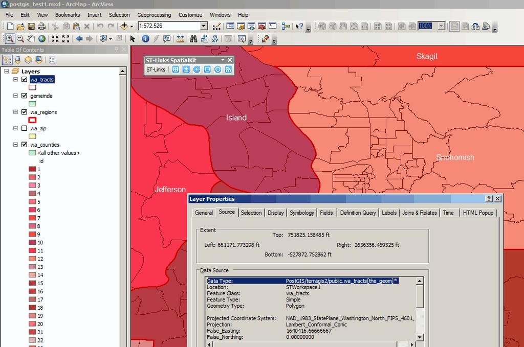
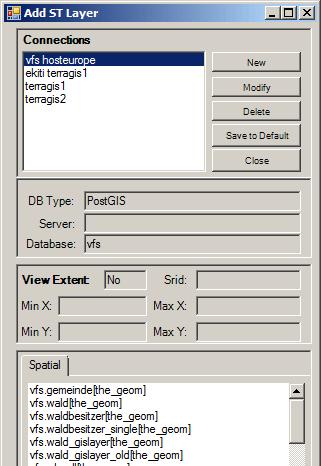
4 SpatialKit for ArcGIS
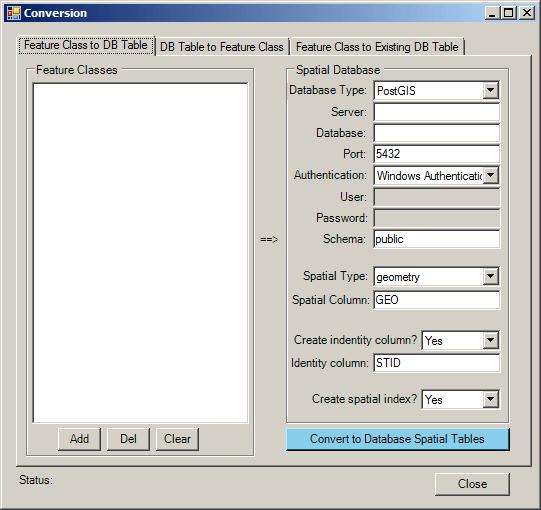
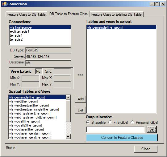
5 Format Conversion SpatialKit for ArcGIS
6 SpatialKit for ArcGIS For the most part SpatialKit seamlessly integrates with ArcMap. But! Restrictions Tips

7 Using Spatial Kit Tips create spatial indexes in PostGIS SpatialKit for ArcGIS Set Map View Extent use ArcGIS definition queries


8 PostGIS spatial database pgadmin GUI base Database administration tool


9 PostGIS spatial database PostGIS tables geometry columns spatial reference table
10 PostGIS spatial database PostGIS - the OS Spatial Database Main supporter Refractions Research PostGIS is an extension for PostgreSQL adds support for geographic objects to PostgreSQL enables PostgreSQL server to be used as a backend spatial database for GIS Spatial operations and analysis simply mean running a (spatial) SQL query in the database Similar functions as SDE and much more.

11 PostGIS Examples PostGIS Functions Spatial SQL
12 PostGIS Examples More spatial operations Buffer Select st_buffer(st_simplify(the_geom, 700), 9000) from wa_counties where name ilike 'King'; Intersect select name from counties where counties.the_geom && (setsrid((makepoint( , )),2285)) and intersects (counties.the_geom,setsrid((makepoint( , )),2285));

13 Example PostGIS in Web mapping Schematic View of the Interoperable Web GIS Web browser Client Side Framework: OpenLayers Client Client Side Scripting (JavaScript/AJAX) Web Server (EC2) Web Servers Servers Mapping Engine: MapServer Spatial Data WMS API Spatial Data local commercial layers e.g. precincts shapefiles Vector files e.g. geocoded voters Spatial DB:PostGIS e.g. Google Yahoo MS Virtual Earth tiled images
14 PostGIS Examples Simple spatial operations Output format select askml(the_geom) from counties2008 where name ilike king ; Human readable geometry select astext(the_geom) from counties where name ilike 'King'; Distance select distance(setsrid((makepoint( , )),2285), setsrid((makepoint( , )),2285)); Transform Select transform((setsrid(makepoint( , ),2285)),4326);
15 PostGIS Examples Aggregate functions - Union of polygons Union all counties of the county polygon data set "us_counties " to create one polygon encompassing the area of the entire US. select st_union(the_geom) into us_border from us_counties This operation unions all individual datasets and groups them by states. select st_union (the_geom), state_name into us_states from us_counties group by state_name;
16 SEXTANTE for ArcGIS Beta! needs: ArcGIS 9.3.1, Java, ArcDesktop Java SDK - included with ArcView version 10, at version separate purchase as ArcEngine SEXTANTE for ArcGIS user manual Sextante Articles
17 Sextante SEXTANTE Web page 625 algorithms!

18 Sextante Installation SEXTANTE For ArcGIS extract to arcgispath\java\lib\ext
19 Sextante Functionality provides tools & toolbox native algorithms access to other libraries SAGA, Grass and R Model Builder Batch processing Programming environment Command Line tools
20 Sextante Restrictions - early release (Beta) Sextante in ArcGIS limitations geoprocessing environment - parameter "Use only selected features Output formats: tif, shape, dbf Extent - SEXTANTE algorithms do not honor the "Processing Extent" setting File overwriting - can cause unpredicted results Geometries - Polygons with holes cannot be created yet by SEXTANTE Model Builder - Certain algorithms will not work properly on the algorithm, due to differences between the semantics of SEXTANTE algorithms and ArcGIS tools. ESRI Document: How to troubleshoot ArcGIS Java Extensions

21 SEXTANTE Toolbox Sextante
22 Sextante Project of the Spanish province of Extremadura Sistema Extremeno de Analisis Territorial Geo-processing tool set - software library more than 280 spatial functions raster and vector processing originally targeted at forestry usage, initially based on SAGA GIS Java based plug-ins for Desktop GIS gvsig and OpenJUMP 1.3 ArcGIS and 10.X
23 gvsig Generalidad Valenciana Conselleria d'infraestructures i Transport project - Spanish Community of Valencia mid range Desktop GIS based on open standards part of gvpontis project vpontis_ingles.pdf
24 Sextante gvsig Association gvsig and Sextante facts

25 gvsig CE Community Edition based on gvsig Community effort many plug-ins integrated Postgis, ArcSDE, Navtable & Sextante, Grass, SAGA
26 Resources Resources Spatial Kit for ArcMap PostGIS - Obe, R.& Hsu, L.(2011): PostGIS in Action. Manning. 492 pages, SEXTANTE Sextante Articles Grass GIS Saga Download presentation

27 gvsig CE (with Sextante)
28 Contact me with questions Karsten Vennemann Seattle, WA, USA Terra GIS offers GIS consulting and training
Karsten Vennemann, Seattle. QGIS Workshop CUGOS Spring Fling 2015
 Karsten Vennemann, Seattle 2015 a very capable and flexible Desktop GIS QGIS QGIS Karsten Workshop Vennemann, Seattle slide 2 of 13 QGIS - Desktop GIS originally a GIS viewing environment QGIS for the
ST-Links. SpatialKit. Version 3.0.x. For ArcMap. ArcMap Extension for Directly Connecting to Spatial Databases. ST-Links Corporation.
 ST-Links SpatialKit For ArcMap Version 3.0.x ArcMap Extension for Directly Connecting to Spatial Databases ST-Links Corporation www.st-links.com 2012 Contents Introduction... 3 Installation... 3 Database
Introduction to ArcGIS Server - Creating and Using GIS Services. Mark Ho Instructor Washington, DC
 Introduction to ArcGIS Server - Creating and Using GIS Services Mark Ho Instructor Washington, DC Technical Workshop Road Map Product overview Building server applications GIS services Developer Help resources
These modules are covered with a brief information and practical in ArcGIS Software and open source software also like QGIS, ILWIS.
 Online GIS Training and training modules covered are: 1. ArcGIS, Analysis, Fundamentals and Implementation 2. ArcGIS Web Data Sharing 3. ArcGIS for Desktop 4. ArcGIS for Server These modules are covered
gvsig a real tool for GIS technicians
 gvsig a real tool for GIS technicians Jorge Gaspar Sanz Salinas jsanz@prodevelop.es International Geodetic Students Meeting 05/05/08 Valencia Agenda of the project OK, but what can gvsig do for me now?
Among various open-source GIS programs, QGIS can be the best suitable option which can be used across partners for reasons outlined below.
 Comparison of Geographic Information Systems (GIS) software As of January 2018, WHO has reached an agreement with ESRI (an international supplier of GIS software) for an unlimited use of ArcGIS Desktop
CalWeedMapper. Mapping the Spread of Invasive Plant Species. Karsten Vennemann. Seattle
 CalWeedMapper Mapping the Spread of Invasive Plant Species Karsten Vennemann Seattle Talk Overview The CalWeedMapper Project this presentation is about the expert online editing tool (part of larger project)
How does ArcGIS Server integrate into an Enterprise Environment? Willy Lynch Mining Industry Specialist ESRI, Denver, Colorado USA
 How does ArcGIS Server integrate into an Enterprise Environment? Willy Lynch Mining Industry Specialist ESRI, Denver, Colorado USA wlynch@esri.com ArcGIS Server Technology Transfer 1 Agenda Who is ESRI?
YYT-C3002 Application Programming in Engineering GIS I. Anas Altartouri Otaniemi
 YYT-C3002 Application Programming in Engineering GIS I Otaniemi Overview: GIS lectures & exercise We will deal with GIS application development in two lectures. Because of the versatility of GIS data models
Introducing ArcGIS Engine
 1 Introducing ArcGIS Engine ESRI ArcGIS Engine is a platform for building custom standalone geographic information system (GIS) applications that support multiple application programming interfaces (APIs),
Introduction to geoprocessing services using SEXTANTE. Víctor Olaya SEXTANTE Geospatial Services
 Introduction to geoprocessing services using SEXTANTE. Víctor Olaya SEXTANTE Geospatial Services Overview Quick introduction to SEXTANTE Client/Server fundamentals Standards for web-based geoservices SEXTANTE
Why GIS & Why Internet GIS?
 Why GIS & Why Internet GIS? The Internet bandwagon Internet mapping (e.g., MapQuest) Location-based services Real-time navigation (e.g., traffic) Real-time service dispatch Business Intelligence Spatial
Environmental Systems Research Institute
 Introduction to ArcGIS ESRI Environmental Systems Research Institute Redlands, California 2 ESRI GIS Development Arc/Info (coverage model) Versions 1-7 from 1980 1999 Arc Macro Language (AML) ArcView (shapefile
GIS Software. Evolution of GIS Software
 GIS Software The geoprocessing engines of GIS Major functions Collect, store, mange, query, analyze and present Key terms Program collections of instructions to manipulate data Package integrated collection
Existing Open Source Tools and Possibilities for Cadastre Systems
 Existing Open Source Tools and Possibilities for Cadastre Systems Gertrude Pieper Espada FIG Congress Sydney, 11-16 April 2010 What is FLOSS? What is open source? What open source software tools are available?
OSGIS Platform. Storing and distributing PostGIS, Deegree, UMN Map Server Desktop visualization JUMP, QGIS, Thuban, udig, gvsig
 GIS groups of tasks Geodata collecting, updating Geodata storing and distributing Geodata analysis Geodata visualization: Desktop, Internet, Printing Geodata describing: metadata management Geodata converting:
GIS CONCEPTS ARCGIS METHODS AND. 3 rd Edition, July David M. Theobald, Ph.D. Warner College of Natural Resources Colorado State University
 GIS CONCEPTS AND ARCGIS METHODS 3 rd Edition, July 2007 David M. Theobald, Ph.D. Warner College of Natural Resources Colorado State University Copyright Copyright 2007 by David M. Theobald. All rights
Free and Open Source Software for Cadastre and Land Registration : A Hidden Treasure? Gertrude Pieper Espada. Overview
 Free and Open Source Software for Cadastre and Land Registration : A Hidden Treasure? Gertrude Pieper Espada Overview FLOSS concepts Digital Land Administration systems FLOSS Database alternatives FLOSS
Introduction to the 176A labs and ArcGIS Purpose of the labs
 Introduction to the 176A labs and ArcGIS Purpose of the labs Acknowledgement: Slides by David Maidment, U Texas-Austin and Francisco Olivera (TAMU) Hands-on experience with a leading software package Introduction
Geodatabase Management Pathway
 Geodatabase Management Pathway Table of Contents ArcGIS Desktop II: Tools and Functionality 3 ArcGIS Desktop III: GIS Workflows and Analysis 6 Building Geodatabases 8 Data Management in the Multiuser Geodatabase
Introduction to ArcGIS Server Development
 Introduction to ArcGIS Server Development Kevin Deege,, Rob Burke, Kelly Hutchins, and Sathya Prasad ESRI Developer Summit 2008 1 Schedule Introduction to ArcGIS Server Rob and Kevin Questions Break 2:15
Introduction to the 176A labs and ArcGIS
 Introduction to the 176A labs and ArcGIS Acknowledgement: Slides by David Maidment, U Texas-Austin and Francisco Olivera (TAMU) Purpose of the labs Hands-on experience with one software pakage Introduction
Valdosta State University Strategic Research & Analysis
 Christopher Neasbitt, Programmer Analyst Associate (cjneasbi@valdosta.edu) Kristina M. Cragg, Ph.D., Assistant to the President for Strategic Research & Analysis (kmcragg@valdosta.edu) Amir Atabekov, Student
INTRODUCTION TO ARCGIS Version 10.*
 Week 3 INTRODUCTION TO ARCGIS Version 10.* topics of the week Overview of ArcGIS Using ArcCatalog Overview of ArcGIS Desktop ArcGIS Overview Scalable desktop applications ArcView ArcEditor ArcInfo ArcGIS
GIS CONCEPTS ARCGIS METHODS AND. 2 nd Edition, July David M. Theobald, Ph.D. Natural Resource Ecology Laboratory Colorado State University
 GIS CONCEPTS AND ARCGIS METHODS 2 nd Edition, July 2005 David M. Theobald, Ph.D. Natural Resource Ecology Laboratory Colorado State University Copyright Copyright 2005 by David M. Theobald. All rights
NR402 GIS Applications in Natural Resources
 NR402 GIS Applications in Natural Resources Lesson 1 Introduction to GIS Eva Strand, University of Idaho Map of the Pacific Northwest from http://www.or.blm.gov/gis/ Welcome to NR402 GIS Applications in
UNIT 4: USING ArcGIS. Instructor: Emmanuel K. Appiah-Adjei (PhD) Department of Geological Engineering KNUST, Kumasi
 Department of Geological Engineering KNUST, Kumasi") UNIT 4: USING ArcGIS Instructor: Emmanuel K. Appiah-Adjei (PhD) Department of Geological Engineering KNUST, Kumasi Getting to Know ArcGIS ArcGIS is an integrated collection of GIS software products ArcGIS
UNIT 4: USING ArcGIS Instructor: Emmanuel K. Appiah-Adjei (PhD) Department of Geological Engineering KNUST, Kumasi Getting to Know ArcGIS ArcGIS is an integrated collection of GIS software products ArcGIS
Arcgis Tutorial Manual READ ONLINE
 Arcgis Tutorial Manual READ ONLINE ArcGIS Desktop 10 Trial Help - Note: The Quick Start Guide contains instructions that do not pertain to the trial edition. Many tutorials are found in the ArcGIS Desktop
The Geo Web: Enabling GIS on the Internet IT4GIS Keith T. Weber, GISP GIS Director ISU GIS Training and Research Center.
 The Geo Web: Enabling GIS on the Internet IT4GIS Keith T. Weber, GISP GIS Director ISU GIS Training and Research Center In the Beginning GIS was independent The GIS analyst or manager was typically a oneperson
December 2009 ArcGIS Server Functionality Matrix
 December 2009 ArcGIS Server 9.3.1 Functionality Matrix ESRI 380 New York St., Redlands, CA 92373-8100 USA TEL 909-793-2853 FAX 909-793-5953 E-MAIL info@esri.com WEB www.esri.com Copyright 2009 ESRI All
Lecture 2. A Review: Geographic Information Systems & ArcGIS Basics
 Lecture 2 A Review: Geographic Information Systems & ArcGIS Basics GIS Overview Types of Maps Symbolization & Classification Map Elements GIS Data Models Coordinate Systems and Projections Scale Geodatabases
PostGIS Cookbook. open source I community experience distilled
 PostGIS Cookbook Over 80 task-based recipes to store, organize, manipulate, and analyze spatial data in a PostGIS database Paolo Corti Thomas J Kraft Stephen Vincent Mather Bborie Park PUBLISHING open
ESRI Technology Overview
 ESRI Technology Overview The ArcGIS 9.2 System & The Road Ahead Katie Clift Chris LeSueur Health GIS Conference 2007 1 Product Architectural Overview Architectural Description & Key Features An integrated
ArcMap - EXPLORING THE DATABASE Part I. SPATIAL DATA FORMATS Part II
 Week 5 ArcMap - EXPLORING THE DATABASE Part I SPATIAL DATA FORMATS Part II topics of the week Exploring the Database More on the Table of Contents Exploration tools Identify, Find, Measure, Map tips, Hyperlink,
Lecture 2. Introduction to ESRI s ArcGIS Desktop and ArcMap
 Lecture 2 Introduction to ESRI s ArcGIS Desktop and ArcMap Outline ESRI What is ArcGIS? ArcGIS Desktop ArcMap Overview Views Layers Attribute Tables Help! Scale Tips and Tricks ESRI Environmental Systems
Esri Overview for Mentor Protégé Program:
 Agenda Passionate About Helping You Succeed Esri Overview for Mentor Protégé Program: Northrop Grumman CSSS Jeff Dawley 3 September 2010 Esri Overview ArcGIS as a System ArcGIS 10 - Map Production - Mobile
Leveraging Your Geo-spatial Data Investments with Quantum GIS: an Open Source Geographic Information System
 Leveraging Your Geo-spatial Data Investments with Quantum GIS: an Open Source Geographic Information System Donald L. Schrupp Colorado Division of Wildlife (Retired) Danny Lewis Texas Parks and Wildlife
GIS Boot Camp for Education June th, 2011 Day 1. Instructor: Sabah Jabbouri Phone: (253) x 4854 Office: TC 136
 x 4854 Office: TC 136") GIS Boot Camp for Education June 27-30 th, 2011 Day 1 Instructor: Sabah Jabbouri Phone: (253) 833-9111 x 4854 Office: TC 136 Email: sjabbouri@greenriver.edu http://www.instruction.greenriver.edu/gis/ Summer
GIS Boot Camp for Education June 27-30 th, 2011 Day 1 Instructor: Sabah Jabbouri Phone: (253) 833-9111 x 4854 Office: TC 136 Email: sjabbouri@greenriver.edu http://www.instruction.greenriver.edu/gis/ Summer
EEOS 381 -Spatial Databases and GIS Applications
 EEOS 381 -Spatial Databases and GIS Applications Lecture 5 Geodatabases What is a Geodatabase? Geographic Database ESRI-coined term A standard RDBMS that stores and manages geographic data A modern object-relational
Overview of Geospatial Open Source Software which is Robust, Feature Rich and Standards Compliant
 Overview of Geospatial Open Source Software which is Robust, Feature Rich and Standards Compliant Cameron SHORTER, Australia Key words: Open Source Geospatial Foundation, OSGeo, Open Standards, Open Geospatial
ArcGIS 10.1 An Overview of the System
 ArcGIS 10.1 An Overview of the System ArcGIS 10.1 An Overview of the System Damian Spangrud Director of Solutions, Esri Redlands, CA USA ArcGIS 10.1 Web Cloud Online Mobile Enterprise Desktop ArcGIS 10.1
Development of Geoweb application using Open Source Technology: An innovative approach for disaster mitigation and management
 Development of Geoweb application using Open Source Technology: An innovative approach for disaster mitigation and management Harish Karnatak harish@iirs.gov.in Reedhi Shukla National Remote Sensing Center
Troubleshooting Replication and Geodata Services. Liz Parrish & Ben Lin
 Troubleshooting Replication and Geodata Services Liz Parrish & Ben Lin AGENDA: Troubleshooting Replication and Geodata Services Overview Demo Troubleshooting Q & A Overview of Replication Liz Parrish What
OPEN SOURCE TECHNOLOGIES IN GEOGRAPHIC INFORMATION SYSTEMS
 GEOGRAPHIC INFORMATION SYSTEMS OPEN SOURCE TECHNOLOGIES IN GEOGRAPHIC INFORMATION SYSTEMS Marijana Petković 1, Vladmir Bulatović 1, Ivan Aleksić 2 1 University of Novi Sad, Faculty of Technical Sciences,
GENERALIZATION IN THE NEW GENERATION OF GIS. Dan Lee ESRI, Inc. 380 New York Street Redlands, CA USA Fax:
 GENERALIZATION IN THE NEW GENERATION OF GIS Dan Lee ESRI, Inc. 380 New York Street Redlands, CA 92373 USA dlee@esri.com Fax: 909-793-5953 Abstract In the research and development of automated map generalization,
Leveraging the GIS Capability within FlexiCadastre
 Managing Local Land Concerns, Maintaining Corporate Governance Leveraging the GIS Capability within FlexiCadastre Regional User Conference, North America May 6 th May 9 th, 2013 Cameron McKellar, Technical
October 2011 ArcGIS 10 for Server Functionality Matrix
 October 2011 ArcGIS 10 for Server Functionality Matrix Esri, 380 New York St., Redlands, CA 92373-8100 USA TEL 909-793-2853 FAX 909-793-5953 E-MAIL info@esri.com WEB www.esri.com Copyright 2011 Esri All
Selecting the optimal opensource GIS software for local authorities by combining the ISO 9126 standard and AHP approach
 Selecting the optimal opensource GIS software for local authorities by combining the ISO 9126 standard and AHP approach D. Jankovic * and R. Milidragovic ** * Municipality Trebinje, Trebinje, Bosnia and
A Distributed GIS Architecture for Research in Baalbek Based on CISAR
 234 Frank Henze A Distributed GIS Architecture for Research in Baalbek Based on CISAR Abstract: Research underway in Baalbek extends from the immediate vicinity of the excavation areas to the monumental
Geodatabase 101 Why, What, & How
 Geodatabase 101 Why, What, & How Beau Dealy Dealy Geomatics, LC beau@dealygeo.com Curt Moore InfiniTec, Inc. cmoore@infinitec.net ... first, a brief explanation. Geodata traditionally stored as two components
Enabling ENVI. ArcGIS for Server
 Enabling ENVI throughh ArcGIS for Server 1 Imagery: A Unique and Valuable Source of Data Imagery is not just a base map, but a layer of rich information that can address problems faced by GIS users. >
A. Boluwade 1 and A Ferdinand. Ste Anne de Bellevue, QC, H9X 3V9, Canada. ABSTRACT
 The Design and Development of Spatial Database Management Systems (SDMS) for Hydrographic Studies using coupled Open-Source GIS and Relational Database A. Boluwade 1 and A Ferdinand 1 Department Bioresource
IndiFrag v2.1: An Object-based Fragmentation Analysis Software Tool
 IndiFrag v2.1: An Object-based Fragmentation Analysis Software Tool Geo-Environmental Cartography and Remote Sensing Group http://cgat.webs.upv.es/software/ Universitat Politècnica de València Introduction
Exelis and Esri Technologies for Defense and National Security. Cherie Muleh
 Exelis and Esri Technologies for Defense and National Security Cherie Muleh Cherie.Muleh@exelisinc.com ENVI IMAGERY AND DATA BECOME KNOWLEDGE > Add information from imagery to your GIS > Automated workflows
Welcome to NR502 GIS Applications in Natural Resources. You can take this course for 1 or 2 credits. There is also an option for 3 credits.
 Welcome to NR502 GIS Applications in Natural Resources. You can take this course for 1 or 2 credits. There is also an option for 3 credits. The 1st credit consists of a series of readings, demonstration,
Newcastle City Council - Migration to QGIS and Open Source GIS
 Newcastle City Council - Migration to QGIS and Open Source GIS Brian Williams & Saber Razmjooei 13 April 2016 Outline I Why Open Source? Rational What we did How we did it Benefits Discussion Points QGIS
Outline. Chapter 1. A history of products. What is ArcGIS? What is GIS? Some GIS applications Introducing the ArcGIS products How does GIS work?
 Outline Chapter 1 Introducing ArcGIS What is GIS? Some GIS applications Introducing the ArcGIS products How does GIS work? Basic data formats The ArcCatalog interface 1-1 1-2 A history of products Arc/Info
Data Aggregation with InfraWorks and ArcGIS for Visualization, Analysis, and Planning
 Data Aggregation with InfraWorks and ArcGIS for Visualization, Analysis, and Planning Stephen Brockwell President, Brockwell IT Consulting, Inc. Join the conversation #AU2017 KEYWORD Class Summary Silos
Geometric Algorithms in GIS
 Geometric Algorithms in GIS GIS Visualization Software Dr. M. Gavrilova GIS Software for Visualization ArcView GEO/SQL Digital Atmosphere AutoDesk Visual_Data GeoMedia GeoExpress CAVE? Visualization in
Exploring PostGIS with a Full Analysis Example
 Exploring PostGIS with a Full Analysis Example J.C. MARTINEZ, E. COLL, J. IRIGOYEN Department of Cartographic Engineering, Geodesy and Photogrammetry Polytechnic University of Valencia Camino de Vera,
The PREVIEW Global Risk Data Platform: a geoportal to serve and share global data on risk to natural hazards
 The PREVIEW Global Risk Data Platform: a geoportal to serve and share global data on risk to natural hazards Gregory Giuliani (UNEP/GRID-Geneva & University of Geneva/enviroSPACE ) http://www.grid.unep.ch
GIS at JLAB. T. Larrieu Jefferson Lab, Newport News, VA 23606, USA. Controls Group. October 2006 PCaPAC
 GIS at JLAB T. Larrieu Jefferson Lab, Newport News, VA 23606, USA October 2006 PCaPAC Jefferson Lab has a Large and Complex Infrastructure CEBAF ( 24/7 electron utility ) 7 km of beamline 2000+ magnets
GIS Data Production and Editing Pathway
 GIS Data Production and Editing Pathway Table of Contents ArcGIS Desktop II: Tools and Functionality 3 ArcGIS Desktop III: GIS Workflows and Analysis 6 Building Geodatabases 8 Creating and Maintaining
ArcGIS Runtime: Migrating from ArcGIS Engine. Rex Hansen
 ArcGIS Runtime: Migrating from ArcGIS Engine Rex Hansen Thank You to Our Sponsors Migrating from ArcGIS Engine to ArcGIS Runtime ArcGIS Runtime API: new and evolved workflows on all platforms Windows Linux
GTK GeoKernel and Data Management. Material from Niina Ahtonen, Esa Kauniskangas and Tero Rönkkö
 GTK GeoKernel and Data Management Esa Kauniskangas 31.5.2010 Material from Niina Ahtonen, Esa Kauniskangas and Tero Rönkkö 1 GTK s operational areas Northern Finland Office Rovaniemi Western Finland Office
The File Geodatabase API. Craig Gillgrass Lance Shipman
 The File Geodatabase API Craig Gillgrass Lance Shipman Schedule Cell phones and pagers Please complete the session survey we take your feedback very seriously! Overview File Geodatabase API - Introduction
GIS for ChEs Introduction to Geographic Information Systems
 GIS for ChEs Introduction to Geographic Information Systems AIChE Webinar John Cirucci 1 GIS for ChEs Introduction to Geographic Information Systems What is GIS? Tools and Methods Applications Examples
ArcGIS. for Server. Understanding our World
 ArcGIS for Server Understanding our World ArcGIS for Server Create, Distribute, and Manage GIS Services You can use ArcGIS for Server to create services from your mapping and geographic information system
Lecture 2. Introduction to GIS Software and Resources
 Lecture 2 Introduction to GIS Software and Resources GIS in Water Resources Spring 2015 Introduction to GIS Software there are others. Proprietary: 1 Introduction to GIS Software and even more. OpenSource:
Practical teaching of GIS at University of Liège
 Practical teaching of GIS at University of Liège Jean-Paul Kasprzyk, assistant Lessons Pr. Jean-Paul Donnay: For non-geographers (geologists, urban planners, engineers ) GIS users Master: Introduction
ArcGIS Pro Q&A Session. NWGIS Conference, October 11, 2017 With John Sharrard, Esri GIS Solutions Engineer
 ArcGIS Pro Q&A Session NWGIS Conference, October 11, 2017 With John Sharrard, Esri GIS Solutions Engineer jsharrard@esri.com ArcGIS Desktop The applications ArcGIS Pro ArcMap ArcCatalog ArcScene ArcGlobe
2010 NORTH TEXAS GIS TOPIC SURVEY
 21 NORTH TEXAS GIS TOPIC SURVEY PARTICIPATING ORGANIZATIONS ESRI (Environmental Systems Research Institute) NCTCOG (North Central Texas Council of Governments) NCTGITA (North Central Texas Geospatial Information
Salisbury University: Eric Flint, John O Brien, & Alex Nohe
 Salisbury University: Eric Flint, John O Brien, & Alex Nohe Open Source (Public) Geographic Information System GNU General Public License Guarantees public s ability to download, modify and share software
Converting workflows from ArcSDE Command line in ArcGIS 10.3.x
 Best Practices for Converting workflows from ArcSDE Command line in ArcGIS 10.3.x Melissa Jarman & George Thompson Esri Support Services Summary of Session History Going forward New tools Why migrate?
Pierre Racine Research Assistant Centre for Forest Research Département des sciences du bois et de la forêt, Université Laval, Québec
 Pierre Racine Research Assistant Centre for Forest Research Département des sciences du bois et de la forêt, Université Laval, Québec Steve Cumming Researcher Centre for Forest Research Département des
Cross Comparison of Spatially Enabled Databases: PostGIS, SQL Server and JASPA
 of Spatially Enabled Databases: PostGIS, SQL Server and JASPA Leo Hsu and Regina Obe http://www.postgis.us http://www.bostongis.com http://www.postgresonline.com http://www.paragoncorporation.com Key Focus
GEOGRAPHIC INFORMATION SYSTEMS AND WATER RESOURCES IV AWRA SPRING SPECIALTY CONFERENCE Houston, Texas
 GEOGRAPHIC INFORMATION SYSTEMS AND WATER RESOURCES IV AWRA SPRING SPECIALTY CONFERENCE Houston, Texas May 8-10, 2006 Copyright 2006, AWRA THE BASINS WATERSHED ANALYSIS SYSTEM -- INTEGRATING WITH OPEN SOURCE
ESRI Object Models and Data Capture 9/18/ /18/2014 M. Helper GEO327G/386G, UT Austin 2. ESRI Arc/Info ArcView ArcGIS
 ESRI Object Models; Data Capture Conceptual Models Conceptual Models Characterized all features or phenomena as: Feature Class (spatial table) Number Age_Ma 1_sigma Rx_Type 123 142 1.5 B_schist 124 136
Leveraging Web GIS: An Introduction to the ArcGIS portal
 Leveraging Web GIS: An Introduction to the ArcGIS portal Derek Law Product Management DLaw@esri.com Agenda Web GIS pattern Product overview Installation and deployment Configuration options Security options
GIS-based Computational Tools & Techniques for Multidimensional Data Analysis & Visualization
 GIS-based Computational Tools & Techniques for Multidimensional Data Analysis & Visualization Sanjay Srivas 1 and Dr. P. G. Khot 2 1 Research Scholar, Dept. of Electronics & Information Technology, RTM
A Geographer s role in a Google Maps World. Jeremy Bartley ESRI
 A Geographer s role in a Google Maps World Jeremy Bartley ESRI 1 It is a good time to be a Geographer. 2 Microsoft, Google, Yahoo, and others are pushing geographic awareness to the general public Providing
How to Pick a GIS. GIS Software Chapter 8 in Longley, Goodchild, Maguire, and Rhind,, 2001
 How to Pick a GIS GIS Software Chapter 8 in Longley, Goodchild, Maguire, and Rhind,, 2001 How to Pick a GIS Evolution of GIS software Architecture of GIS software Types of software Example products The
Geog 469 GIS Workshop. Managing Enterprise GIS Geodatabases
 Geog 469 GIS Workshop Managing Enterprise GIS Geodatabases Outline 1. Why is a geodatabase important for GIS? 2. What is the architecture of a geodatabase? 3. How can we compare and contrast three types
ESRI Survey Summit August Clint Brown Director of ESRI Software Products
 ESRI Survey Summit August 2006 Clint Brown Director of ESRI Software Products Cadastral Fabric How does Cadastral fit with Survey? Surveyors process raw field observations Survey measurements define high-order
No. of Days. ArcGIS 3: Performing Analysis ,431. Building 3D cities Using Esri City Engine ,859
 What s New? Creating Story Maps with ArcGIS Field Data Collection and Management Using ArcGIS Get Started with Insights for ArcGIS Introduction to GIS Using ArcGIS & ArcGIS Pro: Essential Workflow Migrating
No. of Days. ArcGIS Pro for GIS Professionals ,431. Building 3D cities Using Esri City Engine ,859
 What s New? Creating Story Maps with ArcGIS Field Data Collection and Management Using ArcGIS Get Started with Insights for ArcGIS Introduction to GIS Using ArcGIS & ArcGIS Pro: Essential Workflow Migrating
Open Source Technologies and Remotely Sensed Data in Protecting Elephants. Rosemary Alles Dr. Justine Blanford Penn State World Campus July 2015
 Open Source Technologies and Remotely Sensed Data in Protecting Elephants Rosemary Alles Dr. Justine Blanford Penn State World Campus July 2015 Global Crisis: Poaching & Wildlife Trafficking 100,000 Elephants
Generating Scheduled Rasters using Python
 Generating Scheduled Rasters using Python Kevin B. Cary, GISP Department of Geography and Geology Western Kentucky University 1906 College Heights Blvd #31066 Bowling Green, KY 42101 1066 July 2, 2015
GPS Mapping with Esri s Collector App. What We ll Cover
 GPS Mapping with Esri s Collector App Part 1: Overview What We ll Cover Part 1: Overview and requirements Part 2: Preparing the data in ArcGIS for Desktop Part 3: Build a web map in ArcGIS Online Part
GIS Functions and Integration. Tyler Pauley Associate Consultant
 GIS Functions and Integration Tyler Pauley Associate Consultant Contents GIS in AgileAssets products Displaying data within AMS Symbolizing the map display Display on Bing Maps Demo- Displaying a map in
Geospatial Products V8i (SELECTseries 1)
") Geospatial Products V8i (SELECTseries 1) Keith Raymond Product Manager Geospatial Desktop Products Presentation Overview What are the various products? Why would you need them? Demonstrations 2 WWW.BENTLEY.COM
Geospatial Products V8i (SELECTseries 1) Keith Raymond Product Manager Geospatial Desktop Products Presentation Overview What are the various products? Why would you need them? Demonstrations 2 WWW.BENTLEY.COM
ESRI Object Models and Data Capture 2/1/2018
 Number 123 124 125 ESRI* Object Models; Data Capture Feature Class (spatial table) Age_Ma 142 136 1_sigma 1.5 2.0 Rx_Type B_schist G_schist Object Class (nonspatial table) Size_kg 3.4 1.3 Y Control Point
McGill University, Ste Anne de Bellevue, QC, H9X 3V9, Canada. 2 University of Juame I, Castellon, Spain.
 The Design and Development of Spatial Database Management Systems (SDMS) for Hydrographic Studies using Coupled Open-Source GIS and Relational Database. Alaba Boluwade, M.Sc. *1 and Andrew Ferdinand M.Sc.
Using the File Geodatabase API. Lance Shipman David Sousa
 Using the File Geodatabase API Lance Shipman David Sousa Overview File Geodatabase API - Introduction - Supported Tasks - API Overview - What s not supported - Updates - Demo File Geodatabase API Provide
POSITION DESCRIPTION. Position Title: Geographic Information Systems (GIS) Coordinator Department: Engineering
 Coordinator Department: Engineering") POSITION DESCRIPTION Position Title: Geographic Information Systems (GIS) Coordinator Department: Engineering Reports To: Engineering Supervisor FLSA Status: Exempt Date: April 2018 PRIMARY OBJECTIVE OF
POSITION DESCRIPTION Position Title: Geographic Information Systems (GIS) Coordinator Department: Engineering Reports To: Engineering Supervisor FLSA Status: Exempt Date: April 2018 PRIMARY OBJECTIVE OF
GIS for Business Intelligence: Getting Cloud Connected
 GIS for Business Intelligence: Getting Cloud Connected Ed Farrell Director of GIS Solutions, DVG efarrell@dvginteractive.com http://dvginteractive.com October 19 th, 2017 Lake Placid Convention Center
Map Services Are We Getting It?
 Map Services Are We Getting It? Rich Herrmann VP Global Platforms & Technology, IHS James Sanders Senior Product Manager, IHS April 19, 2011 Houston, TX USA Overview The Challenge Keith Fraley s 2010 PUG
Portal for ArcGIS: An Introduction. Catherine Hynes and Derek Law
 Portal for ArcGIS: An Introduction Catherine Hynes and Derek Law Agenda Web GIS pattern Product overview Installation and deployment Configuration options Security options and groups Portal for ArcGIS
ESRI GUIDE TO GIS ANALYSIS
 page 1 / 5 page 2 / 5 esri guide to gis pdf ESRI Shapefile Technical Description J-7855 March 1998 2 SDE, ARC/INFO, PC ARC/INFO, Data Automation Kit (DAK ), and ArcCAD software provide shape-to-coverage
ESRI educational site license in Bahir Dar University. Tegegn Molla Abebe Mengaw Geospatial Data and Technology Center, BDU
 ESRI educational site license in Bahir Dar University Tegegn Molla Abebe Mengaw Geospatial Data and Technology Center, BDU September, 2016 Mission, Vision Purpose and Values of the GDTC Mission of GDTC