Map Projections. Chapter 3. Emmanuel Stefanakis
|
|
|
- Kerrie Lynette Anthony
- 5 years ago
- Views:
Transcription
1 Stefanakis, E., Geographic Databases and Information Systems. CreateSpace Independent Publ. [In English], pp.386. Get a copy from Amazon Chapter 3 Map Projections Emmanuel Stefanakis
2 Map Projections A function f φ λ (Χ,Υ) ƒ(φ, λ) Y X 2

3 Errors in Maps The Earth (Mercator Projection) In reality Africa is 14 times China is 4 times larger than Greenland 3
4 Errors in Maps The Earth (Mercator Projection) In reality countries in the South are double in area than countries in the North 4


5 Which is the right shape? 5


6 Which is the right shape? 6
7 From the Sphere to the Plane Earth is almost spherical How? The map is planar 7

8 From the Sphere to the Plane Earth is almost spherical How? It is not possible to make the sphere planar! The map is planar 8

9 From the Sphere to the Plane If the earth was a cylinder 9

10 From the Sphere to the Plane If the earth was a cylinder How? It is possible to make the cylinder planar! 10


11 From the Sphere to the Plane How about the sphere? 11


12 From the Sphere to the Plane Use an intermediate surface (projective surface) 12
13 Projection Surfaces Tangent cases 13
14 Projection Surfaces 14
15 A Simulation of the process 15

16 A Cylindrical Projection 16
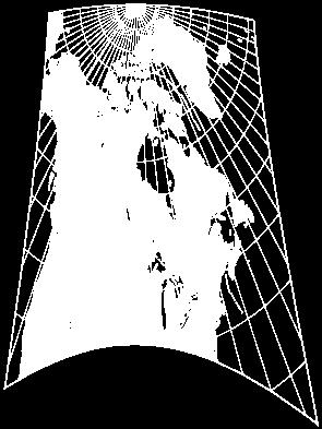
17 An Azimuthal Projection 17
18 A Conical Projection 18

19 The distribution of Errors 19
20 Distortions a circle on sphere equal area equal shape equal distance the projected image 20
21 Another configuration Secant cases 21
22 Another configuration 22
23 Another configuration orthogonal transversal oblique 23
24 Select the right projection 24


25 Select the right projection What about France Canada Turkey Chile 25
26 Map Projections The notion of scale 1:K 26
27 Common Projections Gnomonic Projection meridians parallels R tan(90 - φ ) parallel R 90 - φ φ projection center 27
28 Common Projections Gnomonic Projection meridians parallels parallel parallel radius Scale distortions along the meridians latitude Scale factor on meridian projection center Scale distortions along the parallels latitude 75 Scale factor on parallel
29 Common Projections Stereographic Projection meridians parallels parallel equator projection center parallel radius Shifts the projection center to the opposite pole (further) to minimize the distortions. 29
30 Common Projections Stereographic Projection meridians parallels parallel radius 2R tan[(90 - φ )/2] parallel parallel R 90 - φ φ equator [90 - φ]/2 projection center projection center 30
31 Common Projections Gnomonic (vs) Stereographic Projection R tan(90 - φ ) 2R tan[(90 - φ )/2] parallel R 90 - φ φ parallel R 90 - φ φ projection center [90 - φ]/2 projection center 31
32 Common Projections Gnomonic Projection Great Circles Straight Lines (!) projection of the great circle projection plane (map) great circle projection center 32
33 Common Projections Gnomonic Projection Great Circles Straight Lines (!)» Shortest path Florida Bristol 33
34 Common Projections Conical Projections r r 2π - α meridian parallel 34
35 Common Projections Conical Projections α = 2π sinφ r = R cotφ φ r 2π-α R φ 35
36 Common Projections Equidistant Conical Projections r s north pole radius s s North pole meridian parallel 36

37 Common Projections Equidistant Conical Projections 37
38 Common Projections Cylindrical Projections North pole equator South pole 38
39 Common Projections Mercator Projection 39
40 Common Projections Mercator Projection Distortion of Areas in Mercator Projection for a small area in latitude factor of area distortion
41 Cylindrical Projection 41
42 Cylindrical Projection 2πRcos(φ) < 2πR R cos(φ) φ 2πR φ R λ 42
43 Cylindrical Projection 2πRcos(φ) < 2πR 2πR φ 2πR 2πR λ Y X 43

44 Common Projections Mercator Projection 2πR 2πR 44
45 Mercator s goal: preserve shapes Scale factor on horizontal (along parallels at φ): 2πRcos(φ) 2πR 45
46 Mercator s goal: preserve shapes Scale factor on horizontal (along parallels at φ): 2πRcos(φ) 2πR Scale factor on vertical (along meridians at φ): 2πRcos(φ) 2πR 46
47 Common Projections Mercator Projection Preserves the directions All parallels have the same length = equator (2πR) At latitude φ the scale factor on the parallel is equal to: 2π R 2π Rcosφ secφ 47
48 Common Projections Mercator Projection Preserves the directions (shapes) Mercator applied the same factor on the meridians The actual distance between two parallels at latitude φ is equal to: dy = R dφ He made it equal to: dy = R secφ dφ 48
49 Common Projections Mercator Projection Preserves the directions (shapes) By integrating the last formula we get: φ o φ Y R secφ dφ Rlntan North pole Υ φ equator South pole 2π R 49
50 Loxodrome ΒΠ N Α θ θ θ θ θ Β Κ ισημερινός equator S
51 Common Projections Mercator Projection The loxodromes are straight lines(!) The shortest paths are curves though 51
52 Stefanakis, E., Geographic Databases and Information Systems. CreateSpace Independent Publ. [In English], pp.386. Get a copy from Amazon Chapter 3 Map Projections Emmanuel Stefanakis
Map projections. Rüdiger Gens
 Rüdiger Gens 2 Outline! Relevant terms! Why map projections?! Map projection categories " Projection surfaces " Features preserved from distortions! Map projection examples! Right choice Relevant terms!
Map projections. Rüdiger Gens
 Rüdiger Gens Coordinate systems Geographic coordinates f a: semi-major axis b: semi-minor axis Geographic latitude b Geodetic latitude a f: flattening = (a-b)/a Expresses as a fraction 1/f = about 300
Georeferencing. datum. projection. scale. The next few lectures will introduce you to these elements. on the Earth, you ll need to understand how
 Georeferencing GOAL: To assign a location to all the features represented in our geographic information data In order to do so, we need to make use of the following elements: ellipsoid/geoid To determine
Web Mercator Projection & Raster Tile Maps
 Web Mercator Projection & Raster Tile Maps Annual Conference 2017 Ottawa May 31- June 2, 2017 Two cornerstones of Online Map Service Providers Emmanuel Stefanakis Dept. of Geodesy & Geomatics Engineering
Plane coordinates ~~~~~~~~~~
 Coordinate Systems & Map Projections Geographic coordinates A Basic Introduction to Coordinate Systems & Map Projections Latitude & longitude Angles Parallels & meridians Lines Plane coordinates ~~~~~~~~~~
Map Projections 2/4/2013. Map Projections. Rhumb Line (Loxodrome) Great Circle. The GLOBE. Line of constant bearing (e.g., 292.
 Great Circle. The GLOBE. Line of constant bearing (e.g., 292.") The GLOBE ADVANTAGES Directions True Distances True Shapes True Area True DISADVANTAGES Very small scale with little detail. Costly to reproduce and update. Difficult to carry around. Bulky to store. FACTS
The GLOBE ADVANTAGES Directions True Distances True Shapes True Area True DISADVANTAGES Very small scale with little detail. Costly to reproduce and update. Difficult to carry around. Bulky to store. FACTS
Map Projections & Coordinate Systems
 Map Projections & Coordinate Systems 9/7/2017 1 Why? Laying the Earth Flat Need convenient means of measuring and comparing distances, directions, areas, shapes. Traditional surveying instruments measure
What is a Map Projection?
 What is a Map Projection? It is how we represent a three dimensional Earth on a flat piece of paper However The process of transferring information from the Earth to a map causes every projection to distort
Map Projections. Displaying the earth on 2 dimensional maps
 Map Projections Displaying the earth on 2 dimensional maps Map projections Define the spatial relationship between locations on earth and their relative locations on a flat map Are mathematical expressions
Outline. Shape of the Earth. Geographic Coordinates (φ, λ, z) Ellipsoid or Spheroid Rotate an ellipse around an axis. Ellipse.
 Ellipsoid or Spheroid Rotate an ellipse around an axis. Ellipse.") Map Projections Outline Geodesy and map projections Prof. D. Nagesh Kumar Department of Civil Engineering Indian Institute of Science Bangalore 560 012, India http://www.civil.iisc.ernet.in/~nagesh Shape
Map Projections Outline Geodesy and map projections Prof. D. Nagesh Kumar Department of Civil Engineering Indian Institute of Science Bangalore 560 012, India http://www.civil.iisc.ernet.in/~nagesh Shape
MAP PROJECTIONS but before let s review some basic concepts.
 MAP PROJECTIONS but before let s review some basic concepts. Types of Maps General Purpose Topographic Thematic/Choropleth Dot Graduated Circle Isometric/Isolines Isopleth Mental Maps Scale Small-scale
Map Projections (Part 1)
") 1 Earth is a round, maps are not. Four projection families. Equivalent (Equal Area) projections Preserves relative areas Commonly used for thematic maps Ex: Albers Conformal projections Preserve angles,
1 Earth is a round, maps are not. Four projection families. Equivalent (Equal Area) projections Preserves relative areas Commonly used for thematic maps Ex: Albers Conformal projections Preserve angles,
Geographic coordinate systems
 1 Geographic coordinate systems In this chapter you ll learn about longitude and latitude. You ll also learn about the parts that comprise a geographic coordinate system including Spheres and spheroids
Introduction to Cartography GEOG 2016 E. Lecture-2 Geodesy and Projections
 Introduction to Cartography GEOG 2016 E Lecture-2 Geodesy and Projections What is Geodesy? The science of geodesy determines: Earth s shape and Interrelation of different points on earth s surface The
The Mathematics of Maps Lecture 4. Dennis The The Mathematics of Maps Lecture 4 1/29
 The Mathematics of Maps Lecture 4 Dennis The The Mathematics of Maps Lecture 4 1/29 Mercator projection Dennis The The Mathematics of Maps Lecture 4 2/29 The Mercator projection (1569) Dennis The The Mathematics
Projections Part I - Categories and Properties James R. Clynch February 2006
 I. Introduction and References Projections Part I - Categories and Properties James R. Clynch February 2006 The world is, approximately, a sphere. Maps are flat. Making maps requires some method of putting
GIST 3300 / Geographic Information Systems. Last Time. Today
 GIST 3300 / 5300 Last Time Ellipsoids and Datums Today Map Projections Map Projections Today we will build on the concepts of Geographic Coordinate Systems, Ellipsoids and Datums and add the concepts of
WHERE ARE YOU? Maps & Geospatial Concepts Fall 2015
 WHERE ARE YOU? Maps & Geospatial Concepts Fall 2015 Where are you? Relative location I m at school Absolute Location 45 26 18.07 122 43 50.78 Where is Boston? Introducing Geodesy, Ellipsoids & Geoids Geodesy
How can we project a 3D globe onto a 2D display? - Ellipsoids and Datums deal with earth non-sphericity
 Map projections How can we project a 3D globe onto a 2D display? - Ellipsoids and Datums deal with earth non-sphericity http://www.mapovasbirka.cz/english/index_eng.html The world could be mapped like
Map Projections. Chapter 4 MAP PROJECTION
 Map Projections Chapter 4 Map Projections What is map projection? Why are map projections drawn? What are the different types of projections? Which projection is most suitably used for which area? In this
WHERE ARE YOU? Maps & Geospatial Concepts Fall 2012
 WHERE ARE YOU? Maps & Geospatial Concepts Fall 2012 Where are you? Relative location I m at school Absolute Location 45 26 18.07 122 43 50.78 Datums Datums A reference surface of the Earth Used as the
Map Projections & Coordinate Systems 9/10/2013. Why? M. Helper GEO327G/386G, UT Austin 2. M. Helper GEO327G/386G, UT Austin 4
 Map Projections & Coordinates Laing the earth flat Wh? Need convenient means of measuring and comparing distances, directions, areas, shapes. Traditional surveing instruments measure in meters or feet,
Modern Navigation. Thomas Herring
 12.215 Modern Navigation Thomas Herring Today s class Map Projections: Why projections are needed Types of map projections Classification by type of projection Classification by characteristics of projection
Map Projections & Coordinate Systems 9/7/2017
 Map Projections & Coordinate Sstems Laing the Earth Flat Wh? Need convenient means of measuring and comparing distances, directions, areas, shapes. Traditional surveing instruments measure in meters or
Georeferencing, Map Projections, Cartographic Concepts. -Coordinate Systems -Datum
 Georeferencing, Map Projections, Cartographic Concepts -Map Projections -Coordinate Systems -Datum Map projection is "the process of systematically transforming positions on the Earth's spherical surface
Shape e o f f the e Earth
 1 Coordinate Systems & Projections Coordinate Systems Two map layers are not going to register spatially unless they are based on the same coordinate system. 2 Contents Shape of the earth Datum Projections
Working with georeferenced data. What is georeferencing? Coordinate Systems. Geographic and Projected Coordinate System
 GIS501 Fundamentals of Geographical Information Systems (GIS) Coordinate Systems Working with georeferenced data What is georeferencing? Geographically referenced data which is, in some way, referenced
Introduction to Geographic Information Science. Updates/News. Last Lecture. Geography 4103 / Map Projections and Coordinate Systems
 Geography 4103 / 5103 Introduction to Geographic Information Science Map Projections and Coordinate Systems Updates/News Thursday s lecture Reading discussion 1 find the readings online open questions,
Welcome to Lesson 4. It is important for a GIS analyst to have a thorough understanding of map projections and coordinate systems.
 Welcome to Lesson 4. It is important for a GIS analyst to have a thorough understanding of map projections and coordinate systems. A GIS without coordinates would simply be a database like Microsoft Excel
Projections and Coordinate Systems
 Projections and Coordinate Systems Overview Projections Examples of different projections Coordinate systems Datums Projections Overview Projections and Coordinate Systems GIS must accurately represent
Notes on Projections Part II - Common Projections James R. Clynch February 2006
 Notes on Projections Part II - Common Projections James R. Clynch February 2006 I. Common Projections There are several areas where maps are commonly used and a few projections dominate these fields. An
Maps: Geography s Basic Tools
 Maps: Geography s Basic Tools What is a map? - A map is a representation of the earth s features drawn on a flat surface. - Maps use points, lines, colours, and symbols to represent the features of an
Applied Cartography and Introduction to GIS GEOG 2017 EL. Lecture-1 Chapters 1 and 2
 Applied Cartography and Introduction to GIS GEOG 2017 EL Lecture-1 Chapters 1 and 2 What is GIS? A Geographic Information System (GIS) is a computer system for capturing, storing, querying, analyzing and
Navigation. Longitude and Latitude Foundations of Navigation. MTPs:
 Navigation 3.01 Foundations of Navigation References: FTGU pages 177-178, 184-190 Transport Canada Study and Reference Guide Glider Pilot Canada Flight Training Manual Pilot Navigation http://en.wikipedia.org/wiki/transverse_mercator_projection#spherical_transverse_mercator
Map Projections. Which ones best suit your needs?
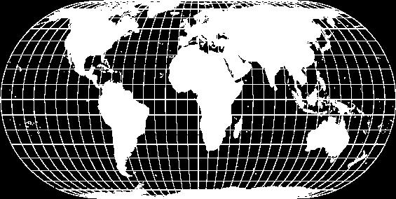
 1 z 21 2010-02-20 18:38 Map Projections The Globe Mercator Transverse Mercator Oblique Mercator Space Oblique Mercator Miller Cylindrical Robinson Sinusoidal Equal Area Orthographic Stereographic Gnomonic
Chapter 3 Models of the Earth. 3.1 Finding Locations on the Earth. 3.1 Objectives
 Chapter 3 Models of the Earth 3.1 Finding Locations on the Earth 3.1 Objectives Explain latitude and longitude. How can latitude and longitude be used to find locations on Earth? How can a magnetic compass
Map Projections & Coordinate Systems 1/25/2018
 Map Projections & Coordinate Sstems Laing the Earth Flat How? Projections transformation of curved earth to a flat map; sstematic rendering of the lat. & lon. graticule to rectangular coordinate sstem.
Importance of Understanding Coordinate Systems and Map Projections.
 Importance of Understanding Coordinate Systems and Map Projections. 1 It is extremely important that you gain an understanding of coordinate systems and map projections. GIS works with spatial data, and,
Integrals in cylindrical, spherical coordinates (Sect. 15.7)
") Integrals in clindrical, spherical coordinates (Sect. 15.7 Integration in spherical coordinates. Review: Clindrical coordinates. Spherical coordinates in space. Triple integral in spherical coordinates.
Integrals in clindrical, spherical coordinates (Sect. 15.7 Integration in spherical coordinates. Review: Clindrical coordinates. Spherical coordinates in space. Triple integral in spherical coordinates.
Coordinate Systems. Location on earth is defined by coordinates
 Coordinate Systems We think of the earth as a sphere It is actually a spheroid (ellipsoid), slightly larger in radius at the equator than at the poles Shape of the Earth Location on earth is defined by
Introduction to Geoinformatics I
 Introduction to Geoinformatics I MAP CONCEPT Definition: 1) A map is a visual representation of an area a symbolic depiction highlighting relationships between elements of that space such as objects, regions,
NR402 GIS Applications in Natural Resources Lesson 4 Map Projections
 NR402 GIS Applications in Natural Resources Lesson 4 Map Projections From http://www.or.blm.gov/gis/ 1 Geographic coordinates Coordinates are expressed as Latitude and Longitude in Degrees, Minutes, Seconds
The Sphere of the Earth Activities
 The Sphere of the Earth Activities December 20, 2012 Daniel Ramos MMACA (Museu de Matemàtiques de Catalunya) These activities are designed to be done with the materials, posters and software of the exhibit
Lesson 5: Map Scale and Projections
 Organizing Data and Information Lesson 5: Map Scale and Projections Map Scales Projections Information can be organized as lists, numbers, tables, text, pictures, maps, or indexes. Clusters of information
Georeferencing. Place names Postal addresses Postal codes Coordinate systems (lat/long, UTM, etc.)
") Georeferencing Georeferencing Used to describe the act of assigning locations to data or information Certain requirements include that they are: unique, have shared meaning, and are persistent through
Georeferencing Georeferencing Used to describe the act of assigning locations to data or information Certain requirements include that they are: unique, have shared meaning, and are persistent through
Map Projections. What does the world look like? AITOFF AZIMUTHAL EQUIDISTANT BEHRMANN EQUAL AREA CYLINDRICAL
 Map Projections What does the world look like? AITOFF AZIMUTHAL EQUIDISTANT BEHRMANN EQUAL AREA CYLINDRICAL 1 CYLINDRICAL EQUAL AREA BONNE CRASTER PARABOLIC 2 ECKERT I ECKERT III ECKERT V There are many
Lecture 2. Map Projections and GIS Coordinate Systems. Tomislav Sapic GIS Technologist Faculty of Natural Resources Management Lakehead University
 Lecture 2 Map Projections and GIS Coordinate Systems Tomislav Sapic GIS Technologist Faculty of Natural Resources Management Lakehead University Map Projections Map projections are mathematical formulas
The due date for submitting this assignment has passed. As per our records you have not submitted this. Both statement 1 and statement 2 are true
 X reviewer3@nptel.iitm.ac.in Courses» Higher Surveying Unit 4 - Week 2 Announcements Course Ask a Question Progress Mentor FAQ Course outline How to access the portal Week 0 Week 1 Week 2 Quiz : Assignment
Referencing map features: Coordinate systems and map projections
 Referencing map features: Coordinate systems and map projections Coordinate systems and map projections if we want to integrate geographic data from many different sources, we need to use a consistent
Reference Coordinate Systems (3/3)
") Reference Coordinate Systems (3/3) José E. Sanguino I Instituto de elecomunicações Instituto Superior écnico, v. Rovisco Pais, 049-00 Lisboa, Portugal el: +35.848468, Fax: +35.84847, Email: sanguino@lx.it.pt
Reference Coordinate Systems (3/3) José E. Sanguino I Instituto de elecomunicações Instituto Superior écnico, v. Rovisco Pais, 049-00 Lisboa, Portugal el: +35.848468, Fax: +35.84847, Email: sanguino@lx.it.pt
The Wildlife Society Meet and Greet. Come learn about what the UNBC Student Chapter of TWS is all about!
 Georeferencing I GEOG 300, Lecture 4 Dr. Anthony Jjumba 1 The Wildlife Society Meet and Greet Quiz Come learn about what the UNBC Student Chapter of TWS is all about! 5:30 7:30 PM, Wednesday September
THE EARTH AND ITS REPRESENTATION
 UNIT 7 THE EARTH AND ITS REPRESENTATION TABLE OF CONTENTS 1 THE EARTH AND THE SOLAR SYSTEM... 2 2 THE EARTH S MOVEMENTS... 2 2.1 Rotation.... 2 2.2 The revolution of the Earth: seasons of the year....
Spatial Data, 16 th Century Dutchmen, GPS and GIS. Martin Charlton, National Centre for Geocomputation National University of Ireland Maynooth
 Spatial Data, 16 th Century Dutchmen, GPS and GIS Martin Charlton, National Centre for Geocomputation National University of Ireland Maynooth Maps as truth Maps are cultural artifacts, comparable in history
1. Geospatial technology rarely links geospatial data to nonspatial data. a. True *b. False
 Chapter 2 Where in the Geospatial World Are You? 1. Geospatial technology rarely links geospatial data to nonspatial data. 2. For geospatial technology to work, every location on Earth must be: a. inhabited
EnvSci360 Computer and Analytical Cartography
 EnvSci360 Computer and Analytical Cartography Lecture 3 Geodesy Map Projections, Datums, and Coordinate Systems 1 Geodesy The science of measuring and representing the shape and size of the earth, and
Mobile Systeme Grundlagen und Anwendungen standortbezogener Dienste. Location Based Services in the Context of Web 2.0
 Mobile Systeme Grundlagen und Anwendungen standortbezogener Dienste Location Based Services in the Context of Web 2.0 Department of Informatics - MIN Faculty - University of Hamburg Lecture Summer Term
Spatial Reference Systems. Introduction
 Spatial Reference Systems Wolfgang Kainz Professor of Cartography and Geoinformation Department of Geography and Regional Research University of Vienna wolfgang.kainz@univie.ac.at Introduction Historic
Lab #3 Map Projections.
 Lab #3 Map Projections http://visual.merriam-webster.com/images/earth/geography/cartography/map-projections.jpg Map Projections Projection: a systematic arrangement of parallels and meridians on a plane
Dr. ABOLGHASEM AKBARI Faculty of Civil Engineering & Earth Resources, University Malaysia Pahang (UMP)
") Workshop on : Dr. ABOLGHASEM AKBARI Faculty of Civil Engineering & Earth Resources, University Malaysia Pahang (UMP) 14-15 April 2016 Venue: Tehran, Iran GIS definitions GIS: A simplified view of the real
Workshop on : Dr. ABOLGHASEM AKBARI Faculty of Civil Engineering & Earth Resources, University Malaysia Pahang (UMP) 14-15 April 2016 Venue: Tehran, Iran GIS definitions GIS: A simplified view of the real
the Cartesian coordinate system (which we normally use), in which we characterize points by two coordinates (x, y) and
, in which we characterize points by two coordinates (x, y) and") 2.5.2 Standard coordinate systems in R 2 and R Similarly as for functions of one variable, integrals of functions of two or three variables may become simpler when changing coordinates in an appropriate
2.5.2 Standard coordinate systems in R 2 and R Similarly as for functions of one variable, integrals of functions of two or three variables may become simpler when changing coordinates in an appropriate
Choosing a Suitable Projection for Navigation in the Arctic
 Choosing a Suitable Projection for Navigation in the Arctic Dr. Andriani Skopeliti, Prof. Lysandros Tsoulos Cartography Laboratory, School of Rural and Surveying Engineering, National Technical University
ch02.pdf chap2.pdf chap02.pdf
 Introduction to Geographic Information Systems 8th Edition Karl Solutions Manual Full Download: http://testbanklive.com/download/introduction-to-geographic-information-systems-8th-edition-karl-solutions-manu
History of Cartography,
 Maps History of Cartography, the art and science of making maps ~2300 BC ~600 BC Early oldest known maps: Babylonian clay tablets. Greek and Roman Ptolemy s (about AD 85-165) "world map" depicted the Old
The Elements of GIS. Organizing Data and Information. The GIS Database. MAP and ATRIBUTE INFORMATION
 GIS s Roots in Cartography Getting Started With GIS Chapter 2 Dursun Z. Seker MAP and ATRIBUTE INFORMATION Data (numbers and text) store as files refer to them collectively as a database gather inform.
1/28/16. EGM101 Skills Toolbox. Oblate spheroid. The shape of the earth Co-ordinate systems Map projections. Geoid
 EGM101 Skills Toolbox Oblate spheroid The shape of the earth Co-ordinate systems Map projections The geoid is the shape that the surface of the oceans would take under the influence of Earth's gravitation
12/26/2012. Geographic Information Systems * * * * GIS (... yrezaei
 ( - Geographic Information Systems ( ( 1 2 3 Information System Data base DB IS IS DB (Knowledge ( ( (System (Information System - (Georefrence Analysis Data + Knowledge ======== Information 4 5 ( < 10%
Geo Referencing & Map projections CGI-GIRS 0910
 Geo Referencing & Map projections CGI-GIRS 0910 Where are you? 31UFT8361 174,7 441,2 51 58' NB 5 40' OL 2/60 Who are they? 3/60 Do geo data describe Earth s phenomena perfectly? Georeference systems ellipsoid
Metamathematics of Elementary Mathematics Lecture 5 Navigation on the Riemann Sphere
 Metamathematics of Elementary Mathematics Lecture 5 Navigation on the Riemann Sphere Alexandre Borovik based on ideas of Hovik Khudaverdyan Nesin Mathematics Village Şirince, 26 Jul 2008 1 A heroic era
This week s topics. Week 6. FE 257. GIS and Forest Engineering Applications. Week 6
 FE 257. GIS and Forest Engineering Applications Week 6 Week 6 Last week Chapter 8 Combining and splitting landscape features and merging GIS databases Chapter 11 Overlay processes Questions? Next week
GMT TECHNICAL REFERENCE & COOKBOOK Azimuthal Projections Lambert Azimuthal Equal-Area ( Ja or JA)
") GMT TECHNICAL REFERENCE & COOKBOOK 5 7 5.3 Azimuthal Projections 5.3.1 Lambert Azimuthal Equal-Area ( Ja or JA) This projection was developed by Lambert in 1772 and is typically used for mapping large
GMT TECHNICAL REFERENCE & COOKBOOK 5 7 5.3 Azimuthal Projections 5.3.1 Lambert Azimuthal Equal-Area ( Ja or JA) This projection was developed by Lambert in 1772 and is typically used for mapping large
2. GETTING STARTED WITH GIS
 2. GETTING STARTED WITH GIS What are geographic information systems and what are they used for? ArcGIS: ArcMap, ArcCatalog and ArcToolbox Vector data vs. raster data vs. attribute tables Polygons, polylines,
GLOBES VERSUS FLAT MAPS
 3 Map projections A map projection is a geometrical transformation of the earth's spherical or ellipsoidal surface onto a flat map surface. Much has been written about map projections, yet people still
Dirty REMOTE SENSING : Lecture 8 A mapping interlude..
 Dirty REMOTE SENSING : Lecture 8 A mapping interlude.. Stuart Green Teagasc Spatial Analysis Group Stuart.green@teagasc.ie Web for the Week: http://electronics.howstuffworks.com/gps.htm http://www.cstars.ucdavis.edu/classes/ers186-w03/lecture17/lecture17.ppt
Coordinate Systems and Datum Transformation in ArcGIS. Brittney White and Melita Kennedy
 Coordinate Systems and Datum Transformation in ArcGIS Brittney White and Melita Kennedy Where is my data? Problem Horizontal Vertical Projections Transformations Horizontal coordinate systems Geographic
A map is a small-scale flat-surface representation of some portion of the earth s surface.
 MAPS AND CHARTS A map is a small-scale flat-surface representation of some portion of the earth s surface. A representation that is designed for plotting navigational information is called a chart. Often
How does an ellipsoid differ from a sphere in approximating the shape and size of the Earth?
 Chapter 02 Test Bank Worksheet Questions 1. What is a map projection? Topic: Map Projection 2. How does an ellipsoid differ from a sphere in approximating the shape and size of the Earth? Topic: Ellipsoid
Lecture 10-14: Map Projections and Coordinate System
 URP 1281 Surveying and Cartography Lecture 10-14: Map Projections and Coordinate System December 27, 2015 Course Teacher: Md. Esraz-Ul-Zannat Assistant Professor Department of Urban and Regional Planning
DOWNLOAD PDF MERCATOR WORLD MAP WITH COORDINATE LINES
 Chapter 1 : Detailed World Map Mercator Europe-Africa One Stop Map World Coordinate Map Mercator Projection =This Mercator projection map can be configured to display just the navigational coordinate attributes
Some of these parallels are very important. In the Northern Hemisphere, there is the Tropic of Cancer and the Arctic Circle.
 PDF 2 Geographic coordinates 1 The geographic coordinates system is network of imaginary horizontal and vertical lines that are drawn on globes or maps. These lines are called parallels (lines of latitude)
Data acquisition and integration 1.
 Data acquisition and integration 1. Ferenc Végső Data acquisition and integration 1.: Ferenc Végső Lector: Árpád Barsi This module was created within TÁMOP - 4.1.2-08/1/A-2009-0027 "Tananyagfejlesztéssel
Map Projections. is about presenting the round Earth on a flat surface.map Projections: Vermeer s Cartographer
 Map Projections is about presenting the round Earth on a flat surface.map Projections: Vermeer s Cartographer What is a map projection? A projection is a way to make a flat representation of the Earth
Part IB GEOMETRY (Lent 2016): Example Sheet 1
: Example Sheet 1") Part IB GEOMETRY (Lent 2016): Example Sheet 1 (a.g.kovalev@dpmms.cam.ac.uk) 1. Suppose that H is a hyperplane in Euclidean n-space R n defined by u x = c for some unit vector u and constant c. The reflection
Part IB GEOMETRY (Lent 2016): Example Sheet 1 (a.g.kovalev@dpmms.cam.ac.uk) 1. Suppose that H is a hyperplane in Euclidean n-space R n defined by u x = c for some unit vector u and constant c. The reflection
Geo Referencing & Map projections CGI-GIRS 0910
 Geo Referencing & Map projections CGI-GIRS 0910 Where are you? 31UFT8361 174,7 441,2 51 58' NB 5 40' OL 2/60 Who are they? 3/60 Do geo data describe Earth s phenomena perfectly? Georeference systems ellipsoid
Theory of Knowledge Lesson One:!!! The Map is not the Territory. One of the key questions of/for this course is:!!!! How do we know?
 Theory of Knowledge 3813 Lesson One:!!! The Map is not the Territory One of the key questions of/for this course is:!!!! How do we know? Two of the key components of/for this course are:!!!! OPEN MIND!!!!
Math 396. Map making
 Math 396. Map making 1. Motivation When a cartographer makes a map of part of the surface of the earth, this amounts to choosing a C isomorphism from a 2-submanifold with corners S in the sphere S 2 (r)
Data acquisition and integration 1.
 University of West Hungary, Faculty of Geoinformatics Ferenc Végső Data acquisition and integration 1. module DAI1 The basics of positioning SZÉKESFEHÉRVÁR 2010 The right to this intellectual property
What is a map? A Map is a two or three-dimensional model or representation of the Earth s surface. 2-Dimensional map
 What is a map? A Map is a two or three-dimensional model or representation of the Earth s surface. 2-Dimensional map What is a Map Projection? Planar Projection Projection A Projection is a mathematical
Fri. Jan. 26, Demonstration of QGIS with GPS tracks. Types of data, simple vector (shapefile) formats
 formats") Fri. Jan. 26, 2018 Demonstration of QGIS with GPS tracks Types of data, simple vector (shapefile) formats Map projections, Coordinate Reference Systems Demonstration of QGIS with geologic map 1 Raster
Fri. Jan. 26, 2018 Demonstration of QGIS with GPS tracks Types of data, simple vector (shapefile) formats Map projections, Coordinate Reference Systems Demonstration of QGIS with geologic map 1 Raster
Math 461 Homework 8. Paul Hacking. November 27, 2018
 Math 461 Homework 8 Paul Hacking November 27, 2018 (1) Let S 2 = {(x, y, z) x 2 + y 2 + z 2 = 1} R 3 be the sphere with center the origin and radius 1. Let N = (0, 0, 1) S 2 be the north pole. Let F :
Math 461 Homework 8 Paul Hacking November 27, 2018
 (1) Let Math 461 Homework 8 Paul Hacking November 27, 2018 S 2 = {(x, y, z) x 2 +y 2 +z 2 = 1} R 3 be the sphere with center the origin and radius 1. Let N = (0, 0, 1) S 2 be the north pole. Let F : S
CANONICAL EQUATIONS. Application to the study of the equilibrium of flexible filaments and brachistochrone curves. By A.
 Équations canoniques. Application a la recherche de l équilibre des fils flexibles et des courbes brachystochrones, Mem. Acad. Sci de Toulouse (8) 7 (885), 545-570. CANONICAL EQUATIONS Application to the
ArcGIS for Applied Economists Session 2
 ArcGIS for Applied Economists Session 2 Mark Westcott LMU Munich June 15, 2015 1 / 31 Topics for this session: Geographic Coordinate Systems Projections Projected Coordinate Systems Geocoding 2 / 31 Some
REFERENCING COORDINATE SYSTEMS MAP PROJECTIONS GEOREFERENCING
 GIS in Ecology SPATIAL REFERENCING COORDINATE SYSTEMS MAP PROJECTIONS GEOREFERENCING : :1 Where on earth? Early mapmakers recognized the need for a system that could locate features on the earth's surface.
Math Review for Exam Compute the second degree Taylor polynomials about (0, 0) of the following functions: (a) f(x, y) = e 2x 3y.
 of the following functions: (a) f(x, y) = e 2x 3y.") Math 35 - Review for Exam 1. Compute the second degree Taylor polynomial of f e x+3y about (, ). Solution. A computation shows that f x(, ), f y(, ) 3, f xx(, ) 4, f yy(, ) 9, f xy(, ) 6. The second degree
Math 35 - Review for Exam 1. Compute the second degree Taylor polynomial of f e x+3y about (, ). Solution. A computation shows that f x(, ), f y(, ) 3, f xx(, ) 4, f yy(, ) 9, f xy(, ) 6. The second degree
Practice Final Solutions
 Practice Final Solutions Math 1, Fall 17 Problem 1. Find a parameterization for the given curve, including bounds on the parameter t. Part a) The ellipse in R whose major axis has endpoints, ) and 6, )
European Petroleum Survey Group EPSG. Guidance Note Number 7
 European Petroleum Survey Group EPSG Guidance Note Number 7 POSC literature pertaining to Coordinate Conversions and Transformations including Formulas This information was compiled by EPSG members for
Analytical and Computer Cartography Lecture 3: Review: Coordinate Systems
 Analytical and Computer Cartography Lecture 3: Review: Coordinate Systems Geographic Coordinates NAD83 NAD27 remained in use until the earthcentered international GRS80 was complete (Geodetic Reference
A Prototype of a Web Mapping System Architecture for the Arctic Region
 A Prototype of a Web Mapping System Architecture for the Arctic Region Han-Fang Tsai 1, Chih-Yuan Huang 2, and Steve Liang 3 GeoSensorWeb Laboratory, Department of Geomatics Engineering, University of
CARIS Geomatics Reference Guide
 CARIS Geomatics Reference Guide CARIS (Global Headquarters) 115 Waggoners Lane Fredericton, NB Canada E3B 2L4 Phone: 1 (506) 458-8533 (English/French/Spanish) Fax: 1 (506) 459-3849 Email: info@caris.com
2. What does the map scale tell the map reader? a ratio between the actual distance on the ground and the length given to that distance on a map
 AP Human Geography - Damon Name Unit 1 - Intro to Human Geography Hour Map and Globe Skills Review Note: All links in this packet are found on our Wikispace under Map and Globe Skills Review First, read