Web Mercator Projection & Raster Tile Maps
|
|
|
- Lora Griselda Wilkerson
- 6 years ago
- Views:
Transcription


1 Web Mercator Projection & Raster Tile Maps Annual Conference 2017 Ottawa May 31- June 2, 2017 Two cornerstones of Online Map Service Providers Emmanuel Stefanakis Dept. of Geodesy & Geomatics Engineering University of New Brunswick


2 Online Map Service Providers O Available for ~12 years O Well established (difficult to remember how life was without them) 2


3 Online Map Service Providers 3

4 Online Map Service Providers Challenges? Technological Cartographical 4


5 Online Map Service Providers Framework Request (where/what/resolution) CLIENT HTTP Map Product SERVER Map Service End-users Map Repository (Data+Images) 5


6 Technological Challenges O High and steadily increasing demand O Voluminous data (vectors and images) O Bandwidth limitations O Concurrent access O Security issues O Data protection 6
7 Cartographical Challenges O Visualize the map on Web browser O flat/rectangular monitor O Multi-resolution representation O various zoom levels O Multi-theme mapping O various themes (layers) O Multi-language mapping O various languages 7
8 Online Map Service Providers Web Mercator Projection Raster Tile Maps 8
 CLIENT")

9 Map Product Flat Monitor Request (where/what/resolution) CLIENT HTTP Map Product SERVER Map Service Map Repository (Data+Images) 9
10 Map Projection O A function f... φ λ (Χ,Υ) ƒ(φ, λ) Y X 10

11 Choose a Map Projection 11
12 Choose a Cylindrical O Best fit O Rectangular grid 12
13 Conical Projection? 13
14 Conical Projection? 14

15 Cylindrical Projection? 15
16 Cylindrical Projection O Simulation of a cylindrical projection 16

17 Cylindrical Projection O Simulation of a cylindrical projection 17


18 Which Cylindrical? Plate Carree Miller s Mercator 18
 O to serve high demand")
19 Mercator Projection O Most popular O Conformal O Easy math (low complexity) O to serve high demand 19
 < 2πR 2πR φ 2πR 2πR λ Y X")
20 Mercator Projection O Conformal O Support navigation in Seas πRcos(φ) < 2πR 2πR φ 2πR 2πR λ Y X 20

21 Mercator Projection 2πR 2πR 21
22 Mercator Projection Scale factor on horizontal (along parallels at φ): 2πRcos(φ) 2πR Mercator s goal preserve shapes/directions 22
23 Mercator Projection Scale factor on horizontal (along parallels at φ): 2πRcos(φ) 2πR Mercator applied Scale factor on vertical (along meridians at φ): 2πRcos(φ) 2πR 23
24 Mercator Projection All parallels have the same length = equator (2πR) φ At latitude φ the scale factor on the parallel is equal to: 2π R 2π Rcosφ secφ 24
25 Mercator Projection φ 2 dn φ 1 Mercator applied the same factor on the parallels The actual distance between two parallels at latitude φ is equal to: dn = R dφ He made it equal to: dn = R secφ dφ 25
26 Mercator Projection By integrating the last formula we get: (sphere) N φ o φ R secφ dφ Rlntan North pole N φ equator South pole 2π R 26
 Northing P(E s, N s ) Spherical Formulas Sphere")
27 Mercator Projection O Spherical Formulas Easting P(φ s, λ s ) Northing P(E s, N s ) Spherical Formulas Sphere 27
28 Mercator Projection O Ellipsoidal Formulas Easting Northing P(φ e, λ e ) P(E e, N e ) Ellipsoidal Formulas WGS 84 28
29 Mercator Projection O Spherical Formulas Easting Northing Easting O Ellipsoidal Formulas Northing 29
30 Adopt Mercator Projection Request (where/what/resolution) CLIENT HTTP SERVER Map Product Map Service O O Ellipsoid Coordinates Mercator Projection Map Repository (Data+Images) 30
31 Web Mercator O Make it even less computational expensive O P(φ e, λ e ) Ellipsoid Coordinates Spherical Formulas P(E, N) P(φ s, λ s ) WGS 84 Spherical Formulas Web Mercator Sphere 31
32 Online Map Service Providers Web Mercator Projection 32
33 Web Mercator (vs) Mercator O Mercator basic properties are lost O Non-Conformal O Loxodromes Not straight lines O Rationale (Google) O Simpler calculations O Map to be projected on a computer monitor O No body can notice the differences 33
34 34
35 Criticism O Geodesy Subcommittee of the Oil and Gas Producers (aka EPSG) rejected it in 2008 as technically flawed & an inappropriate geodesy and cartography O National Geospatial-Intelligence Agency of the US Department of Defense declared it as unacceptable for any official use, because a general lack of understanding of its properties has caused considerable confusion and misuse 35
36 A Code for Web Mercator O An unofficial code (GOOGLE spelled with numbers) was initially assigned O Later, EPSG introduced an official identifier: EPSG: WGS84 Web Mercator (Auxiliary Sphere) 36
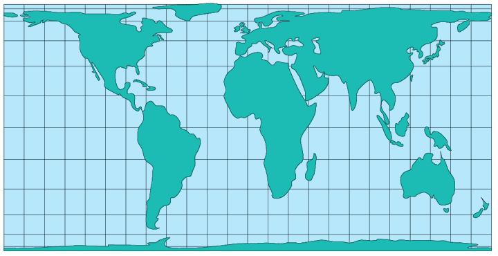
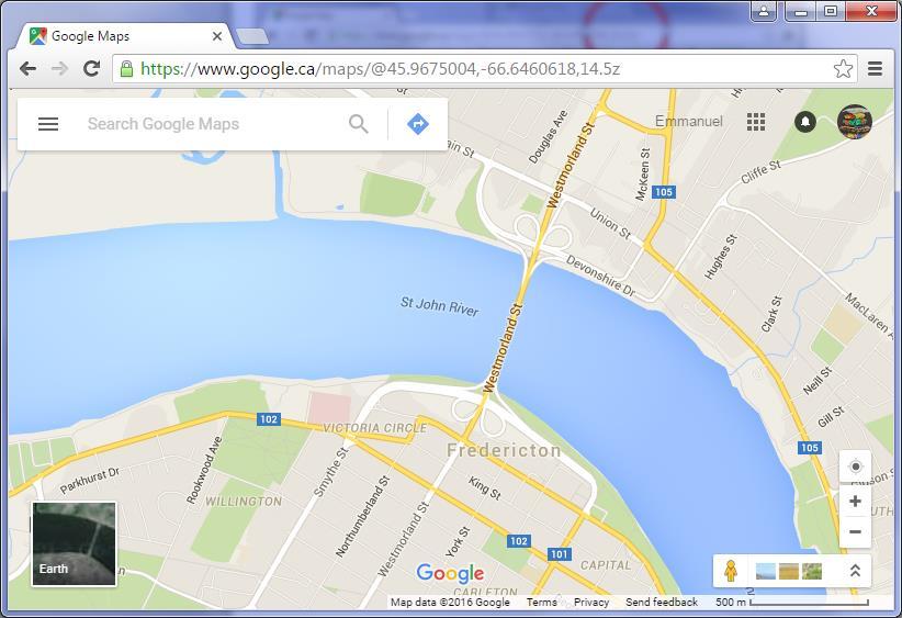
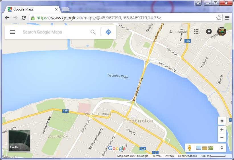
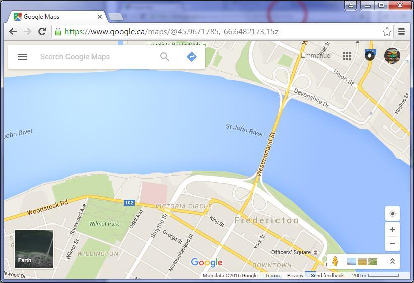
37 40,075, Web Mercator Map of the World O Absolute square North O Very convenient in panning, tiling, and indexing South 40,075,
38 Online Map Service Providers Challenges? Technological Cartographical 38
39 How to deliver the map product? Request (where/what/resolution) CLIENT HTTP Map Product SERVER Map Service Map Repository (Data+Images) 39
40 How to deliver the map product? One map? SERVER Map Service Map Repository (Data+Images) Web Mercator 40
41 How to deliver the map product? One map? SERVER Map Service Map Repository (Data+Images) Web Mercator Map product: Various areas 41
 Web Mercator Map")
42 How to deliver the map product? One map? SERVER Map Service Map Repository (Data+Images) Web Mercator Map product: Various resolution 42


43 How to deliver the map product? One map? SERVER Map Service Web Mercator Map Repository (Data+Images) Map product: Various theme Various language 43

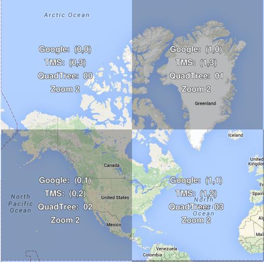
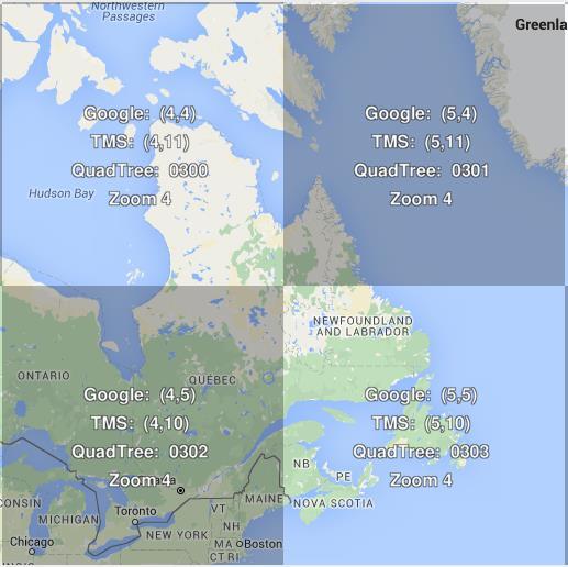
44 One map? Multiple themes Multiple Languages SERVER On-the-fly rendering? Map Service Map Repository (Data+Images) 44

45 On-the-fly generalization? 45
46 Use of Map Tiles Request (where/what/resolution) CLIENT One map not an option HTTP Map Product SERVER Map Service Preprocessing generation of map tiles Map Repository (Data+Images) 46
47 Online Map Service Providers Raster Tile Maps 47
48 Use of Map Tiles Request (where/what/resolution) CLIENT HTTP SERVER Map Product Preprocessing generation of tiles Map Service Map Repository (Data+Images) 48
49 Tiled maps O A series of precompiled maps O for various areas O in various resolutions Map Repository (Data+Images) 49
50 Tiled maps An old practice O Old practice O Sheet Division and Organization of Topographic maps Map Repository (Data+Images) 50

51 Sheet Division & Organization O Topographic Maps 51


52 Sheet Division & Organization O NRCan: National Topographic Map Index 52

53 Web Mapping Tiled Maps O Web mapping O rapid growth of map data availability O rapid growth of demand O Use of map tiles (slippy maps) O pre-computation and caching of map image tiles O map servers use far fewer resources than maps rendered on demand O delivery only limited by the bandwidth of the connection with the map server 53
54 Tiled Maps O Google O was the first major mapping provider to adopt the tiled web maps O Others followed O Bing and OpenStreetMap, Esri and Oracle O provide functionality for map tiling and caching of vector layers and/or raster images 54
55 Google Maps O Conventions O All map tiles O Square-shaped and equal-sized O 256x256 pixels O World rendered in a single tile at the outer most zoom level: 0 O Projection: Web Mercator O latitude values [ , ] degrees 55
56 Google Maps column row x y 0,0 0,0 1,0 0,0 1,0 0,1 1,1 2,0 3,0 2,1 3,1 0,1 1,1 0,2 1,2 2,2 3,2 0,3 1,3 2,3 3,3 Zoom Level: 0 Number of Tiles: 1 Zoom Level: 1 Number of Tiles: 4 Zoom Level: 2 Number of Tiles: 16 56

57 Bing Maps O Quadtree encoding: Quadkeys 57

58 Google Maps Zoom Level [0-24] 58
59 59


60 to Zoom Level

61 #Tiles & Pixel size / Zoom Level Each tile: 256x256 pixels LEVEL TILES/LEVEL Pixel Size (m) , , , , , ,024 4, ,096 2, ,384 1, , , ,048, ,194, ,777, ,108, ,435, ,073,741, ,294,967, ,179,869, ,719,476, ,877,906, ,099,511,627, ,398,046,511, ,592,186,044, ,368,744,177, ,474,976,710, ^ LEVEL 2πR/(256*2^LEVEL) GRS80 (eq) Circumference (2πR) 6,378, m 40,075, m 61

62 Map Tile Management Kotsollaris, M., A Scalable Web Tiled Map Management System. MScE Thesis. University of New Brunswick. 62

63 Interoperability across multiple Map Providers 63
64 Online Map Service Providers Web Mercator Projection Raster Tile Maps 64
65 References O O O O Stefanakis, E., Web Mercator: the de facto standard, the controversy, and the opportunity. GoGeomatics. Magazine of GoGeomatics Canada. October Stefanakis, E., Map Tiles and Cached Map Services. GoGeomatics. Magazine of GoGeomatics Canada. December MapTiler. Tiles à la Google Maps: Coordinates, Tile Bounds and Projection. Tilesets: Google Maps Structure MicroImages. glemapsstruc.pdf 65
Map Projections. Chapter 3. Emmanuel Stefanakis
 Stefanakis, E., 2014. Geographic Databases and Information Systems. CreateSpace Independent Publ. [In English], pp.386. Get a copy from Amazon Chapter 3 Map Projections Emmanuel Stefanakis http://www2.unb.ca/~estef/
EnvSci360 Computer and Analytical Cartography
 EnvSci360 Computer and Analytical Cartography Lecture 3 Geodesy Map Projections, Datums, and Coordinate Systems 1 Geodesy The science of measuring and representing the shape and size of the earth, and
A Prototype of a Web Mapping System Architecture for the Arctic Region
 A Prototype of a Web Mapping System Architecture for the Arctic Region Han-Fang Tsai 1, Chih-Yuan Huang 2, and Steve Liang 3 GeoSensorWeb Laboratory, Department of Geomatics Engineering, University of
Generating and Caching 3D-Tiles for Large-Scale 3D-Visualization GeoSharing , Bern, Switzerland
 Generating and Caching 3D-Tiles for Large-Scale 3D-Visualization GeoSharing 02.11.2013, Bern, Switzerland Martin Christen, Robert Wüest, Benjamin Loesch, Stephan Nebiker FHNW University of Applied Sciences
Lecture 2. Map Projections and GIS Coordinate Systems. Tomislav Sapic GIS Technologist Faculty of Natural Resources Management Lakehead University
 Lecture 2 Map Projections and GIS Coordinate Systems Tomislav Sapic GIS Technologist Faculty of Natural Resources Management Lakehead University Map Projections Map projections are mathematical formulas
REFERENCING COORDINATE SYSTEMS MAP PROJECTIONS GEOREFERENCING
 GIS in Ecology SPATIAL REFERENCING COORDINATE SYSTEMS MAP PROJECTIONS GEOREFERENCING : :1 Where on earth? Early mapmakers recognized the need for a system that could locate features on the earth's surface.
Introduction to Cartography GEOG 2016 E. Lecture-2 Geodesy and Projections
 Introduction to Cartography GEOG 2016 E Lecture-2 Geodesy and Projections What is Geodesy? The science of geodesy determines: Earth s shape and Interrelation of different points on earth s surface The
Map projections. Rüdiger Gens
 Rüdiger Gens Coordinate systems Geographic coordinates f a: semi-major axis b: semi-minor axis Geographic latitude b Geodetic latitude a f: flattening = (a-b)/a Expresses as a fraction 1/f = about 300
Lesson 5: Map Scale and Projections
 Organizing Data and Information Lesson 5: Map Scale and Projections Map Scales Projections Information can be organized as lists, numbers, tables, text, pictures, maps, or indexes. Clusters of information
5 Coordinate Reference Systems
 5 Coordinate Reference Systems 5.1 Overview The INSPIRE theme Coordinate reference systems (CRS) provides a harmonised specification for uniquely referencing spatial information, either using three-dimensional,
Georeferencing, Map Projections, Cartographic Concepts. -Coordinate Systems -Datum
 Georeferencing, Map Projections, Cartographic Concepts -Map Projections -Coordinate Systems -Datum Map projection is "the process of systematically transforming positions on the Earth's spherical surface
Map Projections (Part 1)
") 1 Earth is a round, maps are not. Four projection families. Equivalent (Equal Area) projections Preserves relative areas Commonly used for thematic maps Ex: Albers Conformal projections Preserve angles,
1 Earth is a round, maps are not. Four projection families. Equivalent (Equal Area) projections Preserves relative areas Commonly used for thematic maps Ex: Albers Conformal projections Preserve angles,
This week s topics. Week 6. FE 257. GIS and Forest Engineering Applications. Week 6
 FE 257. GIS and Forest Engineering Applications Week 6 Week 6 Last week Chapter 8 Combining and splitting landscape features and merging GIS databases Chapter 11 Overlay processes Questions? Next week
1/28/16. EGM101 Skills Toolbox. Oblate spheroid. The shape of the earth Co-ordinate systems Map projections. Geoid
 EGM101 Skills Toolbox Oblate spheroid The shape of the earth Co-ordinate systems Map projections The geoid is the shape that the surface of the oceans would take under the influence of Earth's gravitation
WHERE ARE YOU? Maps & Geospatial Concepts Fall 2012
 WHERE ARE YOU? Maps & Geospatial Concepts Fall 2012 Where are you? Relative location I m at school Absolute Location 45 26 18.07 122 43 50.78 Datums Datums A reference surface of the Earth Used as the
WHERE ARE YOU? Maps & Geospatial Concepts Fall 2015
 WHERE ARE YOU? Maps & Geospatial Concepts Fall 2015 Where are you? Relative location I m at school Absolute Location 45 26 18.07 122 43 50.78 Where is Boston? Introducing Geodesy, Ellipsoids & Geoids Geodesy
Map projections. Rüdiger Gens
 Rüdiger Gens 2 Outline! Relevant terms! Why map projections?! Map projection categories " Projection surfaces " Features preserved from distortions! Map projection examples! Right choice Relevant terms!
Map Projections. Displaying the earth on 2 dimensional maps
 Map Projections Displaying the earth on 2 dimensional maps Map projections Define the spatial relationship between locations on earth and their relative locations on a flat map Are mathematical expressions
Understanding Projections for GIS
 Presented by John Schaeffer Juniper GIS Services, Inc. This PowerPoint is available at JuniperGIS.com Presentation Objectives To understand basic concepts on projections and coordinate systems for the
Outline. Shape of the Earth. Geographic Coordinates (φ, λ, z) Ellipsoid or Spheroid Rotate an ellipse around an axis. Ellipse.
 Ellipsoid or Spheroid Rotate an ellipse around an axis. Ellipse.") Map Projections Outline Geodesy and map projections Prof. D. Nagesh Kumar Department of Civil Engineering Indian Institute of Science Bangalore 560 012, India http://www.civil.iisc.ernet.in/~nagesh Shape
Map Projections Outline Geodesy and map projections Prof. D. Nagesh Kumar Department of Civil Engineering Indian Institute of Science Bangalore 560 012, India http://www.civil.iisc.ernet.in/~nagesh Shape
Intro to GIS Fall 2010 Georeferencing & Map Projections
 Intro to GIS Fall 2010 Georeferencing & Map Projections SHAPE OF THE EARTH Earth's Shape Geoid: shape of earth minus topographic features (irregular due to local variations in gravity) Ellipsoid: elongated
Projections & GIS Data Collection: An Overview
 Projections & GIS Data Collection: An Overview Projections Primary data capture Secondary data capture Data transfer Capturing attribute data Managing a data capture project Geodesy Basics for Geospatial
The Elements of GIS. Organizing Data and Information. The GIS Database. MAP and ATRIBUTE INFORMATION
 GIS s Roots in Cartography Getting Started With GIS Chapter 2 Dursun Z. Seker MAP and ATRIBUTE INFORMATION Data (numbers and text) store as files refer to them collectively as a database gather inform.
Introduction to Geographic Information Science. Updates/News. Last Lecture. Geography 4103 / Map Projections and Coordinate Systems
 Geography 4103 / 5103 Introduction to Geographic Information Science Map Projections and Coordinate Systems Updates/News Thursday s lecture Reading discussion 1 find the readings online open questions,
DEVELOPMENT AND IMPLEMENTATION OF A NEW WEB MAPPING SYSTEM ARCHITECTURE FOR ARCTIC REGION
 GEOIDE SSII#109 DEVELOPMENT AND IMPLEMENTATION OF A NEW WEB MAPPING SYSTEM ARCHITECTURE FOR ARCTIC REGION Presenter: Fanny Tsai hftsai@ucalgary.ca Supervisor: Dr. Steve Liang steve.liang@ucalgary.ca Date:
Applied Cartography and Introduction to GIS GEOG 2017 EL. Lecture-1 Chapters 1 and 2
 Applied Cartography and Introduction to GIS GEOG 2017 EL Lecture-1 Chapters 1 and 2 What is GIS? A Geographic Information System (GIS) is a computer system for capturing, storing, querying, analyzing and
Georeferencing. datum. projection. scale. The next few lectures will introduce you to these elements. on the Earth, you ll need to understand how
 Georeferencing GOAL: To assign a location to all the features represented in our geographic information data In order to do so, we need to make use of the following elements: ellipsoid/geoid To determine
Local Government Basemaps using ArcGIS
 Local Government Basemaps using ArcGIS Steve Grisé Scott Oppmann Tuesday, July 14, 10:15-11:30am SDCC 30B Topics Basemaps for Local Government Essential Application-Driven New Ideas Design Strategies Discussion
METHOD OF WCS CLIENT BASED ON PYRAMID MODEL
 METHOD OF WCS CLIENT BASED ON PYRAMID MODEL Shen Shengyu, Wu Huayi* State Key Laboratory of Information Engineering in Surveying, Mapping and Remote Sensing, Wuhan University, 430079 Wuhan, China - shshy.whu@gmail.com,
Chapter 3 Models of the Earth. 3.1 Finding Locations on the Earth. 3.1 Objectives
 Chapter 3 Models of the Earth 3.1 Finding Locations on the Earth 3.1 Objectives Explain latitude and longitude. How can latitude and longitude be used to find locations on Earth? How can a magnetic compass
History of Cartography,
 Maps History of Cartography, the art and science of making maps ~2300 BC ~600 BC Early oldest known maps: Babylonian clay tablets. Greek and Roman Ptolemy s (about AD 85-165) "world map" depicted the Old
Referencing map features: Coordinate systems and map projections
 Referencing map features: Coordinate systems and map projections Coordinate systems and map projections if we want to integrate geographic data from many different sources, we need to use a consistent
Projections Part I - Categories and Properties James R. Clynch February 2006
 I. Introduction and References Projections Part I - Categories and Properties James R. Clynch February 2006 The world is, approximately, a sphere. Maps are flat. Making maps requires some method of putting
Version 1.1 GIS Syllabus
 GEOGRAPHIC INFORMATION SYSTEMS CERTIFICATION Version 1.1 GIS Syllabus Endorsed 1 Version 1 January 2007 GIS Certification Programme 1. Target The GIS certification is aimed at: Those who wish to demonstrate
NR402 GIS Applications in Natural Resources Lesson 4 Map Projections
 NR402 GIS Applications in Natural Resources Lesson 4 Map Projections From http://www.or.blm.gov/gis/ 1 Geographic coordinates Coordinates are expressed as Latitude and Longitude in Degrees, Minutes, Seconds
Working with georeferenced data. What is georeferencing? Coordinate Systems. Geographic and Projected Coordinate System
 GIS501 Fundamentals of Geographical Information Systems (GIS) Coordinate Systems Working with georeferenced data What is georeferencing? Geographically referenced data which is, in some way, referenced
GEOGRAPHIC COORDINATE SYSTEMS
 GEOGRAPHIC COORDINATE SYSTEMS Introduction to GIS Winter 2015 What is Georeferencing? Used to establish a location on the Earth s surface 1 st order polynomial transformation Georeferencing toolbar What
NGA STANDARDIZATION DOCUMENT. Map Projections for GEOINT Content, Products, and Applications
 _MAPPROJ 2017-12-13 NGA STANDARDIZATION DOCUMENT Map Projections for GEOINT Content, Products, and Applications (2017-12-13) Version 1.0 DISTRIBUTION STATEMENT A: Approved for public release; distribution
1. Geospatial technology rarely links geospatial data to nonspatial data. a. True *b. False
 Chapter 2 Where in the Geospatial World Are You? 1. Geospatial technology rarely links geospatial data to nonspatial data. 2. For geospatial technology to work, every location on Earth must be: a. inhabited
Exercise 6: Coordinate Systems
 Exercise 6: Coordinate Systems This exercise will teach you the fundamentals of Coordinate Systems within QGIS. In this exercise you will learn: How to determine the coordinate system of a layer How the
What is a Map Projection?
 What is a Map Projection? It is how we represent a three dimensional Earth on a flat piece of paper However The process of transferring information from the Earth to a map causes every projection to distort
Spatial Data, 16 th Century Dutchmen, GPS and GIS. Martin Charlton, National Centre for Geocomputation National University of Ireland Maynooth
 Spatial Data, 16 th Century Dutchmen, GPS and GIS Martin Charlton, National Centre for Geocomputation National University of Ireland Maynooth Maps as truth Maps are cultural artifacts, comparable in history
GIST 3300 / Geographic Information Systems. Last Time. Today
 GIST 3300 / 5300 Last Time Ellipsoids and Datums Today Map Projections Map Projections Today we will build on the concepts of Geographic Coordinate Systems, Ellipsoids and Datums and add the concepts of
MAP PROJECTIONS but before let s review some basic concepts.
 MAP PROJECTIONS but before let s review some basic concepts. Types of Maps General Purpose Topographic Thematic/Choropleth Dot Graduated Circle Isometric/Isolines Isopleth Mental Maps Scale Small-scale
Point data in mashups: moving away from pushpins in maps
 Point data in mashups: moving away from pushpins in maps Aidan Slingsby, Jason Dykes, Jo Wood gicentre, City University London Department of Information Science, City University London, Northampton Square,
A Web Service based U.S. Cropland Visualization, Dissemination and Querying System
 A Web Service based U.S. Cropland Visualization, Dissemination and Querying System Rick Mueller and Zhengwei Yang USDA/National Agricultural Statistics Service Weiguo Han and Liping Di GMU/Center for Spatial
Shape e o f f the e Earth
 1 Coordinate Systems & Projections Coordinate Systems Two map layers are not going to register spatially unless they are based on the same coordinate system. 2 Contents Shape of the earth Datum Projections
Spatial Reference Systems. Introduction
 Spatial Reference Systems Wolfgang Kainz Professor of Cartography and Geoinformation Department of Geography and Regional Research University of Vienna wolfgang.kainz@univie.ac.at Introduction Historic
Georeferencing. Place names Postal addresses Postal codes Coordinate systems (lat/long, UTM, etc.)
") Georeferencing Georeferencing Used to describe the act of assigning locations to data or information Certain requirements include that they are: unique, have shared meaning, and are persistent through
Georeferencing Georeferencing Used to describe the act of assigning locations to data or information Certain requirements include that they are: unique, have shared meaning, and are persistent through
Map Projections & Coordinate Systems
 Map Projections & Coordinate Systems 9/7/2017 1 Why? Laying the Earth Flat Need convenient means of measuring and comparing distances, directions, areas, shapes. Traditional surveying instruments measure
Geographers Perspectives on the World
 What is Geography? Geography is not just about city and country names Geography is not just about population and growth Geography is not just about rivers and mountains Geography is a broad field that
Projections and Coordinate Systems
 Projections and Coordinate Systems Overview Projections Examples of different projections Coordinate systems Datums Projections Overview Projections and Coordinate Systems GIS must accurately represent
Welcome to Lesson 4. It is important for a GIS analyst to have a thorough understanding of map projections and coordinate systems.
 Welcome to Lesson 4. It is important for a GIS analyst to have a thorough understanding of map projections and coordinate systems. A GIS without coordinates would simply be a database like Microsoft Excel
How does an ellipsoid differ from a sphere in approximating the shape and size of the Earth?
 Chapter 02 Test Bank Worksheet Questions 1. What is a map projection? Topic: Map Projection 2. How does an ellipsoid differ from a sphere in approximating the shape and size of the Earth? Topic: Ellipsoid
The Wildlife Society Meet and Greet. Come learn about what the UNBC Student Chapter of TWS is all about!
 Georeferencing I GEOG 300, Lecture 4 Dr. Anthony Jjumba 1 The Wildlife Society Meet and Greet Quiz Come learn about what the UNBC Student Chapter of TWS is all about! 5:30 7:30 PM, Wednesday September
BUILDING AN ACCURATE GIS
 BUILDING AN ACCURATE GIS 2006 GIS in the Rockies Denver, Colorado September 13, 2006 William E. Linzey United States Department of Commerce National Oceanic and Atmospheric Administration National Geodetic
Map Projections. What does the world look like? AITOFF AZIMUTHAL EQUIDISTANT BEHRMANN EQUAL AREA CYLINDRICAL
 Map Projections What does the world look like? AITOFF AZIMUTHAL EQUIDISTANT BEHRMANN EQUAL AREA CYLINDRICAL 1 CYLINDRICAL EQUAL AREA BONNE CRASTER PARABOLIC 2 ECKERT I ECKERT III ECKERT V There are many
DataShine Automated Thematic Mapping of 2011 Census Quick Statistics
 DataShine Automated Thematic Mapping of 2011 Census Quick Statistics Oliver O Brien, James Cheshire Department of Geography University College London UKDS Census Applications Conference, July 2015 Contents
Fri. Jan. 26, Demonstration of QGIS with GPS tracks. Types of data, simple vector (shapefile) formats
 formats") Fri. Jan. 26, 2018 Demonstration of QGIS with GPS tracks Types of data, simple vector (shapefile) formats Map projections, Coordinate Reference Systems Demonstration of QGIS with geologic map 1 Raster
Fri. Jan. 26, 2018 Demonstration of QGIS with GPS tracks Types of data, simple vector (shapefile) formats Map projections, Coordinate Reference Systems Demonstration of QGIS with geologic map 1 Raster
Modern Navigation. Thomas Herring
 12.215 Modern Navigation Thomas Herring Today s class Map Projections: Why projections are needed Types of map projections Classification by type of projection Classification by characteristics of projection
How can we project a 3D globe onto a 2D display? - Ellipsoids and Datums deal with earth non-sphericity
 Map projections How can we project a 3D globe onto a 2D display? - Ellipsoids and Datums deal with earth non-sphericity http://www.mapovasbirka.cz/english/index_eng.html The world could be mapped like
Navigation. Longitude and Latitude Foundations of Navigation. MTPs:
 Navigation 3.01 Foundations of Navigation References: FTGU pages 177-178, 184-190 Transport Canada Study and Reference Guide Glider Pilot Canada Flight Training Manual Pilot Navigation http://en.wikipedia.org/wiki/transverse_mercator_projection#spherical_transverse_mercator
Plane coordinates ~~~~~~~~~~
 Coordinate Systems & Map Projections Geographic coordinates A Basic Introduction to Coordinate Systems & Map Projections Latitude & longitude Angles Parallels & meridians Lines Plane coordinates ~~~~~~~~~~
GST 101: Introduction to Geospatial Technology Lab 3 - Understanding Coordinate Systems and Map Projections
 GST 101: Introduction to Geospatial Technology Lab 3 - Understanding Coordinate Systems and Map Projections Objective Explore and Understand Coordinate Systems and Map Projections Document Version: 3/3/2015
The Nature of Spatial Data. Keith C. Clarke Geography UCSB
 The Nature of Spatial Data Keith C. Clarke Geography UCSB Geographic primitives G = g (x, y, z, s, A, t) [x, y, z] = f(λ, φ, d) Geography also highly dependent upon model First, the datum (d) Models of
Exelis and Esri Technologies for Defense and National Security. Cherie Muleh
 Exelis and Esri Technologies for Defense and National Security Cherie Muleh Cherie.Muleh@exelisinc.com ENVI IMAGERY AND DATA BECOME KNOWLEDGE > Add information from imagery to your GIS > Automated workflows
Why GIS & Why Internet GIS?
 Why GIS & Why Internet GIS? The Internet bandwagon Internet mapping (e.g., MapQuest) Location-based services Real-time navigation (e.g., traffic) Real-time service dispatch Business Intelligence Spatial
GST 104: Cartographic Design Lab 2: Exploring Coordinate Systems and Map Projections
 GST 104: Cartographic Design Lab 2: Exploring Coordinate Systems and Map Projections Objective Explore and Understand Coordinate Systems and Map Projections Document Version: 2014-05-31 (Beta) Author:
CE 316 GEOMATICS COURSE NOTES DR. MOIR D HAUG, C.L.S., P. ENG. JANUARY 2012
 CE 316 GEOMATICS COURSE NOTES DR. MOIR D HAUG, C.L.S., P. ENG. JANUARY 2012 0 COURSE INFORMATION Dr Moir D Haug, P. Eng University Office 2B25 Engineering 966 5355 moir.haug@usask.ca MDH Engineered Solutions
Lecture 4. Coordinate Systems & Projections
 Lecture 4 Coordinate Systems & Projections Outline Geodesy Geoids Ellipsoids Geographic Coordinate Systems Magnetic North vs. True North Datums Projections Applying Coordinate Systems and Projections Why
Spatial locations. Spatial locations. Spatial locations. Spatial locations
 Where am I? sounds simple, but definitely not huge amount of picky detail Cartographers make a career from the details focus on the minimum you need to know c Philip M. Dixon (Iowa State Univ.) Spatial
Geospatial Data Standards Considerations for the delivery of 2D and 3D spatial data February 2019
 Geospatial Data Standards Considerations for the delivery of 2D and 3D spatial data February 2019 Prepared by: GRCA Geomatics Version Date Summary of Changes Changes Made By: 1.00 March 16, 2018 Version
A PRIMER ON COORDINATE SYSTEMS Commonly Used in Michigan
 A PRIMER ON COORDINATE SYSTEMS Commonly Used in Michigan David P. Lusch, Ph.D., GISP Department of Geography Remote Sensing & GIS Research and Outreach Services Group Michigan State University September,
GIS in Water Resources. Fall Homework #1
 GIS in Water Resources Fall 2015 Homework #1 Goal The goal of this homework is to reinforce the lecture material on Geodesy, Map Projections and Coordinate Systems by having you identify attributes and
ch02.pdf chap2.pdf chap02.pdf
 Introduction to Geographic Information Systems 8th Edition Karl Solutions Manual Full Download: http://testbanklive.com/download/introduction-to-geographic-information-systems-8th-edition-karl-solutions-manu
Enabling ENVI. ArcGIS for Server
 Enabling ENVI throughh ArcGIS for Server 1 Imagery: A Unique and Valuable Source of Data Imagery is not just a base map, but a layer of rich information that can address problems faced by GIS users. >
Geodetics: Implications for GIS Professionals May 10, 2018
 Experts in Geomatics, Surveying, Positioning, Geospatial Data, and Mapping Sciences Geodetics: Implications for GIS Professionals May 10, 2018 Michael Barnes APSG Education Foundation Chair 2010-2020 APSG
Military Map Reading 201
 Military Map Reading 201 This information paper is designed to resolve the confusion between the Universal Transverse Mercator (UTM) and the Military Grid Reference System (MGRS) coordinates. The two systems
Introduction to Geographic Information Systems
 Introduction to Geographic Information Systems Lynn_Carlson@brown.edu 401-863-9917 The Environmental And Remote TecHnologies Lab MacMillan Hall, Room 105 http://www.brown.edu/research/earthlab/ Outline
Conformal Projections In Geodesy And Cartography (United States. Coast And Geodetic Survey. Special Publication) By Paul D Thomas
 By Paul D Thomas") Conformal Projections In Geodesy And Cartography (United States. Coast And Geodetic Survey. Special Publication) By Paul D Thomas www.ngs.noaa.gov - the United States. Coast and Geodetic Survey, Special
Conformal Projections In Geodesy And Cartography (United States. Coast And Geodetic Survey. Special Publication) By Paul D Thomas www.ngs.noaa.gov - the United States. Coast and Geodetic Survey, Special
Mapping coordinate systems
 Mapping coordinate systems 1. The Earth's Graticule Latitude and Longitude The graticule is the imaginary grid of lines running east-west (lines of latitude = parallels) and north-south lines of longitude
Map Projections 2/4/2013. Map Projections. Rhumb Line (Loxodrome) Great Circle. The GLOBE. Line of constant bearing (e.g., 292.
 Great Circle. The GLOBE. Line of constant bearing (e.g., 292.") The GLOBE ADVANTAGES Directions True Distances True Shapes True Area True DISADVANTAGES Very small scale with little detail. Costly to reproduce and update. Difficult to carry around. Bulky to store. FACTS
The GLOBE ADVANTAGES Directions True Distances True Shapes True Area True DISADVANTAGES Very small scale with little detail. Costly to reproduce and update. Difficult to carry around. Bulky to store. FACTS
Geo Referencing & Map projections CGI-GIRS 0910
 Geo Referencing & Map projections CGI-GIRS 0910 Where are you? 31UFT8361 174,7 441,2 51 58' NB 5 40' OL 2/60 Who are they? 3/60 Do geo data describe Earth s phenomena perfectly? Georeference systems ellipsoid
Boolean Operators and Topological OVERLAY FUNCTIONS IN GIS
 Boolean Operators and Topological OVERLAY FUNCTIONS IN GIS Query asking a question of the attribute data Standard Query Language (SQL) is used to query the data There are 4 basic statements used to get
Development of a server to manage a customised local version of OpenStreetMap in Ireland
 Development of a server to manage a customised local version of OpenStreetMap in Ireland BłaŜej Ciepłuch 1, Jianghua Zheng 1, Peter Mooney 1,2, Adam C. Winstanley 1 1 Department of Computer Science, National
ISO Swift Current LiDAR Project 2009 Data Product Specifications. Revision: A
 ISO 19131 Swift Current LiDAR Project 2009 Data Product Specifications Revision: A Data product specifications: Swift Current LiDAR Project 2009 - Table of Contents- 1. Overview... 4 1.1. Informal description...
Choosing a Suitable Projection for Navigation in the Arctic
 Choosing a Suitable Projection for Navigation in the Arctic Dr. Andriani Skopeliti, Prof. Lysandros Tsoulos Cartography Laboratory, School of Rural and Surveying Engineering, National Technical University
Map Projections. Chapter 4 MAP PROJECTION
 Map Projections Chapter 4 Map Projections What is map projection? Why are map projections drawn? What are the different types of projections? Which projection is most suitably used for which area? In this
Digital Topographic Map 1 : DTK1000
 Digital Topographic Map 1 : 1 DTK Documentation as of: 14.8.217 Federal Agency for Cartography and Geodesy DTK page 1 Digital Topographic Map 1 : 1 DTK Contents DTK Page 1 Index of data sets 3 2 Description
Developing 3D Geoportal for Wilayah Persekutuan Iskandar
 Developing 3D Geoportal for Wilayah Persekutuan Iskandar Dionnald Beh BoonHeng and Alias Abdul Rahman Department of Geoinformatics, Faculty of Geoinformation Engineering and Sciences, Universiti Teknologi
Geo Referencing & Map projections CGI-GIRS 0910
 Geo Referencing & Map projections CGI-GIRS 0910 Where are you? 31UFT8361 174,7 441,2 51 58' NB 5 40' OL 2/60 Who are they? 3/60 Do geo data describe Earth s phenomena perfectly? Georeference systems ellipsoid
USDA CropScape Data Resources
 USDA CropScape Data Resources Zhengwei Yang, Claire Boryan, Rick Mueller USDA National Agricultural Statistics Service, Washington, DC 20250, USA Collaborators: Liping Di, Weiguo Han Center for Spatial
EUROPEAN COMPUTER DRIVING LICENCE. GIS Cartography. Syllabus
 EUROPEAN COMPUTER DRIVING LICENCE GIS Cartography Syllabus Purpose This document details the syllabus for ECDL GIS Module 1 Cartography. The syllabus describes, through learning outcomes, the knowledge
Mobile Systeme Grundlagen und Anwendungen standortbezogener Dienste. Location Based Services in the Context of Web 2.0
 Mobile Systeme Grundlagen und Anwendungen standortbezogener Dienste Location Based Services in the Context of Web 2.0 Department of Informatics - MIN Faculty - University of Hamburg Lecture Summer Term
PROJ4 Issues The case of Romania: increasing transformation accuracy through grid shift files
 PROJ4 Issues The case of Romania: increasing transformation accuracy through grid shift files Daniel Urdă 17.07.2014 Outline National Reference System of Romania Reference transformation: TransDatRo Current
GeoSUR SRTM 30-m / TPS
 GeoSUR SRTM 30-m / TPS Wm Matthew Cushing (USGS) 16 May 2013 U.S. Department of the Interior U.S. Geological Survey SRTM Mission Shuttle Radar Topography Mission (SRTM) Space Shuttle Endeavour during the
Lecture 10-14: Map Projections and Coordinate System
 URP 1281 Surveying and Cartography Lecture 10-14: Map Projections and Coordinate System December 27, 2015 Course Teacher: Md. Esraz-Ul-Zannat Assistant Professor Department of Urban and Regional Planning
2. GETTING STARTED WITH GIS
 2. GETTING STARTED WITH GIS What are geographic information systems and what are they used for? ArcGIS: ArcMap, ArcCatalog and ArcToolbox Vector data vs. raster data vs. attribute tables Polygons, polylines,
The Earth is a Rotating Sphere
 The Earth is a Rotating Sphere The Shape of the Earth Earth s Rotation ( and relative movement of the Sun and Moon) The Geographic Grid Map Projections Global Time The Earth s Revolution around the Sun
SPOT DEM Product Description
 SPOT DEM Product Description Version 1.1 - May 1 st, 2004 This edition supersedes previous versions Acronyms DIMAP DTED DXF HRS JPEG, JPG DEM SRTM SVG Tiff - GeoTiff XML Digital Image MAP encapsulation