Spatial analysis. 0 move the objects and the results change
|
|
|
- Corey Dawson
- 5 years ago
- Views:
Transcription


1


2 0 Outline: Roadmap 0 What is spatial analysis? 0 Transformations 0 Introduction to spatial interpolation 0 Classification of spatial interpolation methods 0 Interpolation methods 0 Areal interpolation 0 Kriging 0 Summary


3 Spatial analysis 0 A method of analysis is spatial if the results depend on the locations of the objects being analyzed 0 move the objects and the results change 0 results are not invariant under relocation 0 Spatial analysis requires both the attributes and locations of objects 0 Spatial analysis is the crux of GIS Attribute linkages Spatial data Attribute data P,L,A,P x NOIR
4 Spatial analysis 0 Much of what we do in spatial analysis is about transformations transforming the data from one form of presentation (e.g., points, lines, areas) into line or area) into another form (area, line or another form of presentation (e.g., density [such as a density point) of is crimes a common per CT], and surfaces important [such as element creating of a TIN or a DEM from spatial mass points], analysis. lines [such as creating contour lines from a points, a TIN or a DEM]). Transforming spatial data from one form (point, Why and how are some of the ways in which we 0 Transformations are used for simple cartographic purposes (e.g., transform overlays) and spatial for more data? complex purposes (e.g., hot spot analyses).

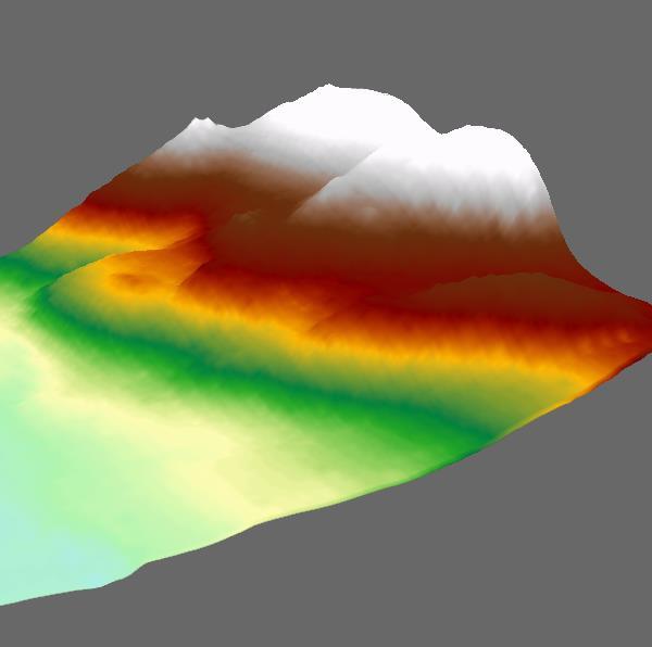
5 Transformations Given a set of points Create a contour map ArcMap s Hot Spot Analysis Filled contours Or a 3-D surface
6 Transformations 0 One of the most important means of transforming data is through spatial interpolation. 0 Can you describe / define interpolation? 0 What does interpolation provide for us (as geospatial scientists)? That is, why do we interpolate data?
 where")

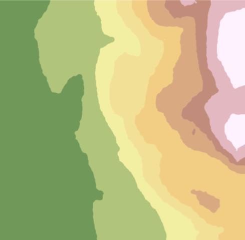
7 Uses of spatial interpolation 0 To create isolines (or other graphics) for visualization 0 To calculate some property of the surface at a location ( ) where measurements weren t taken 0 To change the unit of comparison when using different data structures (e.g., census tracts to planning districts) 0 Both physical and social applications
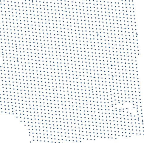
8 Six field representations lattice random points regular grid What are the ways we can represent field data in a GIS? areas TIN contours
9 Basic forms of interpolation 0 Point to points (e.g., random points to a regular grid) 0 Points to lines (e.g., random points to contour lines) 0 Lines to points (e.g., digitized contours to a regular grid) 0 Areas to areas (e.g., census tracts to planning districts) Points Transformations Areas Lines


10 0 Outline: Roadmap 0 What is spatial analysis? 0 Transformations 0 Introduction to spatial interpolation 0 Classification of spatial interpolation methods 0 Interpolation methods 0 Areal interpolation 0 Kriging 0 Summary


11 Considerations 0 Given the wide variety of spatial interpolation methods, you need to consider: 0 Which method best fits the data you have available. 0 Which method best fits the process associated with the data. 0 Which method will produce the result you need. Know your data

12 0 Global versus Local 0 Exact versus Approximate 0 Stochastic versus Deterministic 0 Abrupt versus Smooth Could you describe what each of these dichotomies might encompass? Global Aspatial Local A classification of interpolation methods

13 0 Exact interpolators honour the input data points (which doesn't mean that the surface is 'exact') 0 Approximate interpolators allow for uncertainty in the input data points, which allows for smoothing Exact versus Approximate


14 Stochastic versus Deterministic 0 Stochastic methods incorporate the concept of randomness (similar to a linear regression model a surface of best fit ) 0 Deterministic methods do not use probability theory (they exclude randomness).
15 0 Abrupt interpolators allow for barriers (e.g., faults, fronts) 0 Smooth interpolators produce a smooth surface Abrupt versus Smooth

16 What happens to trends? What about minima / maxima? In previous lectures we ve talked about a few of the problematic issues that might arise, although at the time spatial interpolation wasn t specifically mentioned. How are the parameters selected? How does the data distribution affect the results? Issues to consider


17 Roadmap 0 Outline: 0 What is spatial analysis? 0 Transformations 0 Introduction to spatial interpolation 0 Classification of spatial interpolation methods 0 Interpolation methods 0 Areal interpolation 0 Kriging 0 Summary


18 0 Exact methods of point-based interpolation 0 Proximal: local, exact, abrupt, deterministic 0 best for nominal data (aka Thiessen polygons) Interpolation methods Thiessen polygons are the dual of a Delaunay triangulation


19 0 B-Splines: french curves 0 piecewise polynomials, local, exact, can be smooth, not min/max bound Splines


20 0 Manual interpolation: knowledge-based, local, abrupt, tend to be exact, subjective 0 Often associated with geological mapping Manual methods

21 0 Approximate methods of point-based interpolation 0 Trend surface analysis: similar to regression, global, smooth, deterministic 0 The simplest surface: z = a + bx + cy Interpolation methods


22 0The graph illustrates a quadratic or second-order surface: z = a + bx + cy + dx 2 + exy + fy 2 A simple review of how to use TSA Trend surface analysis


23 0 Fourier Series: assumes that the surface can be approximated by overlaying a series of sine and cosine waves 0 global, smooth, deterministic Fourier methods The first four partial sums of the Fourier series for a square wave
.")
24 0 Moving Average / Distance-Weighted Average: 0 can be exact or, more typically, approximate, local to global, smooth or abrupt 0 the most widely used spatial interpolation method in Geography 0 an almost unlimited number of modifications or variations are available, including: 0 variations on the distance function 0 imposing constraints on the point selection process (e.g., by direction, limiting the number of points, limiting the distance). Distance-weighted methods

25 0 Moving averages are widely used in time series analyses 0 The smoother curves (dark blue on left, red on right) represent the moving average of the original tie series. Note that the smoothed curve can never be higher nor lower than any of the data points. Moving averages
26 point i known value z i location x i weight w i distance d i unknown value location x (z to be interpolated) z (x) wi z i w 1 i i d i i w i Weights decline with distance, β is usually given a value of 2 The estimate is a weighted average Distance-weighted formula

27 IDW: Changing the exponent from 2 to 4 w Effects of changing parameters i 24 1 d i


28 0 Triangulated Irregular Networks (TINs) 0 Not really a form of interpolation, per se, although using TINs one can create contours or regions. 0 Exact, local, abrupt, deterministic. TINs
.")
29 0 Although the process of 'stringing' contours between the vertices of the TIN triangles (or between two grid points) may seem unproblematic, there are some interesting issues (issues which should be addressed in any contouring exercise, but typically are never explicitly addressed). 0 Basically: what assumption should be made with respect to how the surface should be modeled between the known points? Contour placement


30 The default for most programs, although this is likely more realistic. Contour placement


31 0 Outline: Roadmap 0 What is spatial analysis? 0 Transformations 0 Introduction to spatial interpolation 0 Classification of spatial interpolation methods 0 Interpolation methods 0 Areal interpolation 0 Kriging 0 Summary
32 What of areal interpolation? 0 If the areas can be represented by a single point, and the data can be considered to be a field, you can use a pointbased interpolation method (e.g., pop density of CTs). 0 Areal interpolation is actually a complex process. 0 Polygon overlays, and using the proportional areas as weights, is a typical approach (but one that is not reversible nor volume preserving). 0 Pycnophylactic interpolation is a reversible, volume preserving method (see lecture notes for a link to a video that describes this method in detail). (An ArcGIS script.)


33 0 The problem with (nonreversible) polygon overlays: 0 The fundamental assumption is that the field has a homogeneous distribution throughout the zones. Each area is split into 2 equal parts, assuming equal pop in each part. Polygon overlays Note that the totals assigned to the two polygons in the bottom row do not equal the values within each polygon in the top row.
34 Pycnophylactic interpolation


35 0 Outline: Roadmap 0 What is spatial analysis? 0 Transformations 0 Introduction to spatial interpolation 0 Classification of spatial interpolation methods 0 Interpolation methods 0 Areal interpolation 0 Kriging 0 Summary
36 Geostatistical methods: Kriging 0 Kriging 0 stochastic, exact, smooth or abrupt, global or local 0 Natural data are difficult to model using smooth functions because naturally-occurring random fluctuations and measurement error combine to cause irregularities in sampled data values. 0 Kriging was developed to model those stochastic concepts. 0 It is based on the concept of a regionalized variable that has three components:

37 STRUCTURAL This may be represented by the mean or a constant trend. SPATIALLY CORRELATED Data often exhibit positive spatial correlations. data RANDOM NOISE Measurement errors, other errors, random fluctuations. Components of a Regionalized Variable
 The spatially correlated component The random noise component")
38 The structural component (e.g., a linear trend) The spatially correlated component The random noise component (non-fitted) Components of a Regionalized Variable
39 0 Kriging is implemented using a semi-variogram 0 There are many different varieties of kriging, and selecting the appropriate one requires careful consideration of the data. 0 ArcGIS's help file--look up the term kriging provides a lot of information on the various types of kriging that are commonly used in spatial analysis. 0 ArcGIS s tutorial for the Geostatistical Analyst is also very informative (in particular consider the Geostatistical Wizard) Kriging

40 The semivariogram is based on modeling the (squared) differences in the z-values as a function of the distances between the known points. Kriging

41 0 This is an example of a semivariogram produced using ArcGIS's Geostatistical Analyst. Kriging
42 Kriging 0One of the very useful outputs from a kriging analysis is the uncertainty surface that can be generated--we can answer the question: "How good are the predictions?" 0Using some of the data that we used in lab 2 (where you created a TIN), I created an ordinary kriged map and a map showing the standard error of the predictions (and a TIN for comparison).
43 TIN Ordinary kriged prediction map Kriging Prediction standard error map showing data points

44 IDW versus kriging
45 Summary 0 Interpolation is a very important process in GIS, and in particular in spatial analysis. ArcGIS's help files provide a lot of useful information. 0 It is important to know, first, about your data (how was it collected, the spatial distribution of the collection points, the process responsible for creating the 'field' you are mapping), and second, about the spatial interpolation method (its assumptions, faults and fine points). Know your data
Spatial Analysis II. Spatial data analysis Spatial analysis and inference
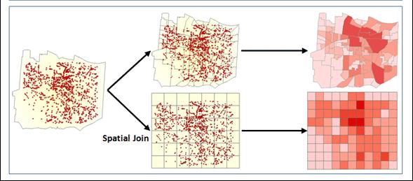
 Spatial Analysis II Spatial data analysis Spatial analysis and inference Roadmap Spatial Analysis I Outline: What is spatial analysis? Spatial Joins Step 1: Analysis of attributes Step 2: Preparing for
Copyright The McGraw-Hill Companies, Inc. Permission required for reproduction or display.
 Chapter 15. SPATIAL INTERPOLATION 15.1 Elements of Spatial Interpolation 15.1.1 Control Points 15.1.2 Type of Spatial Interpolation 15.2 Global Methods 15.2.1 Trend Surface Models Box 15.1 A Worked Example
ENGRG Introduction to GIS
 ENGRG 59910 Introduction to GIS Michael Piasecki October 13, 2017 Lecture 06: Spatial Analysis Outline Today Concepts What is spatial interpolation Why is necessary Sample of interpolation (size and pattern)
Improving Spatial Data Interoperability
 Improving Spatial Data Interoperability A Framework for Geostatistical Support-To To-Support Interpolation Michael F. Goodchild, Phaedon C. Kyriakidis, Philipp Schneider, Matt Rice, Qingfeng Guan, Jordan
Lecture 5 Geostatistics
 Lecture 5 Geostatistics Lecture Outline Spatial Estimation Spatial Interpolation Spatial Prediction Sampling Spatial Interpolation Methods Spatial Prediction Methods Interpolating Raster Surfaces with
Lecture 8. Spatial Estimation
 Lecture 8 Spatial Estimation Lecture Outline Spatial Estimation Spatial Interpolation Spatial Prediction Sampling Spatial Interpolation Methods Spatial Prediction Methods Interpolating Raster Surfaces
Spatial analysis. Spatial descriptive analysis. Spatial inferential analysis:
 Spatial analysis Spatial descriptive analysis Point pattern analysis (minimum bounding box, mean center, weighted mean center, standard distance, nearest neighbor analysis) Spatial clustering analysis
11. Kriging. ACE 492 SA - Spatial Analysis Fall 2003
 11. Kriging ACE 492 SA - Spatial Analysis Fall 2003 c 2003 by Luc Anselin, All Rights Reserved 1 Objectives The goal of this lab is to further familiarize yourself with ESRI s Geostatistical Analyst, extending
2.6 Two-dimensional continuous interpolation 3: Kriging - introduction to geostatistics. References - geostatistics. References geostatistics (cntd.
 .6 Two-dimensional continuous interpolation 3: Kriging - introduction to geostatistics Spline interpolation was originally developed or image processing. In GIS, it is mainly used in visualization o spatial
GIST 4302/5302: Spatial Analysis and Modeling
 GIST 4302/5302: Spatial Analysis and Modeling Review Guofeng Cao www.gis.ttu.edu/starlab Department of Geosciences Texas Tech University guofeng.cao@ttu.edu Spring 2016 Course Outlines Spatial Point Pattern
Report on Kriging in Interpolation
 Tabor Reedy ENVS421 3/12/15 Report on Kriging in Interpolation In this project I explored use of the geostatistical analyst extension and toolbar in the process of creating an interpolated surface through
Umeå University Sara Sjöstedt-de Luna Time series analysis and spatial statistics
 Umeå University 01-05-5 Sara Sjöstedt-de Luna Time series analysis and spatial statistics Laboration in ArcGIS Geostatistical Analyst These exercises are aiming at helping you understand ArcGIS Geostatistical
Software. People. Data. Network. What is GIS? Procedures. Hardware. Chapter 1
 People Software Data Network Procedures Hardware What is GIS? Chapter 1 Why use GIS? Mapping Measuring Monitoring Modeling Managing Five Ms of Applied GIS Chapter 2 Geography matters Quantitative analyses
Geog 469 GIS Workshop. Data Analysis
 Geog 469 GIS Workshop Data Analysis Outline 1. What kinds of need-to-know questions can be addressed using GIS data analysis? 2. What is a typology of GIS operations? 3. What kinds of operations are useful
Spatial Analyst. By Sumita Rai
 ArcGIS Extentions Spatial Analyst By Sumita Rai Overview What does GIS do? How does GIS work data models Extension to GIS Spatial Analyst Spatial Analyst Tasks & Tools Surface Analysis Surface Creation
Concepts and Applications of Kriging. Eric Krause
 Concepts and Applications of Kriging Eric Krause Sessions of note Tuesday ArcGIS Geostatistical Analyst - An Introduction 8:30-9:45 Room 14 A Concepts and Applications of Kriging 10:15-11:30 Room 15 A
Gravity and Magnetic Anomalies Compared to Moho Depth throughout the State of Texas
 Gravity and Magnetic Anomalies Compared to Moho Depth throughout the State of Texas Taylor Borgfeldt Introduction My Master s thesis is to improve and create additional crustal seismic velocity models
COMPARISON OF DIGITAL ELEVATION MODELLING METHODS FOR URBAN ENVIRONMENT
 COMPARISON OF DIGITAL ELEVATION MODELLING METHODS FOR URBAN ENVIRONMENT Cahyono Susetyo Department of Urban and Regional Planning, Institut Teknologi Sepuluh Nopember, Indonesia Gedung PWK, Kampus ITS,
Spatial Data Analysis in Archaeology Anthropology 589b. Kriging Artifact Density Surfaces in ArcGIS
 Spatial Data Analysis in Archaeology Anthropology 589b Fraser D. Neiman University of Virginia 2.19.07 Spring 2007 Kriging Artifact Density Surfaces in ArcGIS 1. The ingredients. -A data file -- in.dbf
Concepts and Applications of Kriging. Eric Krause Konstantin Krivoruchko
 Concepts and Applications of Kriging Eric Krause Konstantin Krivoruchko Outline Introduction to interpolation Exploratory spatial data analysis (ESDA) Using the Geostatistical Wizard Validating interpolation
Geog183: Cartographic Design and Geovisualization Spring Quarter 2018 Lecture 11: Dasymetric and isarithmic mapping
 Geog183: Cartographic Design and Geovisualization Spring Quarter 2018 Lecture 11: Dasymetric and isarithmic mapping Discrete vs. continuous revisited Choropleth suited to discrete areal, but suffers from
Introduction to GIS - 2
 Introduction to GIS - 2 Outline Using GIS Representation of spatial objects in GIS Prof. D. Nagesh Kumar Department of Civil Engineering Indian Institute of Science Bangalore 560 012, India http://www.civil.iisc.ernet.in/~nagesh
Michael Harrigan Office hours: Fridays 2:00-4:00pm Holden Hall
 Announcement New Teaching Assistant Michael Harrigan Office hours: Fridays 2:00-4:00pm Holden Hall 209 Email: michael.harrigan@ttu.edu Guofeng Cao, Texas Tech GIST4302/5302, Lecture 2: Review of Map Projection
Concepts and Applications of Kriging
 2013 Esri International User Conference July 8 12, 2013 San Diego, California Technical Workshop Concepts and Applications of Kriging Eric Krause Konstantin Krivoruchko Outline Intro to interpolation Exploratory
Comparison of rainfall distribution method
 Team 6 Comparison of rainfall distribution method In this section different methods of rainfall distribution are compared. METEO-France is the French meteorological agency, a public administrative institution
ArcGIS Pro: Analysis and Geoprocessing. Nicholas M. Giner Esri Christopher Gabris Blue Raster
 ArcGIS Pro: Analysis and Geoprocessing Nicholas M. Giner Esri Christopher Gabris Blue Raster Agenda What is Analysis and Geoprocessing? Analysis in ArcGIS Pro - 2D (Spatial xy) - 3D (Elevation - z) - 4D
ArcGIS for Geostatistical Analyst: An Introduction. Steve Lynch and Eric Krause Redlands, CA.
 ArcGIS for Geostatistical Analyst: An Introduction Steve Lynch and Eric Krause Redlands, CA. Outline - What is geostatistics? - What is Geostatistical Analyst? - Spatial autocorrelation - Geostatistical
POPULAR CARTOGRAPHIC AREAL INTERPOLATION METHODS VIEWED FROM A GEOSTATISTICAL PERSPECTIVE
 CO-282 POPULAR CARTOGRAPHIC AREAL INTERPOLATION METHODS VIEWED FROM A GEOSTATISTICAL PERSPECTIVE KYRIAKIDIS P. University of California Santa Barbara, MYTILENE, GREECE ABSTRACT Cartographic areal interpolation
Make it Spatial. Josh Tanner. Theresa Burcsu. Tools, techniques, and tips for incorporating GIS into your research
 Make it Spatial Tools, techniques, and tips for incorporating GIS into your research Theresa Burcsu Josh Tanner Oregon GIS Framework Coordinator GIS Analyst & Web Administrator Geospatial Enterprise Office
Spatial Analysis I. Spatial data analysis Spatial analysis and inference
 Spatial Analysis I Spatial data analysis Spatial analysis and inference Roadmap Outline: What is spatial analysis? Spatial Joins Step 1: Analysis of attributes Step 2: Preparing for analyses: working with
Concepts and Applications of Kriging
 Esri International User Conference San Diego, California Technical Workshops July 24, 2012 Concepts and Applications of Kriging Konstantin Krivoruchko Eric Krause Outline Intro to interpolation Exploratory
Luc Anselin Spatial Analysis Laboratory Dept. Agricultural and Consumer Economics University of Illinois, Urbana-Champaign
 GIS and Spatial Analysis Luc Anselin Spatial Analysis Laboratory Dept. Agricultural and Consumer Economics University of Illinois, Urbana-Champaign http://sal.agecon.uiuc.edu Outline GIS and Spatial Analysis
Kriging Luc Anselin, All Rights Reserved
 Kriging Luc Anselin Spatial Analysis Laboratory Dept. Agricultural and Consumer Economics University of Illinois, Urbana-Champaign http://sal.agecon.uiuc.edu Outline Principles Kriging Models Spatial Interpolation
Spatial Analysis and Modeling (GIST 4302/5302) Guofeng Cao Department of Geosciences Texas Tech University
 Guofeng Cao Department of Geosciences Texas Tech University") Spatial Analysis and Modeling (GIST 4302/5302) Guofeng Cao Department of Geosciences Texas Tech University TTU Graduate Certificate Geographic Information Science and Technology (GIST) 3 Core Courses and
Spatial Analysis and Modeling (GIST 4302/5302) Guofeng Cao Department of Geosciences Texas Tech University TTU Graduate Certificate Geographic Information Science and Technology (GIST) 3 Core Courses and
GIST 4302/5302: Spatial Analysis and Modeling
 GIST 4302/5302: Spatial Analysis and Modeling Lecture 2: Review of Map Projections and Intro to Spatial Analysis Guofeng Cao http://thestarlab.github.io Department of Geosciences Texas Tech University
Interpolating Raster Surfaces
 Interpolating Raster Surfaces You can use interpolation to model the surface of a feature or a phenomenon all you need are sample points, an interpolation method, and an understanding of the feature or
Geostatistics: Kriging
 Geostatistics: Kriging 8.10.2015 Konetekniikka 1, Otakaari 4, 150 10-12 Rangsima Sunila, D.Sc. Background What is Geostatitics Concepts Variogram: experimental, theoretical Anisotropy, Isotropy Lag, Sill,
Creating Faulted Geologic Surfaces with ArcGIS
 What You Will Need ArcGIS 10.2 for Desktop (Basic, Standard, or Advanced license level) ArcGIS Geostatistical Analyst extension ArcGIS Spatial Analyst extension Sample dataset downloaded from esri.com/arcuser
Propagation of Errors in Spatial Analysis
 Stephen F. Austin State University SFA ScholarWorks Faculty Presentations Spatial Science 2001 Propagation of Errors in Spatial Analysis Peter P. Siska I-Kuai Hung Arthur Temple College of Forestry and
Class 9. Query, Measurement & Transformation; Spatial Buffers; Descriptive Summary, Design & Inference
 Class 9 Query, Measurement & Transformation; Spatial Buffers; Descriptive Summary, Design & Inference Spatial Analysis Turns raw data into useful information by adding greater informative content and value
GIST 4302/5302: Spatial Analysis and Modeling Lecture 2: Review of Map Projections and Intro to Spatial Analysis
 GIST 4302/5302: Spatial Analysis and Modeling Lecture 2: Review of Map Projections and Intro to Spatial Analysis Guofeng Cao http://www.spatial.ttu.edu Department of Geosciences Texas Tech University guofeng.cao@ttu.edu
Geog 210C Spring 2011 Lab 6. Geostatistics in ArcMap
 Geog 210C Spring 2011 Lab 6. Geostatistics in ArcMap Overview In this lab you will think critically about the functionality of spatial interpolation, improve your kriging skills, and learn how to use several
A Geostatistical Approach to Linking Geographically-Aggregated Data From Different Sources
 A Geostatistical Approach to Linking Geographically-Aggregated Data From Different Sources Carol A. Gotway Crawford National Center for Environmental Health Centers for Disease Control and Prevention,
COURSE SCHEDULE, GRADING, and READINGS
 COURSE SCHEDULE, GRADING, and READINGS Note: All academic classes will be held in the GIS lab at Royal Thimphu College. These dates are listed here. Other days will involve travel or days off, and the
An Information Model for Maps: Towards Cartographic Production from GIS Databases
 An Information Model for s: Towards Cartographic Production from GIS Databases Aileen Buckley, Ph.D. and Charlie Frye Senior Cartographic Researchers, ESRI Barbara Buttenfield, Ph.D. Professor, University
ENGRG Introduction to GIS
 ENGRG 59910 Introduction to GIS Michael Piasecki March 17, 2014 Lecture 08: Terrain Analysis Outline: Terrain Analysis Earth Surface Representation Contour TIN Mass Points Digital Elevation Models Slope
Integration of Topographic and Bathymetric Digital Elevation Model using ArcGIS. Interpolation Methods: A Case Study of the Klamath River Estuary
 Integration of Topographic and Bathymetric Digital Elevation Model using ArcGIS Interpolation Methods: A Case Study of the Klamath River Estuary by Rachel R. Rodriguez A Thesis Presented to the FACULTY
Geometric Algorithms in GIS
 Geometric Algorithms in GIS GIS Software Dr. M. Gavrilova GIS System What is a GIS system? A system containing spatially referenced data that can be analyzed and converted to new information for a specific
Overview key concepts and terms (based on the textbook Chang 2006 and the practical manual)
") Introduction Geo-information Science (GRS-10306) Overview key concepts and terms (based on the textbook 2006 and the practical manual) Introduction Chapter 1 Geographic information system (GIS) Geographically
Introduction Geo-information Science (GRS-10306) Overview key concepts and terms (based on the textbook 2006 and the practical manual) Introduction Chapter 1 Geographic information system (GIS) Geographically
Spatial Analysis with ArcGIS Pro STUDENT EDITION
 Spatial Analysis with ArcGIS Pro STUDENT EDITION Copyright 2018 Esri All rights reserved. Course version 2.0. Version release date November 2018. Printed in the United States of America. The information
Types of spatial data. The Nature of Geographic Data. Types of spatial data. Spatial Autocorrelation. Continuous spatial data: geostatistics
 The Nature of Geographic Data Types of spatial data Continuous spatial data: geostatistics Samples may be taken at intervals, but the spatial process is continuous e.g. soil quality Discrete data Irregular:
UNDERSTANDING ENGINEERING MATHEMATICS
 UNDERSTANDING ENGINEERING MATHEMATICS JOHN BIRD WORKED SOLUTIONS TO EXERCISES 1 INTRODUCTION In Understanding Engineering Mathematic there are over 750 further problems arranged regularly throughout the
ENGRG Introduction to GIS
 ENGRG 59910 Introduction to GIS Michael Piasecki November 17, 2017 Lecture 11: Terrain Analysis Outline: Terrain Analysis Earth Surface Representation Contour TIN Mass Points Digital Elevation Models Slope
Introduction To Raster Based GIS Dr. Zhang GISC 1421 Fall 2016, 10/19
 Introduction To Raster Based GIS Dr. Zhang GISC 1421 Fall 2016, 10/19 Model of the course Using and making maps Navigating GIS maps Map design Working with spatial data Geoprocessing Spatial data infrastructure
Aileen Buckley, Ph.D. and Charlie Frye
 An Information Model for Maps: Towards Production from GIS Databases Aileen Buckley, Ph.D. and Charlie Frye Researchers, ESRI GIS vs. cart GIS Outline of the presentation Introduction Differences between
GEOGRAPHY 350/550 Final Exam Fall 2005 NAME:
 1) A GIS data model using an array of cells to store spatial data is termed: a) Topology b) Vector c) Object d) Raster 2) Metadata a) Usually includes map projection, scale, data types and origin, resolution
Creation and modification of a geological model Program: Stratigraphy
 Engineering manual No. 39 Updated: 11/2018 Creation and modification of a geological model Program: Stratigraphy File: Demo_manual_39.gsg Introduction The aim of this engineering manual is to explain the
Interpolation Techniques
 Interpolation Techniques Using QGIS Tutorial ID: IGET_SA_002 This tutorial has been developed by BVIEER as part of the IGET web portal intended to provide easy access to geospatial education. This tutorial
Uncertainty modeling of glacier surface mapping from GPS: An example from Pedersenbreen, Arctic
 Uncertainty modeling of glacier surface mapping from GPS: An example from Pedersenbreen, Arctic Xi Zhao, Songtao Ai 1 Chinese Antarctic Center of Surveying and Mapping, Wuhan University, Wuhan 430079,
8.9 Geographical Information Systems Advantages of GIS
 8.9 Geographical Information Systems A Geographic Information System (GIS) is a computer-based system that is used in input, storage, analysis manipulation, retrieval, and output, of spatial data. These
Introduction to GIS I
 Introduction to GIS Introduction How to answer geographical questions such as follows: What is the population of a particular city? What are the characteristics of the soils in a particular land parcel?
GIS APPLICATIONS IN SOIL SURVEY UPDATES
 GIS APPLICATIONS IN SOIL SURVEY UPDATES ABSTRACT Recent computer hardware and GIS software developments provide new methods that can be used to update existing digital soil surveys. Multi-perspective visualization
Introduction to Geographic
 Eighth Edition Introduction to Geographic Information Systems Kang-tsung Chang University of Idaho Mc Graw Hill Education Preface xiv CHAPTER 1 Introduction 1 1.1 GIS 2 1.1.1 Components of a GIS 3 1.1.2
Working with Digital Elevation Models and Digital Terrain Models in ArcMap 9
 Working with Digital Elevation Models and Digital Terrain Models in ArcMap 9 1 TABLE OF CONTENTS INTRODUCTION...3 WORKING WITH DIGITAL TERRAIN MODEL (DTM) DATA FROM NRVIS, CITY OF KITCHENER, AND CITY OF
Nature of Spatial Data. Outline. Spatial Is Special
 Nature of Spatial Data Outline Spatial is special Bad news: the pitfalls of spatial data Good news: the potentials of spatial data Spatial Is Special Are spatial data special? Why spatial data require
Introduction to the 176A labs and ArcGIS
 Introduction to the 176A labs and ArcGIS Acknowledgement: Slides by David Maidment, U Texas-Austin and Francisco Olivera (TAMU) Purpose of the labs Hands-on experience with one software pakage Introduction
Working with Digital Elevation Models and Spot Heights in ArcMap
 Working with Digital Elevation Models and Spot Heights in ArcMap 10.3.1 1 TABLE OF CONTENTS INTRODUCTION... 3 WORKING WITH SPOT HEIGHTS FROM NRVIS, CITY OF KITCHENER, AND CITY OF TORONTO...4 WORKING WITH
Outline. Introduction to SpaceStat and ESTDA. ESTDA & SpaceStat. Learning Objectives. Space-Time Intelligence System. Space-Time Intelligence System
 Outline I Data Preparation Introduction to SpaceStat and ESTDA II Introduction to ESTDA and SpaceStat III Introduction to time-dynamic regression ESTDA ESTDA & SpaceStat Learning Objectives Activities
Ihab Hijazi. Isam Jerdaneh University. Planning Engineering. department nablus, Palestine.
 Generating a geotechnical map for the city of nablus by comparing two functions of GIS software Lama Asmah Ihab Hijazi Isam Jerdaneh An-najah national Urban and regional Civil Engineering University Planning
ADVANCE GIS ANALYSIS ON ZONAL URBAN PLAN PROJECT
 Journal of Young Scientist, Volume II, 2014 ISSN 2344-1283; ISSN CD-ROM 2344-1291; ISSN Online 2344-1305; ISSN-L 2344 1283 ADVANCE GIS ANALYSIS ON ZONAL URBAN PLAN PROJECT Andrei-Șerban TOMPEA 1 Scientific
FOURIER TRANSFORMS. At, is sometimes taken as 0.5 or it may not have any specific value. Shifting at
 Chapter 2 FOURIER TRANSFORMS 2.1 Introduction The Fourier series expresses any periodic function into a sum of sinusoids. The Fourier transform is the extension of this idea to non-periodic functions by
Introduction to Geographic Information Systems (GIS): Environmental Science Focus
: Environmental Science Focus") Introduction to Geographic Information Systems (GIS): Environmental Science Focus September 9, 2013 We will begin at 9:10 AM. Login info: Username:!cnrguest Password: gocal_bears Instructor: Domain: CAMPUS
Introduction to Geographic Information Systems (GIS): Environmental Science Focus September 9, 2013 We will begin at 9:10 AM. Login info: Username:!cnrguest Password: gocal_bears Instructor: Domain: CAMPUS
Creation and modification of a geological model Program: Stratigraphy
 Engineering manual No. 39 Updated: 02/2018 Creation and modification of a geological model Program: Stratigraphy File: Demo_manual_39.gsg Introduction The aim of this engineering manual is to explain the
Water Volume Calculation of Hill Country Trinity Aquifer Blanco, Hays, and Travis Counties, Central Texas
 Water Volume Calculation of Hill Country Trinity Aquifer Blanco, Hays, and Travis Counties, Central Texas GIS and GPS Applications in Earth Science Saya Ahmed December, 2010 1 Introduction: Trinity Aquifer
Popular Mechanics, 1954
 Introduction to GIS Popular Mechanics, 1954 1986 $2,599 1 MB of RAM 2017, $750, 128 GB memory, 2 GB of RAM Computing power has increased exponentially over the past 30 years, Allowing the existence of
Intro to GIS In Review
 Intro to GIS In Review GIS Analysis Winter 2016 GIS A quarter in review Geographic data types Acquiring GIS data Projections / Coordinate systems Working with attribute tables Data classification Map design
Basic Geostatistics: Pattern Description
 Basic Geostatistics: Pattern Description A SpaceStat Software Tutorial Copyright 2013, BioMedware, Inc. (www.biomedware.com). All rights reserved. SpaceStat and BioMedware are trademarks of BioMedware,
Impacts of precipitation interpolation on hydrologic modeling in data scarce regions
 Impacts of precipitation interpolation on hydrologic modeling in data scarce regions 1, Shamita Kumar, Florian Wilken 1, Peter Fiener 1 and Karl Schneider 1 1 Hydrogeography and Climatology Research Group,
A Comparative Analysis of Extracted Heights from Topographic Maps and measured Reduced Levels in Kumasi, Ghana.
 A Comparative Analysis of Extracted Heights from Topographic Maps and measured Reduced Levels in Kumasi, Ghana. J. Ayer 1*, A.B. Agyemang 1, F. Yeboah 2, E. M. Osei Jnr. 1, S. Abebrese 1, I. Suleman 1
Geographic Information Systems (GIS) in Environmental Studies ENVS Winter 2003 Session III
 in Environmental Studies ENVS Winter 2003 Session III") Geographic Information Systems (GIS) in Environmental Studies ENVS 6189 3.0 Winter 2003 Session III John Sorrell York University sorrell@yorku.ca Session Purpose: To discuss the various concepts of space,
Geographic Information Systems (GIS) in Environmental Studies ENVS 6189 3.0 Winter 2003 Session III John Sorrell York University sorrell@yorku.ca Session Purpose: To discuss the various concepts of space,
Outline. Chapter 1. A history of products. What is ArcGIS? What is GIS? Some GIS applications Introducing the ArcGIS products How does GIS work?
 Outline Chapter 1 Introducing ArcGIS What is GIS? Some GIS applications Introducing the ArcGIS products How does GIS work? Basic data formats The ArcCatalog interface 1-1 1-2 A history of products Arc/Info
Extent of Radiological Contamination in Soil at Four Sites near the Fukushima Daiichi Power Plant, Japan (ArcGIS)
") Extent of Radiological Contamination in Soil at Four Sites near the Fukushima Daiichi Power Plant, Japan (ArcGIS) Contact: Ted Parks, AMEC Foster Wheeler, theodore.parks@amecfw.com, Alex Mikszewski, AMEC
Extent of Radiological Contamination in Soil at Four Sites near the Fukushima Daiichi Power Plant, Japan (ArcGIS) Contact: Ted Parks, AMEC Foster Wheeler, theodore.parks@amecfw.com, Alex Mikszewski, AMEC
Spatial Analysis 1. Introduction
 Spatial Analysis 1 Introduction Geo-referenced Data (not any data) x, y coordinates (e.g., lat., long.) ------------------------------------------------------ - Table of Data: Obs. # x y Variables -------------------------------------
Overview of Statistical Analysis of Spatial Data
 Overview of Statistical Analysis of Spatial Data Geog 2C Introduction to Spatial Data Analysis Phaedon C. Kyriakidis www.geog.ucsb.edu/ phaedon Department of Geography University of California Santa Barbara
[Figure 1 about here]
![[Figure 1 about here]](/thumbs/87/95828660.jpg "[Figure 1 about here]") TITLE: FIELD-BASED SPATIAL MODELING BYLINE: Michael F. Goodchild, University of California, Santa Barbara, www.geog.ucsb.edu/~good SYNONYMS: None DEFINITION: A field (or continuous field) is defined as
TITLE: FIELD-BASED SPATIAL MODELING BYLINE: Michael F. Goodchild, University of California, Santa Barbara, www.geog.ucsb.edu/~good SYNONYMS: None DEFINITION: A field (or continuous field) is defined as
Optimizing Sampling Schemes for Mapping and Dredging Polluted Sediment Layers
 This file was created by scanning the printed publication. Errors identified by the software have been corrected; however, some errors may remain. Optimizing Sampling Schemes for Mapping and Dredging Polluted
Exercise 6: Using Burn Severity Data to Model Erosion Risk
 Exercise 6: Using Burn Severity Data to Model Erosion Risk Document Updated: November 2009 Software Versions: ERDAS Imagine 9.3 and ArcGIS 9.3, Microsoft Office 2007 Introduction A common use of burn severity
Outline. Geographic Information Analysis & Spatial Data. Spatial Analysis is a Key Term. Lecture #1
 Geographic Information Analysis & Spatial Data Lecture #1 Outline Introduction Spatial Data Types: Objects vs. Fields Scale of Attribute Measures GIS and Spatial Analysis Spatial Analysis is a Key Term
GED 554 IT & GIS. Lecture 6 Exercise 5. May 10, 2013
 GED 554 IT & GIS Lecture 6 Exercise 5 May 10, 2013 Free GIS data sources ******************* Mapping numerical data & Symbolization ******************* Exercise: Making maps for presentation GIS DATA SOFTWARE
Gridding of precipitation and air temperature observations in Belgium. Michel Journée Royal Meteorological Institute of Belgium (RMI)
") Gridding of precipitation and air temperature observations in Belgium Michel Journée Royal Meteorological Institute of Belgium (RMI) Gridding of meteorological data A variety of hydrologic, ecological,
Gridding of precipitation and air temperature observations in Belgium Michel Journée Royal Meteorological Institute of Belgium (RMI) Gridding of meteorological data A variety of hydrologic, ecological,
Types of Spatial Data
 Spatial Data Types of Spatial Data Point pattern Point referenced geostatistical Block referenced Raster / lattice / grid Vector / polygon Point Pattern Data Interested in the location of points, not their
A Spatial Analysis of House Prices in the Kingdom of Fife, Scotland
 125 A Spatial Analysis of House Prices in the Kingdom of Fife, Scotland Julia ZMÖLNIG 1, Melanie N. TOMINTZ 1 and Stewart A. FOTHERINGHAM 2 1 Carinthia University of Applied Sciences, Villach / Austria
Trouble-Shooting Coordinate System Problems
 Trouble-Shooting Coordinate System Problems Written by Barbara M. Parmenter, revised 2/25/2014 OVERVIEW OF THE EXERCISE... 1 COPYING THE MAP PROJECTION EXERCISE FOLDER TO YOUR H: DRIVE OR DESKTOP... 2
Lectures 9-10: Polynomial and piecewise polynomial interpolation
 Lectures 9-1: Polynomial and piecewise polynomial interpolation Let f be a function, which is only known at the nodes x 1, x,, x n, ie, all we know about the function f are its values y j = f(x j ), j
Dasymetric Mapping for Disaggregating Coarse Resolution Population Data
 Dasymetric Mapping for Disaggregating Coarse Resolution Population Data Jeremy Mennis and Torrin Hultgren Department of Geography and Urban Studies, Temple University Department of Geography, University
Determining a Useful Interpolation Method for Surficial Sediments in the Gulf of Maine Ian Cochran
 Determining a Useful Interpolation Method for Surficial Sediments in the Gulf of Maine Ian Cochran ABSTRACT This study was conducted to determine if an interpolation of surficial sediments in the Gulf
GIS and Forest Engineering Applications FE 357 Lecture: 2 hours Lab: 2 hours 3 credits
 GIS and Forest Engineering Applications FE 357 Lecture: 2 hours Lab: 2 hours 3 credits Instructor: Michael Wing Assistant Professor Forest Engineering Department Oregon State University Peavy Hall 275
Introduction to the 176A labs and ArcGIS Purpose of the labs
 Introduction to the 176A labs and ArcGIS Purpose of the labs Acknowledgement: Slides by David Maidment, U Texas-Austin and Francisco Olivera (TAMU) Hands-on experience with a leading software package Introduction
ArcGIS Geostatistical Analyst: Powerful Exploration and Data Interpolation Solutions
 TM ArcGIS Geostatistical Analyst: Powerful Exploration and Data Interpolation Solutions An ESRI White Paper March 2001 ESRI 380 New York St., Redlands, CA 92373-8100, USA TEL 909-793-2853 FAX 909-793-5953
Tutorial 8 Raster Data Analysis
 Objectives Tutorial 8 Raster Data Analysis This tutorial is designed to introduce you to a basic set of raster-based analyses including: 1. Displaying Digital Elevation Model (DEM) 2. Slope calculations