Land Restoration /Reclamation Monitoring of Opencast Coal Mines of WCL Based On Satellite Data for the Year 2009 CMPDI. A Miniratna Company
|
|
|
- Shavonne Hensley
- 6 years ago
- Views:
Transcription

1 Land Restoration /Reclamation Monitoring of Opencast Coal Mines of WCL Based On Satellite Data for the Year 2009 CMPDI A Miniratna Company
2 Land Restoration /Reclamation Monitoring of Opencast Coal Mines of WCL Based On Satellite Data for the Year March-2010 Remote Sensing Cell Geomatics Division CMPDI, Ranchi
3 CONTENTS Executive Summary ii-iv 1.0 Background Objective Methodology Work plan Land Reclamation in WCL 6 i
4 Executive Summary 1.0 Project Land restoration / reclamation monitoring of 10 opencast coal mines of Western Coalfields Ltd. (WCL) producing 5 million cu.m. and more (Coal+OB) per year based on satellite data, regularly on annual basis. 2.0 Objective Objective of the land restoration / reclamation monitoring is to assess the area of backfilled, plantation, social forestry, active mining area, water bodies, and distribution of wasteland, agricultural land and forest in the leasehold area of the project. This will help in assessing the progressive status of mined land reclamation and to take up remedial measures, if any, required for environmental protection. 3.0 Salient Findings Out of the total mine leasehold area of Km 2 of the 10 projects of WCL, Viz. Sasti, Padmapur, Durgapur, Mugoli, Umrer, Ukni, Niljai, New Majri, Pimpalgaon and Ghugus considered for monitoring during ; total mined out area is only Km2 (54.53%) of which Km2 area (46.14%) has been planted, Km 2 area (40.14%) has been backfilled and 6.76 Km 2 area (13.72%) is under active mining. It is evident from the analysis that 86.28% areas of the OC projects has already been reclaimed. Project wise details are given in Table-1 & Fig -1. On comparing the status of land reclamation for the year 2009 with respect to the year 2008 in different OC projects, analysis reveals that area of land reclamation has increased from Km 2 (Yr. 2008) to Km 2 (Yr. 2009). Out of 10 projects of WCL, New Majri OC (93.58%) ranks on top for land reclamation followed by Sasti OC(92.89%) and Ghugus OC (91.54%). Area of plantation has increased from 17.18Km 2 (Yr.2008) to 22.73Km 2 (Yr.2009) in WCL. This increase of 5.55 Km 2 in area of plantation in one year is the result of the efforts of the WCL taken up towards environmental protection. ii
5 Table-1 Projectwise Land Reclaimation Status in OC projects of Western Coalfileds Ltd Based on Satellite data of the Year 2008 and 2009 Area in Sq Km (% Calculated in respect of total mined out area ) Sl No. 1 2 Projects Sasti Padmapur Leasehold Plantation Backfilled Active Mining Area Total Mined out Area Total Reclaimed Area i i ii iii iv ii+iii+iv ii+iii % % Durgapur % Mugoli Umrer Ukni Neeljai New Majri Pimpalgaon % % % % % % Ghugus Total % % iii
6 Figure : 1 Project wise Land Reclamation status in the year Area (Sq km) Sasti Padmapur Durgapur Mugoli Umrer Ukni Neeljai New Majri Pimpalgaon Ghugus Leasehold Area Mined out Area Reclaimed Area Fig. 1 : Land Reclamation Status in OC projects of WCL iv
7 1.0 Background 1.1 All human activities are based on the land which is most scarce natural resource in our country. Per capita land availability in India is the lowest owing to high population density and less land mass. Out of total 329 million hectare (mha) land mass of the country, coal mining is limited to only on 0.10% (0.36mha) area. As per XI Plan, to meet the energy demand of the country, coal production would be raised to 680 million tonnes by the end of the year for which about 40,000 hectare of land would have to be acquired for coal mining projects. It has been envisaged that 85% coal production would be from opencast mines, which causes land degradation due to ground breaking. There is an urgent need to reclaim and restore the mined out land for its productive use for sustainable development of the coal mining. This will not only mitigate environmental degradation, but would also enable coal companies to offer the restored lands to displaced families which would help in creating a more congenial environment for land acquisition in future. 1.2 Keeping above in view, Coal India Ltd. requested Central Mine Planning & Design Institute (CMPDI), Ranchi who has well a equipped remote sensing facilities and capabilities to develop an effective system of surveillance for land reclamation/ restoration for all the opencast coal mines with production of more than 5 million cu. m. per annum (coal + OB taken together) based on remote sensing satellite data, regularly on annual basis for sustainable development of mining operation within command area of CIL and its subsidiaries. The annual land reclamation/restoration status report of all such mines to be put on the website of CIL, ( CMPDI ( and the concerned coal companies in public domain. Detail report to be submitted to State Pollution Control Board and MoEF and concerned CIL s subsidiaries. Such monitoring would not only facilitate in taking timely mitigation measures against environmental degradation, but would also enable coal companies to utilize the reclaimed land for larger socio-economic benefits in a planned way. 1
8 1.3 CMPDI undertook the above assignment, and the present report is embodying the finding of the study carried out during for the WCL projects. 2.0 Objective Objective of the land reclamation/restoration monitoring is to assess the area of backfilled, plantation, OB dumps, social forestry, active mining area, settlements and water bodies, distribution of wasteland, agricultural land and forest land in the leasehold area of the project. This is an important step taken up for assessing the progressive status of mined land reclamation and for taking up remedial measures, if any, required for environmental protection. 3.0 Methodology There are number of steps involved between raw satellite data procurement and preparation of final map. National Remote Sensing Centre (NRSC) Hyderabad, being the nodal agency for satellite data supply in India, provides only raw digital satellite data, which needs further digital image processing for extracting the information and map preparation before uploading the same in the website. Methodology for land reclamation monitoring is given in given in fig 2. Following steps are involved in land reclamation /restoration monitoring: 2
9 Basic Data IRS P6 (LISS - IV) Data Source Pre-processing, geometric correction, rectification & geo - refrencing Secondary Data Topographical Maps (Scale 1:50,000) Image Enhancement Training set Identification Geocoded FCC Generation Creation of Vector Database (Drainage, Road, Railway network, Block boundary, Forest Boundary etc.) Signature Generation Training Set Refinement Report Preparation Pre-Field Classification Validation through Ground Truthing Pass Fail Integration of Raster & Vector database in GIS Final land Reclamation map Methodology for Land Reclamation Monitoring Fig.2 Methodology for land reclamation monitoring 3.1 Data Procurement: After browsing the data quality and date of pass on internet, supply order for data is placed to NRSC. Secondary data like leasehold boundary, topo sheets are procured for creation of vector database. 3.2 Satellite Data Processing: Satellite data are processed using ERDAS IMAGINE digital image processing s/w. Methodology involves the following major steps: Rectification & Georeferencing: Inaccuracies in digital imagery may occur due to systematic errors attributed to earth curvature and rotation as well as nonsystematic errors attributed to satellite receiving station itself. Raw digital images contain geometric distortions, which make them unusable as maps. Therefore, georeferencing is required for correction of image data using ground control points (GCP) to make it compatible to SoI toposheet. 3
10 Image enhancement: To improve the interpretability of the raw data, image enhancement is necessary. local operations modify the value of each pixel based on brightness value of neighbouring pixels using ERDAS IMAGINE 9.3 s/w. and enhance the image quality for interpretation. Training set selection Training set requires to be selected, so that software can classify the image data accurately. The image data are analysed based on the interpretation keys. These keys are evolved from certain fundamental image-elements such as tone/colour, size, shape, texture, pattern, location, association and shadow. Based on the image-elements and other geo-technical elements like land form, drainage pattern and physiography; training sets were selected/identified for each land use/cover class. Field survey was carried out by taking selective traverses in order to collect the ground information (or reference data) so that training sets are selected accurately in the image. This was intended to serve as an aid for classification. Classification and Accuracy assessment Image classification is carried out using the maximum likelihood algorithm. The classification proceeds through the following steps: (a) calculation of statistics [i.e. signature generation] for the identified training areas, and (b) the decision boundary of maximum probability based on the mean vector, variance, covariance and correlation matrix of the pixels. After evaluating the statistical parameters of the training sets, reliability test of training sets is conducted by measuring the statistical separation between the classes that resulted from computing divergence matrix. The overall accuracy of the classification was finally assessed with reference to ground truth data. Area calculation The area of each land use class in the leasehold is determined using ERDAS IMAGINE v. 9.3 s/w. 4
11 Overlay of Vector data base Vector data base created based on secondary data. Vector layer like drainage, railway line, leasehold boundary, forest boundary etc. are superimposed on the image as vector layer in the Arc GIS database. Pre-field map preparation Pre-field map is prepared for validation of the classification result 3.3 Ground Truthing: Selective ground verification of the land use classes are carried out in the field and necessary corrections if required, are incorporated before map finalization. 3.4 Land reclamation database on GIS: Land reclamation database iscreated on GIS platform to identify the temporal changes identified from satellite data of different cut-of dates. 4.0 Work Plan 4.1 Opencast projects of WCL producing more than 5 million cubic m. (Coal + OB together) during the year have been taken up for land restoration / reclamation monitoring based on the RESOURCESAT-1(LISS-IV) satellite data using ERDAS Imaging digital image processing s/w on GIS platform. Land reclamation monitoring will be carried out regularly on annual basis to assess the progressive status of land restoration / reclamation in the above opencast mines. The report has been uploaded in the website of CMPDI, CIL & WCL in public domain. 5
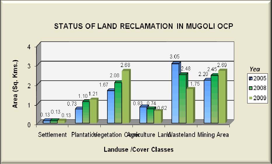
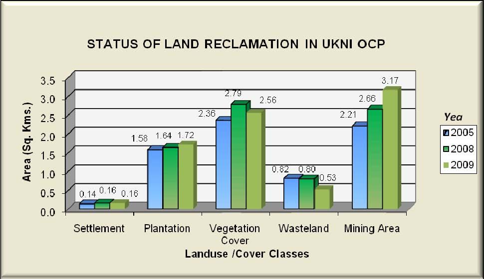
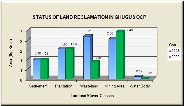
12 5.0 Land Reclamation Status in Western Coalfields Ltd. 5.1 Following 10 OC projects producing more than 5 million cubic m. (Coal + OB together) of Western Coalfields Ltd. have been taken up for land reclamation monitoring based on satellite data of the year-2009 : Sasti Padmapur Durgapur Mugoli Umrer Ukani Niljai New Majri Pimpalgaon Ghugus 5.2 Area statistics of different land use class present in OC projects in the year 2009 is given in Table 4.1. Land use maps derived from the satellite data is given in Plate no. 4.1 to Changes in land use status are shown in Fig Field photograph showing plantation on OB dump/backfilled area are also enclosed. 5.3 Study reveals that 86.28% of mining area has already been reclaimed by WCL out of which 46.14% area has been revegitated and 40.14% area are backfilled. 5.4 After analyzing the satellite data of year 2008 vs it is evident that plantation carried out on backfilled area, OB dumps as well as under social forestry in all the mines of WCL has increased from Sq. Km. to Sq. Km. in span of last one year. Whereas in span of last three year plantation has increased from Sq. Km (Yr.2005) to Sq. km. (Yr.2009). This substantial increase in the plantation area is due to the massive efforts taken up by WCL towards environmental protection. 6
13 5.5 Study indicates that coal mining in the above projects of WCL is limited to only 54.53% of the total mining leasehold area. 5.6 Study further reveals that about 86% of the total mined out area in the above projects are reclaimed and balance about 14% area is under active mining.. 7
14 TABLE 4.1 : STATUS OF LAND RECLAMATION IN WARDHA VALLEY COALFIELD BASED ON SATELLITE DATA OF THE YEAR 2009 Area in sq.km. Sasti OCP Padmapur OCP Durgapur OCP Mugoli OCP Umrer OCP Ukni OCP Neeljay OCP New Majri OCP Pimpalgaon OCP Ghugus OCP Area % Area % Area % Area % Area % Area % Area % Area % Area % Area % Dense Forest Open Forest Waterbodies Settlements Wastelands Agriculture Mining Area Vegetation Cover Scrubs Total Forest Social Forestry Plantation on OB/Backfill Total Plantation Total Vegetation(A) Coal Quarry Advance quarry site Barren OB Dump Barren backfilled area Coal Dump Waterfilled quarry Total Mining Area(B) Crop lands Fallow Land Total Agricultural( C) Wastelands Sand Body Total Wastelands(D) Urban Settlement Rural Settlement Industrial Settlement Total Settelements(E) Waterbodies(F) Total(A+B+C+D+E+F) Note : The colour of the classes correspond to the colours on the Land Use Map 8

15 Plate 4.1 9

16 Plate

17 Plate

18 Plate

19 Plate

20 Plate

21 Plate

22 Plate

23 Plate

24 Plate

25 Figure 4.1 Figure

26 Figure 4.3 Figure

27 Figure 4.5 Figure

28 Figure 4.7 Figure

29 Figure 4.9 Figure


30 Plantation on OB dump in Sasti OCP Plantation on OB dump in Ghugus OCP 24


31 Plantation on OB dump in Mugoli OCP Plantation on OB dump in New-Majri OCP 25

32 Plantation on Backfill in Niljai OCP Plantation on Backfill in Pimpalgaon OCP 26


33 Plantation on Backfill in Ukni OCP Plantation on Backfill in Umrer OCP 27


34 Plantation on OB Dump in Durgapur OCP Plantation on OB Dump in Padmapur OCP 28
35 Central Mine Planning & Design Institute Ltd. (A Subsidiary of Coal India Ltd.) Gondwana Place, Kanke Road, Ranchi , Jharkhand Phone : (+91) , , , FAX (+91) , Wesite : cmpdihq@cmpdi.co.in
Submitted to: Central Coalfields Limited Ranchi, Jharkhand. Ashoka & Piparwar OCPs, CCL
 Land Restoration / Reclamation Monitoring of more than 5 million cu. m. (Coal + OB) Capacity Open Cast Coal Mines of Central Coalfields Limited Based on Satellite Data for the Year 2013 Ashoka & Piparwar
Submitted to Central Coalfields Limited BHURKUNDA OCP, CCL
 Land Restoration / Reclamation Monitoring of Open Cast Coal Mines of Central Coalfields Limited producing less than 5 m cu m. (Coal+ OB) based on Satellite Data for the Year 2013 BHURKUNDA OCP, CCL Submitted
Coalfields Limited. Based on Satellite Data for the Year Central Coalfields Limited Ranchi, Jharkhand. Submitted to:
 Land Restoration / Reclamation Monitoring of less than 5 m cu. m. (Coal + OB) Capacity Open Cast Coal Mines of Central Coalfields Limited Based on Satellite Data for the Year 2011. N URIMARI (BIRSA) OCP,CCL
WESTERN COALFIELDS LIMITED
 Land Restoration / Reclamation Monitoring of less than 5 million Cu. M. (Coal+OB) Capacity Opencast Coal Mines of Western Coalfields Limited based on Satellite Data for the Year 2014 ERAI RIVER Coal Stock
Submitted to Western Coalfields Limited. I Inder UG to OC. Kamptee UG to OC
 Land Restoration / Reclamation Monitoring of Open Cast Coal Mines Less than 5 million cu.m. (OB+Coal) of Western Coalfields Ltd. Based on Satellite Data for the Year 2012 I Inder UG to OC Kamptee UG to
Land Restoration / Reclamation Monitoring of 50 Opencast Coal Mines of CIL producing more than 5 mcm (Coal+OB) based on Satellite Data for the Year
 based on Satellite Data for the Year") Land Restoration / Reclamation Monitoring of 50 Opencast Coal Mines of CIL producing more than 5 mcm (Coal+OB) based on Satellite Data for the Year 2014-15 Land Restoration / Reclamation Monitoring of
Land Restoration / Reclamation Monitoring of 50 Opencast Coal Mines of CIL producing more than 5 mcm (Coal+OB) based on Satellite Data for the Year 2014-15 Land Restoration / Reclamation Monitoring of
Land Restoration / Reclamation Monitoring of 50 Opencast Coal Mines of CIL producing more than 5 mcm (Coal+OB) based on Satellite Data for the Year
 based on Satellite Data for the Year") Land Restoration / Reclamation Monitoring of 50 Opencast Coal Mines of CIL producing more than 5 mcm (Coal+OB) based on Satellite Data for the Year 2013-14 Land Restoration / Reclamation Monitoring of
Land Restoration / Reclamation Monitoring of 50 Opencast Coal Mines of CIL producing more than 5 mcm (Coal+OB) based on Satellite Data for the Year 2013-14 Land Restoration / Reclamation Monitoring of
REPORT ON LAND USE/ VEGETATION COVER MAPPING OF BANDER COALFIELD OF WCL BASED ON REMOTE SENSING TECHNIQUE USING SATELLITE DATA OF 2012
 REPORT ON LAND USE/ VEGETATION COVER MAPPING OF BANDER COALFIELD OF WCL BASED ON REMOTE SENSING TECHNIQUE USING SATELLITE DATA OF 2012 March 2013 REPORT ON LAND USE/ VEGETATION COVER MAPPING OF BANDER
Report on Land Use / Vegetation Cover Mapping of Ib Valley Coalfield based on Satellite Data for the Year 2017 IB VALLEY COALFIELD
 Report on Land Use / Vegetation Cover Mapping of Ib Valley Coalfield based on Satellite Data for the Year 2017 IB VALLEY COALFIELD Submitted to Mahanadi Coalfields Limited Report on Land Use/ Vegetation
Land use/land cover Mapping of Jharia Coalfield based on Satellite Data of the Year March-2010
 Land use/land cover Mapping of Jharia Coalfield based on Satellite Data of the Year- 2008 March-2010 Remote Sensing Cell Geomatics Division CMPDI, Ranchi Document Control Sheet (1) Job No. RSC/561410027
Report on Land Use /Vegetation Cover Mapping of Singrauli Coalfield, NCL based on Remote Sensing Technique Year
 Report on Land Use /Vegetation Cover Mapping of Singrauli Coalfield, NCL based on Remote Sensing Technique Year-2012-13 Submitted to COAL INDIA LIMITED September 2012 Document Control Sheet List of Figures
REPORT ON Land use/vegetation cover Mapping of Rajmahal Coalfield based on Satellite data of the year Submitted to Eastern Coalfields Limited
 REPORT ON Land use/vegetation cover Mapping of Rajmahal Coalfield based on Satellite data of the year 2014 Submitted to Eastern Coalfields Limited Land use/vegetation cover Mapping of Rajmahal Coalfield
Abstract: About the Author:
 REMOTE SENSING AND GIS IN LAND USE PLANNING Sathees kumar P 1, Nisha Radhakrishnan 2 1 1 Ph.D Research Scholar, Department of Civil Engineering, National Institute of Technology, Tiruchirappalli- 620015,
Vegetation Cover Mapping of Kamptee Coalfield based on Satellite Data for the Year March-2017
 . CMPDI Vegetation Cover Mapping of Kamptee Coalfield based on Satellite Data for the Year- 2016 March-2017 Remote Sensing Cell Geomatics Division CMPDI, Ranchi Job No 5561410027 Page i . CMPDI Document
Environmental Impact Assessment Land Use and Land Cover CISMHE 7.1 INTRODUCTION
 7 LAND USE AND LAND COVER 7.1 INTRODUCTION The knowledge of land use and land cover is important for many planning and management activities as it is considered an essential element for modeling and understanding
7.1 INTRODUCTION 7.2 OBJECTIVE
 7 LAND USE AND LAND COVER 7.1 INTRODUCTION The knowledge of land use and land cover is important for many planning and management activities as it is considered as an essential element for modeling and
Abstract. TECHNOFAME- A Journal of Multidisciplinary Advance Research. Vol.2 No. 2, (2013) Received: Feb.2013; Accepted Oct.
 Received: Feb.2013; Accepted Oct.") Vol.2 No. 2, 83-87 (2013) Received: Feb.2013; Accepted Oct. 2013 Landuse Pattern Analysis Using Remote Sensing: A Case Study of Morar Block, of Gwalior District, M.P. Subhash Thakur 1 Akhilesh Singh 2
Vol.2 No. 2, 83-87 (2013) Received: Feb.2013; Accepted Oct. 2013 Landuse Pattern Analysis Using Remote Sensing: A Case Study of Morar Block, of Gwalior District, M.P. Subhash Thakur 1 Akhilesh Singh 2
Thematic Mapping in Siwani Area, District Bhiwani using Remote Sensing and Gis
 International Journal of Research in Geography (IJRG) Volume 3, Issue 2, 2017, PP 12-17 ISSN 2454-8685 (Online) DOI: http://dx.doi.org/10.20431/2454-8685.0302002 www.arcjournals.org Thematic Mapping in
Wastelands Analysis and Mapping of Bhiwani District, Haryana
 Wastelands Analysis and Mapping of Bhiwani District, Haryana Virender Sihag Research Scholar, Department of Geography, OPJS University, Churu, Rajasthan ABSTRACT This study aimed at monitoring, mapping,
FEBRUARY tis ... Po. III. Cll
 FEBRUARY 2010 ṯs....... ts Po. o Cll ~ ADVSORY BOARD 4 ndigenous knowledge validates GS outcome Purabl Chanda ndian Agricultural Research nstitute, ndia Dato' Dr. Abdul Kadir bin Taib Director General
LAND SUITABILITY STUDY IN LAND DEGRADED AREA DUE TO MINING IN DHANBAD DISTRICT, JHARKHAND.
 LAND SUITABILITY STUDY IN LAND DEGRADED AREA DUE TO MINING IN DHANBAD DISTRICT, JHARKHAND. Saranathan, E a*, Loveson, V.J b. and Victor Rajamanickam, G c a School of Civil Engineering, SASTRA, Thanjavur
CHAPTER VII FULLY DISTRIBUTED RAINFALL-RUNOFF MODEL USING GIS
 80 CHAPTER VII FULLY DISTRIBUTED RAINFALL-RUNOFF MODEL USING GIS 7.1GENERAL This chapter is discussed in six parts. Introduction to Runoff estimation using fully Distributed model is discussed in first
International Journal of Scientific Research and Reviews
 Case Study Available online www.ijsrr.org ISSN: 2279 0543 International Journal of Scientific Research and Reviews Study on the Pattern of Land Use /Land Cover Change in Sonipat District of NCR, A Block
UNITED NATIONS E/CONF.96/CRP. 5
 UNITED NATIONS E/CONF.96/CRP. 5 ECONOMIC AND SOCIAL COUNCIL Eighth United Nations Regional Cartographic Conference for the Americas New York, 27 June -1 July 2005 Item 5 of the provisional agenda* COUNTRY
1. Introduction. S.S. Patil 1, Sachidananda 1, U.B. Angadi 2, and D.K. Prabhuraj 3
 Cloud Publications International Journal of Advanced Remote Sensing and GIS 2014, Volume 3, Issue 1, pp. 525-531, Article ID Tech-249 ISSN 2320-0243 Research Article Open Access Machine Learning Technique
INTERNATIONAL JOURNAL OF GEOMATICS AND GEOSCIENCES Volume 2, No 1, 2011
 INTERNATIONAL JOURNAL OF GEOMATICS AND GEOSCIENCES Volume 2, No 1, 2011 Copyright 2010 All rights reserved Integrated Publishing services Research article ISSN 0976 4380 Spatio-Temporal changes of Land
Report on Land use/vegetation cover Mapping of North and South Karanpura Coalfields based on Satellite Data of the Year 2015
 Report on Land use/vegetation cover Mapping of North and South Karanpura Coalfields based on Satellite Data of the Year 2015 Submitted to Central Coalfields Ltd Ranchi Job No-561410027 [ Page i] Report
URBAN CHANGE DETECTION OF LAHORE (PAKISTAN) USING A TIME SERIES OF SATELLITE IMAGES SINCE 1972
 USING A TIME SERIES OF SATELLITE IMAGES SINCE 1972") URBAN CHANGE DETECTION OF LAHORE (PAKISTAN) USING A TIME SERIES OF SATELLITE IMAGES SINCE 1972 Omar Riaz Department of Earth Sciences, University of Sargodha, Sargodha, PAKISTAN. omarriazpk@gmail.com ABSTRACT
URBAN CHANGE DETECTION OF LAHORE (PAKISTAN) USING A TIME SERIES OF SATELLITE IMAGES SINCE 1972 Omar Riaz Department of Earth Sciences, University of Sargodha, Sargodha, PAKISTAN. omarriazpk@gmail.com ABSTRACT
Land Use and Land Cover Mapping and Change Detection in Jind District of Haryana Using Multi-Temporal Satellite Data
 Land Use and Land Cover Mapping and Change Detection in Jind District of Haryana Using Multi-Temporal Satellite Data Ravindra Prawasi, M.P. Sharma, T. P. Babu, Om Pal, Saroj, Kirti Yadav, R.S.Hooda Abstract
HIGH RESOLUTION SATELLITE DATA FOR LAND USE/LAND COVER MAPPING IN ROHTAK DISTRICT HARYANA, INDIA
 HIGH RESOLUTION SATELLITE DATA FOR LAND USE/LAND COVER MAPPING IN ROHTAK DISTRICT HARYANA, INDIA MR. MUKESH KUMAR 1 AND MR.SANDEEP KUMAR 2 1. M.tech. Student, Department of Geography, M.D.University Rohtak,
Geospatial Information for Urban Sprawl Planning and Policies Implementation in Developing Country s NCR Region: A Study of NOIDA City, India
 Geospatial Information for Urban Sprawl Planning and Policies Implementation in Developing Country s NCR Region: A Study of NOIDA City, India Dr. Madan Mohan Assistant Professor & Principal Investigator,
Monitoring and Temporal Study of Mining Area of Jodhpur City Using Remote Sensing and GIS
 Monitoring and Temporal Study of Mining Area of Jodhpur City Using Remote Sensing and GIS S. K Yadav 1, S. L Borana 2 1,2 Scientist, Remote Sensing Group, DL, Jodhpur-342011, Rajasthan, India ---------------------------------------------------------------------***---------------------------------------------------------------------
International Journal of Intellectual Advancements and Research in Engineering Computations
 ISSN:2348-2079 Volume-5 Issue-2 International Journal of Intellectual Advancements and Research in Engineering Computations Agricultural land investigation and change detection in Coimbatore district by
VILLAGE INFORMATION SYSTEM (V.I.S) FOR WATERSHED MANAGEMENT IN THE NORTH AHMADNAGAR DISTRICT, MAHARASHTRA
 FOR WATERSHED MANAGEMENT IN THE NORTH AHMADNAGAR DISTRICT, MAHARASHTRA") VILLAGE INFORMATION SYSTEM (V.I.S) FOR WATERSHED MANAGEMENT IN THE NORTH AHMADNAGAR DISTRICT, MAHARASHTRA Abstract: The drought prone zone in the Western Maharashtra is not in position to achieve the agricultural
VILLAGE INFORMATION SYSTEM (V.I.S) FOR WATERSHED MANAGEMENT IN THE NORTH AHMADNAGAR DISTRICT, MAHARASHTRA Abstract: The drought prone zone in the Western Maharashtra is not in position to achieve the agricultural
M.C.PALIWAL. Department of Civil Engineering NATIONAL INSTITUTE OF TECHNICAL TEACHERS TRAINING & RESEARCH, BHOPAL (M.P.), INDIA
, INDIA") INVESTIGATIONS ON THE ACCURACY ASPECTS IN THE LAND USE/LAND COVER MAPPING USING REMOTE SENSING SATELLITE IMAGERY By M.C.PALIWAL Department of Civil Engineering NATIONAL INSTITUTE OF TECHNICAL TEACHERS
INVESTIGATIONS ON THE ACCURACY ASPECTS IN THE LAND USE/LAND COVER MAPPING USING REMOTE SENSING SATELLITE IMAGERY By M.C.PALIWAL Department of Civil Engineering NATIONAL INSTITUTE OF TECHNICAL TEACHERS
Critical Assessment of Land Use Land Cover Dynamics Using Multi-Temporal Satellite Images
 Environments 2015, 2, 61-90; doi:10.3390/environments2010061 OPEN ACCESS environments ISSN 2076-3298 www.mdpi.com/journal/environments Article Critical Assessment of Land Use Land Cover Dynamics Using
INTERNATIONAL JOURNAL OF GEOMATICS AND GEOSCIENCES Volume 6, No 2, 2015
 INTERNATIONAL JOURNAL OF GEOMATICS AND GEOSCIENCES Volume 6, No 2, 2015 Copyright by the authors - Licensee IPA- Under Creative Commons license 3.0 Research article ISSN 0976 4380 An Analysis of Land use
International Journal of Scientific & Engineering Research, Volume 3, Issue 11, November ISSN
 International Journal of Scientific & Engineering Research, Volume 3, Issue 11, November-2012 1 ABSTRACT Land use land cover change detection of Ghatkesar mandal,rangareddy district using Remote sensing
Application of Remote Sensing Techniques for Change Detection in Land Use/ Land Cover of Ratnagiri District, Maharashtra
 IOSR Journal of Applied Geology and Geophysics (IOSR-JAGG) e-issn: 2321 0990, p-issn: 2321 0982.Volume 3, Issue 6 Ver. II (Nov. - Dec. 2015), PP 55-60 www.iosrjournals.org Application of Remote Sensing
A GIS approach to generation of thematic maps to monitor tea plantations: A case study
 Two and a Bud 59(2):41-45, 2012 RESEARCH PAPER. A GIS approach to generation of thematic maps to monitor tea plantations: A case study Minerva Saiki a I and R.M. Bhagat Department of Soils, Tocklai Experimental
GEOMATICS. Shaping our world. A company of
 GEOMATICS Shaping our world A company of OUR EXPERTISE Geomatics Geomatics plays a mayor role in hydropower, land and water resources, urban development, transport & mobility, renewable energy, and infrastructure
Land Administration and Cadastre
 Geomatics play a major role in hydropower, land and water resources and other infrastructure projects. Lahmeyer International s (LI) worldwide projects require a wide range of approaches to the integration
Journal of Telecommunications System & Management
 njournal of Telecommunicatio s System & Management Journal of Telecommunications System & Management Kota et al., J Telecommun Syst Manage 2017, 6:1 DOI: 10.4172/2167-0919.1000148 Research Article OMICS
International Journal of Scientific & Engineering Research, Volume 6, Issue 7, July ISSN
 International Journal of Scientific & Engineering Research, Volume 6, Issue 7, July-2015 1428 Accuracy Assessment of Land Cover /Land Use Mapping Using Medium Resolution Satellite Imagery Paliwal M.C &.
GEOSPATIAL TECHNOLOGY IN ENVIRONMENTAL IMPACT ASSESSMENTS RETROSPECTIVE.
 DOI 10.1515/pesd-2015-0031 PESD, VOL. 9, no. 2, 2015 GEOSPATIAL TECHNOLOGY IN ENVIRONMENTAL IMPACT ASSESSMENTS RETROSPECTIVE. Laxmi Goparaju 1 Key-words: Impact, geospatial, Mirzapur, dry deciduous thermal
Application of Remote Sensing and GIS in Seismic Surveys in KG Basin
 P-318 Summary Application of Remote Sensing and GIS in Seismic Surveys in KG Basin M.Murali, K.Ramakrishna, U.K.Saha, G.Sarvesam ONGC Chennai Remote Sensing provides digital images of the Earth at specific
Identification of Land use and Land cover Changes using Remote Sensing and GIS
 Identification of Land use and Land cover Changes using Remote Sensing and GIS N. Nagarajan and. S. Poongothai Abstract This study reveals to identify the changes of land use/land cover of rural agricultural
INVESTIGATION LAND USE CHANGES IN MEGACITY ISTANBUL BETWEEN THE YEARS BY USING DIFFERENT TYPES OF SPATIAL DATA
 INVESTIGATION LAND USE CHANGES IN MEGACITY ISTANBUL BETWEEN THE YEARS 1903-2010 BY USING DIFFERENT TYPES OF SPATIAL DATA T. Murat Celikoyan, Elif Sertel, Dursun Zafer Seker, Sinasi Kaya, Uğur Alganci ITU,
A Case Study of Using Remote Sensing Data and GIS for Land Management; Catalca Region
 A Case Study of Using Remote Sensing Data and GIS for Land Management; Catalca Region Dr. Nebiye MUSAOGLU, Dr. Sinasi KAYA, Dr. Dursun Z. SEKER and Dr. Cigdem GOKSEL, Turkey Key words: Satellite data,
URBAN WATERSHED RUNOFF MODELING USING GEOSPATIAL TECHNIQUES
 URBAN WATERSHED RUNOFF MODELING USING GEOSPATIAL TECHNIQUES DST Sponsored Research Project (NRDMS Division) By Prof. M. GOPAL NAIK Professor & Chairman, Board of Studies Email: mgnaikc@gmail.com Department
Remote Sensing and GIS Application in Change Detection Study Using Multi Temporal Satellite
 Cloud Publications International Journal of Advanced Remote Sensing and GIS 2013, Volume 2, Issue 1, pp. 374-378, Article ID Tech-181 ISSN 2320-0243 Case Study Open Access Remote Sensing and GIS Application
Landuse and Landcover change analysis in Selaiyur village, Tambaram taluk, Chennai
 Landuse and Landcover change analysis in Selaiyur village, Tambaram taluk, Chennai K. Ilayaraja Department of Civil Engineering BIST, Bharath University Selaiyur, Chennai 73 ABSTRACT The synoptic picture
GIS BASED OPTIMAL ROUTE ANALYSIS FOR THE TRANSPORTATION OF SOLID WASTE- A CASE STUDY FROM HYDERABAD CITY
 GIS BASED OPTIMAL ROUTE ANALYSIS FOR THE TRANSPORTATION OF SOLID WASTE- A CASE STUDY FROM HYDERABAD CITY Ramesh Kumar.R 1, Prof. Ch. Ramakrishna 2 1,2 Department of Environmental Studies, GITAM University,
Report for Area Drainage Studies for 1320 MW (2x660 MW) THERMAL POWER PROJECT AT MIRZAPUR, U.P.
 THERMAL POWER PROJECT AT MIRZAPUR, U.P.") Report for Area Drainage Studies for 1320 MW (2x660 MW) THERMAL POWER PROJECT AT MIRZAPUR, U.P. 1. Introduction M/s Welspun Energy Uttar Pradesh Ltd. (WEUPL) is putting up 1320 MW (2 x 660 MW) coal fired
Report for Area Drainage Studies for 1320 MW (2x660 MW) THERMAL POWER PROJECT AT MIRZAPUR, U.P. 1. Introduction M/s Welspun Energy Uttar Pradesh Ltd. (WEUPL) is putting up 1320 MW (2 x 660 MW) coal fired
An Investigation into Land Use and Land Cover Change through Object Based Classification (A Case Study of South Haldwani, Uttarakhand, India)
") International Journal of Humanities and Social Science Invention (IJHSSI) ISSN (Online): 2319 7722, ISSN (Print): 2319 7714 Volume 7 Issue 03 Ver. II March. 2018 PP.50-58 An Investigation into Land Use
International Journal of Humanities and Social Science Invention (IJHSSI) ISSN (Online): 2319 7722, ISSN (Print): 2319 7714 Volume 7 Issue 03 Ver. II March. 2018 PP.50-58 An Investigation into Land Use
Investigation of the Effect of Transportation Network on Urban Growth by Using Satellite Images and Geographic Information Systems
 Presented at the FIG Congress 2018, May 6-11, 2018 in Istanbul, Turkey Investigation of the Effect of Transportation Network on Urban Growth by Using Satellite Images and Geographic Information Systems
APPLICATION OF LAND CHANGE MODELER FOR PREDICTION OF FUTURE LAND USE LAND COVER A CASE STUDY OF VIJAYAWADA CITY
 APPLICATION OF LAND CHANGE MODELER FOR PREDICTION OF FUTURE LAND USE LAND COVER A CASE STUDY OF VIJAYAWADA CITY K. Sundara Kumar 1, Dr. P. Udaya Bhaskar 2, Dr. K. Padmakumari 3 1 Research Scholar, 2,3
Effect of land use/land cover changes on runoff in a river basin: a case study
 Water Resources Management VI 139 Effect of land use/land cover changes on runoff in a river basin: a case study J. Letha, B. Thulasidharan Nair & B. Amruth Chand College of Engineering, Trivandrum, Kerala,
Plantations Mapping of Dabwali, Rania and Ellenabad blocks of Sirsa District Using on Screen Visual Interpretation Approach on WV-2 Data
 s Mapping of Dabwali, Rania and Ellenabad blocks of Sirsa District Using on Screen Visual Interpretation Approach on WV-2 Data Savita 1, Veena 2, Reetu Sharma 3 Haryana Space Applications Centre (HARSAC),
EFFECT OF WATERSHED DEVELOPMENT PROGRAMME IN GUDHA GOKALPURA VILLAGE, BUNDI DISTRICT, RAJASTHAN - A REMOTE SENSING STUDY
 EFFECT OF WATERSHED DEVELOPMENT PROGRAMME IN GUDHA GOKALPURA VILLAGE, BUNDI DISTRICT, RAJASTHAN - A REMOTE SENSING STUDY G. Sajeevan, C. P. Johnson, D. J. Pal and B. K. Kakade* C-DAC, Pune University Campus,
An Automated Object-Oriented Satellite Image Classification Method Integrating the FAO Land Cover Classification System (LCCS).
.") An Automated Object-Oriented Satellite Image Classification Method Integrating the FAO Land Cover Classification System (LCCS). Ruvimbo Gamanya Sibanda Prof. Dr. Philippe De Maeyer Prof. Dr. Morgan De
An Automated Object-Oriented Satellite Image Classification Method Integrating the FAO Land Cover Classification System (LCCS). Ruvimbo Gamanya Sibanda Prof. Dr. Philippe De Maeyer Prof. Dr. Morgan De
Deriving Uncertainty of Area Estimates from Satellite Imagery using Fuzzy Land-cover Classification
 International Journal of Information and Computation Technology. ISSN 0974-2239 Volume 3, Number 10 (2013), pp. 1059-1066 International Research Publications House http://www. irphouse.com /ijict.htm Deriving
VEGETATION ANALYSIS AND LAND USE LAND COVER CLASSIFICATION OF FOREST IN UTTARA KANNADA DISTRICT INDIA USING REMOTE SENSIGN AND GIS TECHNIQUES
 VEGETATION ANALYSIS AND LAND USE LAND COVER CLASSIFICATION OF FOREST IN UTTARA KANNADA DISTRICT INDIA USING REMOTE SENSIGN AND GIS TECHNIQUES A.G. Koppad a, B S Janagoudar b a Professor and Head (NRM),
Land Resources Expansion Monitoring and Management: A RS-GIS Approach
 International Journal of Scientific and Research Publications, Volume 2, Issue 10, October 2012 1 Land Resources Expansion Monitoring and Management: A RS-GIS Approach Ajay Singh Tomar *, U. C.Singh **
Geographic Resources Decision Support System for land use, land cover dynamics analysis
 Proceedings of the FOSS/GRASS Users Conference - Bangkok, Thailand, 12-14 September 2004 Geographic Resources Decision Support System for land use, land cover dynamics analysis T. V. Ramachandra*+, Uttam
Urban Sprawl Mapping and Landuse Change Detection in and around Udupi Town: A Remote Sensing based Approach
 Urban Sprawl Mapping and Landuse Change Detection in and around Udupi Town: A Remote Sensing based Approach 1 K. Silambarasan, 2 M. S. Vinaya, 3 S. Suresh Babu 1,2,3 Department of Civil Engineering, 1,2,3
Use of Corona, Landsat TM, Spot 5 images to assess 40 years of land use/cover changes in Cavusbasi
 New Strategies for European Remote Sensing, Olui (ed.) 2005 Millpress, Rotterdam, ISBN 90 5966 003 X Use of Corona, Landsat TM, Spot 5 images to assess 40 years of land use/cover changes in Cavusbasi N.
Land Use Change Detection in Baragaon Block, Varanasi District Using Remote Sensing
 International Journal of Engineering Science Invention ISSN (Online): 2319 6734, ISSN (Print): 2319 6726 Volume 2 Issue 7ǁ July. 2013 ǁ PP.49-53 Land Use Change Detection in Baragaon Block, Varanasi District
Urban Hydrology - A Case Study On Water Supply And Sewage Network For Madurai Region, Using Remote Sensing & GIS Techniques
 RESEARCH INVENTY: International Journal of Engineering and Science ISBN: 2319-6483, ISSN: 2278-4721, Vol. 1, Issue 8 (November 2012), PP 07-12 www.researchinventy.com Urban Hydrology - A Case Study On
International Journal of Advancements in Research & Technology, Volume 2, Issue 7, July ISSN
 International Journal of Advancements in Research & Technology, Volume 2, Issue 7, July-2013 34 Remote Sensing & GIS Tools for Urban Studies in Akola city, Maharashtra. Khadri, S.F.R Chaitanya Pande and
CHAPTER 4 METHODOLOGY
 71 CHAPTER 4 METHODOLOGY 4.1 GENERAL Drought, a vague phenomenon, has been defined and analyzed in various ways. Drought assessment involves analysis of spatially and temporally varying water related data.
AN INVESTIGATION OF AUTOMATIC CHANGE DETECTION FOR TOPOGRAPHIC MAP UPDATING
 AN INVESTIGATION OF AUTOMATIC CHANGE DETECTION FOR TOPOGRAPHIC MAP UPDATING Patricia Duncan 1 & Julian Smit 2 1 The Chief Directorate: National Geospatial Information, Department of Rural Development and
Quality and Coverage of Data Sources
 Quality and Coverage of Data Sources Objectives Selecting an appropriate source for each item of information to be stored in the GIS database is very important for GIS Data Capture. Selection of quality
Progress and Land-Use Characteristics of Urban Sprawl in Busan Metropolitan City using Remote sensing and GIS
 Progress and Land-Use Characteristics of Urban Sprawl in Busan Metropolitan City using Remote sensing and GIS Homyung Park, Taekyung Baek, Yongeun Shin, Hungkwan Kim ABSTRACT Satellite image is very usefully
ART Based Reliable Method for Prediction of Agricultural Land Changes Using Remote Sensing
 Circuits and Systems, 2016, 7, 1051-1067 Published Online May 2016 in SciRes. http://www.scirp.org/journal/cs http://dx.doi.org/10.4236/cs.2016.76089 ART Based Reliable Method for Prediction of Agricultural
Abstract. 1. Introduction. 2. Materials and Methods. 2.1 Study Area
 Land Use and Land Cover Mapping by using Remote Sensing and GIS Techniques a Case Study of Kasaba Hobli, Hoskote Taluk, Bangalore Rural District, Karnataka, India. Prof. Dr. P. K. Srimani, F.N.A.Sc., Prof
Table 4.1 Images used for the Study. Spatial Resolution (Meter) Resolution (Bits) 30 (For 6th band 120)
 Resolution (Bits) 30 (For 6th band 120)")
Mapping and Spatial Characterisation of Major Urban Centres in Parts of South Eastern Nigeria with Nigeriasat-1 Imagery
 Mapping and Spatial Characterisation of Major Urban Centres in Parts of South Eastern Nigeria with Joel I. IGBOKWE, Nigeria Key words: Urban Planning, Urban growth, Urban Infrastructure, Landuse, Satellite
Dr. S.SURIYA. Assistant professor. Department of Civil Engineering. B. S. Abdur Rahman University. Chennai
 Hydrograph simulation for a rural watershed using SCS curve number and Geographic Information System Dr. S.SURIYA Assistant professor Department of Civil Engineering B. S. Abdur Rahman University Chennai
Application of Geographical Information System (GIS) tools in watershed analysis
 tools in watershed analysis") Application of Geographical Information System (GIS) tools in watershed analysis Paritosh Gupta 1, Damanjit S Minhas 2, Rajendra M Tamhane 1, A K Mookerjee 2 1.ESRI India New Delhi 2. LEA Associates South
Application of Geographical Information System (GIS) tools in watershed analysis Paritosh Gupta 1, Damanjit S Minhas 2, Rajendra M Tamhane 1, A K Mookerjee 2 1.ESRI India New Delhi 2. LEA Associates South
GIS Based Delineation of Micro-watershed and its Applications: Mahendergarh District, Haryana
 Kamla-Raj 2012 J Hum Ecol, 38(2): 155-164 (2012) GIS Based Delineation of Micro-watershed and its Applications: Mahendergarh District, Haryana Gulshan Mehra and Rajeshwari * Department of Geography, Kurukshetra
PREDICTION OF FUTURE LAND USE LAND COVER CHANGES OF VIJAYAWADA CITY USING REMOTE SENSING AND GIS
 PREDICTION OF FUTURE LAND USE LAND COVER CHANGES OF VIJAYAWADA CITY USING REMOTE SENSING AND GIS K. Sundara Kumar 1 *, N V A Sai Sankar Valasala 2, J V Subrahmanyam V 3, Mounika Mallampati 4 Kowsharajaha
Favorable potential zone map using Remote sensing and GIS
 Favorable potential zone map using Remote sensing and GIS M. Devarajan & S.Mohan GIS Cell, Hydrogeology Wing Tamilnadu Water Supply and Drainage Board, Chennai Abstract: TWAD Board is shouldering the responsibility
Pipeline Routing Using Geospatial Information System Analysis
 Pipeline Routing Using Geospatial Information System Analysis Mahmoud Reza 1 Delavar and Fereydoon 2 Naghibi 1-Assistance Professor, Dept. of Surveying and Geomatic Eng., Eng. Faculty, University of Tehran,
COAL EXPLORATION & RESOURCES
 COAL EXPLORATION & RESOURCES Chapter-3 3.1 INTRODUCTION Exploration for Coal in the country is carried out in two broad stages i.e. the Regional Exploration and Detailed Exploration. The regional exploration
Dr.N.Chandrasekar Professor and Head Centre for GeoTechnology Manonmaniam Sundaranar University Tirunelveli
 Classification and Segmentation of Coastal Landforms in the South Tamilnadu Coast Dr.N.Chandrasekar Professor and Head Centre for GeoTechnology Manonmaniam Sundaranar University Tirunelveli E-mail: profncsekar@gmail.com
UNION TERRITORIES Daman Diu Lakshadweep Karaikal Mahe Pondicherry Yanam Total
 Category Andaman & Nicobar Chandigarh Dadra & Nagar Haveli Table 66: Distribution of Wastelands UNION TERRITORIES Daman Diu Lakshadweep Karaikal Mahe Pondicherry Yanam Total 1 0.00 0.08 0.01 0.16 0.00
INTERNATIONAL JOURNAL OF GEOMATICS AND GEOSCIENCES Volume 4, No 2, 2013
 INTERNATIONAL JOURNAL OF GEOMATICS AND GEOSCIENCES Volume 4, No 2, 2013 Copyright 2010 All rights reserved Integrated Publishing services Research article ISSN 0976 4380 Evaluation of landuse / landcover
STEREO ANALYST FOR ERDAS IMAGINE Stereo Feature Collection for the GIS Professional
 STEREO ANALYST FOR ERDAS IMAGINE Stereo Feature Collection for the GIS Professional STEREO ANALYST FOR ERDAS IMAGINE Has Your GIS Gone Flat? Hexagon Geospatial takes three-dimensional geographic imaging
Accuracy Assessment of Land Cover Classification in Jodhpur City Using Remote Sensing and GIS
 Accuracy Assessment of Land Cover Classification in Jodhpur City Using Remote Sensing and GIS S.L. Borana 1, S.K.Yadav 1 Scientist, RSG, DL, Jodhpur, Rajasthan, India 1 Abstract: A This study examines
Using GIS and Remote Sensing Technique for Zoning of Wastewater Drainage of Allahabad City
 Cloud Publications International Journal of Advanced Remote Sensing and GIS 2015, Volume 4, Issue 1, pp. 1419-1434, Article ID Tech-489 ISSN 2320-0243 Research Article Open Access Using GIS and Remote
ARCH PROJET Activity 1 -Synthesis-
 ARCH PROJET Activity 1 -Synthesis- CONTENT 1 ARCH project context... 3 1.1. General context... 3 1.2. The ARCH Project... 3 1.3. The Project ARCH partners... 3 1.4. The ARCH project content... 4 2 Activity
Application of Remote Sensing and GIS for Identification and Assessment Proceedings of AIPA 2012, INDIA 79
 Application of Remote Sensing and GIS for Identification and Assessment Proceedings of AIPA 2012, INDIA 79 APPLICATION OF REMOTE SENSING AND GIS FOR IDENTIFICATION AND ASSESSMENT OF CROP GROWTH IN WAZIRABAD
Spanish national plan for land observation: new collaborative production system in Europe
 ADVANCE UNEDITED VERSION UNITED NATIONS E/CONF.103/5/Add.1 Economic and Social Affairs 9 July 2013 Tenth United Nations Regional Cartographic Conference for the Americas New York, 19-23, August 2013 Item
THE REVISION OF 1:50000 TOPOGRAPHIC MAP OF ONITSHA METROPOLIS, ANAMBRA STATE, NIGERIA USING NIGERIASAT-1 IMAGERY
 I.J.E.M.S., VOL.5 (4) 2014: 235-240 ISSN 2229-600X THE REVISION OF 1:50000 TOPOGRAPHIC MAP OF ONITSHA METROPOLIS, ANAMBRA STATE, NIGERIA USING NIGERIASAT-1 IMAGERY 1* Ejikeme, J.O. 1 Igbokwe, J.I. 1 Igbokwe,
Terrain Analysis through Maps.
 Terrain Analysis through Maps Need for Maps Theodolite Every Inch on Earth is Measured Maps are Prepared based on these Measurements Classification of Maps Function Scale Physical (Natural Features)
GIS FOR MAZOWSZE REGION - GENERAL OUTLINE
 GIS FOR MAZOWSZE REGION - GENERAL OUTLINE S. Bialousz 1), K Mączewski 2), E. Janczar 2), K. Osinska-Skotak 1) 1) Warsaw University of Technology, Warsaw, Poland 2) Office of the Surveyor of the Mazowieckie
CHAPTER - IV METHODOLOGY
 46 4.1 GENERAL CHAPTER - IV METHODOLOGY This chapter describes the methodology adopted in this research. This methodology includes data collection, data preprocessing and image classification using object
Preparation of LULC map from GE images for GIS based Urban Hydrological Modeling
 International Conference on Modeling Tools for Sustainable Water Resources Management Department of Civil Engineering, Indian Institute of Technology Hyderabad: 28-29 December 2014 Abstract Preparation
GROUNDWATER CONFIGURATION IN THE UPPER CATCHMENT OF MEGHADRIGEDDA RESERVOIR, VISAKHAPATNAM DISTRICT, ANDHRA PRADESH
 GROUNDWATER CONFIGURATION IN THE UPPER CATCHMENT OF MEGHADRIGEDDA RESERVOIR, VISAKHAPATNAM DISTRICT, ANDHRA PRADESH Prof.P.Jagadeesara Rao Department of Geo-Engineering and Centre for Remote Sensing, College