Land use/land cover Mapping of Jharia Coalfield based on Satellite Data of the Year March-2010
|
|
|
- Delphia Pitts
- 5 years ago
- Views:
Transcription
1
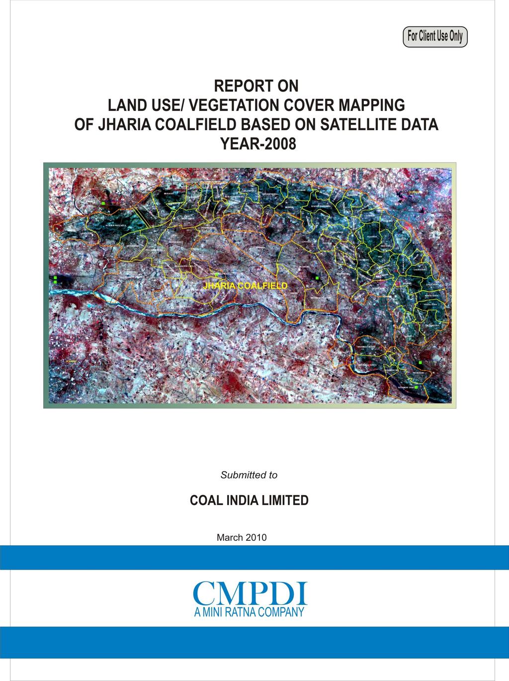
2 Land use/land cover Mapping of Jharia Coalfield based on Satellite Data of the Year March-2010 Remote Sensing Cell Geomatics Division CMPDI, Ranchi
3 Document Control Sheet (1) Job No. RSC/ (2) Publication Date March 2010 (3) Number of Pages 28 (4) Number of Figures 7 (5) Number of Tables 6 (6) Number of Plates 2 (7) Title of Report Land use / cover mapping of Jharia Coalfield on satellite data for the year (8) Aim of the Report To prepare Land use / cover map of Jharia Coalfield on 1:50000 scale for creating the environmental data base for land, vegetation cover, drainage,surface water and infrastructure. (9) Executing Unit Remote Sensing Cell, Geomatics Division Central Mine Planning & Design Institute Limited, Gondwana Place, Kanke Road, Ranchi (10) User Agency Coal India Ltd.(CIL) / Bharat Coking Coal Ltd.(BCCL) (11) Authors Mr Rajneesh Kumar, SE (Remote Sensing) Mr. N.P.Singh, Dy.C.G Mr. V.K.Gupta, GM (Geomatics) (12) Security Restriction Restricted Circulation (13) No. of Copies 5 (14) Distribution Statement Official ii
4 Document Control Sheet List of Figures List of Tables List of Plates Contents Page No. ii iv iv iv 1.0 Introduction Project Reference 1.2 Project Background 1.3 Objectives 1.4 Location and Accessibility 1.5 Physiography 2.0 Remote Sensing Concept & Methodology Remote Sensing 2.2 Electromagnetic Spectrum 2.3 Scanning System 2.4 Data Source 2.5 Characteristics of Satellite/Sensor 2.6 Data Processing Geometric Correction, rectification & geo-referencing Image enhancement Training set selection Signature generation & classification Creation / Overlay of vector database in GIS Validation of classified image 3.0 Landuse / Cover Mapping Introduction 3.2 Landuse / Cover Classification 3.3 Data Analysis & Change Detection Vegetation Cover Mining Area Agricultural Land Wasteland Settlements Water Bodies 4.0 Conclusion and Recommendations Conclusion 4.2 Recommendations iii
5 List of Figures 2.0 Location Map of Jharia Coal Field. 2.1 Remote Sensing Radiation system 2.2 Electromagnetic Spectrum. 2.3 Expanded diagram of the visible and infrared regions (upper) and microwave regions (lower) showing atmospheric windows. 2.4 Methodology for Land use / Cover mapping. 2.5 Geoid-Ellipsoid -Projection Relationship. 3.1 Area-wise percentage of different land use/cover in coalfield. List of Tables 2.1 Electromagnetic spectral regions. 2.2 Characteristics of the satellite/sensor used in the present project work. 2.3: Classification Accuracy Matrix. 3.1 Vegetation cover / land use classes identified in Jharia Coalfield. 3.2 Distribution of Land use / Cover Patten in Jharia Coalfield in the year Vegetation Cover in Jharia Coalfield 3.4 Distribution of Mining area in Jharia Coalfield during the year Agricultural Land in Jharia Coalfield during the year Wastelands in Jharia coalfileds during the year Distribution of Settlements in Jharia Coalfield during the year 2008 List of Plates List of maps/plates prepared on a scale of 1:50,000 are given below: 1. Plate No. HQ/REM/ 001: IRS-P6/ LISS-III FCC of Jharia Coalfield 2. Plate No. HQ/REM/ 002: Landuse / Cover Map of Jharia Coalfield based on IRS P6/ LISS-III data of January iv
6 Chapter 1 Introduction 1.1 Project Reference In view of creating the geo-environmental data base of coalfields for monitoring the impact of coal mining on land use and vegetation cover, Chairman, Coal India Ltd.(CIL) directed Central mine Planning & Design Institute (CMPDI) to take up the study based on satellite data using Remote Sensing technique. Accordingly, a road map for implementation of the project was submitted to Coal India Ltd. for land use and vegetation cover mapping of 28 major coalfields at regular interval of three years for creating the environmental data base. In pursuant to the work order no.cil/wbp/env/2009/2428 dated ; land use/vegetation cover mapping of Jharia coalfield based on satellite data was taken up to create the geo-environmental data base for assessing the impact of coal mining on land and vegetation cover at regular interval of three years Objective The objective of the present study is to prepare a regional land use and vegetation cover map of Jharia coalfield on 1:50,000 scale based on satellite data of the year 2008, using digital image processing technique for creating the geo-environmental data base in respect of land use, vegetation cover, drainage, mining area, infrastructure etc. and regular up-dation of database at regular interval of three years to assess the impact of coal mining and other industrial activities on land use and vegetation cover in the coalfield area. 1.4 Location of the Area & Accessibility The Jharia Coalfield (JCF) is located in the north east part of the State of Job No Chapter -1 Page 1
7 Jharkhand, approximately 260 km west of Kolkata. It is linked to Kolkata and Delhi through NH 2, which is the part of Golden Quadrilateral highway network of India. The coalfield contains proven coal reserves of approximately one billion tonnes in a crescent-shaped basin of approximately 400 km 2. BCCL operates within an area of approximately 258 Sq km. The Jharia coalfield covers an area of about 393 sq km. it is bounded by Lat N and N and Long E and E. The major part of coalfield (about 400 sq km) lies in Dhanbad district of Jharkhand. Coalfield is connected by Major Highways road with Ranchi (117 km), Asansol (60 km), Jamshedpur (108 km) and Dhanbad (8 km). The nearest major railway station is Dhanbad, located on Delhi-Howrah Grand Chord line oh East Central Railway which passes parallel to northern boundary of the coalfield. 1.5 Physiography Jharia coalfield is characterized by gently undulating to a rolling topography with an overall slope towards east-southeast. The coalfield is roughly sickle shaped on plan and occurs as a basin with its axis trending broadly east-west and plunging towards the west. The southern flank is truncated by a major Boundary Fault. The general dip of the formation is 10 to 15 degrees. Flatter dips have also been noted at places. The entire southern part of Jharia coalfield in the vicinity of the Boundary Fault, however shows generally steep dipping beds with amounts increasing even up to 70 degrees. The strike of the formation is generally WSW to ENE in the western part and WNW to ESE in the southern part of the coalfield. This gradually swings to EW in the centre of the coalfield and then to NS further east. In the south-eastern part the strike is generally WNW-ESE. Besides the boundary part the coalfield is traversed by a number of other major and minor faults. Job No Chapter -1 Page 2
8 The Barakar formation contains 18 standard coal horizons (numbered I to XVIII). Of the Barakar formations, the coal seams XIII and above are generally thin and of relatively superior quality. Seams XII to IX/X are of medium to superior quality and attain sizable thickness at places. The V,VI,VII,IV, III & II are generally thick seams of inferior quality. The bottom most seam I is of superior medium coking quality in the eastern part of the coalfield. The drainage pattern in the Jharia coalfield is dendritic in nature. This may be due to more or less homogeneous lithology and structural controls. Damodar river is the main control of drainage system along the Jharia coalfield. It is a fourth order stream to which a number of third to first order streams, viz. Jamunia, Khudia, Katri, Ekra, Tisra, Chatkari etc. join. Damodar river flows along the southern periphery of the coalfield and is guided by the Great Boundary Fault. The main flow direction is from west to east.. A map of India showing the location of Jharia Coalfield is given in Fig1.1. Job No Chapter -1 Page 3


9 Fig 1.1 : Map of India Showing the Location of Jharia Coalfields Job No Chapter -1 Page 4
10 Chapter 2 Remote Sensing Concepts and Methodology 2.1 Remote Sensing Remote sensing is the science and art of obtaining information about an object or area through the analysis of data acquired by a device that is not in physical contact with the object or area under investigation. The term remote sensing is commonly restricted to methods that employ electromagnetic energy (such as light, heat and radio waves) as the means of detecting and measuring object characteristics. All physical objects on the earth surface continuously emit electromagnetic radiation because of the oscillations of their atomic particles. Remote sensing is largely concerned with the measurement of electromagnetic energy from the SUN, which is reflected, scattered or emitted by the objects on the surface of the earth. Figure 2.1 schematically illustrate the generalised processes involved in electromagnetic remote sensing of the earth resources. Job No Chapter-2 Page 5
11 2.2 Electromagnetic Spectrum The electromagnetic (EM) spectrum is the continuum of energy that ranges from meters to nanometres in wavelength and travels at the speed of light. Different objects on the earth surface reflect different amounts of energy in various wavelengths of the EM spectrum. Figure 2.2 shows the electromagnetic spectrum, which is divided on the basis of wavelength into different regions that are described in Table 2.1. The EM spectrum ranges from the very short wavelengths of the gamma-ray region to the long wavelengths of the radio region. The visible region ( µm wavelengths) occupies only a small portion of the entire EM spectrum. Energy reflected from the objects on the surface of the earth is recorded as a function of wavelength. During daytime, the maximum amount of energy is reflected at 0.5µm wavelengths, which corresponds to the green band of the visible region, and is called the reflected energy peak (Figure 2.2). The earth also radiates energy both day and night, with the maximum energy 9.7µm wavelength. This radiant energy peak occurs in the thermal band of the IR region (Figure 2.2). Job No Chapter-2 Page 6
12 Job No Chapter-2 Page 7 CMPDI
13 Table 2.1 Electromagnetic spectral regions Region Wavelength Remarks Gamma ray < 0.03 nm Incoming radiation is completely absorbed by the upper atmosphere and is not available for remote sensing. X-ray 0.03 to 3.00 nm Completely absorbed by atmosphere. Not employed in remote sensing. Ultraviolet 0.03 to 0.40 µm Incoming wavelengths less than 0.3mm are completely absorbed by Ozone in the upper atmosphere. Photographic UV band 0.30 to 0.40 µm Transmitted through atmosphere. Detectable with film and photo detectors, but atmospheric scattering is severe. Visible 0.40 to 0.70 µm Imaged with film and photo detectors. IBCCLudes reflected energy peak of earth at 0.5mm. Infrared 0.70 to µm Interaction with matter varies with wavelength. Absorption bands separate atmospheric transmission windows. Reflected IR band 0.70 to 3.00 µm Reflected solar radiation that contains no information about thermal properties of materials. The band from mm is detectable with film and is called the photographic IR band. Thermal IR band to to µm µm Principal atmospheric windows in the thermal region. Images at these wavelengths are acquired by optical-mechanical scanners and special Videocon systems but not by film. Microwave 0.10 to cm Longer wavelengths can penetrate clouds, fog and rain. Images may be acquired in the active or passive mode. Radar 0.10 to cm Active form of microwave remote sensing. Radar images are acquired at various wavelength bands. Radio > cm Longest wavelength portion of electromagnetic spectrum. Some classified radars with very long wavelength operate in this region. The earth's atmosphere absorbs energy in the gamma-ray, X-ray and most of the ultraviolet (UV) region; therefore, these regions are not used for remote sensing. Details of these regions are shown in Figure 2.3. The horizontal axes show wavelength on a logarithmic scale; the vertical axes show percent atmospheric transmission of EM energy. Wavelength regions with high transmission are called atmospheric windows and are used to acquire remote sensing data. The major remote sensing records energy only in the visible, infrared and micro-wave regions. Detection and measurement of the recorded energy enables identification of surface objects (by their characteristic wavelength patterns or spectral signatures), both from air-borne and space-borne platforms. Job No Chapter-2 Page 8
14 2.3 Scanning System The sensing device in a remotely placed platform (aircraft/satellite) records EM radiation using a scanning system. In scanning system, a sensor, with a narrow field of view is employed; this sweeps across the terrain to produce an image. The sensor receives electromagnetic energy radiated or reflected from the terrain and converts them into signal that is recorded as numerical data. In a remote sensing satellite, multiple arrays of linear sensors are used, with each array recording simultaneously a separate band of EM energy. The array of sensors employs a spectrometer to disperse the incoming energy into a spectrum. Sensors (or detectors) are positioned to record specific wavelength bands of energy. The information received by the sensor is suitably manipulated and transported back to the ground receiving station. The data are reconstructed on ground into digital images. The digital image data on magnetic/optical media consist of picture elements arranged in regular rows and columns. The position of any picture element, pixel, is determined on a x-y co-ordinate system. Each pixel has a numeric value, called digital number (DN), which records the intensity of electromagnetic energy measured for the ground resolution cell represented by that pixel. The range of digital numbers in an image data is controlled by the radiometric resolution of the satellite s sensor system. The digital image data are further processed to produce master images of the study area. By analysing the digital data/imagery, digitally/visually, it is possible to detect, identify and classify various objects and phenomenon on the earth surface. Remote sensing technique provides an efficient, speedy and cost-effective method for assessing the changes in vegetation cover certain period of time due to its inherited capabilities of being multi-spectral, repetitive and synoptic aerial coverage. Job No Chapter-2 Page 9
15 2.4 Data Source The following data are used in the present study: Primary Data Raw satellite data, obtained from National Remote Sensing Centre (NRSC), Hyderabad, as follows, was used as primary data source for the study. IRS P6/ LISS III; Band 2,3,4,5; Path # 106, Row # 055; Date of pass *. The detail specification of the data is also given in Table 2.2. Secondary Data Secondary (ancillary) and ground data constitute important baseline information in remote sensing, as they improve the interpretation accuracy and reliability of remotely sensed data by enabling verification of the interpreted details and by supplementing it with the information that cannot be obtained directly from the remotely sensed data. 2.5 Characteristics of Satellite/Sensor The basic properties of a satellite s sensor system can be summarised as: (a) Spectral coverage/resolution, i.e., band locations/width; (b) spectral dimensionality: number of bands; (c) radiometric resolution: quantisation; (d) spatial resolution/instantaneous field of view or IFOV; and (e) temporal resolution. Table 2.2 illustrates the basic properties of IRS-P6 satellite/sensor that is used in the present study. Job No Chapter-2 Page 10
16 Table 2.2 Characteristics of the satellite/sensor used in the present project work Platform Sensor Spectral Bands in µm Radiometric Resolution IRS- P-6 LISS-III B2 B3 B4 B Green Red NIR MIR 7-bit (128-grey levels) Spatial Resolution 23.5 m 23.5 m 23.5 m 70.5 m Temporal Country Resolution 24 days India NIR: Near Infra-Red MIR: Middle Infra-Red 2.6 Data Processing The methodology for data processing carried out in the present study is shown in Figure 2.4. The processing involves the following major steps: (a) Geometric correction, rectification and geo-referencing; (b) Image enhancement; (c) Training set selection; (d) Signature generation and classification; (e) Creation/overlay of vector database; (f) Validation of classified image; (g) Layer wise theme extraction using GIS (g) Final vegetation map preparation. Job No Chapter-2 Page 11
17 Basic Data Data Source Secondary Data IRS P6 (LISS III+PAN) Surface Plan (Scale 1:50,000) Pre-processing, geometric correction, rectification & georefrencing Creation of Vector Database (Drainage, Road network Railway network) Image Enhancement Geocoded FCC Generation Training set Identification Signature Generation Pre-Field Classification Training Set Refinement Validation through Ground Truthing Fail Report Preparation Pass Final Land Use/ Vegetation Cover Map Integration of Thematic Information using GIS Fig 2.4 : Methodology for Land Use / Vegetation Cover Mapping Job No Chapter-2 Page 12
18 2.6.1 Geometric correction, rectification and georeferencing Inaccuracies in digital imagery may occur due to systematic errors attributed to earth curvature and rotation as well as non-systematic errors attributed to intermittent sensor malfunctions, etc. Systematic errors are corrected at the satellite receiving station itself while non-systematic errors/ random errors are corrected in pre-processing stage. In spite of System / Bulk correction carried out at supplier end; some residual errors in respect of attitude attributes still remains even after correction. Therefore, fine tuning is required for correcting the image geometrically using ground control points (GCP). Raw digital images contain geometric distortions, which make them unusable as maps. A map is defined as a flat representation of part of the earth s spheroidal surface that should conform to an internationally accepted type of cartographic projection, so that any measurements made on the map will be accurate with those made on the ground. Any map has two basic characteristics: (a) scale and (b) projection. While scale is the ratio between reduced depiction of geographical features on a map and the geographical features in the real world, projection is the method of transforming map information from a sphere (round Earth) to a flat (map) sheet. Therefore, it is essential to transform the digital image data from a generic co-ordinate system (i.e. from line and pixel co-ordinates) to a projected co-ordinate system. In the present study geo-referencing was done with the help of Survey of India (SoI) topo-sheets so that information from various sources can be compared and integrated on a GIS platform, if required. Job No Chapter-2 Page 13
19 An understanding of the basics of projection system is required before selecting any transformation model. While maps are flat surfaces, Earth however is an irregular sphere, slightly flattened at the poles and bulging at the Equator. Map projections are systemic methods for flattening the orange peel in measurable ways. When transferring the Earth and its irregularities onto the plane surface of a map, the following three factors are involved: (a) geoid (b) ellipsoid and (c) projection. Figure 2.5 illustrates the relationship between these three factors. The geoid is the rendition of the irregular spheroidal shape of the Earth; here the variations in gravity are taken into account. The observation made on the geoid is then transferred to a regular geometric reference surface, the ellipsoid. Finally, the geographical relationships of the ellipsoid (in 3-D form) are transformed into the 2-D plane of a map by a transformation process called map projection. As shown in Figure 2.5, the vast majority of projections are based upon cones, cylinders and planes. Fig 2.5 : Geoid Ellipsoid Projection Relationship Job No Chapter-2 Page 14
20 In the present study, Polyconic projection along with Modified Everest Ellipsoidal model was used so as to prepare the map compatible with the SoI topo-sheets. Polyconic projection is used in SoI topo-sheets as it is best suited for small-scale mapping and larger area as well as for areas with North-South orientation (viz. India). Maps prepared using this projection is a compromise of many properties; it is neither conformal perspective nor equal area. Distances, areas and shapes are true only along central meridian. Distortion increases away from central meridian. Image transformation from generic co-ordinate system to a projected co-ordinate system was carried out using ERDAS Imagine 9.3 digital image processing system Image enhancement To improve the interpretability of the raw data, image enhancement is necessary. Most of the digital image enhancement techniques are categorised as either point or local operations. Point operations modify the value of each pixel in the image data independently. However, local operations modify the value of each pixel based on brightness value of neighbouring pixels. Contrast manipulations/stretching technique based on local operation were applied on the image data using ERDAS Imagine 9.3 s/w. The enhanced and geocoded FCC (False colour composite) image of Jharia Coalfield is shown in Plate No. 1 for the year Training set selection The image data were analysed based on the interpretation keys. These keys are evolved from certain fundamental image-elements such as tone/colour, size, shape, texture, pattern, location, association and shadow. Based on the imageelements and other geo-technical elements like land form, drainage pattern and physiography; training sets were selected/ identified for each land use/cover class. Field survey was carried out by taking selective traverses in order to collect the ground information (or reference data) so that training sets are selected Job No Chapter-2 Page 15
21 accurately in the image. This was intended to serve as an aid for classification. Based on the variability of land use/cover condition and terrain characteristics and accessibility, 90 points were selected to generate the training sets Signature generation and classification Image classification was carried out using the minimum distance algorithm. The classification proceeds through the following steps: (a) calculation of statistics [i.e. signature generation] for the identified training areas, and (b) the decision boundary of maximum probability based on the mean vector, variance, covariance and correlation matrix of the pixels. After evaluating the statistical parameters of the training sets, reliability test of training sets was conducted by measuring the statistical separation between the classes that resulted from computing divergence matrix. The overall accuracy of the classification was finally assessed with reference to ground truth data. The aerial extent of each land use class in the coalfield was determined using ERDAS Imagine 9.3 s/w. The classified image for the year 2008 for Jharia Coalfield is shown in Drawing No. HQREMA Creation/overlay of vector database in GIS Plan showing leasehold areas of mining projects supplied by BCCL are superimposed on the image as vector layer in the GIS database. Road network, rail network and drainage network are digitised on different vector layers in GIS database. Layer wise theme extraction was carried out using ArcGIS s/w and imported the same on GIS platform for further analysis. Job No Chapter-2 Page 16
22 2.6.6 Validation of classified image Ground truth survey was carried out for validation of the interpreted results from the study area. Based on the validation, classification accuracy matrix was prepared. The overall classification accuracy for the year 2008 was found to be 88.59% Interpretation of Data Interpretation of data for Land Use/vegetation cover was carried out through GIS by analysing the Land Use/ vegetation Cover map of the year Final Land Use/vegetation cover maps (on 1:50,000 scale) were printed using HP Design jet 4500 Colour Plotter. Job No Chapter-2 Page 17
23 Table 2.3: Classification Accuracy Matrix for Jharia Coalfield in the year 2008 Sl.# Vegetation\Land use classes as observed in the field Builtup land Vegetation Cover Agriculture Wasteland Mining Area Water Bodies Total no. of observation points (Z) % of observation points % of classification accuracy % of omission Land use/vegetation cover Classes based on Satellite Data (b) Vegetation Cover (g) Mining Area (c) Agriculture (d) Wasteland (a) Built-up land (h) Water Bodies Total no. of observation points (X) % of Commission Job No Chapter-2 Page 18
24 Chapter 3 Land Use/ Vegetation Cover Monitoring 3.1 Introduction Land is one of the most important natural resource on which all human activities are based. Therefore, knowledge on different type of lands as well as its spatial distribution in the form of map and statistical data is vital for its geospatial planning and management for optimal use of the land resources. In mining industry, the need for information on land use/ vegetation cover pattern has gained importance due to the all-round concern on environmental impact of mining. The information on land use/ cover inventory that includes type, spatial distribution, aerial extent, location, rate and pattern of change of each category is of paramount importance for assessing the impact of coal mining on land use/ cover. Remote sensing data with its various spectral and spatial resolution offers comprehensive and accurate information for mapping and monitoring of land use/cover pattern, dynamics of changing pattern and trends over a period of time.. By analysing the data of different cut-off dates, impact of coal mining on land use and vegetation cover can be determined. 3.2 Land Use / Vegetation Cover Classification The array of information available on land use/cover requires be arranging or grouping under a suitable framework in order to facilitate the creation of database. Further, to accommodate the changing land use/vegetation cover pattern, it becomes essential to develop a standardised classification system that is not only Job No Chapter -3 Page 19
25 flexible in nomenclature and definition, but also capable of incorporating information obtained from the satellite data and other different sources. The present framework of land use/cover classification has been primarily based on the Manual of Nationwide Land Use/ Land Cover Mapping Using Satellite Imagery developed by National Remote Sensing Agency, Hyderabad, which has further been modified by CMPDI for coal mining areas. Land use/vegetation cover map was prepared on the basis of image interpretation carried out based on the satellite data for the year Following land use/cover classes are identified in the Jharia coalfield region (Table 3.1). Table 3.1 Land use / Vegetation Cover classes identified in Jharia Coalfield - LEVEL I 1 Vegetation Cover 2 Mining Area 3 Agricultural Land 4 Wasteland 5 Settlements LEVEL-II 3.1 Dense Forest 3.2 Open Forest 3.3 Scrub 3.4 Plantation under Social Forestry 3.5 Plantation on OB Dumps 5.1 Coal Quarry 5.2 Advance Quarry Site 5.3 Barren OB Dump 5.4 Barren Backfilled Area 5.5 Coal Dump 5.6 Water Filled Quarry 2.1 Crop Land 2.2 Fallow Land 4.1 Waste upland with/without scrubs 4.2 Fly Ash Pond 4.3 Sand Body 1.1 Urban 1.2 Rural 1.3 Industrial 6 Water Bodies 6.1 River/Streams /Reservoir Job No Chapter -3 Page 20
26 3.3 Data Analysis Satellite data of the year 2008 was processed using ERDAS Imagine v.9.3 image processing s/w in order to interpret the various land use and vegetation cover classes present in the Jharia coalfield. The analysis was carried out for entire coalfield covering about 393 sq. km. The area of each class was calculated and analysed using ERDAS Digital Image Processing s/w and ArcGIS s/w. Analysis of land use / vegetation cover pattern in Jharia Coalfield in the year 2008 has been done and details are and shown in table 3.2. Job No Chapter -3 Page 21
27 TABLE 3.2 STATUS OF LAND USE/COVER PATTERN IN JHARIA COALFIELD DURING YEAR 2008 LAND USE CLASSES Area (Km 2 ) % SETTLEMENTS Urban Settlement Rural Settlement Industrial Settlement Total Settlements VEGETATION COVER FORESTS Dense Forest Open Forest Total Forest (A) SCRUBS Scrubs (B) PLANTATION Social forestry Plantation on OB Dump Total Plantation ( C) Total Vegetation (A+B+C) MINING AREA Coal Quarry Coal Dump Quarry filled with water Barren OB Dump Barren Backfilled Area Toal Mining Area AGRICULTURE Crop Lands Fallow Lands Total Agriculture WASTELANDS Wastelands Ash pond/slurry/ Tailing Ponds Sand Body Total Wastelands WATERBODIES River, Lakes, Nallas, ponds, etc TOTAL Job No Chapter -3 Page 22
28 3.3.1 Vegetation Cover Vegetation cover in the coalfield area has been found to be predominantly of five classes. Dense Forest Open Forest Scrubs Plantation on Over Burden(OB) Dumps / Backfilled area, and Social Forestry There has been significant variation in the land use under the vegetation classes within the area as shown below in Table 3.3. TABLE 3.3 Vegetation Cover in Jharia Coalfield during the year 2008 VEGETATION COVER Area (Sq Km) % FORESTS Dense Forest Open Forest Total Forest (A) SCRUBS Scrubs (B) PLANTATION Social forestry Plantation on OB Dump Total Plantation ( C) Total Vegetation (A+B+C) Dense forest Forest having crown density of above 40% comes in this class. Dense forest over the area has decreased, basically due to deforestation by local inhabitants.. A total dense forest is estimated to be 0.29 sq km, i.e. 0.07% of the coalfield area. Job No Chapter-3 Page 23
29 Open Forest Forest having crown density between 10% to 40% comes under this class. Open forest cover over Jharia coalfield is 8.53 sq km, i.e % of the coalfield area. Scrubs Scrubs are vegetation with crown density less than 10%. Scrubs in the coalfield is seen to be scattered signature al over the area mixed with wastelands. There is sq km, of scrubs, ie 33.97% of the coalfield area. Social Forestry Plantation which has been carried out on wastelands, along the roadsides and colonies on green belt come under this category. Analysis of data reveals that there is sq km, which is 4.51% of the coalfield area. Plantation over OB Dump and backfilled area Analysis of the data reveals that BCCL has carried out significant plantation on OB dumps as well as backfilled areas during the period for maintaining the ecological balance of the area. The plantaion on the OB dumps and backfilled areas are estimated to be sq km, ie 2.68% of the coalfield area Mining Area The mining area was primarily been categorized as follows during the 2008 study. Coal Quarry Advance Quarry Site, and Barren OB Dump To make the study more relevant and to give thrust on land reclamation, in the current study some more classes have been added as follows: Barren Backfilled Area Coal Dumps Water filled Quarry The status of land Use in the mining area over the Jharia Coalfield is shown in the table 3.4 below. Job No Chapter-3 Page 24
30 TABLE 3.4 Distribution of Mining Area in Jharia Coalfield during the year 2008 MINING AREA Area (Sq Km) % Coal Quarry Coal Dump Quarry filled with water Barren OB Dump Barren Backfilled Area Toal Mining Area Agricultural Land Land primarily used for farming and production of food, fibre and other commercial and horticultural crops falls under this category. It includes crop land (irrigated and unirrigated) and fallow land (land used for cultivation, but temporarily allowed to rest) Total agricultural land is sq km in year 2008, which is % of the coalfield area. The details are shown below in Table 3.5. TABLE 3.5 Agricultural land in Jharia Coalfield during the year 2008 AGRICULTURE Area (Sq Km) % Crop Lands Fallow Lands Total Agriculture Wasteland Wasteland is degraded and unutilised class of land which is deteriorating on account of natural causes or due to lack of appropriate water and soil management. Wasteland can result from inherent/imposed constraints such as location, environment, chemical and physical properties of the soil or financial or management constraints. There are two types of wastelands predominant within the coalfield area, viz waste upland and fly ash pond. Job No Chapter-3 Page 25
31 The land use pattern within the area for waste lands is shown below in Table 3.6. TABLE 3.6 Wastelands in Jharia Coalfield during the year Settlements WASTELANDS Area (Sq Km) % Wastelands Ash pond/slurry/ Tailing Ponds Sand Body Total Wastelands All the man-made constructions covering the land surface are included under this category. Built-up land has been further divided in to rural, urban and industrial classes. In the present study, industrial settlement indicates only industrial complexes excluding residential facilities. The details of the land use under this category are shown in Table 3.7 as follows: TABLE 3.7 Distribution of Settlements in Jharia Coalfield during the year 2008 SETTLEMENTS Area (Sq km) % Urban Settlement Rural Settlement Industrial Settlement Total Settlements Water bodies It is the area of impounded water includes natural lakes, rivers/streams and man made canal, reservoirs, tanks etc. The water bodies in the study area have found to be sq km in year 2008, which is 3.06%of the coalfield area. Job No Chapter-3 Page 26
32 Chapter 4 Conclusion & Recommendations 4.1 Conclusion In the present study, land use/ vegetation cover mapping has been carried out based on IRS-P6/ LISS III satellite data of January, 2008 in order to generate the database on land use/vegetation cover in Jharia Coalfield for monitoring the impact of coal mining on land environment. The land use/cover data will help in assessing the impact of coal mining on land environment and helps in formulating the mitigation measures required, if any. Study reveals that the total area of settlements which includes urban, rural and industrial settlements in the Jharia coalfields covers km 2 (8.61%) area.. Vegetation cover which includes dense forests, open forests, scrubs, avenue plantation & plantation on over-burden dumps, covers an area of km 2 (43.41%). The analysis further indicates that total agricultural land which includes both crop and fallow land covers an area of 39.58km 2 (6.35%). The mining area which includes coal quarry, advance quarry site, barren OB dump, barren backfilled area, covers km 2 (6.35%) and wasteland covers km 2 (28.49%). Surface water bodies covered area of km 2 (3.06%) and Sand covered 1.55 km 2 (0.39 %) area. The detail statistical analysis is given under Table Recommendations Keeping in view the eco-fragile mixed terrain in the area, it is essential to maintain the ecological balance for sustainable development of the area together with coal mining. It is recommended that similar study should be Job No Chapter-4 Page 27
33 carried out regularly at an interval of three years to assess the impact of coal mining on land use pattern and vegetation cover in the coalfield to formulate the remedial measures, if any, required for mitigating the adverse impact of coal mining on land environment. Such regional study will also be helpful in assessing the environmental degradation /upgradation carried out by different industries operating in the coalfield area. Job No Chapter-4 Page 28

34 Job No Chapter-4 Page 29 CMPDI

35 Job No Chapter-4 Page 30 CMPDI

36
REPORT ON LAND USE/ VEGETATION COVER MAPPING OF BANDER COALFIELD OF WCL BASED ON REMOTE SENSING TECHNIQUE USING SATELLITE DATA OF 2012
 REPORT ON LAND USE/ VEGETATION COVER MAPPING OF BANDER COALFIELD OF WCL BASED ON REMOTE SENSING TECHNIQUE USING SATELLITE DATA OF 2012 March 2013 REPORT ON LAND USE/ VEGETATION COVER MAPPING OF BANDER
Submitted to: Central Coalfields Limited Ranchi, Jharkhand. Ashoka & Piparwar OCPs, CCL
 Land Restoration / Reclamation Monitoring of more than 5 million cu. m. (Coal + OB) Capacity Open Cast Coal Mines of Central Coalfields Limited Based on Satellite Data for the Year 2013 Ashoka & Piparwar
REPORT ON Land use/vegetation cover Mapping of Rajmahal Coalfield based on Satellite data of the year Submitted to Eastern Coalfields Limited
 REPORT ON Land use/vegetation cover Mapping of Rajmahal Coalfield based on Satellite data of the year 2014 Submitted to Eastern Coalfields Limited Land use/vegetation cover Mapping of Rajmahal Coalfield
Submitted to Central Coalfields Limited BHURKUNDA OCP, CCL
 Land Restoration / Reclamation Monitoring of Open Cast Coal Mines of Central Coalfields Limited producing less than 5 m cu m. (Coal+ OB) based on Satellite Data for the Year 2013 BHURKUNDA OCP, CCL Submitted
Coalfields Limited. Based on Satellite Data for the Year Central Coalfields Limited Ranchi, Jharkhand. Submitted to:
 Land Restoration / Reclamation Monitoring of less than 5 m cu. m. (Coal + OB) Capacity Open Cast Coal Mines of Central Coalfields Limited Based on Satellite Data for the Year 2011. N URIMARI (BIRSA) OCP,CCL
Report on Land Use /Vegetation Cover Mapping of Singrauli Coalfield, NCL based on Remote Sensing Technique Year
 Report on Land Use /Vegetation Cover Mapping of Singrauli Coalfield, NCL based on Remote Sensing Technique Year-2012-13 Submitted to COAL INDIA LIMITED September 2012 Document Control Sheet List of Figures
Land Restoration /Reclamation Monitoring of Opencast Coal Mines of WCL Based On Satellite Data for the Year 2009 CMPDI. A Miniratna Company
 Land Restoration /Reclamation Monitoring of Opencast Coal Mines of WCL Based On Satellite Data for the Year 2009 CMPDI A Miniratna Company Land Restoration /Reclamation Monitoring of Opencast Coal Mines
Report on Land Use / Vegetation Cover Mapping of Ib Valley Coalfield based on Satellite Data for the Year 2017 IB VALLEY COALFIELD
 Report on Land Use / Vegetation Cover Mapping of Ib Valley Coalfield based on Satellite Data for the Year 2017 IB VALLEY COALFIELD Submitted to Mahanadi Coalfields Limited Report on Land Use/ Vegetation
Submitted to Western Coalfields Limited. I Inder UG to OC. Kamptee UG to OC
 Land Restoration / Reclamation Monitoring of Open Cast Coal Mines Less than 5 million cu.m. (OB+Coal) of Western Coalfields Ltd. Based on Satellite Data for the Year 2012 I Inder UG to OC Kamptee UG to
WESTERN COALFIELDS LIMITED
 Land Restoration / Reclamation Monitoring of less than 5 million Cu. M. (Coal+OB) Capacity Opencast Coal Mines of Western Coalfields Limited based on Satellite Data for the Year 2014 ERAI RIVER Coal Stock
Vegetation Cover Mapping of Kamptee Coalfield based on Satellite Data for the Year March-2017
 . CMPDI Vegetation Cover Mapping of Kamptee Coalfield based on Satellite Data for the Year- 2016 March-2017 Remote Sensing Cell Geomatics Division CMPDI, Ranchi Job No 5561410027 Page i . CMPDI Document
Environmental Impact Assessment Land Use and Land Cover CISMHE 7.1 INTRODUCTION
 7 LAND USE AND LAND COVER 7.1 INTRODUCTION The knowledge of land use and land cover is important for many planning and management activities as it is considered an essential element for modeling and understanding
7.1 INTRODUCTION 7.2 OBJECTIVE
 7 LAND USE AND LAND COVER 7.1 INTRODUCTION The knowledge of land use and land cover is important for many planning and management activities as it is considered as an essential element for modeling and
LAND SUITABILITY STUDY IN LAND DEGRADED AREA DUE TO MINING IN DHANBAD DISTRICT, JHARKHAND.
 LAND SUITABILITY STUDY IN LAND DEGRADED AREA DUE TO MINING IN DHANBAD DISTRICT, JHARKHAND. Saranathan, E a*, Loveson, V.J b. and Victor Rajamanickam, G c a School of Civil Engineering, SASTRA, Thanjavur
Abstract: About the Author:
 REMOTE SENSING AND GIS IN LAND USE PLANNING Sathees kumar P 1, Nisha Radhakrishnan 2 1 1 Ph.D Research Scholar, Department of Civil Engineering, National Institute of Technology, Tiruchirappalli- 620015,
PRINCIPLES OF REMOTE SENSING. Electromagnetic Energy and Spectral Signatures
 PRINCIPLES OF REMOTE SENSING Electromagnetic Energy and Spectral Signatures Remote sensing is the science and art of acquiring and analyzing information about objects or phenomena from a distance. As humans,
International Journal of Intellectual Advancements and Research in Engineering Computations
 ISSN:2348-2079 Volume-5 Issue-2 International Journal of Intellectual Advancements and Research in Engineering Computations Agricultural land investigation and change detection in Coimbatore district by
INTERNATIONAL JOURNAL OF GEOMATICS AND GEOSCIENCES Volume 6, No 2, 2015
 INTERNATIONAL JOURNAL OF GEOMATICS AND GEOSCIENCES Volume 6, No 2, 2015 Copyright by the authors - Licensee IPA- Under Creative Commons license 3.0 Research article ISSN 0976 4380 An Analysis of Land use
Application of Remote Sensing Techniques for Change Detection in Land Use/ Land Cover of Ratnagiri District, Maharashtra
 IOSR Journal of Applied Geology and Geophysics (IOSR-JAGG) e-issn: 2321 0990, p-issn: 2321 0982.Volume 3, Issue 6 Ver. II (Nov. - Dec. 2015), PP 55-60 www.iosrjournals.org Application of Remote Sensing
Land Restoration / Reclamation Monitoring of 50 Opencast Coal Mines of CIL producing more than 5 mcm (Coal+OB) based on Satellite Data for the Year
 based on Satellite Data for the Year") Land Restoration / Reclamation Monitoring of 50 Opencast Coal Mines of CIL producing more than 5 mcm (Coal+OB) based on Satellite Data for the Year 2014-15 Land Restoration / Reclamation Monitoring of
Land Restoration / Reclamation Monitoring of 50 Opencast Coal Mines of CIL producing more than 5 mcm (Coal+OB) based on Satellite Data for the Year 2014-15 Land Restoration / Reclamation Monitoring of
LAND USE AND LAND COVER ANALYSIS USING 8- BAND DATA: A CASE STUDY OF BELGAUM CITY AND ITS SURROUNDING.
 LAND USE AND LAND COVER ANALYSIS USING 8- BAND DATA: A CASE STUDY OF BELGAUM CITY AND ITS SURROUNDING. Mrs. Rita Basanna *, Dr. A.K. Wodeyar ** ABSTRACT Monitoring land-use change has become an important
Report on Land use/vegetation cover Mapping of North and South Karanpura Coalfields based on Satellite Data of the Year 2015
 Report on Land use/vegetation cover Mapping of North and South Karanpura Coalfields based on Satellite Data of the Year 2015 Submitted to Central Coalfields Ltd Ranchi Job No-561410027 [ Page i] Report
Abstract. TECHNOFAME- A Journal of Multidisciplinary Advance Research. Vol.2 No. 2, (2013) Received: Feb.2013; Accepted Oct.
 Received: Feb.2013; Accepted Oct.") Vol.2 No. 2, 83-87 (2013) Received: Feb.2013; Accepted Oct. 2013 Landuse Pattern Analysis Using Remote Sensing: A Case Study of Morar Block, of Gwalior District, M.P. Subhash Thakur 1 Akhilesh Singh 2
Vol.2 No. 2, 83-87 (2013) Received: Feb.2013; Accepted Oct. 2013 Landuse Pattern Analysis Using Remote Sensing: A Case Study of Morar Block, of Gwalior District, M.P. Subhash Thakur 1 Akhilesh Singh 2
Quality and Coverage of Data Sources
 Quality and Coverage of Data Sources Objectives Selecting an appropriate source for each item of information to be stored in the GIS database is very important for GIS Data Capture. Selection of quality
Critical Assessment of Land Use Land Cover Dynamics Using Multi-Temporal Satellite Images
 Environments 2015, 2, 61-90; doi:10.3390/environments2010061 OPEN ACCESS environments ISSN 2076-3298 www.mdpi.com/journal/environments Article Critical Assessment of Land Use Land Cover Dynamics Using
1. Introduction. S.S. Patil 1, Sachidananda 1, U.B. Angadi 2, and D.K. Prabhuraj 3
 Cloud Publications International Journal of Advanced Remote Sensing and GIS 2014, Volume 3, Issue 1, pp. 525-531, Article ID Tech-249 ISSN 2320-0243 Research Article Open Access Machine Learning Technique
Wastelands Analysis and Mapping of Bhiwani District, Haryana
 Wastelands Analysis and Mapping of Bhiwani District, Haryana Virender Sihag Research Scholar, Department of Geography, OPJS University, Churu, Rajasthan ABSTRACT This study aimed at monitoring, mapping,
Thematic Mapping in Siwani Area, District Bhiwani using Remote Sensing and Gis
 International Journal of Research in Geography (IJRG) Volume 3, Issue 2, 2017, PP 12-17 ISSN 2454-8685 (Online) DOI: http://dx.doi.org/10.20431/2454-8685.0302002 www.arcjournals.org Thematic Mapping in
Land Restoration / Reclamation Monitoring of 50 Opencast Coal Mines of CIL producing more than 5 mcm (Coal+OB) based on Satellite Data for the Year
 based on Satellite Data for the Year") Land Restoration / Reclamation Monitoring of 50 Opencast Coal Mines of CIL producing more than 5 mcm (Coal+OB) based on Satellite Data for the Year 2013-14 Land Restoration / Reclamation Monitoring of
Land Restoration / Reclamation Monitoring of 50 Opencast Coal Mines of CIL producing more than 5 mcm (Coal+OB) based on Satellite Data for the Year 2013-14 Land Restoration / Reclamation Monitoring of
Fundamentals of Remote Sensing
 Division of Spatial Information Science Graduate School Life and Environment Sciences University of Tsukuba Fundamentals of Remote Sensing Prof. Dr. Yuji Murayama Surantha Dassanayake 10/6/2010 1 Fundamentals
Geospatial Information for Urban Sprawl Planning and Policies Implementation in Developing Country s NCR Region: A Study of NOIDA City, India
 Geospatial Information for Urban Sprawl Planning and Policies Implementation in Developing Country s NCR Region: A Study of NOIDA City, India Dr. Madan Mohan Assistant Professor & Principal Investigator,
Journal of Telecommunications System & Management
 njournal of Telecommunicatio s System & Management Journal of Telecommunications System & Management Kota et al., J Telecommun Syst Manage 2017, 6:1 DOI: 10.4172/2167-0919.1000148 Research Article OMICS
UNITED NATIONS E/CONF.96/CRP. 5
 UNITED NATIONS E/CONF.96/CRP. 5 ECONOMIC AND SOCIAL COUNCIL Eighth United Nations Regional Cartographic Conference for the Americas New York, 27 June -1 July 2005 Item 5 of the provisional agenda* COUNTRY
Monitoring and Temporal Study of Mining Area of Jodhpur City Using Remote Sensing and GIS
 Monitoring and Temporal Study of Mining Area of Jodhpur City Using Remote Sensing and GIS S. K Yadav 1, S. L Borana 2 1,2 Scientist, Remote Sensing Group, DL, Jodhpur-342011, Rajasthan, India ---------------------------------------------------------------------***---------------------------------------------------------------------
A GIS approach to generation of thematic maps to monitor tea plantations: A case study
 Two and a Bud 59(2):41-45, 2012 RESEARCH PAPER. A GIS approach to generation of thematic maps to monitor tea plantations: A case study Minerva Saiki a I and R.M. Bhagat Department of Soils, Tocklai Experimental
Dr. S.SURIYA. Assistant professor. Department of Civil Engineering. B. S. Abdur Rahman University. Chennai
 Hydrograph simulation for a rural watershed using SCS curve number and Geographic Information System Dr. S.SURIYA Assistant professor Department of Civil Engineering B. S. Abdur Rahman University Chennai
Application of Remote Sensing and GIS in Seismic Surveys in KG Basin
 P-318 Summary Application of Remote Sensing and GIS in Seismic Surveys in KG Basin M.Murali, K.Ramakrishna, U.K.Saha, G.Sarvesam ONGC Chennai Remote Sensing provides digital images of the Earth at specific
UNIT I EMR AND ITS INTERACTION WITH ATMOSPHERE & EARTH MATERIAL
 Date deliverance : UNIT I EMR AND ITS INTERACTION WITH ATMOSPHERE & EARTH MATERIAL Definition remote sensing and its components Electromagnetic spectrum wavelength regions important to remote sensing Wave
INSTITUTE OF AERONAUTICAL ENGINEERING (Autonomous) Dundigal, Hyderabad
 Dundigal, Hyderabad") INSTITUTE OF AERONAUTICAL ENGINEERING (Autonomous) Dundigal, Hyderabad -00 0 CIVIL ENGINEERING TUTORIAL QUESTION BANK Course Name : Remote Sensing and GIS Course Code : A00 Class : IV B. Tech I Semester
INSTITUTE OF AERONAUTICAL ENGINEERING (Autonomous) Dundigal, Hyderabad -00 0 CIVIL ENGINEERING TUTORIAL QUESTION BANK Course Name : Remote Sensing and GIS Course Code : A00 Class : IV B. Tech I Semester
Description of Simandou Archaeological Potential Model. 12A.1 Overview
 12A Description of Simandou Archaeological Potential Model 12A.1 Overview The most accurate and reliable way of establishing archaeological baseline conditions in an area is by conventional methods of
Chapter 1: Introduction
 Chapter 1: Introduction Photogrammetry: Definition & applications What are we trying to do? Data acquisition systems 3-D viewing of 2-D imagery Automation (matching problem) Necessary tools: Image formation
Abstract. 1. Introduction. 2. Materials and Methods. 2.1 Study Area
 Land Use and Land Cover Mapping by using Remote Sensing and GIS Techniques a Case Study of Kasaba Hobli, Hoskote Taluk, Bangalore Rural District, Karnataka, India. Prof. Dr. P. K. Srimani, F.N.A.Sc., Prof
Effect of land use/land cover changes on runoff in a river basin: a case study
 Water Resources Management VI 139 Effect of land use/land cover changes on runoff in a river basin: a case study J. Letha, B. Thulasidharan Nair & B. Amruth Chand College of Engineering, Trivandrum, Kerala,
INTERNATIONAL JOURNAL OF GEOMATICS AND GEOSCIENCES Volume 2, No 1, 2011
 INTERNATIONAL JOURNAL OF GEOMATICS AND GEOSCIENCES Volume 2, No 1, 2011 Copyright 2010 All rights reserved Integrated Publishing services Research article ISSN 0976 4380 Spatio-Temporal changes of Land
Chapter 02 Maps. Multiple Choice Questions
 Chapter 02 Maps Multiple Choice Questions 1. Every projection has some degree of distortion because A. a curved surface cannot be represented on a flat surface without distortion. B. parallels and meridians
1. Introduction. Chaithanya, V.V. 1, Binoy, B.V. 2, Vinod, T.R. 2. Publication Date: 8 April DOI: https://doi.org/ /cloud.ijarsg.
 Cloud Publications International Journal of Advanced Remote Sensing and GIS 2017, Volume 6, Issue 1, pp. 2088-2096 ISSN 2320 0243, Crossref: 10.23953/cloud.ijarsg.112 Research Article Open Access Estimation
Department of Remote Sensing, Birla Institute of Technology, Mesra, Ranchi, Jharkhand, India
 Cloud Publications International Journal of Advanced Remote Sensing and GIS 2013, Volume 2, Issue 1, pp. 183-197, Article ID Tech-110 ISSN 2320-0243 Research Article Open Access Evaluating Impact of Coal
Land Use and Land Cover Mapping and Change Detection in Jind District of Haryana Using Multi-Temporal Satellite Data
 Land Use and Land Cover Mapping and Change Detection in Jind District of Haryana Using Multi-Temporal Satellite Data Ravindra Prawasi, M.P. Sharma, T. P. Babu, Om Pal, Saroj, Kirti Yadav, R.S.Hooda Abstract
Remote Sensing and GIS Application in Change Detection Study Using Multi Temporal Satellite
 Cloud Publications International Journal of Advanced Remote Sensing and GIS 2013, Volume 2, Issue 1, pp. 374-378, Article ID Tech-181 ISSN 2320-0243 Case Study Open Access Remote Sensing and GIS Application
Spatiotemporal Analysis of Noida, Greater Noida and Surrounding Areas (India) Using Remote Sensing and GIS Approaches
 Using Remote Sensing and GIS Approaches") Spatiotemporal Analysis of Noida, Greater Noida and Surrounding Areas (India) Using Remote Sensing and GIS Approaches Gopal Krishna* Indian Agricultural Research Institute, New Delhi, India ABSTRACT Spatiotemporal
Spatiotemporal Analysis of Noida, Greater Noida and Surrounding Areas (India) Using Remote Sensing and GIS Approaches Gopal Krishna* Indian Agricultural Research Institute, New Delhi, India ABSTRACT Spatiotemporal
International Journal of Scientific Research and Reviews
 Case Study Available online www.ijsrr.org ISSN: 2279 0543 International Journal of Scientific Research and Reviews Study on the Pattern of Land Use /Land Cover Change in Sonipat District of NCR, A Block
Landuse and Landcover change analysis in Selaiyur village, Tambaram taluk, Chennai
 Landuse and Landcover change analysis in Selaiyur village, Tambaram taluk, Chennai K. Ilayaraja Department of Civil Engineering BIST, Bharath University Selaiyur, Chennai 73 ABSTRACT The synoptic picture
International Journal of Scientific & Engineering Research, Volume 6, Issue 7, July ISSN
 International Journal of Scientific & Engineering Research, Volume 6, Issue 7, July-2015 1428 Accuracy Assessment of Land Cover /Land Use Mapping Using Medium Resolution Satellite Imagery Paliwal M.C &.
Quick Response Report #126 Hurricane Floyd Flood Mapping Integrating Landsat 7 TM Satellite Imagery and DEM Data
 Quick Response Report #126 Hurricane Floyd Flood Mapping Integrating Landsat 7 TM Satellite Imagery and DEM Data Jeffrey D. Colby Yong Wang Karen Mulcahy Department of Geography East Carolina University
MONITORING SUBSURFACE COAL FIRES USING SATELLITE-BASED OBSERVATIONS
 MONITORING SUBSURFACE COAL FIRES USING SATELLITE-BASED OBSERVATIONS Tajdarul H Syed Department of Applied Geology, Indian School of Mines, Dhanbad, India. CANEUS SSTDM 2014 SSTDM-2014 IISc, Bangalore Jharia
GEOSPATIAL TECHNOLOGY IN ENVIRONMENTAL IMPACT ASSESSMENTS RETROSPECTIVE.
 DOI 10.1515/pesd-2015-0031 PESD, VOL. 9, no. 2, 2015 GEOSPATIAL TECHNOLOGY IN ENVIRONMENTAL IMPACT ASSESSMENTS RETROSPECTIVE. Laxmi Goparaju 1 Key-words: Impact, geospatial, Mirzapur, dry deciduous thermal
(Refer Slide Time: 3:48)
") Introduction to Remote Sensing Dr. Arun K Saraf Department of Earth Sciences Indian Institute of Technology Roorkee Lecture 01 What is Satellite based Remote Sensing Hello, hello everyone this is Arun
Introduction to Remote Sensing Dr. Arun K Saraf Department of Earth Sciences Indian Institute of Technology Roorkee Lecture 01 What is Satellite based Remote Sensing Hello, hello everyone this is Arun
HIGH RESOLUTION SATELLITE DATA FOR LAND USE/LAND COVER MAPPING IN ROHTAK DISTRICT HARYANA, INDIA
 HIGH RESOLUTION SATELLITE DATA FOR LAND USE/LAND COVER MAPPING IN ROHTAK DISTRICT HARYANA, INDIA MR. MUKESH KUMAR 1 AND MR.SANDEEP KUMAR 2 1. M.tech. Student, Department of Geography, M.D.University Rohtak,
VILLAGE INFORMATION SYSTEM (V.I.S) FOR WATERSHED MANAGEMENT IN THE NORTH AHMADNAGAR DISTRICT, MAHARASHTRA
 FOR WATERSHED MANAGEMENT IN THE NORTH AHMADNAGAR DISTRICT, MAHARASHTRA") VILLAGE INFORMATION SYSTEM (V.I.S) FOR WATERSHED MANAGEMENT IN THE NORTH AHMADNAGAR DISTRICT, MAHARASHTRA Abstract: The drought prone zone in the Western Maharashtra is not in position to achieve the agricultural
VILLAGE INFORMATION SYSTEM (V.I.S) FOR WATERSHED MANAGEMENT IN THE NORTH AHMADNAGAR DISTRICT, MAHARASHTRA Abstract: The drought prone zone in the Western Maharashtra is not in position to achieve the agricultural
Principals and Elements of Image Interpretation
 Principals and Elements of Image Interpretation 1 Fundamentals of Photographic Interpretation Observation and inference depend on interpreter s training, experience, bias, natural visual and analytical
CHARACTERIZATION OF THE LAND-COVER AND LAND-USE BY SHAPE DESCRITORS IN TWO AREAS IN PONTA GROSSA, PR, BR. S. R. Ribeiro¹*, T. M.
 CHARACTERIZATION OF THE LAND-COVER AND LAND-USE BY SHAPE DESCRITORS IN TWO AREAS IN PONTA GROSSA, PR, BR S. R. Ribeiro¹*, T. M. Hamulak 1 1 Department of Geography, State University of Ponta Grossa, Brazil
THE REVISION OF 1:50000 TOPOGRAPHIC MAP OF ONITSHA METROPOLIS, ANAMBRA STATE, NIGERIA USING NIGERIASAT-1 IMAGERY
 I.J.E.M.S., VOL.5 (4) 2014: 235-240 ISSN 2229-600X THE REVISION OF 1:50000 TOPOGRAPHIC MAP OF ONITSHA METROPOLIS, ANAMBRA STATE, NIGERIA USING NIGERIASAT-1 IMAGERY 1* Ejikeme, J.O. 1 Igbokwe, J.I. 1 Igbokwe,
CHAPTER VII FULLY DISTRIBUTED RAINFALL-RUNOFF MODEL USING GIS
 80 CHAPTER VII FULLY DISTRIBUTED RAINFALL-RUNOFF MODEL USING GIS 7.1GENERAL This chapter is discussed in six parts. Introduction to Runoff estimation using fully Distributed model is discussed in first
GIS Based Delineation of Micro-watershed and its Applications: Mahendergarh District, Haryana
 Kamla-Raj 2012 J Hum Ecol, 38(2): 155-164 (2012) GIS Based Delineation of Micro-watershed and its Applications: Mahendergarh District, Haryana Gulshan Mehra and Rajeshwari * Department of Geography, Kurukshetra
Yaneev Golombek, GISP. Merrick/McLaughlin. ESRI International User. July 9, Engineering Architecture Design-Build Surveying GeoSpatial Solutions
 Yaneev Golombek, GISP GIS July Presentation 9, 2013 for Merrick/McLaughlin Conference Water ESRI International User July 9, 2013 Engineering Architecture Design-Build Surveying GeoSpatial Solutions Purpose
Monitoring Vegetation Growth of Spectrally Landsat Satellite Imagery ETM+ 7 & TM 5 for Western Region of Iraq by Using Remote Sensing Techniques.
 Monitoring Vegetation Growth of Spectrally Landsat Satellite Imagery ETM+ 7 & TM 5 for Western Region of Iraq by Using Remote Sensing Techniques. Fouad K. Mashee, Ahmed A. Zaeen & Gheidaa S. Hadi Remote
INTRODUCTION TO MICROWAVE REMOTE SENSING. Dr. A. Bhattacharya
 1 INTRODUCTION TO MICROWAVE REMOTE SENSING Dr. A. Bhattacharya Why Microwaves? More difficult than with optical imaging because the technology is more complicated and the image data recorded is more varied.
EFFECT OF WATERSHED DEVELOPMENT PROGRAMME IN GUDHA GOKALPURA VILLAGE, BUNDI DISTRICT, RAJASTHAN - A REMOTE SENSING STUDY
 EFFECT OF WATERSHED DEVELOPMENT PROGRAMME IN GUDHA GOKALPURA VILLAGE, BUNDI DISTRICT, RAJASTHAN - A REMOTE SENSING STUDY G. Sajeevan, C. P. Johnson, D. J. Pal and B. K. Kakade* C-DAC, Pune University Campus,
INVESTIGATION LAND USE CHANGES IN MEGACITY ISTANBUL BETWEEN THE YEARS BY USING DIFFERENT TYPES OF SPATIAL DATA
 INVESTIGATION LAND USE CHANGES IN MEGACITY ISTANBUL BETWEEN THE YEARS 1903-2010 BY USING DIFFERENT TYPES OF SPATIAL DATA T. Murat Celikoyan, Elif Sertel, Dursun Zafer Seker, Sinasi Kaya, Uğur Alganci ITU,
CENSUS MAPPING WITH GIS IN NAMIBIA. BY Mrs. Ottilie Mwazi Central Bureau of Statistics Tel: October 2007
 CENSUS MAPPING WITH GIS IN NAMIBIA BY Mrs. Ottilie Mwazi Central Bureau of Statistics E-mail: omwazi@npc.gov.na Tel: + 264 61 283 4060 October 2007 Content of Presentation HISTORICAL BACKGROUND OF CENSUS
Geographic Resources Decision Support System for land use, land cover dynamics analysis
 Proceedings of the FOSS/GRASS Users Conference - Bangkok, Thailand, 12-14 September 2004 Geographic Resources Decision Support System for land use, land cover dynamics analysis T. V. Ramachandra*+, Uttam
Land Use / Land Cover Mapping Of Giridih District Of Jharkhand by Using Remote Sensing & Gis
 International OPEN ACCESS Journal Of Modern Engineering Research (IJMER) Land Use / Land Cover Mapping Of Giridih District Of Jharkhand by Using Remote Sensing & Gis Ahmed Mohamed Ahmed Abushnaf 1, R.
EMPIRICAL ESTIMATION OF VEGETATION PARAMETERS USING MULTISENSOR DATA FUSION
 EMPIRICAL ESTIMATION OF VEGETATION PARAMETERS USING MULTISENSOR DATA FUSION Franz KURZ and Olaf HELLWICH Chair for Photogrammetry and Remote Sensing Technische Universität München, D-80290 Munich, Germany
Analysis of Land Use And Land Cover Changes Using Gis, Rs And Determination of Deforestation Factors Using Unsupervised Classification And Clustering
 IOSR Journal of Applied Geology and Geophysics (IOSR-JAGG) e-issn: 2321 0990, p-issn: 2321 0982.Volume 5, Issue 3 Ver. II (May - June 2017), PP 73-78 www.iosrjournals.org Analysis of Land Use And Land
This week s topics. Week 6. FE 257. GIS and Forest Engineering Applications. Week 6
 FE 257. GIS and Forest Engineering Applications Week 6 Week 6 Last week Chapter 8 Combining and splitting landscape features and merging GIS databases Chapter 11 Overlay processes Questions? Next week
KNOWLEDGE-BASED CLASSIFICATION OF LAND COVER FOR THE QUALITY ASSESSEMENT OF GIS DATABASE. Israel -
 KNOWLEDGE-BASED CLASSIFICATION OF LAND COVER FOR THE QUALITY ASSESSEMENT OF GIS DATABASE Ammatzia Peled a,*, Michael Gilichinsky b a University of Haifa, Department of Geography and Environmental Studies,
Fish Pond. Old Secretariate. Shaheed Smarak
 Fish Pond Old Secretariate Shaheed Smarak HOW SATELLITE SCANS EARTH. Rajbhawan area viewed by IKONOS 1 meter sensor Very high resolution (40 cm) Orbi-Image data Higher the resolution better the geometric
Photogeology In Terrain Evaluation (Part 1) Prof. Javed N Malik. Department of Earth Sciences Indian Institute of Technology, Kanpur
 Prof. Javed N Malik. Department of Earth Sciences Indian Institute of Technology, Kanpur") Photogeology In Terrain Evaluation (Part 1) Prof. Javed N Malik. Department of Earth Sciences Indian Institute of Technology, Kanpur Lecture 01 Introduction to Remote Sensing Photogeology Hello everybody.
Photogeology In Terrain Evaluation (Part 1) Prof. Javed N Malik. Department of Earth Sciences Indian Institute of Technology, Kanpur Lecture 01 Introduction to Remote Sensing Photogeology Hello everybody.
M.C.PALIWAL. Department of Civil Engineering NATIONAL INSTITUTE OF TECHNICAL TEACHERS TRAINING & RESEARCH, BHOPAL (M.P.), INDIA
, INDIA") INVESTIGATIONS ON THE ACCURACY ASPECTS IN THE LAND USE/LAND COVER MAPPING USING REMOTE SENSING SATELLITE IMAGERY By M.C.PALIWAL Department of Civil Engineering NATIONAL INSTITUTE OF TECHNICAL TEACHERS
INVESTIGATIONS ON THE ACCURACY ASPECTS IN THE LAND USE/LAND COVER MAPPING USING REMOTE SENSING SATELLITE IMAGERY By M.C.PALIWAL Department of Civil Engineering NATIONAL INSTITUTE OF TECHNICAL TEACHERS
UNITED NATIONS E/CONF.97/6/IP. 33
 UNITED NATIONS E/CONF.97/6/IP. 33 ECONOMIC AND SOCIAL COUNCIL Seventeenth United Nations Regional Cartographic Conference for Asia and the Pacific Bangkok, 18-22 September 2006 Item 7 of the provisional
Report for Area Drainage Studies for 1320 MW (2x660 MW) THERMAL POWER PROJECT AT MIRZAPUR, U.P.
 THERMAL POWER PROJECT AT MIRZAPUR, U.P.") Report for Area Drainage Studies for 1320 MW (2x660 MW) THERMAL POWER PROJECT AT MIRZAPUR, U.P. 1. Introduction M/s Welspun Energy Uttar Pradesh Ltd. (WEUPL) is putting up 1320 MW (2 x 660 MW) coal fired
Report for Area Drainage Studies for 1320 MW (2x660 MW) THERMAL POWER PROJECT AT MIRZAPUR, U.P. 1. Introduction M/s Welspun Energy Uttar Pradesh Ltd. (WEUPL) is putting up 1320 MW (2 x 660 MW) coal fired
Urban Growth Analysis: Calculating Metrics to Quantify Urban Sprawl
 Urban Growth Analysis: Calculating Metrics to Quantify Urban Sprawl Jason Parent jason.parent@uconn.edu Academic Assistant GIS Analyst Daniel Civco Professor of Geomatics Center for Land Use Education
Application of Geographical Information System (GIS) tools in watershed analysis
 tools in watershed analysis") Application of Geographical Information System (GIS) tools in watershed analysis Paritosh Gupta 1, Damanjit S Minhas 2, Rajendra M Tamhane 1, A K Mookerjee 2 1.ESRI India New Delhi 2. LEA Associates South
Application of Geographical Information System (GIS) tools in watershed analysis Paritosh Gupta 1, Damanjit S Minhas 2, Rajendra M Tamhane 1, A K Mookerjee 2 1.ESRI India New Delhi 2. LEA Associates South
Geological Report on Limestone Exploration of Mudhvay Sub-block B, Lakhpat Taluka, Kachchh District, Gujarat. Executive Summary
 Geological Report on Limestone Exploration of Mudhvay Sub-block B, Lakhpat Taluka, Kachchh District, Gujarat Executive Summary Prepared for Commissioner of Geology & Mining Government of Gujarat Prepared
Pierce Cedar Creek Institute GIS Development Final Report. Grand Valley State University
 Pierce Cedar Creek Institute GIS Development Final Report Grand Valley State University Major Goals of Project The two primary goals of the project were to provide Matt VanPortfliet, GVSU student, the
Use of Corona, Landsat TM, Spot 5 images to assess 40 years of land use/cover changes in Cavusbasi
 New Strategies for European Remote Sensing, Olui (ed.) 2005 Millpress, Rotterdam, ISBN 90 5966 003 X Use of Corona, Landsat TM, Spot 5 images to assess 40 years of land use/cover changes in Cavusbasi N.
STEREO ANALYST FOR ERDAS IMAGINE Stereo Feature Collection for the GIS Professional
 STEREO ANALYST FOR ERDAS IMAGINE Stereo Feature Collection for the GIS Professional STEREO ANALYST FOR ERDAS IMAGINE Has Your GIS Gone Flat? Hexagon Geospatial takes three-dimensional geographic imaging
Change Detection Across Geographical System of Land using High Resolution Satellite Imagery
 IJCTA, 9(40), 2016, pp. 129-139 International Science Press Closed Loop Control of Soft Switched Forward Converter Using Intelligent Controller 129 Change Detection Across Geographical System of using
Land Use and Land Cover Detection by Different Classification Systems using Remotely Sensed Data of Kuala Tiga, Tanah Merah Kelantan, Malaysia
 Land Use and Land Cover Detection by Different Classification Systems using Remotely Sensed Data of Kuala Tiga, Tanah Merah Kelantan, Malaysia Wani Sofia Udin*, Zuhaira Nadhila Zahuri Faculty of Earth
GROUNDWATER CONFIGURATION IN THE UPPER CATCHMENT OF MEGHADRIGEDDA RESERVOIR, VISAKHAPATNAM DISTRICT, ANDHRA PRADESH
 GROUNDWATER CONFIGURATION IN THE UPPER CATCHMENT OF MEGHADRIGEDDA RESERVOIR, VISAKHAPATNAM DISTRICT, ANDHRA PRADESH Prof.P.Jagadeesara Rao Department of Geo-Engineering and Centre for Remote Sensing, College
Anjana Dewanji, Anindita Chatterjee & Achyut Kumar Banerjee. Agricultural & Ecological Research Unit Indian Statistical Institute Kolkata, India
 Anjana Dewanji, Anindita Chatterjee & Achyut Kumar Banerjee Agricultural & Ecological Research Unit Indian Statistical Institute Kolkata, India World wide distribution Distribution in India Present scenario
CHAPTER EXIT CHAPTER. Models of Earth. 3.1 Modeling the Planet. 3.2 Mapmaking and Technology. 3.3 Topographic Maps CHAPTER OUTLINE
 EXIT CHAPTER.1 Modeling the Planet.2 Mapmaking and Technology. Topographic Maps CHAPTER OUTLINE CHAPTER.1 Modeling the Planet A flat of Earth is a convenient tool, but it can distort the shape, distance,
Land Use Change Detection in Baragaon Block, Varanasi District Using Remote Sensing
 International Journal of Engineering Science Invention ISSN (Online): 2319 6734, ISSN (Print): 2319 6726 Volume 2 Issue 7ǁ July. 2013 ǁ PP.49-53 Land Use Change Detection in Baragaon Block, Varanasi District
Satellites, Weather and Climate Module 1: Introduction to the Electromagnetic Spectrum
 Satellites, Weather and Climate Module 1: Introduction to the Electromagnetic Spectrum What is remote sensing? = science & art of obtaining information through data analysis, such that the device is not
DEPARTMENT OF GEOGRAPHY B.A. PROGRAMME COURSE DESCRIPTION
 DEPARTMENT OF GEOGRAPHY B.A. PROGRAMME COURSE DESCRIPTION (3 Cr. Hrs) (2340100) Geography of Jordan (University Requirement) This Course pursues the following objectives: - The study the physical geographical
MAPPING LAND USE/ LAND COVER OF WEST GODAVARI DISTRICT USING NDVI TECHNIQUES AND GIS Anusha. B 1, Sridhar. P 2
 MAPPING LAND USE/ LAND COVER OF WEST GODAVARI DISTRICT USING NDVI TECHNIQUES AND GIS Anusha. B 1, Sridhar. P 2 1 M. Tech. Student, Department of Geoinformatics, SVECW, Bhimavaram, A.P, India 2 Assistant
1. Introduction. Jai Kumar, Paras Talwar and Krishna A.P. Department of Remote Sensing, Birla Institute of Technology, Ranchi, Jharkhand, India
 Cloud Publications International Journal of Advanced Remote Sensing and GIS 2015, Volume 4, Issue 1, pp. 1026-1032, Article ID Tech-393 ISSN 2320-0243 Research Article Open Access Forest Canopy Density
Course Syllabus. Geospatial Data & Spatial Digital Technologies: Assessing Land Use/Land Cover Change in the Ecuadorian Amazon.
 Course Syllabus Geospatial Data & Spatial Digital Technologies: Assessing Land Use/Land Cover Change in the Ecuadorian Amazon Co- Instructors Dr. Carlos F. Mena, Universidad San Francisco de Quito, Ecuador
International Journal of Scientific & Engineering Research, Volume 3, Issue 11, November ISSN
 International Journal of Scientific & Engineering Research, Volume 3, Issue 11, November-2012 1 ABSTRACT Land use land cover change detection of Ghatkesar mandal,rangareddy district using Remote sensing
Land Resources Expansion Monitoring and Management: A RS-GIS Approach
 International Journal of Scientific and Research Publications, Volume 2, Issue 10, October 2012 1 Land Resources Expansion Monitoring and Management: A RS-GIS Approach Ajay Singh Tomar *, U. C.Singh **