Dr.N.Chandrasekar Professor and Head Centre for GeoTechnology Manonmaniam Sundaranar University Tirunelveli
|
|
|
- Loren Mosley
- 5 years ago
- Views:
Transcription

1 Classification and Segmentation of Coastal Landforms in the South Tamilnadu Coast Dr.N.Chandrasekar Professor and Head Centre for GeoTechnology Manonmaniam Sundaranar University Tirunelveli


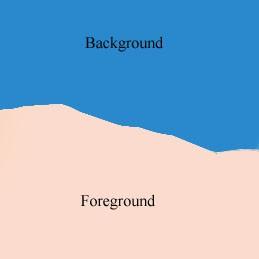
2 Sky Forest Wasteland Classify land use pattern Settlements Vegetation Foreground, Background separation Mineral Identification Heavy minerals
3 OBJECTIVE To select a statistical and texture features from the IRS1D- Liss III imagery From ground truth information, collect the training samples Classify Satellite imageries with various Supervised, Unsupervised techniques and determine the best classification method. Extract the information landforms and Settlements. from classified Coastal

4 STUDY AREA
5 LOCATION The present study area between Kallar and Vembar lies in Tamilnadu with in the latitudes of 8 55 to 9 5 N and longitudes of to E. The stretch extents over a length of about 24km. It is bounded by Gulf of Mannar in the east, Surangudi in the west, Vembar river in the north and Kallar river in the south. This area is enriched with various placer mineral deposits

6 Geomorphology map of Southern Tamilnadu

7 Geomorphology map of Vembar-Kallar
8 CLASSIFICATION Classification is the act of assigning a class label to an object, a physical process or an event. Class assignment based on measurements that are obtained from that object. Measurements are values of some attributes (features) of the object, e.g. shape, length, texture, color etc.
9 PROCEDURE FOR CLASSIFICATION Preprocessing Segmentation Feature extraction Training samples Classification Post-Classification
10 Preprocessing Segmentation Feature extraction Training samples Classification Post-Classification
11 PRE-PROCESSING To simplify subsequent operations without loosing relevant information. Image Details: IRS-1D-LISS III, 1:25000 scale (June 2002), Coastal area between Kallar and Vembar Original Image Preprocessed Image
12 Preprocessing Segmentation Feature extraction Training samples Classification Post-Classification
13 IMAGE SEGMENTATION A common definition for segmentation is Partitioning a digital image into multiple segments in order to find the objects within the image. Segmentation can recognize homogeneous regions within an image as distinct and belonging to different objects. Segmentation is used to identify the object or measurement of various targets in an satellite image. Major application areas are geological exploration, remote sensing, robot navigation, medical image analysis, and military applications. This presentation focused two types of segmentation application 1. Object identification (Feature selection) 2. Post classification (Class separation)
14 Object identification Segmentation is used to digitally identify and classify pixels in the data. K-means algorithm is a cluster based technique used here for segmentation. K-means algorithm K-means is a unsupervised algorithm used here for image segmentation. This algorithm is composed three steps: 1. Place K points into the space represented by the objects that are being clustered. 2. Assign each object to the group that has the closest centroid. When all objects have been assigned, recalculate the positions of the K centroids. 3. Repeat above until the centroids no longer move.

15 K-MEANS SEGMENTATION RESULTS Pre-processed Image K-means Segmentation
16 Preprocessing Segmentation Feature extraction Training samples Classification Post-Classification
17 FEATURE EXTRACTION Features are patterns or unique structures which is extracted from the object. The number of features is generally chosen to be fewer than the total necessary to describe the complete target of interest. Feature selection Process 1. Spatial features a) Ground truth ROI s 2. Statistical features a) Data range b) Entropy c) Mean d) Skewness e) Variance 3. Texture features a) Homogeneity b) Dissimilarity c) Correlation d) Contrast e) Secondmoment


18 STATISTICAL AND TEXTURE FEATURES Band 1 Data range Entropy Variance Mean Skewness Variance Contrast Homogeneity Dissimilarity Second moment Contrast Homogeneity Dissimilarity Second moment Variance Contrast Homogeneity Dissimilarity Band 2 Data range Entropy Variance Mean Skewness Variance Band 3 Data range Entropy Variance Mean Skewness Second moment
19 Preprocessing Segmentation Feature extraction Training samples Classification Post-Classification
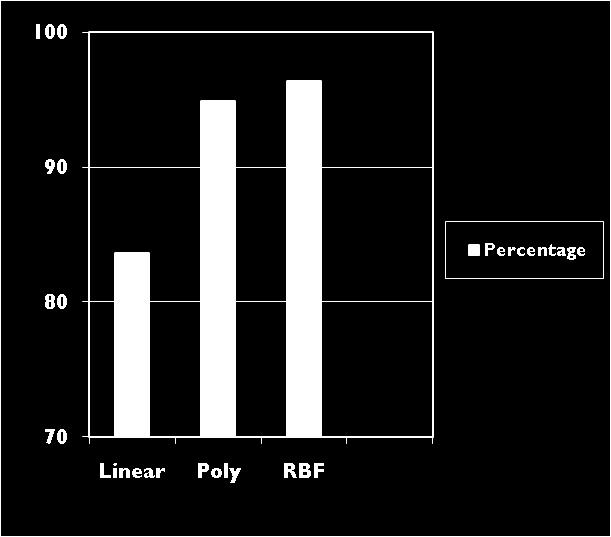
20 TRAINING SAMPLES A set of samples usually called as Training set. The samples are provided with a label carrying the information of the true class of the corresponding object. The density can be estimated from the samples by kernel methods. Here, three kernel methods considered for further analysis. Linear Polynomial Radial Basis Function Cross validation accuracy used here to check the performance of Training samples.


21 TRAINING RESULT Ground truth ROI ROI+ ST parameters
22 Preprocessing Segmentation Feature extraction Training samples Classification Post-Classification
23 CLASSIFICATION METHODS AND TECHNIQUES Two types of classification methods: Supervised Classification Unsupervised Classification Supervised Classification Parallelepiped Minimum Distance Mahalanobis Distance Maximum likelihood Binary encoding Support vector machine Unsupervised Classification 1. IsoData 2. K-means


24 SUPERVISED CLASSIFICATION RESULTS Minimum distance Parallelepiped 4 bands ST features 4 bands Maximum likelihood 4 bands ST features ST features Binary encoding 4 bands ST features


25 Mahalanobis distance 4 bands ST features Support Vector Machine 4 bands ST features UNSUPERVISED CLASSIFICATION RESULTS IsoData (Accuracy: K-means (Accuracy: %)
26 OVERALL ACCURACY (4 bands) Kappa Co-efficient Parelleped (PP) Minimum Distance (MinD) Maximum Likelihood (MaxL) Binary encoding (Bin) Mahalonobis (Mah) Support Vector Machine (SVM)
 Binary encoding (Bin) Mahalonobis (Mah) Support Vector Machine (SVM) 0.4308 0.6269 0.9178 0.2645 0.7045 0.")
27 OVERALL RESULTS (ST features) Kappa Co-efficient Parelleped (PP) Minimum Distance (MinD) Maximum Likelihood (MaxL) Binary encoding (Bin) Mahalonobis (Mah) Support Vector Machine (SVM)
28 Preprocessing Segmentation Feature extraction Training samples Classification Post-Classification
29 POST CLASSIFICATION Post Classification enclosed following processes: 1. Class statistics 2. Clump classes 3. Sieve classes 4. Combine classes 5. Overlay Classes 6. Class segmentation 7. Buffer zone 8. Vectorization Thresholding Segmentation Comparing each pixel based on Threshold value in order to separate the class. Each class contain common attribute values. Class separation has to be done by assigning threshold value.


30 CLASS SEGMENTATION RESULTS Classified image Saltpan Creeks Land with scrub Land settlements Mangrove Mud with mangroves River Agriculture Beach ridges Tank Gulf of mannar
31 DISCUSSION From the classification result it is found that Support Vector machine performed well. SVM based classified image considered for Coastal land form studies. Our study area is characterized by a variety of complex environments like beaches, saltpans, river, tanks, dunes and marshes, mangroves, settlements etc. Saltpan From the classified image, extensive area is covered of salt pan near Veppalodai, for about 10.1Km². The dry salt pan appears to be bright white tone.
32 DISCUSSION Tanks and Swales The prominent swale system is found in the coastal plain between Periasamypuram to Vembar river mouth. The swale is almost parallel to the coastline; their width is about 1.5Km. Creek Beach is characterized by numerous creeks. These creeks are responsible for water logging of vast area throughout the year. Mudflat The mudflat areas are seen near Kallar, Tulukankulam, Vaippar and Vembar.
33 DISCUSSION Mangroves and Vegetation From the classified image, Mangrove varieties like Suaeda Monoinca, Suaeda Maritime and Salicornia brachiata are commonly found along the study area. Beach ridges Beach ridges between Kulathur and Vaippar river has covered by Teri sands and plantation vegetation. Beach ridges between Melmandai and east of Surankudi has dune materials like sand gravel and shingle. Rivers the most important river is Vaippar and it is seen in the classified image.
34 R&D Activities in Centre for GeoTechnology Remote sensing and GIS applications on Beach placer minerals evaluation along the coast between Kallar and Vembar - DOD Project. Exploration of Beach placer in Kallar and Vaippar DOD Project. Impact of beach placer mining along the coast of Tamilnadu DST Project. Corel reef monitoring through Remote sensing and GIS in Gulf of Mannar - NATP, ICAR Project. An operation as Marine GIS Expert system for non living resource mapping DST Project.
35 Thank you
Abstract: About the Author:
 REMOTE SENSING AND GIS IN LAND USE PLANNING Sathees kumar P 1, Nisha Radhakrishnan 2 1 1 Ph.D Research Scholar, Department of Civil Engineering, National Institute of Technology, Tiruchirappalli- 620015,
Outline Introduction Objectives Study Area Methodology Result Discussion Conclusion
 Land Cover, Land Use of two bioluminescent bays in Puerto Rico Undergraduate Research By: Yadira Soto Viruet Advisor: Fernando Gilbes Santaella, Ph.D Outline Introduction Objectives Study Area Methodology
7.1 INTRODUCTION 7.2 OBJECTIVE
 7 LAND USE AND LAND COVER 7.1 INTRODUCTION The knowledge of land use and land cover is important for many planning and management activities as it is considered as an essential element for modeling and
1. Introduction. S.S. Patil 1, Sachidananda 1, U.B. Angadi 2, and D.K. Prabhuraj 3
 Cloud Publications International Journal of Advanced Remote Sensing and GIS 2014, Volume 3, Issue 1, pp. 525-531, Article ID Tech-249 ISSN 2320-0243 Research Article Open Access Machine Learning Technique
Environmental Impact Assessment Land Use and Land Cover CISMHE 7.1 INTRODUCTION
 7 LAND USE AND LAND COVER 7.1 INTRODUCTION The knowledge of land use and land cover is important for many planning and management activities as it is considered an essential element for modeling and understanding
Principals and Elements of Image Interpretation
 Principals and Elements of Image Interpretation 1 Fundamentals of Photographic Interpretation Observation and inference depend on interpreter s training, experience, bias, natural visual and analytical
Preparation of LULC map from GE images for GIS based Urban Hydrological Modeling
 International Conference on Modeling Tools for Sustainable Water Resources Management Department of Civil Engineering, Indian Institute of Technology Hyderabad: 28-29 December 2014 Abstract Preparation
Fundamentals of Photographic Interpretation
 Principals and Elements of Image Interpretation Fundamentals of Photographic Interpretation Observation and inference depend on interpreter s training, experience, bias, natural visual and analytical abilities.
Ecological mapping using satellite imagery: an Abu Dhabi case study Middle East Geospatial Forum 16 th February 2015
 Ecological mapping using satellite imagery: an Abu Dhabi case study Middle East Geospatial Forum 16 th February 2015 Richard Flemmings rf@proteusgeo.com About Proteus Formed in UAE 2011 We specialise in
IMPROVING REMOTE SENSING-DERIVED LAND USE/LAND COVER CLASSIFICATION WITH THE AID OF SPATIAL INFORMATION
 IMPROVING REMOTE SENSING-DERIVED LAND USE/LAND COVER CLASSIFICATION WITH THE AID OF SPATIAL INFORMATION Yingchun Zhou1, Sunil Narumalani1, Dennis E. Jelinski2 Department of Geography, University of Nebraska,
SATELLITE REMOTE SENSING
 SATELLITE REMOTE SENSING of NATURAL RESOURCES David L. Verbyla LEWIS PUBLISHERS Boca Raton New York London Tokyo Contents CHAPTER 1. SATELLITE IMAGES 1 Raster Image Data 2 Remote Sensing Detectors 2 Analog
INTERNATIONAL JOURNAL OF GEOMATICS AND GEOSCIENCES Volume 6, No 2, 2015
 INTERNATIONAL JOURNAL OF GEOMATICS AND GEOSCIENCES Volume 6, No 2, 2015 Copyright by the authors - Licensee IPA- Under Creative Commons license 3.0 Research article ISSN 0976 4380 An Analysis of Land use
Comparative Analysis of Supervised and
 Applied Mathematical Sciences, Vol.,, no., 68-69 HIKARI Ltd, www.m-hikari.com http://dx.doi.org/.988/ams.. Comparative Analysis of Supervised and Unsupervised Classification on Multispectral Data Asmala
ASSESSMENT OF TSUNAMI DAMAGE TO MANGROVE IN INDIA USING REMOTE SENSING AND GIS
 ASSESSMENT OF TSUNAMI DAMAGE TO MANGROVE IN INDIA USING REMOTE SENSING AND GIS B. Chatterjee 1 M.C.Porwal 1 Y. A. Hussin 2 (1) Indian Institute of Remote Sensing, 4, Kalidas Road, Dehradun - 248 001 (India)
ART Based Reliable Method for Prediction of Agricultural Land Changes Using Remote Sensing
 Circuits and Systems, 2016, 7, 1051-1067 Published Online May 2016 in SciRes. http://www.scirp.org/journal/cs http://dx.doi.org/10.4236/cs.2016.76089 ART Based Reliable Method for Prediction of Agricultural
LAND SUITABILITY STUDY IN LAND DEGRADED AREA DUE TO MINING IN DHANBAD DISTRICT, JHARKHAND.
 LAND SUITABILITY STUDY IN LAND DEGRADED AREA DUE TO MINING IN DHANBAD DISTRICT, JHARKHAND. Saranathan, E a*, Loveson, V.J b. and Victor Rajamanickam, G c a School of Civil Engineering, SASTRA, Thanjavur
Classification of High Spatial Resolution Remote Sensing Images Based on Decision Fusion
 Journal of Advances in Information Technology Vol. 8, No. 1, February 2017 Classification of High Spatial Resolution Remote Sensing Images Based on Decision Fusion Guizhou Wang Institute of Remote Sensing
Object-based feature extraction of Google Earth Imagery for mapping termite mounds in Bahia, Brazil
 OPEN ACCESS Conference Proceedings Paper Sensors and Applications www.mdpi.com/journal/sensors Object-based feature extraction of Google Earth Imagery for mapping termite mounds in Bahia, Brazil Sunhui
LAND USE AND LAND COVER CHANGE DETECTION USING REMOTE SENSING AND GIS FROM THOOTHUKUDI TO VEMBAR COAST
 LAND USE AND LAND COVER CHANGE DETECTION USING REMOTE SENSING AND GIS FROM THOOTHUKUDI TO VEMBAR COAST R.A.Rejin Nishkalank 1,B.Gurugnanam 2 1,2 Centre for Applied Geology, Gandhigram Rural Institute Deemed
International Journal of Scientific & Engineering Research, Volume 6, Issue 7, July ISSN
 International Journal of Scientific & Engineering Research, Volume 6, Issue 7, July-2015 1428 Accuracy Assessment of Land Cover /Land Use Mapping Using Medium Resolution Satellite Imagery Paliwal M.C &.
This is trial version
 Journal of Rangeland Science, 2012, Vol. 2, No. 2 J. Barkhordari and T. Vardanian/ 459 Contents available at ISC and SID Journal homepage: www.rangeland.ir Full Paper Article: Using Post-Classification
COASTAL QUATERNARY GEOLOGY MAPPING FOR NSW: EXAMPLES AND APPLICATIONS
 COASTAL QUATERNARY GEOLOGY MAPPING FOR NSW: EXAMPLES AND APPLICATIONS A Troedson Geological Survey of New South Wales Abstract Detailed geological mapping of the coastal plains of regional NSW was undertaken
Deriving Uncertainty of Area Estimates from Satellite Imagery using Fuzzy Land-cover Classification
 International Journal of Information and Computation Technology. ISSN 0974-2239 Volume 3, Number 10 (2013), pp. 1059-1066 International Research Publications House http://www. irphouse.com /ijict.htm Deriving
Abstract. TECHNOFAME- A Journal of Multidisciplinary Advance Research. Vol.2 No. 2, (2013) Received: Feb.2013; Accepted Oct.
 Received: Feb.2013; Accepted Oct.") Vol.2 No. 2, 83-87 (2013) Received: Feb.2013; Accepted Oct. 2013 Landuse Pattern Analysis Using Remote Sensing: A Case Study of Morar Block, of Gwalior District, M.P. Subhash Thakur 1 Akhilesh Singh 2
Vol.2 No. 2, 83-87 (2013) Received: Feb.2013; Accepted Oct. 2013 Landuse Pattern Analysis Using Remote Sensing: A Case Study of Morar Block, of Gwalior District, M.P. Subhash Thakur 1 Akhilesh Singh 2
Submitted to: Central Coalfields Limited Ranchi, Jharkhand. Ashoka & Piparwar OCPs, CCL
 Land Restoration / Reclamation Monitoring of more than 5 million cu. m. (Coal + OB) Capacity Open Cast Coal Mines of Central Coalfields Limited Based on Satellite Data for the Year 2013 Ashoka & Piparwar
HEAVY MINERALS INVESTIGATION USING GEOSPATIAL TECHNOLOGY
 HEAVY MINERALS INVESTIGATION USING GEOSPATIAL TECHNOLOGY *Muthiah.M.S, **Colins Johnny.J, *PG student: Department of Civil Engineering, Anna University Regional Campus Tirunelveli, India **Assistant Professor:
Comparison of MLC and FCM Techniques with Satellite Imagery in A Part of Narmada River Basin of Madhya Pradesh, India
 Cloud Publications International Journal of Advanced Remote Sensing and GIS 013, Volume, Issue 1, pp. 130-137, Article ID Tech-96 ISS 30-043 Research Article Open Access Comparison of MLC and FCM Techniques
Habitat Mapping using Remote Sensing for Green Infrastructure Planning in Anguilla
 Habitat Mapping using Remote Sensing for Green Infrastructure Planning in Anguilla Dr Katie Medcalf Cenv MIEEM www.envsys.co.uk Context Introduction to Anguilla Habitat mapping using Earth Observation
INTRODUCTION ABSTRACT
 Health Assessment Modelling of Pichavaram Mangroves by the Application of Remote Sensing and GIS A Tool for Evolving Climate Change Adaptation Strategies ABSTRACT Kannan T. M.E. Geomatics, Institute of
Detection of Land Use and Land Cover Change around Eti-Osa Coastal Zone, Lagos State, Nigeria using Remote Sensing and GIS
 International Research Journal of Environment Sciences E-ISSN 2319 1414 Detection of Land Use and Land Cover Change around Eti-Osa Coastal Zone, Lagos State, Nigeria using Remote Sensing and GIS Abstract
A COMPARISON BETWEEN DIFFERENT PIXEL-BASED CLASSIFICATION METHODS OVER URBAN AREA USING VERY HIGH RESOLUTION DATA INTRODUCTION
 A COMPARISON BETWEEN DIFFERENT PIXEL-BASED CLASSIFICATION METHODS OVER URBAN AREA USING VERY HIGH RESOLUTION DATA Ebrahim Taherzadeh a, Helmi Z.M. Shafri a, Seyed Hassan Khalifeh Soltani b, Shattri Mansor
LAND COVER CATEGORY DEFINITION BY IMAGE INVARIANTS FOR AUTOMATED CLASSIFICATION
 LAND COVER CATEGORY DEFINITION BY IMAGE INVARIANTS FOR AUTOMATED CLASSIFICATION Nguyen Dinh Duong Environmental Remote Sensing Laboratory Institute of Geography Hoang Quoc Viet Rd., Cau Giay, Hanoi, Vietnam
Satellite Based Seismic Technology
 Satellite Based Seismic Technology Dr. V.K. Srivastava, R. Ghosh*, B.B Chhualsingh Department of Applied Geophysics, Indian School of mines, Dhanbad. E- mail: ismkvinay@hotmail.com, ghosh.ramesh@rediffmail.com,
SIF_7.1_v2. Indicator. Measurement. What should the measurement tell us?
 Indicator 7 Area of natural and semi-natural habitat Measurement 7.1 Area of natural and semi-natural habitat What should the measurement tell us? Natural habitats are considered the land and water areas
79 International Journal of Scientific & Engineering Research, Volume 4, Issue 12, December-2013 ISSN
 79 International Journal of Scientific & Engineering Research, Volume 4, Issue 12, December-2013 Approach to Assessment tor RS Image Classification Techniques Pravada S. Bharatkar1 and Rahila Patel1 ABSTRACT
Change Detection of Daghesorkh Playa Using Multi Temporal Datasets (Isfahan Province, Iran)
") J. Appl. Environ. Biol. Sci., 6(1)23-3, 216 216, TextRoad Publication ISSN: 29-4274 Journal of Applied Environmental and Biological Sciences www.textroad.com Change Detection of Daghesorkh Playa Using
J. Appl. Environ. Biol. Sci., 6(1)23-3, 216 216, TextRoad Publication ISSN: 29-4274 Journal of Applied Environmental and Biological Sciences www.textroad.com Change Detection of Daghesorkh Playa Using
M.C.PALIWAL. Department of Civil Engineering NATIONAL INSTITUTE OF TECHNICAL TEACHERS TRAINING & RESEARCH, BHOPAL (M.P.), INDIA
, INDIA") INVESTIGATIONS ON THE ACCURACY ASPECTS IN THE LAND USE/LAND COVER MAPPING USING REMOTE SENSING SATELLITE IMAGERY By M.C.PALIWAL Department of Civil Engineering NATIONAL INSTITUTE OF TECHNICAL TEACHERS
INVESTIGATIONS ON THE ACCURACY ASPECTS IN THE LAND USE/LAND COVER MAPPING USING REMOTE SENSING SATELLITE IMAGERY By M.C.PALIWAL Department of Civil Engineering NATIONAL INSTITUTE OF TECHNICAL TEACHERS
Monitoring of Forest Cover Change in Sundarban mangrove forest using Remote sensing and GIS
 Monitoring of Forest Cover Change in Sundarban mangrove forest using Remote sensing and GIS By Mohammed Monirul Alam April 2008 Content 1: INTRODUCTION 2: OBJECTIVES 3: METHODOLOGY 4: RESULTS & DISCUSSION
Coastline monitoring. Virginie Lafon Cyril Mallet. S. Capo, A. Dehouck, E. Maneux, A. Michot, C. Proisy, R. Walker
 Coastline monitoring Virginie Lafon Cyril Mallet Doris_Net May 29, 2012 Pessac, France S. Capo, A. Dehouck, E. Maneux, A. Michot, C. Proisy, R. Walker 29/05/2012 Spatial applications for coastal services
Remote sensing approach to identify salt-affected soils in Hambantota District
 PROCEEDINGS OF THE SECOND ACADEMIC SESSIONS - 2004 Remote sensing approach to identify salt-affected soils in Hambantota District PG Chandana', K.D.N. Weerasinghe', S. Subasinghe' and S. Pathirana" 'Department
Wastelands Analysis and Mapping of Bhiwani District, Haryana
 Wastelands Analysis and Mapping of Bhiwani District, Haryana Virender Sihag Research Scholar, Department of Geography, OPJS University, Churu, Rajasthan ABSTRACT This study aimed at monitoring, mapping,
A Baseline Mapping of Aquaculture and Coastal Habitats in Myanmar
 Aquaculture and Coastal Habitats Report No. 3 A Baseline Mapping of Aquaculture and Coastal Habitats in Myanmar J. Ronald Eastman, James Toledano, Stefano Crema Clark Labs, Clark University Introduction
Survey of Land Use and Land Cover Change Detection using Remote Sensing
 Survey of Land Use and Land Cover Change Detection using Remote Sensing S.V.Hwan, Dr. Eun-Kyung JO Research Scholar, Professor, Dept. of geosciences, Institute of Geology / Estonian Academy of Science,
Coalfields Limited. Based on Satellite Data for the Year Central Coalfields Limited Ranchi, Jharkhand. Submitted to:
 Land Restoration / Reclamation Monitoring of less than 5 m cu. m. (Coal + OB) Capacity Open Cast Coal Mines of Central Coalfields Limited Based on Satellite Data for the Year 2011. N URIMARI (BIRSA) OCP,CCL
A Method to Improve the Accuracy of Remote Sensing Data Classification by Exploiting the Multi-Scale Properties in the Scene
 Proceedings of the 8th International Symposium on Spatial Accuracy Assessment in Natural Resources and Environmental Sciences Shanghai, P. R. China, June 25-27, 2008, pp. 183-188 A Method to Improve the
Submitted to Central Coalfields Limited BHURKUNDA OCP, CCL
 Land Restoration / Reclamation Monitoring of Open Cast Coal Mines of Central Coalfields Limited producing less than 5 m cu m. (Coal+ OB) based on Satellite Data for the Year 2013 BHURKUNDA OCP, CCL Submitted
Change Detection Across Geographical System of Land using High Resolution Satellite Imagery
 IJCTA, 9(40), 2016, pp. 129-139 International Science Press Closed Loop Control of Soft Switched Forward Converter Using Intelligent Controller 129 Change Detection Across Geographical System of using
GEOG 4110/5100 Advanced Remote Sensing Lecture 12. Classification (Supervised and Unsupervised) Richards: 6.1, ,
 Richards: 6.1, ,") GEOG 4110/5100 Advanced Remote Sensing Lecture 12 Classification (Supervised and Unsupervised) Richards: 6.1, 8.1-8.8.2, 9.1-9.34 GEOG 4110/5100 1 Fourier Transforms Transformations in the Frequency Domain
GEOG 4110/5100 Advanced Remote Sensing Lecture 12 Classification (Supervised and Unsupervised) Richards: 6.1, 8.1-8.8.2, 9.1-9.34 GEOG 4110/5100 1 Fourier Transforms Transformations in the Frequency Domain
The Positional and Thematic Accuracy for Analysis of Multi-Temporal Satellite Images on Mangrove Areas
 The Positional and Thematic Accuracy for Analysis of Multi-Temporal Satellite Images on Mangrove Areas Paulo Rodrigo Zanin¹, Carlos Antonio O. Vieira² ¹Universidade Federal de Santa Catarina, Campus Universitário
The Systems Approach. Alun Williams, ABPmer
 The Systems Approach Alun Williams, ABPmer Overview What is A Systems Approach? Behavioural / Qualitative Modelling? System Definition / Mapping (Behavioural Statements Objective) What is a Systems Approach?
Effect of land use/land cover changes on runoff in a river basin: a case study
 Water Resources Management VI 139 Effect of land use/land cover changes on runoff in a river basin: a case study J. Letha, B. Thulasidharan Nair & B. Amruth Chand College of Engineering, Trivandrum, Kerala,
LAND USE LAND COVER, CHANGE DETECTION OF FOREST IN KARWAR TALUK USING GEO-SPATIAL TECHNIQUES
 LAND USE LAND COVER, CHANGE DETECTION OF FOREST IN KARWAR TALUK USING GEO-SPATIAL TECHNIQUES Dr. A.G Koppad 1, Malini P.J 2 Professor and University Head (NRM) COF SIRSI, UAS DHARWAD Research Associate,
Accuracy Assessment of Land Cover Classification in Jodhpur City Using Remote Sensing and GIS
 Accuracy Assessment of Land Cover Classification in Jodhpur City Using Remote Sensing and GIS S.L. Borana 1, S.K.Yadav 1 Scientist, RSG, DL, Jodhpur, Rajasthan, India 1 Abstract: A This study examines
Characterization of the Nigerian Shoreline using Publicly-Available Satellite Imagery
 University of New Hampshire University of New Hampshire Scholars' Repository Center for Coastal and Ocean Mapping Center for Coastal and Ocean Mapping 1-2014 Characterization of the Nigerian Shoreline
2 Georgia: Its Heritage and Its Promise
 TERMS region, erosion, fault, elevation, Fall Line, aquifer, marsh, climate, weather, precipitation, drought, tornado, hurricane, wetland, estuary, barrier island, swamp PLACES Appalachian Mountains, Appalachian
Land cover classification methods. Ned Horning
 Land cover classification methods Ned Horning Version: 1.0 Creation Date: 2004-01-01 Revision Date: 2004-01-01 License: This document is licensed under a Creative Commons Attribution-Share Alike 3.0 Unported
Identification of Land use and Land cover Changes using Remote Sensing and GIS
 Identification of Land use and Land cover Changes using Remote Sensing and GIS N. Nagarajan and. S. Poongothai Abstract This study reveals to identify the changes of land use/land cover of rural agricultural
CHAPTER 1. Geo Challenges 1A to 1D. & World Map Activity
 CHAPTER 1 Geo Challenges 1A to 1D & World Map Activity SELECT YOUR CHALLENGE World Map Activity Challenge 1A Challenge 1B Challenge 1C Challenge 1D Challenge 1A WS PG. 2 STEP #1 Label the largest continent
Combination of Microwave and Optical Remote Sensing in Land Cover Mapping
 Combination of Microwave and Optical Remote Sensing in Land Cover Mapping Key words: microwave and optical remote sensing; land cover; mapping. SUMMARY Land cover map mapping of various types use conventional
The Self-adaptive Adjustment Method of Clustering Center in Multi-spectral Remote Sensing Image Classification of Land Use
 The Self-adaptive Adjustment Method of Clustering Center in Multi-spectral Remote Sensing Image Classification of Land Use Shujing Wan 1,Chengming Zhang(*) 1,2, Jiping Liu 2, Yong Wang 2, Hui Tian 1, Yong
Dr. S.SURIYA. Assistant professor. Department of Civil Engineering. B. S. Abdur Rahman University. Chennai
 Hydrograph simulation for a rural watershed using SCS curve number and Geographic Information System Dr. S.SURIYA Assistant professor Department of Civil Engineering B. S. Abdur Rahman University Chennai
Aim and objectives Components of vulnerability National Coastal Vulnerability Assessment 2
 ASSESSING THE UTILITY OF GEOMORPHIC SENSITIVITY MAPPING ON THE ILLAWARRA COAST Pamela Abuodha, Christina Baker, Chris Sharples, Darren Skene and Colin Woodroffe Geoquest Research Centre, University of
APPLICATION OF REMOTE SENSING IN LAND USE CHANGE PATTERN IN DA NANG CITY, VIETNAM
 APPLICATION OF REMOTE SENSING IN LAND USE CHANGE PATTERN IN DA NANG CITY, VIETNAM Tran Thi An 1 and Vu Anh Tuan 2 1 Department of Geography - Danang University of Education 41 Le Duan, Danang, Vietnam
FLOOD ANALYSIS USING SATELLITE DATA AND GEOMORPHOLOGICAL SURVEY MAP SHOWING CLASSIFICATION OF FLOOD-INUNDATED AREAS
 FLOOD ANALYSIS USING SATELLITE DATA AND GEOMORPHOLOGICAL SURVEY MAP SHOWING CLASSIFICATION OF FLOOD-INUNDATED AREAS Yasuharu YAMADA* *Japan International Research Center for Agricultural Sciences (JIRCAS),
Name period date assigned date due date returned. Texas Ecoregions
 Name period date assigned date due date returned Directions: Go to the following website: https://www-k6.thinkcentral.com/epc/start.do Use the log in that is taped to the top of your laptop. If you are
Urban Sprawl Mapping and Landuse Change Detection in and around Udupi Town: A Remote Sensing based Approach
 Urban Sprawl Mapping and Landuse Change Detection in and around Udupi Town: A Remote Sensing based Approach 1 K. Silambarasan, 2 M. S. Vinaya, 3 S. Suresh Babu 1,2,3 Department of Civil Engineering, 1,2,3
Name period date assigned date due date returned. Texas Ecoregions
 Name period date assigned date due date returned Directions: Go to the following website: https://www-k6.thinkcentral.com/epc/start.do Use the log in that is taped to the top of your laptop. If you are
Table 4.1 Images used for the Study. Spatial Resolution (Meter) Resolution (Bits) 30 (For 6th band 120)
 Resolution (Bits) 30 (For 6th band 120)")
Object-Oriented Oriented Method to Classify the Land Use and Land Cover in San Antonio using ecognition Object-Oriented Oriented Image Analysis
 Object-Oriented Oriented Method to Classify the Land Use and Land Cover in San Antonio using ecognition Object-Oriented Oriented Image Analysis Jayar S. Griffith ES6973 Remote Sensing Image Processing
1 Shoreline Landforms 2. 2 Emergent v. Submergent 2. 3 Wavecutting 3. 4 Planview 4. 5 Marine Terraces 5. 6 California 7. 7 Tombolos, Sea Stacks 8
 Shorelines November 9, 2008 Contents 1 Shoreline Landforms 2 2 Emergent v. Submergent 2 3 Wavecutting 3 4 Planview 4 5 Marine Terraces 5 6 California 7 7 Tombolos, Sea Stacks 8 8 Active Processes 9 9 Emergence
Land cover classification methods
 Land cover classification methods This document provides an overview of land cover classification using remotely sensed data. We will describe different options for conducting land cover classification
Sri Lanka has a coastline of km excluding the shoreline of bays and inlets.
 Defining and Demarcating Coastal zones in Sri Lanka Procedure, Challenges and What needs to be done? Dr. Anil Premaratne Director General Coast Conservation Coast Conservation Department Sri Lanka 1 Sri
Land Use and Land Cover Detection by Different Classification Systems using Remotely Sensed Data of Kuala Tiga, Tanah Merah Kelantan, Malaysia
 Land Use and Land Cover Detection by Different Classification Systems using Remotely Sensed Data of Kuala Tiga, Tanah Merah Kelantan, Malaysia Wani Sofia Udin*, Zuhaira Nadhila Zahuri Faculty of Earth
Map Introduction: South Uist Map 1
 96 Map Introduction: Map This map section covers part of the south coast of, including the head of the causeway which links the island to Eriskay. It extends from South Glen Dale to Taobh a'caolas. There
The Application of Extreme Learning Machine based on Gaussian Kernel in Image Classification
 he Application of Extreme Learning Machine based on Gaussian Kernel in Image Classification Weijie LI, Yi LIN Postgraduate student in College of Survey and Geo-Informatics, tongji university Email: 1633289@tongji.edu.cn
AN INVESTIGATION OF AUTOMATIC CHANGE DETECTION FOR TOPOGRAPHIC MAP UPDATING
 AN INVESTIGATION OF AUTOMATIC CHANGE DETECTION FOR TOPOGRAPHIC MAP UPDATING Patricia Duncan 1 & Julian Smit 2 1 The Chief Directorate: National Geospatial Information, Department of Rural Development and
DETECTING HUMAN ACTIVITIES IN THE ARCTIC OCEAN BY CONSTRUCTING AND ANALYZING SUPER-RESOLUTION IMAGES FROM MODIS DATA INTRODUCTION
 DETECTING HUMAN ACTIVITIES IN THE ARCTIC OCEAN BY CONSTRUCTING AND ANALYZING SUPER-RESOLUTION IMAGES FROM MODIS DATA Shizhi Chen and YingLi Tian Department of Electrical Engineering The City College of
Chemometrics: Classification of spectra
 Chemometrics: Classification of spectra Vladimir Bochko Jarmo Alander University of Vaasa November 1, 2010 Vladimir Bochko Chemometrics: Classification 1/36 Contents Terminology Introduction Big picture
CHANGES IN VIJAYAWADA CITY BY REMOTE SENSING AND GIS
 International Journal of Civil Engineering and Technology (IJCIET) Volume 8, Issue 5, May 2017, pp.217 223, Article ID: IJCIET_08_05_025 Available online at http://www.ia aeme.com/ijciet/issues.asp?jtype=ijciet&vtyp
Object Based Land Cover Extraction Using Open Source Software
 Object Based Land Cover Extraction Using Open Source Software Abhasha Joshi 1, Janak Raj Joshi 2, Nawaraj Shrestha 3, Saroj Sreshtha 4, Sudarshan Gautam 5 1 Instructor, Land Management Training Center,
High resolution wetland mapping I.
 High resolution wetland mapping I. Based on the teaching material developed by Steve Kas, GeoVille for WOIS Product Group #5 Dr. Zoltán Vekerdy and János Grósz z.vekerdy@utwente.nl vekerdy.zoltan@mkk.szie.hu
Yaneev Golombek, GISP. Merrick/McLaughlin. ESRI International User. July 9, Engineering Architecture Design-Build Surveying GeoSpatial Solutions
 Yaneev Golombek, GISP GIS July Presentation 9, 2013 for Merrick/McLaughlin Conference Water ESRI International User July 9, 2013 Engineering Architecture Design-Build Surveying GeoSpatial Solutions Purpose
Journal of Telecommunications System & Management
 njournal of Telecommunicatio s System & Management Journal of Telecommunications System & Management Kota et al., J Telecommun Syst Manage 2017, 6:1 DOI: 10.4172/2167-0919.1000148 Research Article OMICS
MULTI-SOURCE IMAGE CLASSIFICATION
 MULTI-SOURCE IMAGE CLASSIFICATION Hillary Tribby, James Kroll, Daniel Unger, I-Kuai Hung, Hans Williams Corresponding Author: Daniel Unger (unger@sfasu.edu Arthur Temple College of Forestry and Agriculture
INTERNATIONAL JOURNAL OF GEOMATICS AND GEOSCIENCES Volume 3, No 3, 2013
 INTERNATIONAL JOURNAL OF GEOMATICS AND GEOSCIENCES Volume 3, No 3, 2013 Copyright by the authors - Licensee IPA- Under Creative Commons license 3.0 Research article ISSN 0976 4380 Role of Remote Sensing
International Journal of Scientific Research and Reviews
 Case Study Available online www.ijsrr.org ISSN: 2279 0543 International Journal of Scientific Research and Reviews Study on the Pattern of Land Use /Land Cover Change in Sonipat District of NCR, A Block
INTERNATIONAL JOURNAL OF GEOMATICS AND GEOSCIENCES Volume 1, No 1, 2010
 An Integrated Approach with GIS and Remote Sensing Technique for Landslide Hazard Zonation S.Evany Nithya 1 P. Rajesh Prasanna 2 1. Lecturer, 2. Assistant Professor Department of Civil Engineering, Anna
Temporal and spatial approaches for land cover classification.
 Temporal and spatial approaches for land cover classification. Ryabukhin Sergey sergeyryabukhin@gmail.com Abstract. This paper describes solution for Time Series Land Cover Classification Challenge (TiSeLaC).
Module 2.1 Monitoring activity data for forests using remote sensing
 Module 2.1 Monitoring activity data for forests using remote sensing Module developers: Frédéric Achard, European Commission (EC) Joint Research Centre (JRC) Jukka Miettinen, EC JRC Brice Mora, Wageningen
LANDSCAPE PATTERN AND PER-PIXEL CLASSIFICATION PROBABILITIES. Scott W. Mitchell,
 LANDSCAPE PATTERN AND PER-PIXEL CLASSIFICATION PROBABILITIES Scott W. Mitchell, Department of Geography and Environmental Studies, Carleton University, Loeb Building B349, 1125 Colonel By Drive, Ottawa,
Developing fragility functions for tsunami damage estimation using the numerical model and satellite imagery
 Developing fragility functions for tsunami damage estimation using the numerical model and satellite imagery Shunichi KOSHIMURA 1 and Hideaki YANAGISAWA 2 1 Associate Professor, Disaster Control Research
Holocene evolution of Dahab coastline Gulf of Aqaba, Sinai Peninsula, Egypt 1
 Holocene evolution of Dahab coastline Gulf of Aqaba, Sinai Peninsula, Egypt 1 Magdy Torab* 2 * Prof. of Geomorphology, Department of Geography, Damanhour University, Egypt 3 E-mail: magdytorab@hotmail.com.
Guided Reading Activity
 Guided Reading Activity Lesson 1 Physical Features Essential Question: How does geography influence the way people live? A Vast Land Directions: Read the lesson and use your text to decide whether each
Land Cover Classification Over Penang Island, Malaysia Using SPOT Data
 Land Cover Classification Over Penang Island, Malaysia Using SPOT Data School of Physics, Universiti Sains Malaysia, 11800 Penang, Malaysia. Tel: +604-6533663, Fax: +604-6579150 E-mail: hslim@usm.my, mjafri@usm.my,
Brief Introduction of Machine Learning Techniques for Content Analysis
 1 Brief Introduction of Machine Learning Techniques for Content Analysis Wei-Ta Chu 2008/11/20 Outline 2 Overview Gaussian Mixture Model (GMM) Hidden Markov Model (HMM) Support Vector Machine (SVM) Overview
A Case Study of Using Remote Sensing Data and GIS for Land Management; Catalca Region
 A Case Study of Using Remote Sensing Data and GIS for Land Management; Catalca Region Dr. Nebiye MUSAOGLU, Dr. Sinasi KAYA, Dr. Dursun Z. SEKER and Dr. Cigdem GOKSEL, Turkey Key words: Satellite data,
Land Restoration /Reclamation Monitoring of Opencast Coal Mines of WCL Based On Satellite Data for the Year 2009 CMPDI. A Miniratna Company
 Land Restoration /Reclamation Monitoring of Opencast Coal Mines of WCL Based On Satellite Data for the Year 2009 CMPDI A Miniratna Company Land Restoration /Reclamation Monitoring of Opencast Coal Mines
Erosion and Deposition along Rivers and Seashores - Part 1: Modeling in the Classroom
 Erosion and Deposition along Rivers and Seashores - Part 1: Modeling in the Classroom Lesson Focus: Erosion and Deposition Learning Objectives: Students will learn to recognize landforms found on Earth.
COMPARISON OF PIXEL-BASED AND OBJECT-BASED CLASSIFICATION METHODS FOR SEPARATION OF CROP PATTERNS
 COMPARISON OF PIXEL-BASED AND OBJECT-BASED CLASSIFICATION METHODS FOR SEPARATION OF CROP PATTERNS Levent BAŞAYİĞİT, Rabia ERSAN Suleyman Demirel University, Agriculture Faculty, Soil Science and Plant
Digital Change Detection Using Remotely Sensed Data for Monitoring Green Space Destruction in Tabriz
 Int. J. Environ. Res. 1 (1): 35-41, Winter 2007 ISSN:1735-6865 Graduate Faculty of Environment University of Tehran Digital Change Detection Using Remotely Sensed Data for Monitoring Green Space Destruction