Historical Survey of Eastport
|
|
|
- Laurel Greene
- 6 years ago
- Views:
Transcription
1 Historical Survey of Eastport University of Maryland College of Information Studies ( Maryland s ischool ) INST742: Implementing Digital Curation - Spring 2017


2 City of Annapolis PLANNING & ZONING PETE Gutwald, Dir. Historic Preservation Division: LISA Craig, ROBERTA Laynor, SHERI Pippen MICHAEL Dowling Comprehensive Planning Division: SALLY Nash Management Info. Tech. / GIS: SHAWN Wampler Annapolis Historians: JANE McWilliams, JEAN Russo UMD PALS URI Avin KIM Fisher JACK Narron UMD College of Info. Sci. Digital Curation Innovation Center (DCIC) RICHARD Marciano SCOTT Madry KURTZ Michael Eastport Residents RICHARD Roeser CHAGAL Marciano DANIELA Marciano MYEONG Lee MARY Kendig MARTIN Moreno DCIC Graduate Assistants Undergrad. Assistant

 @ UMD Feb.")


3 Feb. 6: Lisa Craig Digital Curation Innovation Center UMD Feb. 13: Scott Madry QGIS Training Feb. 27: LOC Map Room Sanborn Map Digitization Mar. 6 - May 8: DCIC Lab Ten one-hour sessions


4 #1: Field Work Meaghan Taira Anne Suzy Valerie Wilson Sullivan Dempsey Wilson Linsinbigler #2: Chain of Ownership Research Scott Rachel Sarah Nathan Kelsey Harkless Dankert LeClaire Avant Diemand #3: Maps / GIS Ben Kendall Torra Rosie Sydney Becca Wes Bradley Aughenbaugh Hausmann Seidel Vaile Mena DeThomas
 Digitizing and incorporating the 2002 EHT Traceries, Inc.")
5 On Creating a PALS Eastport Property Inventory (PEPI) Combining 2 GIS zoning layers: Single-Family Residence Neighborhood Conservation (R2-NC) District Office and Commercial Design (OCD) Overlay Extracting intersecting Parcels and Parcel Points: Created a PEPI to determine which houses to target (800+ points / 600+ parcels) Digitizing and incorporating the 2002 EHT Traceries, Inc. study of Eastport: Section G. Geographical Data (pages ), resulting in 759 house descriptions Augmented PEPI with these EHT Traceries house descriptions, e.g.:
 Traveled to Eastport and photographed in teams of two Assigned file names using the format Grid#-Address- View-Date Uploaded images into Box in folders by street name Compared present")
6 #1 Field Work Methodology Obtained GIS layers from Shawn Wampler: R2-NC zoning district + OCD district Created a PALS Eastport Property Inventory to determine which houses to photograph (817 polygons parcels) Traveled to Eastport and photographed in teams of two Assigned file names using the format Grid#-Address- View-Date Uploaded images into Box in folders by street name Compared present images to 2002 EHT Traceries survey descriptions Recorded in PALS Inventory the differences in property descriptions and current images
7 ...Fieldwork Findings Significant change since 2002 EHT Traceries, Inc. survey Combination of community change and surveyor knowledge of architectural features Up-to-date letter of introduction for surveyors to present to homeowners would be helpful Photographing is the quickest part File naming, quality control, and comparing past survey records to new photographs is very time consuming Training/additional resources in architectural feature identification would be helpful

8 #2 Chain of Ownership Research Goal: Use subset of addresses to complete a proof of concept method for collecting complete chain of ownership information for a set of addresses in Eastport Time: Each address took around 1.5 hours to do in-depth research Tools: Maryland Land Records website; Google Form: Annapolis Home Ownership Survey (converted from Jane McWilliams Building History Manual survey form), Google Sheets: Group worksheet for tracking progress; Annapolis Home Ownership Survey results Results: 50 properties surveyed in depth as a proof of concept.
9 ...Chain of Ownership Research Methods: Created spreadsheet with proof of concept addresses assigned to each group member Created Google Form to capture each change of ownership modeled on paper form Used SDAT (State Dep. of Assessments & Taxation) to begin address search using first Liber and Folio numbers available Followed chain of Liber and Folio numbers in Maryland Land Records database until the trail went cold Moved onto next address
 who are not homeowners.")
10 ...Chain of Ownership Research Next Steps: Census Records Could provide more demographic information on historical homeowners. Would allow the collection of information on residents (renters, etc) who are not homeowners. Bring to light residents who might have been obscured by official records. Women Minorities Extended Families


11 #3 Maps / GIS Step 1: Digitizing Eastport Sanborn Maps at the Library of Congress We purchased and tested new equipment: Nikkon DSL Camera / lenses / tripod / boom arm / Bananagrams & marbles...
 on map a of Eastport from the 1878 Hopkins Atlas of Anne Arundel")
12 GIS Step 2: Georeferencing of the Images Placing ground control points (GCPs) on map a of Eastport from the 1878 Hopkins Atlas of Anne Arundel County.

13 After placing the control points, QGIS is able to overlay the historic map over the Google map.

14 GIS Step 3: Merging Sanborn Map Sheet Images Seven map pages from the 1930 Sanborn merged into a single map.


15 2002 SURVEY COMPARISON

16 GIS Step 4: Overlaying GIS layers

17 Example Property: 505 Burnside


18 505 Burnside: Fieldwork


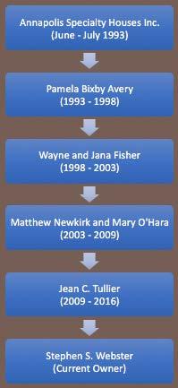
19 505 Burnside: Chain of Ownership 13 recorded transfers:

20 Next Steps: evis Event Visualization Tool Can incorporate images and other data such as our chain of custody data in a database to add points to map the data evis Browser then provides a means to view the data together on the map.

 / Legal desc. / Architectural desc. / Chain of ownership / Photo")
21 Final Products Digitized & Searchable City Directories: 1910, 1924, , 1939, 1956 with Eastport datafied New GIS layers: Hopkins Atlas of AAC Eastport map: 1878 Integrated Sanborn GIS layers for Eastport: 1903, 1908, 1913, 1921, 1930, 1959 Complete Photo Inventory of Eastport Complete Updated Architectural Survey Deep Chain of Ownership Documentation & Methodology for subset of properties Complete 1940 Digitized & Searchable Individual Household Census records for Eastport: 1930, 1920, 1910 & 1900 in progress ArcGIS Online Demo & QGIS Desktop Demo Integrated Eastport Inventory of Properties Form Location / Parcel map / Owner / Tenants / Profession / Race (pre- 1940s) / Legal desc. / Architectural desc. / Chain of ownership / Photo
City of Lockport Historic Resources Survey - Section METHODOLOGY
 2.0 METHODOLOGY Clinton Brown Company PN 07-008 2-1 April 2011 2.0 METHODOLOGY This methodology statement is prepared as part of the project tasks. It outlines the research sources identified, field strategies,
PALS: Neighborhood Identification, City of Frederick, Maryland. David Boston Razia Choudhry Chris Davis Under the supervision of Chao Liu
 PALS: Neighborhood Identification, City of Frederick, Maryland David Boston Razia Choudhry Chris Davis Under the supervision of Chao Liu University of Maryland School of Architecture, Planning & Preservation
GIS ADMINISTRATOR / WEB DEVELOPER EVANSVILLE-VANDERBURGH COUNTY AREA PLAN COMMISSION
 GIS ADMINISTRATOR / WEB DEVELOPER EVANSVILLE-VANDERBURGH COUNTY AREA PLAN COMMISSION SALARY RANGE INITIATION $43,277 SIX MONTHS $45,367 POSITION GRADE PAT VI The Evansville-Vanderburgh County Area Plan
Map and Atlas Collection
 Finding aid prepared by Jillian Fuller This finding aid was produced using the Archivists' Toolkit June 12, 2014 Describing Archives: A Content Standard Ida Public Library May 10, 2014 320 N. State St.
Write a report (6-7 pages, double space) on some examples of Internet Applications. You can choose only ONE of the following application areas:
 on some examples of Internet Applications. You can choose only ONE of the following application areas:") UPR 6905 Internet GIS Homework 1 Yong Hong Guo September 9, 2008 Write a report (6-7 pages, double space) on some examples of Internet Applications. You can choose only ONE of the following application
UPR 6905 Internet GIS Homework 1 Yong Hong Guo September 9, 2008 Write a report (6-7 pages, double space) on some examples of Internet Applications. You can choose only ONE of the following application
GIS = Geographic Information Systems;
 What is GIS GIS = Geographic Information Systems; What Information are we talking about? Information about anything that has a place (e.g. locations of features, address of people) on Earth s surface,
GIS Needs Assessment. for. The City of East Lansing
 GIS Needs Assessment for The City of East Lansing Prepared by: Jessica Moy and Richard Groop Center for Remote Sensing and GIS, Michigan State University February 24, 2000 Executive Summary At the request
Digital Wetlands. Bringing the Field into the Office Through GIS
 Digital Wetlands Bringing the Field into the Office Through GIS Maryland Department of the Environment Wetlands and Waterways Program MDE's Wetlands and Waterways Program seeks to conserve valuable aquatic
Neighborhood Locations and Amenities
 University of Maryland School of Architecture, Planning and Preservation Fall, 2014 Neighborhood Locations and Amenities Authors: Cole Greene Jacob Johnson Maha Tariq Under the Supervision of: Dr. Chao
A Map Through Time Virtual Historic Cities
 A Map Through Time Virtual Historic Cities NEW WAYS OF EXPLORING DIGITAL COLLECTIONS FLORIDA INTERNATIONAL UNIVERSITY JAMIE ROGERS Coral Gables Virtual Historic City & Unearthing St. Augustine s Colonial
Spatial Data Analysis with ArcGIS Desktop: From Basic to Advance
 Spatial Data Analysis with ArcGIS Desktop: From Basic to Advance 1. Course overview Modern environmental, energy as well as resource modeling and planning require huge amount of geographically located
NEW YORK DEPARTMENT OF SANITATION. Spatial Analysis of Complaints
 NEW YORK DEPARTMENT OF SANITATION Spatial Analysis of Complaints Spatial Information Design Lab Columbia University Graduate School of Architecture, Planning and Preservation November 2007 Title New York
Archaeology & Digital Humanities
 WAYNE STATE UNIVERSITY Archaeology & Digital Humanities The D.I.R.T. on Big Data STRENGTHENING THE BIG DATA & ANALYTICS ECOSYSTEM WAYNE STATE UNIVERSITY Krysta Ryzewski Associate Professor of Anthropology
1.1 What is Site Fingerprinting?
 Site Fingerprinting Utilizing GIS/GPS Technology 1.1 What is Site Fingerprinting? Site fingerprinting is a planning tool used to design communities where protection of natural resources is the primary
Continental Divide National Scenic Trail GIS Program
 CDNST Vision Statement: Provide the most accurate geospatial locational information of the Continental Divide Trail and nearby resources to the public as well as help provide internal management information
Exercise 2: Working with Vector Data in ArcGIS 9.3
 Exercise 2: Working with Vector Data in ArcGIS 9.3 There are several tools in ArcGIS 9.3 used for GIS operations on vector data. In this exercise we will use: Analysis Tools in ArcToolbox Overlay Analysis
CHANGES IN ETHNIC GEOGRAPHY IN WATERBURY AS A RESULT OF NATURAL DISASTERS AND URBAN RENEWAL
 G-1302: GIS and Environmental Modeling Final Project Report December 4, 2012 Student: David Perrier Instructor: Tatiana Serebriakova, Ph.D. CHANGES IN ETHNIC GEOGRAPHY IN WATERBURY AS A RESULT OF NATURAL
Megan Durden, North Carolina State Archives Butch Lazorchak, Library of Congress Mark Myers, Kentucky State Archives Best Practices Exchange, Helena,
 GIS are from Mars, Archivists are from Venus: Linking State Government Geospatial Professionals and their Cultural l Heritage Counterparts Megan Durden, North Carolina State Archives Butch Lazorchak, Library
Houston Plat Tracker puts the GIS in Land Development
 Houston Plat Tracker puts the GIS in Land Development Abstract: The Plat Tracker supports Houston's land development approval process. This home grown web-based system includes GIS research tools and a
Presented at ESRI Education User Conference, July 6-8, 2001, San Diego, CA
 Presented at ESRI Education User Conference, July 6-8, 2001, San Diego, CA Irina V. Sharkova, Ph.D., Research Assistant Professor Richard Lycan, Ph.D., Senior Research Associate Population Research Center
The Use of Geographic Information Systems (GIS) by Local Governments. Giving municipal decision-makers the power to make better decisions
 by Local Governments. Giving municipal decision-makers the power to make better decisions") The Use of Geographic Information Systems (GIS) by Local Governments Giving municipal decision-makers the power to make better decisions Case Study: Examples of GIS Usage by Local Governments in North
The Use of Geographic Information Systems (GIS) by Local Governments Giving municipal decision-makers the power to make better decisions Case Study: Examples of GIS Usage by Local Governments in North
Louisiana Transportation Engineering Conference. Monday, February 12, 2007
 Louisiana Transportation Engineering Conference Monday, February 12, 2007 Agenda Project Background Goal of EIS Why Use GIS? What is GIS? How used on this Project Other site selection tools I-69 Corridor
GIS Lecture 5: Spatial Data
 GIS Lecture 5: Spatial Data GIS 1 Outline Vector Data Formats Raster Data Formats Map Projections Coordinate Systems US Census geographic files US Census data files GIS Data Sources GIS 2 Vector Data Formats
Development of an On-Line Interactive GIS Map 1995 OAS Geology Field Trip in NE Oklahoma
 Development of an On-Line Interactive GIS Map 1995 OAS Geology Field Trip in NE Oklahoma JODIE MURRAY BURNS NORTHWEST ARKANSAS COMMUNITY COLLEGE, ROGERS, ARKANSAS FALL 2015 INDEPENDENT STUDY PROJECT PROFESSOR:
GIS Resources for Local Governments
 ISSUE PAPER SERIES GIS Resources for Local Governments February 2018 NEW YORK STATE TUG HILL COMMISSION DULLES STATE OFFICE BUILDING 317 WASHINGTON STREET WATERTOWN, NY 13601 (315) 785-2380 WWW.TUGHILL.ORG
Space Informatics Lab - University of Cincinnati
 Space Informatics Lab - University of Cincinnati USER GUIDE SocScape V 1.0 September 2014 1. Introduction SocScape (Social Landscape) is a GeoWeb-based tool for exploration of patterns in high resolution
Creating A-16 Compliant National Data Theme for Cultural Resources
 Creating A-16 Compliant National Data Theme for Cultural Resources Cultural Resource GIS Facility National Park Service John J. Knoerl Deidre McCarthy Paper 169 Abstract OMB Circular A-16 defines a set
Frequently Asked Questions about MnDOT s Railroad Map Conversion Project
 Frequently Asked Questions about MnDOT s Railroad Map Conversion Project What were the main objectives of the project? What are the results and end products? What can these railroad maps be used for? Who
Working with Census 2000 Data from MassGIS
 Tufts University GIS Tutorial Working with Census 2000 Data from MassGIS Revised September 26, 2007 Overview In this tutorial, you will use pre-processed census data from Massachusetts to create maps of
COURSE SCHEDULE, GRADING, and READINGS
 COURSE SCHEDULE, GRADING, and READINGS Note: All academic classes will be held in the GIS lab at Royal Thimphu College. These dates are listed here. Other days will involve travel or days off, and the
Office of Geographic Information Systems
 Winter 2007 Department Spotlight SWCD GIS by Dave Holmen, Dakota County Soil and Water Conservation District The Dakota County Soil and Water Conservation District (SWCD) has collaborated with the Dakota
These modules are covered with a brief information and practical in ArcGIS Software and open source software also like QGIS, ILWIS.
 Online GIS Training and training modules covered are: 1. ArcGIS, Analysis, Fundamentals and Implementation 2. ArcGIS Web Data Sharing 3. ArcGIS for Desktop 4. ArcGIS for Server These modules are covered
Sharing GIS to Empower the End User David Wray, Roanoke County, Virginia
 Sharing GIS to Empower the End User David Wray, Roanoke County, Virginia Sharing GIS to Empower the End User Roanoke County, Virginia Roanoke County, Virginia Population: 92,901 Area: 251 Square Miles
GIS Visualization: A Library s Pursuit Towards Creative and Innovative Research
 GIS Visualization: A Library s Pursuit Towards Creative and Innovative Research Justin B. Sorensen J. Willard Marriott Library University of Utah justin.sorensen@utah.edu Abstract As emerging technologies
SOLUTIONS ADVANCED GIS. TekMindz are developing innovative solutions that integrate geographic information with niche business applications.
 ADVANCED GIS SOLUTIONS TekMindz are developing innovative solutions that integrate geographic information with niche business applications. TEK INDZ TM GIS Services Overview At the leading edge of geospatial
Annual TTFO Meeting April 10, 2018 Michael J. Wittman, P.S. Chief Surveyor / GIS Coordinator
 Annual TTFO Meeting April 10, 2018 Michael J. Wittman, P.S. Chief Surveyor / GIS Coordinator Text Book Definition: Layman Terms: An organized collection of hardware, software and geographic data designed
CUNY Tax Lots, New York NY, Sept 2016
 Page 1 of 6 Metadata format: ISO 19139 CUNY Tax Lots, New York NY, Sept 2016 ISO 19139 metadata content Resource Identification Information Spatial Representation Information Reference System Information
Algorithms for GIS csci3225
 Algorithms for GIS csci3225 Laura Toma Bowdoin College Spatial analysis: the beginnings Finding: nb. cholera deaths aer spatially clustered around the Broad St pump 1848, London, John Snow Claim: Cholera
Office of Geographic Information Systems
 Office of Geographic Information Systems Print this Page Spring 2008 - Desktop GIS: Collecting Features from Orthos By Joe Sapletal, GISP Keeping up with the growth of our area over the last ten years
Techniques for Science Teachers: Using GIS in Science Classrooms.
 Techniques for Science Teachers: Using GIS in Science Classrooms. After ESRI, 2008 GIS A Geographic Information System A collection of computer hardware, software, and geographic data used together for
Reference: 4880(DOP.ADA)1136 Subject: Survey on the integration of geographic information systems into postal address development
1136 Subject: Survey on the integration of geographic information systems into postal address development") International Bureau Weltpoststrasse 4 P.O. Box 312 3000 BERNE 15 SWITZERLAND To: Union member countries Regulators Designated operators T +41 31 350 31 11 F +41 31 350 31 10 www.upu.int For information
International Bureau Weltpoststrasse 4 P.O. Box 312 3000 BERNE 15 SWITZERLAND To: Union member countries Regulators Designated operators T +41 31 350 31 11 F +41 31 350 31 10 www.upu.int For information
Institutional Research with Public Data and Open Source Software
 2017 Institutional Research with Public Data and Open Source Software DUE1304591, 1644409, 1700496 Opinions expressed are those of the authors and not necessarily those of the National Science Foundation.
Geographic Systems and Analysis
 Geographic Systems and Analysis New York University Robert F. Wagner Graduate School of Public Service Instructor Stephanie Rosoff Contact: stephanie.rosoff@nyu.edu Office hours: Mondays by appointment
BROOKINGS May
 Appendix 1. Technical Methodology This study combines detailed data on transit systems, demographics, and employment to determine the accessibility of jobs via transit within and across the country s 100
An Alternate Career Choice for the Geography Major: Map, GIS, or Geographic Information Librarianship
 An Alternate Career Choice for the Geography Major: Map, GIS, or Geographic Information Librarianship Katherine H. Weimer Texas A&M University Libraries SWAAG 2007 - Bryan, Texas Overview of today s talk
Managing Parcels in ArcGIS 10
 Managing Parcels in ArcGIS 10 ArcGIS Geodatabase Editing Workflows Editing Maps Tim Hensley Esri Solution Engineer Karen Lowrey Esri Geospatial Analyst Basemaps Public Access Value Analysis ArcGIS 10 Parcel
What is GIS? Arizona Maps & GIS Spatial datasets Library GIS Services More Web resources GIS-AZUL HOME
 Research by SUBJECT: Geographic Information Systems The University of Arizona Library What is GIS? Arizona Maps & GIS Spatial datasets Library GIS Services More Web resources GIS-AZUL HOME GEOGRAPHIC INFORMATION
Introduction to ArcGIS Maps for Office. Greg Ponto Scott Ball
 Introduction to ArcGIS Maps for Office Greg Ponto Scott Ball Agenda What is Maps for Office? Platform overview What are Apps for the Office? ArcGIS Maps for Office features - Visualization - Geoenrichment
Canadian Historical GIS Partnership Development: Taking Steps for Historical Mapping in Canada
 Canadian Historical GIS Partnership Development: Taking Steps for Historical Mapping in Canada Byron Moldofsky Manager, GIS and Cartography Office Department of Geography and Planning University of Toronto
Current Functions (Enter categories from instructions) 02G04: Commerce/Trade - tavern 14D09: Transportation automotive service
 02G04: Commerce/Trade - tavern 14D09: Transportation automotive service") Site Inventory Form State Inventory No. 29-03500 New Supplemental State Historical Society of Iowa Part of a district with known boundaries (enter inventory no.) 29-03522 (November 2005) Relationship:
Site Inventory Form State Inventory No. 29-03500 New Supplemental State Historical Society of Iowa Part of a district with known boundaries (enter inventory no.) 29-03522 (November 2005) Relationship:
Digital Tax Maps Westport Island Project Summary
 Digital Tax Maps Westport Island Project Summary Presented to the: Mid-Coast Regional Planning Commission Creating GIS-Based Digital Tax Maps And Linked Assessment Records For Small Towns on a Budget Dennis
Oakland County Parks and Recreation GIS Implementation Plan
 Oakland County Parks and Recreation GIS Implementation Plan TABLE OF CONTENTS 1.0 Introduction... 3 1.1 What is GIS? 1.2 Purpose 1.3 Background 2.0 Software... 4 2.1 ArcGIS Desktop 2.2 ArcGIS Explorer
New Land Cover & Land Use Data for the Chesapeake Bay Watershed
 New Land Cover & Land Use Data for the Chesapeake Bay Watershed Why? The Chesapeake Bay Program (CBP) partnership is in the process of improving and refining the Phase 6 suite of models used to inform
Historic Cultural Properties Inventory (HCPI) Base Form (FORM 1)
 Base Form (FORM 1)") Historic Cultural Properties Inventory (HCPI) Base Form (FORM 1) Historic Preservation Division, New Mexico Office of Cultural Affairs For HPD Office use only: HCPI No. District No. NRHP: SRCP: Criteria:
Historic Cultural Properties Inventory (HCPI) Base Form (FORM 1) Historic Preservation Division, New Mexico Office of Cultural Affairs For HPD Office use only: HCPI No. District No. NRHP: SRCP: Criteria:
Chesapeake Bay Remote Sensing Pilot Executive Briefing
 Chesapeake Bay Remote Sensing Pilot Executive Briefing Introduction In his Executive Order 13506 in May 2009, President Obama stated The Chesapeake Bay is a national treasure constituting the largest estuary
FHWA Planning Data Resources: Census Data Planning Products (CTPP) HEPGIS Interactive Mapping Portal
 HEPGIS Interactive Mapping Portal") FHWA Planning Data Resources: Census Data Planning Products (CTPP) HEPGIS Interactive Mapping Portal Jeremy Raw, P.E. FHWA, Office of Planning, Systems Planning and Analysis August 2017 Outline Census
FHWA Planning Data Resources: Census Data Planning Products (CTPP) HEPGIS Interactive Mapping Portal Jeremy Raw, P.E. FHWA, Office of Planning, Systems Planning and Analysis August 2017 Outline Census
Rural Louisiana. A quarterly publication of the Louisiana Tech Rural Development Center
 Rural Louisiana A quarterly publication of the Louisiana Tech Rural Development Center Volume 4, No. 1, Fall 2009 Editor: Aaron K. Lusby Director, Asst. Professor Newsletter design: Stephanie Tidwell Student
2015 NYS Geospatial Applications Awards Competition Entry Form
 2015 NYS Geospatial Applications Awards Competition Entry Form Please use the below template to submit your entry for the 2015 NYS Geospatial Applications Awards Competition. By entering the competition,
GIS for ChEs Introduction to Geographic Information Systems
 GIS for ChEs Introduction to Geographic Information Systems AIChE Webinar John Cirucci 1 GIS for ChEs Introduction to Geographic Information Systems What is GIS? Tools and Methods Applications Examples
SECTION 4 PARCEL IDENTIFIERS 4.1 LONGITUDE AND LATITUDE
 SECTION 4 PARCEL IDENTIFIERS 4.1 LONGITUDE AND LATITUDE Most maps must be drawn in such a way that points and areas can be located accurately on the earth's surface and described objectively. A uniform
GEOGRAPHIC INFORMATION SYSTEMS Session 8
 GEOGRAPHIC INFORMATION SYSTEMS Session 8 Introduction Geography underpins all activities associated with a census Census geography is essential to plan and manage fieldwork as well as to report results
GEOGRAPHIC INFORMATION SYSTEMS SPECIALIST 3 DEFINITION:
 Hunterdon County Department of Planning and Land Use Vacancy: Geographic Information Systems Specialist 3 Full Time: 40 Hours per Week Compensation: $42,000.00 per year GEOGRAPHIC INFORMATION SYSTEMS SPECIALIST
GIS. in the City of Lewiston Maine
 GIS in the City of Lewiston Maine The purpose of this slideshow is to provide an overview of the city GIS and how it is used, maintained and accessed in-house as well as by the public. Please simply hit
Use of Geospatial Data: Philippine Statistics Authority 1
 Use of Geospatial Data: Philippine Statistics Authority 1 1 Presentation by Lisa Grace S. Bersales at the UNSC 2016 side event on Geospatial information and earth observations: supporting official statistics
Exercise 2: Working with Vector Data in ArcGIS 9.3
 Exercise 2: Working with Vector Data in ArcGIS 9.3 There are several tools in ArcGIS 9.3 used for GIS operations on vector data. In this exercise we will use: Analysis Tools in ArcToolbox Overlay Analysis
Maryland State Geographic Information Committee
 MD IMAP 3.0 Next generation of MD imap platform running on Esri s ArcGIS Enterprise Promoting authoritative data sharing among State agencies via Portal for ArcGIS Centralization of GIS infrastructure
How GIS can be used for improvement of literacy and CE programmes
 How GIS can be used for improvement of literacy and CE programmes Training Workshop for Myanmar Literacy Resource Center (MLRC) ( Yangon, Myanmar, 11 20 October 2000 ) Presented by U THEIN HTUT GEOCOMP
GIScience: Current Technology. Michael F. Goodchild University of California Santa Barbara
 GIScience: Current Technology Michael F. Goodchild University of California Santa Barbara What is a GIS? A class of software designed to handle geographic information and perform virtually any conceivable
Ephemeral Cities Erich Kesse March
 Florida s Ephemeral Cities Erich Kesse - kesse@ufl.edu - 2004 March Objectives Create an historic atlas of Florida cities, using historic maps as GIS layers Link historical resources to the geo-temporal
Learning ArcGIS: Introduction to ArcCatalog 10.1
 Learning ArcGIS: Introduction to ArcCatalog 10.1 Estimated Time: 1 Hour Information systems help us to manage what we know by making it easier to organize, access, manipulate, and apply knowledge to the
GIS Level 2. MIT GIS Services
 GIS Level 2 MIT GIS Services http://libraries.mit.edu/gis Email: gishelp@mit.edu TOOLS IN THIS WORKSHOP - Definition Queries - Create a new field in the attribute table - Field Calculator - Add XY Data
Preparation of Database for Urban Development
 Preparation of Database for Urban Development By PunyaP OLI, 1. Chairman, ERMC (P) Ltd., Kathmandu, Nepal. Email: punyaoli@ermcnepal.com 2. Coordinator, Himalayan College of Geomatic Engineering and Land
Keeping Maps Safe and Accessible: Digitization and Preservation at the Library of Congress
 Keeping Maps Safe and Accessible: Digitization and Preservation at the Library of Congress September 27, 2017 p.1 Agenda Jacqueline Nolan, Cartographer Colleen Cahill, Digital Conversion Coordinator Geography
An Assessment of People, Place and Business on Syracuse s Near Northside
 An Assessment of People, Place and Business on Syracuse s Near Northside May 2013 Report produced by Jon Glass, Kelly Montague and Mark Pawliw Edited by Jon Glass and Jonnell Robinson Syracuse Community
NR402 GIS Applications in Natural Resources
 NR402 GIS Applications in Natural Resources Lesson 1 Introduction to GIS Eva Strand, University of Idaho Map of the Pacific Northwest from http://www.or.blm.gov/gis/ Welcome to NR402 GIS Applications in
Mapping the Route Identifying and Consulting with HS2 s Impacted Populations
 Tuesday 6 December 2016 Mapping the Route Identifying and Consulting with HS2 s Impacted Populations Carry Stephenson, Evelyn Robertson SYSTRA Michael Flynn HS2 Summary Study Context and Objectives Methodology
Pierce Cedar Creek Institute GIS Development Final Report. Grand Valley State University
 Pierce Cedar Creek Institute GIS Development Final Report Grand Valley State University Major Goals of Project The two primary goals of the project were to provide Matt VanPortfliet, GVSU student, the
Enterprise GIS Meeting RFP Midpeninsula Regional Open Space District
 Enterprise GIS Meeting RFP Midpeninsula Regional Open Space District Meeting will began at 10:00 AM Welcome to the meeting. You should hear music and voices in the background. If you cannot connect properly
GIS and Forest Engineering Applications FE 357 Lecture: 2 hours Lab: 2 hours 3 credits
 GIS and Forest Engineering Applications FE 357 Lecture: 2 hours Lab: 2 hours 3 credits Instructor: Michael Wing Assistant Professor Forest Engineering Department Oregon State University Peavy Hall 275
Regional GIS Presentation for Small and Large Jurisdictions. Michelle E. Fults GIS Manager January 8, 2009
 Regional GIS Presentation for Small and Large Jurisdictions Michelle E. Fults GIS Manager January 8, 2009 Presentation Contributions from Juston Manville Henrico County Kevin Nelson Hanover County Mark
Merging statistics and geospatial information
 Merging statistics and geospatial information Demography / Commuting / Spatial planning / Registers Mirosław Migacz Chief GIS Specialist Janusz Dygaszewicz Director Central Statistical Office of Poland
Lecture 1 Introduction to GIS. Dr. Zhang Spring, 2017
 Lecture 1 Introduction to GIS Dr. Zhang Spring, 2017 Topics of the course Using and making maps Navigating GIS Map design Working with spatial data Geoprocessing Spatial data infrastructure Digitizing
GIS Quick Facts. CIVL 1101 GIS Quick Facts 1/5.
 CIVL 1101 1/5 What is GIS? Geographic Information Systems (GIS) provide a platform for displaying and analyzing spatial data. GIS systems allow you to view multiple layers of data simultaneously. GIS is
A Method for Mapping Settlement Area Boundaries in the Greater Golden Horseshoe
 A Method for Mapping Settlement Area Boundaries in the Greater Golden Horseshoe Purpose This paper describes a method for mapping and measuring the lands designated for growth and urban expansion in the
ESRI Survey Summit August Clint Brown Director of ESRI Software Products
 ESRI Survey Summit August 2006 Clint Brown Director of ESRI Software Products Cadastral Fabric How does Cadastral fit with Survey? Surveyors process raw field observations Survey measurements define high-order
Introduction to Google Mapping Tools
 Introduction to Google Mapping Tools Google s Mapping Tools Explore geographic data. Organize your own geographic data. Visualize complex data. Share your data with the world. Tell your story and educate
Administrative Data Research Facility Linked HMDA and ACS Database
 University of Pennsylvania ScholarlyCommons 2017 ADRF Network Research Conference Presentations ADRF Network Research Conference Presentations 11-2017 Administrative Data Research Facility Linked HMDA
The Dance Hall Goes in What School District?
 The Dance Hall Goes in What School District? Vern C. Svatos Jarrod S. Doucette Abstract This paper presents the results of a GIS mapping effort created for the Delaware State Department of Education using
Teaching GIS for Land Surveying
 Teaching GIS for Land Surveying Zhanjing (John) Yu Evergreen Valley College, San Jose, California James Crossfield California State University at Fresno, Fresno California 7/13/2006 1 Outline of the Presentation
The Next Generation GIS/LIS A Surveys Information System Integrated within a GIS
 The Next Generation GIS/LIS A Surveys Information System Integrated within a GIS Michael F. WEIR, USA Key words: Linking, Snapping, GIS, Measurements, Measurement Data, GIS Features, Spatial Quality. SUMMARY
OPEN ACCESS GEOLOGY: USING THE INSTITUTIONAL REPOSITORY TO HOST STATE GEOLOGICAL SURVEY PUBLICATIONS
 OPEN ACCESS GEOLOGY: USING THE INSTITUTIONAL REPOSITORY TO HOST STATE GEOLOGICAL SURVEY PUBLICATIONS Lisa Johnston and Harvey Thorleifson Science and Engineering Library, University of Minnesota, 108 Walter
GIS for the Non-Expert
 GIS for the Non-Expert Ann Forsyth University of Minnesota February 2006 GIS for the Non-Expert 1. Definitions and problems 2. Measures being tested in Twin Cities Walking Study Basic approach, data, variables
Presented by: Bryan Bloch GIS Specialist DNREC Division of Watershed Stewardship
 Presented by: Bryan Bloch GIS Specialist DNREC Division of Watershed Stewardship Bryan Hall, AICP Sussex County Circuit Rider Planner, Office of State Planning Coordination, OMB November 19, 2012 UD Sustainable
Data Creation and Editing
 11.520:A Workshop on Geographical Information Systems 1.188: Urban Planning and Social Science Laboratory Data Creation and Editing Based in part on notes by Prof. Joseph Ferreira and Michael Flaxman Lulu
Town of Taos Request for Proposal Historic Preservation GIS Geodatabase Project April 2007
 Town of Taos Request for Proposal Historic Preservation GIS Geodatabase Project April 2007 1. Background The Town of Taos is requesting proposals from qualified firms or a team of firms who can develop
Using GIS Online for tracking development of roadway construction plans. Tom Cox Viraj Perera
 Using GIS Online for tracking development of roadway construction plans Tom Cox Viraj Perera 9 Districts District 6 Located in the Capital City Springfield, IL LAND OF LINCOLN Home to: Abraham Lincoln
Navigating to Success: Finding Your Way Through the Challenges of Map Digitization
 Library Faculty Presentations Library Faculty/Staff Scholarship & Research 10-15-2011 Navigating to Success: Finding Your Way Through the Challenges of Map Digitization Cory K. Lampert University of Nevada,
Lakeway s first 300 homes / Old Lakeway Neighborhood Project
 Lakeway s first 300 homes / Old Lakeway Neighborhood Project Preserving Lakeway s history through its homes and forming a neighborhood known as Old Lakeway Today Brief backgrounder on the Project Updates:
Explore. history landscapes family.
 Explore history landscapes family www.explorethepast.co.uk Contents From the team Section 1 Researching Worcestershire Section 2 Local Studies & Archaeology Reference Library Section 3 Maps and plans Accessing
Medical GIS: New Uses of Mapping Technology in Public Health. Peter Hayward, PhD Department of Geography SUNY College at Oneonta
 Medical GIS: New Uses of Mapping Technology in Public Health Peter Hayward, PhD Department of Geography SUNY College at Oneonta Invited research seminar presentation at Bassett Healthcare. Cooperstown,