Geography 128 Winter Quarter Lecture 5: What is Analytical Cartography?
|
|
|
- Cameron Byrd
- 6 years ago
- Views:
Transcription

1 Geography 128 Winter Quarter 2017 Lecture 5: What is Analytical Cartography?


2 What is Cartography? Cartography - the science, technology and art of making maps. Matthew Hampton, 2007, A Mosaic of Space, Time, and Order The Portland, Oregon, Super Region ClaudiaGraphics, map.htm


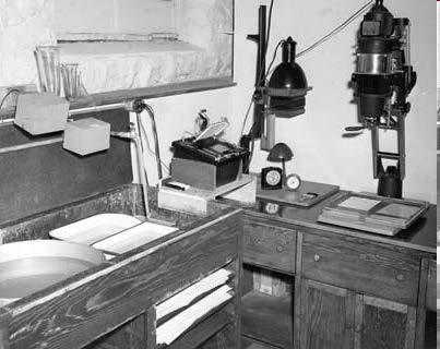
3 Maps in the first half of the 20 th Century Normandy map, 1944 Technology: Manual drafting and layout, Photo and Lithographic reproduction Distribution: Newspapers, books, magazine, sheet maps
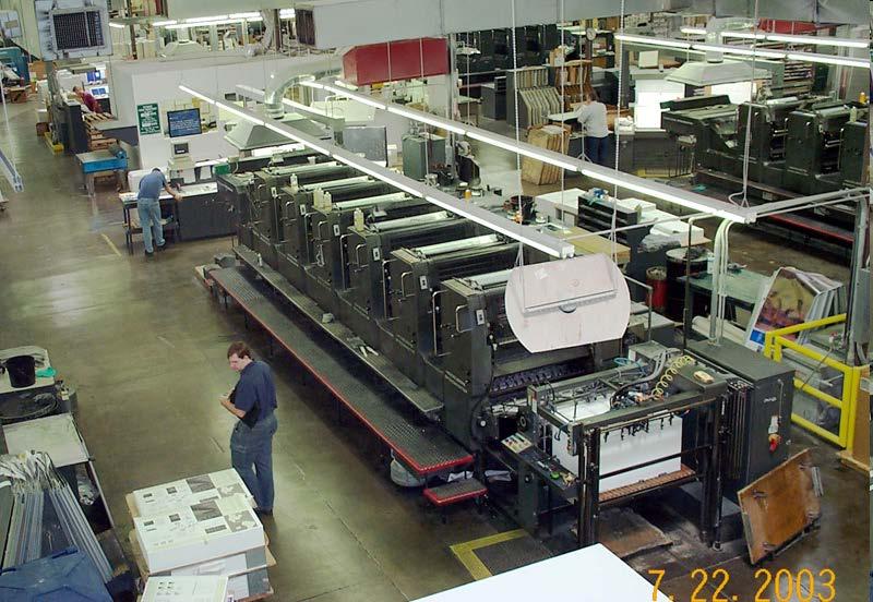
4 Lithography (Offset printing) and Photography

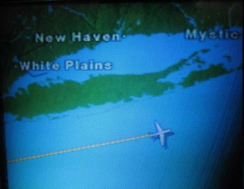
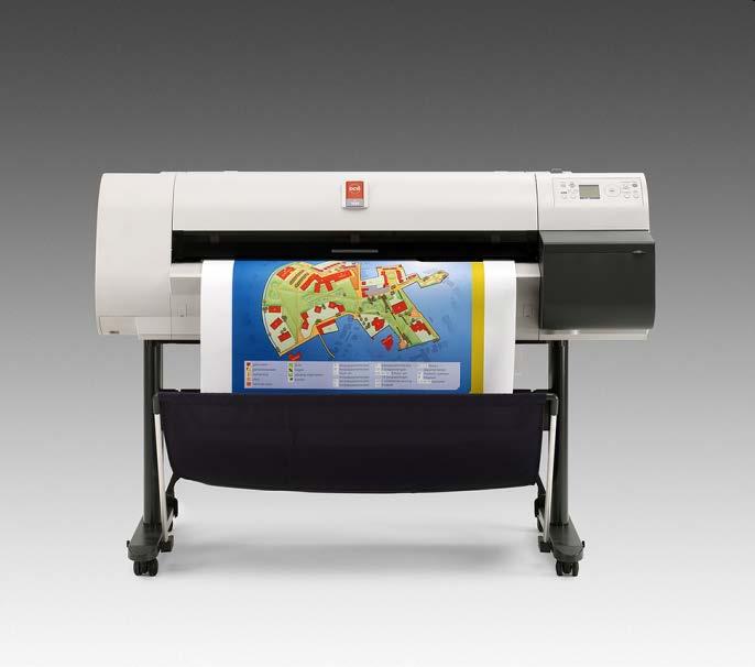

5 Now replaced by InkJet technology and LED displays/projectors


6 Origins of Computing Charles Babbage: Difference Engine 1820s Jacquard Loom in use in India (Assam, January 2011) Hollerith Tabulator 1890 Census Jacquard s Loom 1805


7 Census Mapping 1950 UNIVAC 1980 GBF/DIME 1990 TIGER


 until 1989")

8 Enter the Computer SAGE and the Cold War Developed by MIT Lincoln Laboratory, IBM and others. Operational in 1959 Part of North American Aerospace Defense Command (NORAD) until 1989 Servomechanisms Laboratory, under the direction of Jay Forrester (Systems dynamics)

9 Early Computer Cartography
10 Early Computer-made Maps

11 Evolution of Computer Cartography


12 What is Computer Cartography? Computer Cartography the science, technology and art of making maps using computers and other new technologies


13 What have computers done to Cartography? - Faster and Easier, even Cheaper Computer graphics for map drawing New survey technologies for map update Computer data transfer via mobile storage and networks for map sharing Computer printing technology for map production


14 What have computers done to Cartography? - More Accurate and More Precise New survey technologies increase the accuracy of geographic information Computer graphics and plotting/printing vs. manual drawing Computers enable more significant digits more precise

15 Dru Smith: NGS on the future of geopositioning Richard Langley on the Future of GPS 2004: $2000 and a few minutes gets you 1 cm 2084: $10 and a few seconds gets you 1 mm 2010 May 17 NRC Workshop on NGA future directions 14


16 What have computers done to Cartography? - The Design Loop!!

17 What have computers done to Cartography? The democratization of cartography - Anyone can do Cartography?


18 What have computers done to Cartography? BUT anyone can do Cartography!

19 What have computers done to Cartography? - The birth of Analytical Cartography & GIS Born in the 1960s and 1970s From technological focus to theoretical focus The early Geographic Information Systems are more like computer mapping programs plus a few data management functions.
 solving cartographic problems")

20 What is Analytical Cartography? Tobler (1966) solving cartographic problems Tobler (1976) mathematical and analytical parts of cartography that remain independent of technology


21 Methods of Analytical Cartography Computer science Data base science Computation Logic and programming Mathematics and Statistics Matrix theory Set theory Algebra Trigonometry Topology Spatial statistics Cartography Map data Transformations Representation Symbolization Layout and design Psychology Map reading and interpretation Navigation and route finding User design

22 Typical Topics in Analytical Cartography Map Transformation Sampling Critical Features Map Generalization Shape Analysis Data Models and Structures Analytical Visualization A lot more
 in Special Issue of Cartography and GIS")
23 Review of Applications by W. R. Franklin (2000) in Special Issue of Cartography and GIS on Analytical Cartography


24 Franklin s Topics Terrain visibility Map overlay Calculation with partial information Mobility and routing Interpolation and approximation Representing curves and surfaces Interpolation on terrain surfaces Surface flow
25 Franklin s themes Interplay between theory and applications Algorithm and data structure design principles Robustness in computations and solutions Interoperability
26 Franklin s Future Applications of Analytical Cartography The best method for representing terrain Can we represent the terrain by the features that people would use to describe it? Conflating data across layers, e.g. topography and hydrology Dealing with true 3D, e.g. for geology Establishing error bounds on output as a function of approximations in the algorithm and uncertainties in the data is critical Consider "just good enough" computation, or, how do we tum input uncertainty and output sensitivity to our advantage? Finally, an open theoretical issue is why some simple algorithms, which have intolerable worst-case times, work so well in practice (e.g. Dykstra)
27 Computer Mapping Fragments Geographic Information Systems Geographic Information Science GeoComputation Geospatial data GeoVisualization Visual Analytics Remote Sensing Image processing GeoAnalytics GeoWeb GeoSensor


28 Trends Integration and interoperability Mobile Ubiquitous Web enabled Interactive Animated Information visualization and spatialization


29 Finally BOTH analytical AND computer cartography are necessary Technology and theory Current technology IS the computer Technology a moving target What information in Geography 128 will be technological history in 5-10 years?
30 Analytical cartography The mathematical and analytical parts of cartography that remain independent of technology that applies to both paper and online maps and their digital databases Defined in term of its development, origins, scope and conceptual content and applications Flexible approach to GIScience and GeoComputation Now has books, journal special issues, classes Bridges Cartography and Computer Science
GIS = Geographic Information Systems;
 What is GIS GIS = Geographic Information Systems; What Information are we talking about? Information about anything that has a place (e.g. locations of features, address of people) on Earth s surface,
Software. People. Data. Network. What is GIS? Procedures. Hardware. Chapter 1
 People Software Data Network Procedures Hardware What is GIS? Chapter 1 Why use GIS? Mapping Measuring Monitoring Modeling Managing Five Ms of Applied GIS Chapter 2 Geography matters Quantitative analyses
An Information Model for Maps: Towards Cartographic Production from GIS Databases
 An Information Model for s: Towards Cartographic Production from GIS Databases Aileen Buckley, Ph.D. and Charlie Frye Senior Cartographic Researchers, ESRI Barbara Buttenfield, Ph.D. Professor, University
Evolution or Devolution of Cartographic Education?
 Evolution or Devolution of Cartographic Education? Transformations in Teaching Cartographic Concepts and Techniques Aileen Buckley Cartographic Researcher, ESRI, Inc. abuckley@esri.com Terminology UCGIS*
Geography 128 Winter Quarter Lecture 18: A Selective History of Computer Mapping
 Geography 128 Winter Quarter 2017 Lecture 18: A Selective History of Computer Mapping If you would understand anything, observe its beginning and its development. Aristotle Cartography and Computer Science
Spatial Analysis and Modeling (GIST 4302/5302) Guofeng Cao Department of Geosciences Texas Tech University
 Guofeng Cao Department of Geosciences Texas Tech University") Spatial Analysis and Modeling (GIST 4302/5302) Guofeng Cao Department of Geosciences Texas Tech University TTU Graduate Certificate Geographic Information Science and Technology (GIST) 3 Core Courses and
Spatial Analysis and Modeling (GIST 4302/5302) Guofeng Cao Department of Geosciences Texas Tech University TTU Graduate Certificate Geographic Information Science and Technology (GIST) 3 Core Courses and
What is GIS? G: Geographic, Geospatial, Geo
 GEOG 488/588: GIS I Introduction Instructor: Geoffrey Duh TA: David Graves What is GIS? G: Geographic, Geospatial, Geo Alternatives: Spatial Information Systems, Land Information Systems Geography diverse
Basics of GIS reviewed
 Basics of GIS reviewed Martin Breunig Karlsruhe Institute of Technology martin.breunig@kit.edu GEODETIC INSTITUTE, DEPARTMENT OF CIVIL ENGINEERING, GEO AND ENVIRONMENTAL SCIENCES, CHAIR IN GEOINFORMATICS
Aileen Buckley, Ph.D. and Charlie Frye
 An Information Model for Maps: Towards Production from GIS Databases Aileen Buckley, Ph.D. and Charlie Frye Researchers, ESRI GIS vs. cart GIS Outline of the presentation Introduction Differences between
3D MAPS SCALE, ACCURACY, LEVEL OF DETAIL
 26 th International Cartographic Conference August 25 30, 2013 Dresden, Germany 3D MAPS SCALE, ACCURACY, LEVEL OF DETAIL Prof. Dr. Temenoujka BANDROVA Eng. Stefan BONCHEV University of Architecture, Civil
a system for input, storage, manipulation, and output of geographic information. GIS combines software with hardware,
 Introduction to GIS Dr. Pranjit Kr. Sarma Assistant Professor Department of Geography Mangaldi College Mobile: +91 94357 04398 What is a GIS a system for input, storage, manipulation, and output of geographic
Sources of Imagery and GIS Data Layers (Last updated October 2005)
") Sources of Imagery and GIS Data Layers (Last updated October 2005) The question of where to find data is one often asked by beginners in precision agriculture and other geospatial projects. The following
Sources of Imagery and GIS Data Layers (Last updated October 2005) The question of where to find data is one often asked by beginners in precision agriculture and other geospatial projects. The following
You are Building Your Organization s Geographic Knowledge
 You are Building Your Organization s Geographic Knowledge And Increasingly Making it Available Sharing Data Publishing Maps and Geo-Apps Developing Collaborative Approaches Citizens Knowledge Workers Analysts
Introduction to Geographic Information Systems
 Introduction to Geographic Information Systems Geography 176A Fall 2013 The sequence Geog 176A - Introduction to Geographic Information Systems, 4.0, Clarke Introduction to modern spatial data processing,
THEMATIC CARTOGRAPHY AND GEOVISUALIZATION PDF
 THEMATIC CARTOGRAPHY AND GEOVISUALIZATION PDF ==> Download: THEMATIC CARTOGRAPHY AND GEOVISUALIZATION PDF THEMATIC CARTOGRAPHY AND GEOVISUALIZATION PDF - Are you searching for Thematic Cartography And
What you learned. Lecture 27: Class Summary. Maps and geodesy. How you learned it
 What you learned Geography 12: Maps and Spatial Reasoning Lecture 27: Class Summary Professor Keith Clarke Map geometry, construction and content Practical map use, reading and navigation Map representation
Statistical perspectives on spatial social science
 Statistical perspectives on spatial social science Discussion Sarah Nusser (nusser@iastate.edu) Center for Survey Statistics and Methodology Department of Statistics Iowa State University Morris Hansen
Thales Canada, System Division. BattleView: Integrating ArcGIS Into Canadian Army s Command And Control Application
 BattleView: Integrating ArcGIS Into Canadian Army s Command And Control Application BattleView Overview Canadian Army s command and control (C2) application Deployed in army headquarters unit and above
GIS Applications on Environmental Education in Taiwan
 GIS Applications on Environmental Education in Taiwan Track: Education Authors: Yu-Chen Lai, Mei-Ling Yeh, Tien-Yin Chou Abstract GIS is a perfect vehicle to deliver environmental knowledge and spatial
WELCOME. To GEOG 350 / 550 Introduction to Geographic Information Science: Third Lecture
 WELCOME To GEOG 350 / 550 Introduction to Geographic Information Science: Third Lecture 1 Lecture 3: Overview Geographic Information Systems (GIS) A brief history of GIS Sources of information for GIS
Geographical Information System (GIS) Prof. A. K. Gosain
 Prof. A. K. Gosain") Geographical Information System (GIS) Prof. A. K. Gosain gosain@civil.iitd.ernet.in Definition of GIS GIS - Geographic Information System or a particular information system applied to geographical data
Geographical Information System (GIS) Prof. A. K. Gosain gosain@civil.iitd.ernet.in Definition of GIS GIS - Geographic Information System or a particular information system applied to geographical data
Cartographic Workshop
 http://lazarus.elte.hu/cet/ Cartographic Workshop One of the roles of the ICA, Commission on Education and Training is to provide member nations with cartographic workshop experiences that enhance the
M.Y. Pior Faculty of Real Estate Science, University of Meikai, JAPAN
 GEOGRAPHIC INFORMATION SYSTEM M.Y. Pior Faculty of Real Estate Science, University of Meikai, JAPAN Keywords: GIS, rasterbased model, vectorbased model, layer, attribute, topology, spatial analysis. Contents
The Relevance of Cartography. Dubai 2015, Georg Gartner
 The Relevance of Cartography Dubai 2015, Georg Gartner Where are we? Data! Data? We are not short of data Technologies! Technologies? We are not short of technologies Data-driven and technology-driven
Introduction to Geographic Information Systems
 Geog 58 Introduction to Geographic Information Systems, Fall, 2003 Page 1/8 Geography 58 Introduction to Geographic Information Systems Instructor: Lecture Hours: Lab Hours: X-period: Office Hours: Classroom:
Geometric Algorithms in GIS
 Geometric Algorithms in GIS GIS Visualization Software Dr. M. Gavrilova GIS Software for Visualization ArcView GEO/SQL Digital Atmosphere AutoDesk Visual_Data GeoMedia GeoExpress CAVE? Visualization in
FUTURE DATA. Future data Future hardware Future software Future issues. Getting Started With GIS. Chapter 10
 THE FUTURE OF GIS Getting Started With GIS Chapter 10 GIS Futures Future data Future hardware Future software Future issues Dursun Z. ªeker Theme of the book GIS's place in understanding geographic distributions
DP Project Development Pvt. Ltd.
 Dear Sir/Madam, Greetings!!! Thanks for contacting DP Project Development for your training requirement. DP Project Development is leading professional training provider in GIS technologies and GIS application
Geographic Information Systems (GIS) in Environmental Studies ENVS Winter 2003 Session III
 in Environmental Studies ENVS Winter 2003 Session III") Geographic Information Systems (GIS) in Environmental Studies ENVS 6189 3.0 Winter 2003 Session III John Sorrell York University sorrell@yorku.ca Session Purpose: To discuss the various concepts of space,
Geographic Information Systems (GIS) in Environmental Studies ENVS 6189 3.0 Winter 2003 Session III John Sorrell York University sorrell@yorku.ca Session Purpose: To discuss the various concepts of space,
These modules are covered with a brief information and practical in ArcGIS Software and open source software also like QGIS, ILWIS.
 Online GIS Training and training modules covered are: 1. ArcGIS, Analysis, Fundamentals and Implementation 2. ArcGIS Web Data Sharing 3. ArcGIS for Desktop 4. ArcGIS for Server These modules are covered
Research Group Cartography
 Research Group Cartography Research Group Cartography Towards supporting wayfinding LBS components 1. Mobile devices 2. Communication Network 3. Positioning Component 4. Service and Application Provider
First Exam. Geographers Tools: Automated Map Making. Digitizing a Map. Digitized Map. Revising a Digitized Map 9/22/2016.
 First Exam Monday, September 26, 206. Combination of multiple choice questions. Bring a #2 pencil with eraser. Based on class lectures and chapter. If you miss the exam, an essay style make up exam will
Smart Data Collection and Real-time Digital Cartography
 Smart Data Collection and Real-time Digital Cartography Yuji Murayama and Ko Ko Lwin Division of Spatial Information Science Faculty of Life and Environmental Sciences University of Tsukuba IGU 2013 1
The 2010 Census Successful Because of GIS
 The 2010 Census Successful Because of GIS Timothy F. Trainor Chief, Geography Division, U.S. Census Bureau Vice President, International Cartographic Association Establishing the Framework of the Operation
ANALYSIS OF GLACIER CHANGE IN THE SIERRA NEVADA PORTLAND STATE UNIVERSITY DEPARTMENT OF GEOLOGY BRADLEY BUSELLI
 ANALYSIS OF GLACIER CHANGE IN THE SIERRA NEVADA PORTLAND STATE UNIVERSITY DEPARTMENT OF GEOLOGY BRADLEY BUSELLI Study area: Sierra Nevada (Glaciers, 2015) Closer look (Glaciers, 2015) Primary goal: Research
GISc Technician model. Diploma in GISc / Geoinformatics NQF level 6. Minimum 240 credits
 GISc Technician model. Diploma in GISc / Geoinformatics NQF level. Minimum 20 credits The workforce and competency requirements of a GISc technicians is defined in terms of the Geomatics Act 19 of 2013,
Learning Computer-Assisted Map Analysis
 Learning Computer-Assisted Map Analysis by Joseph K. Berry* Old-fashioned math and statistics can go a long way toward helping us understand GIS Note: This paper was first published as part of a three-part
Applying GIS to Hydraulic Analysis
 Texas A&M University Department of Civil Engineering CVEN689 Applications of GIS to Civil Engineering Instructor: Francisco Olivera, Ph.D., P.E. Applying GIS to Hydraulic Analysis Lim, Chae Kwan April
Canadian Board of Examiners for Professional Surveyors Core Syllabus Item C 5: GEOSPATIAL INFORMATION SYSTEMS
 Study Guide: Canadian Board of Examiners for Professional Surveyors Core Syllabus Item C 5: GEOSPATIAL INFORMATION SYSTEMS This guide presents some study questions with specific referral to the essential
Experiences and Directions in National Portals"
 FIG Seminar on e-land Administration Innsbruck/Austria 2-4 June 2004 "ESRI's Experiences and Directions in National Portals" Kevin Daugherty Cadastral/Land Records Manager ESRI Topic Points Technology
Crime Analyst Extension. Christine Charles
 Crime Analyst Extension Christine Charles ccharles@esricanada.com Agenda Why use Crime Analyst? Overview Tools Demo Interoperability With our old software it could take a police officer up to forty minutes
Lecture 5. Representing Spatial Phenomena. GIS Coordinates Multiple Map Layers. Maps and GIS. Why Use Maps? Putting Maps in GIS
 Lecture 5 Putting Maps in GIS GIS responds to three fundamental questions by automating spatial data: What is where? Why is it there? GIS reveals linkages unevenly distributed social, economic and environmental
Esri Defense Mapping: Cartographic Production. Bo King
 Esri Defense Mapping: Cartographic Production Bo King Agenda Esri Defense Mapping: Cartographic Production Solution Overview Desktop Cartographic Production Workflow - Create Rapid Graphic Product On Demand
How a Media Organization Tackles the. Challenge Opportunity. Digital Gazetteer Workshop December 8, 2006
 A Case-Study-In-Process: How a Media Organization Tackles the Georeferencing Challenge Opportunity Digital Gazetteer Workshop December 8, 2006 to increase and diffuse geographic knowledge 1888 to 2006:
GIS Workshop Data Collection Techniques
 GIS Workshop Data Collection Techniques NOFNEC Conference 2016 Presented by: Matawa First Nations Management Jennifer Duncan and Charlene Wagenaar, Geomatics Technicians, Four Rivers Department QA #: FRG
Techniques for Science Teachers: Using GIS in Science Classrooms.
 Techniques for Science Teachers: Using GIS in Science Classrooms. After ESRI, 2008 GIS A Geographic Information System A collection of computer hardware, software, and geographic data used together for
Version 1.1 GIS Syllabus
 GEOGRAPHIC INFORMATION SYSTEMS CERTIFICATION Version 1.1 GIS Syllabus Endorsed 1 Version 1 January 2007 GIS Certification Programme 1. Target The GIS certification is aimed at: Those who wish to demonstrate
What is GIS? ESRI Canada. August 2011
 What is GIS? ESRI Canada August 2011 Geography Matters! Environmental Park Management Agriculture Public Utilities Health Care Emergency 911 Real Estate Marketing Environmental What are the effects of
WELCOME. to EEOS Computer Applications in Geography. Getting Started with Geographic Information Systems
 WELCOME to EEOS 265 - Computer Applications in Geography Getting Started with Geographic Information Systems What will you learn? An overview of GIS How GIS data are captured, stored, retrieved, analyzed
Welcome to GST 101: Introduction to Geospatial Technology. This course will introduce you to Geographic Information Systems (GIS), cartography,
, cartography,") Welcome to GST 101: Introduction to Geospatial Technology. This course will introduce you to Geographic Information Systems (GIS), cartography, remote sensing, and spatial analysis through a series of
Welcome to GST 101: Introduction to Geospatial Technology. This course will introduce you to Geographic Information Systems (GIS), cartography, remote sensing, and spatial analysis through a series of
Chapter 10: The Future of GIS Why Speculate? 10.2 Future Data 10.3 Future Hardware 10.4 Future Software 10.5 Some Future Issues and Problems
 Chapter 10: The Future of GIS 10.1 Why Speculate? 10.2 Future Data 10.3 Future Hardware 10.4 Future Software 10.5 Some Future Issues and Problems Theme of the Course GIS's place in understanding geographic
GEOBIA state of the art, science or technology
 GEOBIA state of the art, science or technology Paul Aplin School of Geography, paul.aplin@nottingham.ac.uk Geographic Object-Based Image Analysis Aplin et al., 1999, Remote Sensing of Environment Progress?
Why Is It There? Attribute Data Describe with statistics Analyze with hypothesis testing Spatial Data Describe with maps Analyze with spatial analysis
 6 Why Is It There? Why Is It There? Getting Started with Geographic Information Systems Chapter 6 6.1 Describing Attributes 6.2 Statistical Analysis 6.3 Spatial Description 6.4 Spatial Analysis 6.5 Searching
Geo Business Gis In The Digital Organization
 We have made it easy for you to find a PDF Ebooks without any digging. And by having access to our ebooks online or by storing it on your computer, you have convenient answers with geo business gis in
Overview key concepts and terms (based on the textbook Chang 2006 and the practical manual)
") Introduction Geo-information Science (GRS-10306) Overview key concepts and terms (based on the textbook 2006 and the practical manual) Introduction Chapter 1 Geographic information system (GIS) Geographically
Introduction Geo-information Science (GRS-10306) Overview key concepts and terms (based on the textbook 2006 and the practical manual) Introduction Chapter 1 Geographic information system (GIS) Geographically
USING GIS CARTOGRAPHIC MODELING TO ANALYSIS SPATIAL DISTRIBUTION OF LANDSLIDE SENSITIVE AREAS IN YANGMINGSHAN NATIONAL PARK, TAIWAN
 CO-145 USING GIS CARTOGRAPHIC MODELING TO ANALYSIS SPATIAL DISTRIBUTION OF LANDSLIDE SENSITIVE AREAS IN YANGMINGSHAN NATIONAL PARK, TAIWAN DING Y.C. Chinese Culture University., TAIPEI, TAIWAN, PROVINCE
GEOG 508 GEOGRAPHIC INFORMATION SYSTEMS I KANSAS STATE UNIVERSITY DEPARTMENT OF GEOGRAPHY FALL SEMESTER, 2002
 GEOG 508 GEOGRAPHIC INFORMATION SYSTEMS I KANSAS STATE UNIVERSITY DEPARTMENT OF GEOGRAPHY FALL SEMESTER, 2002 Course Reference #: 13210 Meeting Time: TU 2:05pm - 3:20 pm Meeting Place: Ackert 221 Remote
Massachusetts Institute of Technology Department of Urban Studies and Planning
 Massachusetts Institute of Technology Department of Urban Studies and Planning 11.520: A Workshop on Geographic Information Systems 11.188: Urban Planning and Social Science Laboratory GIS Principles &
Lecture 11. Data Standards and Quality & New Developments in GIS
 Lecture 11 Data Standards and Quality & New Developments in GIS Lecture 11: Outline I. Data Standards and Quality 1. Types of Spatial Data Standards 2. Data Accuracy II. New Developments/The Future of
History & Scope of Remote Sensing FOUNDATIONS
 History & Scope of Remote Sensing FOUNDATIONS Lecture Overview Introduction Overview of visual information Power of imagery Definition What is remote sensing? Definition standard for class History of Remote
Innovation. The Push and Pull at ESRI. September Kevin Daugherty Cadastral/Land Records Industry Solutions Manager
 Innovation The Push and Pull at ESRI September 2004 Kevin Daugherty Cadastral/Land Records Industry Solutions Manager The Push and The Pull The Push is the information technology that drives research and
Fundamentals of ArcGIS Desktop Pathway
 Fundamentals of ArcGIS Desktop Pathway Table of Contents ArcGIS Desktop I: Getting Started with GIS 3 ArcGIS Desktop II: Tools and Functionality 5 Understanding Geographic Data 8 Understanding Map Projections
Introduction to Geographic Information Systems Dr. Arun K Saraf Department of Earth Sciences Indian Institute of Technology, Roorkee
 Introduction to Geographic Information Systems Dr. Arun K Saraf Department of Earth Sciences Indian Institute of Technology, Roorkee Lecture 01 What is Geographic Information Systems? I welcome to this
ESRI Survey Summit August Clint Brown Director of ESRI Software Products
 ESRI Survey Summit August 2006 Clint Brown Director of ESRI Software Products Cadastral Fabric How does Cadastral fit with Survey? Surveyors process raw field observations Survey measurements define high-order
How to Pick a GIS. GIS Software Chapter 8 in Longley, Goodchild, Maguire, and Rhind,, 2001
 How to Pick a GIS GIS Software Chapter 8 in Longley, Goodchild, Maguire, and Rhind,, 2001 How to Pick a GIS Evolution of GIS software Architecture of GIS software Types of software Example products The
Development and operation of GIS exercise materials for undergraduate students
 Development and operation of GIS exercise materials for undergraduate students Since around 2000, GIS researchers in Japan have collaborated to provide materials for GIS lecture classes for university
UNIT 4: USING ArcGIS. Instructor: Emmanuel K. Appiah-Adjei (PhD) Department of Geological Engineering KNUST, Kumasi
 Department of Geological Engineering KNUST, Kumasi") UNIT 4: USING ArcGIS Instructor: Emmanuel K. Appiah-Adjei (PhD) Department of Geological Engineering KNUST, Kumasi Getting to Know ArcGIS ArcGIS is an integrated collection of GIS software products ArcGIS
UNIT 4: USING ArcGIS Instructor: Emmanuel K. Appiah-Adjei (PhD) Department of Geological Engineering KNUST, Kumasi Getting to Know ArcGIS ArcGIS is an integrated collection of GIS software products ArcGIS
The Global Statistical Geospatial Framework and the Global Fundamental Geospatial Themes
 The Global Statistical Geospatial Framework and the Global Fundamental Geospatial Themes Sub-regional workshop on integration of administrative data, big data and geospatial information for the compilation
A Review: Geographic Information Systems & ArcGIS Basics
 A Review: Geographic Information Systems & ArcGIS Basics Geographic Information Systems Geographic Information Science Why is GIS important and what drives it? Applications of GIS ESRI s ArcGIS: A Review
THE NEW TECHNOLOGICAL ADVANCES IN CARTOGRAPHY
 Distr.: LIMITED ECA/NRD/CART. 9/ETH. 6 October 1996 Original: ENGLISH Ninth United Nations Regional Cartographic Conference for Africa Addis Ababa, Ethiopia 11-15 November 1996 THE NEW TECHNOLOGICAL ADVANCES
Introduction to Geographic Information Systems (GIS): Environmental Science Focus
: Environmental Science Focus") Introduction to Geographic Information Systems (GIS): Environmental Science Focus September 9, 2013 We will begin at 9:10 AM. Login info: Username:!cnrguest Password: gocal_bears Instructor: Domain: CAMPUS
Introduction to Geographic Information Systems (GIS): Environmental Science Focus September 9, 2013 We will begin at 9:10 AM. Login info: Username:!cnrguest Password: gocal_bears Instructor: Domain: CAMPUS
Ladder versus star: Comparing two approaches for generalizing hydrologic flowline data across multiple scales. Kevin Ross
 Ladder versus star: Comparing two approaches for generalizing hydrologic flowline data across multiple scales Kevin Ross kevin.ross@psu.edu Paper for Seminar in Cartography: Multiscale Hydrography GEOG
State and National Standard Correlations NGS, NCGIA, ESRI, MCHE
 GEOGRAPHIC INFORMATION SYSTEMS (GIS) COURSE DESCRIPTION SS000044 (1 st or 2 nd Sem.) GEOGRAPHIC INFORMATION SYSTEMS (11, 12) ½ Unit Prerequisite: None This course is an introduction to Geographic Information
Information Cartography
 Information Cartography The use of Geographic Information Systems (GIS) to visualize nongeographic data Utilizes Geographic Information Science to develop models and organize information--not an art form
geographic patterns and processes are captured and represented using computer technologies
 Proposed Certificate in Geographic Information Science Department of Geographical and Sustainability Sciences Submitted: November 9, 2016 Geographic information systems (GIS) capture the complex spatial
FUNDAMENTALS OF GEOINFORMATICS PART-II (CLASS: FYBSc SEM- II)
") FUNDAMENTALS OF GEOINFORMATICS PART-II (CLASS: FYBSc SEM- II) UNIT:-I: INTRODUCTION TO GIS 1.1.Definition, Potential of GIS, Concept of Space and Time 1.2.Components of GIS, Evolution/Origin and Objectives
FUNDAMENTALS OF GEOINFORMATICS PART-II (CLASS: FYBSc SEM- II) UNIT:-I: INTRODUCTION TO GIS 1.1.Definition, Potential of GIS, Concept of Space and Time 1.2.Components of GIS, Evolution/Origin and Objectives
Geog183: Cartographic Design and Geovisualization Winter Quarter 2017 Lecture 6: Map types and Data types
 Geog183: Cartographic Design and Geovisualization Winter Quarter 2017 Lecture 6: Map types and Data types Data types Data dimension: Point, Line, Area, Volume (Text) Data continuity: Discrete, Point, Polygon:
Lecture 12. Data Standards and Quality & New Developments in GIS
 Lecture 12 Data Standards and Quality & New Developments in GIS Lecture 12: Outline I. Data Standards and Quality 1. Types of Spatial Data Standards 2. Data Accuracy 3. III. Documenting Spatial Data Accuracy
Geog418: Introduction to GIS Fall 2011 Course Syllabus. Textbook: Introduction to Geographic Information Systems edited by Chang (6th ed.
 Geog418: Introduction to GIS Fall 2011 Course Syllabus AH 1320 3:30 4:45 p.m.tr Instructor: Dr. Shunfu Hu Office: AH1413 Telephone 650-2281 Office hours: 10:00 11:00 a.m. TR or by appointment (shu@siue.edu)
GEOGRAPHY 350/550 Final Exam Fall 2005 NAME:
 1) A GIS data model using an array of cells to store spatial data is termed: a) Topology b) Vector c) Object d) Raster 2) Metadata a) Usually includes map projection, scale, data types and origin, resolution
IMPLEMENTAION OF GIS TECHNOLOGY IN THE NILE AND ITS WADIS ABSTRACT
 IMPLEMENTAION OF GIS TECHNOLOGY IN THE NILE AND ITS WADIS Eng. NADIA M. ABD EI- SALAM 1 Dr. ABDEL AZIZ TAREK M. 2 ABSTRACT Traditional methods have been used for several years for map production of the
Available online at Analele Stiintifice ale Universitatii Al. I. Cuza din Iasi Seria Geologie 58 (1) (2012) 53 58
 (2012) 53 58") Available online at http://geology.uaic.ro/auig/ Analele Stiintifice ale Universitatii Al. I. Cuza din Iasi Seria Geologie 58 (1) (2012) 53 58 AUI GEOLOGIE GIS database for mineral resources: case study
Available online at http://geology.uaic.ro/auig/ Analele Stiintifice ale Universitatii Al. I. Cuza din Iasi Seria Geologie 58 (1) (2012) 53 58 AUI GEOLOGIE GIS database for mineral resources: case study
Conceptual Aspects of 3D Map Integration in Interactive School Atlases
 Conceptual Aspects of 3D Map Integration in Interactive School Atlases Christian Haeberling Hans Rudolf Baer Institute of Cartography ETH Zurich 8093 Zurich, Switzerland E-Mail: haeberling@karto.baug.ethz.ch
MAKING MAPS Cartographic Design & Principles Winter 2018
 MAKING MAPS Cartographic Design & Principles Winter 2018 Cartography the art, science, and technology of making maps, together with their study as scientific documents and works of art - The International
Geospatial capabilities, spatial data and services provided by Military Geographic Service
 Geospatial capabilities, spatial data and services provided by Military Geographic Service LtC Mariyan Markov PhD CONTENTS 1. INTRODUCTION - Workflow - Data sources remote sensing, direct field observation.
Office of Geographic Information Systems
 Winter 2007 Department Spotlight SWCD GIS by Dave Holmen, Dakota County Soil and Water Conservation District The Dakota County Soil and Water Conservation District (SWCD) has collaborated with the Dakota
3/29/11. Why bother with tools? Incorporating Decision Support Tools into Climate Adaptation Planning. A Simplified Planning Process
 Incorporating Decision Support Tools into Climate Adaptation Planning Why bother with tools? Tools don t eliminate complexity but they can help deal with it" Tools can:"! Help incorporate science into
GIS Geographical Information Systems
 Chapter Two GIS Geographical Information Systems Chapter Two GIS Geographical Information Systems Chapter Two GIS (Geographical Information Systems) 2.1 Introduction In most cases of our day life, information
GIS APPLICATIONS IN SOIL SURVEY UPDATES
 GIS APPLICATIONS IN SOIL SURVEY UPDATES ABSTRACT Recent computer hardware and GIS software developments provide new methods that can be used to update existing digital soil surveys. Multi-perspective visualization
NR402 GIS Applications in Natural Resources
 NR402 GIS Applications in Natural Resources Lesson 1 Introduction to GIS Eva Strand, University of Idaho Map of the Pacific Northwest from http://www.or.blm.gov/gis/ Welcome to NR402 GIS Applications in
Indiana University Maps
 Indiana University 9.28.09 Maps Maps Mission Action Cause related cartography at National Geographic Networks and Complex Systems This talk series is open to all Indiana University faculty and students
Chapter 5. GIS The Global Information System
 Chapter 5 GIS The Global Information System What is GIS? We have just discussed GPS a simple three letter acronym for a fairly sophisticated technique to locate a persons or objects position on the Earth
GeoWEPP Tutorial Appendix
 GeoWEPP Tutorial Appendix Chris S. Renschler University at Buffalo - The State University of New York Department of Geography, 116 Wilkeson Quad Buffalo, New York 14261, USA Prepared for use at the WEPP/GeoWEPP
ADVANCES OF INTERDISCIPLINARY CARTOGRAPHY IN THE HIMALAYAN MOUNTAINS
 Geographia Technica, Special Issue, 2010, pp. 120 to 125 ADVANCES OF INTERDISCIPLINARY CARTOGRAPHY IN THE HIMALAYAN MOUNTAINS David SCHOBESBERGER 1, Karel KRIZ 1 ABSTRACT: This paper follows up on the
COURSE SCHEDULE, GRADING, and READINGS
 COURSE SCHEDULE, GRADING, and READINGS Note: All academic classes will be held in the GIS lab at Royal Thimphu College. These dates are listed here. Other days will involve travel or days off, and the
An Introduction to Geographic Information System
 An Introduction to Geographic Information System PROF. Dr. Yuji MURAYAMA Khun Kyaw Aung Hein 1 July 21,2010 GIS: A Formal Definition A system for capturing, storing, checking, Integrating, manipulating,
EXPLANATION OF G.I.S. PROJECT ALAMEIN FOR WEB PUBLISHING
 EXPLANATION OF G.I.S. PROJECT ALAMEIN FOR WEB PUBLISHING Compilato: Andrea De Felici Rivisto: Approvato: Daniele Moretto ARIDO S President Versione: 1.0 Distribuito: 28/06/2013 1 TABLE OF CONTENTS 1. INTRODUCTION..3
History of Cartography,
 Maps History of Cartography, the art and science of making maps ~2300 BC ~600 BC Early oldest known maps: Babylonian clay tablets. Greek and Roman Ptolemy s (about AD 85-165) "world map" depicted the Old
Animating Maps: Visual Analytics meets Geoweb 2.0
 Animating Maps: Visual Analytics meets Geoweb 2.0 Piyush Yadav 1, Shailesh Deshpande 1, Raja Sengupta 2 1 Tata Research Development and Design Centre, Pune (India) Email: {piyush.yadav1, shailesh.deshpande}@tcs.com
Introduction to Geographic Information Science. Updates/News. Last Lecture 1/23/2017. Geography 4103 / Spatial Data Representations
 Geography 4103 / 5103 Introduction to Geographic Information Science Spatial Data Representations Updates/News Waitlisted students First graded lab this week: skills learning Instructional labs vs. independence