WELCOME. to EEOS Computer Applications in Geography. Getting Started with Geographic Information Systems
|
|
|
- Stephen Hampton
- 6 years ago
- Views:
Transcription
1 WELCOME to EEOS Computer Applications in Geography Getting Started with Geographic Information Systems
2 What will you learn? An overview of GIS How GIS data are captured, stored, retrieved, analyzed & displayed Where to go for information (self-help) GIS software and its functionality Where GIS is going How to use a GIS (ArcGIS) GIS problem solving
3 Introduction to GIS Science / Study / Systems What subject matter does geography study? How do geographers see things / what approach do they take? What is the role of geographic information? What is GIS? How does a GIS work? What components does a GIS include?

4 Is Geography Just Place Names? Many think of geography solely as knowing place name attributes

5 There Are Many Other Sorts of Geographic Information World Population by Nation The darker the red fill, the greater the population

6 We Can Also Map Rates of Change World Population Growth Rate by Nation The darker the red, the greater the population growth

7 Geography Also Looks at the Physical Environment Cloud Cover Land Cover Sea Temperature
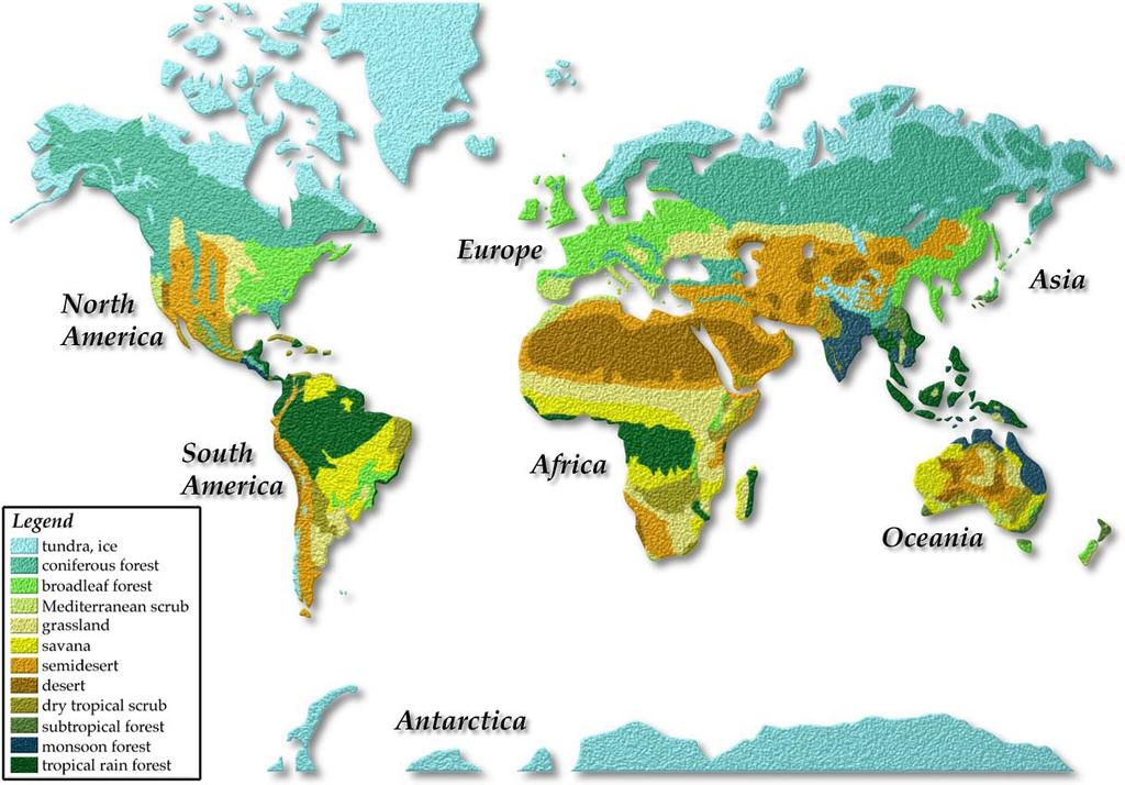
8 Vegetation Biome Map
9 What Do Geographers Do? Primarily, geographers make maps maps of place names maps of human population and its growth maps of temperature maps of the spatial distribution of vegetation, etc. Maps are the means by which geographers work through the analysis of many maps, geographers produce new maps that provide insights into some spatial phenomenon. Maps are a final product: They are the medium that geographers use to present spatial information
10 The First Law of Geography Tobler s Law: The central tenet of Geography is that location matters for understanding a wide variety of phenomena. Everything is related to everything else, but things that are closer together are more related to each other than those that are further apart
11 Geographers Perspectives on the World Location matters Real-world relationships Horizontal connections between places Importance of scale (both in time and space)
12 Geographic Information Includes knowledge about where something is Includes knowledge about what is at a given location Can be very detailed: e.g. the locations of all buildings in a city or the locations of all trees in a forest stand Or it can be very coarse: e.g. the population density of an entire country or the global sea surface temperature distribution There is always a spatial component associated with geographic information
13 Lecture 1: What is a GIS? 1.1 Getting Started 1.2 Some Definitions of GIS 1.3 A Brief History of GIS 1.4 Sources of Information on GIS
14 Lecture 1: What is a GIS? GIS (usually) stands for Geographic Information System. It is comprised of hardware, software, network, data, and trained personnel to support the capture, management, manipulation, analysis, and display of geographically referenced data for solving complex municipal management and planning problems, and for serving the public better and more efficiently.
15 Lecture 1: What is a GIS? A geographic information or geographical information system (GIS) is a system for creating, storing, analyzing and managing spatial data and associated attributes. In the strictest sense, it is a computer system capable of integrating, storing, editing, analyzing, sharing, and displaying geographically-referenced information. In a more generic sense, GIS is a tool that allows users to create interactive queries (user created searches), analyze the spatial information, and edit data. Geographical Information Science is the science underlying the applications and systems, taught as a degree program by universities. (
16 Where did GIS come from? GIS is built upon knowledge from geography, cartography, computer science and mathematics Geographic Information Science is a new interdisciplinary field built out of the use and theory of GIS
17 Defining GIS Different definitions of a GIS have evolved in different areas and disciplines a toolbox an information system an approach to science an multi-billion dollar business plays an important role in society All GIS definitions recognize that spatial data are unique because they are linked to maps (Space matters!) A GIS at least consists of a database, map information, and a computer-based link between them
18 Spatial and non-spatial data Part Number Quantity Description Wheel spoke Ball bearing Wheel rim Tire Handlebars Crimes during 2003 Date Location Type 22-Jan 123 James St. Robbery 24-Jan 22 Smith St. Burglary 10-Feb 9 Elm St. #4A Assault 13-Feb 12 Fifth Avenue Breaking and Entering 14-Feb 17 Del Playa Drunk and Disorderly
19 Definition 1: A GIS is a toolbox "a powerful set of tools for storing and retrieving at will, transforming and displaying spatial data from the real world for a particular set of purposes" (Burrough, 1986, p. 6). "automated systems for the capture, storage, retrieval, analysis, and display of spatial data." (Clarke, 1995, p. 13).
20 Definition 2: A GIS is an information system "An information system that is designed to work with data referenced by spatial or geographic coordinates. In other words, a GIS is both a database system with specific capabilities for spatially-referenced data, as well as a set of operations for working with the data" (Star and Estes, 1990, p. 2).
21 Dueker's 1979 definition (p. 20) has survived the test of time. "A geographic information system is a special case of information systems where the database consists of observations on spatially distributed features, activities or events, which are definable in space as points, lines, or areas. A geographic information system manipulates data about these points, lines, and areas to retrieve data for ad hoc queries and analyses" (Dueker, 1979, p 106).
22 The Feature Model Dueker's definition uses the feature model of geographic space. The standard feature model divides a mapped landscape up into features, that can be points, lines, or areas. Using a GIS involves capturing the spatial distribution of features by measurement of the world or of maps (making observations?). Almost all human activity and natural phenomena are spatially distributed, so can be studied using a GIS. A GIS uses map features to manage data.
23 Observations? Observations of features, activities, and events. The term feature is a term from cartography, meaning thing to be placed on a map. Point features: These are features with only a location, no length or area. e.g. On campus, the following are well represented as point features: The Old Well, the flag pole, etc. Line features: These are feature with several locations strung out along the line in sequence, and are too narrow to represent their width. e.g. roads, rivers, etc. Area features: These consist of one or more lines that form a loop. e.g. shorelines enclosing a lake.
24 Geographic Features (Vector Model) (x,y) (x,y) (x,y) (x,y) (x,y) point line polygon (area) A point: specified by a pair of (x,y) coordinates, representing a feature that is too small to have length and area. A line: formed by joining two points, representing features too narrow to have areas A polygon (area): formed by a joining multiple points that enclose an area (x,y) (x,y) (x,y) (x,y) (x,y)


, a line fea")
 and area")
25 FEATURES The Feature Model POINT LINE AREA Figure 1.2 The Feature Model: Examples of a point feature (38 foot elevation bench mark), a line fea ture (road, contours) and area features (reservoir, vegetation).
26 Dueker (continued) A GIS is flexible enough to be used for ad hoc query and analysis (in space, about place) A GIS can do analysis, modeling and prediction
27 A Hybrid Definition Dueker s definition only applies to the vector model of the real world, which represents the real world on maps as point, line, and area features. In fact, there are other spatial data models of the world (e.g. the raster model) where that definition does not apply. A more useful definition is a hybrid: GIS is an information system that allows for capture, storage, retrieval, analysis and display of spatial data.
28 Definition 3: GIS is an approach to science Geographic Information Science is research both on and with GIS. The technology of GIS has become much simpler, more distributed, cheaper and has crossed the boundary into disciplines such as anthropology, epidemiology, facilities management, forestry, geology, and business. GIS is used as a new approach to science.
29 Definition 4: GIS is a multibillion dollar business The growth of GIS has been a marketing phenomenon of amazing breadth and depth and will remain so for many years to come. Clearly, GIS will integrate its way into our everyday life to such an extent that it will soon be impossible to imagine how we functioned before
30 Definition 5: GIS plays a role in society. Nick Chrisman (1999) has defined GIS as organized activity by which people measure and represent geographic phenomena, and then transform these representations into other forms while interacting with social structures.
31 How Does GIS Work? Geographic Information System Chain of Operations Capturing Data Storing and Retrieving Data Analysis And Display of Data
")
32 Capturing Data Capturing Data The first fundamental step is identifying some features or phenomena of interest and creating a digital representation of it (e.g. field work with GPS or any number other ways of producing data)
33 How Does GIS Work? Storing and Retrieving Data The next step is to store the data in a database Database organization is the key to a successful project
34 Simple Database Example Orange Co. Base Data Derived Data Roads Satellite Images Land Cover Cities Rates of Deforestation
35 How Does GIS Work? Analysis And Display of Data Each layer corresponds to a theme in our example database Analysis can be performed on the layers individually or in combination with other layers.
36 How Does GIS Work? Analysis And Display of Data After analysis, the resulting information is communicated, most often through a map The information can then be used to make decisions
37 Components of a GIS GIS Computer Hardware Computer Software Data People/ Process


38 Computer Hardware Computer Hardware Computers Disk storage Digitizers and scanners Printer and plotter output devices

39 Computer Software Computer Software A program like any other, but designed specifically to manage and manipulate spatial data in the ways described previously
40 GIS Software Packages Environmental Systems Research Institute (ESRI) Arc/INFO - originally developed for UNIX systems, the latest version (versions 8.x and 9.x a.k.a. ArcGIS) is now exclusively for PCs ArcView (3.x) developed in parallel for PCs and UNIX systems, replaced by ArcGIS MapInfo Corporation MapInfo: PC-based GIS Clark University IDRISI: PC-based GIS

41 GIS Software Vendors
42 Data Data The geographic information itself, including the location information and attribute information
43 GIS Data Data properties: Spatial data, i.e. data that are associated with geographic locations Data format: digital (analog for traditional paper maps) Data Inputs: sampled from the real world digitizing from paper maps produced by government agencies, e.g. census bureau, USGS, USFS, state government space or airborne remote sensing (NASA, NOAA, commercial, etc.) About 80% of the duration of many large scale GIS projects is concerned with data input and management
44 Components of a GIS GIS Computer Hardware Computer Software Data People/ Process
45 A Brief History of GIS GIS s origins lie in thematic cartography Many planners used the method of map overlay using manual techniques Manual map overlay as a method was first described comprehensively by Jacqueline Tyrwhitt from Britain in a1950 planning textbook Ian McHarg used blacked out transparent overlays for site selection in Design with Nature published in 1969.

46 Tyrwhitt: Town & Country Planning
47 A Brief History of GIS (continued) The 1960s saw many new forms of geographic data and mapping software Computer cartography developed the first basic GIS concepts during the late 1950s and 1960s Linked software modules, rather than stand-alone programs, preceded GISs Early influential data sets were the World Data Bank and the GBF/DIME files by the US Census Bureau Early systems were CGIS, MLMIS, GRID and LUNR The Harvard University ODYSSEY system was influential due to its topological arc-node (vector) data structure in the 70s
48 A Brief History of GIS (continued) GIS was significantly altered by (1) the PC and (2) the workstation During the 1980s, new GIS software could better exploit more advanced hardware 1980s and early 1990s saw GIS mature as a technology The development of Graphical User Interfaces (GUIs) led to GIS's vastly improved ease of use during the 1990s Integration with GPS and remote sensing
49 A Brief History of GIS (continued) GIS owes its birth to a cluster of interrelated events and human interactions in the 1960s, and its spectacular growth to the microcomputer, the workstation, and the Internet.
50 Sources of Information on GIS The amount of information available about GIS can be overwhelming Sources of GIS information include journals and magazines, books, professional societies, the World Wide Web, and conferences GIS has Web pages, network conference groups, professional organizations, and user groups Most colleges and universities now offer GIS classes in geography departments

51 GIS Resources: Conferences
52 Major GIS-Only Journals International Journal of Geographical Information Systems Geographical Systems Transactions in GIS Geospatial solutions Geoworld
53 Specialty Journals GIS Law GrassClippings GIS Asia/Pacific GIS World Report/CANADA GIS Europe Mapping Awareness
54 Journals that Regularly Contain GIS Papers Annals of the Association of American Geographers Cartographica Cartography and GIS Computers, Environment, and Urban Systems Computers and Geosciences IEEE Transactions on Computer Graphics and Applications Photogrammetric Engineering and Remote Sensing
55 Journals that Occasionally Contain GIS Papers Cartographic Perspectives Journal of Cartography Geocarto International IEEE Geosciences International Journal of Remote Sensing Landscape Ecology Remote Sensing Review Mapping Science and Remote Sensing Infoworld
56 Popular Distribution Magazines Geospatial Solutions GIS Law Geoworld GPS World Mapping awareness/mapping awareness and GIS in Europe/Asia/Africa ArcNews
57 Proceedings of Conferences AUTOCARTO International Symposium on Automated Cartography GIS/LIS. Sponsored by AAG, ACSM, AM/FM, ASPRS, URISA. Held every year, retired in International Advanced Study Symposium on Topological Data Structures for Geographic Information Systems Proceedings International Symposium on Spatial Data Handling. IGU Commission on GIS. SSD Advances in spatial databases
58 Professional Organizations AM/FM International Automated Mapping and Facilities Management. (Now GITA) AAG: The Association of American Geographers. ACSM: American Congress on Surveying and Mapping. ASPRS: American Society for Photogrammetry and Remote Sensing. NACIS: North American Cartographic Information Society. URISA: Urban and Regional Information Systems Association.

59 WWW Resources: Discussion Lists

60 WWW Resources: MassGIS
61 WWW Resources: NSDI

62 WWW Resources: Textbook Pages
63 GIS daily internet news/jobs
64 Introduction to GIS Science / Study / Systems What subject matter does geography study? The spatial organization of any/all phenomena on the surface of the Earth (human and physical) How do geographers see things / what approach do they take? Location matters etc. What is the role of geographic information? Geo. info. is the data geographers analyze
65 Introduction to GIS Science / Study / Systems What is GIS? Several definitions, all relating to approaches to understanding the world in terms of spatial organization of phenomena How does GIS work? The chain of operations involving geographic information What components does a GIS include? Hardware, software, data, and people/process
66 Next Topic: GIS s Roots in Cartography
Introduction to Geographic Information Systems
 Introduction to Geographic Information Systems Geography 176A Fall 2013 The sequence Geog 176A - Introduction to Geographic Information Systems, 4.0, Clarke Introduction to modern spatial data processing,
WELCOME. To GEOG 350 / 550 Introduction to Geographic Information Science
 WELCOME To GEOG 350 / 550 Introduction to Geographic Information Science 1 What will I learn? An overview of Geographic Information Science What is GIScience How does it differ front GISystems How GIS
WELCOME. To GEOG 350 / 550 Introduction to Geographic Information Science: Third Lecture
 WELCOME To GEOG 350 / 550 Introduction to Geographic Information Science: Third Lecture 1 Lecture 3: Overview Geographic Information Systems (GIS) A brief history of GIS Sources of information for GIS
This Week s Topics. GIS and Forest Engineering Applications. FE 257. GIS and Forest Engineering Applications. Instructor Information.
 FE 257. GIS and Forest Engineering Applications Introduction Instructor Information Associate Professor in FERM Department Instructor for FE 257, FE 480, FE 432/532 PhD from Forest Resources with minor
Introduction to Geographic Information Systems (GIS)
") Introduction to Geographic Information Systems (GIS) SGO1910 & SGO4930 Fall Semester 2005 Lecturer: Karen O Brien (karen.obrien@sgeo.uio.no) Lab Instructor: Hallvard Berge (hallvb@student.sv.uio.no) http://www.workingdogweb.com
Introduction to Geographic Information Systems (GIS) SGO1910 & SGO4930 Fall Semester 2005 Lecturer: Karen O Brien (karen.obrien@sgeo.uio.no) Lab Instructor: Hallvard Berge (hallvb@student.sv.uio.no) http://www.workingdogweb.com
EEOS 281 Introduction to Geographic Information Systems
 EEOS 281 Introduction to Geographic Information Systems EEOS 281 Introduction to Geographic Information Systems Course Description: This course is an introductory course in geographic information systems
GIS = Geographic Information Systems;
 What is GIS GIS = Geographic Information Systems; What Information are we talking about? Information about anything that has a place (e.g. locations of features, address of people) on Earth s surface,
Understanding Geographic Information System GIS
 Understanding Geographic Information System GIS What do we know about GIS? G eographic I nformation Maps Data S ystem Computerized What do we know about maps? Types of Maps (Familiar Examples) Street Maps
What is GIS? G: Geographic, Geospatial, Geo
 GEOG 488/588: GIS I Introduction Instructor: Geoffrey Duh TA: David Graves What is GIS? G: Geographic, Geospatial, Geo Alternatives: Spatial Information Systems, Land Information Systems Geography diverse
Techniques for Science Teachers: Using GIS in Science Classrooms.
 Techniques for Science Teachers: Using GIS in Science Classrooms. After ESRI, 2008 GIS A Geographic Information System A collection of computer hardware, software, and geographic data used together for
How to Pick a GIS. GIS Software Chapter 8 in Longley, Goodchild, Maguire, and Rhind,, 2001
 How to Pick a GIS GIS Software Chapter 8 in Longley, Goodchild, Maguire, and Rhind,, 2001 How to Pick a GIS Evolution of GIS software Architecture of GIS software Types of software Example products The
An Introduction to Geographic Information System
 An Introduction to Geographic Information System PROF. Dr. Yuji MURAYAMA Khun Kyaw Aung Hein 1 July 21,2010 GIS: A Formal Definition A system for capturing, storing, checking, Integrating, manipulating,
FUNDAMENTALS OF GEOINFORMATICS PART-II (CLASS: FYBSc SEM- II)
") FUNDAMENTALS OF GEOINFORMATICS PART-II (CLASS: FYBSc SEM- II) UNIT:-I: INTRODUCTION TO GIS 1.1.Definition, Potential of GIS, Concept of Space and Time 1.2.Components of GIS, Evolution/Origin and Objectives
FUNDAMENTALS OF GEOINFORMATICS PART-II (CLASS: FYBSc SEM- II) UNIT:-I: INTRODUCTION TO GIS 1.1.Definition, Potential of GIS, Concept of Space and Time 1.2.Components of GIS, Evolution/Origin and Objectives
NR402 GIS Applications in Natural Resources
 NR402 GIS Applications in Natural Resources Lesson 1 Introduction to GIS Eva Strand, University of Idaho Map of the Pacific Northwest from http://www.or.blm.gov/gis/ Welcome to NR402 GIS Applications in
Introduction to GIS. Dr. M.S. Ganesh Prasad
 Introduction to GIS Dr. M.S. Ganesh Prasad Department of Civil Engineering The National Institute of Engineering, MYSORE ganeshprasad.nie@gmail.com 9449153758 Geographic Information System (GIS) Information
COURSE INTRODUCTION & COURSE OVERVIEW
 week 1 COURSE INTRODUCTION & COURSE OVERVIEW topics of the week Instructor introduction Students introductions Course logistics Course objectives Definition of GIS The story of GIS introductions Who am
ENV208/ENV508 Applied GIS. Week 1: What is GIS?
 ENV208/ENV508 Applied GIS Week 1: What is GIS? 1 WHAT IS GIS? A GIS integrates hardware, software, and data for capturing, managing, analyzing, and displaying all forms of geographically referenced information.
Key Questions and Issues. What is GIS? GIS is to geographic analysis as: What is GIS? 9/3/2013. GEO 327G/386G, UT Austin 1
 What is GIS? Key Questions and Issues Geology Elevation Transportation Hydrography Imagery What is GIS? What are the applications of GIS? How is the real world represented in GIS? What analyses can GIS
SRJC Applied Technology 54A Introduction to GIS
 SRJC Applied Technology 54A Introduction to GIS Overview Lecture of Geographic Information Systems Fall 2004 Santa Rosa Junior College Presented By: Tim Pudoff, GIS Coordinator, County of Sonoma, Information
8/28/2011. Contents. Lecture 1: Introduction to GIS. Dr. Bo Wu Learning Outcomes. Map A Geographic Language.
 Contents Lecture 1: Introduction to GIS Dr. Bo Wu lsbowu@polyu.edu.hk Department of Land Surveying & Geo-Informatics The Hong Kong Polytechnic University 1. Learning outcomes 2. GIS definition 3. GIS examples
Introduction to Geographic Information Systems
 Introduction to Geographic Information Systems Lynn_Carlson@brown.edu 401-863-9917 The Environmental And Remote TecHnologies Lab MacMillan Hall, Room 105 http://www.brown.edu/research/earthlab/ Outline
Introduction to GIS. Geol 4048 Geological Applications of Remote Sensing
 Introduction to GIS Geol 4048 Geological Applications of Remote Sensing GIS History: Before Computers GIS History Using maps for a long time Dr. Roger F. Tomlinson Father of GIS He was an English geographer
University of Lusaka
 University of Lusaka BSPH 315 Health Mapping & GIS Topic: Background of GIS Content: 1. Aim of the course 2. What do you know about GIS? 3. Difference between geographic data and geographic information
INTRODUCTION TO GEOGRAPHIC INFORMATION SYSTEM By Reshma H. Patil
 INTRODUCTION TO GEOGRAPHIC INFORMATION SYSTEM By Reshma H. Patil ABSTRACT:- The geographical information system (GIS) is Computer system for capturing, storing, querying analyzing, and displaying geospatial
a system for input, storage, manipulation, and output of geographic information. GIS combines software with hardware,
 Introduction to GIS Dr. Pranjit Kr. Sarma Assistant Professor Department of Geography Mangaldi College Mobile: +91 94357 04398 What is a GIS a system for input, storage, manipulation, and output of geographic
Introduction to Geographic Information Science. Updates/News. Last Lecture 1/23/2017. Geography 4103 / Spatial Data Representations
 Geography 4103 / 5103 Introduction to Geographic Information Science Spatial Data Representations Updates/News Waitlisted students First graded lab this week: skills learning Instructional labs vs. independence
Chapter 10: The Future of GIS Why Speculate? 10.2 Future Data 10.3 Future Hardware 10.4 Future Software 10.5 Some Future Issues and Problems
 Chapter 10: The Future of GIS 10.1 Why Speculate? 10.2 Future Data 10.3 Future Hardware 10.4 Future Software 10.5 Some Future Issues and Problems Theme of the Course GIS's place in understanding geographic
Fundamentals of Geographic Information System PROF. DR. YUJI MURAYAMA RONALD C. ESTOQUE JUNE 28, 2010
 Fundamentals of Geographic Information System 1 PROF. DR. YUJI MURAYAMA RONALD C. ESTOQUE JUNE 28, 2010 CONTENTS OF THIS LECTURE PRESENTATION Basic concept of GIS Basic elements of GIS Types of GIS data
Display data in a map-like format so that geographic patterns and interrelationships are visible
 Vilmaliz Rodríguez Guzmán M.S. Student, Department of Geology University of Puerto Rico at Mayagüez Remote Sensing and Geographic Information Systems (GIS) Reference: James B. Campbell. Introduction to
M A P T I T U D E A L O W C O S T G I S / D E S K T O P M A P P I N G A L T E R N A T I V E
 M A P T I T U D E A L O W C O S T G I S / D E S K T O P M A P P I N G A L T E R N A T I V E Jeffrey L. Baumann Dispatch & Forest Technology Coordinator South Carolina Forestry Commission Columbia, South
8/27/2015 M. Helper, U. Texas, Austin
 Slide 1 What is GIS? Geology Transportation Hydrography Elevation Imagery Geo327G/386G UT Austin 1 Slide 2 Key Questions and Issues What is GIS? What are the applications of GIS? How is the real world
Introduction-Overview. Why use a GIS? What can a GIS do? Spatial (coordinate) data model Relational (tabular) data model
 data model Relational (tabular) data model") Introduction-Overview Why use a GIS? What can a GIS do? How does a GIS work? GIS definitions Spatial (coordinate) data model Relational (tabular) data model intro_gis.ppt 1 Why use a GIS? An extension
Introduction-Overview Why use a GIS? What can a GIS do? How does a GIS work? GIS definitions Spatial (coordinate) data model Relational (tabular) data model intro_gis.ppt 1 Why use a GIS? An extension
GIS (GEOGRAPHIC INFORMATION SYSTEMS)
") GIS (GEOGRAPHIC INFORMATION SYSTEMS) 1 1. DEFINITION SYSTEM Any organised assembly of resources and procedures united and regulated by interaction or interdependence to complete a set of specific functions.
GIS (GEOGRAPHIC INFORMATION SYSTEMS) 1 1. DEFINITION SYSTEM Any organised assembly of resources and procedures united and regulated by interaction or interdependence to complete a set of specific functions.
Teaching GIS for Land Surveying
 Teaching GIS for Land Surveying Zhanjing (John) Yu Evergreen Valley College, San Jose, California James Crossfield California State University at Fresno, Fresno California 7/13/2006 1 Outline of the Presentation
GIS Geographical Information Systems
 Chapter Two GIS Geographical Information Systems Chapter Two GIS Geographical Information Systems Chapter Two GIS (Geographical Information Systems) 2.1 Introduction In most cases of our day life, information
PC ARC/INFO and Data Automation Kit GIS Tools for Your PC
 ESRI PC ARC/INFO and Data Automation Kit GIS Tools for Your PC PC ARC/INFO High-quality digitizing and data entry Powerful topology building Cartographic design and query Spatial database query and analysis
Application of GIS in Public Transportation Case-study: Almada, Portugal
 Case-study: Almada, Portugal Doutor Jorge Ferreira 1 FSCH/UNL Av Berna 26 C 1069-061 Lisboa, Portugal +351 21 7908300 jr.ferreira@fcsh.unl.pt 2 FSCH/UNL Dra. FCSH/UNL +351 914693843, leite.ines@gmail.com
GIS Geographic Information System
 GIS Geographic Information System Andrea Petroselli Tuscia University, Italy petro@unitus.it SUMMARY Part 1: Part 2: Part 3: Part 4: What is a GIS? Why do we need a GIS? Which are the possibilities of
Popular Mechanics, 1954
 Introduction to GIS Popular Mechanics, 1954 1986 $2,599 1 MB of RAM 2017, $750, 128 GB memory, 2 GB of RAM Computing power has increased exponentially over the past 30 years, Allowing the existence of
Quality and Coverage of Data Sources
 Quality and Coverage of Data Sources Objectives Selecting an appropriate source for each item of information to be stored in the GIS database is very important for GIS Data Capture. Selection of quality
Introduction to GIS I
 Introduction to GIS Introduction How to answer geographical questions such as follows: What is the population of a particular city? What are the characteristics of the soils in a particular land parcel?
Geometric Algorithms in GIS
 Geometric Algorithms in GIS GIS Visualization Software Dr. M. Gavrilova GIS Software for Visualization ArcView GEO/SQL Digital Atmosphere AutoDesk Visual_Data GeoMedia GeoExpress CAVE? Visualization in
Government GIS and its Application for Decision Support
 Government GIS and its Application for Decision Support Zhang Qingpu (Chinese Academy of Surveying and Mapping, Email: zhangqp@casm.ac.cn) Abstract: Application of GIS in government agencies is called
DATA SOURCES AND INPUT IN GIS. By Prof. A. Balasubramanian Centre for Advanced Studies in Earth Science, University of Mysore, Mysore
 DATA SOURCES AND INPUT IN GIS By Prof. A. Balasubramanian Centre for Advanced Studies in Earth Science, University of Mysore, Mysore 1 1. GIS stands for 'Geographic Information System'. It is a computer-based
What are the five components of a GIS? A typically GIS consists of five elements: - Hardware, Software, Data, People and Procedures (Work Flows)
") LECTURE 1 - INTRODUCTION TO GIS Section I - GIS versus GPS What is a geographic information system (GIS)? GIS can be defined as a computerized application that combines an interactive map with a database
LECTURE 1 - INTRODUCTION TO GIS Section I - GIS versus GPS What is a geographic information system (GIS)? GIS can be defined as a computerized application that combines an interactive map with a database
Course overview. Grading and Evaluation. Final project. Where and When? Welcome to REM402 Applied Spatial Analysis in Natural Resources.
 Welcome to REM402 Applied Spatial Analysis in Natural Resources Eva Strand, University of Idaho Map of the Pacific Northwest from http://www.or.blm.gov/gis/ Where and When? Lectures Monday & Wednesday
17/07/ Pick up Lecture Notes... WEBSITE FOR ASSIGNMENTS AND TOOLBOX DEFINITION DEFINITIONS AND CONCEPTS OF GIS
 WEBSITE FOR ASSIGNMENTS AND LECTURE PRESENTATIONS www.franzy.yolasite.com Pick up Lecture Notes... LECTURE 2 PRINCIPLES OF GEOGRAPHICAL INFORMATION SYSTEMS I- GEO 362 Franz Okyere DEFINITIONS AND CONCEPTS
CENSUS MAPPING WITH GIS IN NAMIBIA. BY Mrs. Ottilie Mwazi Central Bureau of Statistics Tel: October 2007
 CENSUS MAPPING WITH GIS IN NAMIBIA BY Mrs. Ottilie Mwazi Central Bureau of Statistics E-mail: omwazi@npc.gov.na Tel: + 264 61 283 4060 October 2007 Content of Presentation HISTORICAL BACKGROUND OF CENSUS
Chapter 5. GIS The Global Information System
 Chapter 5 GIS The Global Information System What is GIS? We have just discussed GPS a simple three letter acronym for a fairly sophisticated technique to locate a persons or objects position on the Earth
Applied Cartography and Introduction to GIS GEOG 2017 EL. Lecture-2 Chapters 3 and 4
 Applied Cartography and Introduction to GIS GEOG 2017 EL Lecture-2 Chapters 3 and 4 Vector Data Modeling To prepare spatial data for computer processing: Use x,y coordinates to represent spatial features
What is GIS? Introduction to data. Introduction to data modeling
 What is GIS? Introduction to data Introduction to data modeling 2 A GIS is similar, layering mapped information in a computer to help us view our world as a system A Geographic Information System is a
FUTURE DATA. Future data Future hardware Future software Future issues. Getting Started With GIS. Chapter 10
 THE FUTURE OF GIS Getting Started With GIS Chapter 10 GIS Futures Future data Future hardware Future software Future issues Dursun Z. ªeker Theme of the book GIS's place in understanding geographic distributions
ENVIRONMENTAL MONITORING Vol. II - Applications of Geographic Information Systems - Ondieki C.M. and Murimi S.K.
 APPLICATIONS OF GEOGRAPHIC INFORMATION SYSTEMS Ondieki C.M. and Murimi S.K. Kenyatta University, Kenya Keywords: attribute, database, geo-coding, modeling, overlay, raster, spatial analysis, vector Contents
Welcome to GST 101: Introduction to Geospatial Technology. This course will introduce you to Geographic Information Systems (GIS), cartography,
, cartography,") Welcome to GST 101: Introduction to Geospatial Technology. This course will introduce you to Geographic Information Systems (GIS), cartography, remote sensing, and spatial analysis through a series of
Welcome to GST 101: Introduction to Geospatial Technology. This course will introduce you to Geographic Information Systems (GIS), cartography, remote sensing, and spatial analysis through a series of
G I S. Data and meaning of data Collections of facts, knowledge base, personal or collective values
 G I S Geographic? Reality Spatial location, scale, and time Information? Data and meaning of data Collections of facts, knowledge base, personal or collective values Systems? Computers and methods Physical
Basics of GIS. by Basudeb Bhatta. Computer Aided Design Centre Department of Computer Science and Engineering Jadavpur University
 Basics of GIS by Basudeb Bhatta Computer Aided Design Centre Department of Computer Science and Engineering Jadavpur University e-governance Training Programme Conducted by National Institute of Electronics
Geography 38/42:376 GIS II. Topic 1: Spatial Data Representation and an Introduction to Geodatabases. The Nature of Geographic Data
 Geography 38/42:376 GIS II Topic 1: Spatial Data Representation and an Introduction to Geodatabases Chapters 3 & 4: Chang (Chapter 4: DeMers) The Nature of Geographic Data Features or phenomena occur as
Steve Pietersen Office Telephone No
 Steve Pietersen Steve.Pieterson@durban.gov.za Office Telephone No. 031 311 8655 Overview Why geography matters The power of GIS EWS GIS water stats EWS GIS sanitation stats How to build a GIS system EWS
Introducing GIS analysis
 1 Introducing GIS analysis GIS analysis lets you see patterns and relationships in your geographic data. The results of your analysis will give you insight into a place, help you focus your actions, or
GED 554 IT & GIS INTRODUCTION TO THE COURSE CHAPTER 1
 GED 554 IT & GIS INTRODUCTION TO THE COURSE CHAPTER 1 March 1, 2013 Lines before starting class 1. Initial Introductions 2. Usage of the building 3. Assistance 4. Timetable 5. Curriculum 6. Introduction
INTRODUCTION TO GEOGRAPHIC INFORMATION SYSTEM
 1. Introduction INTRODUCTION TO GEOGRAPHIC INFORMATION SYSTEM Prachi Misra Sahoo I.A.S.R.I., New Delhi -110012 Geographic Information System (GIS) is a computer based information system used to digitally
Syllabus Reminders. Geographic Information Systems. Components of GIS. Lecture 1 Outline. Lecture 1 Introduction to Geographic Information Systems
 Syllabus Reminders Geographic Information s Lecture Introduction to Geographic Information s. Class Info: www.saigis.com/class/ 2. Office T / TH (8:00-9:30 a.m.) and (2:30 3:30pm) or Appt 3. Email: burgerpr@unk.edu
Geometric Algorithms in GIS
 Geometric Algorithms in GIS GIS Software Dr. M. Gavrilova GIS System What is a GIS system? A system containing spatially referenced data that can be analyzed and converted to new information for a specific
INTRODUCTION AND PRINCIPLES OF GIS. Sunil Kumar. Introduction
 INTRODUCTION AND PRINCIPLES OF GIS Introduction Sunil Kumar Director, NWA Geographic Information System (GIS) is a computer based system designed to accept large volume of spatial data derived from a variety
Canadian Board of Examiners for Professional Surveyors Core Syllabus Item C 5: GEOSPATIAL INFORMATION SYSTEMS
 Study Guide: Canadian Board of Examiners for Professional Surveyors Core Syllabus Item C 5: GEOSPATIAL INFORMATION SYSTEMS This guide presents some study questions with specific referral to the essential
Learning Computer-Assisted Map Analysis
 Learning Computer-Assisted Map Analysis by Joseph K. Berry* Old-fashioned math and statistics can go a long way toward helping us understand GIS Note: This paper was first published as part of a three-part
GEOGRAPHIC INFORMATION SYSTEM (GES203)
") GEOGRAPHIC INFORMATION SYSTEM (GES203) GIS Components Level 2:1 By: Mrs Mupfiga Presentation Layout Recap Learning Objectives Components of GIS GIS Data References Lecture Evaluation Learning Objectives
GEOGRAPHIC INFORMATION SYSTEM (GES203) GIS Components Level 2:1 By: Mrs Mupfiga Presentation Layout Recap Learning Objectives Components of GIS GIS Data References Lecture Evaluation Learning Objectives
Advanced Algorithms for Geographic Information Systems CPSC 695
 Advanced Algorithms for Geographic Information Systems CPSC 695 Think about Geography What is Geography The 3 W s of Geography What is where Why is it there Why do I care Data - Data - Data We all got
Introduction to Geographic Information Systems Dr. Arun K Saraf Department of Earth Sciences Indian Institute of Technology, Roorkee
 Introduction to Geographic Information Systems Dr. Arun K Saraf Department of Earth Sciences Indian Institute of Technology, Roorkee Lecture 01 What is Geographic Information Systems? I welcome to this
GEOGRAPHIC INFORMATION SYSTEM (GIS) AS A TOOL FOR DEVELOPMENT
 AS A TOOL FOR DEVELOPMENT") GEOGRAPHIC INFORMATION SYSTEM (GIS) AS A TOOL FOR DEVELOPMENT Parvatham Venkatachalam Centre of Studies in Resources Engineering, Indian Institute of Technology Bombay, Powai, Mumbai, India Keywords: Geographic
GEOGRAPHIC INFORMATION SYSTEM (GIS) AS A TOOL FOR DEVELOPMENT Parvatham Venkatachalam Centre of Studies in Resources Engineering, Indian Institute of Technology Bombay, Powai, Mumbai, India Keywords: Geographic
Welcome to NR502 GIS Applications in Natural Resources. You can take this course for 1 or 2 credits. There is also an option for 3 credits.
 Welcome to NR502 GIS Applications in Natural Resources. You can take this course for 1 or 2 credits. There is also an option for 3 credits. The 1st credit consists of a series of readings, demonstration,
Abstract. Keywords: Geographic information systems and digital data model. 1. Introduction
 Abstract GISMO - A Geographical Information System for a Municipality Office Ramzi A. Haraty and Youssef O. Kaddoura Lebanese American University P.O. Box 13-5053 Chouran Beirut, Lebanon 1102 2801 Email:
Applications: Introduction Task 1: Introduction to ArcCatalog Task 2: Introduction to ArcMap Challenge Question References
 CHAPTER 1 INTRODUCTION 1.1 GIS? 1.1.1 Components of a GIS 1.1.2 A Brief History of GIS 1.1.3 GIS Software Products Box 1.1 A List of GIS Software Producers and Their Main Products 1.2 GIS Applications
USING GIS IN WATER SUPPLY AND SEWER MODELLING AND MANAGEMENT
 USING GIS IN WATER SUPPLY AND SEWER MODELLING AND MANAGEMENT HENRIETTE TAMAŠAUSKAS*, L.C. LARSEN, O. MARK DHI Water and Environment, Agern Allé 5 2970 Hørsholm, Denmark *Corresponding author, e-mail: htt@dhigroup.com
GE 11 Overview of Geodetic Engineering. Florence A. Galeon Assistant Professor U.P. College of Engineering
 GE 11 Overview of Geodetic Engineering Florence A. Galeon Assistant Professor U.P. College of Engineering 1 Outline I. Five Major Fields of Geodetic Engineering II. Overview of Surveying III. Overview
Geospatial data and analysis fundamentals applied to renewable energies potential assessment
 Geospatial data and analysis fundamentals applied to renewable energies potential assessment Network analysis: Do we go to Perugia by car? Guideline Introduction renewable energy and Geospatial Technologies
Geographic Information Systems (GIS) in Environmental Studies ENVS Winter 2003 Session III
 in Environmental Studies ENVS Winter 2003 Session III") Geographic Information Systems (GIS) in Environmental Studies ENVS 6189 3.0 Winter 2003 Session III John Sorrell York University sorrell@yorku.ca Session Purpose: To discuss the various concepts of space,
Geographic Information Systems (GIS) in Environmental Studies ENVS 6189 3.0 Winter 2003 Session III John Sorrell York University sorrell@yorku.ca Session Purpose: To discuss the various concepts of space,
GIS: Definition, Software. IAI Summer Institute 19 July 2000
 GIS: Definition, Software IAI Summer Institute 19 July 2000 What is a GIS? Geographic Information System Definitions DeMers (1997): Tools that allow for the processing of spatial data into information,
GIS for ChEs Introduction to Geographic Information Systems
 GIS for ChEs Introduction to Geographic Information Systems AIChE Webinar John Cirucci 1 GIS for ChEs Introduction to Geographic Information Systems What is GIS? Tools and Methods Applications Examples
Massachusetts Institute of Technology Department of Urban Studies and Planning
 Massachusetts Institute of Technology Department of Urban Studies and Planning 11.520: A Workshop on Geographic Information Systems 11.188: Urban Planning and Social Science Laboratory GIS Principles &
5/15/ Use of Geographic Information System (GIS) in Grazing Management Muhammad Farooq Hussain Faisal 12-Arid-604 (M.
 in Grazing Management Muhammad Farooq Hussain Faisal 12-Arid-604 (M.") 5/15/218 1 Use of Geographic Information ystem (GI) in Grazing Management Muhammad Farooq Hussain Faisal 12-Arid-64 (M.phill LM) 1 Contents History Back Ground Information Introduction of GI Who use GI?
5/15/218 1 Use of Geographic Information ystem (GI) in Grazing Management Muhammad Farooq Hussain Faisal 12-Arid-64 (M.phill LM) 1 Contents History Back Ground Information Introduction of GI Who use GI?
GIS and Forest Engineering Applications FE 357 Lecture: 2 hours Lab: 2 hours 3 credits
 GIS and Forest Engineering Applications FE 357 Lecture: 2 hours Lab: 2 hours 3 credits Instructor: Michael Wing Assistant Professor Forest Engineering Department Oregon State University Peavy Hall 275
Chapter 1. GIS Fundamentals
 1. GIS Overview Chapter 1. GIS Fundamentals GIS refers to three integrated parts. Geographic: Of the real world; the spatial realities, the geography. Information: Data and information; their meaning and
Introduction to GIS (GEOG 401) Spring 2014, 3 credit hours
 Spring 2014, 3 credit hours") Introduction to GIS (GEOG 401) Spring 2014, 3 credit hours Instructors: Guangxing Wang, Ph.D. Email: gxwang@siu.edu Phone: (618) 453-6017 Office: 4442 Faner Hall Office hours: M& W&F 9:00am-11:00am or
Introduction to GIS (GEOG 401) Spring 2014, 3 credit hours Instructors: Guangxing Wang, Ph.D. Email: gxwang@siu.edu Phone: (618) 453-6017 Office: 4442 Faner Hall Office hours: M& W&F 9:00am-11:00am or
M.Y. Pior Faculty of Real Estate Science, University of Meikai, JAPAN
 GEOGRAPHIC INFORMATION SYSTEM M.Y. Pior Faculty of Real Estate Science, University of Meikai, JAPAN Keywords: GIS, rasterbased model, vectorbased model, layer, attribute, topology, spatial analysis. Contents
GENERALIZATION IN THE NEW GENERATION OF GIS. Dan Lee ESRI, Inc. 380 New York Street Redlands, CA USA Fax:
 GENERALIZATION IN THE NEW GENERATION OF GIS Dan Lee ESRI, Inc. 380 New York Street Redlands, CA 92373 USA dlee@esri.com Fax: 909-793-5953 Abstract In the research and development of automated map generalization,
GIS in Weather and Society
 GIS in Weather and Society Olga Wilhelmi Institute for the Study of Society and Environment National Center for Atmospheric Research WAS*IS November 8, 2005 Boulder, Colorado Presentation Outline GIS basic
A Review: Geographic Information Systems & ArcGIS Basics
 A Review: Geographic Information Systems & ArcGIS Basics Geographic Information Systems Geographic Information Science Why is GIS important and what drives it? Applications of GIS ESRI s ArcGIS: A Review
Using a GIS as a DSS Generator
 33 Peter Keenan Department of M.I.S. University College Dublin, Ireland. The continuing development of DSS applications requires that new technologies be exploited to allow new classes of decision be supported.
3/29/11. Why bother with tools? Incorporating Decision Support Tools into Climate Adaptation Planning. A Simplified Planning Process
 Incorporating Decision Support Tools into Climate Adaptation Planning Why bother with tools? Tools don t eliminate complexity but they can help deal with it" Tools can:"! Help incorporate science into
Imagery and the Location-enabled Platform in State and Local Government
 Imagery and the Location-enabled Platform in State and Local Government Fred Limp, Director, CAST Jim Farley, Vice President, Leica Geosystems Oracle Spatial Users Group Denver, March 10, 2005 TM TM Discussion
GEOGRAPHY (GE) Courses of Instruction
 Courses of Instruction") GEOGRAPHY (GE) GE 102. (3) World Regional Geography. The geographic method of inquiry is used to examine, describe, explain, and analyze the human and physical environments of the major regions of the
GEOGRAPHY (GE) GE 102. (3) World Regional Geography. The geographic method of inquiry is used to examine, describe, explain, and analyze the human and physical environments of the major regions of the
Regional Centre for Mapping of Resources for Development (RCMRD), Nairobi, Kenya
, Nairobi, Kenya") Regional Centre for Mapping of Resources for Development (RCMRD), Nairobi, Kenya Introduction GIS ( 2 weeks: 10 days) Intakes: 7 th Jan, 4 th Feb,4 th March, 1 st April 6 th May, 3 rd June, 1 st July,
Regional Centre for Mapping of Resources for Development (RCMRD), Nairobi, Kenya Introduction GIS ( 2 weeks: 10 days) Intakes: 7 th Jan, 4 th Feb,4 th March, 1 st April 6 th May, 3 rd June, 1 st July,
Introduction to Geographic Information Systems
 Introduction to Geographic Information Systems What is GIS? GIScience, Geography and Cartography GIS Maps Why is it important? What is Driving GIS? Applications of GIS Case Studies Components of a GIS
Geographers Perspectives on the World
 What is Geography? Geography is not just about city and country names Geography is not just about population and growth Geography is not just about rivers and mountains Geography is a broad field that
Personal Field Data Collection by UM-FieldGIS (Integration of Google Map API to Mobile GIS)
") Personal Field Data Collection by UM-FieldGIS (Integration of Google Map API to Mobile GIS) Ko Ko Lwin*. Yuji MURAYAMA* *Division of Spatial Information Science Graduate School of Life and Environmental
Personal Field Data Collection by UM-FieldGIS (Integration of Google Map API to Mobile GIS) Ko Ko Lwin*. Yuji MURAYAMA* *Division of Spatial Information Science Graduate School of Life and Environmental
Outline. Geographic Information Analysis & Spatial Data. Spatial Analysis is a Key Term. Lecture #1
 Geographic Information Analysis & Spatial Data Lecture #1 Outline Introduction Spatial Data Types: Objects vs. Fields Scale of Attribute Measures GIS and Spatial Analysis Spatial Analysis is a Key Term
SVY2001: Lecture 15: Introduction to GIS and Attribute Data
 SVY2001: Databases for GIS Lecture 15: Introduction to GIS and Attribute Data Management. Dr Stuart Barr School of Civil Engineering & Geosciences University of Newcastle upon Tyne. Email: S.L.Barr@ncl.ac.uk
Regional Centre for Mapping of Resources for Development (RCMRD), Nairobi, Kenya. Introduction GIS (2 weeks: 10 days)
, Nairobi, Kenya. Introduction GIS (2 weeks: 10 days)") Regional Centre for Mapping of Resources for Development (RCMRD), Nairobi, Kenya Introduction GIS (: 10 days) Intake Dates: 9 th Jan, 6 th Feb, 6 th Mar, 3 rd April, 8 th May, 5 th June, 3 rd July, 2017
Regional Centre for Mapping of Resources for Development (RCMRD), Nairobi, Kenya Introduction GIS (: 10 days) Intake Dates: 9 th Jan, 6 th Feb, 6 th Mar, 3 rd April, 8 th May, 5 th June, 3 rd July, 2017
Combining Geospatial and Statistical Data for Analysis & Dissemination
 Combining Geospatial and Statistical Data for Analysis & Dissemination (with Special Reference to Qatar Census 2010) Presentation by Mansoor Al Malki, Director of IT Department Qatar Statistics Authority