John Erb Minnesota Department of Natural Resources
|
|
|
- Sara Dawson
- 6 years ago
- Views:
Transcription


1 John Erb Minnesota Department of Natural Resources
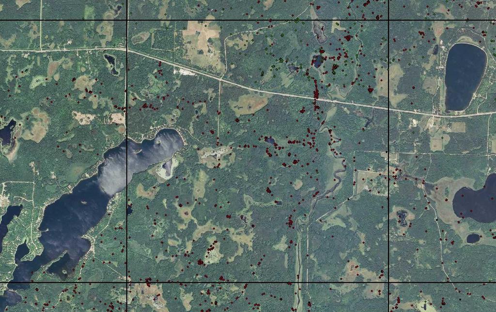
2 Research projects Population trend indices Scent-post survey Winter Track Survey Verified Depredations Population Size/Distribution Surveys every 10 years, now ; 1989; 1998; 2003; 2007

3 Gather wolf observation data from a variety of sources during 1 winter Delineate the extent of contiguous wolf range in MN Quantify how much is occupied range Estimate pack and territory size from radio-telemetry studies Calculate final population

4 Winter effort; record observations of wolf activity from November through April Use of natural resource professionals Opportunistic observations only

5 Minnesota DNR staff USFS, USFWS, USDA-WS, USGS County Land Departments Tribal/treaty natural resource staff Private forest products industry Natural resources consultants Wisconsin DNR


6 Main wolf survey USDA WS trapping data MN DNR winter track survey MN DNR scent post survey Radio-telemetry data


7 visual 16% scat 7% other 3% 2007 tracks 74% Visual 12.4% Scat 5.4% Other 4.5% visual 10% scat 5% other 2% tracks 83% Track 77.7%
8 Wolf Survey Observations (opportunistic) Human/Road Density Model Helps fill in sampling gaps Land Use / Land Cover Previous Observations Assume contiguous range

9 Township scale Township occupied if: Within total range, and: Pack detected; or Meets road/human model Roads < 0.7 km/km2 and humans < 4/km2; or Roads < 0.5 km/km2 and humans < 8/km2 Exclude lakes > 200 km 2
10 Calculate Road Density township roads and higher does not include forest roads. Township road density.shp
11 Calculate Human Density most recent US census 2000census.shp and above
12


13 Average mid-winter pack size Average territory size (MCP)
 Multiply by mean pack size (5.3 wolves) = number of pack wolves (2,567) Divide by 0.")
14 Area of total wolf range: 88,325 km² Area of occupied wolf range: 67,852 km² Adjust mean territory size (102 km² ) upwards by 37% to compensate for interstices (140 km² total) Divide occupied area by mean pack area = number of packs (485) Multiply by mean pack size (5.3 wolves) = number of pack wolves (2,567) Divide by 0.85 for single wolves in the population and add to packs = 3,020 CI obtained by bootstrapping pack/territory data
15 Comparison of Minnesota wolf surveys # field obsn s Total range (km2) 36,500 60,178 88,325 88,325 88,325 Occupied Range (km2) 36,500 53,000 73,920 67,852 71,514 # radioed packs * Ave. pack size Ave. Territory Size (km2) Estimated # packs Population Estimate ,921 ~ 90% CI +/-500 +/-700 +/-650
16 Wolf Survey Methodology Future Research Direction Sample size and geographic representation of radio-collared packs. Standardize (sample size and temporal distribution) telemetry location data used to construct territory boundaries; interstitial spaces? Consider more quantitative approaches for delineating range Can we draw on home range methodology? MCMC mapping image reconstruction Occupancy models Spatial scale of range/occupancy mapping is the township scale best? Human/road density model time to update criteria? Add or replace with forest or deer criteria? When is a road a road? Confidence interval estimation uncertainty in range delineation? New methodology??? SUPE method; Genetic mark-recap? HOW PRECISE DO WE NEED TO BE? Cost-Benefits?


17 Scent Station Survey Routes
18

19 Winter Track Survey Routes
20
21 Verified Depredations Pop Size/100 Mech - SNF 3-Year Ave. SS 3-Year Ave. WT Forest deer/mi
22 Pack Census / Territory Mapping Various detection-corrected counts Mark-recapture (tags, DNA, biomarkers, etc) Aerial Survey w/ estimate or model of detection sightability model, distance-sampling, SUPE, etc Population Reconstruction CIR, CPUE Demography / Population Modeling

23 Subdivide study area into sample blocks (e.g., 3mi X 3mi grid) Stratify blocks according to expected wolf density (high, med, low) Select subsample from each strata (e.g., 50% high, 25% med, 10% low) After fresh snowfall, survey selected blocks from aircraft When track detected, must backtrack to start, and forward to wolves Record track path, or at least all sample blocks wolves entered Record group size Assumptions: All wolves/groups detected Track paths accurate and continuous Group counts accurate Spatially and temporally completed to ensure no double-counting

24

25
26
27

28 15% sampling rate 30% sampling rate
29

30
John Erb, Carolin Humpal, and Barry Sampson, Minnesota Department of Natural Resources
 DISTRIBUTION AND ABUNDANCE OF WOLVES IN MINNESOTA, 2017-18 John Erb, Carolin Humpal, and Barry Sampson, Minnesota Department of Natural Resources At the time wolves were federally protected in the mid-1970s,
John Erb, Minnesota Department of Natural Resources, Forest Wildlife Research Group
 FURBEARER WINTER TRACK SURVEY SUMMARY, John Erb, Minnesota Department of Natural Resources, Forest Wildlife Research Group INTRODUCTION Monitoring the distribution and abundance of carnivores can be important
DISTRIBUTION AND ABUNDANCE OF WOLVES IN MINNESOTA, John Erb and Barry Sampson, Minnesota Department of Natural Resources
 DISTRIBUTION AND ABUNDANCE OF WOLVES IN MINNESOTA, 2012-13 John Erb and Barry Sampson, Minnesota Department of Natural Resources At the time wolves were federally protected in the mid-1970 s, Minnesota
PROGRESS REPORT for COOPERATIVE BOBCAT RESEARCH PROJECT. Period Covered: 1 January 31 May Prepared by
 PROGRESS REPORT for COOPERATIVE BOBCAT RESEARCH PROJECT Period Covered: 1 January 31 May 2011 Prepared by John A. Litvaitis, Derek Broman, and Marian K. Litvaitis Department of Natural Resources University
Snowtrack surveys for Canada lynx presence in Minnesota west of Highway 53
 Snowtrack surveys for Canada lynx presence in Minnesota west of Highway 53 2005 Annual Report to Minnesota Department of Natural Resources Ronald Moen, Ph.D. Gerald Niemi, Ph.D. Julie Palakovich Christopher
Lynx and Other Carnivore Surveys in Wisconsin in Winter
 Lynx and Other Carnivore Surveys in Wisconsin in Winter 2003-2004 By Adrian P. Wydeven, Jane E. Wiedenhoeft, Ronald N. Schultz and Sarah Boles Wisconsin DNR, Park Falls September 13, 2004 For: U.S. Fish
Frontier and Remote (FAR) Area Codes: A Preliminary View of Upcoming Changes John Cromartie Economic Research Service, USDA
 Area Codes: A Preliminary View of Upcoming Changes John Cromartie Economic Research Service, USDA") National Center for Frontier Communities webinar, January 27, 2015 Frontier and Remote (FAR) Area Codes: A Preliminary View of Upcoming Changes John Cromartie Economic Research Service, USDA The views
National Center for Frontier Communities webinar, January 27, 2015 Frontier and Remote (FAR) Area Codes: A Preliminary View of Upcoming Changes John Cromartie Economic Research Service, USDA The views
Moose Stratified Block Census, Management Unit 8-5, Okanagan Region, February 2005
 Moose Stratified Block Census, Management Unit 8-5, Okanagan Region, February 2005 by Les W. Gyug, R.P.Bio. Okanagan Wildlife Consulting 3130 Ensign Way Westbank, B.C. V4T 1T9 Prepared for B.C. Ministry
A Comprehensive Inventory of the Number of Modified Stream Channels in the State of Minnesota. Data, Information and Knowledge Management.
 A Comprehensive Inventory of the Number of Modified Stream Channels in the State of Minnesota Data, Information and Knowledge Management Glenn Skuta Environmental Analysis and Outcomes Division Minnesota
VCS MODULE VMD0018 METHODS TO DETERMINE STRATIFICATION
 VMD0018: Version 1.0 VCS MODULE VMD0018 METHODS TO DETERMINE STRATIFICATION Version 1.0 16 November 2012 Document Prepared by: The Earth Partners LLC. Table of Contents 1 SOURCES... 2 2 SUMMARY DESCRIPTION
2010 Wildlife Management Unit 347 moose
 2010 Wildlife Management Unit 347 moose Photo: Curtis Stambaugh Section Authors: Curtis Stambaugh and Corey Rasmussen Suggested Citation: Stambaugh, C., and C. Rasmussen. 2010. Wildlife Management Unit
2010 Wildlife Management Unit 358 moose
 2010 Wildlife Management Unit 358 moose Photo: Dave Stepnisky Section Authors: Dave Stepnisky and Robb Stavne Suggested Citation: Stepnisky, D., and R. Stavne. 2010. Wildlife Management Unit 358 moose.
2013 Aerial Moose Survey Final Results
 2013 Aerial Moose Survey Final Results Glenn D. DelGiudice, Forest Wildlife Populations and Research Group Introduction Each year, we conduct an aerial survey in northeastern Minnesota in an effort to
13.1. Ecologists Study Relationships. Ecologists study environments at different levels of organization.
 13.1 Ecologists Study Relationships VOCABULARY ecology community ecosystem biome KEY CONCEPT Ecology is the study of the relationships among organisms and their environment. Main Ideas Ecologists study
PREDICTING GRAY WOLF LANDSCAPE RECOLONIZATION: LOGISTIC REGRESSION MODELS VS. NEW FIELD DATA
 Ecological Applications, 9(1), 1999, pp. 37 44 1999 by the Ecological Society of America PREDICTING GRAY WOLF LANDSCAPE RECOLONIZATION: LOGISTIC REGRESSION MODELS VS. NEW FIELD DATA DAVID J. MLADENOFF,
An Internet-based Agricultural Land Use Trends Visualization System (AgLuT)
") An Internet-based Agricultural Land Use Trends Visualization System (AgLuT) Prepared for Missouri Department of Natural Resources Missouri Department of Conservation 07-01-2000-12-31-2001 Submitted by
An Internet-based Agricultural Land Use Trends Visualization System (AgLuT) Prepared for Missouri Department of Natural Resources Missouri Department of Conservation 07-01-2000-12-31-2001 Submitted by
Chapter 6. Fundamentals of GIS-Based Data Analysis for Decision Support. Table 6.1. Spatial Data Transformations by Geospatial Data Types
 Chapter 6 Fundamentals of GIS-Based Data Analysis for Decision Support FROM: Points Lines Polygons Fields Table 6.1. Spatial Data Transformations by Geospatial Data Types TO: Points Lines Polygons Fields
Lake Tahoe Watershed Model. Lessons Learned through the Model Development Process
 Lake Tahoe Watershed Model Lessons Learned through the Model Development Process Presentation Outline Discussion of Project Objectives Model Configuration/Special Considerations Data and Research Integration
Assessing Fishery Condition: Population Estimation
 Assessing Fishery Condition: Population Estimation Chapter 11 Thought for Today: "In God we trust, all others bring data." William Edward Deming (1900-1993). Why? Needs / Requirements Objectives Info about
Relationship between weather factors and survival of mule deer fawns in the Peace Region of British Columbia
 P E A C E R E G I O N T E C H N I C A L R E P O R T Relationship between weather factors and survival of mule deer fawns in the Peace Region of British Columbia by: Nick Baccante and Robert B. Woods Fish
StreamStats: Delivering Streamflow Information to the Public. By Kernell Ries
 StreamStats: Delivering Streamflow Information to the Public By Kernell Ries U.S. Department of the Interior U.S. Geological Survey MD-DE-DC District 410-238-4317 kries@usgs.gov StreamStats Web Application
John Laznik 273 Delaplane Ave Newark, DE (302)
") Office Address: John Laznik 273 Delaplane Ave Newark, DE 19711 (302) 831-0479 Center for Applied Demography and Survey Research College of Human Services, Education and Public Policy University of Delaware
Office Address: John Laznik 273 Delaplane Ave Newark, DE 19711 (302) 831-0479 Center for Applied Demography and Survey Research College of Human Services, Education and Public Policy University of Delaware
Monitoring tigers: Any monitoring program is a compromise between science and logistic constraints - Hutto & Young ! Vast landscape low density,
 Any monitoring program is a compromise between science and logistic constraints - Hutto & Young 2003 Monitoring tigers:! Vast landscape low density,! Cryptic species, wide ranging! Limitation of professional
TESTING FUNCTIONAL RESTORATION OF LINEAR FEATURES PHASE I PROGRESS REPORT WITHIN BOREAL CARIBOU RANGE
 TESTING FUNCTIONAL RESTORATION OF LINEAR FEATURES WITHIN BOREAL CARIBOU RANGE PHASE I PROGRESS REPORT Craig DeMars, Ph.D., Department of Biological Sciences, University of Alberta, and Alberta Biodiversity
THE NEW DNR LANDSLIDE HAZARDS PROGRAM
 THE NEW DNR LANDSLIDE HAZARDS PROGRAM Kara Jacobacci, G.I.T. Landslide Hazards Program Washington Geological Survey Washington Department of Natural Resources LEGISLATIVE FUNDING 2015 session DNR requested
Information for File # MMJ; Trunk Highway (TH) 7 / Louisiana Ave. Interchange Project
 7 / Louisiana Ave. Interchange Project") Information for File # 2013-00531-MMJ; Trunk Highway (TH) 7 / Louisiana Ave. Interchange Project Applicant: City of St. Louis Park Corps Contact: Melissa Jenny Address: U.S. Army Corps of Engineers Attn:
Information for File # 2013-00531-MMJ; Trunk Highway (TH) 7 / Louisiana Ave. Interchange Project Applicant: City of St. Louis Park Corps Contact: Melissa Jenny Address: U.S. Army Corps of Engineers Attn:
Demography and Genetic Structure of the NCDE Grizzly Bear Population. Kate Kendall US Geological Survey Libby, MT Jan 26, 2011
 Demography and Genetic Structure of the NCDE Grizzly Bear Population Kate Kendall US Geological Survey Libby, MT Jan 26, 2011 GRIZZLY BEAR RECOVERY ZONES NEED FOR INFORMATION No baseline data Cabinet -Yaak
Understanding China Census Data with GIS By Shuming Bao and Susan Haynie China Data Center, University of Michigan
 Understanding China Census Data with GIS By Shuming Bao and Susan Haynie China Data Center, University of Michigan The Census data for China provides comprehensive demographic and business information
Tracks as a non-invasive tool for monitoring large carnivores
 Tracks as a non-invasive tool for monitoring large carnivores -Manon AUTHELET 13th October 2015 Journée d étude «Gestion rationnelle et conservation de la grande faune» Forest Resources Management (GxABT/Ulg)
BIOL 217 ESTIMATING ABUNDANCE Page 1 of 10
 BIOL 217 ESTIMATING ABUNDANCE Page 1 of 10 A calculator is needed for this lab. Abundance can be expressed as population size in numbers or mass, but is better expressed as density, the number of individuals
APPLICATION OF GIS IN COMPULSORY LAND ACQUISITION PROCESS. CASE STUDY: PARTS OF KAJIADO COUNTY SECTION OF THE STANDARD GAUGE RAILWAY
 APPLICATION OF GIS IN COMPULSORY LAND ACQUISITION PROCESS. CASE STUDY: PARTS OF KAJIADO COUNTY SECTION OF THE STANDARD GAUGE RAILWAY MUSYOKA SOLOMON NTHAMA F19/1456/2010 PROJECT SUPERVISOR : J.N. MWENDA
The Future of Soil Mapping using LiDAR Technology
 The Future of Soil Mapping using LiDAR Technology Jessica Philippe Soil Scientist/GIS Specialist March 24, 2016 Natural Resources Conservation Service Helping People Help the Land Area 12-STJ covers parts
MVP WMS, George Schorr
 APPROVED JURISDICTIONAL DETERMINATION FORM U.S. Army Corps of Engineers This form should be completed by following the instructions provided in Section IV of the JD Form Instructional Guidebook. SECTION
GIS Data and Technology to Support Transportation & MPO Decision-Making & Planning. using an Eco-Logical* Approach within the Kansas City Region
 GIS Data and Technology to Support Transportation & MPO Decision-Making & Planning using an Eco-Logical* Approach within the Kansas City Region Authors (in alphabetical order): Tom Gerend, Tom Jacobs,
Sensitivity of FIA Volume Estimates to Changes in Stratum Weights and Number of Strata. Data. Methods. James A. Westfall and Michael Hoppus 1
 Sensitivity of FIA Volume Estimates to Changes in Stratum Weights and Number of Strata James A. Westfall and Michael Hoppus 1 Abstract. In the Northeast region, the USDA Forest Service Forest Inventory
International Atomic Energy Agency Learning programme: Radon gas. Module 4: Developing and Implementing a Representative Indoor Radon Survey
 International Atomic Energy Agency Learning programme: Radon gas Module 4: Developing and Implementing a Representative Indoor Radon Survey Content Scope of this module Representative radon survey aims
Palmerston North Area Traffic Model
 Palmerston North Area Traffic Model Presentation to IPWEA 7 November 2014 PNATM Presentation Overview Model Scope and type Data collected The model Forecasting inputs Applications PNCC Aims and Objectives
An Internet-Based Integrated Resource Management System (IRMS)
") An Internet-Based Integrated Resource Management System (IRMS) Third Quarter Report, Year II 4/1/2000 6/30/2000 Prepared for Missouri Department of Natural Resources Missouri Department of Conservation
An Internet-Based Integrated Resource Management System (IRMS) Third Quarter Report, Year II 4/1/2000 6/30/2000 Prepared for Missouri Department of Natural Resources Missouri Department of Conservation
Grant Opportunity Monitoring Bi-State Sage-grouse Populations in Nevada
 Grant Opportunity Monitoring Bi-State Sage-grouse Populations in Nevada Proposals are due no later than November 13, 2015. Grant proposal and any questions should be directed to: Shawn Espinosa @ sepsinosa@ndow.org.
2010 Wildlife Management Unit 347 moose
 2010 Wildlife Management Unit 347 moose Photo: Curtis Stambaugh Section Authors: Curtis Stambaugh and Corey Rasmussen Stambaugh, C., and C. Rasmussen. 2012. Wildlife Management Unit 347 moose. Pages 54-57.
MOOSE POPULATION SURVEY. Tetlin National Wildlife Refuge Game Management Unit 12, eastern Alaska
 MOOSE POPULATION SURVEY Tetlin National Wildlife Refuge Game Management Unit 12, eastern Alaska H.K. Timm, USFWS Progress Report 04-02 March 8, 2004 Gail H. Collins W. N. Johnson Henry K. Timm U. S. Fish
Approach to Field Research Data Generation and Field Logistics Part 1. Road Map 8/26/2016
 Approach to Field Research Data Generation and Field Logistics Part 1 Lecture 3 AEC 460 Road Map How we do ecology Part 1 Recap Types of data Sampling abundance and density methods Part 2 Sampling design
Chesapeake Bay Remote Sensing Pilot Executive Briefing
 Chesapeake Bay Remote Sensing Pilot Executive Briefing Introduction In his Executive Order 13506 in May 2009, President Obama stated The Chesapeake Bay is a national treasure constituting the largest estuary
2009 WMU 525 Moose. Section Authors: Nathan Carruthers and Dave Moyles
 2009 WMU 525 Moose Section Authors: Nathan Carruthers and Dave Moyles Suggested Citation: Carruthers, N. and D. Moyles. WMU 525 Moose. Pages 78 83. In: N. Webb and R. Anderson. Delegated aerial ungulate
NCTCOG Regional GIS Meeting 6-Years and Going Strong. May 15, 2018 hosted by: Tarrant County
 NCTCOG Regional GIS Meeting 6-Years and Going Strong May 15, 2018 hosted by: Tarrant County Woolpert at a Glance 1911 Founded in Dayton, Ohio 25+ Offices across the nation 800+ Global employees 25+ OFFICES
Biometrics Unit and Surveys. North Metro Area Office C West Broadway Forest Lake, Minnesota (651)
") Biometrics Unit and Surveys North Metro Area Office 5463 - C West Broadway Forest Lake, Minnesota 55025 (651) 296-5200 QUANTIFYING THE EFFECT OF HABITAT AVAILABILITY ON SPECIES DISTRIBUTIONS 1 Geert Aarts
Biometrics Unit and Surveys North Metro Area Office 5463 - C West Broadway Forest Lake, Minnesota 55025 (651) 296-5200 QUANTIFYING THE EFFECT OF HABITAT AVAILABILITY ON SPECIES DISTRIBUTIONS 1 Geert Aarts
Construction Project Data Management
 Construction Project Data Management Establishing Foundations for an Asset Database Scot Twining Project Activities Supported by GIS Cadastral Mapping Proposed Pipeline Route Selection Right Of Way Acquisition
PERCEPTION and Focus on Maps. Focus on Maps 8/29/2014. English and Dutch Maps from the 1600s and 1680 British Maps of N. Am.
 PERCEPTION English and Dutch Maps from the 600s The Nature of New York Dutch67 Prof. Anthony Grande English 67 Copyright 04 AFG 676 and 680 British Maps of N. Am. 70 and 776 4 Focus on Maps Maps are geographers
KING FAHD UNIVERSITY OF PETROLEUM & MINERALS
 KING FAHD UNIVERSITY OF PETROLEUM & MINERALS Department of City & Regional Planning Introduction To GIS (CRP 514) Identifying & Planning Public School Facility In California Using GIS Presented to Dr.
LAKE SURVEY REPORT. Fisheries Management. DOW Number: Survey ID Date: 07/31/2017. Lake Identification. Lake Location. Legal Descriptions
 Fisheries Management LAKE SURVEY REPORT Lake Name: Kroon Survey Type: Targeted Survey DOW Number: 13-0013-00 Survey ID Date: 07/31/2017 Lake Identification Alternate Lake Name: N/A Primary Lake Class ID:
APPENDIX IV MODELLING
 APPENDIX IV MODELLING Kingston Transportation Master Plan Final Report, July 2004 Appendix IV: Modelling i TABLE OF CONTENTS Page 1.0 INTRODUCTION... 1 2.0 OBJECTIVE... 1 3.0 URBAN TRANSPORTATION MODELLING
A Change Detection Analysis of Agricultural Land Use from the 1970 s to 2001 in Dane County, Wisconsin and the Relationship to Urban Growth.
 A Change Detection Analysis of Agricultural Land Use from the 1970 s to 2001 in Dane County, Wisconsin and the Relationship to Urban Growth. Travis J. Bare Department of Resource Analysis, Saint Mary s
NEW YORK DEPARTMENT OF SANITATION. Spatial Analysis of Complaints
 NEW YORK DEPARTMENT OF SANITATION Spatial Analysis of Complaints Spatial Information Design Lab Columbia University Graduate School of Architecture, Planning and Preservation November 2007 Title New York
Developing Spatial Awareness :-
 Developing Spatial Awareness :- We begin to exercise our geographic skill by examining he types of objects and features we encounter. Four different spatial objects in the real world: Point, Line, Areas
Number of Sites Where Spotted Owls Were Detected
 WILDLIFE ECOLOGY TEAM WILDLIFE HABITAT RELATIONSHIPS IN WASHINGTON AND OREGON FY2014 January 27, 2015 Title: Demographic characteristics of spotted owls in the Oregon Coast Ranges, 1990 2014. Principal
The following maps must be provided as a part of the ADA. The appropriate scale for each map should be determined at the pre application conference.
 Main Street @ Coconut Creek DRI QUESTION 9 MAPS The following maps must be provided as a part of the ADA. The appropriate scale for each map should be determined at the pre application conference. Map
Information for File MVP RMM
 Information for File MVP-2013-03320-RMM Applicant: City of St. Cloud Corps Contact: Ryan Malterud Address: 180 Fifth Street East, Suite 700, St. Paul, MN 55101 E-Mail: Ryan.M.Malterud@usace.army.mil Phone:
GIS Changing the World GIS Day November 15, 2017
 + GIS Changing the World GIS Day November 15, 2017 + Growing Up On The Farm 3 Geographic Information in DNR A 75 year history of mapping and GIS. Forest type map from 1944. State of Washington - Division
KENTUCKY HAZARD MITIGATION PLAN RISK ASSESSMENT
 KENTUCKY HAZARD MITIGATION PLAN RISK ASSESSMENT Presentation Outline Development of the 2013 State Hazard Mitigation Plan Risk Assessment Determining risk assessment scale Census Data Aggregation Levels
You can't get there from here: Mapping access to Canada's teacher education programs
 You can't get there from here: Mapping access to Canada's teacher education programs Cameron William Smith, Peter Peller Werklund School of Education, University of Calgary Context/Process Initial, exploratory
Remote Sensing Techniques for Renewable Energy Projects. Dr Stuart Clough APEM Ltd
 Remote Sensing Techniques for Renewable Energy Projects Dr Stuart Clough APEM Ltd What is Remote Sensing? The use of aerial sensors to detect and classify objects on Earth Remote sensing for ecological
Technical Memorandum #2 Future Conditions
 Technical Memorandum #2 Future Conditions To: Dan Farnsworth Transportation Planner Fargo-Moorhead Metro Council of Governments From: Rick Gunderson, PE Josh Hinds PE, PTOE Houston Engineering, Inc. Subject:
Assessment and management of at risk populations using a novel GIS based UK population database tool
 Safety and Security Engineering 203 Assessment and management of at risk populations using a novel GIS based UK population database tool H. Balmforth 1, H. McManus 1 & A. Fowler 2 1 Health and Safety Laboratory,
Chapter 1 Overview of Maps
 Chapter 1 Overview of Maps In this chapter you will learn about: Key points when working with maps General types of maps Incident specific maps Map legend and symbols Map sources A map is a navigational
TABLE 1 SSFL CHEMICAL SOIL BACKGROUND STUDY DATA QUALITY OBJECTIVES
 Problem Statement: Soil chemical concentration data for selected constituents are needed from off-site chemical background reference areas (CBRAs) to establish a regulatory-compliant, publicly-reviewed,
Improvement of the National Hydrography Dataset for US Forest Service Region 3 in Cooperation with the National Forest Service
 Improvement of the National Hydrography Dataset for US Forest Service Region 3 in Cooperation with the National Forest Service Christian L. DeCasas California State University, Northridge November 7 th,
MISSOURI LiDAR Stakeholders Meeting
 MISSOURI LiDAR Stakeholders Meeting East-West Gateway June 18, 2010 Tim Haithcoat Missouri GIO Enhanced Elevation Data What s different about it? Business requirements are changing.fast New data collection
City of Hermosa Beach Beach Access and Parking Study. Submitted by. 600 Wilshire Blvd., Suite 1050 Los Angeles, CA
 City of Hermosa Beach Beach Access and Parking Study Submitted by 600 Wilshire Blvd., Suite 1050 Los Angeles, CA 90017 213.261.3050 January 2015 TABLE OF CONTENTS Introduction to the Beach Access and Parking
PEST MONITORING Describe GIS, and design and report possum population monitoring programmes using GIS
 1 of 5 level: 5 credit: 3 planned review date: November 2007 sub-field: purpose: Pest Management This unit standard is for people involved with designing, and reporting resulting results of programmes
LUCAS: A possible scheme for a master sampling frame. J. Gallego, MARS AGRI4CAST
 LUCAS: A possible scheme for a master sampling frame. J. Gallego, MARS AGRI4CAST Area frames of square segments Square segments on a classified image 2/16 Sampling farms through points farm a farm b farm
Enhancing Louisiana s GNIS
 Enhancing Louisiana s GNIS An Outreach Effort Between USGS and the Louisiana Geographic Information Center Louisiana Remote Sensing and GIS Workshop Lafayette, LA April 28, 2010 Louisiana Geographic Information
Putative Canada Lynx (Lynx canadensis) Movements across I-70 in Colorado
 Movements across I-70 in Colorado") Putative Canada Lynx (Lynx canadensis) Movements across I-70 in Colorado INTRODUCTION March 8, 2012 Jake Ivan, Mammals Researcher Colorado Parks and Wildlife 317 W. Prospect Fort Collins, CO 80526 970-472-4310
Putative Canada Lynx (Lynx canadensis) Movements across I-70 in Colorado INTRODUCTION March 8, 2012 Jake Ivan, Mammals Researcher Colorado Parks and Wildlife 317 W. Prospect Fort Collins, CO 80526 970-472-4310
Appendix 8I. Population and Community Use Analysis. December 2010
 Appendix 8I Population and Community Use Analysis December 2010 APPENDIX 8I Population and Community Use Analysis December 2010 Prepared for: Prepared by: 20 Bay Street, Suite 901 Toronto ON M5J 2N8 In
GIS in Water Resources Fall 2018 Homework #1
 GIS in Water Resources Fall 2018 Homework #1 Goal The goal of this homework is to reinforce the lecture material on Geodesy, Map Projections and Coordinate Systems by having you identify attributes and
Avoiding Nutrient Applications During Critical Periods with a Real-time Decision Support Tool: Wisconsin s Runoff Risk Advisory Forecast (RRAF)
") Avoiding Nutrient Applications During Critical Periods with a Real-time Decision Support Tool: Wisconsin s Runoff Risk Advisory Forecast (RRAF) Dustin Goering National Weather Service 27 Feb 2015 Overview
Avoiding Nutrient Applications During Critical Periods with a Real-time Decision Support Tool: Wisconsin s Runoff Risk Advisory Forecast (RRAF) Dustin Goering National Weather Service 27 Feb 2015 Overview
COMMUNITY SERVICE AREA
 INSTITUTE FOR TRIBAL ENVIRONMENTAL PROFESSIONALS Tribal Waste and Response Assistance Program (TWRAP) Developing and Implementing a Tribal Integrated Solid Waste Management Plan April 12-14, 2016 Palm
YOPP archive: needs of the verification community
 YOPP archive: needs of the verification community B. Casati, B. Brown, T. Haiden, C. Coelho Talk Outline: P1 model and observation data P2 observation uncertainty P2 matched model and observation: time
2018 Aerial Moose Survey
 2018 Aerial Moose Survey Glenn D. DelGiudice, Forest Wildlife Populations and Research Group Introduction Each year we conduct an aerial survey in northeastern Minnesota to estimate the moose (Alces americanus)
Sampling The World. presented by: Tim Haithcoat University of Missouri Columbia
 Sampling The World presented by: Tim Haithcoat University of Missouri Columbia Compiled with materials from: Charles Parson, Bemidji State University and Timothy Nyerges, University of Washington Introduction
DRAFT RURAL-URBAN POPULATION CHANGE IN PUERTO RICO, 1990 TO 2000
 DRAFT RURAL-URBAN POPULATION CHANGE IN PUERTO RICO, 1990 TO 2000 Mei-Ling Freeman Geographic Standards and Criteria Branch Geography Division US Census Bureau For presentation at the Western Regional Science
Grizzly Bears and GIS. The conservation of grizzly bears and their habitat was recognized as an important land use objective
 Grizzly Bears and GIS Introduction: The conservation of grizzly bears and their habitat was recognized as an important land use objective in the Robson Valley LRMP. The LRMP recommended retention of unharvested
5/15/ Use of Geographic Information System (GIS) in Grazing Management Muhammad Farooq Hussain Faisal 12-Arid-604 (M.
 in Grazing Management Muhammad Farooq Hussain Faisal 12-Arid-604 (M.") 5/15/218 1 Use of Geographic Information ystem (GI) in Grazing Management Muhammad Farooq Hussain Faisal 12-Arid-64 (M.phill LM) 1 Contents History Back Ground Information Introduction of GI Who use GI?
5/15/218 1 Use of Geographic Information ystem (GI) in Grazing Management Muhammad Farooq Hussain Faisal 12-Arid-64 (M.phill LM) 1 Contents History Back Ground Information Introduction of GI Who use GI?
Quick Response Report #126 Hurricane Floyd Flood Mapping Integrating Landsat 7 TM Satellite Imagery and DEM Data
 Quick Response Report #126 Hurricane Floyd Flood Mapping Integrating Landsat 7 TM Satellite Imagery and DEM Data Jeffrey D. Colby Yong Wang Karen Mulcahy Department of Geography East Carolina University
Copernicus Overview. Major Emergency Management Conference Athlone 2017
 Copernicus Overview Major Emergency Management Conference Athlone 2017 Copernicus is a European programme implemented by the European Commission. The services address six thematic areas: land, marine,
 Boone County GIS has the right to inquire about and investigate the use of any requested products and deny access to anyone based on concerns relating to privacy, security, public health, public safety,
Regional offline land surface simulations over eastern Canada using CLASS. Diana Verseghy Climate Research Division Environment Canada
 Regional offline land surface simulations over eastern Canada using CLASS Diana Verseghy Climate Research Division Environment Canada The Canadian Land Surface Scheme (CLASS) Originally developed for the
HORIZON 2030: Land Use & Transportation November 2005
 PROJECTS Land Use An important component of the Horizon transportation planning process involved reviewing the area s comprehensive land use plans to ensure consistency between them and the longrange transportation
Hennepin GIS. Tree Planting Priority Areas - Analysis Methodology. GIS Services April 2018 GOAL:
 Hennepin GIS GIS Services April 2018 Tree Planting Priority Areas - Analysis Methodology GOAL: To create a GIS data layer that will aid Hennepin County Environment & Energy staff in determining where to
High resolution population grid for the entire United States
 High resolution population grid for the entire United States A. Dmowska, T. F. Stepinski Space Informatics Lab, Department of Geography, University of Cincinnati, Cincinnati, OH 45221-0131, USA Telephone:
Minnesota s Changing Climate: Winter Impacts
 Minnesota s Changing Climate: Winter Impacts Dr. Mark Seeley Climatologist/Meteorologist Dept of Soil, Water, and Climate University of Minnesota 15 th Annual Road Salt Symposium Minnesota Landscape Arboretum
Monitoring: Spore Trapping. Presenter John Rupe
 Monitoring: Spore Trapping Presenter John Rupe Projects Florida SBR Collection Network UF, UI, USDA-ARS Dry and rain deposition Syngenta Spore Trap Network Syngenta, UA Dry deposition Detection of SBR
Sampling. Where we re heading: Last time. What is the sample? Next week: Lecture Monday. **Lab Tuesday leaving at 11:00 instead of 1:00** Tomorrow:
 Sampling Questions Define: Sampling, statistical inference, statistical vs. biological population, accuracy, precision, bias, random sampling Why do people use sampling techniques in monitoring? How do
Presented by: Bryan Bloch GIS Specialist DNREC Division of Watershed Stewardship
 Presented by: Bryan Bloch GIS Specialist DNREC Division of Watershed Stewardship Bryan Hall, AICP Sussex County Circuit Rider Planner, Office of State Planning Coordination, OMB November 19, 2012 UD Sustainable
APPROVED JURISDICTIONAL DETERMINATION FORM U.S. Army Corps of Engineers
 APPROVED JURISDICTIONAL DETERMINATION FORM U.S. Army Corps of Engineers This form should be completed by following the instructions provided in Section IV of the JD Form Instructional Guidebook. SECTION
Basic Training Battlemind to Home Symposium. Sept
 Basic Training Battlemind to Home Symposium Sept 2017 1 What is Measuring Communities? A social indicators project which allows users to obtain military-specific information about communities strengths
Status Report: Ongoing review of O-D cellular data for the TPB modeled area
 Item #4 Status Report: Ongoing review of O-D cellular data for the TPB modeled area Presentation to the Travel Forecasting Subcommittee September 19, 2014 Ronald Milone, COG/TPB staff National Capital
A Regional Database Tracking Fire Footprint Each Year within the South Atlantic Region: Current Database Description and Future Directions
 A Regional Database Tracking Fire Footprint Each Year within the South Atlantic Region: Current Database Description and Future Directions Last Updated on September 30, 2018 Contributors: NatureServe,
Navigating with Map & Compass. Nevada County Sheriff s Search & Rescue
 Navigating with Map & Compass Nevada County Sheriff s Search & Rescue Objectives Very Practical Teach you how to go from point A to point B Go from the wilderness (real world) to a map and visa versa Agenda
Vegetation and Wildlife Habitat Mapping Study in the Upper and Middle Susitna Basin Study Plan Section 11.5
 (FERC No. 14241) Vegetation and Wildlife Habitat Mapping Study in the Upper and Middle Susitna Basin Study Plan Section 11.5 Initial Study Report Part C: Executive Summary and Section 7 Prepared for Prepared
Aerial Thermal Infrared Imaging White - tailed Deer Counts Fort Thomas, Kentucky
 Aerial Thermal Infrared Imaging White - tailed Deer Counts Fort Thomas, Kentucky Submitted to: Don Martin, MPA City Administrative Officer 130 North Fort Thomas Ave Ft Thomas, KY 41075 Via email: DMartin@FtThomas.org