|
|
|
- Gillian Freeman
- 5 years ago
- Views:
Transcription


1


2


3


4

5

6


7
8

9


10


11


12
13


14


15

16

17

18
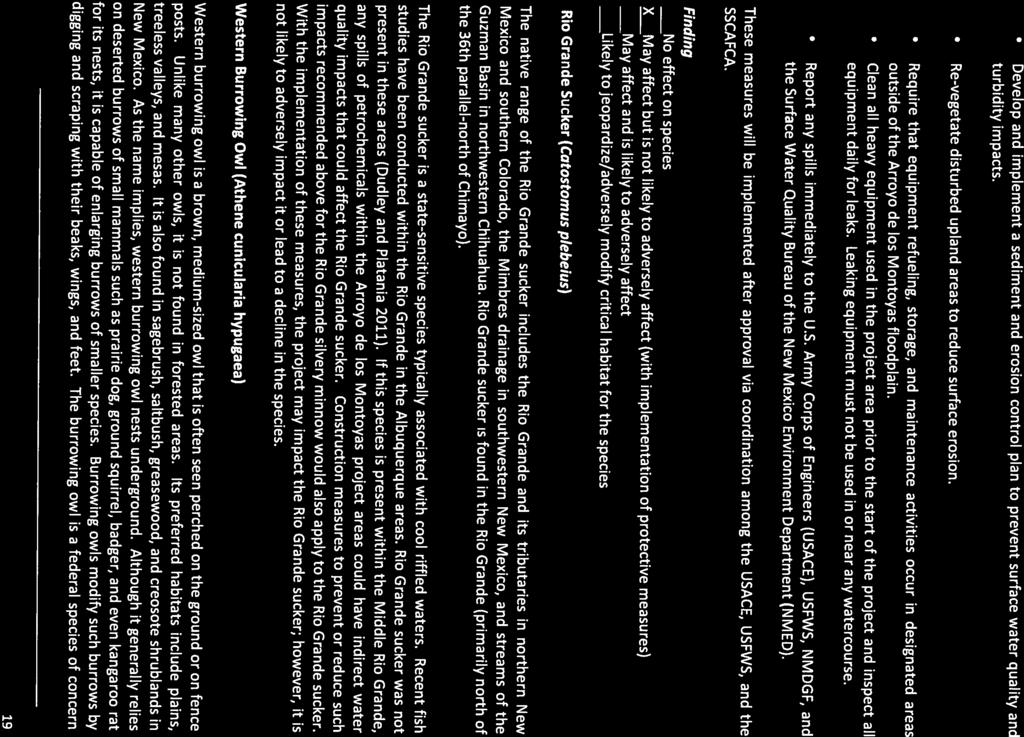
19

20
21

22
23 Appendix C Cultural Resource Survey Findings
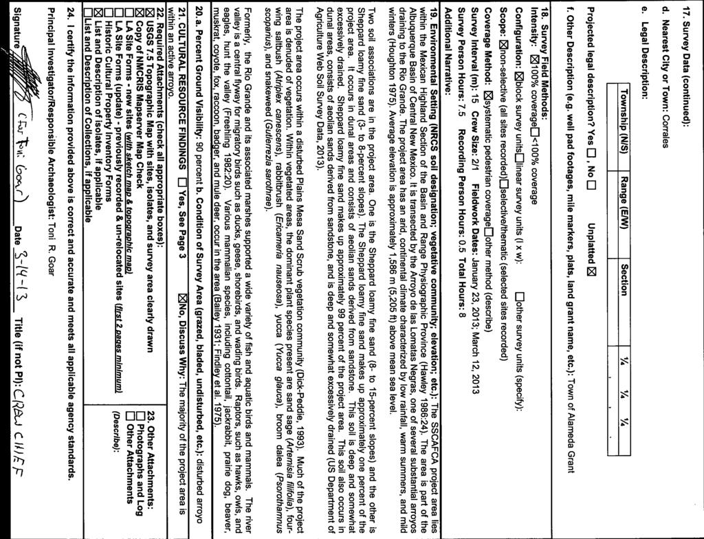
24 1. NMCRIS Activity No.: NMCRIS INVESTIGATION ABSTRACT FORM (NIAF) 2a. Lead (Sponsoring) Agency: SSCAFCA 2b. Other Permitting Agency(ies): 4. Title of Report:A Cultural Resource Survey for the Lower Montoya SSCAFCA Improvements, Sandoval County, New Mexico. 3. Lead Agency Report No.: 5. Type of Report Negative Author(s) R. Stanley Kerr 6. Investigation Type Research Design Survey/Inventory Test Excavation Excavation Collections/Non-Field Study Overview/Lit Review Monitoring Ethnographic study Site specific visit Other 7. Description of Undertaking (what does the project entail?):the Southern Sandoval County Arroyo Flood Control Authority (SSCAFCA) proposes improvements on the Arroyo de los Montoyas in Corrales, Sandoval County, New Mexico. The area surveyed was 7.12 ha (17.59 ac) in January In late February it was determined that an additional area was needed for the proposed undertaking, and Marron completed a survey on this portion in March. This portion of the project is 7.6 ha (18.77 ac), for a total of ha (36.36 ac) surveyed. The project area is within SSCAFCA right-of-way, and the Village of Corrales. Funding is likely to be federal. 10. Performing Agency/Consultant: Marron and Associates Principal Investigator: Toni R. Goar Field Supervisor: Hollis P. Lawrence, R. Stanley Kerr Field Personnel Names: Joshua Vallejos 13. Client/Customer (project proponent): NCS Engineers Contact: Mr. Stephen Jerge Address: 3188 Southern Suite A Rio Rancho, NM Phone: (505) Land Ownership Status (Must be indicated on project map): Positive 8. Dates of Investigation: (from: January 23, 2013 to: and March 12, 2013) 9. Report Date: March 14, Performing Agency/Consultant Report No.: A 12. Applicable Cultural Resource Permit No(s): NM S 14. Client/Customer Project No.: 0436A Land Owner Acres Surveyed Acres in APE SSCAFCA Village of Corrales TOTALS Records Search(es): Date(s) of ARMS File Review , Name of Reviewer(s) Darryl Del Frate Date(s) of NR/SR File Review , Name of Reviewer(s) Darryl Del Frate Date(s) of Other Agency File Review Name of Reviewer(s) Agency 17. Survey Data: a. Source Graphics NAD 27 NAD 83 USGS 7.5 (1:24,000) topo map Other topo map, Scale: GPS Unit Accuracy <1.0m 1-10m m >100m b. USGS 7.5' Topographic Map NameUSGS Quad Code Bernalillo C5 c. County(ies): Sandoval NIAF Version 1_7_25_06 1

25
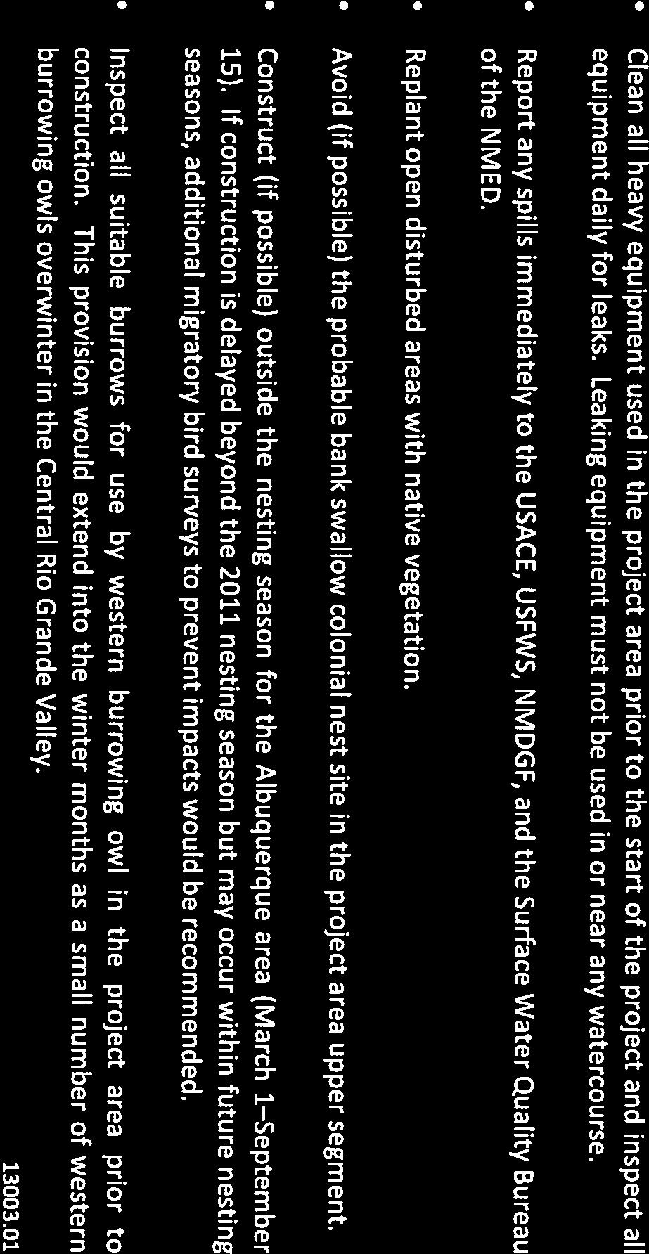
26 25. Reviewing Agency: Reviewer s Name/Date Accepted ( )Rejected () Tribal Consultation (if applicable): Yes No 26. SHPO Reviewer s Name/Date: HPD Log #: SHPO File Location: Date sent to ARMS: 1. NMCRIS Activity No.: SURVEY RESULTS: 2. Lead (Sponsoring) Agency: SSCAFCA CULTURAL RESOURCE FINDINGS [fill in appropriate section(s)] 3. Lead Agency Report No.: Sites discovered and registered: 0 Sites discovered and NOT registered: 0 Previously recorded sites revisited (site update form required): 0 Previously recorded sites not relocated(site update form required):0 TOTAL SITES VISITED: 0 Total isolates recorded: 0 Non-selective isolate recording? Total structures recorded (new and previously recorded, including acequias):0 MANAGEMENT SUMMARY:SSCAFCA is proposing to improve their flood control system on Arroyo de los Montoyas in Corrales, Sandoval County, New Mexico (Figure 1). In January, one area was surveyed and is 7.12 ha (17.59 ac). In late February, it was determined that an additional area was needed for the proposed project. This area is 7.5 ha (18.77 ac). A total of ha (36.36 ac) was surveyed for the proposed project, within SSCAFCA right-of-way and the Village of Corrales. Funding is likely to be federal. Marron and Associates conducted the survey on January 23, 2013, and March 12, Hollis P. Lawrence, R. Stanley Kerr, and Joshua Vallejos completed the survey. Eight person-hours (not including drive time) were required to complete the survey. Work was conducted under New Mexico State Permit No. NM S. The site file search indicated two previously recorded sites in the area (Figure A-1). Also, ten previous surveys were completed within 500 m (0.3 mi) of the project area (Tables 1 and 2).The previously recorded sites are outside the project area and will not be affected. Three isolated occurrences were observed within the project area (Table 3). The isolated occurrences are either flakes or a core, and all are made of chalcedony. No further treatment is recommended. This undertaking complies with the provisions of the National Historic Preservation Act (NHPA) of 1966, as amended, and applicable regulations. This report is consistent with applicable federal and state standards for cultural resource management. Table 1 Previously Recorded Sites within 0.5 km (0.3 mi) of Project Area LA No. Description Cultural Affiliation Eligibility Artifact Scatter with Features Anasazi Not entered Artifact Scatter Unknown Not entered NIAF Version 1_7_25_06 3
27 Table 2 Previous Surveys within 0.5 km (0.3 mi) of Project Area NMCRIS No. Description Acres No. of Sites Author and Date 8011 An Archaeological Survey of a Floodwater Allan, William C Retarding Structure In Corrales Watershed 8020 Letter Report: 5 Borrow and Gravel Pit Not 0 Klager, Karol 1979 Locations for the US Army Corps entered An Archaeological Survey of the State Road 528 Right of Way Nelson, Norman B Archaeological Survey of Borrow Pits A, B, C, and D on State Road Nelson, Norman B Archaeological Survey of a Proposed Effluent Line Right of Way Schmader, Matthew F Archaeological Survey of Floodwater Diversion Site No Frisbie, Theodore R A Cultural Resource Survey of the Southern Sandoval County Arroyo Flood Control Authority Outfall Pipe from Dams 1 and 4 to Los Montoyas Arroyo Allen, Christina G Cultural Resource Survey for the Proposed Interim Improvement of the Wastewater Treatment System An Archaeological Survey for the New Mexico State Highway 528 Improvement Project A Cultural Resource Survey for the Angel Road Improvement Project and the Eastern Meadowlark Lane Corrales Interior Drain Culvert Replacement Project A Cultural Resource Inventory of 5.07 Acres for the Proposed Installation of Sewer Lines and Roadway Infrastructure on Industrial Park Loop, Enterprise Road, Commerce Place, and Frontage Road A Cultural Resource Survey for the Rio Rancho Effluent Reuse System Project Fletcher, Thomas F Marshall, Michael, and Christina Marshall Marshall, Michael P Benally, Garyald S Wands, Courtney, Teresa Hurt, Nicholas Parker, Table 3 Isolated Occurrence Summary IO No. Description Location 1 1 chalcedony core, multidirectional, 9 x 7 x 6 cm Flat 2 1 chalcedony non cortical core reduction flake, 4 x 4 x 2 Dune/Terrace cm 3 1 chalcedony cortical core reduction flake, 2 x 1 x 0.5 cm Arroyo bottom NIAF Version 1_7_25_06 4
28 San Juan Mora Los Alamos Harding McKinley Sandoval San Miguel Santa Fe Quay Cibola Bernalillo Guadalupe Valencia Torrance Project Curry DeBaca Area Catron Socorro Roosevelt Lincoln Hidalgo Rio Arriba Sierra Taos Grant Otero Doña Ana Luna Colfax Chaves Eddy Union Lea Loma Machete, NM USGS 7.5' Quadrangle Bernalillo, NM USGS 7.5' Quadrangle Upper Project Area Lower Project Area Los Griegos, NM USGS 7.5' Quadrangle Alameda, NM USGS 7.5' Quadrangle MARRON andassociates Project Area Town of Alameda Grant Private Lands Sandoval County, New Mexico Figure 1 Project Area Map Miles Kilometers 1:24,000 SSCAFCA - NCS Arroyo de los Montoyas, Sandoval County, New Mexico
29 San Juan Mora Los Alamos Harding McKinley Sandoval San Miguel Santa Fe Quay Cibola Bernalillo Guadalupe Valencia Torrance Project Curry DeBaca Area Catron Socorro Roosevelt Lincoln Hidalgo Rio Arriba Sierra Taos Grant Otero Doña Ana Luna Colfax Chaves Eddy Union Lea Loma Machete, NM USGS 7.5' Quadrangle Bernalillo, NM USGS 7.5' Quadrangle LA HCPI Upper Project Area LA Lower Project Area Los Griegos, NM USGS 7.5' Quadrangle Alameda, NM USGS 7.5' Quadrangle MARRON andassociates Previously Recorded Site Previously Recorded HCPI Town of Alameda Grant Private Lands Sandoval County, New Mexico Figure A1 File Search Map ARMS Search (500 m) Project Area Previous Survey ,000 Meters 0 1,000 2,000 4,000 Feet 1:24,000 SSCAFCA - NCS Arroyo de los Montoyas, Sandoval County, New Mexico
30 San Juan Mora Los Alamos Harding McKinley Sandoval San Miguel Santa Fe Quay Cibola Bernalillo Guadalupe Valencia Torrance Project Curry DeBaca Area Catron Socorro Roosevelt Lincoln Hidalgo Rio Arriba Sierra Taos Grant Otero Doña Ana Luna Colfax Chaves Eddy Union Lea Loma Machete, NM USGS 7.5' Quadrangle Bernalillo, NM USGS 7.5' Quadrangle IO 3 IO 2 IO 1 HCPI Upper Project Area Lower Project Area Los Griegos, NM USGS 7.5' Quadrangle Alameda, NM USGS 7.5' Quadrangle MARRON andassociates Project Area Isolate Town of Alameda Grant Private Lands Sandoval County, New Mexico Figure A2 Cultural Resource Location Map Miles Kilometers 1:24,000 SSCAFCA - NCS Arroyo de los Montoyas, Sandoval County, New Mexico
 Archaeological Surveys Highways Proposed Approved Prim ary Lim ited Access or Interstate Prim ary US and State")
31 Map Site Labels Site Boundaries (Edit) Site Boundaries Proposed Approved Building Labels Buildings Proposed Approved Objects Proposed Approved Linear Resources Archaeological Surveys (Edit) Archaeological Surveys Highways Proposed Approved Prim ary Lim ited Access or Interstate Prim ary US and State Highways
32 Object Labels Linear Resource Labels Historic Structure Labels Historic Structures (Edit) Buildings (Edit) Objects (Edit) Linear Resources (Edit) Historic Structures Proposed Approved Proposed Approved District Labels Districts (Edit) Districts Proposed Approved Register Properties (Edit) Register Properties Proposed Approved Prim ary US and State Highways Secondary State and County Local - Rural Ram p, other Detailed Streets New Mexico Counties Towns NGS USA Topographic Maps NMCRIS Background Ref erence Layers DRGs: Copyright: 2010 National Geographic Society NGS USA Topographic Maps: Copyright: 2010 National Geographic Society Satellite I m agery ESRI_Im agery_world_2d: Copyright: 2009 ESRI, i-cubed, GeoEye World Im agery: Copyright: 2009 ESRI, i-cubed, GeoEye
 Archaeological Surveys Highways Proposed Approved Prim ary Lim ited Access or Interstate Prim ary US and State")
33 Map Site Labels Site Boundaries (Edit) Site Boundaries Proposed Approved Building Labels Buildings Proposed Approved Objects Proposed Approved Linear Resources Archaeological Surveys (Edit) Archaeological Surveys Highways Proposed Approved Prim ary Lim ited Access or Interstate Prim ary US and State Highways
34 Object Labels Linear Resource Labels Historic Structure Labels Historic Structures (Edit) Buildings (Edit) Objects (Edit) Linear Resources (Edit) Historic Structures Proposed Approved Proposed Approved District Labels Districts (Edit) Districts Proposed Approved Register Properties (Edit) Register Properties Proposed Approved Prim ary US and State Highways Secondary State and County Local - Rural Ram p, other Detailed Streets New Mexico Counties Towns NGS USA Topographic Maps NMCRIS Background Ref erence Layers DRGs: Copyright: 2013 National Geographic Society NGS USA Topographic Maps: Copyright: 2013 National Geographic Society NM 2009 NA I P Color A erial P hotos NAIPNew_Mexico_2011_1m _NC: APFO Satellite I m agery ESRI_Im agery_world_2d: Copyright: 2013 ESRI, i-cubed, GeoEye World Im agery: Copyright: 2013 ESRI, i-cubed, GeoEye
BKLUP PRELIMINARY SUMMARY REPORT JULY 2016
 PARTICIPATED LAST MONTH TOTAL BLKUP HOURS OTHER Alamogordo PD 2 Otero 6 0 0 0 0 0 4 3 N/P Albuquerque PD 3 Bernalillo N/P Anthony PD 1 Dona Ana 4 0 0 0 0 0 3 0 Artesia PD 2 Eddy 16 0 0 0 0 3 9 0 N/P Aztec
PW Parkway ES Prince William County, Virginia WSSI #
 PW Parkway ES Prince William County, Virginia WSSI #15.3 Cultural Resources Site Assessment November 15 Prepared for: Prince William County Public Schools P.O. Box 39 Manassas, Virginia 1 Prepared by:
Use of Kernel Density and Raster Manipulation in GIS to Predict Population in New Mexico Census Tracts
 Review of Economics & Finance Submitted on 18/04/2018 Article ID: 1923-7529-2018-04-25-14 Srini Vasan, Jack Baker, and Adélamar Alcántara Use of Kernel Density and Raster Manipulation in GIS to Predict
Appendix I-1: Archaeological Records Search
 Appendix I-1: Archaeological Records Search South Central Coastal Information Center California State University, Fullerton Department of Anthropology MH-426 800 North State College Boulevard Fullerton,
AN ARCHAEOLOGICAL SURVEY FOR THE DCP MIDSTREAM THREE RIVERS PLANT TO CGP 51 PROJECT IN LIVE OAK COUNTY, TEXAS
 AN ARCHAEOLOGICAL SURVEY FOR THE DCP MIDSTREAM THREE RIVERS PLANT TO CGP 51 PROJECT IN LIVE OAK COUNTY, TEXAS By William E. Moore Brazos Valley Research Associates Contract Report Number 251 2011 AN ARCHAEOLOGICAL
COLORADO CULTURAL RESOURCE SURVEY Management Data Form Rev. 11/10
 COLORADO CULTURAL RESOURCE SURVEY OAHP1400 Rev. 11/10 A should be completed for each cultural resource recorded during an archaeological survey. Isolated finds and revisits are the exception and they do
Cultural Resources Data
 MENIFEE VALLEY CAMPUS MASTER PLAN DRAFT EIR MT. SAN JACINTO COMMUNITY COLLEGE DISTRICT Appendices Appendix E Cultural Resources Data February 2017 MENIFEE VALLEY CAMPUS MASTER PLAN DRAFT EIR MT. SAN JACINTO
Sacred Lands File & Native American Contacts List Request
 Sacred Lands File & Native American Contacts List Request NATIVE AMERICAN HERITAGE COMMISSION 915 Capitol Mall, RM 364 Sacramento, CA 95814 (916) 653-4082 (916) 657-5390 Fax nahc@pacbell.net Information
New Mexico Register / Volume XVI, Number 15 / August 15, 2005
 TITLE 4 CHAPTER 10 PART 17 CULTURAL RESOURCES CULTURAL PROPERTIES AND HISTORIC PRESERVATION STANDARDS FOR MONITORING 4.10.17.1 ISSUING AGENCY: Cultural Properties Review Committee. Contact State Historic
4.3 CULTURAL RESOURCES
 4.3 CULTURAL RESOURCES This section of the EIR analyzes the proposed project s potential impacts on archaeological and paleontological resources. This analysis summarizes the findings of the Archaeological
NEWS RELEASE UNDER SECTION 404 OF THE CLEAN WATER ACT (33 USC 1344) ACTION NUMBER SPA ABQ
 ACTION NUMBER SPA ABQ") PUBLIC NOTICE Public Notice Issue Date: //6/07 Albuquerque District Comments due: /6/08 NEWS RELEASE UNDER SECTION 0 OF THE CLEAN WATER ACT ( USC ) ACTION NUMBER SPA-06-00-ABQ BANK STABILIZATION ALONG
PUBLIC NOTICE Public Notice Issue Date: //6/07 Albuquerque District Comments due: /6/08 NEWS RELEASE UNDER SECTION 0 OF THE CLEAN WATER ACT ( USC ) ACTION NUMBER SPA-06-00-ABQ BANK STABILIZATION ALONG
ADDITIONAL PHASE IA ARCHAEOLOGICAL SURVEY FOR THE UMORE PARK SAND AND GRAVEL MINING ENVIRONMENTAL REVIEW SERVICES, DAKOTA COUNTY, MINNESOTA
 ADDITIONAL PHASE IA ARCHAEOLOGICAL SURVEY FOR THE UMORE PARK SAND AND GRAVEL MINING ENVIRONMENTAL REVIEW SERVICES, DAKOTA COUNTY, MINNESOTA ADDENDUM I Submitted to: Short Elliot Hendrickson, Inc. Submitted
Proposed Scope of Work Village of Farmingdale Downtown Farmingdale BOA Step 2 BOA Nomination Study / Draft Generic Environmental Impact Statement
 Proposed Scope of Work Village of Farmingdale Downtown Farmingdale BOA Step 2 BOA Nomination Study / Draft Generic Environmental Impact Statement The scope of work that follows incorporates and covers
Additional Testing for Padre Dam Eastern Service Area Secondary Connection- Alternative Site Location, San Diego County, California
 Mark Niemiec Padre Dam Municipal Water District P.O. Box 719003 9300 Fanita Parkway Santee, California 92072 Re: Additional Testing for Padre Dam Eastern Service Area Secondary Connection- Alternative
National Register of Historic Places Registration Form
 United States Department of the Interior National Park Service National Register of Historic Places Registration Form This form is for use in nominating or requesting determinations for individual properties
Geospatial Data Model for Archaeology Site Data
 Authors: David T. Hansen, Barbara D. Simpson, Anastasia Leigh, Patrick Welch, and Lorri Peltz-Lewis Geospatial Data Model for Archaeology Site Data Presented by David T. Hansen and Barbara D. Simpson at
Historic Cultural Properties Inventory (HCPI) Base Form (FORM 1)
 Base Form (FORM 1)") Historic Cultural Properties Inventory (HCPI) Base Form (FORM 1) Historic Preservation Division, New Mexico Office of Cultural Affairs For HPD Office use only: HCPI No. District No. NRHP: SRCP: Criteria:
Historic Cultural Properties Inventory (HCPI) Base Form (FORM 1) Historic Preservation Division, New Mexico Office of Cultural Affairs For HPD Office use only: HCPI No. District No. NRHP: SRCP: Criteria:
Attached you will find files containing information on the sites and surveys we have in our database for the location you requested.
 Attached you will find files containing information on the sites and surveys we have in our database for the location you requested. These files include Microsoft Office Excel spreadsheets with database
AN ARCHAEOLOGICAL SURVEY FOR THE EASTHAM STATE PRISON FARM UNIT PROJECT IN HOUSTON COUNTY TEXAS
 AN ARCHAEOLOGICAL SURVEY FOR THE EASTHAM STATE PRISON FARM UNIT PROJECT IN HOUSTON COUNTY TEXAS Antiquities Permit 5693 By William E. Moore and Edward P. Baxter Brazos Valley Research Associates Contract
Information for File # MMJ; Trunk Highway (TH) 7 / Louisiana Ave. Interchange Project
 7 / Louisiana Ave. Interchange Project") Information for File # 2013-00531-MMJ; Trunk Highway (TH) 7 / Louisiana Ave. Interchange Project Applicant: City of St. Louis Park Corps Contact: Melissa Jenny Address: U.S. Army Corps of Engineers Attn:
Information for File # 2013-00531-MMJ; Trunk Highway (TH) 7 / Louisiana Ave. Interchange Project Applicant: City of St. Louis Park Corps Contact: Melissa Jenny Address: U.S. Army Corps of Engineers Attn:
Historic Cultural Properties Inventory (HCPI) Base Form (FORM 1)
 Base Form (FORM 1)") Historic Cultural Properties Inventory (HCPI) Base Form (FORM 1) Historic Preservation Division, New Mexico Office of Cultural Affairs For HPD Office use only: HCPI No. District No. NRHP: SRCP: Criteria:
Historic Cultural Properties Inventory (HCPI) Base Form (FORM 1) Historic Preservation Division, New Mexico Office of Cultural Affairs For HPD Office use only: HCPI No. District No. NRHP: SRCP: Criteria:
Uniform Sign Plan (USP) Travis Park 89-USP-007
 Travis Park 89-USP-007") Uniform Sign Plan (USP) Travis Park 89-USP-007 These guidelines are published for informational purposes. A sign permit application must be submitted and a permit issued prior to installation of a sign.
Uniform Sign Plan (USP) Travis Park 89-USP-007 These guidelines are published for informational purposes. A sign permit application must be submitted and a permit issued prior to installation of a sign.
A. My name is Watsun Randolph and my business address is 45 Horner Street Warrenton
 DIRECT TESTIMONY OF WATSUN RANDOLPH ON BEHALF OF PIEDMONT ENVIRONMENTAL COUNCIL BEFORE THE STATE CORPORATION COMMISSION OF VIRGINIA CASE NOS. PUE-00-000 AND PUE-00-000 0 Q. PLEASE STATE YOUR NAME AND BUSINESS
Historic Cultural Properties Inventory (HCPI) Base Form (FORM 1)
 Base Form (FORM 1)") Historic Cultural Properties Inventory (HCPI) Base Form (FORM 1) Historic Preservation Division, New Mexico Office of Cultural Affairs For HPD Office use only: HCPI No. District No. NRHP: SRCP: Criteria:
Historic Cultural Properties Inventory (HCPI) Base Form (FORM 1) Historic Preservation Division, New Mexico Office of Cultural Affairs For HPD Office use only: HCPI No. District No. NRHP: SRCP: Criteria:
D Yes ~ No D To Be Determined
 Project Development and Environmental Analysis Branch Project Data Sheets TIP No.: R-5858 Sent Date: Oct. 8 th 2017 WBS No.: 475546.1.1 Revision Date: Federal Aid No: Meeting Date: Nov. 7 th 2017 Division:
MVP WMS, George Schorr
 APPROVED JURISDICTIONAL DETERMINATION FORM U.S. Army Corps of Engineers This form should be completed by following the instructions provided in Section IV of the JD Form Instructional Guidebook. SECTION
Current Functions (Enter categories from instructions) Materials (Enter categories from instructions)
 Materials (Enter categories from instructions)") Site Inventory Form State Inventory No. 92-00490 New Supplemental State Historical Society of Iowa Part of a district with known boundaries (enter inventory no.) 92-00349 (November 2005) Relationship:
Site Inventory Form State Inventory No. 92-00490 New Supplemental State Historical Society of Iowa Part of a district with known boundaries (enter inventory no.) 92-00349 (November 2005) Relationship:
Community Discovery Data Questionnaire
 Region III Community Discovery Data Questionnaire Thank you for taking the time to complete this questionnaire. It will provide important information to help FEMA understand flood risk issues in the Conococheague-Opequon
Census Geography, Geographic Standards, and Geographic Information
 Census Geography, Geographic Standards, and Geographic Information Michael Ratcliffe Geography Division US Census Bureau New Mexico State Data Center Data Users Conference November 19, 2015 Today s Presentation
UPPER COSUMNES RIVER FLOOD MAPPING
 UPPER COSUMNES RIVER FLOOD MAPPING DRAFT BASIC DATA NARRATIVE FLOOD INSURANCE STUDY SACRAMENTO COUTY, CALIFORNIA Community No. 060262 November 2008 Prepared By: CIVIL ENGINEERING SOLUTIONS, INC. 1325 Howe
Historic Cultural Properties Inventory (HCPI) Base Form (FORM 1)
 Base Form (FORM 1)") Historic Cultural Properties Inventory (HCPI) Base Form (FORM 1) Historic Preservation Division, New Mexico Office of Cultural Affairs For HPD Office use only: HCPI No. District No. NRHP: SRCP: Criteria:
Historic Cultural Properties Inventory (HCPI) Base Form (FORM 1) Historic Preservation Division, New Mexico Office of Cultural Affairs For HPD Office use only: HCPI No. District No. NRHP: SRCP: Criteria:
Villages at Riverdale Thornton, CO
 FINAL UTILITY REPORT Villages at Riverdale Thornton, CO October 14, 216 Revised: March 29, 217 JN: 1539 Prepared for: PCS Group, Inc. 11 16 th Street #3 B-18 Denver, CO 8265 P: 33.531.495 Prepared by:
Electronic Submission Format Guide Anthracite Preparation Plant Permit Application
 Electronic Submission Format Guide Anthracite Preparation Plant Permit Application Module 1: Application Section A through Section J, the Application Checklist, and all narrative responses Act 67 / 68
DISTRICTS, MINES, AND GEOCHEMISTRY DATABASES IN NEW MEXICO. Virginia T. McLemore and Maureen Wilks
 DISTRICTS, MINES, AND GEOCHEMISTRY DATABASES IN NEW MEXICO Virginia T. McLemore and Maureen Wilks ACKNOWLEDGEMENTS New Mexico Energy, Minerals and Natural Resource Department Company annual reports Personal
Archaeological Survey and Evaluation at 8954 El Dorado Parkway, El Cajon, San Diego County, California
 April 16, 2013 Ms. Andrea Bitterling Helix Environmental Planning, Inc. 7578 El Cajon Blvd., Suite 200 El Cajon, California 91942 Re: Archaeological Survey and Evaluation at 8954 El Dorado Parkway, El
Louisiana Transportation Engineering Conference. Monday, February 12, 2007
 Louisiana Transportation Engineering Conference Monday, February 12, 2007 Agenda Project Background Goal of EIS Why Use GIS? What is GIS? How used on this Project Other site selection tools I-69 Corridor
Appendix C. Questionnaire Summary of Responses Geographic Information Systems
 Appendix C Questionnaire Summary of Responses Geographic Information Systems 1. Is your agency using or planning use of GIS for: a. general mapping (e.g. highway routes, political boundaries, etc.) b.
Swarm and Evolutionary Computation. A new PSO-optimized geometry of spatial and spatio-temporal scan statistics for disease outbreak detection
 Swarm and Evolutionary Computation 4 (2012) 1 11 Contents lists available at SciVerse ScienceDirect Swarm and Evolutionary Computation journal homepage: www.elsevier.com/locate/swevo Regular paper A new
SAN FRANCISCO DISTRICT INFORMATION REQUESTED FOR VERIFICATION OF CORPS JURISDICTION
 DEPARTMENT OF THE ARMY SAN FRANCISCO DISTRICT, U.S. ARMY CORPS OF ENGINEERS 1455 MARKET STREET SAN FRANCISCO, CALIFORNIA 94103-1398 SAN FRANCISCO DISTRICT INFORMATION REQUESTED FOR VERIFICATION OF CORPS
LOCATED IN INDIAN RIVER COUNTY PREPARED FOR S.J.R.W.M.D. AND F.W.C.D. DECEMBER, 2003 Updated 2007 Updated May 2014 PREPARED BY
 FELLSMERE WATER CONTROL DISTRICT EAST MASTER DRAINAGE PLAN AND STORMWATER HYDROLOGIC ANALYSIS OF THE GRAVITY DRAINAGE SYSTEM LOCATED BETWEEN THE EAST BOUNDARY, LATERAL U, THE MAIN CANAL, AND DITCH 24 LOCATED
If you aren t familiar with Geographical Information Systems (GIS), you. GIS, when combined with a database that stores response information,
, you. GIS, when combined with a database that stores response information,") Geographical Information Systems in EMS By William E. Ott If you aren t familiar with Geographical Information Systems (GIS), you should take a look at what GIS can offer you as an EMS manager. GIS, when
Geographical Information Systems in EMS By William E. Ott If you aren t familiar with Geographical Information Systems (GIS), you should take a look at what GIS can offer you as an EMS manager. GIS, when
APPROVED JURISDICTIONAL DETERMINATION FORM U.S. Army Corps of Engineers
 APPROVED JURISDICTIONAL DETERMINATION FORM U.S. Army Corps of Engineers This form should be completed by following the instructions provided in Section IV of the JD Form Instructional Guidebook. SECTION
Electronic Submission Format Guide Large Noncoal (Industrial Minerals) Mine Permit Application (5600-PM-BMP0315)
 Mine Permit Application (5600-PM-BMP0315)") Electronic Submission Format Guide Large Noncoal (Industrial Minerals) Mine Permit Application (5600-PM-BMP0315) Module 1: Application Section A through Section I, the Application Checklist, and all narrative
Electronic Submission Format Guide Large Noncoal (Industrial Minerals) Mine Permit Application (5600-PM-BMP0315) Module 1: Application Section A through Section I, the Application Checklist, and all narrative
New Mexico Register / Volume XVI, Number 15 / August 15, 2005
 TITLE 4 CHAPTER 10 PART 15 CULTURAL RESOURCES CULTURAL PROPERTIES AND HISTORIC PRESERVATION STANDARDS FOR SURVEY AND INVENTORY 4.10.15.1 ISSUING AGENCY: Cultural Properties Review Committee. Contact State
UTILITY REPORT FOR THORNTON SELF STORAGE THORNTON, COLORADO
 UTILITY REPORT FOR THORNTON SELF STORAGE THORNTON, COLORADO Prepared by: Bowman Consulting 63 Park Point Dr. Suite 1 Golden, CO 841 (33)-81-29 June 29, 215 Revised August 14, 215 Revised September 3, 215
Electronic Submission Format Guide Bituminous Coal Surface Mine Permit Application (5600-PM-BMP0311)
") Electronic Submission Format Guide Bituminous Coal Surface Mine Permit Application (5600-PM-BMP0311) Module 1: Application Section A through Section J, the Application Checklist, and all narrative responses.
Electronic Submission Format Guide Bituminous Coal Surface Mine Permit Application (5600-PM-BMP0311) Module 1: Application Section A through Section J, the Application Checklist, and all narrative responses.
Discovery Data Questionnaire
 Region III Discovery Data Questionnaire Thank you for taking the time to complete this Discovery Data questionnaire. It will provide important information to help FEMA better understand flood risk issues
ACTON COMMUNITY WIDE ARCHAEOLOGICAL RECONNAISSANCE SURVEY. Town of Acton and PAL, Inc.
 ACTON COMMUNITY WIDE ARCHAEOLOGICAL RECONNAISSANCE SURVEY Town of Acton and PAL, Inc. Objectives and Scope of Work Four phase study; (1. research, 2. draft report outline, resource protection bylaw, 3.
Allen Reservoir Failure Analysis Docs
 Allen Reservoir Failure Analysis Docs Don Lancaster Synergetics, Box 809, Thatcher, AZ 85552 copyright c2010 pub 10/10 as GuruGram #113 http://www.tinaja.com don@tinaja.com (928) 428-4073 There is a spectacularly
Long Term Plan What is planned for Murchison?
 Long Term Plan 2018-2028 What is planned for Murchison? 1.0 Introduction The following information provides an overview of significant projects Council has planned for the Murchison settlement in the Long
[LLAZC03000.L EA0000 LVRCA13SA A, AZ SRP Notice of Temporary Closures of Public Lands in La Paz County, AZ
 This document is scheduled to be published in the Federal Register on 01/15/2013 and available online at http://federalregister.gov/a/2013-00542, and on FDsys.gov 4310-32-P DEPARTMENT OF THE INTERIOR Bureau
THE TRINITY RIVER VISION/ GATEWAY PARK / PANTHER ISLAND
 Quarterly Project Status Report May 2018 THE TRINITY RIVER VISION/ GATEWAY PARK / PANTHER ISLAND Flood Control Project Update Construction of North Main Street Bridge by TxDOT s bridge contractor, Texas
StreamStats: Delivering Streamflow Information to the Public. By Kernell Ries
 StreamStats: Delivering Streamflow Information to the Public By Kernell Ries U.S. Department of the Interior U.S. Geological Survey MD-DE-DC District 410-238-4317 kries@usgs.gov StreamStats Web Application
REPORT OF PHYSICAL EXPLORATION AND DEVELOPMENT Section 15 - Mineral Tenure Act Regulation
 1. EVENT NUMBER(S) 1234567 4. RECORDED HOLDER Doe 123 Main Street REPORT OF PHYSICAL EXPLORATION AND DEVELOPMENT Section 15 - Mineral Tenure Act Regulation Mineral Titles and Policy Branch Ministry of
NC Streambed Mapping Project Issue Paper
 ISSUE 1: The Western North Carolina Drainage Area Requirement Issue Several inquiries and discussions in regard to the determination of the 6-acre drainage area requirement as the upstream limit have been
SURFACE GEOLOGY AND LIQUEFACTION SUSCEPTIBILITY IN THE INNER RIO GRANDE VALLEY NEAR ALBUQUERQUE, NEW MEXICO
 SURFACE GEOLOGY AND LIQUEFACTION SUSCEPTIBILITY IN THE INNER RIO GRANDE VALLEY NEAR ALBUQUERQUE, NEW MEXICO Keith I. Kelson, Christopher S. Hitchcock, and Carolyn E. Randolph William Lettis & Associates,
E Geographic Information System. Created By: Freda Rocker Pearl River County Mapping
 E-9-1-1 Geographic Information System Created By: Freda Rocker Pearl River County Mapping frocker@pearlrivercounty.net Overview of Pearl River County E-9-1-1 Communications District GIS In 1998 the Pearl
Environmental Analysis, Chapter 4 Consequences, and Mitigation
 Environmental Analysis, Chapter 4 4.17 Environmental Justice This section summarizes the potential impacts described in Chapter 3, Transportation Impacts and Mitigation, and other sections of Chapter 4,
MAPS AND THEIR CLASSIFICATION
 MAPPING MAPS AND THEIR CLASSIFICATION WHAT IS A MAP? A map is representation of the Earth's surface, showing how things are related to each other by distance, direction, and size. Maps are a way of showing
GIS and Forest Engineering Applications FE 257 Lecture and laboratory, 3 credits
 GIS and Forest Engineering Applications FE 257 Lecture and laboratory, 3 credits Instructor: Michael Wing Associate Professor Forest Engineering, Resources, and Management Oregon State University Crop
Name of Applicant Mailing Address address Telephone Number
 District Court, Water Division, Colorado Court Address: CONCERNING THE APPLICATION FOR WATER RIGHTS OF Applicant: In the River or its Tributaries In COUNTY Attorney or Party Without Attorney (Name and
Pequabuck River Flooding Study and Flood Mitigation Plan The City of Bristol and Towns of Plainville and Plymouth, CT
 Pequabuck River Flooding Study and Flood Mitigation Plan The City of Bristol and Towns of Plainville and Plymouth, CT Raymond Rogozinski and Maged Aboelata The City of Bristol and Towns of Plainville and
The 3D Elevation Program: Overview. Jason Stoker USGS National Geospatial Program ESRI 2015 UC
 + The 3D Elevation Program: Overview Jason Stoker USGS National Geospatial Program ESRI 2015 UC + 2 A little history USGS has a long, proud tradition of mapmaking (2009) + 3 The changing times Mapping
APPROVED JURISDICTIONAL DETERMINATION FORM U.S. Army Corps of Engineers
 APPROVED JURISDICTIONAL DETERMINATION FORM U.S. Army Corps of Engineers This form should be completed by following the instructions provided in Section IV of the JD Form Instructional Guidebook. SECTION
PPT Slide. Slide 1 of 32. Notes:
 Slide 1 of 32 This presentaion will describe the background of establishing an agricultural district in Westchester County and how GIS was used to map the district. file:///volumes/web/www/ce/conferences/gis%20present/testfarm/sld001.htm[4/6/11
APPLICATION FOR CONDITIONAL ABSOLUTE WATER STORAGE RIGHT
 District Court, Water Division, Colorado Court Address: CONCERNING THE APPLICATION FOR WATER RIGHTS OF Applicant: In the River or its Tributaries In COUNTY Attorney or Party Without Attorney (Name and
THE TRINITY RIVER VISION/ GATEWAY PARK / PANTHER ISLAND Flood Control Project Update
 Quarterly Project Status Report September 2018 THE TRINITY RIVER VISION/ GATEWAY PARK / PANTHER ISLAND Flood Control Project Update TxDot s contractor has nearly completed the superstructure false work
Locational business intelligence in the U.S. Forest Service: Geospatial Accomplishment Reporting ESRI USER CONFERENCE 2015 JULY 21, 2015
 Locational business intelligence in the U.S. Forest Service: Geospatial Accomplishment Reporting ESRI USER CONFERENCE 2015 JULY 21, 2015 Agenda Introduction to the US Forest Service Why geo-enable Performance
 Boone County GIS has the right to inquire about and investigate the use of any requested products and deny access to anyone based on concerns relating to privacy, security, public health, public safety,
Lab Topographic Maps. Name: Partner: Purpose. Background Information
 Lab Topographic Maps Name: Partner: Purpose The purpose of this lab is to familiarize you with graphic representations of the Earth s surface primarily maps. Simple line maps show the spatial relationship
CA Historical Resources Inventory Listing
 Appendix F Cultural CA Historical Resources Inventory Listing City Street Address Status Eval Date Resource Name Build Date Zip County APN Prop Number Prog Ref Number Primary Number OHP Program Code Van
Internet GIS Sites. 2 OakMapper webgis Application
 Internet GIS Sites # Name URL Description 1 City of Sugar Land http://www.sugarlandtx.gov/index.htm It is a city in Texas with 65,000 Residents. The City of Sugar Land, Texas, provides ArcIMS-based maps
IV. ENVIRONMENTAL IMPACT ANALYSIS E. GEOLOGY AND SOILS
 IV. ENVIRONMENTAL IMPACT ANALYSIS E. GEOLOGY AND SOILS The following section is a summary of the geotechnical report conducted for the Proposed Project. The Geotechnical Engineering Investigation (the
MCEWEN MINING ANNOUNCES EXPLORATION UPDATE FOR EL GALLO 1, MEXICO
 MCEWEN MINING ANNOUNCES EXPLORATION UPDATE FOR EL GALLO 1, MEXICO TORONTO, ONTARIO - (April 21, 2015) - McEwen Mining Inc. (NYSE: MUX) (TSX: MUX) is pleased to announce drill results that we expect will
SITE SUMMARY REPORT Candor Dump NONCD Montgomery County
 SITE SUMMARY REPORT Candor Dump NONCD 0000433 Montgomery County Senate Bill 1492 State of North Carolina State Contract N06009S Schnabel Project No. 06210002.23 February 23, 2010 Prepared for: North Carolina
Creating A-16 Compliant National Data Theme for Cultural Resources
 Creating A-16 Compliant National Data Theme for Cultural Resources Cultural Resource GIS Facility National Park Service John J. Knoerl Deidre McCarthy Paper 169 Abstract OMB Circular A-16 defines a set
APPROVED JURISDICTIONAL DETERMINATION FORM U.S. Army Corps of Engineers
 APPROVED JURISDICTIONAL DETERMINATION FORM U.S. Army Corps of Engineers This form should be completed by following the instructions provided in Section IV of the JD Form Instructional Guidebook. SECTION
Predictive Model for Archaeological Resources. Marine Corps Base Quantico, Virginia John Haynes Jesse Bellavance
 Predictive Model for Archaeological Resources Marine Corps Base Quantico, Virginia John Haynes Jesse Bellavance Report Documentation Page Form Approved OMB No. 0704-0188 Public reporting burden for the
Pierce Cedar Creek Institute GIS Development Final Report. Grand Valley State University
 Pierce Cedar Creek Institute GIS Development Final Report Grand Valley State University Major Goals of Project The two primary goals of the project were to provide Matt VanPortfliet, GVSU student, the
Archaeological Monitoring of Construction of a Six-Inch Force Main Sewer over Lookout Creek, Chattanooga, Hamilton County, Tennessee
 A Report Prepared for Hamilton County Engineering Department 300 Newell Tower 117 East Seventh Street Chattanooga, Tennessee 37402 Archaeological Monitoring of Construction of a Six-Inch Force Main Sewer
Town of Taos Request for Proposal Historic Preservation GIS Geodatabase Project April 2007
 Town of Taos Request for Proposal Historic Preservation GIS Geodatabase Project April 2007 1. Background The Town of Taos is requesting proposals from qualified firms or a team of firms who can develop
MISSOURI DEPARTMENT OF NATURAL RESOURCES MISSOURI STATE HISTORIC PRESERVATION OFFICE (SHPO) ARCHAEOLOGICAL SITE RECORDATION
 ARCHAEOLOGICAL SITE RECORDATION") MISSOURI DEPARTMENT OF NATURAL RESOURCES MISSOURI STATE HISTORIC PRESERVATION OFFICE (SHPO) ARCHAEOLOGICAL SITE RECORDATION 1. COUNTY 2. SHPO SITE NUMBER 3. LOCAL NAME / NUMBER 4. SECTION / LAND GRANT
MISSOURI DEPARTMENT OF NATURAL RESOURCES MISSOURI STATE HISTORIC PRESERVATION OFFICE (SHPO) ARCHAEOLOGICAL SITE RECORDATION 1. COUNTY 2. SHPO SITE NUMBER 3. LOCAL NAME / NUMBER 4. SECTION / LAND GRANT
North Carolina Simplified Inundation Maps For Emergency Action Plans December 2010; revised September 2014; revised April 2015
 North Carolina Simplified Inundation Maps For Emergency Action Plans December 2010; revised September 2014; revised April 2015 INTRODUCTION Emergency Action Plans (EAPs) are critical to reducing the risks
APPROVED JURISDICTIONAL DETERMINATION FORM U.S. Army Corps of Engineers
 APPROVED JURISDICTIONAL DETERMINATION FORM U.S. Army Corps of Engineers This form should be completed by following the instructions provided in Section IV of the JD Form Instructional Guidebook. SECTION
APPLICATION FOR CHANGE OF WATER RIGHT
 District Court, Water Division, Colorado Court Address: CONCERNING THE APPLICATION FOR WATER RIGHTS OF Applicant: In the River or its Tributaries In COUNTY COURT USE ONLY Attorney or Party Without Attorney
High Speed / Commuter Rail Suitability Analysis For Central And Southern Arizona
 High Speed / Commuter Rail Suitability Analysis For Central And Southern Arizona Item Type Reports (Electronic) Authors Deveney, Matthew R. Publisher The University of Arizona. Rights Copyright is held
New Mexico Public Education Department. 7th Grade Social Studies End-of-Course (EoC) Exam
 Exam") New Mexico Public Education Department Assessment Blueprint 7th Grade Social Studies End-of-Course (EoC) Exam Version 001 Spring 2015 Purpose Statement 7th Grade Social Studies The 7 th Grade Social Studies
New Mexico Public Education Department Assessment Blueprint 7th Grade Social Studies End-of-Course (EoC) Exam Version 001 Spring 2015 Purpose Statement 7th Grade Social Studies The 7 th Grade Social Studies
ch02.pdf chap2.pdf chap02.pdf
 Introduction to Geographic Information Systems 8th Edition Karl Solutions Manual Full Download: http://testbanklive.com/download/introduction-to-geographic-information-systems-8th-edition-karl-solutions-manu
Supplemental Historic Resources Survey Report Industrial Zone Properties in the Wilmington-Harbor City Community Plan Area
 Supplemental Historic Resources Survey Report Industrial Zone Properties in the Wilmington-Harbor City Community Plan Area Prepared for: City of Los Angeles Department of City Planning Office of Historic
IN THE UNITED STATES DISTRICT COURT FOR THE DISTRICT OF COLUMBIA DECLARATION OF TIM MENTZ, SR. IN SUPPORT OF MOTION FOR TEMPORARY RESTRAINING ORDER
 IN THE UNITED STATES DISTRICT COURT FOR THE DISTRICT OF COLUMBIA STANDING ROCK SIOUX TRIBE, Plaintiff, Case No. 1:16-cv-1534-JEB v. U.S. ARMY CORPS OF ENGINEERS, Defendant. DECLARATION OF TIM MENTZ, SR.
Business Office; Multiple Family Dwelling House; Parsonage; Single Family Dwelling House
 Inventory No: Historic Name: HRV.28 Unitarian Church Parsonage Common Name: Address: 5 Littleton Rd City/Town: Village/Neighborhood: Center Local No: 17D-16; 233 Year Constructed: C 1850 Architect(s):
BUNCOMBE COUNTY NORTH CAROLINA
 PROJECT SITE ² 0 0. 75 1. 5 LOCATION MAP MARCH 2018 2. 25 3 Mil es AID: PROJECT # 2018-01122 18.05301 Sheet 1 of 7 Sources: Esri, HERE, DeLorme, USGS, Intermap, INCREMENT P, NRCan, Esri Japan, METI, Esri
Commonwealth of Massachusetts Massachusetts Historical Commission 220 Morrissey Boulevard, Boston, Massachusetts
 Inventory No: Historic Name: HRV.102 Shaker Tailor Shop Common Name: Address: 88 Shaker Rd City/Town: Village/Neighborhood: Harvard Shaker Village Local No: 5-22; 9; 93; 5-E Year Constructed: Architect(s):
December 13, Kirk Shields Green Mountain Power 163 Acorn Lane Colchester, VT 05446
 December 13, 2017 Kirk Shields Green Mountain Power 163 Acorn Lane Colchester, VT 05446 RE: End of Field Letter for Archaeological Phase II Site Evaluation at Site VT-CH-1218 within the Proposed Milton
APPENDIX I: Traffic Forecasting Model and Assumptions
 APPENDIX I: Traffic Forecasting Model and Assumptions Appendix I reports on the assumptions and traffic model specifications that were developed to support the Reaffirmation of the 2040 Long Range Plan.
/O/U / 013 om NO
 k s ~ i m (Rev. 886) 10900 l\l e L C S ~ /O/U / 013 om NO. 10240018 'Jnited States Department of the Interfor National Park Service NATIONAL REGISTER OF HISTORIC PIACES REGISTRATION FORM B=b 1. Name of
Spatial Analysis with ArcGIS Pro STUDENT EDITION
 Spatial Analysis with ArcGIS Pro STUDENT EDITION Copyright 2018 Esri All rights reserved. Course version 2.0. Version release date November 2018. Printed in the United States of America. The information
Market Street PDP. Nassau County, Florida. Transportation Impact Analysis. VHB/Vanasse Hangen Brustlin, Inc. Nassau County Growth Management
 Transportation Impact Analysis Market Street PDP Nassau County, Florida Submitted to Nassau County Growth Management Prepared for TerraPointe Services, Inc. Prepared by VHB/Vanasse Hangen Brustlin, Inc.
CITY OF PORTLAND, TEXAS SERVICE PLAN FOR ANNEXATION AREA
 CITY OF PORTLAND, TEXAS SERVICE PLAN FOR ANNEXATION AREA Location and Acreage Approximately 1,863 acres of land in San Patricio County, located in the ETJ northwest of the existing City Limits. Metes and
GeoWEPP Tutorial Appendix
 GeoWEPP Tutorial Appendix Chris S. Renschler University at Buffalo - The State University of New York Department of Geography, 116 Wilkeson Quad Buffalo, New York 14261, USA Prepared for use at the WEPP/GeoWEPP