Overview of the Czech national datasets for new database
|
|
|
- Kerrie Thomasina Watson
- 5 years ago
- Views:
Transcription

1 Overview of the Czech national datasets for new database J.Kozák, V. Penížek, T. Zádorová R. Vašát, A. Rubešová Czech University of Life Sciences Prague
 Spatial+atribute database, classification CZ+WRB CZ SOTER 1:250 000 Full cover Digital (vector)+raster Modified SOTER methodology (Němeček et al.)")
2 Soil information resources Soil geodatabase 1:1M Full cover Digital (vector) Spatial+atribute database, classification CZ+WRB Soil geodatabase 1: Full cover Digital (vector) Spatial+atribute database, classification CZ+WRB CZ SOTER 1: Full cover Digital (vector)+raster Modified SOTER methodology (Němeček et al.)
 classification CZ Soil map")

3 Soil map 1: Most of the country Analog/Digital (vector) classification CZ Soil map 1: Full cover (agriculture land only) Analog Extensive set of soil profiles (tens of thousands),classification CZ
4 Update of 1:250k soil geodatabase Updated geodatabase 1:250k Aim: Connection of extended point analytical database to the existing 1:250k map Database update (time scale) Landuse incorporation Development of grid form with quantitative data (development towards GSM) Effort: statistical processing of attribute data Testing of different approaches of the attribute database and spatial data Collation data for forest landuse
 Dissagregation of mapping units / Development of grid")
5 1:250k update/new form Improved connection of extended point analytical database to the existing 1:250k map Testing of connection between attribute and spatial database based on: Regional stratification, attribute stratification, combined method Incorporation of differences given by prevailing landuse (agriculture land x forest) Dissagregation of mapping units / Development of grid form with quantitative data
6 Testing the multiscale data Comparison of soil geodatabases at different scale level: 1.1M, 1:250k, 1:50k and 1:10k at pilot area(s) Aim: To test the comparison of soil geodatabases at different scale levels Map resolution can have crucial impact on analysis/applications quality Effort: Data collation, data vectorisation Database processing and analysis Run applications


7 Testing the multiscale data Soil map Digital form Attribute database Actual Availabilit y 1:M x x? x 1:250k x x? x 1:50k x o o 1:10k o o o Possible harmonization of the maps at different scales Comparison and harmonization of national data on trans-boundary pilot area (CZ-SK,CZ-DE, CZ-AT)


8 Proposed new structure of PUGIS Land Use Physical properties Hydrolimites Localization Identification Organic matter Forest soil characteristic and properties Czech Soil Information System Map layout Taxonomic classification Soil layers Horizons properties Climate, Relief Substrate
9 Application of GIS on study Czech Republic soil cover 1 : 1,000,000 1 : 500,000 1 : 250,000 1 : 50,000 1: 10,000 whole territory of the Czech Republic in digitized form only a part of the territory 1: 5,000 whole territory of the Czech Republic (taxation maps) Kozák et al. (2009)
10 Basic Information Implementation as relational database management system (RDBMS) Open source database MySQL 66 tables, records Accessible on the Internet via common web browser (phpmyadmin GUI), protected with username and password SQL (Structured Query Language) querying
11 Contents of Database Data of comprehensive soil survey of Czech Republic Locality, soil unit (MKSP, TKSP, WRB), soil horizons, thickness, texture (sand, silt, clay, + other fractions), humus, active and exchangeable soil ph, carbonates, CEC, etc. Descriptive statistics for each soil type by soil horizons Mean, standard deviation, max, min Soil data of the department Research projects, bachelor, diploma and doctoral thesis

12 Outlook of the database
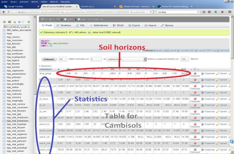
13 Descriptive statistics
,2) as Soil_pH_mean,tksp_group as Soil_horizon FROM kpp_kambizem GROUP BY")
14 SQL querying Example 1: Average soil ph for Cambisols by soil horizonts SELECT ROUND(avg(ex_ph),2) as Soil_pH_mean,tksp_group as Soil_horizon FROM kpp_kambizem GROUP BY tksp_group
,2) as Percentage, Clay' as Texture FROM kpp_kambizem")
,2), Sand' FROM kpp_kambizem WHERE")
15 SQL querying Example 2: Average contents of clay, silt and sand for A horizon in Cambisols SELECT ROUND(avg(jil),2) as Percentage, Clay' as Texture FROM kpp_kambizem WHERE tksp_group='a' UNION SELECT ROUND(avg(prach),2), Silt' FROM kpp_kambizem WHERE tksp_group='a' UNION SELECT ROUND(avg(pisek),2), Sand' FROM kpp_kambizem WHERE tksp_group='a'
Serbia. Serbian Environmental Protection Agency. Dragana Vidojevic. Danube Basin esoter soil database meeting, Ispra, 5/2/2015-6/2/2015
 Serbian Environmental Protection Agency Serbia Danube Basin esoter soil database meeting, Ispra, 5/2/2015-6/2/2015 Dragana Vidojevic Head of department for indicators and reporting air SEPA what we do...
The Evolution of NWI Mapping and How It Has Changed Since Inception
 The Evolution of NWI Mapping and How It Has Changed Since Inception Some Basic NWI Facts: Established in 1974 Goal to create database on characteristics and extent of U.S. wetlands Maps & Statistics In
Geological information for Europe : Towards a pan-european Geological Data Infrastructure
 Geological information for Europe : Towards a pan-european Geological Data Infrastructure Integrating geoscientific information for EU competitiveness Co-funded by the European Union European societal
Spatial modeling of pesticide emissions to groundwater and surface water in the Belgian context
 11/10/2012 Spatial modeling of pesticide emissions to groundwater and surface water in the Belgian context Bernhard s e-mail : 30 minutes => 20 minutes + 10 minutes discussion and award for best debater!
RESULTS OF DEVELOPMENT AND APPLICATION GEOGRAPHIC INFORMATION STANDARDS IN VIETNAM. Dr. Tran Bach Giang Vietnam
 RESULTS OF DEVELOPMENT AND APPLICATION GEOGRAPHIC INFORMATION STANDARDS IN VIETNAM Dr. Tran Bach Giang Vietnam Shibu lijack Contents 1. BACKGROUND 2. BASIC GEOGRAPHIC INFORMATION STANDARDS (BGIS) Background
VENETO REGION PILOT AREA
 VENETO REGION PILOT AREA The pilot area is located in the north-east of Veneto region, located itself in the north-east of Italy. The area borders with Austria are in the northern part and run along high
An internet based tool for land productivity evaluation in plot-level scale: the D-e-Meter system
 An internet based tool for land productivity evaluation in plot-level scale: the D-e-Meter system Tamas Hermann 1, Ferenc Speiser 1 and Gergely Toth 2 1 University of Pannonia, Hungary, tamas.hermann@gmail.com
Zdeněk Suchánek - Jaromír Řeřicha, CENIA, Czech Environmental Information Agency, Prague,
 UPDATE OF THE METHODOLOGY FOR RASTER DATA INTERPRETATION (REMOTE SENSING) FOR DETECTING CLUES OF CONTAMINATION WITHIN THE CONTAMINATED SITES INVENTORY PROJECT Zdeněk Suchánek - Jaromír Řeřicha, CENIA,
Danube Basin Soil Database
 1 Danube Basin Soil Database Beata Houšková Land Management and Natural Hazards Unit, Institute for Environment & Sustainability JRC TP 280 Ispra (VA) 21020 Italy E-mail: beata.houskova@jrc.it http://http://eusoils.jrc.ec.europa.eu/esbn/
ABSTRACT The first chapter Chapter two Chapter three Chapter four
 ABSTRACT The researches regarding this doctoral dissertation have been focused on the use of modern techniques and technologies of topography for the inventory and record keeping of land reclamation. The
Italian experience with the interpretation of FOCUS surface water scenarios from a regulatory point of view
 Italian experience with the interpretation of FOCUS surface water scenarios from a regulatory point of view G. Azimonti, G. Triacchini, D. Auteri, E. Redolfi, International Centre for Pesticides and Health
Scientific registration n : 2180 Symposium n : 35 Presentation : poster MULDERS M.A.
 Scientific registration n : 2180 Symposium n : 35 Presentation : poster GIS and Remote sensing as tools to map soils in Zoundwéogo (Burkina Faso) SIG et télédétection, aides à la cartographie des sols
Estimation of the area of sealed soil using GIS technology and remote sensing
 From the SelectedWorks of Przemysław Kupidura 2010 Estimation of the area of sealed soil using GIS technology and remote sensing Stanisław Białousz Przemysław Kupidura Available at: https://works.bepress.com/przemyslaw_kupidura/14/
Smart Data Collection and Real-time Digital Cartography
 Smart Data Collection and Real-time Digital Cartography Yuji Murayama and Ko Ko Lwin Division of Spatial Information Science Faculty of Life and Environmental Sciences University of Tsukuba IGU 2013 1
Creation of high resolution soil parameter data by use of artificial neural network technologies (advangeo )
") Creation of high resolution soil parameter data by use of artificial neural network technologies (advangeo ) A. Knobloch 1, F. Schmidt 1, M.K. Zeidler 1, A. Barth 1 1 Beak Consultants GmbH, Freiberg /
Creation of high resolution soil parameter data by use of artificial neural network technologies (advangeo ) A. Knobloch 1, F. Schmidt 1, M.K. Zeidler 1, A. Barth 1 1 Beak Consultants GmbH, Freiberg /
ISO Plant Hardiness Zones Data Product Specification
 ISO 19131 Plant Hardiness Zones Data Product Specification Revision: A Page 1 of 12 Data specification: Plant Hardiness Zones - Table of Contents - 1. OVERVIEW...3 1.1. Informal description...3 1.2. Data
Watershed Application of WEPP and Geospatial Interfaces. Dennis C. Flanagan
 Watershed Application of WEPP and Geospatial Interfaces Dennis C. Flanagan Research Agricultural Engineer USDA-Agricultural Research Service Adjunct Professor Purdue Univ., Dept. of Agric. & Biol. Eng.
Current LCLUC challenges in SCERIN: Assessing Ecosystem Function and Processes
 Summary of the SCERIN 2 meeting Current LCLUC challenges in SCERIN: Assessing Ecosystem Function and Processes Katarzyna Ostapowicz Department of GIS, Cartography and Remote Sensing, Institute of Geography
1. 1 What hazard maps have been developed in your country?
 REPUBLIC OF SLOVENIA MINISTRY OF DEFENCE ADMINISTRATION FOR CIVIL PROTECTION AND DISASTER RELIEF Kardeljeva plošcad 21, 1000 Ljubljana telephone: (+386) 1 471 33 22, fax: (+386) 1 431 81 17 ANSWERS TO
Chapter 6: Conclusion
 Chapter 6: Conclusion As stated in Chapter 1, the aim of this study is to determine to what extent GIS software can be implemented in order to manage, analyze and visually illustrate an IT-network between
Web Portal to European Soil Database
 Web Portal to European Soil Database A step towards harmonization of Soil Information in Europe Marc Van Liedekerke, Panos Panagos, Jean Dusart Soils Portal: http://eusoils.jrc.it Data The European Soil
The SDI-EDU project: Towards INSPIRE Awareness Raising on Example of Spatial Data Harmonization
 The SDI-EDU project: Towards INSPIRE Awareness Raising on Example of Spatial Data Harmonization Karel Janecka Otakar Cerba, Karel Jedlicka, Jan Jezek Faculty of Applied Sciences, University of West Bohemia
These modules are covered with a brief information and practical in ArcGIS Software and open source software also like QGIS, ILWIS.
 Online GIS Training and training modules covered are: 1. ArcGIS, Analysis, Fundamentals and Implementation 2. ArcGIS Web Data Sharing 3. ArcGIS for Desktop 4. ArcGIS for Server These modules are covered
LUCAS: current product and its evolutions
 LUCAS: current product and its evolutions Workshop Land Use and Land Cover products: challenges and opportunities Brussels 15 Nov 2017 Eurostat E4: estat-dl-lucas@ec.europa.eu Contents 1) The context 2)
for Effective Land Administration
 Role of Geospatial Technology in Land Information System(LIS) for Effective Land Administration Dr. Deb Jyoti Pal Sections Role of GIS in Land Records Proposed Work Flow Case Studies Role of GIS Creating
Harmonization of methods and measurements. Rainer Baritz
 Harmonization of methods and measurements Rainer Baritz ESP, Ispra, 21-22 May 2014 1 Context National contributions with harmonized data to. Improve cross-border and continental represenation for various
ANALYSIS OF LARGE SCALE SOIL SPECTRAL LIBRARIES
 Antoine Stevens (1), Marco Nocita (1,2), & Bas van Wesemael (1) ANALYSIS OF LARGE SCALE SOIL SPECTRAL LIBRARIES 1 Georges Lemaître Centre for Earth and Climate Research, Earth and Life Institute, UCLouvain,
State of the Art. in Spatial Planning Data Harmonisation & Spatial Data Infrastructure (SDI) Julia Neuschmid, CEIT ALANOVA
 Julia Neuschmid, CEIT ALANOVA") INSPIRE Conference, June 2010, Krakow State of the Art in Spatial Planning Data Harmonisation & Spatial Data Infrastructure (SDI) Julia Neuschmid, CEIT ALANOVA Co-funded by the Community programme econtentplus
INSPIRE Conference, June 2010, Krakow State of the Art in Spatial Planning Data Harmonisation & Spatial Data Infrastructure (SDI) Julia Neuschmid, CEIT ALANOVA Co-funded by the Community programme econtentplus
The road to national Inspire-compliant datasets in the Czech republic
 The road to national Inspire-compliant datasets in the Czech republic Ing. Pavel Šidlichovský (Land Survey Office of Czech Republic) INSPIRE 2014; 18.6. Aalborg Overview Directive transposition COSMC and
GIS sources for terrain analyses
 8.5. 11.5.2018 GIS sources for terrain analyses major Ing. Josef Rada University of Defence Brno Czech Republic 1 Introduction - Project of VGHMÚř and University of Defence; - objective: search for the
BASIC SPATIAL ANALYSIS TOOLS IN A GIS. data set queries basic statistics buffering overlay reclassification
 BASIC SPATIAL ANALYSIS TOOLS IN A GIS data set queries basic statistics buffering overlay reclassification GIS ANALYSIS TOOLS GIS ANALYSIS TOOLS Database tools: query and summarize (similar to spreadsheet
Calculating the Natura 2000 network area in Europe: The GIS approach
 Calculating the Natura 2000 network area in Europe: The GIS approach 1. INTRODUCTION A precise area calculation is needed to check to what extent member states have designated Natura 2000 sites of their
INSPIRE - A Legal framework for environmental and land administration data in Europe
 INSPIRE - A Legal framework for environmental and land administration data in Europe Dr. Markus Seifert Bavarian Administration for Surveying and Cadastre Head of the SDI Office Bavaria Delegate of Germany
Capabilities and Limitations of Land Cover and Satellite Data for Biomass Estimation in African Ecosystems Valerio Avitabile
 Capabilities and Limitations of Land Cover and Satellite Data for Biomass Estimation in African Ecosystems Valerio Avitabile Kaniyo Pabidi - Budongo Forest Reserve November 13th, 2008 Outline of the presentation
Overview of the current status of application of GIS and RS in soil and water management in Republic of Macedonia
 Overview of the current status of application of GIS and RS in soil and water management in Republic of Macedonia Dr. Dusko Mukaetov Institute of Agriculture Blvd. Aleksandar Makedonski b.b., 1000 Skopje,
Innovation in mapping and photogrammetry at the Survey of Israel
 16, October, 2017 Innovation in mapping and photogrammetry at the Survey of Israel Yaron Felus and Ronen Regev Contents Why HD mapping? Government requirements Mapping regulations o Quality requirements
A novel approach for validating raster datasets with categorical data
 A novel approach for validating raster datasets with categorical data E. Dobos, P. Vadnai, D. Bertóti, & K. Kovács University of Miskolc, Geography Institute, Miskolc-Egyetemváros, 3515. Hungary E. Micheli,
MANUAL ON THE BSES: LAND USE/LAND COVER
 6. Environment Protection, Management and Engagement 2. Environmental Resources and their Use 5. Human Habitat and Environmental Health 1. Environmental Conditions and Quality 4. Disasters and Extreme
Overview. Project Background Project Approach: Content and Application Development Application Demonstration Future Developments
 Overview Project Background Project Approach: Content and Application Development Application Demonstration Future Developments Southeast Pressures: Continued Population Growth Transportation Corridors
CentropeSTATISTICS Working Interactively with Cross-Border Statistic Data Clemens Beyer, Walter Pozarek, Manfred Schrenk
 Clemens Beyer, Walter Pozarek, Manfred Schrenk (Dipl.-Ing. Clemens Beyer, CEIT ALANOVA, Concorde Business Park 2/F, 2320 Schwechat, Austria, c.beyer@ceit.at) (Dipl.-Ing. Walter Pozarek, PGO Planungsgemeinschaft
Spectroscopy-supported digital soil mapping
 Spectroscopy-supported digital soil mapping Outline Introduction Project and theoretical background Field sampling Estimating and mapping soil mineralogy Conclusion & outlook The nation that destroys its
SRJC Applied Technology 54A Introduction to GIS
 SRJC Applied Technology 54A Introduction to GIS Overview Lecture of Geographic Information Systems Fall 2004 Santa Rosa Junior College Presented By: Tim Pudoff, GIS Coordinator, County of Sonoma, Information
Discrepancy in climatic zoning of the current soil productivity evaluation system
 Contributions to Geophysics and Geodesy Vol. 45/4, 2015 (255 268) Discrepancy in climatic zoning of the current soil productivity evaluation system Filip CHUCHMA 1,HanaSTŘEDOVÁ2 1 Czech Hydrometeorological
Introduction to Geographic Information Systems (GIS): Environmental Science Focus
: Environmental Science Focus") Introduction to Geographic Information Systems (GIS): Environmental Science Focus September 9, 2013 We will begin at 9:10 AM. Login info: Username:!cnrguest Password: gocal_bears Instructor: Domain: CAMPUS
Introduction to Geographic Information Systems (GIS): Environmental Science Focus September 9, 2013 We will begin at 9:10 AM. Login info: Username:!cnrguest Password: gocal_bears Instructor: Domain: CAMPUS
Yaneev Golombek, GISP. Merrick/McLaughlin. ESRI International User. July 9, Engineering Architecture Design-Build Surveying GeoSpatial Solutions
 Yaneev Golombek, GISP GIS July Presentation 9, 2013 for Merrick/McLaughlin Conference Water ESRI International User July 9, 2013 Engineering Architecture Design-Build Surveying GeoSpatial Solutions Purpose
The future of the Lowland Belizean Savannas?.
 The future of the Lowland Belizean Savannas?. Using cluster analysis to explore multivariate spatial patterns in savanna soils PETER FURLEY & SARAH BEADLE UK Belize association 15 th November 2014 Outline
Training on national land cover classification systems. Toward the integration of forest and other land use mapping activities.
 Training on national land cover classification systems Toward the integration of forest and other land use mapping activities. Guiana Shield 9 to 13 March 2015, Paramaribo, Suriname Background Sustainable
SAFMC Habitat and Ecosystem IMS. Habitat and Environmental Protection Advisory Panel Meeting
 SAFMC Habitat and Ecosystem IMS Habitat and Environmental Protection Advisory Panel Meeting Charleston, SC November 18, 2008 Project Overview Phase 1 develop and host an Internet Map Server (IMS) application
EEOS 381 -Spatial Databases and GIS Applications
 EEOS 381 -Spatial Databases and GIS Applications Lecture 5 Geodatabases What is a Geodatabase? Geographic Database ESRI-coined term A standard RDBMS that stores and manages geographic data A modern object-relational
Gistat: moving towards a location information management system
 Gistat: moving towards a location information management system (merging geographical, statistical and historical information) Pina Grazia Ticca Marco Ballin Istat - Italy Aguascalientes, Mexico 2-4 December
The Governance of Land Use
 The Governance of Land Use Country fact sheet Czech Republic The planning system Levels of government and their responsibilities The Czech Republic is a unitary state with 3 levels of government: the national
GIS FOR MAZOWSZE REGION - GENERAL OUTLINE
 GIS FOR MAZOWSZE REGION - GENERAL OUTLINE S. Bialousz 1), K Mączewski 2), E. Janczar 2), K. Osinska-Skotak 1) 1) Warsaw University of Technology, Warsaw, Poland 2) Office of the Surveyor of the Mazowieckie
Newsletter. Nr. 5 / June Special Issue HLanData Pilot Projects
 Nr. 5 / June 2012 Newsletter Special Issue HLanData Pilot Projects Pilot 1: Land Use and Land Cover Data Analysis System for Intermediate-Level Users The main objective of PILOT 1 is to demonstrate the
Thales Canada, System Division. BattleView: Integrating ArcGIS Into Canadian Army s Command And Control Application
 BattleView: Integrating ArcGIS Into Canadian Army s Command And Control Application BattleView Overview Canadian Army s command and control (C2) application Deployed in army headquarters unit and above
Procedure for Determining Near-Surface Pollution Sensitivity
 Procedure for Determining Near-Surface Pollution Sensitivity Minnesota Department of Natural Resources Division of Ecological and Water Resources County Geologic Atlas Program March 2014 Version 2.1 I.
Development of a Web-Based GIS Management System for Agricultural Authorities in Iraq
 Development of a Web-Based GIS Management System for Agricultural Authorities in Iraq USCID Water Management Conference Phoenix, Arizona April 18, 2013 Gabriele Bonaiti Extension Program Specialist David
BACHELOR OF GEOINFORMATION TECHNOLOGY (NQF Level 7) Programme Aims/Purpose:
 Programme Aims/Purpose:") BACHELOR OF GEOINFORMATION TECHNOLOGY ( Level 7) Programme Aims/Purpose: The Bachelor of Geoinformation Technology aims to provide a skilful and competent labour force for the growing Systems (GIS) industry
BACHELOR OF GEOINFORMATION TECHNOLOGY ( Level 7) Programme Aims/Purpose: The Bachelor of Geoinformation Technology aims to provide a skilful and competent labour force for the growing Systems (GIS) industry
Project Information system (Geodatabase) Norway Grants
 Norway Grants") Project Information system (Geodatabase) Norway Grants Lucie Kondrová Lenka Kociánová Zuzana Krejčí Martin Paleček Czech Geological Survey, Department of Information Systems 8.11. 2016 CZECH GEOLOGICAL
Project Information system (Geodatabase) Norway Grants Lucie Kondrová Lenka Kociánová Zuzana Krejčí Martin Paleček Czech Geological Survey, Department of Information Systems 8.11. 2016 CZECH GEOLOGICAL
NR402 GIS Applications in Natural Resources
 NR402 GIS Applications in Natural Resources Lesson 1 Introduction to GIS Eva Strand, University of Idaho Map of the Pacific Northwest from http://www.or.blm.gov/gis/ Welcome to NR402 GIS Applications in
The Danish Maritime Spatial Data Infrastructure (MSDI) Geodata of the Sea
 Geodata of the Sea") MSDI/MSP The Danish Maritime Spatial Data Infrastructure (MSDI) Geodata of the Sea Components of an infrastructure: DATA - metadata, datasets FUNCTIONALITY - spatial data services, web services and other
MSDI/MSP The Danish Maritime Spatial Data Infrastructure (MSDI) Geodata of the Sea Components of an infrastructure: DATA - metadata, datasets FUNCTIONALITY - spatial data services, web services and other
International Atomic Energy Agency Learning programme: Radon gas. Module 4: Developing and Implementing a Representative Indoor Radon Survey
 International Atomic Energy Agency Learning programme: Radon gas Module 4: Developing and Implementing a Representative Indoor Radon Survey Content Scope of this module Representative radon survey aims
Tomas Mildorf, Karel Janecka University of West Bohemia in Pilsen Czech Republic
 European Network of Best Practices for Interoperability of Spatial Planning Information Tomas Mildorf, Karel Janecka mildorf@centrum.cz, kjanecka@kma.zcu.cz University of West Bohemia in Pilsen Czech Republic
Introduction. Project Summary In 2014 multiple local Otsego county agencies, Otsego County Soil and Water
 Introduction Project Summary In 2014 multiple local Otsego county agencies, Otsego County Soil and Water Conservation District (SWCD), the Otsego County Planning Department (OPD), and the Otsego County
INTRODUCTION Landslides are bad but good
 Mapping Current and Future Landslide Susceptibility with GIS for the Tualatin Mountains, Oregon, USA Ian Cogar Jesse Roper INTRODUCTION Landslides are bad but good Avg. Annual Cost $2 billion and 20 50
C N E S, U M R I R I S A
 M O N I T O R I N G U R B A N A R E A S W I T H S E N T I N E L - 2. APPLICATION TO THE UPDATE OF THE COPERNICUS HIGH RESOLUTION LAYER IMPERVIOUSNESS DEGREE O c t o b e r 2 5 th 2016, Brussels A n t o
The Process of Spatial Data Harmonization in Italy. Geom. Paola Ronzino
 The Process of Spatial Data Harmonization in Italy Geom. Paola Ronzino ISSUES Geospatial Information in Europe: lack of data harmonization the lack of data duplication of data CHALLENGES Challenge of INSPIRE:
MATERHORN Field Campaign
 High Resolution Modeling for MATERHORN Field Campaign Applications to Synoptically Driven Flow Zachariah Silver, Reneta Dimitrova, and Tamás Zsedrovits Overview Adjusted WRF model setup Application to
Pilot area description Tissoe
 Pilot area description Tissoe October 2014 Mette V. Odgaard, department of Agroecology, Aarhus University Camilla Vestergaard, Knowledge Center for Agriculture P/S (eds.) 1 Content 1. General pilot area
The Governance of Land Use
 The planning system Levels of government and their responsibilities The Governance of Land Use COUNTRY FACT SHEET NORWAY Norway is a unitary state with three levels of government; the national level, 19
Spread over a central peninsula and its surroundings, Split's greater area includes the surrounding seaside towns as well.
 Split is a Mediterranean city on the eastern shores of the Adriatic Sea, centered around the ancient Roman Palace of the Emperor Diocletian and its bay and port. With a population of 178,192 citizens,
Ethiopia. January About this Report and the World Database on Protected Areas (WDPA)
") WDPA Data Status Report About this Report and the World Database on Protected Areas (WDPA) Map showing protected areas in the WDPA Ethiopia January 2015 The WDPA is the most comprehensive global dataset
WDPA Data Status Report About this Report and the World Database on Protected Areas (WDPA) Map showing protected areas in the WDPA Ethiopia January 2015 The WDPA is the most comprehensive global dataset
A Tool for Estimating Soil Water Available for Plants Using the 1:1,000,000 Scale Soil Geographical Data Base of Europe
 A Tool for Estimating Soil Water Available for Plants Using the :,000,000 Scale Soil Geographical Data Base of Europe Le Bas, D. King and J. Daroussin. Abstract INRA - SESCPF, Domaine de Limère, 4560 ARDON,
The potential of GIS in mapping soil health. Tim Brewer 19/11/2104
 The potential of GIS in mapping soil health Tim Brewer 19/11/2104 Horizon Depth (cm) Sand % Silt % Clay % ph Organic Carbon (wt%) Bulk Density (g/cm3) Particle Density (g/cm3) Total Porosity (%) Water
CalWeedMapper. Mapping the Spread of Invasive Plant Species. Karsten Vennemann. Seattle
 CalWeedMapper Mapping the Spread of Invasive Plant Species Karsten Vennemann Seattle Talk Overview The CalWeedMapper Project this presentation is about the expert online editing tool (part of larger project)
THE USE OF GEOMATICS IN CULTURAL HERITAGE AND ARCHAEOLOGY FOR VARIOUS PURPOSES
 THE USE OF GEOMATICS IN CULTURAL HERITAGE AND ARCHAEOLOGY FOR VARIOUS PURPOSES FEBRUARY 2013 AL BEIDA GEOPLAN CONTENT Company Profile Concept Objectives and Strategies Data Production Methods Data Samples
GIS Workshop Data Collection Techniques
 GIS Workshop Data Collection Techniques NOFNEC Conference 2016 Presented by: Matawa First Nations Management Jennifer Duncan and Charlene Wagenaar, Geomatics Technicians, Four Rivers Department QA #: FRG
Compact guides GISCO. Geographic information system of the Commission
 Compact guides GISCO Geographic information system of the Commission What is GISCO? GISCO, the Geographic Information System of the COmmission, is a permanent service of Eurostat that fulfils the requirements
SOLUTIONS ADVANCED GIS. TekMindz are developing innovative solutions that integrate geographic information with niche business applications.
 ADVANCED GIS SOLUTIONS TekMindz are developing innovative solutions that integrate geographic information with niche business applications. TEK INDZ TM GIS Services Overview At the leading edge of geospatial
THE DIGITAL SOIL MAP OF WALLONIA (DSMW/CNSW)
") THE DIGITAL SOIL MAP OF WALLONIA (DSMW/CNSW) Ph. Veron, B. Bah, Ch. Bracke, Ph. Lejeune, J. Rondeux, L. Bock Gembloux Agricultural University Passage des Déportés 2, B-5030 Gembloux, Belgium, geopedologie@fsagx.ac.be
THE DIGITAL SOIL MAP OF WALLONIA (DSMW/CNSW) Ph. Veron, B. Bah, Ch. Bracke, Ph. Lejeune, J. Rondeux, L. Bock Gembloux Agricultural University Passage des Déportés 2, B-5030 Gembloux, Belgium, geopedologie@fsagx.ac.be
GIS Final Project: Stage of Development Index. country s stage of development and how this relates to their impact on nature and the
 Group 4 Bridget Blair Mikhail Cunill Quinn Magevney Jordan Repollo GIS Final Project: Stage of Development Index Main Goal: Our goal is to take variables that are not inherently geospatial to better understand
Global Geospatial Information Management Country Report Finland. Submitted by Director General Jarmo Ratia, National Land Survey
 Global Geospatial Information Management Country Report Finland Submitted by Director General Jarmo Ratia, National Land Survey Global Geospatial Information Management Country Report Finland Background
Project based approach developing National Spatial Data Infrastructure in Lithuania
 Project based approach developing National Spatial Data Infrastructure in Lithuania National Land Service under the Ministry of Agriculture of The Republic of Lithuania Cadastres & Geodesy Department Director
Interoperability of Spatial Planning Data
 INSPIRE Conference 2010, Krakow, Poland Interoperability of Spatial Planning Data European Network of Best Practices for Interoperability of Spatial Planning Information Tomas Mildorf mildorf@centrum.cz
Fig. 1: Test area the Municipality of Mali Idjos, Cadastral Municipality Feketic
 Remote Sensing Application for Agricultural Land Value Classification Integrated in the Land Consolidation Survey Stojanka Brankovic, Ljiljana Parezanovic Republic Geodetic Authority, Belgrade, Serbia
ARCH PROJET Activity 1 -Synthesis-
 ARCH PROJET Activity 1 -Synthesis- CONTENT 1 ARCH project context... 3 1.1. General context... 3 1.2. The ARCH Project... 3 1.3. The Project ARCH partners... 3 1.4. The ARCH project content... 4 2 Activity
GIS Boot Camp for Education June th, 2011 Day 1. Instructor: Sabah Jabbouri Phone: (253) x 4854 Office: TC 136
 x 4854 Office: TC 136") GIS Boot Camp for Education June 27-30 th, 2011 Day 1 Instructor: Sabah Jabbouri Phone: (253) 833-9111 x 4854 Office: TC 136 Email: sjabbouri@greenriver.edu http://www.instruction.greenriver.edu/gis/ Summer
GIS Boot Camp for Education June 27-30 th, 2011 Day 1 Instructor: Sabah Jabbouri Phone: (253) 833-9111 x 4854 Office: TC 136 Email: sjabbouri@greenriver.edu http://www.instruction.greenriver.edu/gis/ Summer
ArcMap - EXPLORING THE DATABASE Part I. SPATIAL DATA FORMATS Part II
 Week 5 ArcMap - EXPLORING THE DATABASE Part I SPATIAL DATA FORMATS Part II topics of the week Exploring the Database More on the Table of Contents Exploration tools Identify, Find, Measure, Map tips, Hyperlink,
A framework for the 1:1,000,000 soil database of China
 Symposium no. 62 Paper no. 1757 Presentation: poster A framework for the 1:1,000,000 soil database of China SHI X.Z. (1), YU D.S. (1), PAN X.Z. (1), SUN W.X. (1), GONG Z.G. (1), Warner E.D. (2) and Petersen
GEOGRAPHIC INFORMATION SYSTEMS AND IT SOLUTIONS FOR THE ENVIRONMENT
 GEOGRAPHIC INFORMATION SYSTEMS AND IT SOLUTIONS FOR THE ENVIRONMENT Mission We focus on Solutions is a worldwide operating business offering Geographic Information Systems and IT solutions to assist environmental
GEO-DATA INPUT AND CONVERSION. Christos G. Karydas,, Dr. Lab of Remote Sensing and GIS Director: Prof. N. Silleos
 Christos G. Karydas,, Dr. xkarydas@agro.auth.gr http://users.auth.gr/xkarydas Lab of Remote Sensing and GIS Director: Prof. N. Silleos School of Agriculture Aristotle University of Thessaloniki, GR 1 0.
GEOMATICS. Shaping our world. A company of
 GEOMATICS Shaping our world A company of OUR EXPERTISE Geomatics Geomatics plays a mayor role in hydropower, land and water resources, urban development, transport & mobility, renewable energy, and infrastructure
Geospatial SDI Portal for effective Governance of Pune METROPOLIS region
 Geospatial SDI Portal for effective Governance of Pune METROPOLIS region Mr. Praveen Gautam Senior Manager 19 th January 2018 PMRDA Overview Provide a Spatial Framework for the entire region with various
Watershed Classification with GIS as an Instrument of Conflict Management in Tropical Highlands of the Lower Mekong Basin
 Page 1 of 8 Watershed Classification with GIS as an Instrument of Conflict Management in Tropical Highlands of the Lower Mekong Basin Project Abstract The University of Giessen is actually planning a research
New Digital Soil Survey Products to Quantify Soil Variability Over Multiple Scales
 2006-2011 Mission Kearney Foundation of Soil Science: Understanding and Managing Soil-Ecosystem Functions Across Spatial and Temporal Scales Progress Report: 2006021, 1/1/2007-12/31/2007 New Digital Soil
Predicting ectotherm disease vector spread. - Benefits from multi-disciplinary approaches and directions forward
 Predicting ectotherm disease vector spread - Benefits from multi-disciplinary approaches and directions forward Naturwissenschaften Stephanie Margarete THOMAS, Carl BEIERKUHNLEIN, Department of Biogeography,
Keywords: Wind resources assessment, Wind maps, Baltic Sea, GIS
 Advanced Materials Research Online: 2013-10-31 ISSN: 1662-8985, Vol. 827, pp 153-156 doi:10.4028/www.scientific.net/amr.827.153 2014 Trans Tech Publications, Switzerland Mapping of Offshore Wind Climate
Land Use and Land cover statistics (LUCAS)
") EUROPEAN COMMISSION EUROSTAT Directorate E: Sectoral and regional statistics Doc. ENV/DIMESA/7.1/2012 Original in EN Agenda point 7.1 Land Use and Land cover statistics (LUCAS) DIMESA Directors' Meeting
EUROPEAN COMMISSION EUROSTAT Directorate E: Sectoral and regional statistics Doc. ENV/DIMESA/7.1/2012 Original in EN Agenda point 7.1 Land Use and Land cover statistics (LUCAS) DIMESA Directors' Meeting
Pegaso map viewer workshop
 PEGASO / 05 Deliverable Plan 2010-12-23 Pegaso Project People for Ecosystem based Governance in Assessing Sustainable development of Ocean and coast Funded by the European Union under FP7 ENV.2009.2.2.1.4
Resilient Landscapes Fund
 Resilient Landscapes Fund Definitions and Map Guide 2017 This document includes definitions of key terms and instructions for developing maps for application to OSI s Resilient Landscapes Fund. INTRODUCTION
Imagery and the Location-enabled Platform in State and Local Government
 Imagery and the Location-enabled Platform in State and Local Government Fred Limp, Director, CAST Jim Farley, Vice President, Leica Geosystems Oracle Spatial Users Group Denver, March 10, 2005 TM TM Discussion