Current LCLUC challenges in SCERIN: Assessing Ecosystem Function and Processes
|
|
|
- Stephany Bond
- 6 years ago
- Views:
Transcription

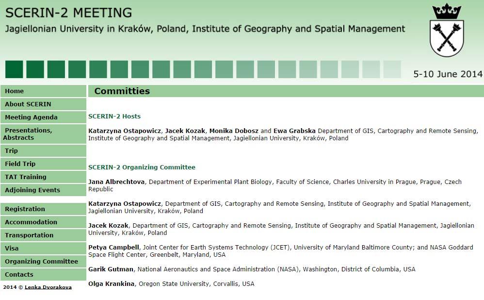
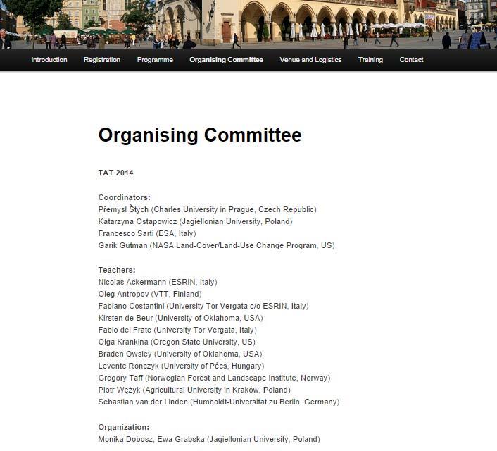
1 Summary of the SCERIN 2 meeting Current LCLUC challenges in SCERIN: Assessing Ecosystem Function and Processes Katarzyna Ostapowicz Department of GIS, Cartography and Remote Sensing, Institute of Geography and Spatial Management, Jagiellonian University, Kraków, Poland
2 SCERIN network [South Central and Eastern European Regional Information Network] Aim: to promote the use and improve the quality and availability of Earth System remote sensing data in South Central and Eastern Europe (SCE) SCERIN Cross cutting Thematic Areas include: Detection and analysis of Land Use and Land Cover Change Impacts of Land Use and Land Cover Change on the Regional, National and Local Management, specifically: Forest and Water Resource Management, Biodiversity and species preservation, Sustainable Development and Natural Resource Management, Global and Regional Climate Change, Assessment of the Human Dimensions of Land Use and Land Cover Change
3 SCERIN network [South Central and Eastern European Regional Information Network] the SCERIN focus groups: FG1: Forest monitoring: disturbances, health and biomass, FG2: Land Cover Changes: agricultural land abandonment, urban expansion; and to discuss the formulation of New FG3: Validation/verification network for support of current and future satellite NASA (HyspIRI, Landsat) and ESA missions (GMES program).


4 SCERIN Road Map SCERIN 3 Brasov 2015 Jana Albrechtova Charles University in Prague Petya Campbell University in Maryland SCERIN 2 Kraków 2014 SCERIN 1 Prague 2013 Tartu 2010 Kick off Sofia 2012

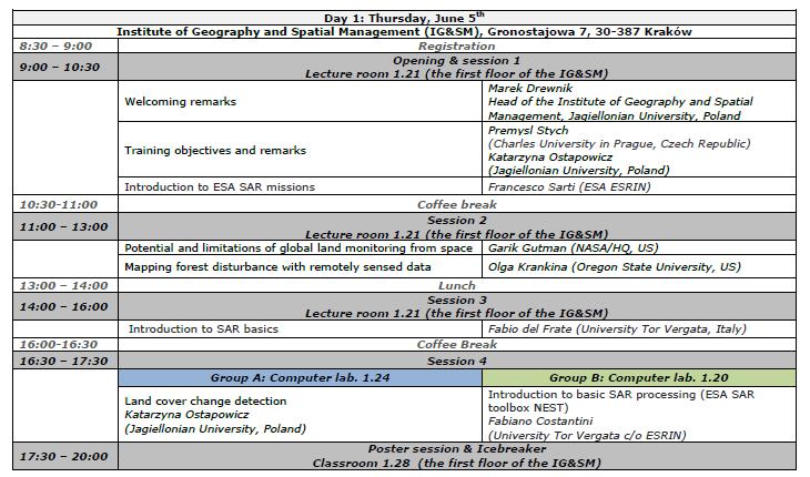
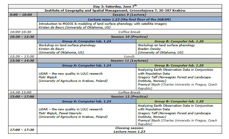
5 SCERIN 2 meeting focus on regional and local issues related to satellite data products, methodologies, and end users June 5th to June 10th TAT training SCERIN meeting day 1 day 2 day 3 Trip day 1 day 2 Department of GIS, Cartography and Remote Sensing, Institute of Geography and Spatial Management, Jagiellonian University, Kraków, Poland
6 SCERIN 2 meeting aim Provide forum and opportunity for the SCERIN Form Focus Groups (FGs) to resolve specific issues (actions) as requested by the community Review the availability of satellite data, products, and approaches for land cover monitoring in South Central and Eastern Europe (SCE) Outline the specific land cover and land use change research, applications and development needs in the SCE region; Inform about ongoing major scientific efforts and projects with possible contribution and follow up activities of the SCERIN participants
7


8 50 participants of the SCERIN meeting Armenia Bulgaria Georgia Moldova Norway Switzerland the Netherlands Turkey Croatia Hungary Romania Slovakia Ukraine Czech Republik USA Poland


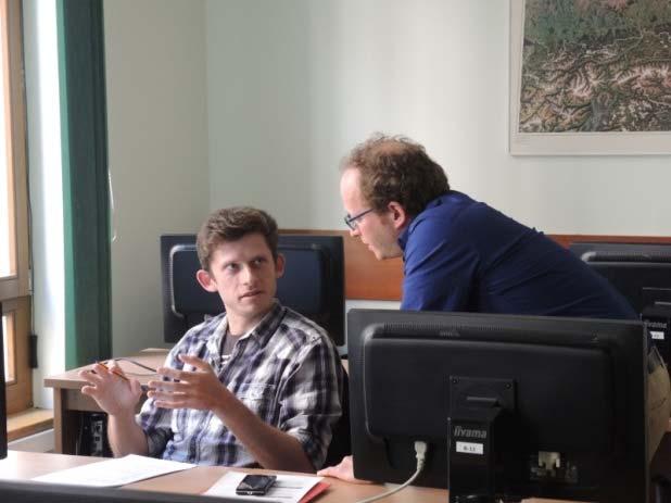
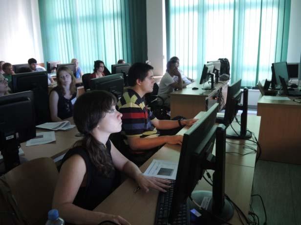
9 Agenda Session 1: Key notes and programmatic lectures Session 2: SCERIN Goals and Directions Session 3: Land cover and land use change (FG2) Session 4: Land cover and land use change Polish contribution (FGs 1 3) Session 5: Land Cover Change and Ecosystem/Landscape assessment (FG 1 and FG3) SCERIN Focus groups discussions Key Lecture and Icebreaker Social 34 presentations

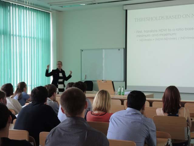
10 SCERIN 2 meeting day 1 Update on the state of the art in LCLUC research in SCERIN

11 SCERIN 2 meeting day 1 Update on the state of the art in LCLUC research in SCERIN


12 Why past land use matters: Learning from the Carpathians, Catalina Munteanu et al.. Agriculture changes in European Russia, Kirsten de Beurs et al. A FUSED DISTURBANCE MODEL FOR LAND MANAGEMENT ANALYSIS IN NEW ZEALAND using MODIS and Landsat time series, Braden Owsley et al. Land use and land cover change in the Republic of Moldova, Tatiana Popusoi et al.

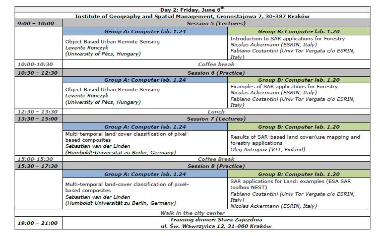
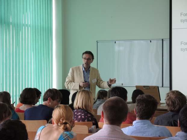
13 SCERIN 2 meeting day 2
14 FG1: Forest ecosystem monitoring: disturbances, health and biomass assessment using hyperspectral, LiDAR data + FG 3 Project applications in future: Networking: COST? Volunteer for the Main Coordinator wanted NATO meeting, publication EU: Horizon 2020, Life+, ESA, Visegrad Fund International projects e.g. NASA Groups of interest: climate change, C fluxes, forest ecosystem services, bark beetle, soil acidification, heavy metal pollution, identification of driving forces of LCLUC, European forest map (different scales of details), Forest inventory and RS definitions, Monitoring forest health by qualitative RS, Monitoring forest composition, natural ecosystem disturbances in protected areas, Validation of the forest cover products, Grassland functioning, detection of grassland management, RS of forest ecosystems in Central, (Eastern) Europe review paper?
15 FG2: Land Cover Changes: effects of agricultural land abandonment, urban expansion and climate change What are the causes/drivers of the process? What are the consequences for landscape positive/negative? What are the research questions? What are the monitoring methods? What data sources can be used to evaluate the process? What are the scales for the research? What are the needs of stakeholders? Is the process addressed for the territory of SCERIN countries? What are the research gaps? Who has some project related with the processes? Can some of these processes be a good base for the common research of SCERIN countries?

 SCERIN 3 meeting: summer 2015")
16 Further activities new research projects (identification of calls/frameworks) further development of applications and capacity building initiatives to be conducted by the network which will focus on mostly regional issues next network meetings and trainings (networking) SCERIN 3 meeting: summer 2015 Brasov, Romania

17

18

19 39 students nationality study/working place Man Female Brazil Bulgaria Lithuanian Georgia Spain India Nepal Italy Slovakia Estonia Hungary Czech Republic Poland Bulgaria Lithuanian Germany Netherlands Slovakia Estonia Hungary Czech Republic Poland

20 Program
21
22 Thank you for your attention!
SCERIN Overview SCERIN-4 Goals and Workshop Agenda
 The GOFC-GOLD South Central and Eastern European Network (SCERIN) SCERIN Overview SCERIN-4 Goals and Workshop Agenda Petya Campbell 1, Jana Albrechtová 2 and Lucie Kupková 2 1 Joint Center for Earth Systems
SCERIN Overview SCERIN-5 Goals and Workshop Agenda
 The GOFC-GOLD South Central and Eastern European Network (SCERIN) SCERIN Overview SCERIN-5 Goals and Workshop Agenda Petya Campbell 1, Jana Albrechtová 2 and Lucie Kupková 2 1 Joint Center for Earth Systems
The Joint Programming Initiative on Cultural Heritage (JPICH): European perspective
: European perspective") COPERNICUS FOR CULTURAL HERITAGE Copernicus User Forum Industry Workshop Brussels, 24 April 2017 The Joint Programming Initiative on Cultural Heritage (JPICH): European perspective Cristina Sabbioni CNR,
COPERNICUS FOR CULTURAL HERITAGE Copernicus User Forum Industry Workshop Brussels, 24 April 2017 The Joint Programming Initiative on Cultural Heritage (JPICH): European perspective Cristina Sabbioni CNR,
Economic and Social Council
 United Nations Economic and Social Council Distr.: General 30 August 2012 Original: English Economic Commission for Europe Inland Transport Committee Working Party on Rail Transport Sixty-sixth session
AD HOC DRAFTING GROUP ON TRANSNATIONAL ORGANISED CRIME (PC-GR-COT) STATUS OF RATIFICATIONS BY COUNCIL OF EUROPE MEMBER STATES
 STATUS OF RATIFICATIONS BY COUNCIL OF EUROPE MEMBER STATES") Strasbourg, 29 May 2015 PC-GR-COT (2013) 2 EN_Rev AD HOC DRAFTING GROUP ON TRANSNATIONAL ORGANISED CRIME (PC-GR-COT) STATUS OF RATIFICATIONS BY COUNCIL OF EUROPE MEMBER STATES TO THE UNITED NATIONS CONVENTION
Strasbourg, 29 May 2015 PC-GR-COT (2013) 2 EN_Rev AD HOC DRAFTING GROUP ON TRANSNATIONAL ORGANISED CRIME (PC-GR-COT) STATUS OF RATIFICATIONS BY COUNCIL OF EUROPE MEMBER STATES TO THE UNITED NATIONS CONVENTION
Institute of Geography and Spatial Management, Faculty of Geography and Geology, Jagiellonian University
 International workshop on ecological connectivity modelling 6-9 March 2017 Institute of Geography and Spatial Management, Faculty of Geography and Geology, Jagiellonian University From 6 th to 9 th of
EO4SEE - THE PATHFINDER OF OPERATIONAL SATELLITE MONITORING FOR THE REGION OF THE BLACK SEA AND CENTRAL EUROPE
 EO4SEE: Pathfinder assessment for regional high volume data access, processing and information service delivery platforms - South East Region EO4SEE - THE PATHFINDER OF OPERATIONAL SATELLITE MONITORING
I&CLC2000 in support to new policy initiatives (INSPIRE, GMES,..)
") I&CLC2000 in support to new policy initiatives (INSPIRE, GMES,..) Manfred Grasserbauer, Director Joint Research Centre Institute for Environment and Sustainability 1 IMAGE 2000 European mosaic of satellite
I&CLC2000 in support to new policy initiatives (INSPIRE, GMES,..) Manfred Grasserbauer, Director Joint Research Centre Institute for Environment and Sustainability 1 IMAGE 2000 European mosaic of satellite
Appendix B: Detailed tables showing overall figures by country and measure
 44 country and measure % who report that they are very happy Source: World Values Survey, 2010-2014 except United States, Pew Research Center 2012 Gender and Generations survey and Argentina 32% 32% 36%
Securing EUMETSAT s Mission from an Evolving Space Environment
 Securing EUMETSAT s Mission from an Evolving Space Environment ESPI 12 th Autumn Conference Andrew Monham 1 EUMETSAT: Intergovernmental Organisation of 30 Member States Presentation Contents AUSTRIA BELGIU
Carpathians Unite mechanism of consultation and cooperation for implementation of the Carpathian Convention
 Carpathians Unite mechanism of consultation and cooperation for implementation of the Carpathian Convention Zbigniew Niewiadomski, UNEP/GRID-Warsaw Centre First Joint Meeting of the Carpathian Convention
WHO EpiData. A monthly summary of the epidemiological data on selected Vaccine preventable diseases in the WHO European Region
 A monthly summary of the epidemiological data on selected Vaccine preventable diseases in the WHO European Region Table 1: Reported cases for the period January December 2018 (data as of 01 February 2019)
The EuCheMS Division Chemistry and the Environment EuCheMS/DCE
 The EuCheMS Division Chemistry and the Environment EuCheMS/DCE EuCheMS Division on Chemistry and the Environment was formed as a FECS Working Party in 1977. Membership: 37 members from 34 countries. Countries
Land Use and Land cover statistics (LUCAS)
") EUROPEAN COMMISSION EUROSTAT Directorate E: Sectoral and regional statistics Doc. ENV/DIMESA/7.1/2012 Original in EN Agenda point 7.1 Land Use and Land cover statistics (LUCAS) DIMESA Directors' Meeting
EUROPEAN COMMISSION EUROSTAT Directorate E: Sectoral and regional statistics Doc. ENV/DIMESA/7.1/2012 Original in EN Agenda point 7.1 Land Use and Land cover statistics (LUCAS) DIMESA Directors' Meeting
EuroGeoSurveys An Introduction
 EGS -ASGMI Workshop, Madrid, 2015 EuroGeoSurveys An Introduction 40 Years Listening to the Beat of the Earth Click to edit Master title Albania style EuroGeoSurveys Austria Lithuania Luxembourg Belgium
GEOGRAPHY (GE) Courses of Instruction
 Courses of Instruction") GEOGRAPHY (GE) GE 102. (3) World Regional Geography. The geographic method of inquiry is used to examine, describe, explain, and analyze the human and physical environments of the major regions of the
GEOGRAPHY (GE) GE 102. (3) World Regional Geography. The geographic method of inquiry is used to examine, describe, explain, and analyze the human and physical environments of the major regions of the
Final report for the Expert Group on the Integration of Statistical and Geospatial Information, May 2015
 Final report for the Expert Group on the Integration of Statistical and Geospatial Information, May 2015 Global geographic classification and geocoding practices Executive summary This final report was
A Markov system analysis application on labour market dynamics: The case of Greece
 + A Markov system analysis application on labour market dynamics: The case of Greece Maria Symeonaki Glykeria Stamatopoulou This project has received funding from the European Union s Horizon 2020 research
European Topic Centre on Land Urban and Soil Systems. Green Infrastructure at EEA
 Green Infrastructure at EEA A SPATIAL APPROACH TO MAPPING GI Stefan Kleeschulte, ETC ULS GI and territorial cohesion 2011 first EEA report on Green Infrastructure Underlining the need to develop tools
Biodiversity and Ecosystem services Thinking globally, acting locally
 Biodiversity and Ecosystem services Thinking globally, acting locally Anne-Gaelle Ausseil - Manaaki Whenua Landcare Research Geoff Hicks National Commission for UNESCO 1 8 / 1 0 / 2 0 1 8 M A N A A K I
PLUTO The Transport Response to the National Planning Framework. Dr. Aoife O Grady Department of Transport, Tourism and Sport
 PLUTO 2040 The Transport Response to the National Planning Framework Dr. Aoife O Grady Department of Transport, Tourism and Sport Dublin Economics Workshop 15 th September 2018 The Story of Pluto National
SDG s and the role of Earth Observation
 SDG s and the role of Earth Observation Christian Heipke IPI - Institute for Photogrammetry and GeoInformation Leibniz Universität Hannover Germany Secretary General, ISPRS 1. No Poverty 2. Zero Hunger
WHO EpiData. A monthly summary of the epidemiological data on selected Vaccine preventable diseases in the European Region
 A monthly summary of the epidemiological data on selected Vaccine preventable diseases in the European Region Table : Reported measles cases for the period January December 207 (data as of 02 February
WHO EpiData. A monthly summary of the epidemiological data on selected Vaccine preventable diseases in the European Region
 A monthly summary of the epidemiological data on selected Vaccine preventable diseases in the European Region Table : Reported measles cases for the period July 207 June 208 (data as of August 208) Population
WHO EpiData. A monthly summary of the epidemiological data on selected Vaccine preventable diseases in the European Region
 A monthly summary of the epidemiological data on selected Vaccine preventable diseases in the European Region Table : Reported cases for the period June 207 May 208 (data as of 0 July 208) Population in
WHO EpiData. A monthly summary of the epidemiological data on selected Vaccine preventable diseases in the WHO European Region
 A monthly summary of the epidemiological data on selected Vaccine preventable diseases in the WHO European Region Table : Reported cases for the period November 207 October 208 (data as of 30 November
WHO EpiData. A monthly summary of the epidemiological data on selected Vaccine preventable diseases in the European Region
 A monthly summary of the epidemiological data on selected Vaccine preventable diseases in the European Region Table : Reported cases for the period September 207 August 208 (data as of 0 October 208) Population
International and regional network status
 WORLD METEOROLOGICAL ORGANIZATION JOINT MEETING OF CBS EXPERT TEAM ON SURFACE-BASED REMOTELY- SENSED OBSERVATIONS (Second Session) AND CIMO EXPERT TEAM ON OPERATIONAL REMOTE SENSING (First Session) CBS/ET-SBRSO-2
ACCESSIBILITY TO SERVICES IN REGIONS AND CITIES: MEASURES AND POLICIES NOTE FOR THE WPTI WORKSHOP, 18 JUNE 2013
 ACCESSIBILITY TO SERVICES IN REGIONS AND CITIES: MEASURES AND POLICIES NOTE FOR THE WPTI WORKSHOP, 18 JUNE 2013 1. Significant differences in the access to basic and advanced services, such as transport,
MAPPING LAND COVER OF EUROPE FOR 2006 UNDER GMES
 Proceedings of the 2 nd Workshop of the EARSeL SIG on Land Use and Land Cover MAPPING LAND COVER OF EUROPE FOR 2006 UNDER GMES Chris Steenmans 1 and George Büttner 2 1. European Environment Agency, Kongens
Empowered lives. Resilient nations. Data for People and Planet. powered by
 Empowered lives. Resilient nations. Data for People and Planet powered by Overview As we enter the fourth industrial revolution, technology is revolutionizing our ability to map nature. Satellite data
European Landscape Convention in the Slovak Republic
 13th COUNCIL OF EUROPE MEETING OF THE WORKSHOPS FOR THE EUROPEAN LANDSCAPE CONVENTION European Landscape Convention in the Slovak Republic Mrs. Ida Vanáková, state advisor, Department of Spatial Planning
ESPON support for Targeted Analyses Ilona Raugze Director
 ESPON support for Targeted Analyses Ilona Raugze Director ESPON EGTC 14 November 2017 ESPON EGTC workshop Targeted Analysis in support of better policy making in cities and regions Inspire policy making
WHO EpiData. A monthly summary of the epidemiological data on selected vaccine preventable diseases in the European Region
 A monthly summary of the epidemiological data on selected vaccine preventable diseases in the European Region Table 1: Reported measles cases for the 12-month period February 2016 January 2017 (data as
LAND COVER CHANGES IN ROMANIA BASED ON CORINE LAND COVER INVENTORY
 LAND COVER CHANGES IN ROMANIA BASED ON CORINE LAND COVER INVENTORY 1990 2012 JENICĂ HANGANU, ADRIAN CONSTANTINESCU * Key-words: CORINE Land Cover inventory, Land cover changes, GIS. Abstract. From 1990
04 June Dim A W V Total. Total Laser Met
 4 June 218 Member State State as on 4 June 218 Acronyms are listed in the last page of this document. AUV Mass and Related Quantities Length PR T TF EM Mass Dens Pres F Torq Visc H Grav FF Dim A W V Total
JRC MARS Bulletin Crop monitoring in Europe. January 2017 Minor frost damages so far. Improved hardening of winter cereals in central Europe
 MARS Bulletin Vol. 25 No 1 23 January 2017 1 JRC MARS Bulletin Vol. 25 No 1 Period covered: 1 December 2016-16 January 2017 Issued: 23 January 2017 JRC MARS Bulletin Crop monitoring in Europe January 2017
EU GeoCapacity. Assessing European Capacity for Geological Storage of Carbon Dioxide. Thomas Vangkilde-Pedersen, GEUS
 EU GeoCapacity Assessing European Capacity for Geological Storage of Carbon Dioxide Thomas Vangkilde-Pedersen, GEUS GeoCapacity results and the future for geological storage of CO 2 EU GeoCapacity open
Part 2. Cost-effective Control of Acidification and Ground-level Ozone
 8 th INTERIM REPORT Part 2 Cost-effective Control of Acidification and Ground-level Ozone Markus Amann, Imrich Bertok, Janusz Cofala, Frantisek Gyarfas, Chris Heyes, Zbigniew Klimont, Wolfgang Schöpp March
EuroGeoSurveys & ASGMI The Geological Surveys of Europe and IberoAmerica
 EuroGeoSurveys & ASGMI The Geological Surveys of Europe and IberoAmerica Geological Surveys, what role? Legal mandate for data & information: Research Collection Management Interpretation/transformation
Geospatial workflows and potential applications to the Sustainable Development Goals of countries in West Asia
 Geospatial workflows and potential applications to the Sustainable Development Goals of countries in West Asia Ameer Abdulla, PhD Senior Advisor, European Topic Center for Spatial Analysis, Spain Associate
EUMETSAT. A global operational satellite agency at the heart of Europe. Presentation for the Spanish Industry Day Madrid, 15 March 2012
 EUMETSAT A global operational satellite agency at the heart of Europe Presentation for the Spanish Industry Day Madrid, Angiolo Rolli EUMETSAT Director of Administration EUMETSAT objectives The primary
Implementation of the ESPON 2020 cooperation program. 16 January 2017 Anneloes van Noordt
 Implementation of the ESPON 2020 cooperation program 16 January 2017 Anneloes van Noordt Outline! ESPON Cooperation Program! Specific Objectives! Applied Research! Targeted Analysis! Database & Tools!
JRC MARS Bulletin Crop monitoring in Europe January 2019
 Online version Issued: 21 January 2019 r JRC MARS Bulletin Vol. 27 No 1 JRC MARS Bulletin Crop monitoring in Europe January 2019 Continued mild winter Improved hardening of winter cereals in central and
ICZM and MSP in the Black Sea Region
 ICZM and MSP in the Black Sea Region Drd. Claudia Coman, Environmental engineer AG ICZM Focal Point, Romania Black Sea Commission Black Sea Commission on the Protection of the Black Sea against Pollution
The Spatial Information Corridor Contributes to UNISPACE+50. JIANG HUI Director of Internation Cooperation Department
 The Spatial Information Corridor Contributes to UNISPACE+50 JIANG HUI Director of Internation Cooperation Department 01 02 03 What is Belt & Road Spatial Information Corridor? China put forward the "Belt
EuroGEOSS Protected Areas Pilot
 EuroGEOSS Protected Areas Pilot Max Craglia European Commission Joint Research Centre Part 1: the present MyNatura2000 Mobile app. Awareness raising & volunteered data collection. Natura2000 covers 18%
A COMPREHENSIVE WORLDWIDE WEB-BASED WEATHER RADAR DATABASE
 A COMPREHENSIVE WORLDWIDE WEB-BASED WEATHER RADAR DATABASE Oguzhan SİRECİ 1, Paul JOE 2, Serkan EMINOGLU 3, Kamuran AKYILDIZ 4 1 Turkish State Meteorological Service(TSMS), Kecioren, Ankara Turkey,osireci@gmail.com
Investigation of the Effect of Transportation Network on Urban Growth by Using Satellite Images and Geographic Information Systems
 Presented at the FIG Congress 2018, May 6-11, 2018 in Istanbul, Turkey Investigation of the Effect of Transportation Network on Urban Growth by Using Satellite Images and Geographic Information Systems
*CETAF : DOI: /RG
 Consortium of European Taxonomic Facilities STRATEGY AND STRATEGIC DEVELOPMENT PLAN * Executive Summary Exploring and documenting diversity in nature *CETAF Strategy and Strategic Development Plan 2015-2025:
About the Authors Geography and Tourism: The Attraction of Place p. 1 The Elements of Geography p. 2 Themes of Geography p. 4 Location: The Where of
 Preface p. ix About the Authors p. xi Geography and Tourism: The Attraction of Place p. 1 The Elements of Geography p. 2 Themes of Geography p. 4 Location: The Where of Geography p. 4 Place and Space:
Land abandonment and recultivation in Central and Eastern Europe
 Land abandonment and recultivation in Central and Eastern Europe Patrick Hostert Patrick Griffiths, Stephan Estel, Camilo Alcantara, Tobias Kuemmerle, Dirk Pflugmacher, Alexander Prishchepov, Volker Radeloff
The ESPON Programme. Goals Main Results Future
 The ESPON Programme Goals Main Results Future Structure 1. Goals Objectives and expectations Participation, organisation and networking Themes addressed in the applied research undertaken in ESPON projects
SPLAN-Natura Towards an integrated spatial planning approach for Natura th January, 2017 Brussels. Commissioned by DG Environment
 SPLAN-Natura 2000 Towards an integrated spatial planning approach for Natura 2000 Commissioned by DG Environment 17 th January, 2017 Brussels V. Simeonova (Ph.D.) Drivers towards integrating Biodiversity
National Remote Sensing Center of China. Space Technology for Sustainable Development in China Status, Achievements and Futures.
 National Remote Sensing Center of China Space Technology for Sustainable Development in China Status, Achievements and Futures Jing Li National Remote Sensing Center of China Ministry of Science and Technology,
Geographic Information Infrastructure and Policy Framework for Sustainable Mountain Development in the Hindu Kush-Himalayas
 Geo SMART ASIA 2017 22-24 August, Kualalampur Geographic Information Infrastructure and Policy Framework for Sustainable Mountain Development in the Hindu Kush-Himalayas Basanta Shrestha, Director Strategic
IPWG recent accomplishments and future directions
 IPWG recent accomplishments and future directions Paul Kucera (NCAR, Boulder, USA) And Bozena Lapeta (IMWM Krakow, Poland) with additions by Volker Gärtner (EUMETSAT, IPWG Rapporteur) IPWG Objectives IPWG
Regionalized and application-specific compositing - a review of requirements, opportunities and challenges
 Regionalized and application-specific compositing - a review of requirements, opportunities and challenges Patrick Griffiths & Patrick Hostert Geography Department, Humboldt University Berlin Joanne White
The Combination of Geospatial Data with Statistical Data for SDG Indicators
 Session x: Sustainable Development Goals, SDG indicators The Combination of Geospatial Data with Statistical Data for SDG Indicators Pier-Giorgio Zaccheddu Fabio Volpe 5-8 December2018, Nairobi IAEG SDG
Use of satellite information in research and operational activities at NIMH of Bulgaria
 Use of satellite information in research and operational activities at NIMH of Bulgaria Rilka Valcheva NIMH, Bulgaria WMO/EUMETSAT Satellite Products Training Course 24-28 April 2017, Budapest, Hungary
JRC MARS Bulletin Crop monitoring in Europe January 2016 Weakly hardened winter cereals
 Online version Issued: 25January 2016 r JRC MARS Bulletin Vol. 24 No 1 JRC MARS Bulletin Crop monitoring in Europe January 2016 Weakly hardened winter cereals A first cold spell is likely to have caused
USDA Dairy Import License Circular for 2018
 USDA Dairy Import License Circular for 2018 Commodity/Note Country Name TRQ Jan Feb Mar Apr May Jun Jul Aug Sep Oct Nov Grand Total Non-Cheese 21,864,781 624,064 651,121 432,669 901,074 1,202,567 907,493
The European height reference system and its realizations
 The European height reference system and its realizations Martina Sacher, Gunter Liebsch EUREF symposium 2015 Tutorial Height & Gravity June 02, Leipzig, Germany Contents 1. UELN-forerunner - Steps of
CropCast Europe Weekly Report
 CropCast Europe Weekly Report Kenny Miller Monday, June 05, 2017 Europe Hot Spots Abundant showers should ease dryness across northern and central UK as well as across western Norway and Sweden. Improvements
Navigable maritime and river waterways in the seaside - Danube Delta area and the connected rural development
 SUMMARY OF Ph-D Thesis, with title RESEARCH STUDIES ON MANAGEMENT IMPROVEMENT OF MARITIME AND RIVER TRANSPORT ACTIVITY IN THE COASTAL AND DANUBE DELTA AREA FROM AN ENVIROMENTAL, ECONOMIC AND SOCIAL PERSPECTIVE
40 Years Listening to the Beat of the Earth
 EuroGeoSurveys The role of EuroGeoSurveys in Europe-Africa geoscientific cooperation 40 Years Listening to the Beat of the Earth EuroGeoSurveys 32 Albania Lithuania Austria Luxembourg Belgium The Netherlands
Arctic Observing Systems Challenges, New opportunities and Integration
 Arctic Observing Systems Challenges, New opportunities and Integration Japan Norway Arctic Science Week 03 June 2016 By Stein Sandven, NERSC Building an integrated Arctic Observing System Need to collect,
Green areas: numerous positive effects for sustainable metropolis Satellite images : an easy way to map vegetation
 Green areas: numerous positive effects for sustainable metropolis Satellite images : an easy way to map vegetation Copernicus Training and Information Session 10 and 11 may 2017 in Lund, Sweden Dominique
Canadian Imports of Honey
 of 0409000029 - Honey, natural, in containers of a weight > 5 kg, nes (Kilogram) Argentina 236,716 663,087 2,160,216 761,990 35.27% 202.09% /0 76,819 212,038 717,834 257,569 35.88% 205.69% /0 United States
Meteorological similarities and differences of the great European floods
 Meteorological similarities and differences of the great European floods Nataša Strelec Mahović DHMZ Meteorological and Hydrological Service, Croatia Europe floods 1998-2008 Areas most frequently affected
Skype: konrad.turlej phone:
 Konrad Ireneusz Turlej Silvis Lab Department of Forest and Wildlife Ecology 1630 Linden Drive, WI, 53706, USA E-mail: turlej@wisc.edu Skype: konrad.turlej phone: +1-608-999-0811 Education: Since 2014 -
Aerospace part number guide
 TRELLEBORG SEALING SOLUTIONS Aerospace part number guide YOUR PARTNER FOR SEALING TECHNOLOGY Your Partner for Sealing Technology Trelleborg Sealing Solutions is a major international sealing force, uniquely
Crop Monitoring in Europe WINTER CEREAL HARDENING IS PROGRESSING WELL. MARS BULLETIN Vol.20 No.12 (2012)
") ONLINE VERSION JRC68576 EUR 24736 EN ISSN 1831-9424 ISSN 1831-9793 Crop Monitoring in Europe MARS BULLETIN Vol.20 No.12 (2012) Issued: 17 December 2012 WINTER CEREAL HARDENING IS PROGRESSING WELL The last
ONLINE VERSION JRC68576 EUR 24736 EN ISSN 1831-9424 ISSN 1831-9793 Crop Monitoring in Europe MARS BULLETIN Vol.20 No.12 (2012) Issued: 17 December 2012 WINTER CEREAL HARDENING IS PROGRESSING WELL The last
Mapping and Assessment of Ecosystems and their Services
 Mapping and Assessment of Ecosystems and their Services ALTER-Net Conference 2013: Science underpinning the EU 2020 Biodiversity Strategy. April 2013 Gent Joachim MAES 1 This presentation is based on the
Analysis of European Topographic Maps for Monitoring Settlement Development
 Analysis of European Topographic Maps for Monitoring Settlement Development Ulrike Schinke*, Hendrik Herold*, Gotthard Meinel*, Nikolas Prechtel** * Leibniz Institute of Ecological Urban and Regional Development,
Country Report of Spain *
 Committee of Experts on Global Geospatial Information Management Second Session New York, United Nations (UN), 13 15 de August de 2012 Country Report of Spain * * Submitted by: Mr. Antonio Arozarena, Deputy
Group on Earth Observations (GEO) Cold Regions Work Plan Item WA-01-C3
 Cold Regions Work Plan Item WA-01-C3") EC Panel of Experts on Polar Observations, Research and Services Group on Earth Observations (GEO) Cold Regions Work Plan Item WA-01-C3 Barbara J. Ryan Secretariat Director Lanzhou, China 13 March 2013
EC Panel of Experts on Polar Observations, Research and Services Group on Earth Observations (GEO) Cold Regions Work Plan Item WA-01-C3 Barbara J. Ryan Secretariat Director Lanzhou, China 13 March 2013
Interoperability of Spatial Planning Data
 INSPIRE Conference 2010, Krakow, Poland Interoperability of Spatial Planning Data European Network of Best Practices for Interoperability of Spatial Planning Information Tomas Mildorf mildorf@centrum.cz
USDA Dairy Import License Circular for 2018 Commodity/
 USDA Dairy Import License Circular for 2018 Commodity/ Grand Country Name TRQ Jan Feb Mar Apr May Jun Jul Aug Sep Note Total Non-Cheese 21,864,781 624,064 651,121 432,669 901,074 1,202,567 907,493 1,117,261
GLOBAL INFORMATION PROCESS IN THE FIELD OF ELECTROCHEMISTRY AND MOLDAVIAN ELECTROCHEMICAL SCHOOL. SCIENCEMETRIC ANALYSIS
 GLOBAL INFORMATION PROCESS IN THE FIELD OF ELECTROCHEMISTRY AND MOLDAVIAN ELECTROCHEMICAL SCHOOL. SCIENCEMETRIC ANALYSIS A.I. Dikusar Institute of Applied Physics, Academy of Science of Moldova 5 Academiei
Drawing the European map
 Welcome in Europe Objectif: mieux connaitre l'espace géographique et civilisationnel européen Opérer la distinction entre pays d'europe et pays de l'union Européenne Tâche intermédiaire: restitution de
Spanish national plan for land observation: new collaborative production system in Europe
 ADVANCE UNEDITED VERSION UNITED NATIONS E/CONF.103/5/Add.1 Economic and Social Affairs 9 July 2013 Tenth United Nations Regional Cartographic Conference for the Americas New York, 19-23, August 2013 Item
Crop monitoring in Europe
 r Online version Issued: 14 December 2015 Crop monitoring in Europe MARS Bulletin Vol. 23 No. 12 (2015) Mild weather favoured crop establishment but increased risk of frost damage Temperatures since the
2SEA. Requirements Report SOILS2SEA DELIVERABLE NO. 1.2
 SOILS2SEA DELIVERABLE NO. 1.2 Requirements Report 2SEA Reducing nutrient loadings from agricultural soils to the Baltic Sea via groundwater and streams 3.5 Baltic Sea Basin 3.5.1 Description The Baltic
European Forum for Geography & Statistics Conference 2018
 European Forum for Geography & Statistics Conference 2018 Welcome speech Dr. Janusz Dygaszewicz EFGS President Director of ICT Systems, Geostatistics and Census Department Statistics Poland Helsinki, Finland,
FRAGMENTATION OF LANDSCAPES WITH CONSERVATION VALUE IN SOUTH PIRIN AND SLAVYANKA MOUNTAIN (SOUTH-WESTERN BULGARIA)
") FRAGMENTATION OF LANDSCAPES WITH CONSERVATION VALUE IN SOUTH PIRIN AND SLAVYANKA MOUNTAIN (SOUTH-WESTERN BULGARIA) Atanas Kitev, Rumiana Vatseva Assist. Prof. Atanas Kitev, Ph.D.; Prof. Rumiana Vatseva,
FRAGMENTATION OF LANDSCAPES WITH CONSERVATION VALUE IN SOUTH PIRIN AND SLAVYANKA MOUNTAIN (SOUTH-WESTERN BULGARIA) Atanas Kitev, Rumiana Vatseva Assist. Prof. Atanas Kitev, Ph.D.; Prof. Rumiana Vatseva,
NCAVES - Global initiative and national pilots
 NCAVES - Global initiative and national pilots Kavita Sharma UN Environment Pretoria, March 2018 Outline 1. Global initiative > Introduction > Objectives and deliverables >Activities in 2017 and 2018 2.
Prof. Emmanuel Tsesmelis Deputy Head of International Relations CERN
 Welcome Hoşgeldiniz Prof. Emmanuel Tsesmelis Deputy Head of International Relations CERN Accelerating Science and Innovation The Mission of CERN Push back the frontiers of knowledge E.g. the secrets of
JRC MARS Bulletin Crop monitoring in Europe December 2018
 Online version Issued: 17 December r JRC MARS Bulletin Vol 26 No 12 JRC MARS Bulletin Crop monitoring in Europe December 2018 Mild start of winter Colder conditions forecast expected to improve frost tolerance
Project EuroGeoNames (EGN) Results of the econtentplus-funded period *
 Results of the econtentplus-funded period *") UNITED NATIONS Working Paper GROUP OF EXPERTS ON No. 33 GEOGRAPHICAL NAMES Twenty-fifth session Nairobi, 5 12 May 2009 Item 10 of the provisional agenda Activities relating to the Working Group on Toponymic
UNITED NATIONS Working Paper GROUP OF EXPERTS ON No. 33 GEOGRAPHICAL NAMES Twenty-fifth session Nairobi, 5 12 May 2009 Item 10 of the provisional agenda Activities relating to the Working Group on Toponymic
Use of geo-referenced data for DRM in Central Asia, problems and prospective
 Use of geo-referenced data for DRM in Central Asia, problems and prospective Dr. Akylbek Chymyrov Director, Kyrgyz Center of Geoinformation Systems Member of the Public Supervisory Board MES KR KSUCTA,
Plenary Session 2, part 2 A European shared information system
 3 rd GMES Forum 5 6 June 2003 Athens Plenary Session 2, part 2 A European shared information system Gordon McInnes Deputy Director European Environment Agency 1 I keep six honest serving men. They taught
Global City Definition
 Regional Training Workshop on Human Settlement Indicators Global City Definition Dennis Mwaniki Global Urban Observatory, Research and Capacity Development Branch, UN-Habitat Bangkok, Thailand Outline
C N E S, U M R I R I S A
 M O N I T O R I N G U R B A N A R E A S W I T H S E N T I N E L - 2. APPLICATION TO THE UPDATE OF THE COPERNICUS HIGH RESOLUTION LAYER IMPERVIOUSNESS DEGREE O c t o b e r 2 5 th 2016, Brussels A n t o
Remote sensing of forest and land cover at the AUA GIS & Remote Sensing Lab
 AUA GIS AND REMOTE SENSING LAB An initiative of the AUA Acopian Center for the Environment and the AUA College of Science and Engineering http://ace.aua.am/gis-and-remote-sensing Remote sensing of forest
USDA Dairy Import License Circular for 2018
 USDA Dairy Import License Circular for 2018 Commodity/Note Country Name TRQ Jan Feb Mar Apr May Jun Grand Total Non-Cheese 21,864,781 624,064 651,121 432,669 901,074 1,202,567 907,493 4,718,988 BUTTER
2017 Source of Foreign Income Earned By Fund
 2017 Source of Foreign Income Earned By Fund Putnam Emerging Markets Equity Fund EIN: 26-2670607 FYE: 08/31/2017 Statement Pursuant to 1.853-4: The fund is hereby electing to apply code section 853 for
IAEG SDGs WG GI, , Mexico City
 IAEG SDGs WG GI, 12-14.12.2016, Mexico City UN-GGIM:Europe s perspective and activities to support better integration of geospatial information and statistics and the UN SDG monitoring Pier-Giorgio Zaccheddu,
Supplementary Appendix for. Version: February 3, 2014
 Supplementary Appendix for When Do Governments Resort to Election Violence? Version: February 3, 2014 This appendix provides supplementary information not included in the published draft. Supplementary
ESPON 2020 Cooperation Programme. Anneloes van Noordt MC-member Belgium
 ESPON 2020 Cooperation Programme Anneloes van Noordt MC-member Belgium Anneloes.vannoordt@vlaanderen.be Outline ESPON 2020 Cooperation Programme Applied Research Targeted Analysis Database & Tools Outreach