SCERIN Overview SCERIN-5 Goals and Workshop Agenda
|
|
|
- Loreen Susan Price
- 5 years ago
- Views:
Transcription

1 The GOFC-GOLD South Central and Eastern European Network (SCERIN) SCERIN Overview SCERIN-5 Goals and Workshop Agenda Petya Campbell 1, Jana Albrechtová 2 and Lucie Kupková 2 1 Joint Center for Earth Systems Technology, University of Maryland Baltimore County, and NASA Goddard Space Flight Center, Greenbelt, Maryland, USA 2 Charles University in Prague, Faculty of Science, Prague, Czech Republic
2 SCERIN Goals To provide a platform for collaboration among remote sensing experts in SCE, through join projects activities To facilitate progress and consistent implementation of remote sensing and LCLUC methodology, in the region To foster regional collaboration for monitoring the dynamics, stability, and vulnerability of the major ecosystems, To promote effective sustainable management and preservation, on the local, regional and pan-european level


3 SCERIN Geographic Domain SCERIN includes: Central & South Eastern Europe, the Danube Watershed & Western Black Sea coast


4 SCERIN Participants /


5 Participants and Structure Network of scientists and other professionals based in the region or with scientific interests in the region. SCERIN contributes to GOFC-GOLD and has strong linkages with the NEESPI and LCLUC Thematic focus of SCERIN: - LCLUC and implications to climate & society - Forest function, disturbances, fires - Ecosystem carbon storage and flux dynamics FG1: Forest changes: disturbances, biomass production, forest LCLUC driving forces FG2: Land Cover Changes: climate change, agricultural land abandonment, urban expansion FG3: Validation/verification: satellite product validation/support of current and future missions [e.g. NASA s LDCM and HyspIRI, and ESA s GMES program Sentinel 1, 2 and 3]
, University of Maryland Baltimore County NASA Goddard Space Flight Center,")

6 SCERIN Coordination Network Coordinator in U.S.: Petya Campbell Joint Center for Earth Systems Technology (JCET), University of Maryland Baltimore County NASA Goddard Space Flight Center, Greenbelt, Maryland, USA Regional Contacts in Europe, Czech Republic: Jana Albrechtova Department of Experimental Plant Biology, Faculty of Science, Charles University Prague Lucie Kupkova Department of Applied Geoinformatics and Cartography, Faculty of Science, Charles University Prague


7 SCERIN and its activities offer a functional platform for developing professional collaborations and advancing regional remote sensing and LCLUC science. With the advances in global remote sensing, the need for regional networks, such as SCERIN, will only increase, for regional validation of global remote sensing products and providing feedback to the satellite agencies and information providers.
8 Reports, Presentations, Meetings, Internet Presence LCLUC 2014, 2015 and 2016, Washington, DC AGU 2015 and 2016 Living Planet 2016, ESA, Prague, April World Cover 2017, ESA, Frascati, March 2017 US-IALE, Baltimore, Maryland, April 9-13 Earth Observer, 2016 Web sites:
9 SCERIN Activities in Progress SCERIN joint projects for peer review papers (leads Ioannis, Greg and Ivan) Global land cover products validation (WS1) Inventory of land use and land cover change and driving forces (WS2) GIMMS analysis in SCERIN (WS3) Started discussion of SCERIN field reference validation/verification database sites with stable LC (Petya and Andrej) sample points, pictures, etc. in ARC/GIS (Vladimir Ganz) SCERIN Land Use/Land Cover Changes Atlas (digital atlas; LCC driving forces, consequences; Lucie, Jana, Premek and Petya) Proposals for joined projects, collaborations and venues Interactive SCERIN WebSite or WebPages (potential for START support) o links for each country with list of active projects and data collections o computer support, update and maintenance - Jana Social media: SCERIN Linked inn group page and Facebook presence - need suggestions
10 SCERIN-5 Goals Theme: Land cover changes and natural hazards, integrated forest / watershed management for environmental, economic and political stability Objectives: 1) provide a forum for networking, collaboration, and capacity building 2) discuss and advance the work on SCERIN joint projects and papers (WS) 3) inform participants about ongoing scientific efforts and projects, with possible contributions and follow-up activities for SCERIN participants (Research highlights) 4) identify NEW LCC driving forces and issues in SCERIN 5) discuss availability of satellite data, products, and approaches for regional land-cover monitoring (Advanced methods) 6) outline the activities to be completed by SCERIN within the following year The SCERIN-5 CBW is coordinated with the TAT training for graduate students and early career professionals.

11 SCERIN-5, Pecs, Hungary, June 20-23, 2017 Land cover changes SCERIN-5 and natural Agenda hazards - integrated forest / watershed management for environmental, economic and political stability

12
13 6/20/2017 Tuesday (Day 1) Posters speed talks (2 minutes for the highlights) First Name Last Name Focus Group (FG) Title Ivan Barton FG1: Forest monitoring Treefall gap detection on Sentinel-2A satellite images in the Börzsöny mountains Lachezar Filchev FG1: Forest monitoring Estimating forest cover changes in Bulgaria using ALOS-PALSAR data Mihai Daniel Nita FG1: Forest monitoring Massive forest harvests following World War II revealed by historical Corona spy imagery Rumiana Vatseva FG1: Forest monitoring LCC in Bansko ski resort, BG in the period based on remote sensing data Noémi Eőry FG2: Land Cover Changes Waste Deposition Detection - 1st steps of a development project Bejan Iurii FG2: Land Cover Changes The land use / land cover change in Botna river basin Stanisław Lewiński FG2: Land Cover Changes Automatic selection of classification thresholds for change detection in land cover Minučer Mesaroš FG2: Land Cover Changes Land cover change analysis for environmental pressure evaluation in protected areas in Serbia Mykola Meretskyi FG2: Land Cover Changes Assessment of various satellite band combinations and resolution for crop classification accuracy Ivica Milevski FG2: Land Cover Changes Landcover changes vs erosion rate in upper Bregalnica Catchment (Macedonia, FYR) Brice Mora FG2: Land Cover Changes Sentinel 2 for Agriculture Mátyás Rada FG2: Land Cover Changes Experimental Landsat-8, Sentinel-2 and Sentinel- 1 Synergy for 30-m Land Cover Mapping Luka Rumora FG2: Land Cover Changes Vegetation detection using video data Volodymyr Starodubtsev FG2: Land Cover Changes Land degradation in river deltas under anthropogenic pressure Premysl Stych FG2: Land Cover Changes Overview of changes in land use and land cover in Eastern Europe Rumiana Vatseva FG2: Land Cover Changes Mapping urban green spaces based on Sentinel- 2A satellite imagery Jana Albrechtova FG3: Validation/verification GLC Products Validation and Inter-Comparison in South Central and Eastern Europe (SCERIN) Monika Tomaszewska FG3: Validation/verification Modelling land surface phenology and seasonality in highland pastures in the Kyrgyz Tatjana Veljanovski Automatic object based LCLUC generation from FG3: Validation/verification high resolution satellite data Katia Benet FG3: Validation/verification USA Science hub activities, Budapest, HU

14

15
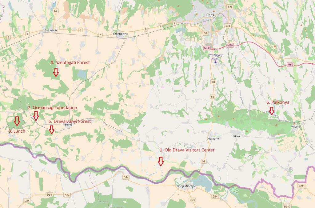
16 SCERIN-5 Day 3, Thursday, 22 June 2017 Scientific Field Trip: Land use change planning of the Old Dráva Program 8:15 Departure in front of the building of the Academy, Jurisics M. str. 44, Pécs app. 9:30 Arrival to Szaporca (stop 1.) 9:30-10:30 Visiting Old Dáva Visiting Center ( Old Dráva Program - Mr Zsolt Tiffán, regional parliamentarian and Governmental Commissioner responsible for the Old Dráva Program, Traditional Floodplain Management - Mr Endre Stelik, ranger Danube-Dráva National Park 11:00 Arrival to Drávafok(stop 2.) 11:00-12:00 For Ormánság Foundation Ecological Fruit-Culture Tamás Lantos, representative of the Ormánság Foundation 12:30 Arrival to Alsóerdei forest(stop 3.) 12:30 13:30 Lunch (Deer stew sponsored by Mecsek Forestry Co. Ltd) Arrival to Szentegát forest(stop 4.) 14:15 15:00 Short history of the Hungarian forest management and visiting the oldest oak forest on the former Dráva floodplain Dénes Molnár, forester Mecsek Forestry Co. Ltd 15:30 Arrival to Drávaivány forest(stop 5.) 15:30-16:30 Floodplain oak forest management Dénes Molnár, forester Mecsek Forestry Co. Ltd 17:30 Arrival to Palkonya(stop 6.) 17:30 19:00 Visiting street of Cellars (wine tasting sponsored by HP) 20:00 Arrival to the Academy, Pécs
17

18
19
20

21 SCERIN Contributes to GOFC-GOLD Gutman, 2015


22 Regional Background Diversity of land forms and environmental conditions has produced a unique richness of species - highly sensitive and vulnerable to climate change. SCEE has undergone extensive land-use, which have rendered many of the natural processes of adaptation un-sustainable. Rich archive of long-term LULC data Archive of methodology for field observations LUCC research established Availability of regional data from individual institutions or projects not always uniformly organized and consistent
23 Identified Priority Topics Collaboration for: sharing of data, experience, and comparative studies Facilitation of LCLUC and regional modeling predictions and forecasts Establish network of field validation sites at regional SCERIN scales, for detecting/interpreting key indicators of land use and land cover change Promote techniques for cost effective monitoring to facilitate frequent, repeated, regionally coordinated assessment
24 Main processes in the present: suburbanization, land abandonment, afforestation, loss of agricultural and especially arable land and dynamics in population density with migration Driving forces: Change in climate and extreme weather events (e.g. floods and fires) EU accession and open market bringing changes in land preservation and land ownership) Forest management and protection of natural environment Transitional processes in population dynamics: Current Specifics population dynamics due to the political situation in proximity to SCERIN EU transitional state to providing solutions, and relations to EU, US, UN and others...

25 Global Reference Validation Database for Accuracy Assessment of Land Cover Role of GOFC-GOLD and the regional networks in verifying classifications and classifying high resolution images Brice Mora, 2013
SCERIN Overview SCERIN-4 Goals and Workshop Agenda
 The GOFC-GOLD South Central and Eastern European Network (SCERIN) SCERIN Overview SCERIN-4 Goals and Workshop Agenda Petya Campbell 1, Jana Albrechtová 2 and Lucie Kupková 2 1 Joint Center for Earth Systems
Current LCLUC challenges in SCERIN: Assessing Ecosystem Function and Processes
 Summary of the SCERIN 2 meeting Current LCLUC challenges in SCERIN: Assessing Ecosystem Function and Processes Katarzyna Ostapowicz Department of GIS, Cartography and Remote Sensing, Institute of Geography
EU collaborations with NASA LCLUC Program & Current Priorities
 & Current Priorities ioannis Manakos, Dr. Centre for Research and Technology Hellas Information Technologies Institute Visual Analytics, Virtual & Augmented Reality Laboratory European Association of Remote
EO Information Services. Assessing Vulnerability in the metropolitan area of Rio de Janeiro (Floods & Landslides) Project
 Project") EO Information Services in support of Assessing Vulnerability in the metropolitan area of Rio de Janeiro (Floods & Landslides) Project Ricardo Armas, Critical Software SA Haris Kontoes, ISARS NOA World
EO Information Services in support of Assessing Vulnerability in the metropolitan area of Rio de Janeiro (Floods & Landslides) Project Ricardo Armas, Critical Software SA Haris Kontoes, ISARS NOA World
European Landscape Convention in the Slovak Republic
 13th COUNCIL OF EUROPE MEETING OF THE WORKSHOPS FOR THE EUROPEAN LANDSCAPE CONVENTION European Landscape Convention in the Slovak Republic Mrs. Ida Vanáková, state advisor, Department of Spatial Planning
GEOMATICS. Shaping our world. A company of
 GEOMATICS Shaping our world A company of OUR EXPERTISE Geomatics Geomatics plays a mayor role in hydropower, land and water resources, urban development, transport & mobility, renewable energy, and infrastructure
LAND COVER CHANGES IN ROMANIA BASED ON CORINE LAND COVER INVENTORY
 LAND COVER CHANGES IN ROMANIA BASED ON CORINE LAND COVER INVENTORY 1990 2012 JENICĂ HANGANU, ADRIAN CONSTANTINESCU * Key-words: CORINE Land Cover inventory, Land cover changes, GIS. Abstract. From 1990
Programme. MC : Byron Anangwe. Morning Session
 Programme MC : Byron Anangwe Morning Session DAY 2 Summary MC : Byron Anangwe The USGS global land cover mapping initiative Land use and land cover mapping at the Joint Research Centre Alan Belward FAO
EuroGEOSS Protected Areas Pilot
 EuroGEOSS Protected Areas Pilot Max Craglia European Commission Joint Research Centre Part 1: the present MyNatura2000 Mobile app. Awareness raising & volunteered data collection. Natura2000 covers 18%
DEPARTMENT OF GEOGRAPHY B.A. PROGRAMME COURSE DESCRIPTION
 DEPARTMENT OF GEOGRAPHY B.A. PROGRAMME COURSE DESCRIPTION (3 Cr. Hrs) (2340100) Geography of Jordan (University Requirement) This Course pursues the following objectives: - The study the physical geographical
GEOGRAPHY (GE) Courses of Instruction
 Courses of Instruction") GEOGRAPHY (GE) GE 102. (3) World Regional Geography. The geographic method of inquiry is used to examine, describe, explain, and analyze the human and physical environments of the major regions of the
GEOGRAPHY (GE) GE 102. (3) World Regional Geography. The geographic method of inquiry is used to examine, describe, explain, and analyze the human and physical environments of the major regions of the
IAEG SDGs WG GI, , Mexico City
 IAEG SDGs WG GI, 12-14.12.2016, Mexico City UN-GGIM:Europe s perspective and activities to support better integration of geospatial information and statistics and the UN SDG monitoring Pier-Giorgio Zaccheddu,
Training on national land cover classification systems. Toward the integration of forest and other land use mapping activities.
 Training on national land cover classification systems Toward the integration of forest and other land use mapping activities. Guiana Shield 9 to 13 March 2015, Paramaribo, Suriname Background Sustainable
Leveraging Sentinel-1 time-series data for mapping agricultural land cover and land use in the tropics
 Leveraging Sentinel-1 time-series data for mapping agricultural land cover and land use in the tropics Caitlin Kontgis caitlin@descarteslabs.com @caitlinkontgis Descartes Labs Overview What is Descartes
GEOGRAPHY (GEOGRPHY) Geography (GEOGRPHY) 1
 Geography (GEOGRPHY) 1") Geography (GEOGRPHY) 1 GEOGRAPHY (GEOGRPHY) GEOGRPHY 1040 Planet Earth 4 Credits The features of the natural environment (lithosphere, atmosphere and hydrosphere); their character, distribution, origin
Geography (GEOGRPHY) 1 GEOGRAPHY (GEOGRPHY) GEOGRPHY 1040 Planet Earth 4 Credits The features of the natural environment (lithosphere, atmosphere and hydrosphere); their character, distribution, origin
Spanish national plan for land observation: new collaborative production system in Europe
 ADVANCE UNEDITED VERSION UNITED NATIONS E/CONF.103/5/Add.1 Economic and Social Affairs 9 July 2013 Tenth United Nations Regional Cartographic Conference for the Americas New York, 19-23, August 2013 Item
Coastal Zones & Ocean Science
 4 th International Conference on Coastal Zones & Ocean Science Theme: Discovering the Innovative methods for the betterment of Coastal and Ocean science Dates: May 15-16, 2019 Venue: https://coastalzonemanagement.conferenceseries.com/
Report on: UNESCO Joint Training Course:
 Report on: UNESCO Joint Training Course: Geospatial Methods, Technologies, and Applications in Monitoring Land Cover, Land Use, Fire and Water in semi-arid regions Central Asia Jointly with NASA LCLUC
Overview of GOFC-GOLD Regional Networks
 Global Observation of Forest and Land Cover Dynamics Overview of GOFC-GOLD Regional Networks Dr. Olga N. Krankina College of Forestry, Oregon State University, USA GOFC-GOLD Regional Networks Coordinator
DEVELOPMENT OF DIGITAL CARTOGRAPHIC DATABASE FOR MANAGING THE ENVIRONMENT AND NATURAL RESOURCES IN THE REPUBLIC OF SERBIA
 DEVELOPMENT OF DIGITAL CARTOGRAPHIC BASE FOR MANAGING THE ENVIRONMENT AND NATURAL RESOURCES IN THE REPUBLIC OF SERBIA Dragutin Protic, Ivan Nestorov Institute for Geodesy, Faculty of Civil Engineering,
Land cover research, applications and development needs in Slovakia
 Land cover research, applications and development needs in Slovakia Andrej Halabuk Institute of Landscape Ecology Slovak Academy of Sciences (ILE SAS) Štefánikova 3, 814 99 Bratislava, Slovakia Institute
Future perspectives for EO in Development
 Future perspectives for EO in Development Meeting at ESA/ESRIN in Frascati 11 th of September 2018 #WorldInCommon AGENCE FRANÇAISE DE DÉVELOPPEMENT FRENCH DEVELOPMENT AGENCY 01. What is AFD? France s international
Building Institutional Capacity for Multi-Hazard Early Warning in Asia and the Pacific Subtitle
 Building Institutional Capacity for Multi-Hazard Early Warning in Asia and the Pacific Subtitle Title Keran Wang Chief, Space Applications Section ICT and Disaster Risk Reduction Division 22 May 2018 Pillar
Current experiences in the use of satellite information in development aid activities
 Current experiences in the use of satellite information in development aid activities Meeting at ESA/ESRIN in Frascati 16 th of September 2017 #WorldInCommon AGENCE FRANÇAISE DE DÉVELOPPEMENT FRENCH DEVELOPMENT
Environmentally-induced Population Displacements: Conclusions from PERN s Online Seminar
 Environment, Forced Migration & Social Vulnerability International Conference 9-11 October 2008 Bonn, Germany www.efmsv2008.org Environmentally-induced Population Displacements: Conclusions from PERN s
4/18/2006 Olga N. Krankina, OSU
 (Northern Eurasia Landcover Dynamics Analysis) Monitoring and validating the distribution and change in land cover across Northern Eurasia Objectives Characterize land cover and its change across boreal
Overview on Land Cover and Land Use Monitoring in Russia
 Russian Academy of Sciences Space Research Institute Overview on Land Cover and Land Use Monitoring in Russia Sergey Bartalev Joint NASA LCLUC Science Team Meeting and GOFC-GOLD/NERIN, NEESPI Workshop
Land Administration and Cadastre
 Geomatics play a major role in hydropower, land and water resources and other infrastructure projects. Lahmeyer International s (LI) worldwide projects require a wide range of approaches to the integration
EO4SEE - THE PATHFINDER OF OPERATIONAL SATELLITE MONITORING FOR THE REGION OF THE BLACK SEA AND CENTRAL EUROPE
 EO4SEE: Pathfinder assessment for regional high volume data access, processing and information service delivery platforms - South East Region EO4SEE - THE PATHFINDER OF OPERATIONAL SATELLITE MONITORING
Prentice Hall. World Explorer: People, Places, Cultures Grade 7. Oklahoma Priority Academic Student Skills (PASS) for Grade 7 World Geography
 for Grade 7 World Geography") Prentice Hall World Explorer: People, Places, Cultures 2007 Grade 7 C O R R E L A T E D T O for Grade 7 1. Locate, gather, analyze, and apply information from primary and secondary sources. WORLD GEOGRAPHY
Prentice Hall World Explorer: People, Places, Cultures 2007 Grade 7 C O R R E L A T E D T O for Grade 7 1. Locate, gather, analyze, and apply information from primary and secondary sources. WORLD GEOGRAPHY
Earth Observation and GEOSS in Horizon Copernicus for Raw Material Workshop 5 th September 2016
 Earth Observation and GEOSS in Horizon 2020 Copernicus for Raw Material Workshop 5 th September 2016 Gilles OLLIER Head of Sector -Earth observation Directorate Environment Unit I.4 Climate Actions and
Second Administrative Level Boundaries (SALB) initiative & geographic names in cartography. Geospatial Information Section
 initiative & geographic names in cartography. Geospatial Information Section") Second Administrative Level Boundaries (SALB) initiative & geographic names in cartography Geospatial Information Section Introduction Goals Global agenda How does SALB work? Latest News on geographic
Second Administrative Level Boundaries (SALB) initiative & geographic names in cartography Geospatial Information Section Introduction Goals Global agenda How does SALB work? Latest News on geographic
27 28 June Bruges, BELGIUM
 27 28 June 2017 - Bruges, BELGIUM MultiTemp 2017 Technical Programme Gabrielle De Lannoy, Else Swinnen Overview Programme Tuesday 27/06 Wednesday 28/06 Thursday 29/06 8:30 Registration 8:00 Registration
Empowered lives. Resilient nations. Data for People and Planet. powered by
 Empowered lives. Resilient nations. Data for People and Planet powered by Overview As we enter the fourth industrial revolution, technology is revolutionizing our ability to map nature. Satellite data
Harmonizing spatial databases and services at local and regional level
 Harmonizing spatial databases and services at local and regional level A. Ionita 1, M. Caian 2, V. Vassilev 3, V. Craciunescu 2, I. Nedelcu 4 1 Research Institute for Artificial Intelligence, Bucuresti,
Natura 2000 and spatial planning. Executive summary
 Natura 2000 and spatial planning Executive summary DISCLAIMER The information and views set out in this study are those of the author(s) and do not necessarily reflect the official opinion of the Commission.
Mapping Water Resources and Reservoirs for Climate Resilience in Zambezi River Basin
 Mapping Water Resources and Reservoirs for Climate Resilience in Zambezi River Basin Corné van der Sande, NEO BV Senior Advisor Earth Observation Services for Monitoring Drought and Water Resources in
Building Institutional Capacity for Multi-Hazard Early Warning in Pacific Countries Subtitle
 Building Institutional Capacity for Multi-Hazard Early Warning in Pacific Countries Subtitle Title Keran Wang Chief, Space Applications Section ICT and Disaster Risk Reduction Division 30 March 2018 Slide
European Initiatives on Drought: Research Projects and Networks
 European Initiatives on Drought: Research Projects and Networks Kerstin Stahl Department of Geosciences University of Oslo Oslo, Norway Outline Drought in Europe: events and issues Previous research on
Urban Climate Resilience
 Urban Climate Resilience in Southeast Asia Partnership Project Introduction Planning for climate change is a daunting challenge for governments in the Mekong Region. Limited capacity at the municipal level,
An Update on Land Use & Land Cover Mapping in Ireland
 An Update on Land Use & Land Cover Mapping in Ireland Progress Towards a National Programme Kevin Lydon k.lydon@epa.ie Office of Environmental Assessment, Environmental Protection Agency, Johnstown Castle,
Land Use / Land Cover Mapping in
 Land Use / Land Cover Mapping in Eastern and Southern African Regions RCMRD Experience by 6/24/2013, Nairobi Kenya Dr. Tesfaye Korme Director of RS, GIS and Mapping, RCMRD I. About RCMRD, Its Vision and
Copernicus Overview and Emergency Management Service
 Copernicus Overview and Emergency Management Service Frédéric BASTIDE European Commission Open informal session of the United Nations Inter-Agency Meeting on Outer Space Activities 12 March 2013, Geneva
I&CLC2000 in support to new policy initiatives (INSPIRE, GMES,..)
") I&CLC2000 in support to new policy initiatives (INSPIRE, GMES,..) Manfred Grasserbauer, Director Joint Research Centre Institute for Environment and Sustainability 1 IMAGE 2000 European mosaic of satellite
I&CLC2000 in support to new policy initiatives (INSPIRE, GMES,..) Manfred Grasserbauer, Director Joint Research Centre Institute for Environment and Sustainability 1 IMAGE 2000 European mosaic of satellite
Skype: konrad.turlej phone:
 Konrad Ireneusz Turlej Silvis Lab Department of Forest and Wildlife Ecology 1630 Linden Drive, WI, 53706, USA E-mail: turlej@wisc.edu Skype: konrad.turlej phone: +1-608-999-0811 Education: Since 2014 -
Implementing the Sustainable Development Goals: The Role of Geospatial Technology and Innovation
 Fifth High Level Forum on UN Global Geospatial Information Management Implementing the Sustainable Development Goals: The Role of Geospatial Technology and Innovation 28-30 November 2017 Sheraton Maria
Poland, European Territory, ESPON Programme Warsaw, 2 July 2007 STRATEGY OF THE ESPON 2013 PROGRAMME
 Poland, European Territory, ESPON Programme 2007-2013 Warsaw, 2 July 2007 STRATEGY OF THE ESPON 2013 PROGRAMME Territory matters Regional diversity as asset Territorial potentials increasing in importance
CONFERENCE STATEMENT
 CONFERENCE STATEMENT We, the elected representatives from Canada, Denmark/Greenland, Finland, Iceland, Norway, Russia, Sweden and the United States of America; In collaboration with the indigenous peoples
Geospatial technology for land cover analysis
 Home Articles Application Environment & Climate Conservation & monitoring Published in : Middle East & Africa Geospatial Digest November 2013 Lemenkova Polina Charles University in Prague, Faculty of Science,
Pathways. Pathways through the Geography Major
 Pathways through the Major majors may structure their course selections around a sub-field of. Pathways are suggestions for classes in, in related disciplines, and skills training. Each pathway includes
Data sources and classification for ecosystem accounting g
 Data sources and classification for ecosystem accounting Ken Bagstad 23 February 2015 Wealth Accounting and the Valuation of Ecosystem Services www.wavespartnership.org Data sources and classification
GIS Solutions in Natural Resource Management: Balancing the Technical- Political Equation
 GIS Solutions in Natural Resource Management: Balancing the Technical- Political Equation Stan Morain, Editor SUB Gdttlngen 7 208 520 309 98 A14447 0NW0RD PRESS V? % \
Interregional Cooperation in the Apennines
 INTERNATIONAL WORKSHOP THE ALPS AND THE ARDENNES: SHARING EXPERIENCES AMONG TRANSBOUNDARY MOUNTAIN AREAS Interregional Cooperation in the Apennines Massimo Sargolini, professor at the University of Camerino,
TOPO-EUROPE: 4D Topography Evolution in Europe: Uplift, Subsidence and Sea Level Rise
 Exploratory workshop Budapest, Hungary 17-18 March 2005 ESF ILP Academia Europaea ELTE ISES GFZ TOPO-EUROPE Geoscience of coupled lithosphere/mantle and surface processes of continental Europe and its
MANUAL ON THE BSES: LAND USE/LAND COVER
 6. Environment Protection, Management and Engagement 2. Environmental Resources and their Use 5. Human Habitat and Environmental Health 1. Environmental Conditions and Quality 4. Disasters and Extreme
Navigable maritime and river waterways in the seaside - Danube Delta area and the connected rural development
 SUMMARY OF Ph-D Thesis, with title RESEARCH STUDIES ON MANAGEMENT IMPROVEMENT OF MARITIME AND RIVER TRANSPORT ACTIVITY IN THE COASTAL AND DANUBE DELTA AREA FROM AN ENVIROMENTAL, ECONOMIC AND SOCIAL PERSPECTIVE
7/8/2010 Olga N. Krankina, OSU
 Northern Eurasia Regional Information Network Olga N. Krankina Department of Forest Science Oregon State University Motivation Northern Eurasia (NE) is the largest landmass, the largest terrestrial reservoir
INTEGRATING GEOSPATIAL PERSPECTIVES IN THE ANTHROPOLOGY CURRICULUM AT THE UNIVERSITY OF NEW MEXICO (UNM)
") INTEGRATING GEOSPATIAL PERSPECTIVES IN THE ANTHROPOLOGY CURRICULUM AT THE UNIVERSITY OF NEW MEXICO (UNM) VERONICA ARIAS HEATHER RICHARDS JUDITH VAN DER ELST DEPARTMENT OF ANTHROPOLOGY MARCH 2005 INTEGRATING
INTEGRATING GEOSPATIAL PERSPECTIVES IN THE ANTHROPOLOGY CURRICULUM AT THE UNIVERSITY OF NEW MEXICO (UNM) VERONICA ARIAS HEATHER RICHARDS JUDITH VAN DER ELST DEPARTMENT OF ANTHROPOLOGY MARCH 2005 INTEGRATING
CLLD Cooperation OFFER
 Title of the proposed project (English) CLLD Cooperation OFFER PARKS PROTECTION III - Management, Protection and Economic Development in Protected Areas Type of project (select as many as you want) Cooperation
Geography General Course Year 12. Selected Unit 3 syllabus content for the. Externally set task 2019
 Geography General Course Year 12 Selected Unit 3 syllabus content for the Externally set task 2019 This document is an extract from the Geography General Course Year 12 syllabus, featuring all of the content
Pee Dee Explorer. Science Standards
 Science Standards About Pee Dee Explorer What does it mean when someone says they are from the "Pee Dee" of South Carolina? A place is bigger than its physical geography. A "sense of place" weaves together
The UN-GGIM: Europe core data initiative to encourage Geographic information supporting Sustainable Development Goals Dominique Laurent, France
 INSPIRE conference Strasbourg 6 September 2017 The UN-GGIM: Europe core data initiative to encourage Geographic information supporting Sustainable Development Goals Dominique Laurent, France Introduction
Framework on reducing diffuse pollution from agriculture perspectives from catchment managers
 Framework on reducing diffuse pollution from agriculture perspectives from catchment managers Photo: River Eden catchment, Sim Reaney, Durham University Introduction This framework has arisen from a series
Crowdsourcing approach for large scale mapping of built-up land
 Crowdsourcing approach for large scale mapping of built-up land Kavinda Gunasekara Kavinda@ait.asia Geoinformatics Center Asian Institute of Technology, Thailand. Regional expert workshop on land accounting
RANGE AND ANIMAL SCIENCES AND RESOURCES MANAGEMENT - Vol. II - Catchment Management A Framework for Managing Rangelands - Hugh Milner
 CATCHMENT MANAGEMENT A FRAMEWORK FOR MANAGING RANGELANDS Hugh Milner International Water Management Consultant, Australia Keywords: Rangeland management; catchments and watersheds; catchment management
Applying Hazard Maps to Urban Planning
 Applying Hazard Maps to Urban Planning September 10th, 2014 SAKAI Yuko Disaster Management Expert JICA Study Team for the Metro Cebu Roadmap Study on the Sustainable Urban Development 1 Contents 1. Outline
2018/1 The integration of statistical and geospatial information. The Regional Committee of UN-GGIM: Americas:
 The following are the conclusions and recommendations of the Regional Committee of the United Nations on Global Geospatial Information Management for the Americas, during its Fifth Session, Thursday 8
Dynamic Land Cover Dataset Product Description
 Dynamic Land Cover Dataset Product Description V1.0 27 May 2014 D2014-40362 Unclassified Table of Contents Document History... 3 A Summary Description... 4 Sheet A.1 Definition and Usage... 4 Sheet A.2
Plan4all (econtentplus project)
") Plan4all (econtentplus project) Karel CHARVAT 1, Tomáš MILDORF 2 1 Help service remote sensing, Ltd., Černoleská 1600, 256 01 Benešov u Prahy, Czech Republic charvat@bnhelp.cz 2 Department of Mathematics
Plan4all (econtentplus project) Karel CHARVAT 1, Tomáš MILDORF 2 1 Help service remote sensing, Ltd., Černoleská 1600, 256 01 Benešov u Prahy, Czech Republic charvat@bnhelp.cz 2 Department of Mathematics
Abstract: About the Author:
 REMOTE SENSING AND GIS IN LAND USE PLANNING Sathees kumar P 1, Nisha Radhakrishnan 2 1 1 Ph.D Research Scholar, Department of Civil Engineering, National Institute of Technology, Tiruchirappalli- 620015,
GMES and AFRICA Support Programme 1st technical committee meeting
 GMES and AFRICA Support Programme 1st technical committee meeting Developing an Earth Observation Operational Application for Coastal Ecosystems Mapping, Monitoring and Assessment of the Northern African
Studies on adaptation capacity of Carpathian ecosystems/landscape to climate change
 ` Studies on adaptation capacity of Carpathian ecosystems/landscape to climate change Science for the Carpathians CARPATHIAN CONVENTION COP5 Lillafüred, 10.10.2017-12.10.2017 Marcel Mîndrescu, Anita Bokwa
Climate Change and Mapping of the Future Nature
 Climate Change and Mapping of the Future Nature The XXIV FIG International Congress 2010 TS 4E Coasts and Natural Resources Tuesday 13 April Mr. Jesper Rye Rasmussen Denmark on the map Sydney, Australia,
ENVS S102 Earth and Environment (Cross-listed as GEOG 102) ENVS S110 Introduction to ArcGIS (Cross-listed as GEOG 110)
 ENVS S110 Introduction to ArcGIS (Cross-listed as GEOG 110)") ENVS S102 Earth and Environment (Cross-listed as GEOG 102) 1. Describe the fundamental workings of the atmospheric, hydrospheric, lithospheric, and oceanic systems of Earth 2. Explain the interactions
ENVS S102 Earth and Environment (Cross-listed as GEOG 102) 1. Describe the fundamental workings of the atmospheric, hydrospheric, lithospheric, and oceanic systems of Earth 2. Explain the interactions
Compact guides GISCO. Geographic information system of the Commission
 Compact guides GISCO Geographic information system of the Commission What is GISCO? GISCO, the Geographic Information System of the COmmission, is a permanent service of Eurostat that fulfils the requirements
Space Application in Support of Land Management for SDG Implementation
 Space Application in Support of Land Management for SDG Implementation Regional Expert Workshop on Land Accounting for SDG Monitoring and Reporting 26 September 2017 Space Application Section Information
Regional Centre for Mapping of Resources for Development (RCMRD), Nairobi, Kenya
, Nairobi, Kenya") Regional Centre for Mapping of Resources for Development (RCMRD), Nairobi, Kenya Introduction to GIS (2 weeks: 10 days) Intakes: 8 th January, 6 th February, 5th March, 3 rd. April 9 th, May 7 th, June
Regional Centre for Mapping of Resources for Development (RCMRD), Nairobi, Kenya Introduction to GIS (2 weeks: 10 days) Intakes: 8 th January, 6 th February, 5th March, 3 rd. April 9 th, May 7 th, June
cooperating sites as the three initial units of a new Southern Appalachian Biosphere Reserve, approved by UNESCO in 1988.
 -» TOWARD A U.S. MODALITY OF BIOSPHERE RESERVES: THE SOUTHERN APPALACHIAN BIOSPHERE RESERVE William s_ P. Gregg, Chief, International Affairs Office, National Biological Service, Washington, D.C. Hubert
SYNTHESIS OF LCLUC STUDIES ON URBANIZATION: STATE OF THE ART, GAPS IN KNOWLEDGE, AND NEW DIRECTIONS FOR REMOTE SENSING
 PROGRESS REPORT SYNTHESIS OF LCLUC STUDIES ON URBANIZATION: STATE OF THE ART, GAPS IN KNOWLEDGE, AND NEW DIRECTIONS FOR REMOTE SENSING NASA Grant NNX15AD43G Prepared by Karen C. Seto, PI, Yale Burak Güneralp,
The ESPON Programme. Goals Main Results Future
 The ESPON Programme Goals Main Results Future Structure 1. Goals Objectives and expectations Participation, organisation and networking Themes addressed in the applied research undertaken in ESPON projects
Historical Assessment of Spatial Growth of Built-ups and Metropolitan areas of Delhi and Mumbai in India and Dhaka in Bangladesh
 Historical Assessment of Spatial Growth of Built-ups and Metropolitan areas of Delhi and Mumbai in India and Dhaka in Bangladesh Tomas Soukup, GISAT World Bank HQ, Washington DC Date : 12 April 2011 Introduction
Climate Change: How it impacts Canadians and what we can do to slow it down.
 Climate Change: How it impacts Canadians and what we can do to slow it down. Lesson Overview This lesson takes stock of how climate change has already affected Canadians in geographic, economic, and cultural
Urban Studies Applicable to students admitted in
 Urban Studies Applicable to students admitted in 2014-15 Major Programme Requirement Students are required to complete a minimum of 8 units of courses as follows: 1. Faculty Package: 9 Any three courses,
Egypt-NOAA Cooperation: Advancing our Environmental Science, Technology, and Education
 Egypt-NOAA Cooperation: Advancing our Environmental Science, Technology, and Education T. G. Onsager NOAA Space Weather Prediction Center and NWS International Activities Office (one-year detail) Terry.Onsager@noaa.gov
Lesson Plan 3 Land Cover Changes Over Time. An Introduction to Land Cover Changes over Time
 An Introduction to Land Cover Changes over Time This lesson plan builds on the lesson plan on Understanding Land Use and Land Cover Using Google Earth. Please refer to it in terms of definitions on land
GMES Service for Geospatial Reference Data Access (RDA) Covering Areas Outside Europe
 Covering Areas Outside Europe") INSPIRE Conference 2011 Edinburgh 27 June - 1 July GMES Service for Geospatial Reference Data Access (RDA) Covering Areas Outside Europe Andrea Ajmar, Simone Balbo, Piero Boccardo, Simone Dalmasso, Anna
INSPIRE Conference 2011 Edinburgh 27 June - 1 July GMES Service for Geospatial Reference Data Access (RDA) Covering Areas Outside Europe Andrea Ajmar, Simone Balbo, Piero Boccardo, Simone Dalmasso, Anna
EBA Engineering Consultants Ltd. Creating and Delivering Better Solutions
 EBA Engineering Consultants Ltd. Creating and Delivering Better Solutions ENHANCING THE CAPABILITY OF ECOSYSTEM MAPPING TO SUPPORT ADAPTIVE FOREST MANAGEMENT Prepared by: EBA ENGINEERING CONSULTANTS LTD.
Carpathians Unite mechanism of consultation and cooperation for implementation of the Carpathian Convention
 Carpathians Unite mechanism of consultation and cooperation for implementation of the Carpathian Convention Zbigniew Niewiadomski, UNEP/GRID-Warsaw Centre First Joint Meeting of the Carpathian Convention
Regional Centre for Mapping of Resources for Development (RCMRD), Nairobi, Kenya
, Nairobi, Kenya") Regional Centre for Mapping of Resources for Development (RCMRD), Nairobi, Kenya Introduction GIS ( 2 weeks: 10 days) Intakes: 7 th Jan, 4 th Feb,4 th March, 1 st April 6 th May, 3 rd June, 1 st July,
Regional Centre for Mapping of Resources for Development (RCMRD), Nairobi, Kenya Introduction GIS ( 2 weeks: 10 days) Intakes: 7 th Jan, 4 th Feb,4 th March, 1 st April 6 th May, 3 rd June, 1 st July,
Plenary Session 2, part 2 A European shared information system
 3 rd GMES Forum 5 6 June 2003 Athens Plenary Session 2, part 2 A European shared information system Gordon McInnes Deputy Director European Environment Agency 1 I keep six honest serving men. They taught
Virginia Shoreline Mapping Tools
 Virginia Shoreline Mapping Tools December 15, 2017 Karen Duhring Center for Coastal Resources Management Virginia Institute of Marine Science College of William & Mary Virginia Shoreline Mapping Tools
What is a watershed or landscape perspective?
 What is a watershed or landscape perspective? -remove sediment -add sediment -add wood, riparian manipulation -alter (engineer) channel/floodplain morphology -restore/abandon roads You are here What is
Applying GIS to Coastal Management in Cork Harbour: the Corepoint experience
 Applying GIS to Coastal Management in Cork Harbour: the Corepoint experience Kathrin Köpke University College Cork, Ireland Thematic Conference: THE WATERFRONT MANAGEMENT AND GI (IT), 14 th -18 th November
Flood management in Namibia: Hydrological linkage between the Kunene River and the Cuvelai Drainage System: Cuvelai-Etosha Basin
 Flood management in Namibia: Hydrological linkage between the Kunene River and the Cuvelai Drainage System: Cuvelai-Etosha Basin By: Leonard Hango Department of Water Affairs and Forestry Ministry of Agriculture
AND THE COOPERATION WITH SENTINEL ASIA FOR DISASTER MANAGEMENT
 Ministry of Natural resources and Environment National Remote Sensing DEpartment NATIONAL REMOTE SENSING DEPARTMENT (NRSD) AND THE COOPERATION WITH SENTINEL ASIA FOR DISASTER MANAGEMENT By: Dr. Chu Hai
Geography (GEOG) Introduction to Geography Global Change and Natural Disasters and Environmental Change
 Introduction to Geography Global Change and Natural Disasters and Environmental Change") Geography (GEOG) Head of Department: Professor Jeffrey P. Osleeb Department Office: Room 422, Philip E. Austin Building For major requirements, see the College of Liberal Arts and Sciences section of this
Geography (GEOG) Head of Department: Professor Jeffrey P. Osleeb Department Office: Room 422, Philip E. Austin Building For major requirements, see the College of Liberal Arts and Sciences section of this
ACTION PLAN FOR WORLD HERITAGE IN LATIN AMERICA AND THE CARIBBEAN ( )
") Annex ACTION PLAN FOR WORLD HERITAGE IN LATIN AMERICA AND THE CARIBBEAN (2014-2024) The current Regional Action Plan for Latin America and the Caribbean for 2014-2024 has been elaborated by the State Parties
Annex ACTION PLAN FOR WORLD HERITAGE IN LATIN AMERICA AND THE CARIBBEAN (2014-2024) The current Regional Action Plan for Latin America and the Caribbean for 2014-2024 has been elaborated by the State Parties
DC Educational Standards Science Grade: 6 - Adopted: Matter and Its Interactions
 Main Criteria: DC Educational Standards Secondary Criteria: Subjects: Science, Social Studies Grade: 6 Correlation Options: Show Correlated ESSENTIAL DC.MS-PS. MS-PS1. DC Educational Standards Science
FRAGMENTATION OF LANDSCAPES WITH CONSERVATION VALUE IN SOUTH PIRIN AND SLAVYANKA MOUNTAIN (SOUTH-WESTERN BULGARIA)
") FRAGMENTATION OF LANDSCAPES WITH CONSERVATION VALUE IN SOUTH PIRIN AND SLAVYANKA MOUNTAIN (SOUTH-WESTERN BULGARIA) Atanas Kitev, Rumiana Vatseva Assist. Prof. Atanas Kitev, Ph.D.; Prof. Rumiana Vatseva,
FRAGMENTATION OF LANDSCAPES WITH CONSERVATION VALUE IN SOUTH PIRIN AND SLAVYANKA MOUNTAIN (SOUTH-WESTERN BULGARIA) Atanas Kitev, Rumiana Vatseva Assist. Prof. Atanas Kitev, Ph.D.; Prof. Rumiana Vatseva,
ZRCSAZU. Remote sensing and Earth observation data at ZRC SAZU. dr. Tatjana Veljanovski Atrij ZRC Ljubljana
 ZRCSAZU Remote sensing and Earth observation data at ZRC SAZU dr. Tatjana Veljanovski 2016-06-08 Atrij ZRC Ljubljana Remote Sensing Department Remote Sensing Department 20 years of experience application,